Showing 14 items matching "castle camps"
-
 Whitehorse Historical Society Inc.
Document, Family history of Abraham Rooks, 2000
... ...Castle Camps...With immigration shipping record, Rooks family history summaries; search results from international genealogical index; history of Castle Camps (England), family place of origin....School project by Ross Hamilton on Abraham Rooks, 1824 - 1889, with immigration shipping record, Rooks family history summaries; search results from international genealogical index; history of Castle Camps (England), family place of origin....Rooks Charles Francis Rooks Abraham 1788 - 1869 Rooks Abraham 1824 - 1889 Castle Camps England Rooks Family Forest Hill School project by Ross Hamilton on Abraham Rooks, 1824 - 1889. ...School project by Ross Hamilton on Abraham Rooks, 1824 - 1889.School project by Ross Hamilton on Abraham Rooks, 1824 - 1889, with immigration shipping record, Rooks family history summaries; search results from international genealogical index; history of Castle Camps (England), family place of origin.School project by Ross Hamilton on Abraham Rooks, 1824 - 1889.rooks, charles francis, rooks, abraham, 1788 - 1869, rooks, abraham, 1824 - 1889, castle camps, england, rooks family, forest hill -
 Kiewa Valley Historical Society
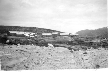
11 Black and White photographs of the Rocky Valley area, c1948
... Of historical importance to understand the conditions in the early construction of the Kiewa Hydro Electric Scheme Rocky Valley; Pretty Valley; Ruined Castle; Bogong High Plains; Kiewa Hydro Electric Scheme Photo No. 1 - on the back, printed in ink"Rocky Valley - New Mess & offices Dec. 1948". In pencil '14 on the back Photo No. 2 - on the back, printed in ink "Rocky Valley Camp. ...In October 1947 construction was commenced on the erection of the workmen's camp at Rocky Valley. Also in 1947 construction of a stream diversion was commenced to allow excavation to commence for the dam wall. In the summer of 1948/49, stripping of the foundation area on both sides of the river was carried out. Weather conditions were not always favourable during the construction, particularly 1955/56 summer, and work would have to cease each year for the winter season due to the severe conditions. The dam is a earth and rock fill structure with a height of about 30.5 metres and crest length 518.16 metres and was completed in March, 1959.These photographs show the type of terrain in the area prior to the construction and filling of Rocky Valley Dam. Also of interest is the type of accommodation provided for those working on the construction and the early cranes available in the 1940/50's. Of historical importance to understand the conditions in the early construction of the Kiewa Hydro Electric SchemeEleven small black and white photographsPhoto No. 1 - on the back, printed in ink"Rocky Valley - New Mess & offices Dec. 1948". In pencil '14 on the back Photo No. 2 - on the back, printed in ink "Rocky Valley Camp. October 1948". Also stamped on the back "998L" Photo No. 3 -on the back, printed in ink "Rocky Valley Hostel October 1948". Also stamped on the back '998L' Photo No. 4 - on the back, printed in ink "Spion Kopje from bedroom window. October 1948". Stamped on the back '998L'. Photo No. 5 - on the back, printed in ink "Rocky Valley Basin Dec. 1948." In pencil on back, 14. Photo No. 6 - on the back, printed in ink "Site of Wall for Rocky Valley Dam Dec. 1948". In pencil on back, 14. Photo No. 7 - On the back, printed in ink "Commencing of Diversion Tunnel Rocky Valley December 1948". In pencil on back, 14. Photo No. 8 - on the back, printed in ink "One of the two electric cranes at Rocky Valley December 1948". In pencil on back, 14. Photo No. 9 - on the back, printed in ink "'Rapier' (H.Y.) electric crane Rocky Valley December 1948". In pencil on back, 14 . Photo No. 10 - on the back, printed in ink " Pretty Valley Pump line construction Mt. Cope in Background Nov 1948. Circular stamp with the words 'print by Wilson White Albury' in the circle. Photo No. 11 - on the back, printed in ink "Stringing cable on Ruined Castle October 1948. Same stamp as No. 10. In pencil '31'. rocky valley; pretty valley; ruined castle; bogong high plains; kiewa hydro electric scheme -
 Kiewa Valley Historical Society
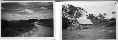
18 small black and white photographs of the Bogong High Plains, 1948
... McKay from Ruined Castle October 1948. Photo 6 View from Rocky Valley Camp October 1948. ...McKay from Ruined Castle October 1948. Photo 6 View from Rocky Valley Camp October 1948. ...These photos of the Bogong High Plains were all taken by Ronald George Thorn who was a cadet engineer with the State Electricity Commission. He worked on the Kiewa scheme from 1948 to 1950 doing overhead line construction and maintenance plus electrical design and drawing work. They are from his personal collection and a record of his time in the Kiewa area.Pictorial history of personal involvement in the the early days of the Kiewa Scheme.18 small black and white photographs all taken on the Bogong High Plains.Photo 1 Wallace's Hut. Photo 2 Ruined Castle - Looking towards Pretty Valley December 1948. Photo 3 Ruined Castle - Looking towards Pretty Valley December 1948. Photo 4 Ruined Castle - Looking Down Valley December 1948. Photo 5 - Mt. McKay from Ruined Castle October 1948. Photo 6 View from Rocky Valley Camp October 1948. Photo 7 Mt. Feather Top from Ruined Castle October 1948. Photo 8 View from Ruined Castle looking downwards towards Beauty October 1948. Photo 9 Rocky River from gauging station October 1948. Photo 10 Rocky Valley River from main road October 1948. Photo 11 View along little Arthur Fire Track October 1948. Photo 12 View along main road. Looking towards Beauty Valley October 1948. Photo 13 View from Little Arthur Fire Track October 1948. Photo 14 Frying Pan Spur from Rocky Valley Road October 1948. Photo 15 Mt. Bogong from Big Hill Fire Track October 1948. Photo 16 View from Big Hill Fire Track October 1948. Photo 17 Mt. Feathertop from Ruined Castle October 1948. Photo 18 Mt. Fainter from Ruined Castle October 1948. (All of the above is hand written on the back of photos in ink). bogong high plains; r g thorn; secv; kiewa hydro electric scheme; pictorial history -
 Greensborough Historical Society
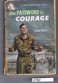
Book, John Castle, The Password is courage, 1956_
... Greensborough Historical Society 34A Glenauburn Road Lower Plenty Lower Plenty melbourne Story of Charles Coward, a British POW who carried out sabotage and resistance activities in various camps including Auschwitz. prisoner of war camps world war 2 286 p. pbk. The Password is courage Book Book John Castle Transworld Publishers ...Story of Charles Coward, a British POW who carried out sabotage and resistance activities in various camps including Auschwitz.286 p. pbk.prisoner of war camps, world war 2 -
 Monbulk RSL Sub Branch
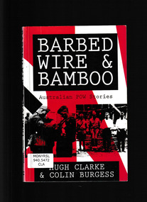
Book, Hugh V. Clarke and Colin Burgess, Barbed wire and bamboo : Australian POWs in Europe, North Africa, Singapore, Thailand and Japan, 1993
... Covering experiences in Europe and in South East Asia, the book presents contrasting PoW experiences - of daring escapes from Colditz Castle, and of endurance and slow suffering in Japanese camps. Ill, maps, p.159 Barbed wire and bamboo : Australian POWs in Europe, North Africa, Singapore, Thailand and Japan Book Hugh V. ...A collection of stories of capture, imprisonment and escape in World War I and II. Covering experiences in Europe and in South East Asia, the book presents contrasting PoW experiences - of daring escapes from Colditz Castle, and of endurance and slow suffering in Japanese camps.Ill, maps, p.159A collection of stories of capture, imprisonment and escape in World War I and II. Covering experiences in Europe and in South East Asia, the book presents contrasting PoW experiences - of daring escapes from Colditz Castle, and of endurance and slow suffering in Japanese camps.world war 1939 – 1945 - prisons and prisoners - japanese, world war 1939 – 1945 - prisons and prisoners – germany -
 Bendigo Historical Society Inc.
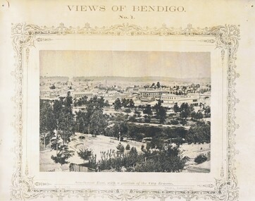
Photograph - NICHOLAS CAIRE VIEWS OF BENDIGO
... Paul's Church, tower and belfry. 9) View of the Camp Reserve as seen from the Court House. 10) View of North Old Chum showing surface excavations. 11) View as seen from the Camp Hill near the lodge. 12) Garden Gully amalgamated claims. 13) Shamrock Hotel, Sandhurst. 14) View as seen from Court House showing the willows & East Pall Mall. 15) Wesleyan Church, Golden Square. 16) Savings bank, Sandhurst. 17) The Bendigo district hospital. 18) Interior of the Wesleyan Church, Golden Square. 19) View of Golden Square township. 20) The Town Hall, City of Sandhurst. 21) The City Hotel, Sandhurst. 22) Pall Mall, Sandhurst. 23) Sandhurst City Market. 24) Pall Mall, Sandhurst looking west. 25) View from Camp Hill looking north - east 26) View of Charing Cross, Sandhurst. 27) View of Sandhurst as seen from Knipe's Castle. 28) Township of Long Gully. 29) View taken from St. ...Paul's Church, tower and belfry. 9) View of the Camp Reserve as seen from the Court House. 10) View of North Old Chum showing surface excavations. 11) View as seen from the Camp Hill near the lodge. 12) Garden Gully amalgamated claims. 13) Shamrock Hotel, Sandhurst. 14) View as seen from Court House showing the willows & East Pall Mall. 15) Wesleyan Church, Golden Square. 16) Savings bank, Sandhurst. 17) The Bendigo district hospital. 18) Interior of the Wesleyan Church, Golden Square. 19) View of Golden Square township. 20) The Town Hall, City of Sandhurst. 21) The City Hotel, Sandhurst. 22) Pall Mall, Sandhurst. 23) Sandhurst City Market. 24) Pall Mall, Sandhurst looking west. 25) View from Camp Hill looking north - east 26) View of Charing Cross, Sandhurst. 27) View of Sandhurst as seen from Knipe's Castle. 28) Township of Long Gully. 29) View taken from St. ...Full set (52 photos) of Nicholas Caire ''Views of Bendigo'' photographs. 1) Sandhurst East with a portion of the City Reserve. 2) New Chum line of reef. 3) Sandhurst-North part as seen from the top of the Masonic Hall. 4) The Hustler's line of reef seen from Redan Hill. 5) Battery of stampers for crushing quartz 6) View of Sandhurst as seen from the top of the New Masonic Hall. 7) Excavation of quartz reef near Ironbark Hill. 8) St. Paul's Church, tower and belfry. 9) View of the Camp Reserve as seen from the Court House. 10) View of North Old Chum showing surface excavations. 11) View as seen from the Camp Hill near the lodge. 12) Garden Gully amalgamated claims. 13) Shamrock Hotel, Sandhurst. 14) View as seen from Court House showing the willows & East Pall Mall. 15) Wesleyan Church, Golden Square. 16) Savings bank, Sandhurst. 17) The Bendigo district hospital. 18) Interior of the Wesleyan Church, Golden Square. 19) View of Golden Square township. 20) The Town Hall, City of Sandhurst. 21) The City Hotel, Sandhurst. 22) Pall Mall, Sandhurst. 23) Sandhurst City Market. 24) Pall Mall, Sandhurst looking west. 25) View from Camp Hill looking north - east 26) View of Charing Cross, Sandhurst. 27) View of Sandhurst as seen from Knipe's Castle. 28) Township of Long Gully. 29) View taken from St. Paul's tower. 30) View of the Sandhurst cemetery at back creek. 31) Kock's pioneer quartz crushing plant, Long Gully. 32) The New Masonic Hall, Sandhurst. 33) The Bendigo benevolent asylum and industrial school. 34) Bendigo flat as seen from Wattle Hill. 35) View of Old Chum Hill. 36) New Chum Gully as seen from Specimen Hill. 37) Township of Eaglehawk. 38) View from St. Paul's tower looking south west. 39) View of the railway tunnel through the Big Hill, near Mt. Herbert. 40) View taken from St. Paul's looking south. 41) Scene taken from St. Paul's tower looking eastward. 42) View of Sandhurst from St. Paul's tower looking north-west. 43) The great extended Hustler's co's. quartz mining claim. 44) View from the Big Hill showing the line of railway to Melbourne. 45) View from St. Paul's Church tower looking westward. 46) View from St. Paul's Church tower looking north-west. 47) Scene near the Big Hill ranges taken from Mr. Buick's residence. 48) View from St. Paul's Church tower looking north eastward. 49) Township of Eaglehawk 50) View of Mitchell Street, Sandhurst. 51) Botanical gardens near the White Hills. 52) View Point, Sandhurst.bendigo, streetscape, various views, nicholas cairne -
 Sunshine and District Historical Society Incorporated
Photograph - Sunshine & District Photographs
... |Coles Hampshire Rd Sunshine Opening Day C1951 (Replaced the store of JW McGrath & Co)|ICI Deer Park C1920's|Old Braybrook Shire Hall|Hunt Club Hotel Deer Park|House photos and street phto perhaps of Sunshine includes 179 Morris St Sunshine|Melbourne Meat Preserving Works (later Hume Site) Maribyrnong River|Raleigh's Castle Maribyrnong River (Highpint West nowadays)|Maribyrnong Swimming Club and Syd Dunne 1921|AIF Lighthorse Camp or Remount Depot Maribyrnong C1920 (Later ordinance factory site)|Riverview Tea Gardens Tennis Etc Maribyrnong River|Angler's Hotel Maribyrnong River|Maribyrnong River near Ordinance Factory area eary 1900's|Maribyrnong River in flood 1906|Other area of Maribyrnong River photos|Feamle workers|Women hand sewing gloves ammunition workers|Kororoit Creek in flood with Parson's house and horse hair factory in the blackground|Gum tree and sheds...|Coles Hampshire Rd Sunshine Opening Day C1951 (Replaced the store of JW McGrath & Co)|ICI Deer Park C1920's|Old Braybrook Shire Hall|Hunt Club Hotel Deer Park|House photos and street phto perhaps of Sunshine includes 179 Morris St Sunshine|Melbourne Meat Preserving Works (later Hume Site) Maribyrnong River|Raleigh's Castle Maribyrnong River (Highpint West nowadays)|Maribyrnong Swimming Club and Syd Dunne 1921|AIF Lighthorse Camp or Remount Depot Maribyrnong C1920 (Later ordinance factory site)|Riverview Tea Gardens Tennis Etc Maribyrnong River|Angler's Hotel Maribyrnong River|Maribyrnong River near Ordinance Factory area eary 1900's|Maribyrnong River in flood 1906|Other area of Maribyrnong River photos|Feamle workers|Women hand sewing gloves ammunition workers|Kororoit Creek in flood with Parson's house and horse hair factory in the blackground|Gum tree and sheds Large black folder with photos within Photograph Sunshine & District Photographs ...Donated to the Society by the Sunshine Library. Mary of the photographs have been used in displaysNewman J : Blacksmith and Wheelwright Ballarat Rd Braybrook|H.V. McKay Workers : hats on and off|H.V. McKay : Highland band in front of his home at Toorak|Sunshine Harvester Works : ploughs tractors etc|Harrison men : Harrison's Fram Werribee|RSS & AILA Sunshine (Returned Sailors' Soldiers' & Airmens Imperial League of Australia (RSL R.S.L.)|Coles Hampshire Rd Sunshine Opening Day C1951 (Replaced the store of JW McGrath & Co)|ICI Deer Park C1920's|Old Braybrook Shire Hall|Hunt Club Hotel Deer Park|House photos and street phto perhaps of Sunshine includes 179 Morris St Sunshine|Melbourne Meat Preserving Works (later Hume Site) Maribyrnong River|Raleigh's Castle Maribyrnong River (Highpint West nowadays)|Maribyrnong Swimming Club and Syd Dunne 1921|AIF Lighthorse Camp or Remount Depot Maribyrnong C1920 (Later ordinance factory site)|Riverview Tea Gardens Tennis Etc Maribyrnong River|Angler's Hotel Maribyrnong River|Maribyrnong River near Ordinance Factory area eary 1900's|Maribyrnong River in flood 1906|Other area of Maribyrnong River photos|Feamle workers|Women hand sewing gloves ammunition workers|Kororoit Creek in flood with Parson's house and horse hair factory in the blackground|Gum tree and sheds -
 Tatura Irrigation & Wartime Camps Museum
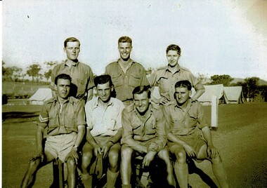
Photograph, Vernon Taylor and mates
... Tatura Irrigation & Wartime Camps Museum 49 Hogan Street Tatura the-murray Photograph taken in the Army Camp at Tatura Internment Camp. vernon taylor piece of paper attached on back: Vernon Castle Taylor V46278 served 1/9/1940 to 5/4/1946 discharge S04258 *top right hand* Sepia photograph of 7 men (3 standing and 4 sitting) with Army huts in the background. ...Photograph taken in the Army Camp at Tatura Internment Camp.Sepia photograph of 7 men (3 standing and 4 sitting) with Army huts in the background.piece of paper attached on back: Vernon Castle Taylor V46278 served 1/9/1940 to 5/4/1946 discharge S04258 *top right hand*vernon taylor -
Tatura Irrigation & Wartime Camps Museum
Book, German in a Nutshell, 1967
... Tatura Irrigation & Wartime Camps Museum 49 Hogan Street Tatura the-murray Understanding the German language Paperback book. Title and photo of German castle on front German in a Nutshell Book Funk and Wagnalls Henry Regensteiner Ph. ...Understanding the German languagePaperback book. Title and photo of German castle on front -
Tatura Irrigation & Wartime Camps Museum
Book, Life and Times of A E Castles, 2001
... Tatura Irrigation & Wartime Camps Museum 49 Hogan Street Tatura the-murray Book contains details of buildings, structures and renewed interest in A E Castles as engineer and architect of Deakin Shire and events of 100 years ago. ...Book contains details of buildings, structures and renewed interest in A E Castles as engineer and architect of Deakin Shire and events of 100 years ago.White cover, blue and black lettering. Copy of Kyabram Hotel on front cover, group of men under verandah.a e castles, deakin shire buildings, a e castles engineer, a e castles architect -
Tatura Irrigation & Wartime Camps Museum
Document, Tatura and other Water Towers
... Tatura Irrigation & Wartime Camps Museum 49 Hogan Street Tatura the-murray Information as to the construction of Tatura and other Water Towers, designed by Arthur Castles. ...Information as to the construction of Tatura and other Water Towers, designed by Arthur Castles. -
Dutch Australian Heritage Centre Victoria
tourists bicycle pennants, mid 20th century
... Kamper Boerderij - A farm providing camping grounds. 2. Kasteel Beusdael - The Beusdael Castle 3. Wingbergermoelen - Wingberger Mill Also a little tent beneath the name of the town, with refers to the camping holiday. ...Kamper Boerderij - A farm providing camping grounds. 2. Kasteel Beusdael - The Beusdael Castle 3. Wingbergermoelen - Wingberger Mill Also a little tent beneath the name of the town, with refers to the camping holiday. ...TourismHow people went on holiday. A memento of simple holidays. The tradition of camping as the holiday of choice.calico, triangular pennant. One edged in blue, the other in red.4089.R1 - blue edged pennant, showing the tourist sites around a place called Epen in the southern part of the province of Limburg. This is known because the name of the town is in large red letters. Three locations shown 1. Kamper Boerderij - A farm providing camping grounds. 2. Kasteel Beusdael - The Beusdael Castle 3. Wingbergermoelen - Wingberger Mill Also a little tent beneath the name of the town, with refers to the camping holiday. Also a maker's mark on the pennant, a small triangle with the letters L, A & B within it. 4089.R2 - red edged pennant, showing the area around Vaals in Limburg province, the name is in large red letters. The scene shows the meeting point between the Netherlands, Germany & Belgium - "Drie Landen Punt" (Three Country Meeting Point) Also shows the height of the viewing point (193m), as well showing other features including: - Hotel Bellevue - Uitzichttoren - viewing tower - Panorama Aken - Panorama of Aachen, Germany - Spoorbrug-Moresnet - Railwaybridge-Moresnet in Belgium. Small makers mark. Black triangle, possible the same as that shown in the other pennant, though obscured. -
 Dandenong/Cranbourne RSL Sub Branch
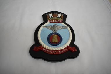
Plaque - HMAS Bataan Plaque, Circa 1950s
... camps. Shield is inscribed with BATAAN at top and the motto UNQUIBUS ET ROSTRO below. Wooden plaque with metal shield attached. Shield shows eagle with out spread wings standing on dark blue wreath with gold castle inside on light blue background. ...The Battle of Bataan is famous in history as one of the last stands of American and Filipino soldiers before they were overwhelmed by the Japanese Forces in WW11. The Bataan Death March was named after the province where the infamous March started. Approximately 75,000 Filipino and American troops on Bataan were forced to make an arduous 65 mile march to the prison camps.Wooden plaque with metal shield attached. Shield shows eagle with out spread wings standing on dark blue wreath with gold castle inside on light blue background.Shield is inscribed with BATAAN at top and the motto UNQUIBUS ET ROSTRO below. -
 Ballarat Heritage Services
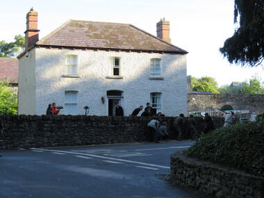
Photograph - Digital Photograph, Dorothy Wickham, Filming Fingal's Finest Day, Malahide Castle, 2016, 09/2016
... Set in 260 acres the castle is only 10 minutes from Dublin airport. https://www.malahidecastleandgardens.ie/ According to wikipedia See https://en.wikipedia.org/wiki/Easter_Rising#Fingal In Fingal (or north County Dublin), about 60 Volunteers mobilised near Swords. They belonged to the 5th Battalion of the Dublin Brigade (also known as the Fingal Battalion), and were led by Thomas Ashe and his second in command, Richard Mulcahy. Unlike the rebels elsewhere, the Fingal Battalion successfully employed guerrilla tactics. They set up camp...Set in 260 acres the castle is only 10 minutes from Dublin airport. https://www.malahidecastleandgardens.ie/ According to wikipedia See https://en.wikipedia.org/wiki/Easter_Rising#Fingal In Fingal (or north County Dublin), about 60 Volunteers mobilised near Swords. They belonged to the 5th Battalion of the Dublin Brigade (also known as the Fingal Battalion), and were led by Thomas Ashe and his second in command, Richard Mulcahy. Unlike the rebels elsewhere, the Fingal Battalion successfully employed guerrilla tactics. They set up camp ...Generations of the Talbot family have called Malahide Castle home. They played significant roles in Irish political and social life. Set in 260 acres the castle is only 10 minutes from Dublin airport. https://www.malahidecastleandgardens.ie/ According to wikipedia See https://en.wikipedia.org/wiki/Easter_Rising#Fingal In Fingal (or north County Dublin), about 60 Volunteers mobilised near Swords. They belonged to the 5th Battalion of the Dublin Brigade (also known as the Fingal Battalion), and were led by Thomas Ashe and his second in command, Richard Mulcahy. Unlike the rebels elsewhere, the Fingal Battalion successfully employed guerrilla tactics. They set up camp and Ashe split the battalion into four sections: three would undertake operations while the fourth was kept in reserve, guarding camp and foraging for food. The Volunteers moved against the RIC barracks in Swords, Donabate and Garristown, forcing the RIC to surrender and seizing all the weapons. They also damaged railway lines and cut telegraph wires. The railway line at Blanchardstown was bombed to prevent a troop train reaching Dublin. This derailed a cattle train, which had been sent ahead of the troop train. The only large-scale engagement of the Rising, outside Dublin city, was at Ashbourne. On Friday, about 35 Fingal Volunteers surrounded the Ashbourne RIC barracks and called on it to surrender, but the RIC responded with a volley of gunfire. A firefight followed, and the RIC surrendered after the Volunteers attacked the building with a homemade grenade. Before the surrender could be taken, up to sixty RIC men arrived in a convoy, sparking a five-hour gun battle, in which eight RIC men were killed and 18 wounded. Two Volunteers were also killed and five wounded, and a civilian was fatally shot. The RIC surrendered and were disarmed. Ashe let them go after warning them not to fight against the Irish Republic again. Ashe's men camped at Kilsalaghan near Dublin until they received orders to surrender on Saturday. The Fingal Battalion's tactics during the Rising foreshadowed those of the IRA during the War of Independence that followed. Volunteer contingents also mobilised nearby in counties Meath and Louth, but proved unable to link up with the North Dublin unit until after it had surrendered. In County Louth, Volunteers shot dead an RIC man near the village of Castlebellingham on 24 April, in an incident in which 15 RIC men were also taken prisoner.filming, fingal's finest day, malahide castle, ireland