
Showing 13 items matching "charting the weather"
-
 Moorabbin Air Museum
Book - Meteorology, Meteorology for Glider Pilots
... ...Charting the weather...Meteorology Pressure & wind Nature of the air Introducing the clouds Frost/fog & smoke Warm & cold fronts Jet streams & pressure changes Depressions Anticyclones Charting the weather Airflow at low levels Sea breezes The tephigram Convection Shower/Thunder & lightning Thermal soaring Lee waves Wave soaring The altimeter Overview of meteorology for glider pilots, circa 1961 Meteorology for Glider Pilots Book Meteorology ...Overview of meteorology for glider pilots, circa 1961non-fictionOverview of meteorology for glider pilots, circa 1961pressure & wind, nature of the air, introducing the clouds, frost/fog & smoke, warm & cold fronts, jet streams & pressure changes, depressions, anticyclones, charting the weather, airflow at low levels, sea breezes, the tephigram, convection, shower/thunder & lightning, thermal soaring, lee waves, wave soaring, the altimeter -
 Flagstaff Hill Maritime Museum and Village
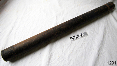
Container - Chart Case, ca 19th century
... "Flagstaff Hill c/ J Lindsay" This chart case is an example of maritime chart storage used in colonial times to protect charts and maps from the weather and to store them is an easily accessible was. flagstaff hill warrnambool shipwrecked-coast flagstaff-hill flagstaff-hill-maritime-museum maritime-museum shipwreck-coast flagstaff-hill-maritime-village chart case navigation chart storage Chart case, black painted metal cylindrical container with caps on both ends. ...Black painted metal cylindrical container. Label attached at one end with inscription. "Flagstaff Hill c/ J Lindsay"This chart case is an example of maritime chart storage used in colonial times to protect charts and maps from the weather and to store them is an easily accessible was. Chart case, black painted metal cylindrical container with caps on both ends.flagstaff hill, warrnambool, shipwrecked-coast, flagstaff-hill, flagstaff-hill-maritime-museum, maritime-museum, shipwreck-coast, flagstaff-hill-maritime-village, chart case, navigation, chart storage -
Federation University Historical Collection
Document - Document - Letter, Ballarat Junior Technical School: Letters relating to equipment to establish a practice weather-observation station. 1952
... weather-observing station as part of general science. Mr McLachlin in Ballarat will guide the school as to method, procedure, records, etc List of equipment on loan - Stevenson Screen, maximum and minimum thermometers, wet and dry bulb thermometers, 8" rain gauge, cloud chart, instructions for reductions of barometer readings, weather code for transmission, record book. ...weather-observing station as part of general science. Mr McLachlin in Ballarat will guide the school as to method, procedure, records, etc List of equipment on loan - Stevenson Screen, maximum and minimum thermometers, wet and dry bulb thermometers, 8" rain gauge, cloud chart, instructions for reductions of barometer readings, weather code for transmission, record book. ballarat junior technical school head master l garner h b selby weather bureau weather station observations fortin barameter regnault vapour pressure apparatus stevenson screen maximum thermometer minimum thermometer bulb thermometers rain gauge instructions weather code record book .1: Letterhead for H B Selby & Co Pty Ltd - Black and red inks Signature of V T Parkinson, Manager 2 Cream pages, typed Ballarat Junior Technical School: Letters relating to equipment to establish a practice weather-observation station. 1952 Document Document - Letter ....1: Letter from H B Selby & Co Pty Ltd re the order for a Fortin Barameter. Asking for arrangement for Staff member to collect as it is very fragile. The glassware for the Regnault Vapour pressure Apparatus not previously sent has been forwarded. .2: Letter from the school to The Director Weather Bureau Melbourne. Outlines establishing a weather-observing station as part of general science. Mr McLachlin in Ballarat will guide the school as to method, procedure, records, etc List of equipment on loan - Stevenson Screen, maximum and minimum thermometers, wet and dry bulb thermometers, 8" rain gauge, cloud chart, instructions for reductions of barometer readings, weather code for transmission, record book. 2 Cream pages, typed .1: Letterhead for H B Selby & Co Pty Ltd - Black and red inks Signature of V T Parkinson, Managerballarat junior technical school, head master, l garner, h b selby, weather bureau, weather station, observations, fortin barameter, regnault vapour pressure apparatus, stevenson screen, maximum thermometer, minimum thermometer, bulb thermometers, rain gauge, instructions, weather code, record book -
 Flagstaff Hill Maritime Museum and Village
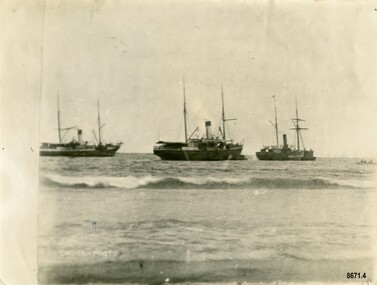
Photograph - Steamers - Julia Percy, Dawn and Coorong, Chuck Photo Ballarat, Circa 1885
... The crew (six men) were able to get away in a small boat with a compass, chart and few candles. They were "excessively cold from exposure to the weather" when the S. ...The crew (six men) were able to get away in a small boat with a compass, chart and few candles. They were "excessively cold from exposure to the weather" when the S. ...This photograph was one of ten photographs donated to Flagstaff Hill Maritime Museum and Village by Fred Trewartha. Frederick John Fox Trewartha (Fred) was a well-known Warrnambool businessman. He was born in Beeac near Geelong in 1920 and came to Warrnambool with his family as a very young child. He was apprenticed to his father John, as a saddler and later opened his own shop on Raglan Parade. He then moved into working with tarpaulins and canvases for the trucking industry. Fred was keenly interested in photography (and was a member of the Warrnambool Cine Club), yachting and boat building. He kept his yacht moored at Port Fairy for many years and participated in sailing events locally and interstate. He also built boats with his sons. He had the opportunity to meet many older sailors and it's thought this photo (and others in the set) may have been given to him by one of these men. Fred Trewartha died in 2016 in Warrnambool. Shipping was the cheapest and most practical means of carrying produce and goods during the period 1840-1890. Regular domestic steamer services commenced in the Warrnambool district in the late 1850’s and by 1870 the passenger trade was booming. Four coastal traders made regular stops at Warrnambool in the 1880's - S. S. Julia Percy, S. S. Dawn, S. S. Nelson and S. S. Casino. The S.S. Julia Percy (later named Leeuwin) was an iron passenger-cargo steam ship built in 1876. At one point in time the Julia Percy would sail from Warrnambool to Melbourne every Friday and return from Melbourne to Warrnambool every Tuesday. The cost of a return ticket for a Saloon Fare was £1.0.0. The Julia Percy was built in Glasgow by Thomas Wingate & Company, Whiteinch, in 1876 for the Warrnambool Steam Packet Company, which commissioned it for trade in Victoria’s western district. It was first registered in Warrnambool, Victoria in 1876. Two steamships, the Julia Percy and the Nelson, collided on 25th December 1881. The Julia Percy was at that time owned by its first owners, the Warrnambool Steam Packet Company, and she sailed under the command of Captain Chapman. It had left Melbourne the evening of 24th December, with about 150 passengers, sailing in fine weather through Port Phillip Heads around 9pm. It was headed for Warrnambool, Belfast (now named Port Fairy) and Portland. The Julia Percy was off Apollo Bay when Captain Chapman was woken by the ship’s whistle after midnight, the steamer Nelson being on a collision course with the Julia Percy. The Nelson struck Julia Percy midship. Boats were lowered from the ship (apart from a damaged lifeboat) and about 30-40 of the passengers boarded the Nelson. The engine room and the forehold were checked and found clear of water. The company manager, Mr. Evans, had been on the Nelson, so he boarded and inspected the Julia Percy and the decision was made to continue on to Warrnambool with the passengers as there appeared to be no immediate danger. However, Captain Thomas Smith said the Nelson was taking on water, so Julia Percy followed it for about an hour towards Melbourne on standby in case of need. Then Julia Percy turned around towards Warrnambool again. Shortly afterwards the Nelson turned to follow her, the ships stopped and passengers were returned to Julia Percy, and three from Julia Percy boarded the Nelson. Both ships proceeded on their way. Julia Percy passed Cape Otway light afterwards, signaling that there had been a collision. It was discovered later that one of the passengers was missing, then thought to have boarded the Nelson but later thought to have fallen into the sea and drowned while trying to jump from Julia Percy to Nelson. There had been 3 tickets purchased under the same name of that passenger “Cutler”; a father, son and friend named Wordsworth, which had caused quite some confusion. No further mishap occurred to either ship and both the Julia Percy and the Nelson reached their destinations safely. An enquiry was instigated by the Victoria Steam Navigation Board regarding the cause of the accident between the two steamships, in connection with the death of Cutler who was supposed to have lost his life by the collision. The enquiry resulted in Captain Thomas Smith having his master's certificate suspended for six months. The Julia Percy changed hands several times. Its next owner was the Western Steam Navigation Co (1887), managed by Mr. T.H. Osborne (the company’s office was on the corner of Timor and Liebig Streets - its north-western wall is now part of the current Warrnambool Regional Art Gallery.) The Melbourne Steamship Co became the next owners (1890), followed by William Howard Smith and Sons (1901) for use in Queensland coastal trades and then it was bought by George Turnbull in 1903 and used for local mail contract in Western Australia. The Julia Percy was sold to the Melbourne Steamship Company Ltd. (1906) and re-named the “Leeuwin” but continued in her Western Australian coastal run. It was converted into a coal hulk in Melbourne in 1910 as a result of damaged caused when it was driven against the jetty at Dongara during a gale. The ship was eventually dismantled and scuttled off Port Phillip Heads on 28 December 1934. The steamship "Dawn" was a 522-ton coastal trader built in 1876 and the vessel operated around the Victorian west coast from 1877 until 1898 for the Portland & Belfast Steam Navigation Co. sailing between Melbourne and Portland, via Warrnambool. The vessel was then owned in October 1885 by the renamed company, Belfast & Koroit Steam Navigation Co., until March 1896 when its ownership moved to W Howard Smith & Sons Ltd. This Melbourne company used the ship to service most ports around Australia. Captain F. Chapman took over from Captain Jones and served on the SS Dawn from 1898 until 1900 when he took command of the SS Casino. On September 4th 1880, the three masted clipper ship, "Eric the Red" struck Otway Reef, near Cape Otway. The S. S. Dawn, under the command of Captain Jones, was returning to Warrnambool from Melbourne, its sailing time different to its usual schedule. The provedore of the Dawn, Benjamin Lear, heard cries of distress coming through the portholes of the saloon. He gave the alarm and the engines were stopped. Cries could be heard clearly, coming from the land. Captain Jones sent out crew in two boats, and fired off rockets and blue lights to illuminate the area. They picked up the three survivors who were in the long boat from "Eric the Red". Two men were picked up out of the water, one being the owner’s son who was clinging to floating kerosene boxes. At daylight the Dawn then rescued the 18 men from the floating portion of the deckhouse, which had drifted about 4 miles from where they’d struck the reef. Shortly after the rescue the deckhouse drifted onto breakers and was thrown onto rocks at Point Franklin, about 2 miles east of Cape Otway. Captain Jones had signalled to Cape Otway lighthouse the number of the Eric the Red and later signalled that there was a wreck at Otway Reef but there was no response from the lighthouse. The captain and crew of the Dawn spent several more hours searching unsuccessfully for more survivors, even going back as far as Apollo Bay. On board the Dawn the exhausted men received care and attention to their needs and wants, including much needed clothing. Four men (three crew and one passenger) died. A week after the shipwreck, the Australian Government had also conveyed its thanks to the Captain and crew of the S.S. Dawn - “Captain Griffith Jones, S.S. Dawn, The Hon. Mr Clark desires that the thanks of the Government should be conveyed to you for the prompt, persevering and seamanlike qualities displayed by you, your officers and crew in saving the number of lives you did on the occasion referred to. The Hon. The Commissioner has also been pleased to award you a souvenir in commemoration of the occasion, and a sum of 65 pounds to be awarded to your officers and crew according to annexed scale. I am, &c, W Collins Rees, for and in the absence of the Chief Harbour Master.” The Awards are as follows: - Crew of DAWN'S lifeboat-Chief Officer, Mr G. Peat, 15 pounds; boat's crew-G. Sterge, A.B., 5 pounds; T. Hammond, A.B., 5 pounds; J. Black, A.B., 5 pounds; H. Edwards, A.B., 5 pounds. Dinghy's Crew-Second Officer, Mr Christie, 10 pounds; boat's crew -F. Lafer, A.B., 5 pounds; W. Johnstone, A.B., 5 pounds; Mr Lear, provedore, 5 pounds; Mr Dove, purser, 5 pounds. Captain Jones receives a piece of plate. (from “Wreck of the ship Eric the Red” by Jack Loney). Medals of Bravery were awarded to the Captain and crew of the S.S. Dawn by the President of the United States, through the Consul-general (Mr Oliver M. Spencer), in July 1881 “ … in recognition of their humane efforts in rescuing the 23 survivors of the American built wooden sailing ship, the Eric the Red, on 4th September 1880.” The men were also presented with substantial monetary rewards and gifts. The city of Warrnambool’s care of the survivors was also mentioned by the President at the presentation, saying that “the city hosted and supported the crew ‘most graciously’. The Medal of Bravery awarded to Nelson Johnson is in the collection at Flagstaff Hill Maritime Museum and Village in Warrnambool. Prior to 1882, and the arrival of the S. S. Casino, the "Dawn" was the only steamer to be able to navigate up the Moyne River at Port Fairy and unload at the wharf. The other regular steamers had to anchor in the bay instead. In February 1891 (as reported in The Age newspaper) the "Dawn" became the first vessel to berth alongside the newly completed Warrnambool Breakwater. The occasion was celebrated with a number of prominent townspeople assembling on board to "participate of a glass of wine". In 1895 the owners of the S.S. Dawn, the Portland and Belfast Steam Navigation Co., wound up and sold out to the Belfast Company who took over the Dawn for one year before selling it to Howard Smith. It took over the Melbourne to Warrnambool run in 1906 when the S. S. Flinders was sold. The S. S. Dawn was condemned and sunk in Suva in 1928. The State Library of Victoria has a lithograph in its collection depicting the steamer Dawn and the shipwrecked men, titled. "Wreck of the ship Eric the Red, Cape Otway: rescue of the crew by the Dawn". The third ship depicted in the photograph was thought to be the S. S. Coorong but there was a question mark next to its name. The photograph was thought to have been taken in 1885 and it's possible the S.S. Coorong was working in Clarence River, N. S. W. by this time. The steamer "Coorong" was built in 1862 by J. G. Lawrie of Glasgow. It was an "iron screw" steamer of 304 tons. It had many owners including Joseph Darwent of Adelaide (1863 - 1871), McMeckan Blackwood and Company, Melbourne (1871 - 1877), Mount Gambier Steamship Company Ltd. (1877 - 1881). William Whineham, Port Adelaide (1882), John See and Company, Sydney (1884 - 1892) and the North Coast Steam Navigation Company Ltd, Sydney (1892 - 1910). In 1911 it was hulked in Sydney Harbour and in 1921 it was being used as a coal hulk at Sydney. It had been originally imported into South Australia for the Port Augusta trade (primarily transporting goods needed by the early settlers) however the owners recognized that it had too much space for that purpose, so it was moved to work on the Adelaide to Melbourne line. Its passenger accommodation was enlarged and it enjoyed a "first class reputation" and by 1874 had made 313 voyages between Melbourne and Adelaide. Its captains included Captain McLean, Captain Ashton and Captain Dowell. In 1867, when 25 miles west of Cape Otway, while travelling from Adelaide to Melbourne, it came across the crew of the schooner "Black Watch" who had abandoned ship after it began quickly taking on water. The crew (six men) were able to get away in a small boat with a compass, chart and few candles. They were "excessively cold from exposure to the weather" when the S. S. Coorong picked them up. In 1877 the Coorong ran aground when entering the Outer Harbour at Adelaide (but was not damaged) and in 1882 it was stranded (for a short time) near Curdies Inlet (Victoria) with some slight damage to its bottom plates. Note - A ship with the same name "Coorong" (a coal carrying barque) was often on the Newcastle / Wollongong to Adelaide route also stopped several times in Warrnambool in the mid 1880's. The photograph has the label "Chuck Photos" printed on the front. Thomas Foster Chuck (born 1826 in London) was a photographer and entrepreneur who arrived in Victoria in 1861. The following year he produced and toured a "Grand Moving Diarama" of dramatic painted scenes from the Burke and Wills expedition. By 1866 he had established a photography studio in Daylesford and later he returned to Melbourne where he opened a studio in the Royal Arcade. In 1874 a collection of Chuck's photographs won a gold medal at the Annual International Exhibition in London. Throughout the 1870's he took over 700 individual photographs of prominent citizens for his historical photographic montage titled "Historical Pictures of the Explorers and Early Colonists of Victoria" which is now in the collection of the National Library of Australia. By 1888 he had sold his Melbourne studio and had established a studio in Ballarat (with his son Thomas Henry Chuck). In 1886 they produced an album titled "Warrnambool and District 1886, Western Hotel - J. Fox proprietor" containing over sixty large photographs of local coastal scenes and seascapes, for the use of patrons of the Western Hotel. This photo (of the three steamers in Lady Bay) was taken at this time and is in the album. Thomas Chuck died on December 7th, 1898, in Albert Park, Melbourne and his son Thomas Henry continued to operate the photography studio in Ballarat into the 1920's.This photograph is a significant record of several of the well-known coastal traders (S. S. Julia Percy, S. S. Dawn and possibly S. S. Coorong) that sailed along the southwest coast of Victoria for many years - transporting goods and passengers between Melbourne and Warrnambool in the 1880's. They are also significant in the role they played in the history of Warrnambool and the other coastal ports they visited as well as being examples of the dangers and hazards associated with navigating the waters along the southern coast of Australia. It is also a good example of a photograph taken by a well-known and significant photographer of that era.Black and white photograph of three steam ships anchored in Lady Bay, Warrnambool. They each have a funnel and two masts and are side on to the beach. A small rowboat with a crew can be seen on the far right. The words "CHUCK-PHOTO" are on the bottom left of the photograph. On the back of the photograph is the name and telephone number of the donor (handwritten in black ball point pen) and the names of the three steamships and date written in uppercase letters in dark blue ink. There is a four-figure number stamped in the centre of the back.Front - "CHUCK-PHOTO" Back - Name of donor and telephone number "6944" "JULIA PERCY, DAWN & KOORONG(?) IN LADY BAY 1885"flagstaff hill maritime museum and village, warrnambool, great ocean road, fred trewartha, s. s. julia percy, s. s. dawn, s. s. nelson, s. s. casino, leeuwin, steamer, steamship, coastal trader, warrnambool steam packet company, captain chapman, victorian steam navigation board, western steam navigation company, melbourne steamship company, william howard smith and sons, portland and belfast steam navigation company, w howard smith and sons ltd, eric the red, captain jones, medal of bravery, rescue, moyne river, warrnambool breakwater, lady bay, s. s. coorong, mount gambier steamship company, black watch, thomas foster chuck, chuck photos, chuck photography -
 Flagstaff Hill Maritime Museum and Village
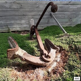
Equipment - Anchor, John Trotman, 1852 to early 1900s
... weather. This mooring line appears as a dotted line on a 1890 chart of Lady Bay approved by Lieutenant Stanley of the British Admiralty. ...weather. This mooring line appears as a dotted line on a 1890 chart of Lady Bay approved by Lieutenant Stanley of the British Admiralty. ...This Trotman’s pattern stock anchor is the southernmost anchor displayed in Flagstaff Hill’s Anchor Graveyard. Patented by John Trotman in 1852, this robust design was used on merchant ships and became known for its practical efficiency. Around midday on 15 April 2001, in Lady Bay, Warrnambool, Birdon Dredging crews raised this anchor from the seabed. Company spokesperson Steve Walker explained that the team was hired to dredge the harbour and discovered the anchor, still attached to its long chain, when the chain became tangled in the cutter blade of their dredging equipment. Once the anchor had been lifted onto the Breakwater, a front-end loader moved it onto a truck for delivery to Flagstaff Hill Maritime Museum and Village. Howard Nichol, the Museum Manager at the time, estimated that the anchor could be up to 130 years old. Former Museum Manager and diver Peter Ronald later identified it as a Trotman’s type, like those used on several major wrecks in the region. According to Nichol, museum staff believed this anchor may have been one of a pair used to secure a mooring designed to catch drifting vessels and prevent ships from washing onto the sandbar or drifting out to sea in rough weather. This mooring line appears as a dotted line on a 1890 chart of Lady Bay approved by Lieutenant Stanley of the British Admiralty. The anchor’s location matches a point marked on that chart, and the length of its chain supports the theory. Nichol noted that the chart is a detailed survey of the bay, showing two anchors with buoys at either end, with about one hundred yards of chain stretched between them. Before the building of the Breakwater, the bay was especially treacherous, so ships would anchor there and use the chain as a safeguard. About Trotman’s Anchors In the mid-19th century, the Admiralty sought an anchor design with greater holding power. To assess the strengths of the leading designs, it appointed the Committee of 1852 on Anchors. Among the anchors reviewed, the Trotman’s pattern anchor received the highest rating. The Trotman’s anchor resembles the Admiralty pattern but includes pivoting arms that move as the anchor settles. As it takes hold, the upper fluke folds back against the shank, allowing the anchor to sit lower and reducing the risk of the chain, cable, or rope becoming tangled. A fitting at the top of the shank also allows the chain to be quickly released if necessary. This Trotman’s anchor is significant as a part of the maritime history of the Port of Warrnambool regardless of whether it belonged to one of the 29 ships that were stranded or wrecked in Lady Bay. The anchor is connected to the many attempts to maintain Warrnambool as a safe and manageable port, including the various plans for the construction of the Breakwater.Anchor: an iron Trotman’s pattern style with a rectangular-section shank that is wider in the middle and has a base that extends on two opposite sides in a ‘fork prong’ manner. A crescent-shaped, double-ended arm is fitted into the base of the shank with a bolt, enabling it to pivot. Each arm has a fluke in the shape of an upward palm with an attached metal plate that forms a horn at the back of the palm. A long, round-section pipe is fitted to the top of the shank at 90 degrees to the arms; one side has an elbow bend parallel to the arms, and both ends have an attached metal sphere. The pivoting ring at the top of the shank can be lifted for a quick release of the chain.flagstaff hill, warrnambool, maritime village, maritime museum, shipwreck coast, great ocean road, anchor, mooring, trotman, lady bay, breakwater, admiralty, ship equipment, stock anchor, john trotman, 1852 patent, 2001, birdon dredging, steve walker, howard nichol, peter ronald, british admiralty, lieutenant stanley, committee of 1852 on anchors -
 Flagstaff Hill Maritime Museum and Village
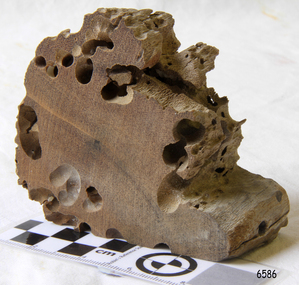
Memorabilia - Wood Sample, about 1871
... At 1 am on 4 September the weather was hazy with a moderate north-westerly wind, Captain Jacques Allen had all sail set except for the mizzen-royal and the cross jack sails doing 8 knots, and was steering by the light to keep 5-6 miles offshore and clear of Otway Reef. Returning to the deck after consulting his charts...At 1 am on 4 September the weather was hazy with a moderate north-westerly wind, Captain Jacques Allen had all sail set except for the mizzen-royal and the cross jack sails doing 8 knots, and was steering by the light to keep 5-6 miles offshore and clear of Otway Reef. Returning to the deck after consulting his charts ...The American wooden ship Eric the Red was named after the Icelandic Viking Eric 'the Red-Haired' Thorvaldsson, who was the first European to reach the shores of North America in 980 A.D. The ship Eric the Red was owned by the Sewall family of Bath, Maine, between 1873 and 1877 it operated in the coal trade between Britain and America. It then operated on the South American guano/ nitrates trade, before again trading between Europe and New York. On this voyage the Eric the Red had been chartered to carry a full cargo of American merchandise including many exhibits bound for the international exhibition to be held in Melbourne in 1880. Eighty-five days out from New York with 23 crew and two passengers, the Eric the Red approached Cape Otway nearing the end of its long voyage. At 1 am on 4 September the weather was hazy with a moderate north-westerly wind, Captain Jacques Allen had all sail set except for the mizzen-royal and the cross jack sails doing 8 knots, and was steering by the light to keep 5-6 miles offshore and clear of Otway Reef. Returning to the deck after consulting his charts the ship bumped as it ran onto the Otway Reef. It struck a second time and then a heavy sea carried away the wheel ropes and the man at the wheel. A third bump carried away the rudder, and shortly after this the ship completely broke up - within twelve minutes it had disappeared but for floating wreckage and cargo. Captain Jacques Allen recounted that: "The mizzen topmast fell with all the rigging, but strange to say, not a man was hurt by it, although they were all standing about. As soon as I found out there was no hope I said to Ned Sewell, the owner's son, and the third mate on board "Stick to me, and hang on to this mizzen mast". I peeled off everything I had on except my drawers thinking I would be able to swim better without my clothes; and Sewell and myself, clinging to the mast, were washed overboard...It was a fearful sea; I have never seen anything like it". Attempting to swim to a more substantial raft of wreckage, and losing touch with young Sewell in the process, Captain Allen struck out: " Just as I left the spar my drawers got down my legs, and entangled them, and down I went. I managed to clear one of my legs and on coming up I managed to get hold of some floating timber. There was a clear space of water between this timber and the deck, except for the spare royal yard, and I again started, but the surf struck me and I went over and over. I managed to get hold of the spare yard, and after holding on to it for some time I managed to get to the deck. When I was pulled on to it I could not move, being so numb and cramped with the cold. The men had some blankets and other things which they had got from the passengers' room in the deck house, and they wrapped me in these. Shortly after I got onto the wreck we made out the steamer's lights, and as soon as she was within hearing distance the men haled. This must have been about half-past four the Captain of the Dawn sent two of his boats to cruise about, and at daylight, they picked us up off the wreck. We had drifted about four miles from the reef where the ship struck, all those who were rescued were more or less bruised. One man had two or three ribs broken, and another had some fingers crushed off. My left foot is very much hurt, and I am black and blue from head to foot. I never knew such ten minutes as that of the wreck, and I thought the time had come for me to 'hand in my checks'. The ship was worth about £15,000, and neither it nor the freight was insured one dollar". (Argus 14/9/1880). Three of the crew and one of the passengers had been swept away and drowned. Fortunately for those clinging to the remains of the shattered hull and floating wreckage, the steamer SS Dawn passed close by and the crew heard the distressed cries of the survivors. Boats were lowered and the survivors were rescued. The Dawn stayed in the area for several hours searching for more survivors. One body was found washed up at Cape Otway and was buried in the lighthouse cemetery. The captain and crew of the Dawn later received rewards and thanks from the United States consul for their efforts. The hull and cargo were sold for £410, and large rafts of floating wreckage and cargo washed up all over the Victorian coast. A section of the hull lies buried in the sand at the Parker River beach, an anchor is on the rocks at Point Franklin, a second anchor is on display at the Cape Otway lighthouse and parts of the ship are on display at Bimbi Park and the Apollo Bay museum. Various wreckage is located in a concentration off Point Franklin, but suitable diving conditions are rare due to waves and strong currents. At the time of the wreck parts of its were salvaged and used in the construction of houses and sheds around Apollo Bay, including Milford House (since burnt down in bush fires), which had furniture and fittings from the ship, and the dining room floor made out of its timbers. A ketch the Apollo was also built from its timbers and subsequently used in Tasmanian waters.The Eric the Red is historically significant as one of Victoria's major 19th-century shipwrecks. The wreck led to the provision of an additional warning light placed below the Cape Otway lighthouse to alert mariners to the location of Otway Reef. The site is archaeologically significant for its remains of a large and varied cargo and ship's fittings being scattered over a wide area. The site is recreationally and aesthetically significant as it is one of the few sites along this coast where tourists can visit identifiable remains of a large wooden shipwreck and for its location set against the background of Cape Otway, Bass Strait, and the Cape Otway lighthouse. (Victorian Heritage Database Registration Number S 239, Official Number 8745 USA) Wood sample from the wreck of the ship Eric the Red the wood is dark in colour and is very light in weight. Noneflagstaff hill, warrnambool, shipwrecked-coast, flagstaff-hill, flagstaff-hill-maritime-museum, maritime-museum, shipwreck-coast, flagstaff-hill-maritime-village, shipwreck-artefact, eric-the-red, zaccheus-allen, sewall, 1880, melbourne-exhibition, cape-otway, otway-reef, wood-sample, s.s.-dawn -
 Mission to Seafarers Victoria
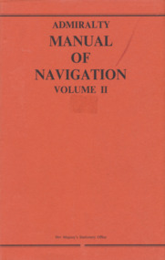
Book, Her Majesty's Stationery Office, Admiralty Manual of Navigation Vol.2, 1973
... The first chapters are mainly concerned with distances, courses, tracks and charts; then various methods of obtaining position lines and positions from astronomical observations are explained, including a rapid. method in the last chapter. The volume also contains an outline of meteorrology and weather ...This volume of the Admiralty Manual of Navigation describes off-shore navigation - the safe conduct of a ship across the open sea where, in general, hearings of objects on land cannot be obtained except by means of radio waves (i.e. using radio fixing aids). The first chapters are mainly concerned with distances, courses, tracks and charts; then various methods of obtaining position lines and positions from astronomical observations are explained, including a rapid. method in the last chapter. The volume also contains an outline of meteorrology and weather forecasting.329 pages, illustrated, navy blue linen cover and red paper dust jacket.non-fictionThis volume of the Admiralty Manual of Navigation describes off-shore navigation - the safe conduct of a ship across the open sea where, in general, hearings of objects on land cannot be obtained except by means of radio waves (i.e. using radio fixing aids). The first chapters are mainly concerned with distances, courses, tracks and charts; then various methods of obtaining position lines and positions from astronomical observations are explained, including a rapid. method in the last chapter. The volume also contains an outline of meteorrology and weather forecasting.howard timbury, first fleet fellowship victoria, interest group, navigation, education -
 Kiewa Valley Historical Society
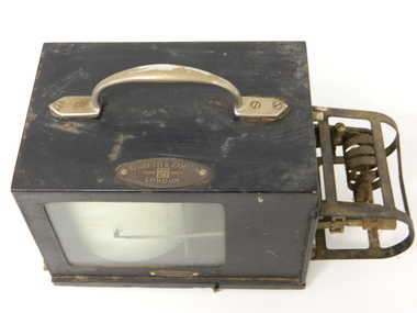
Barometer Anoroid, circa mid to late 1900's
... Weather records were kept of temperature, wet-bulb temperature, wind direction, speed and barometric pressures. To record barometric pressure a meter was devised with a clockwork mechanism which took one week to do a revolution. A chart ...This barometer was part the hydrology and forestry groups working within the SEC Vic Hydro Scheme from the initial appraisal review long before any construction began in the 1940's. The river flows and rainfall patterns had to be established before any construction of holding dams or tunneling could commence. This barometer is very relevant to the Kiewa Valley history because it presents the high degree of professional and technical information required at the time before implementing the "Scheme" upon the virgin alpine region and its effects upon the "natural" flows of the rivers within the Kiewa Valley. Time since the start of the project has verified the use of instruments such as this barometer and the information gained from its use that the success of any large impact upon a sensitive environment requires a thorough and systematic study before implementation. Weather records were kept of temperature, wet-bulb temperature, wind direction, speed and barometric pressures. To record barometric pressure a meter was devised with a clockwork mechanism which took one week to do a revolution. A chart was fitted to a drum and had an ink pen shaped like a little shovel. The shovel was filled with ink and was checked daily. To calibrate the barometer it was sent to the Melbourne General Post Office to be compared against the one there (at sea level). After calibration it was sent back to the Bogong Camp.On plaque on top side."NEGRETTI & ZAMBRA" underneath this and in smaller print "TRADE MARK" below this "LONDON" On the bottom and in small print "HOBART DUFFPty Ltd COLLINS HOUSE MELBOURNE C1"kiewa hydro electricity scheme, victorian state electricity commission, transformers, resistors, barometers -
B-24 Liberator Memorial Restoration Australia Inc
Map - Silk Map of South West Pacific Ocean, Ocen Currents and Surface winds of the West pacific Area May-October
... OCEAN CURRENTS AND SURFACE WINDS FOR THE WEST PACIFIC AREA MAY- OCTOBER COMPILED BY THE 2ND AND 3RD OPERATIONS ANALYSIS SECTIONS,HQ, FEAF, FROM OCEAN CURRENT CHARTS DEIGNED BY THE SCRIPTS INSTITUTE OF OCEANOGRAPHY, AND FROM WIND CHARTS PREPARED BY THE U.S. WEATHER BUREAU. REPRODUCED BY R.A.A.F HEADQUARTERS [cartographic section] OCTOBER 1944 RESTRICTED...OCEAN CURRENTS AND SURFACE WINDS FOR THE WEST PACIFIC AREA MAY- OCTOBER COMPILED BY THE 2ND AND 3RD OPERATIONS ANALYSIS SECTIONS,HQ, FEAF, FROM OCEAN CURRENT CHARTS DEIGNED BY THE SCRIPTS INSTITUTE OF OCEANOGRAPHY, AND FROM WIND CHARTS PREPARED BY THE U.S. WEATHER BUREAU. REPRODUCED BY R.A.A.F HEADQUARTERS [cartographic section] OCTOBER 1944 RESTRICTED Square silk map Ocen Currents and Surface winds of the West pacific Area May-October Map Silk Map of South West Pacific Ocean. ...These maps were carried by air crew flying in the Pacific Ocean areas.Square silk mapOCEAN CURRENTS AND SURFACE WINDS FOR THE WEST PACIFIC AREA MAY- OCTOBER COMPILED BY THE 2ND AND 3RD OPERATIONS ANALYSIS SECTIONS,HQ, FEAF, FROM OCEAN CURRENT CHARTS DEIGNED BY THE SCRIPTS INSTITUTE OF OCEANOGRAPHY, AND FROM WIND CHARTS PREPARED BY THE U.S. WEATHER BUREAU. REPRODUCED BY R.A.A.F HEADQUARTERS [cartographic section] OCTOBER 1944 RESTRICTED -
 Bay Steamers Maritime Museum
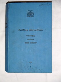
Book, Ports and Harbours Division, Sailing Directions Victoria including Bass Strait, 1970
... non-fiction sailing Victoria Bass Strait communications fuel maps charts weather navigation Inside front cover, white sticker with red printing "JOHN DONNE & SON / CHARTS, MAPS & MARINE BOOKS / 372 LITTLE BOURKE ST. / MELBOURNE" Blue hard cover book of 745 pages Sailing Directions Victoria including Bass Strait Book Ports and Harbours Division ...Blue hard cover book of 745 pagesInside front cover, white sticker with red printing "JOHN DONNE & SON / CHARTS, MAPS & MARINE BOOKS / 372 LITTLE BOURKE ST. / MELBOURNE" non-fiction, sailing, victoria, bass strait, communications, fuel, maps, charts, weather, navigation -
 Harcourt Valley Heritage & Tourist Centre
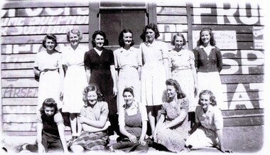
photograph, Fruit Packers, 1946
... charts that ensured a box of even sized fruit. Depicts women’s occupations in horticultural district. Photo depicting 12 women standing outside the Harcourt Fruit Growers Association packing shed on the loading dock. The registered office sign is on the wall behind Mrs I. Gibbons. There is other sign writing on the wall weather ...Apple packers were employed on piece work to pack fruit from the sizing graders into wooden boxes, following prescriptive packing charts that ensured a box of even sized fruit. Depicts women’s occupations in horticultural district. Photo depicting 12 women standing outside the Harcourt Fruit Growers Association packing shed on the loading dock. The registered office sign is on the wall behind Mrs I. Gibbons. There is other sign writing on the wall weather boards of the building. The weather boards to the left of the window appear to be second hand as the writing is partly covered up. It also appears to be warmer weather as all the women are in light clothing. -
University of Melbourne, Burnley Campus Archives
Document, Burnley Weather Records, 1951-1980
... rainfall charts observations burnley weather records Rainfall charts, observations, notes, correspondence Burnley Weather Records Document ...Rainfall charts, observations, notes, correspondencerainfall charts, observations, burnley, weather records -
University of Melbourne, Burnley Campus Archives
Book - Register, Rainfall Registration, 1951-1983
... Rainfall registration charts in a variety of forms recorded at Burnley. (1) 1 page handdrawn on cardboard, monthly and annual totals 1951-1978 (part). (2) 1974-1978 daily. (3) Unused forms. (4) 1980-1983. (5) Climatological Data for Melbourne up to 31st December 1964. Found in a folder labelled, "Burnley Weather...rainfall registration weather reports climatological data Rainfall registration charts in a variety of forms recorded at Burnley. (1) 1 page handdrawn on cardboard, monthly and annual totals 1951-1978 (part). (2) 1974-1978 daily. (3) Unused forms. (4) 1980-1983. (5) Climatological Data for Melbourne up to 31st December 1964. ...Rainfall registration charts in a variety of forms recorded at Burnley. (1) 1 page handdrawn on cardboard, monthly and annual totals 1951-1978 (part). (2) 1974-1978 daily. (3) Unused forms. (4) 1980-1983. (5) Climatological Data for Melbourne up to 31st December 1964. Found in a folder labelled, "Burnley Weather Records." rainfall registration, weather reports, climatological data
