Showing 80 items matching "closer settlement"
-
 Tatura Irrigation & Wartime Camps Museum
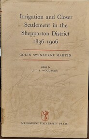
Book - Irrigation and Closer Settlement in the Shepparton District 1836 - 1906, Colin Swinburne Martin
... Irrigation and Closer Settlement in the Shepparton District 1836 - 1906...Irrigation and Closer Settlement in the Shepparton District 1836 - 1906...irrigation and closer settlement around Shepparton district...There are brown marks inside the cover that indicate it was taped down at some stage in it's life Irrigation and Closer Settlement in the Shepparton District 1836 - 1906 Book Irrigation and Closer Settlement in the Shepparton District 1836 - 1906 Colin Swinburne Martin ...Green hardvocer with very dark cream wrap around cover, with black and read writing , front fly leaf has description of contents. Stamped inside is Churchlands Teachers college library, Pearson St, Churchlands, Western Australia 6018. Same stamp is also on back page of book. There are brown marks inside the cover that indicate it was taped down at some stage in it's lifenon-fictionirrigation and closer settlement around shepparton district, mcallister, colin swinburne martin -
 Tatura Irrigation & Wartime Camps Museum
Book, Closer Settlement Days
... Closer Settlement Days...closer settlement days...Arrived in Australia 1924 closer settlement days geals stark forbes brown a brown n undera tatura closer settlement gv books history local White plastic front cover. ...Story of three Scottish imigrant families - Geals, Stark, Forbes. Arrived in Australia 1924White plastic front cover. Black spine and backcover. Black letters title CS Days in the Goulburn Valley by Agnes Mary Brown (Nessie)closer settlement days, geals, stark, forbes, brown a, brown n, undera, tatura, closer settlement gv, books, history, local -
Tatura Irrigation & Wartime Camps Museum
Book - Family History, Agnes Mary Brown (Nessie), Closer Settlement Days
... Closer Settlement Days...Title Closer Settlement Days in the Goulburn Valley by Agnes Mary Brown (Nessie)....Black letters. Closer Settlement Days Book - Family History Agnes Mary Brown (Nessie) ...Story of three Scottish immigrant families - Geals, Stark and Forbes. Arrived in Australian 1924.White plastic front cover, black spine and back cover. Black letters. Title Closer Settlement Days in the Goulburn Valley by Agnes Mary Brown (Nessie).geals family, stark family, forbes family, agnes mary brown (nessie), scottish migrants -
 Victorian Railway History Library
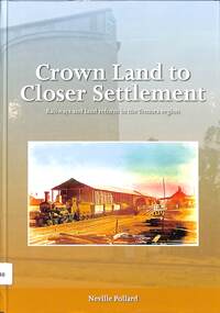
Book, Pollard, Neville, Crown Land to Closer Settlement: Railway and land reform in the Temora region, 2018
... Crown Land to Closer Settlement: Railway and land reform in the Temora region...Crown Land to Closer Settlement: Railway and land reform in the Temora region Book Pollard, Neville Australian Railway Historical Society NSW Division ...This book charts the development of the rail network that opened the northern Riverina region of southern New South Wales to closer settlement and agriculture.index, ill, maps, p.264.non-fictionThis book charts the development of the rail network that opened the northern Riverina region of southern New South Wales to closer settlement and agriculture.railroad construction - new south wales - history, railroad trains -- new south wales -- temora region -- history -
 Bendigo Historical Society Inc.
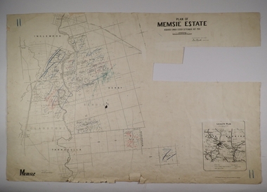
Map - MEMSIE ESTATE, 26/08/1905
... ... Closer Settlement Act 1904....Map:Plan of Memsie estate, aquired under Closer Settlement Act 1904. Parish plan. Map dated 26/08/1905....History House 11 Mackenzie Street Bendigo goldfields MAP estate Memsie Estate Closer Settlement Act 1904. Map:Plan of Memsie estate, aquired under Closer Settlement Act 1904. ...Map:Plan of Memsie estate, aquired under Closer Settlement Act 1904. Parish plan. Map dated 26/08/1905.map, estate, memsie estate, closer settlement act 1904. -
 Bendigo Historical Society Inc.
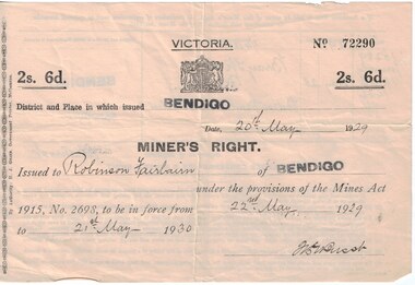
Document - Mining in Bendigo, 1909 to 1939
... victorian lands department and closer settlement commission...Documents related to Mining in Bendigo, purchase of a property. 8663.3a Front of Miners Right issued to Robinson Fairbairn 8663.3b Back of Miners Right issued to Robinson Fairbairn 8663.3c Valuation from Shire of Marong, 14 Bray St., California Gully 8663.3d Receipt from the Lands Department and Closer settlement Commission 8663.3e Receipt from the Lands Department and Closer settlement Commission 8663.3f Receipt from the Lands Department and Closer settlement Commission 8663.3g Receipt from the Lands Department 8663.3h Receipt from Albert E. ...History House 11 Mackenzie Street Bendigo goldfields BHS Collection history mining robinson fairbairn collection miners right victorian lands department and closer settlement commission albert e brown land and stock agent Documents related to Mining in Bendigo, purchase of a property. 8663.3a Front of Miners Right issued to Robinson Fairbairn 8663.3b Back of Miners Right issued to Robinson Fairbairn 8663.3c Valuation from Shire of Marong, 14 Bray St., California Gully 8663.3d Receipt from the Lands Department and Closer settlement Commission 8663.3e Receipt from the Lands Department and Closer settlement Commission 8663.3f Receipt from the Lands Department and Closer settlement Commission 8663.3g Receipt from the Lands Department 8663.3h Receipt from Albert E. ...BHS CollectionDocuments related to Mining in Bendigo, purchase of a property. 8663.3a Front of Miners Right issued to Robinson Fairbairn 8663.3b Back of Miners Right issued to Robinson Fairbairn 8663.3c Valuation from Shire of Marong, 14 Bray St., California Gully 8663.3d Receipt from the Lands Department and Closer settlement Commission 8663.3e Receipt from the Lands Department and Closer settlement Commission 8663.3f Receipt from the Lands Department and Closer settlement Commission 8663.3g Receipt from the Lands Department 8663.3h Receipt from Albert E. Brown Land and Stock Agenthistory, mining, robinson fairbairn collection, miners right, victorian lands department and closer settlement commission, albert e brown land and stock agent -
Bendigo Historical Society Inc.
Map - BAMAWM ESTATE, 12/.08/1912
... ... Closer settlement Acts 1904...Map: Bamawm Estate, Acquired under Closer settlements Acts 1904, County of Bendigo. Parish Plan Canvas backed...History House 11 Mackenzie Street Bendigo goldfields MAP Bendigo rural Bamawm Estate Closer settlement Acts 1904 County of Bendigo Map: Bamawm Estate, Acquired under Closer settlements Acts 1904, County of Bendigo. ...Map: Bamawm Estate, Acquired under Closer settlements Acts 1904, County of Bendigo. Parish Plan Canvas backed. ( number 130 in Map Cupboard 1)map, bendigo, rural, bamawm estate, closer settlement acts 1904, county of bendigo -
Bendigo Historical Society Inc.
Map - BAMAWM ESTATE, 24/02/1931
... ... closer settlement Acts 1904...Map: Bamawm Estate, Aquired under closer settlement Act 1904, County of Bendigo. Parish plan Canvas backed ( number 129 in Map Cupboard 1)...History House 11 Mackenzie Street Bendigo goldfields MAP Bendigo rural Bamawm estate closer settlement Acts 1904 County of Bendigo Map: Bamawm Estate, Aquired under closer settlement Act 1904, County of Bendigo. ...Map: Bamawm Estate, Aquired under closer settlement Act 1904, County of Bendigo. Parish plan Canvas backed ( number 129 in Map Cupboard 1)map, bendigo, rural, bamawm estate, closer settlement acts 1904, county of bendigo -
Whitehorse Historical Society Inc.
Letter - Correspondence, Obtaining a grant of Crown Land at rear of Myrtle Grove, 1932
... ...Victoria. Closer Settlement Board...Correspondence between Council and Closer Settlement Board re land in Pakenham Street including plans of allotments. ...Pakenham Street Blackburn Myrtle Grove Blackburn Shire of Blackburn and Mitcham Sheehan Malcolm Hearn Dal Victoria. Closer Settlement Board Correspondence between Council and Closer Settlement Board re land in Pakenham Street including plans of allotments. ...Correspondence between Council and Closer Settlement Board re land in Pakenham Street including plans of allotments.Correspondence between Council and Closer Settlement Board re land in Pakenham Street including plans of allotments. Also further correspondence re land being sold by Malcolm Sheehan to Dal Hear.Correspondence between Council and Closer Settlement Board re land in Pakenham Street including plans of allotments.pakenham street, blackburn, myrtle grove, blackburn, shire of blackburn and mitcham, sheehan, malcolm, hearn, dal, victoria. closer settlement board -
 Ballarat Diocesan Historical Commission
Poster, Government Land Sales Poster
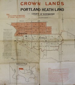
... Closer Settlement, Soldiers Settlement, Government Poster. ...Government poster advertising land sales to promote closer settlement in Portland area. The acquisition of land for the purpose of closer settlement was first authorised under the provisions of the Land Act 1898. ...Ballarat Diocesan Historical Commission 5 Lyons St South Ballarat goldfields Government poster advertising land sales to promote closer settlement in Portland area. The acquisition of land for the purpose of closer settlement was first authorised under the provisions of the Land Act 1898. ...Government poster advertising land sales to promote closer settlement in Portland area. The acquisition of land for the purpose of closer settlement was first authorised under the provisions of the Land Act 1898. In 1917 under the provisions of the Discharged Soldiers' Settlement Act, the scheme reverted to the Soldiers' Settlement scheme when the government undertook the settlement of discharged soldiers on lands set aside exclusively for them as a reward for their war service.closer settlement, soldiers settlement, government poster. land sales, portland. -
 Myrtleford and District Historical Society
Tobacco bale stencil
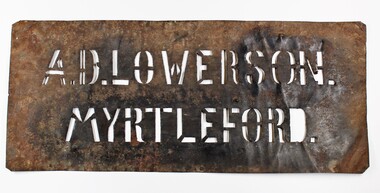
... ...closer settlement board...Lowerson acquired one of 19 blocks assigned by the Closer Settlement Board on the 700 acre estate in 1920. ...Lowerson acquired one of 19 blocks assigned by the Closer Settlement Board on the 700 acre estate in 1920. ...Stencil used by Sgt. Albert David Lowerson, VC, a soldier settler on Merriang Estate near Myrtleford. Lowerson acquired one of 19 blocks assigned by the Closer Settlement Board on the 700 acre estate in 1920. The stencil marked bales of cured tobacco leaves prior to shipment to Melbourne. Lowerson was one of the few successful soldier settler farmers in the district, operating a piggery, dairy farming and growing tobacco for almost 20 years on "St. Quentin". (Lowerson was awarded the Victoria Cross at Mont St. Quentin on September 1, 1918.) His success and status enabled him to lead a submission on farm debt and infrastructure problems when the soldier settlement scheme was being reviewed at government level. He was active locally on these issues and supported fund raising for a war memorial, memorial hall and veteran welfare.The stencil represents the achievements of A.D.Lowerson, VC as an isolated example of success as a WW1 soldier settler and as a local identity who stridently supported the need for recognition and support of ex-service personnel.Stencil made of thin sheet metal, rusted .Wording of stencil "A.D.LOWERSON. MYRTLEFORD." lowerson a.d., merriang estate, myrtleford, closer settlement board, tobacco, st. quentin, victoria cross, world war 1 -
Federation University Historical Collection
Book, Frank Hurley, An Event That Never Happened: The history and politics of decentralisation in Victorian and New South Wales 1885-1985 (Thesis), 1989
... ...Closer settlement acts...Frank hurley thesis doctorate decentralisation ppoulation economics policy Closer settlement acts urbanisation decentralisation league war and reconstruction central planning town planning victorian Decentralisatoin League Owen paper mill Slough Estate Noel Mobbs Ballarat Common Edgar Bartrop Australian Paper Mills Bendix Mintex ball ballarat development committee Red hard covered thesis undertaken for a Doctory of Philosphy ot the University of Melbourne. ...This thesis is an account of movements and policies for decentralisation of population and economic activity away from metropolitan to non-metropolitan areas in Victoria and New South Wales between 1885 and 1985. Red hard covered thesis undertaken for a Doctory of Philosphy ot the University of Melbourne. frank hurley, thesis, doctorate, decentralisation, ppoulation, economics, policy, closer settlement acts, urbanisation, decentralisation league, war and reconstruction, central planning, town planning, victorian decentralisatoin league, owen paper mill, slough estate, noel mobbs, ballarat common, edgar bartrop, australian paper mills, bendix mintex, ball, ballarat development committee -
Marysville & District Historical Society
Article (item) - Magazine Article, Coranderrk-A Station Never a Mission, Unknown
... ...closer settlement act...A magazine article on the history of Coranderrk based on a historical component of a survey of Coranderrk Station. coranderrk coranderrk station dr marie hansen fels healesville and district aboriginal community john green healesville acheron river mohican native police corps merri creek closer settlement act badger creek hops cattle royal commission of 1877 board of enquiry 1881 lake tyers A magazine article on the history of Coranderrk based on a historical component of a survey of Coranderrk Station. ...A magazine article on the history of Coranderrk based on a historical component of a survey of Coranderrk Station.A magazine article on the history of Coranderrk based on a historical component of a survey of Coranderrk Station.coranderrk, coranderrk station, dr marie hansen fels, healesville and district aboriginal community, john green, healesville, acheron river, mohican, native police corps, merri creek, closer settlement act, badger creek, hops, cattle, royal commission of 1877, board of enquiry 1881, lake tyers -
Ballarat Heritage Services
Document, Helen Doyle & Context Pty Ltd, Moyne Heritage Study Stage 2 Vol 2, 2006
... ...closer settlement...Ballarat Heritage Services PO Box 2209 Bakery Hill Post Office goldfields Moyne Minhamite Port Fairy Mt Shadwell Mt Rouse Mt Napier Mt Eccles Tower Hill Dhauwurdwurrung Djabwurrung Giraiwurrung Caramut James Atkinson Special Survey William Rutledge Yangery Land selection act closer settlement soldier settlement Framlingham lime burning Atkinson’s Belfast Survey Belfast Killarney Crossley Aboriginal Protectorate Lake COndah Hexham Hexham Common School Koroit convent hurling mile posts Kirkstall Ballyhurst Dundonnell Curdievale Ballangeich Hawkesdale Irish Scottish Aborigines Tower Hill Cemetery St Brigid’s Catholic Church 141 page heritage study Moyne Heritage Study Stage 2 Vol 2 Document Helen Doyle & Context Pty Ltd ...141 page heritage studymoyne, minhamite, port fairy, mt shadwell, mt rouse, mt napier, mt eccles, tower hill, dhauwurdwurrung, djabwurrung, giraiwurrung, caramut, james atkinson, special survey, william rutledge, yangery, land selection act, closer settlement, soldier settlement, framlingham, lime burning, atkinson’s belfast survey, belfast, killarney, crossley, aboriginal protectorate, lake condah, hexham, hexham common school, koroit convent, hurling, mile posts, kirkstall, ballyhurst, dundonnell, curdievale, ballangeich, hawkesdale, irish, scottish, aborigines, tower hill cemetery, st brigid’s catholic church -
Tatura Irrigation & Wartime Camps Museum
Book - Book - Local History, Wyuna - 1840 - 1940
... ...Closer Settlement...Wyuna Northern Plain Closer Settlement A Story of Settlement on the Northern Plains from 1840 to 1940 Wyuna - 1840 - 1940 Book Book - Local History ...A Story of Settlement on the Northern Plains from 1840 to 1940non-fictionA Story of Settlement on the Northern Plains from 1840 to 1940wyuna, northern plain, closer settlement -
![Parish of Nunawading, County of Bourke showing land acquired under Closer Settlement Acts [C 1887]](/media/collectors/56f368632162f118acbff12e/items/60d923316e5f99545134f182/item-media/6147b12a4806c7ae686c24e4/item-fit-380x285.jpg?cb=6) Whitehorse Historical Society Inc.
Whitehorse Historical Society Inc.Map, Parish of Nunawading, ca 1887
... Parish of Nunawading, County of Bourke showing land acquired under Closer Settlement Acts [C 1887] 1947 reprint....Whitehorse Historical Society Inc. 2-10 Deep Creek Road Mitcham melbourne parish of nunawading box hill maps land settlement Parish of Nunawading, County of Bourke showing land acquired under Closer Settlement Acts [C 1887] Parish of Nunawading, County of Bourke showing land acquired under Closer Settlement Acts [C 1887] 1947 reprint. ...Parish of Nunawading, County of Bourke showing land acquired under Closer Settlement Acts [C 1887]Parish of Nunawading, County of Bourke showing land acquired under Closer Settlement Acts [C 1887] 1947 reprint.Parish of Nunawading, County of Bourke showing land acquired under Closer Settlement Acts [C 1887] parish of nunawading, box hill, maps, land settlement -
 Bendigo Historical Society Inc.
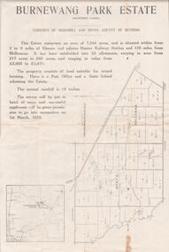
Document - EDWIN BUCKLAND COLLECTION: BURNEWANG PARK ESTATE, 1982
... Applications re closer Settlement board from Discharged Soldiers holding Qualification certificates to take up land for Farm Allotments....Applications re closer Settlement board from Discharged Soldiers holding Qualification certificates to take up land for Farm Allotments. ...Document. Burnewang Park Estate. Applications re closer Settlement board from Discharged Soldiers holding Qualification certificates to take up land for Farm Allotments. -
Tatura Irrigation & Wartime Camps Museum
Book, Girgarre Living History, Girgarre. Girgarre Living History, 2016
... Girgarre - an extraordinary history, closer settlement, soldier settlement and family stories....Tatura Irrigation & Wartime Camps Museum 49 Hogan Street Tatura the-murray Girgarre - an extraordinary history, closer settlement, soldier settlement and family stories. ...Girgarre - an extraordinary history, closer settlement, soldier settlement and family stories.Tells of the history of Girgarre, with information obtained from a collection of stories and extensive research into the Closer and Soldier Settlement of the districtRectangular shaped book ,aerial photo of the township and environs of Girgarre,on Market Day, September 2013. Photo extends over front & back covers, highly colourful cover. 251 pages ,B/W photos and maps of local families and local scenes.girgarre, family histories -
Tatura Irrigation & Wartime Camps Museum
Book, Girgarre Living History, Girgarre. Girgarre Living History, 2016
... Girgarre - an extraordinary history, closer settlement, soldier settlement and family stories....Tatura Irrigation & Wartime Camps Museum 49 Hogan Street Tatura the-murray Girgarre - an extraordinary history, closer settlement, soldier settlement and family stories. ...Girgarre - an extraordinary history, closer settlement, soldier settlement and family stories.Tells of the history of Girgarre, with information obtained from a collection of stories and extensive research into the Closer and Soldier Settlement of the districtRectangular shaped book ,aerial photo of the township and environs of Girgarre, on Market Day, September 2013. Photo extends over front & back covers, highly colourful cover. 251 pages. B/W photos and maps of local families and local scenes.girgarre, family histories, soldier settlement -
 Whitehorse Historical Society Inc.
Document, A Short history of Nunawading, 1971
... Walker & Tess Nun. up to 1860, Land settlement & agriculture, Closer settlement, Industry, Homes, Religion, Education, Recreation & clubs, Local government 1925 - 1970...Walker & Tess Nun. up to 1860, Land settlement & agriculture, Closer settlement, Industry, Homes, Religion, Education, Recreation & clubs, Local government 1925 - 1970 Compiled by Eleanor Ronaldson (Mrs McCoy) , Nunawading Historical Society, 1971. ...Compiled by Eleanor Ronaldson (Mrs McCoy) , Nunawading Historical Society, 1971.Compiled by Eleanor Ronaldson (Mrs McCoy) , Nunawading Historical Society, 1971.Compiled by Eleanor Ronaldson (Mrs McCoy) , Nunawading Historical Society, 1971.local history, city of nunawading, ronaldson eleanor, mccoy eleanor -
Tatura Irrigation & Wartime Camps Museum
Fence Droppers, late 19th century to early 20th
... Split timber fence droppers were used with the earliest wire fences especially with closer settlement areas like Tatura. The donors family were Tatura hardware and timber merchants so may have made and supplied these to farmers. ...Tatura Irrigation & Wartime Camps Museum 49 Hogan Street Tatura the-murray Split timber fence droppers were used with the earliest wire fences especially with closer settlement areas like Tatura. The donors family were Tatura hardware and timber merchants so may have made and supplied these to farmers. fence dropper wood fence dropper fencing material 3 wooden dropper split with axe to shape rather than sawn. 6 holes for wire to pass through (6 gauge). ...Split timber fence droppers were used with the earliest wire fences especially with closer settlement areas like Tatura. The donors family were Tatura hardware and timber merchants so may have made and supplied these to farmers. 3 wooden dropper split with axe to shape rather than sawn. 6 holes for wire to pass through (6 gauge). Used between posts to support wires. Made from straight grained timber, grey box.fence dropper, wood fence dropper, fencing material -
Federation University Historical Collection
Booklet, The Stock Exchange of Melbourne: Monthly Official List of Quotations and Prices Current, 1909, 1909
... Contents include brokerage, Closer Settlement Loans. Banks. Building Societies, Banking and Financial Institutions, Gas, Insurance, Breweries, Trustee, mines, Goldmines in Ballarat, Daylesford, Stawell and District, Dredging Companies, Coal mines, Municipal Loans, Metal Rates since 1888, Calls Due 13 January 1909, List of Legal Managers and Secretariat of Mining Companies, Member of the Melbourne Stock Exchange....Contents include brokerage, Closer Settlement Loans. Banks. Building Societies, Banking and Financial Institutions, Gas, Insurance, Breweries, Trustee, mines, Goldmines in Ballarat, Daylesford, Stawell and District, Dredging Companies, Coal mines, Municipal Loans, Metal Rates since 1888, Calls Due 13 January 1909, List of Legal Managers and Secretariat of Mining Companies, Member of the Melbourne Stock Exchange. ...Small, brown, soft covered booklet. Contents include brokerage, Closer Settlement Loans. Banks. Building Societies, Banking and Financial Institutions, Gas, Insurance, Breweries, Trustee, mines, Goldmines in Ballarat, Daylesford, Stawell and District, Dredging Companies, Coal mines, Municipal Loans, Metal Rates since 1888, Calls Due 13 January 1909, List of Legal Managers and Secretariat of Mining Companies, Member of the Melbourne Stock Exchange.non-fictionmelbourne stock exchange, stockbrokers, f.w. holst, w.s. ham, walter s. ham, f.w. were, r.e. tweddell, w.d. thompson, w.m. williams, n.m. dudgeon, w.m. acheson, e.g. ross, j.h. dill, s. stretch, j.c. bell -
 Sunshine and District Historical Society Incorporated
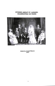
Document - Stories About St. Albans Celebrating 125 Years, Joseph "Joe" Ribarow, 2018 Revised and reprinted
... Albans occurred in the early 1900s when the Closer Settlement board subdivided Overnewton Estate into blocks of 200 to 300 acres and offered these for selection. ...Albans occurred in the early 1900s when the Closer Settlement board subdivided Overnewton Estate into blocks of 200 to 300 acres and offered these for selection. ...The most significant phase in the settlement of St. Albans occurred in the early 1900s when the Closer Settlement board subdivided Overnewton Estate into blocks of 200 to 300 acres and offered these for selection. This attracted the new pioneers' families to the district, such as the McAuleys, Boyds, Andersons, Stevens, Colemans, Griffiths, McRaes, King and others to acquire land along Taylors Road and in the Western part of St. Albans through to Sydenham.The stories in this document are about the families who are directly connected to the above era or came somewhat later, but all have contributed to the development of community. They are stories about transition of St. Albans from a sparse rural district to a number of crowded suburban neighborhoods.Stories About St. Albans Celebrating 125 Years Marion McAuley John Stevens Self and Goddard Jimmy Knowles Isabelle Davidson John Perrett Fred Barlowst. albans, john stevens, self and goddard, jimmy knowles, isabelle davidson, john perrett, fred barlow, marion mcauley -
 Warrnambool and District Historical Society Inc.
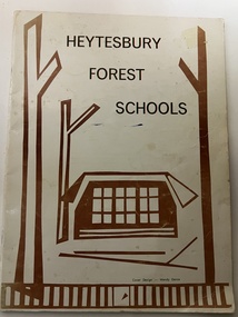
Booklet, Collett and Bain, Heytesbury Forest School, c.1971
... The Heytesbury Forest was largely deforested by the Bailey Closer Settlement Scheme of the 1930s and later the establishment of more farming properties in the 1950s. ...The Heytesbury Forest was largely deforested by the Bailey Closer Settlement Scheme of the 1930s and later the establishment of more farming properties in the 1950s. ...This booklet, by Rosamund Duruz, gives the history of the schools in the Heytesbury Forest area. The Heytesbury Shire Council was established in 1863 and the first schools in the area opened in the 1870s. Most of them were closed when Timboon Consolidated School (later Timboon High School) opened in 1948. The Heytesbury Forest was largely deforested by the Bailey Closer Settlement Scheme of the 1930s and later the establishment of more farming properties in the 1950s. This booklet is of interest as a comprehensive history of the schools in the Heytesbury Forest area pre 1970. It will be useful for researchers. This is a soft-cover booklet of 63 pages. The cover is a cream colour with brown images of trees and a school on the front cover. The booklet includes a map, a sketch and several black and white photographs. The booklet is bound with metal staples.schools in heytesbury forest, victoria, rosamund duruz, historian, history of warrnambool -
 Bendigo Historical Society Inc.
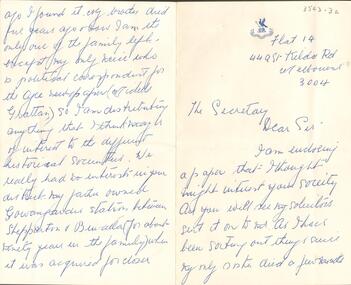
Document - LETTER FROM GRATTAN
... The writer's father had owned a Station between Shepparton and Benalla which was acquired for closer settlement. Letter has a dark blue monogram at the top with a bird standing on a block and in one leg holding a lance. ...The writer's father had owned a Station between Shepparton and Benalla which was acquired for closer settlement. Letter has a dark blue monogram at the top with a bird standing on a block and in one leg holding a lance. ...Hand written letter to The Secretary from ? Grattan, Flat 14, 449 St Kilda Rd, Melbourne 3004, enclosing a paper which might interest the Society. It had been sent to the person by their solicitors. As the writer was disposing of papers, the papers were sent to the Society as they had no interests in the district. The writer's father had owned a Station between Shepparton and Benalla which was acquired for closer settlement. Letter has a dark blue monogram at the top with a bird standing on a block and in one leg holding a lance. The wings are raised. Underneath is: Pro patria vivere et mori. Albert Richardson Collectiondocument, letter from grattan -
 Department of Energy, Environment and Climate Action
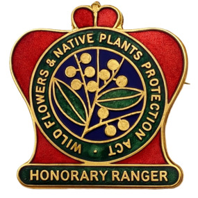
Badge - Honorary Ranger badge
... The Wild Flowers and Native Plants Protection Act 1930 sought to prevent the picking of protected wild flowers and native plants during the protected period on any Crown Land or State forest, land reserved under the Land Act 1928 or the Closer Settlement Act 1928, and on any private land the owner or lessee of which had not given permission for any picking. ...Department of Energy, Environment and Climate Action 71-79 Kyle Road Altona North The Wild Flowers and Native Plants Protection Act 1930 sought to prevent the picking of protected wild flowers and native plants during the protected period on any Crown Land or State forest, land reserved under the Land Act 1928 or the Closer Settlement Act 1928, and on any private land the owner or lessee of which had not given permission for any picking. ...The Wild Flowers and Native Plants Protection Act 1930 sought to prevent the picking of protected wild flowers and native plants during the protected period on any Crown Land or State forest, land reserved under the Land Act 1928 or the Closer Settlement Act 1928, and on any private land the owner or lessee of which had not given permission for any picking. The Act was administered by the Forests Commission and, on the recommendation of the Commission, the Minister could appoint ‘honorary rangers’ to assist.brass lapel badges with safety-pin attachment on reverse side. Red, green and blue enamel background to lettering on obverse sideObverse: WILD FLOWER & NATIVE PLANTS PROTECTION ACT; HONORARY RANGER Reverse (badge 1): P.J. KING MELB 228 Reverse (badge 2): P.J. KING MELB 229 -
 Phillip Island and District Historical Society Inc.
Photograph Album, Kodak, Phillip Island Cemetery, c 1990
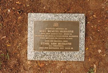
... 4 photographs relating to the McHaffie family. 466-15 & 466-16: Noel Wemyss & Vernon Suter Wemyss McHaffie were grandchildren of the first permanent European Settlers of Phillip Island (John David & Georgianna McHarrie who leased the whole Island as a sheep and cattle run for 45 years until Closer Settlement in 1868 reduced their holding to 640 acres and who are buried at the St. ...There are 6.2 acres of wetlands near the cemetery entrance. phillip island cemetery nancy mchaffie edith jeffrey 4 photographs relating to the McHaffie family. 466-15 & 466-16: Noel Wemyss & Vernon Suter Wemyss McHaffie were grandchildren of the first permanent European Settlers of Phillip Island (John David & Georgianna McHarrie who leased the whole Island as a sheep and cattle run for 45 years until Closer Settlement in 1868 reduced their holding to 640 acres and who are buried at the St. ...The Album was compiled by Nancy McHaffie late 1990's, with the assistance of Edith Jeffery's, with her book "Garden of Memories" and extensive knowledge of Phillip Island. The Cemetery lies back from the road and is surrounded by Manna Gums, rare Peppermint Gums, Blackwoods and other native trees. In all 25 acres of land were set aside as Crown Land in the land settlement of 1868. There are 6.2 acres of wetlands near the cemetery entrance.4 photographs relating to the McHaffie family. 466-15 & 466-16: Noel Wemyss & Vernon Suter Wemyss McHaffie were grandchildren of the first permanent European Settlers of Phillip Island (John David & Georgianna McHarrie who leased the whole Island as a sheep and cattle run for 45 years until Closer Settlement in 1868 reduced their holding to 640 acres and who are buried at the St. Kilda Cemetery, Melbourne). Noel's ashes are interred at the Phillip Island Cemetery and Vernon's were scattered at Ventnor Philip Island at the site of the original homestead. 466-17 & 466-18: As per the Plaque: "Mulberry Tree: Muberry cutting from original tree planted by John D McHaffie First Settlers Phillip Island 1842. Plaque by courtesy Cherry McFee 1987.phillip island cemetery, nancy mchaffie, edith jeffrey -
Warrnambool and District Historical Society Inc.
Document, Wollaston sale, 1919
... In 1919 the Closer Settlement Board of Victoria acquired Wollaston and 17 lots were sold to returned soldiers for farming purposes. ...In 1919 the Closer Settlement Board of Victoria acquired Wollaston and 17 lots were sold to returned soldiers for farming purposes. ...This is a poster advertising the sale of part of the Wollaston Estate in Warrnambool in 1919. The sections for sale were Allotments 1, 18 and 19 which included the Wollaston Homestead. The original Wollaston property of 679 acres was selected by Thomas Manifold in the late 1840s. This land, on the northern side of the Merri River, near the Woodford Road was three kilometres from the Warrnambool town. The first farmer we know who leased the property was William Simpson. Walter Manifold inherited the property and he took it over in 1884. The swing bridge he built in 1890 still stands today. In 1919 the Closer Settlement Board of Victoria acquired Wollaston and 17 lots were sold to returned soldiers for farming purposes. By 1930 there were only five soldier settlers remaining. In 2009 further subdivision took place with lots sold for residential purposes. The homestead allotments were sold separately in 1919 with various owners of the homestead itself recorded since that time. This poster is of interest as it shows the areas of the Wollaston Estate which were sold in 1919. The history of this estate is well-documented and of importance in the history of Warrnambool. This is a sheet of paper with red and black printing and a map of the Wollaston Estate which is photo-lithographed. The sheet has been folded three times. It has some small tears at the top of the page. wollaston, history of warrnambool, walter manifold -
Warrnambool and District Historical Society Inc.
Correspondence (Rose Park), 1940s
... The Soldier Settlement Commission wanted to acquire 1500 acres of Rose Park but Stan Baulch argued successfully that the management of his farm could not withstand the loss of so much land and eventually 300 acres of Rose Park land was sold for closer settlement. Stan Baulch was a prominent member of the Warrnambool and District Historical Society for many years and contributed many articles and booklets on local historical matters. ...The Soldier Settlement Commission wanted to acquire 1500 acres of Rose Park but Stan Baulch argued successfully that the management of his farm could not withstand the loss of so much land and eventually 300 acres of Rose Park land was sold for closer settlement. Stan Baulch was a prominent member of the Warrnambool and District Historical Society for many years and contributed many articles and booklets on local historical matters. ...These are four letters and a document regarding the proposal in the 1940s by the Victorian Department of Lands and Survey to acquire sections of the property, Rose Park, to establish several Soldier Settlement farms. Rose Park, near Willatook, was owned by Stan Baulch (1897-1980), the son of Samuel and Eliza Baulch. Samuel Baulch had acquired the property of Dunmore, between Macarthur and Hawkesdale, in 1893 and Stan had inherited portion of this property after his father’s death. He named his portion Rose Park. The Soldier Settlement Commission wanted to acquire 1500 acres of Rose Park but Stan Baulch argued successfully that the management of his farm could not withstand the loss of so much land and eventually 300 acres of Rose Park land was sold for closer settlement. Stan Baulch was a prominent member of the Warrnambool and District Historical Society for many years and contributed many articles and booklets on local historical matters. This correspondence is of interest as an example of the establishment of Soldier Settlement farms in Victoria post World War Two and the difficulties faced by some property owners opposed to the acquisition of their land. These items will be useful for research. .1 A six-page letter written in pencil .2 A two page letter in black typing ( contents as in .1 above) .3 A one page letter, typed, with a handwritten signature .4 A sheet of paper containing a statement re purchase of land with some inserted handwritten material .5 A two page letter with handwritten material baulch family, western district, victoria, history of warrnambool -
 Warrnambool and District Historical Society Inc.
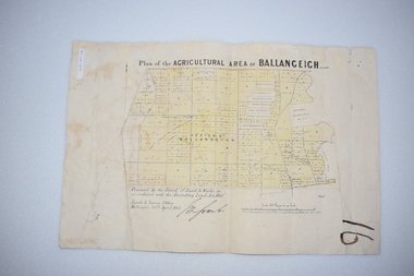
Original Document, Map: Agricultural area of Ballangeich 1865, 1865
... The previously larger runs which were mainly cattle and sheep based were now more open to closer settlement and a greater variety in farming.The lots range in size from approximately 50 acres to around 600 acres.Some areas are set aside for reserves. ...The previously larger runs which were mainly cattle and sheep based were now more open to closer settlement and a greater variety in farming.The lots range in size from approximately 50 acres to around 600 acres.Some areas are set aside for reserves. ...George Eddington arrived in Australia in 1839 and named and established property in 1841 calling the property Ballangeich after a Pass near his home town of Stirling in Scotland. It is situated 151 miles west of Melbourne and to the south of Mortlake and was originally part of the Mortlake shire, which was proclaimed 26th Jan 1864. Nearest streams are the Hopkins Riverand Lyall and Drysdale creek running through good agricultural land. This map relates to the breaking up of large runs which the Victorian government enabled through selection acts of the 1860's. The previously larger runs which were mainly cattle and sheep based were now more open to closer settlement and a greater variety in farming.The lots range in size from approximately 50 acres to around 600 acres.Some areas are set aside for reserves. By 1886 the population of Ballangeich had grown to around 600 with an hotel, three state schools and a church.Tri weekly coaches ran to Colac, Warrnambool and Camperdown providing access to supplies mail and communication. This map is typical of many which were produced in the 1860's in Victoria during a significant period of Victoria's and Warrnambool district history.Rectangular light card paper with black text showing allotments of land The area is coloured in green with scale at bottom right cornerAt the top: Plan of the Agricultural area of Ballangeich 1865 At the bottom left: Prepared by the Board of Lands & Works in accordance with the Amending Land Act 1865 Lands & Survey Office Melbourne 13th April 1865. With signaturehistory of warrnambool, ballangeich, land surveys victoria 1865, lands act 1865 victoria, ballangeich map 1865