Showing 253 items matching "community bus"
-
 Port Melbourne Historical & Preservation Society
Photograph - Group with Port Melbourne Community Bus on Calder Highway, Pat Grainger, Aug 1993
... Group with Port Melbourne Community Bus on Calder Highway...This group took the free community bus to Bendigo to see daffodils at Kyneton and woollen mills at Bendigo. ...Photograph black and white panoramic of group with Port Melbourne Community Bus on Calder Hwy August 1993...liana thompson mayors wendy morris - city librarian beatrice (betty) goddard julie allen Photograph black and white panoramic of group with Port Melbourne Community Bus on Calder Hwy August 1993 Photograph Group with Port Melbourne Community Bus on Calder Highway Pat Grainger ...This group took the free community bus to Bendigo to see daffodils at Kyneton and woollen mills at Bendigo. Photographed at apple market along the highway by Pat Grainger. PMHPS members: Liana Thompson (3 from left; Wendy Morris (4 from left); Julie Allen (far right)Photograph black and white panoramic of group with Port Melbourne Community Bus on Calder Hwy August 1993transport - bus, kath morris, val salter (?), liana thompson, mayors, wendy morris - city librarian, beatrice (betty) goddard, julie allen -
Marysville & District Historical Society
THE TRIANGLE NEWS-VOL 39 NO 29-AUGUST 3 2012
... ...yea community bus...Marysville & District Historical Society 39 Darwin Street Marysville yarra-valley-and-the-dandenong-ranges marysville victoria australia bendigo bank a driving force in business recovery tom hafey at villains last game what's on when in august the committee of management of the gallipoli park precinct marysville community market creative triangle rating options council wants feedback murrindindi shire council men's breakfast church notices triangle community dinner narbethong progress association yea community bus position vacant adventurous cooks marysville pharmacy marysville medical clinic mayor's chair advertisements salesyard project covering many bases mystic mountain tourism marysville cultural community magician/illusionist real estate marysville golf report notice of proposal to make a local law THE TRIANGLE NEWS-VOL 39 NO 29-AUGUST 3 2012 ...marysville, victoria, australia, bendigo bank a driving force in business recovery, tom hafey at villains last game, what's on when in august, the committee of management of the gallipoli park precinct, marysville community market, creative triangle, rating options council wants feedback, murrindindi shire council, men's breakfast, church notices, triangle community dinner, narbethong progress association, yea community bus, position vacant, adventurous cooks, marysville pharmacy, marysville medical clinic, mayor's chair, advertisements, salesyard project covering many bases, mystic mountain tourism, marysville cultural community, magician/illusionist, real estate, marysville golf report, notice of proposal to make a local law -
Marysville & District Historical Society
THE TRIANGLE NEWS-VOL 32 NO 25-JULY 8 2005
... ...community bus...Marysville & District Historical Society 39 Darwin Street Marysville yarra-valley-and-the-dandenong-ranges marysville victoria australia dedicated volunteers religious education dates to remember deadline advertising rates general meeting liberal party community bus ceo visiting schedule disclaimer marysville cricket marysville police news advertisements THE TRIANGLE NEWS-VOL 32 NO 25-JULY 8 2005 ...marysville, victoria, australia, dedicated volunteers, religious education, dates to remember, deadline, advertising rates, general meeting liberal party, community bus, ceo visiting schedule, disclaimer, marysville cricket, marysville police news, advertisements -
Marysville & District Historical Society
THE TRIANGLE NEWS-VOL 40 NO 49-DECEMBER 20 2013
... ...yea community bus...marysville victoria australia marysville & district lions club friends of lions thanks triangle helpers what's on when in december the committee of management of the gallipoli park precinct australia day celebrations marysville community market creative triangle el kanah nye council recognises valuable work of ses church notices local carol services mayor's chair councillor comment yea arts carnivale 2014 advertisements real estate council adopts code red policy murrindindi shire council nye at crossways tender drainage upgrade-yea township half day closure council offices marysville golf report triangle christmas lights competition marysville region really long lunch mindfulness in marysville yea community bus kinglake library welcomes special storytime visitors black spur inn pizza and beer night cafe culture series 2014 council services over christmas/ny period 2013-2014 st john's parish hall dance alexandra resource recovery centres timetable THE TRIANGLE NEWS-VOL 40 NO 49-DECEMBER 20 2013 ...marysville, victoria, australia, marysville & district lions club, friends of lions, thanks triangle helpers, what's on when in december, the committee of management of the gallipoli park precinct, australia day celebrations, marysville community market, creative triangle, el kanah nye, council recognises valuable work of ses, church notices, local carol services, mayor's chair, councillor comment, yea arts carnivale 2014, advertisements, real estate, council adopts code red policy, murrindindi shire council, nye at crossways, tender drainage upgrade-yea township, half day closure council offices, marysville golf report, triangle christmas lights competition, marysville region really long lunch, mindfulness in marysville, yea community bus, kinglake library welcomes special storytime visitors, black spur inn pizza and beer night, cafe culture series 2014, council services over christmas/ny period 2013-2014, st john's parish hall dance alexandra, resource recovery centres timetable -
Marysville & District Historical Society
THE TRIANGLE NEWS-VOL 41 NO 24-JUNE 27 2014
... trial arrangements for community bus service...marysville victoria australia only vice presidents changed at lions club what's on when in june/july 2014 seasonal influenza vaccine available the committee of management of the gallipoli park precinct marysville community market creative triangle buxton history group questionnaire triangle community dinner el kanah village church notices marysville golf report mayor's chair by cr margaret rae councillor comment by cr john walsh koriella ward advertisements public comment draft rural roadside management plan residential & rural real estate marysville triangle real estate gallipoli park marysville new committee members needed working together on rural roadside marysville midweek netball trial arrangements for community bus service el kanah eat in eat out menu marysville preschool centre long day care & kindergarten statistical data for murrindindi shire now a click away murrindindi shire council marysville & district lions club presents the magic flute opera marysville primary school parent's club movie night opening of new marysville community golf & bowls clubrooms bendigo bank relocation pool life guard positions on the couch marysville at the community centre marysville library service welcome dr asghar bhatti to marysville buxton hotel roast night lake mountain ski patrol draft waste and resource recovery strategy THE TRIANGLE NEWS-VOL 41 NO 24-JUNE 27 2014 ...marysville, victoria, australia, only vice presidents changed at lions club, what's on when in june/july, 2014 seasonal influenza vaccine available, the committee of management of the gallipoli park precinct, marysville community market, creative triangle, buxton history group questionnaire, triangle community dinner, el kanah village, church notices, marysville golf report, mayor's chair by cr margaret rae, councillor comment by cr john walsh koriella ward, advertisements, public comment draft rural roadside management plan, residential & rural real estate, marysville triangle real estate, gallipoli park marysville, new committee members needed, working together on rural roadside, marysville midweek netball, trial arrangements for community bus service, el kanah eat in eat out menu, marysville preschool centre, long day care & kindergarten, statistical data for murrindindi shire now a click away, murrindindi shire council, marysville & district lions club presents the magic flute opera, marysville primary school, parent's club movie night, opening of new marysville community golf & bowls clubrooms, bendigo bank relocation, pool life guard positions, on the couch marysville at the community centre, marysville library service, welcome dr asghar bhatti to marysville, buxton hotel roast night, lake mountain ski patrol, draft waste and resource recovery strategy -
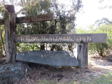
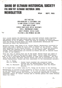 Eltham District Historical Society Inc
Newsletter, Newsletter, No. 44 September 1985
... Contents: • Next meeting, guest speaker, Cecile Glass: Montmorency, France • Records and Research workshops • 150th Anniversary projects • Eltham Community Festival • Portsea bus trip ...Eltham District Historical Society Inc 728 Main Rd Eltham melbourne Contents: • Next meeting, guest speaker, Cecile Glass: Montmorency, France • Records and Research workshops • 150th Anniversary projects • Eltham Community Festival • Portsea bus trip The Shire of Eltham Historical Society was formed in October 1967. ...Contents: • Next meeting, guest speaker, Cecile Glass: Montmorency, France • Records and Research workshops • 150th Anniversary projects • Eltham Community Festival • Portsea bus trip The Shire of Eltham Historical Society was formed in October 1967. The first newsletter of the Society was issued May 1978 and has been published continuously ever since on a bi-monthly basis. With the cessation of the Shire of Eltham in late 1994, the Society's name was revised to Eltham District Historical Society and this name first appeared with issue No. 103, July 1995. The collection of the Society's newsletters provides a valuable resource on the history of the Society's activities, office bearers and committee members, guest speakers and subjects of historical interest pertinent to the former Shire of Eltham and the Eltham District.A4 photocopied newsletter distributed to membersnewsletter, eltham district historical society, shire of eltham historical society -
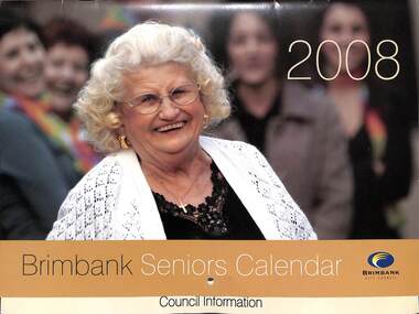 Sunshine and District Historical Society Incorporated
Ephemera - Brimbank Seniors Calendar 2008 - monthly photographs, Brimbank City Council
... Kathleen Elizabeth Henwood|Ray Heinze Brimbank Bicycle Users Group (BRIMBUG)|Claudia Dale Foster Care|Harold Gomez Anglo - India Community|Maureen Fitzpatrick & Luisa D'Agostia Western Art Group|Dawn Cox & robert Vargiu Community Bus|Claudette Daniag, Lita Abril-fandino, Anicia Tindogan, Crispina Llovido, Elsie Spiteri Filipino Australian Seniors Citizens Club|Linda Borg, Flora McKenzie, Mary Valsames, Beverly Smith, Crist Portelli Golden Oldies Walking Group|Margaret Cooke, Shirley Knight, Lyn Kieryczuk Rummikin|Santhana Selvendr Melbourne Murugan Cultural Centre|Ross Sandz, Frank Levens, Katherine Halliwell Chair Aerobics|Marlene Dedman Barbara Anderson Copperfields Walking Group And Volunteering|Apostolos Andreas, Kyriaki Papa, Georgia Christodoulou, Elli Efthimiou, Androula Christou Cyprus Greek Seniors Clun...City of Brimbank Resident Kathleen Elizabeth Henwood|Ray Heinze Brimbank Bicycle Users Group (BRIMBUG)|Claudia Dale Foster Care|Harold Gomez Anglo - India Community|Maureen Fitzpatrick & Luisa D'Agostia Western Art Group|Dawn Cox & robert Vargiu Community Bus|Claudette Daniag, Lita Abril-fandino, Anicia Tindogan, Crispina Llovido, Elsie Spiteri Filipino Australian Seniors Citizens Club|Linda Borg, Flora McKenzie, Mary Valsames, Beverly Smith, Crist Portelli Golden Oldies Walking Group|Margaret Cooke, Shirley Knight, Lyn Kieryczuk Rummikin|Santhana Selvendr Melbourne Murugan Cultural Centre|Ross Sandz, Frank Levens, Katherine Halliwell Chair Aerobics|Marlene Dedman Barbara Anderson Copperfields Walking Group And Volunteering|Apostolos Andreas, Kyriaki Papa, Georgia Christodoulou, Elli Efthimiou, Androula Christou Cyprus Greek Seniors Clun Brimbank Seniors Calendar 2008 - monthly photographs Ephemera Brimbank Seniors Calendar 2008 - monthly photographs Brimbank City Council ...Kathleen Elizabeth Henwood|Ray Heinze Brimbank Bicycle Users Group (BRIMBUG)|Claudia Dale Foster Care|Harold Gomez Anglo - India Community|Maureen Fitzpatrick & Luisa D'Agostia Western Art Group|Dawn Cox & robert Vargiu Community Bus|Claudette Daniag, Lita Abril-fandino, Anicia Tindogan, Crispina Llovido, Elsie Spiteri Filipino Australian Seniors Citizens Club|Linda Borg, Flora McKenzie, Mary Valsames, Beverly Smith, Crist Portelli Golden Oldies Walking Group|Margaret Cooke, Shirley Knight, Lyn Kieryczuk Rummikin|Santhana Selvendr Melbourne Murugan Cultural Centre|Ross Sandz, Frank Levens, Katherine Halliwell Chair Aerobics|Marlene Dedman Barbara Anderson Copperfields Walking Group And Volunteering|Apostolos Andreas, Kyriaki Papa, Georgia Christodoulou, Elli Efthimiou, Androula Christou Cyprus Greek Seniors Cluncity of brimbank, resident -
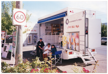 Musculoskeletal Health Australia (now held by the Glen Eira Historical Society)
Photograph - Group photo, 14/03/2022
... On the 14th of March, 2002, Arthritis Victoria had brought its Healthy Bones Bus to the Casterton community of far west Victoria for a Community Health Expo. ...Musculoskeletal Health Australia (now held by the Glen Eira Historical Society) 965 Glen Huntly Road Caulfield melbourne On the 14th of March, 2002, Arthritis Victoria had brought its Healthy Bones Bus to the Casterton community of far west Victoria for a Community Health Expo. ...On the 14th of March, 2002, Arthritis Victoria had brought its Healthy Bones Bus to the Casterton community of far west Victoria for a Community Health Expo. The bus was set up on the street outside the Casterton branch of Glenelg Libraries for maximum exposure to shoppers and other passers by. This photo depicts the Healthy Bones Bus parked on the street, near the library.COL photo of a large van parked in a street. The bus is set up and its wide side doors are open to reveal the contents inside. Three people are in attendance: two are seated on deck chairs while the other is standing, leaning back onto the steps leading up to the inside of the van. There are display boards set up on the footpath. The text on one of the van's doors is "Arthritis Victoria 1800 011 041", and on the other door, it is "Osteoporosis Victoria 1800 011 041". Below the text on each door are some large posters.[On a yellow sticky note, handwritten in dark blue ink] Casterton Community Health Expo 14/3/02arthritis victoria, av, osteoporosis victoria, ov, community health expo, information stall, education, outreach, fruit smoothy stall, healthy food, healthy diet, calcium, bone health, strong bones, casterton, glenelg libraries, 2002 -
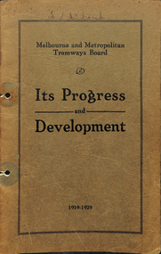 Melbourne Tram Museum
Book, Melbourne & Metropolitan Tramways Board (MMTB), "MMTB Its Progress and Development - 1919 - 1929", 1960's
... Looks at the first ten years of the Board from its formation by an Act of Parliament starting on 2/7/1919 - includes notes on the General Scheme, Industrial, The Board, power, traffic, medical examination, training, Workshops, tram noises, Wattle Park, replacement of Trams by Buses, buses, community services, finances, statistics and appendices. ...Looks at the first ten years of the Board from its formation by an Act of Parliament starting on 2/7/1919 - includes notes on the General Scheme, Industrial, The Board, power, traffic, medical examination, training, Workshops, tram noises, Wattle Park, replacement of Trams by Buses, buses, community services, finances, statistics and appendices. ...Book , green / brown stippled cover, with 32 pages on gloss paper centre stapled titled "MMTB Its Progress and Development - 1919 - 1929". Looks at the first ten years of the Board from its formation by an Act of Parliament starting on 2/7/1919 - includes notes on the General Scheme, Industrial, The Board, power, traffic, medical examination, training, Workshops, tram noises, Wattle Park, replacement of Trams by Buses, buses, community services, finances, statistics and appendices. pdf file text searchable when opened separately.Has "H S McComb" in ink along the top of the cover.trams, tramways, mmtb, buses, training, traffic control, statistics, wattle park, medical, finances -
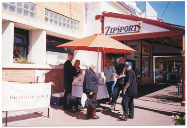 Musculoskeletal Health Australia (now held by the Glen Eira Historical Society)
Photograph - Group photo, 14/03/2022
... On the 14th of March, 2002, Arthritis Victoria had brought its Healthy Bones Bus to the Casterton community of far west Victoria for a Community Health Expo. ...Musculoskeletal Health Australia (now held by the Glen Eira Historical Society) 965 Glen Huntly Road Caulfield melbourne On the 14th of March, 2002, Arthritis Victoria had brought its Healthy Bones Bus to the Casterton community of far west Victoria for a Community Health Expo. ...On the 14th of March, 2002, Arthritis Victoria had brought its Healthy Bones Bus to the Casterton community of far west Victoria for a Community Health Expo. The bus was set up on the street outside the library for maximum exposure to shoppers and other passers by. This photo depicts a fruit smoothie stall outside the Casterton branch of Glenelg Libraries. It is unclear whether the stall was organised by Arthritis Victoria or by another party.COL photo of a small group of people gathered around a table beneath an outdoor umbrella in a shopping strip. There is a table with various items on it, such as a blender, a bottle of orange juice, and some information inside a clear plastic frame. There is an extension lead connecting the blender to an electric power outlet through an open window, and a large esky is evident behind the table, against the exterior wall of the building. The shop next door has a sign on the front which says, "EASTERN ELECTRICS" and another which says "SALES AND SERVICE". On the side of the shop's veranda roof is a sign which says, "ZIPSPORTS".arthritis victoria, av, osteoporosis victoria, ov, community health expo, information stall, education, outreach, fruit smoothy stall, healthy food, healthy diet, calcium, bone health, strong bones, casterton, glenelg libraries, 2002 -
 Eltham District Historical Society Inc
Photograph, Slab hut, Warrandyte, Warrandyte Mystery Tour, 29 May 1994, 29/05/1994
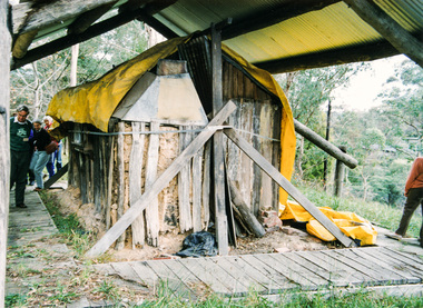
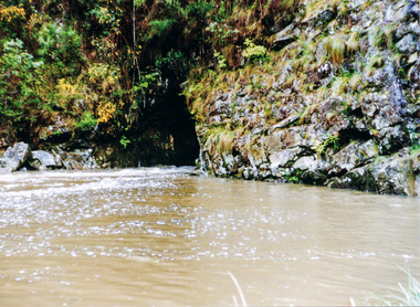
... "All Aboard" and we set off in the Warrandyte Community Bus (with the School Bus sign displayed at the rear) to learn about local places of "Pride and Joy” from Bruce our guide and Tom the driver. ..."All Aboard" and we set off in the Warrandyte Community Bus (with the School Bus sign displayed at the rear) to learn about local places of "Pride and Joy” from Bruce our guide and Tom the driver. ...[article by Bettina Woodburn in EDHS Newsletter No. 97, July 1994:] THE WARRANDYTE MYSTERY TOUR MAY 29TH 1994 - Members of the Eltham Historical Society met at the Old Post Office, now converted into the Warrandyte Historical Museum, for a picnic lunch on the sunny back verandah overlooking the shimmering Yarra River. Interesting photographs and artefacts filled various rooms outlining the history of this area, and told tales of Aboriginal and more recent neighbours of the Eltham Shire. The weather was calm, cloudy mostly with only occasional sunny patches, but it wasn't cold, although the autumnal leaf colours had changed to wintry brown. "All Aboard" and we set off in the Warrandyte Community Bus (with the School Bus sign displayed at the rear) to learn about local places of "Pride and Joy” from Bruce our guide and Tom the driver. Almost directly opposite we entered Whipstick Gully to explore the first of the district's hidden treasures - the Victory, one of the largest of the six or so major mines, past the old quarry now used for abseiling practice. By torchlight we entered the rocky hillside and saw the seams of quartz the miners had followed in their search for gold. Stamping batteries, and there was one in this gully, converted discarded rock into 'road metal'. Warrandyte is proud to be the first declared Goldfield in 1851, and one of the longest surviving, into the 1920s. A pleasant drive across the Bridge and along Bradley's Lane to Norman's Reserve brought us to see another Tunnel at Pound Bend through which the Yarra was diverted to allow about three miles of river-bed to be used for prospecting for alluvial gold. Still on this side of the river we visited the Old Slab Hut in Castles Road. This remnant of miners' housing is preserved because it had been incorporated into a weatherboard house, and saved from the bulldozers - a last minute reprieve, for preservation, by the National Trust. Devastating bush fires have destroyed other old cottages built of wattle and daub, with bark roofs and stone fire-places. The Cairn commemorating the disclosure of Gold Discovery at Warrandyte on June 30th 1851 beside Anderson's Creek Road was our next point of historical interest. We drove on to South Warrandyte and circled back to above the ford on Anderson's Creek to the entrance of the 4th Hill Mine. Again we crept along with our torches, careful of the low roof-rock, and side shafts. At a junction in a large cavity we were able to stand, look up a long air-vent which some 'cavers' climb down, and marvel at, and experience an aspect of a miner's life. Outside we heard the same bird songs, the trills and bell-pealing, saw the same straggly eucalypts, and a silver leafed wattle in flower, native grasses and ferns, and the neat present day houses, often of Warrandyte stone, perhaps veneered only. The day ended pleasantly, seeing more of the Yarra from Everard Drive, and the water rushing out of the Tunnel at Pound Bend, before returning to afternoon tea or coffee at the Museum. A great day for all concerned - many thanks to the Organisers.Colour photographslab hut, warrandyte, "warrandyte miner's cottage" -
 Eltham District Historical Society Inc
Photograph, Pound Bend tunnel, Warrandyte, Warrandyte Mystery Tour, 29 May 1994, 29/05/1994
... "All Aboard" and we set off in the Warrandyte Community Bus (with the School Bus sign displayed at the rear) to learn about local places of "Pride and Joy” from Bruce our guide and Tom the driver. ..."All Aboard" and we set off in the Warrandyte Community Bus (with the School Bus sign displayed at the rear) to learn about local places of "Pride and Joy” from Bruce our guide and Tom the driver. ...[article by Bettina Woodburn in EDHS Newsletter No. 97, July 1994:] THE WARRANDYTE MYSTERY TOUR MAY 29TH 1994 - Members of the Eltham Historical Society met at the Old Post Office, now converted into the Warrandyte Historical Museum, for a picnic lunch on the sunny back verandah overlooking the shimmering Yarra River. Interesting photographs and artefacts filled various rooms outlining the history of this area, and told tales of Aboriginal and more recent neighbours of the Eltham Shire. The weather was calm, cloudy mostly with only occasional sunny patches, but it wasn't cold, although the autumnal leaf colours had changed to wintry brown. "All Aboard" and we set off in the Warrandyte Community Bus (with the School Bus sign displayed at the rear) to learn about local places of "Pride and Joy” from Bruce our guide and Tom the driver. Almost directly opposite we entered Whipstick Gully to explore the first of the district's hidden treasures - the Victory, one of the largest of the six or so major mines, past the old quarry now used for abseiling practice. By torchlight we entered the rocky hillside and saw the seams of quartz the miners had followed in their search for gold. Stamping batteries, and there was one in this gully, converted discarded rock into 'road metal'. Warrandyte is proud to be the first declared Goldfield in 1851, and one of the longest surviving, into the 1920s. A pleasant drive across the Bridge and along Bradley's Lane to Norman's Reserve brought us to see another Tunnel at Pound Bend through which the Yarra was diverted to allow about three miles of river-bed to be used for prospecting for alluvial gold. Still on this side of the river we visited the Old Slab Hut in Castles Road. This remnant of miners' housing is preserved because it had been incorporated into a weatherboard house, and saved from the bulldozers - a last minute reprieve, for preservation, by the National Trust. Devastating bush fires have destroyed other old cottages built of wattle and daub, with bark roofs and stone fire-places. The Cairn commemorating the disclosure of Gold Discovery at Warrandyte on June 30th 1851 beside Anderson's Creek Road was our next point of historical interest. We drove on to South Warrandyte and circled back to above the ford on Anderson's Creek to the entrance of the 4th Hill Mine. Again we crept along with our torches, careful of the low roof-rock, and side shafts. At a junction in a large cavity we were able to stand, look up a long air-vent which some 'cavers' climb down, and marvel at, and experience an aspect of a miner's life. Outside we heard the same bird songs, the trills and bell-pealing, saw the same straggly eucalypts, and a silver leafed wattle in flower, native grasses and ferns, and the neat present day houses, often of Warrandyte stone, perhaps veneered only. The day ended pleasantly, seeing more of the Yarra from Everard Drive, and the water rushing out of the Tunnel at Pound Bend, before returning to afternoon tea or coffee at the Museum. A great day for all concerned - many thanks to the Organisers.Two colour photographswarrandyte, activities, pound bend -
 Sunshine and District Historical Society Incorporated
Archive - City of Sunshine
... Typed Report General Information on the City of Sunshine 1987 to 1988|Newspaper Article 13 October 1993 The Age How rubish tips can be a big turn on|Envelope Town Clerk Sunshine City Council|Flyer City of Sunshine Community Day Festival 23 April 1994|Brochure City of Sunshine City of the Future Community Meeting 5 March 1994 Moonee Valley|Brochure City of Sunshine Multicultural City of Victoria Community Meeting 14 September 1991 Moonee Valley|Brochure City of Sunshine The Conferring of The Freedom of Entry to the City of Sunshine Upon The First Try City of Sunshine Regional Cadet Unit on 16 May 1987|Brochure City of Sunshine The Conferring of The Freedom of Entry to the City of Sunshine Upon No 5 Flight Air Training Corps Tottenham 18 November 1989|Photograph and photocopies of building with handwritten notes 444 $136.89|Logo of City of Sunshine Victoria|Brochure Your share in Sunshine City of Sunshine A Progressive Municipality|Brochure City of Sunshine The Conferring of the Freedom of the City of Sunshine upon 5th and 6th Battalion The Royal Victoria Regiment 12 February 1994|Hand drawings with handwritten notes 441 $32.09|Hand drawings with handwritten notes 256 $12.64|Hand drawings with handwritten notes 258 $17.233|Hand drawings with handwritten notes 250 $15.60|Hand drawings with handwritten notes 260 $19.72|Hand drawings with handwritten notes 255 $8.26|Hand drawings with handwritten notes 440 $6.19|Hand drawings with handwritten notes 387 $34.09|Hand drawings with handwritten notes 259 $12.49|Brochure City of Sunshine Development Update October 1988|Newsletter Grapewine City of Sunshine Staff Newsletter June 1992|Typed Letter City of Sunshine Community Bus Information Sheet 21 March 1979|Map Greening Sunshine Current Work in Progress 1992 to 1993|Newspaper Article A Place in the Sun Exotic plants along Railway lines|Flyer Sunshine City Council News Vol 1 No 1 August 1974 Inflation Whats happening to Councils Money|Newspaper Article Footscray Advertiser 17 February 1917 Braybrook Council|Flyer Sunshine City Council News Vol 1 No 1 April 1975 Leaping into Sunshine New World|Flyer Sunshine your city August 1961 Facts you should know Administration commended|Flyer Sunshines Gardens Parks and Streets 1991 to 1992|Invitation sent 28 June 1982 Government Reception to farewell Governor General of the Commonwealth of Australia on 8 July 1982 Commissioner AG and Mrs Gillen at National Gallery of Victoria|City of Sunshine Crest Motto is By Industry|Flyer Sunshine City Burke and Wills Camel Cup 24 April 1994 on Massey Ferguson Harvester site|Booklet Sunshine Yearbook 1972 Suburban Services Directories and Yearbooks|Enrolment form City of Sunshine Holiday Programme 7 May to 18 May 1984|Christmas Wishes Card from Chief Secretary Victoria t0 GM Prendergast Christmas 1927|Typed Letter 1 January 1984 A Personal Invitation from the Mayor|Newspaper Article The Advocate 9 September 1992 Public to have say Brooklyn tug of war|Newspaper Article Local Government Focus Special Feature November 1986 The City of Sunshine Multicultural City of Victoria Message from the Mayor|Brochure City of Sunshine Municipal Profile|Brochure City of Sunshine Accommodating the Future A Strategy for Housing Needs|Brochure Sunshine City Centre Development|Photocopy Mayors City of Sunshine|Brochure Local Solutions to a Global Problem our gift to future generations GEC ALSTHOM Energy Park Hulett St Albion|Brochure Melbournes West on the Move Melbournes Western Region Profile|Brochure Sunshine District Centre Market Square Interchange Public Transport|Certificate of Speical Civic Service for the Municipality of Sunshine|Brochure New Municipal Offices City of Sunshine Victoria|Newspaper Article Sunshine Community 1972 Can you imagine what $800 Million dollars looks like|Brochure Shire of Braybrook Office Welcome Home tendered to Maidstone Returned Services Personnel 2nd August 1946|Brochure City of Sunshine Live work and recreate in Sunshine|Sunshine City Council No 7 Council Report|Section of Minutes 24 March 199 Sunshine Logo competition won by Mr Stephen Jones of Laverton|Photocopy of Mayoral Pendant presented to City of Sunshine by Cr AG Pennel JP to commemorate its proclamatonas a city 16 May 1951|Flyer City of Sunshine Corporation Logo 24 March 1992 The logo was chosen from 94 other logos submitted as part of a community competiiton to find a new corporate logo. ...City of Sunshine Typed Report General Information on the City of Sunshine 1987 to 1988|Newspaper Article 13 October 1993 The Age How rubish tips can be a big turn on|Envelope Town Clerk Sunshine City Council|Flyer City of Sunshine Community Day Festival 23 April 1994|Brochure City of Sunshine City of the Future Community Meeting 5 March 1994 Moonee Valley|Brochure City of Sunshine Multicultural City of Victoria Community Meeting 14 September 1991 Moonee Valley|Brochure City of Sunshine The Conferring of The Freedom of Entry to the City of Sunshine Upon The First Try City of Sunshine Regional Cadet Unit on 16 May 1987|Brochure City of Sunshine The Conferring of The Freedom of Entry to the City of Sunshine Upon No 5 Flight Air Training Corps Tottenham 18 November 1989|Photograph and photocopies of building with handwritten notes 444 $136.89|Logo of City of Sunshine Victoria|Brochure Your share in Sunshine City of Sunshine A Progressive Municipality|Brochure City of Sunshine The Conferring of the Freedom of the City of Sunshine upon 5th and 6th Battalion The Royal Victoria Regiment 12 February 1994|Hand drawings with handwritten notes 441 $32.09|Hand drawings with handwritten notes 256 $12.64|Hand drawings with handwritten notes 258 $17.233|Hand drawings with handwritten notes 250 $15.60|Hand drawings with handwritten notes 260 $19.72|Hand drawings with handwritten notes 255 $8.26|Hand drawings with handwritten notes 440 $6.19|Hand drawings with handwritten notes 387 $34.09|Hand drawings with handwritten notes 259 $12.49|Brochure City of Sunshine Development Update October 1988|Newsletter Grapewine City of Sunshine Staff Newsletter June 1992|Typed Letter City of Sunshine Community Bus Information Sheet 21 March 1979|Map Greening Sunshine Current Work in Progress 1992 to 1993|Newspaper Article A Place in the Sun Exotic plants along Railway lines|Flyer Sunshine City Council News Vol 1 No 1 August 1974 Inflation Whats happening to Councils Money|Newspaper Article Footscray Advertiser 17 February 1917 Braybrook Council|Flyer Sunshine City Council News Vol 1 No 1 April 1975 Leaping into Sunshine New World|Flyer Sunshine your city August 1961 Facts you should know Administration commended|Flyer Sunshines Gardens Parks and Streets 1991 to 1992|Invitation sent 28 June 1982 Government Reception to farewell Governor General of the Commonwealth of Australia on 8 July 1982 Commissioner AG and Mrs Gillen at National Gallery of Victoria|City of Sunshine Crest Motto is By Industry|Flyer Sunshine City Burke and Wills Camel Cup 24 April 1994 on Massey Ferguson Harvester site|Booklet Sunshine Yearbook 1972 Suburban Services Directories and Yearbooks|Enrolment form City of Sunshine Holiday Programme 7 May to 18 May 1984|Christmas Wishes Card from Chief Secretary Victoria t0 GM Prendergast Christmas 1927|Typed Letter 1 January 1984 A Personal Invitation from the Mayor|Newspaper Article The Advocate 9 September 1992 Public to have say Brooklyn tug of war|Newspaper Article Local Government Focus Special Feature November 1986 The City of Sunshine Multicultural City of Victoria Message from the Mayor|Brochure City of Sunshine Municipal Profile|Brochure City of Sunshine Accommodating the Future A Strategy for Housing Needs|Brochure Sunshine City Centre Development|Photocopy Mayors City of Sunshine|Brochure Local Solutions to a Global Problem our gift to future generations GEC ALSTHOM Energy Park Hulett St Albion|Brochure Melbournes West on the Move Melbournes Western Region Profile|Brochure Sunshine District Centre Market Square Interchange Public Transport|Certificate of Speical Civic Service for the Municipality of Sunshine|Brochure New Municipal Offices City of Sunshine Victoria|Newspaper Article Sunshine Community 1972 Can you imagine what $800 Million dollars looks like|Brochure Shire of Braybrook Office Welcome Home tendered to Maidstone Returned Services Personnel 2nd August 1946|Brochure City of Sunshine Live work and recreate in Sunshine|Sunshine City Council No 7 Council Report|Section of Minutes 24 March 199 Sunshine Logo competition won by Mr Stephen Jones of Laverton|Photocopy of Mayoral Pendant presented to City of Sunshine by Cr AG Pennel JP to commemorate its proclamatonas a city 16 May 1951|Flyer City of Sunshine Corporation Logo 24 March 1992 The logo was chosen from 94 other logos submitted as part of a community competiiton to find a new corporate logo. ...Typed Report General Information on the City of Sunshine 1987 to 1988|Newspaper Article 13 October 1993 The Age How rubish tips can be a big turn on|Envelope Town Clerk Sunshine City Council|Flyer City of Sunshine Community Day Festival 23 April 1994|Brochure City of Sunshine City of the Future Community Meeting 5 March 1994 Moonee Valley|Brochure City of Sunshine Multicultural City of Victoria Community Meeting 14 September 1991 Moonee Valley|Brochure City of Sunshine The Conferring of The Freedom of Entry to the City of Sunshine Upon The First Try City of Sunshine Regional Cadet Unit on 16 May 1987|Brochure City of Sunshine The Conferring of The Freedom of Entry to the City of Sunshine Upon No 5 Flight Air Training Corps Tottenham 18 November 1989|Photograph and photocopies of building with handwritten notes 444 $136.89|Logo of City of Sunshine Victoria|Brochure Your share in Sunshine City of Sunshine A Progressive Municipality|Brochure City of Sunshine The Conferring of the Freedom of the City of Sunshine upon 5th and 6th Battalion The Royal Victoria Regiment 12 February 1994|Hand drawings with handwritten notes 441 $32.09|Hand drawings with handwritten notes 256 $12.64|Hand drawings with handwritten notes 258 $17.233|Hand drawings with handwritten notes 250 $15.60|Hand drawings with handwritten notes 260 $19.72|Hand drawings with handwritten notes 255 $8.26|Hand drawings with handwritten notes 440 $6.19|Hand drawings with handwritten notes 387 $34.09|Hand drawings with handwritten notes 259 $12.49|Brochure City of Sunshine Development Update October 1988|Newsletter Grapewine City of Sunshine Staff Newsletter June 1992|Typed Letter City of Sunshine Community Bus Information Sheet 21 March 1979|Map Greening Sunshine Current Work in Progress 1992 to 1993|Newspaper Article A Place in the Sun Exotic plants along Railway lines|Flyer Sunshine City Council News Vol 1 No 1 August 1974 Inflation Whats happening to Councils Money|Newspaper Article Footscray Advertiser 17 February 1917 Braybrook Council|Flyer Sunshine City Council News Vol 1 No 1 April 1975 Leaping into Sunshine New World|Flyer Sunshine your city August 1961 Facts you should know Administration commended|Flyer Sunshines Gardens Parks and Streets 1991 to 1992|Invitation sent 28 June 1982 Government Reception to farewell Governor General of the Commonwealth of Australia on 8 July 1982 Commissioner AG and Mrs Gillen at National Gallery of Victoria|City of Sunshine Crest Motto is By Industry|Flyer Sunshine City Burke and Wills Camel Cup 24 April 1994 on Massey Ferguson Harvester site|Booklet Sunshine Yearbook 1972 Suburban Services Directories and Yearbooks|Enrolment form City of Sunshine Holiday Programme 7 May to 18 May 1984|Christmas Wishes Card from Chief Secretary Victoria t0 GM Prendergast Christmas 1927|Typed Letter 1 January 1984 A Personal Invitation from the Mayor|Newspaper Article The Advocate 9 September 1992 Public to have say Brooklyn tug of war|Newspaper Article Local Government Focus Special Feature November 1986 The City of Sunshine Multicultural City of Victoria Message from the Mayor|Brochure City of Sunshine Municipal Profile|Brochure City of Sunshine Accommodating the Future A Strategy for Housing Needs|Brochure Sunshine City Centre Development|Photocopy Mayors City of Sunshine|Brochure Local Solutions to a Global Problem our gift to future generations GEC ALSTHOM Energy Park Hulett St Albion|Brochure Melbournes West on the Move Melbournes Western Region Profile|Brochure Sunshine District Centre Market Square Interchange Public Transport|Certificate of Speical Civic Service for the Municipality of Sunshine|Brochure New Municipal Offices City of Sunshine Victoria|Newspaper Article Sunshine Community 1972 Can you imagine what $800 Million dollars looks like|Brochure Shire of Braybrook Office Welcome Home tendered to Maidstone Returned Services Personnel 2nd August 1946|Brochure City of Sunshine Live work and recreate in Sunshine|Sunshine City Council No 7 Council Report|Section of Minutes 24 March 199 Sunshine Logo competition won by Mr Stephen Jones of Laverton|Photocopy of Mayoral Pendant presented to City of Sunshine by Cr AG Pennel JP to commemorate its proclamatonas a city 16 May 1951|Flyer City of Sunshine Corporation Logo 24 March 1992 The logo was chosen from 94 other logos submitted as part of a community competiiton to find a new corporate logo. Designer ws Mr Steve Jones of Laverton.|Sunshine District Centre Aerial Perspective Market Sqaure : Pollard Reserve : The Overpass and Railway Line sketchcity of sunshine -
 Warrnambool and District Historical Society Inc.
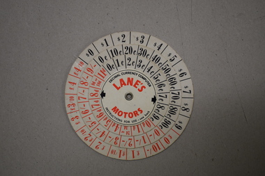
Instrument - Decimal Currency Converter, Ultra Publicity Pty Ltd, C 1966
... Alan Lane (d.1995) was prominent in Warrnambool as a businessman man, community leader and philanthropist. His businesses included a bus company, a taxi company and a travel agency. ...Alan Lane (d.1995) was prominent in Warrnambool as a businessman man, community leader and philanthropist. His businesses included a bus company, a taxi company and a travel agency. ...This decimal currency converter was produced about 1966 when the Australian currency was changed from the imperial system to the decimal system. It has been used by a Warrnambool businessman, Alan Lane to promote one of his businesses, Lane’s Motors and would have been given to business clients. Alan Lane (d.1995) was prominent in Warrnambool as a businessman man, community leader and philanthropist. His businesses included a bus company, a taxi company and a travel agency. His community services included involvement in the St. John Ambulance Brigade, the Rotary Club, the local Football League, the Warrnambool Art Gallery, the Performing Arts Centre, the Warrnambool Chamber of Commerce and the Warrnambool Council. The A.L. Lane Foundation was established with funds from his estate and continues to assist local projects and charitable causes. This item is of interest as a memento of the time when the Australian currency was converted to the decimal system and as a memento of the prominent Warrnambool community worker, Alan Lane. This is a card consisting of four circles of paper of different sizes joined in the centre with a metal clip. The smallest central piece of paper has advertising material and the other three pieces have red and black numbers, some of decimal currency notations and some of imperial currency notationsDecimal Currency Computer Instructions for Use See Back Lane’s Motors alan l. lane, warrnambool, a.l. lane foundation -
 Warrnambool and District Historical Society Inc.
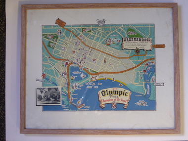
Advertising, Tourist Map of Warrnambool (framed x 2), 1950s
... The proprietor, Alan Lane, was a successful Warrnambool businessman who operated a Warrnambool and district bus service as well as his travel business. He was heavily involved in local community affairs being a Warrnambool Councillor for 18 years from 1952 to 1970 and President of the Warrnambool Chamber of Commerce for six years. ...The proprietor, Alan Lane, was a successful Warrnambool businessman who operated a Warrnambool and district bus service as well as his travel business. He was heavily involved in local community affairs being a Warrnambool Councillor for 18 years from 1952 to 1970 and President of the Warrnambool Chamber of Commerce for six years. ...These framed tourist maps came from the Lane Foundation so it is presumed that they were from the office of Lane’s Travel Service which operated from 205 Raglan Parade Warrnambool with the known dates, the 1950s and 1960s. The proprietor, Alan Lane, was a successful Warrnambool businessman who operated a Warrnambool and district bus service as well as his travel business. He was heavily involved in local community affairs being a Warrnambool Councillor for 18 years from 1952 to 1970 and President of the Warrnambool Chamber of Commerce for six years. He was a major donor to the Warrnambool Performing Arts Centre, the Warrnambool Art Gallery and the St. John of God Hospital and left the bulk of his estate to the Alan Lane Foundation which has contributed millions of dollars to local organizations and programs. Alan Lane died in 1995. These framed maps are of some interest as examples of the tourism maps used to promote the city and district in the 1950s and 60s. This is a tourist map of the Warrnambool C.B.D. and adjoining streets produced as an advertisement for Olympic Tyres. It is multi-coloured and has cartoon sketches of the main tourist attractions and pointers to attractions outside of the main city area. It includes an inset black and white photograph of the Warrnambool Botanic Gardens and an advertisement for Olympic Tyres. It is printed on a white background and is enclosed behind glass in a wooden frame of a light brown colour. It has a wire at the back for attachment to a wall. ‘Warrnambool – 163 miles from Melbourne – a popular tourist resort offering many holiday attractions – an ideal surfing beach with all modern facilities is avalable’ ‘Fit Olympic Tyres, Champions of the Road’ alan lane foundation, warrnambool tourism -
 Kiewa Valley Historical Society
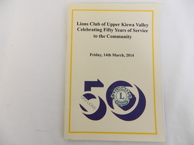
Book - Lions Club, Lions Club of Upper Kiewa Valley Celebrating Fifty Years of Service to the Community, 2014
... community. Its biggest success was the 'Snack Bar', a food outlet at Falls Creek, selling hot pies and coffee. From 1964 in a caravan, to 1965 - 1971 in a bus the snack bar operated, until it was sold in 1989. ...community. Its biggest success was the 'Snack Bar', a food outlet at Falls Creek, selling hot pies and coffee. From 1964 in a caravan, to 1965 - 1971 in a bus the snack bar operated, until it was sold in 1989. ...The Upper Kiewa Valley Lions Club has served the Kiewa Valley for 50 years - raising money for the community. Its biggest success was the 'Snack Bar', a food outlet at Falls Creek, selling hot pies and coffee. From 1964 in a caravan, to 1965 - 1971 in a bus the snack bar operated, until it was sold in 1989. The book also outlines their other projects and office bearers.The Upper Kiewa Valley Lions Club involved local people and local events giving an insight into the development of the area over the last 50 years. Yellow soft covered book fastened by 2 staples. Deep yellow line outlines the cover with black print of title and date. Thick black "50" with Lions logo in green is enclosed by the 0 (in the 50). Back cover - also outlined with a deep yellow line. On the top middle is "50" including the logo surrounded by the "0" and underneath the words "We Serve".On page 9 "Ian Howley 2010/11"lions club, upper kiewa valley, 50 years, service club, community, snack bar at falls creek, conquestathon -
Marysville & District Historical Society
THE TRIANGLE NEWS-VOL 39 NO 35-SEPTEMBER 14 2012
... community dancers...alexandra library september events...real estate...don giovanni opera comes to marysville...habitat for humanity public information meeting...busy times at marsyville for students...marysville primary school...councillor comment...murrindindi shire council...notice of special meeting of council...public notice...proposed sale of land...councils transport connection program...linking murrindindi...guide to permanent bus...Marysville & District Historical Society 39 Darwin Street Marysville yarra-valley-and-the-dandenong-ranges marysville victoria australia marysville football awards night marysville & district football & netball club villains what's on when in september intrepid triangle bushwalkers lantern making workshop marysville community market marysville cfa-first aid course level 1 creative triangle kellock lodge alexandra church notices venue change for mav councillor information sessions kidz zone youth impact narbethong-granton residents marysville golf report triangle golf club events myths & legends night friends of the library alexandra buxton primary school triangle shared trails project taggerty community project management advertisements community project pledge for taggerty dalton fiske foundation triangle community dancers alexandra library september events real estate don giovanni opera comes to marysville habitat for humanity public information meeting busy times at marsyville for students marysville primary school councillor comment murrindindi shire council notice of special meeting of council public notice proposed sale of land councils transport connection program linking murrindindi guide to permanent bus service thefts disappointing for castella community castella central park victorian concert orchestra narbethong community hall THE TRIANGLE NEWS-VOL 39 NO 35-SEPTEMBER 14 2012 ...marysville, victoria, australia, marysville football awards night, marysville & district football & netball club, villains, what's on when in september, intrepid triangle bushwalkers, lantern making workshop, marysville community market, marysville cfa-first aid course level 1, creative triangle, kellock lodge alexandra, church notices, venue change for mav councillor information sessions, kidz zone youth impact, narbethong-granton residents, marysville golf report, triangle golf club events, myths & legends night, friends of the library alexandra, buxton primary school, triangle shared trails project, taggerty community project management, advertisements, community project pledge for taggerty, dalton fiske foundation, triangle community dancers, alexandra library september events, real estate, don giovanni opera comes to marysville, habitat for humanity public information meeting, busy times at marsyville for students, marysville primary school, councillor comment, murrindindi shire council, notice of special meeting of council, public notice, proposed sale of land, councils transport connection program, linking murrindindi, guide to permanent bus service, thefts disappointing for castella community, castella central park, victorian concert orchestra, narbethong community hall -
Marysville & District Historical Society
THE TRIANGLE NEWS-VOL 4 NO 34-26 OCTOBER 1979
... bus to oaks day...happy birthday...lions club chariot challenge...for sale...r.s.l. day...floral carpet guides & brownies...clearance sale...wirreanda jottings...marysville cubs...anglican news...community...Marysville & District Historical Society 39 Darwin Street Marysville yarra-valley-and-the-dandenong-ranges marysville victoria australia thanks wirreanda rosters rev george edwards last service wirreanda tee shirts wirreanda ball wanted annual meeting hair dressing salon bus to oaks day happy birthday lions club chariot challenge for sale r.s.l. day floral carpet guides & brownies clearance sale wirreanda jottings marysville cubs anglican news community care centre wanted p/t gardener bonney's footy club presentation night fire brigade member for evelyn daylight savings reminder THE TRIANGLE NEWS-VOL 4 NO 34-26 OCTOBER 1979 ...marysville, victoria, australia, thanks, wirreanda rosters, rev george edwards last service, wirreanda tee shirts, wirreanda ball, wanted, annual meeting, hair dressing salon, bus to oaks day, happy birthday, lions club chariot challenge, for sale, r.s.l. day, floral carpet guides & brownies, clearance sale, wirreanda jottings, marysville cubs, anglican news, community care centre, wanted p/t gardener, bonney's, footy club, presentation night, fire brigade, member for evelyn, daylight savings reminder -
Marysville & District Historical Society
THE TRIANGLE NEWS-VOL 20 NO 33-20 AUGUST 1993
... community business...new committee...shopping trip...registered drivers...new drivers...bus...Marysville & District Historical Society 39 Darwin Street Marysville yarra-valley-and-the-dandenong-ranges marysville victoria australia marysville & district community care agm senior citizens buxton fire brigade for sale oregon woodgrain timber church notices triangle tid bits marysville indoor bowls tax accountant letters to the editor ratepayers' assocn public meeting the retreat wirreanda words food vendors deafness awareness week the hermitage music & arts red nose day triangle community business new committee shopping trip registered drivers new drivers bus bookings alpine liquor shire of alexandra gallipoli park management committee long term development plan marysville hotel THE TRIANGLE NEWS-VOL 20 NO 33-20 AUGUST 1993 ...marysville, victoria, australia, marysville & district community care agm, senior citizens, buxton fire brigade, for sale, oregon woodgrain timber, church notices, triangle tid bits, marysville indoor bowls, tax accountant, letters to the editor, ratepayers' assocn, public meeting the retreat, wirreanda words, food vendors, deafness awareness week, the hermitage music & arts, red nose day, triangle community business, new committee, shopping trip, registered drivers, new drivers, bus bookings, alpine liquor, shire of alexandra, gallipoli park management committee, long term development plan, marysville hotel -
Marysville & District Historical Society
THE TRIANGLE NEWS-VOL 36 NO 15-MAY 1 2009
... community...old hall site new building ideas...narbethong public hall committee...free bus...Marysville & District Historical Society 39 Darwin Street Marysville yarra-valley-and-the-dandenong-ranges marysville victoria australia postcards from morocco travel diary buxton residents what's on when narbethong & granton community meeting men's breakfast buxton progress assocn alexandra cinema narbethong community & tourism group mobile vet family fishing festival eildon pondage narbethong community old hall site new building ideas narbethong public hall committee free bus service free shoulder bags advertisements triangle distribution & fire relief centre murrindindi shire council councillor comment rebuilding our community first steps church notices welcome back to marysville greaternoosa-virgin blue big sister program victorian bushfire appeal grants marysville medical clinic alexandra community health in buxton temporary relocation opportunities begin buxton rural fire brigade fire restrictions wanted local musicians welcome back flags public health forum men's health merv hughes marysville golfers meet golfer peter thompson community recovery update mayor's chair update on buxton gym suggestion health & wellbeing dangers of isolation p/t vacancy business recovery officer new beginnings fellowship paster conrad & ruth halyburton marysville community facility THE TRIANGLE NEWS-VOL 36 NO 15-MAY 1 2009 ...marysville, victoria, australia, postcards from morocco, travel diary buxton residents, what's on when, narbethong & granton community meeting, men's breakfast, buxton progress assocn, alexandra cinema, narbethong community & tourism group, mobile vet, family fishing festival, eildon pondage, narbethong community, old hall site new building ideas, narbethong public hall committee, free bus service, free shoulder bags, advertisements, triangle distribution & fire relief centre, murrindindi shire council, councillor comment, rebuilding our community first steps, church notices, welcome back to marysville, greaternoosa-virgin blue big sister program, victorian bushfire appeal grants, marysville medical clinic, alexandra community health in buxton temporary relocation, opportunities begin, buxton rural fire brigade, fire restrictions, wanted local musicians, welcome back flags, public health forum men's health, merv hughes, marysville golfers meet golfer peter thompson, community recovery update, mayor's chair, update on buxton gym suggestion, health & wellbeing, dangers of isolation, p/t vacancy business recovery officer, new beginnings fellowship, paster conrad & ruth halyburton, marysville community facility -
Marysville & District Historical Society
THE TRIANGLE NEWS-VOL 36 NO 17-MAY 15 2009
... bus service...television available to marysville...triangle distribution & fire relief centre...alexandra open gardens weekend...councillor comment...state government about turn in bushfire assistance...two new grants...murrindindi shire council...economic development department...alexandra vacancy...marysville medical clinic...help & support get together...marysville golf club...thank you...gallipoli park...beauty escape mary kay cosmetics...alexandra visitors information centre...marysville & district lions club...community...Marysville & District Historical Society 39 Darwin Street Marysville yarra-valley-and-the-dandenong-ranges marysville victoria australia greaternoosa qld assisting recovery what's on when marysville & district historical society meeting new beginnings radio murrindindi marysville 98.5FM free tools marysville resource recovery centre cross country ski hire reopens postcard from paris advertisements alexandra resource recovery centre free bus service television available to marysville triangle distribution & fire relief centre alexandra open gardens weekend councillor comment state government about turn in bushfire assistance two new grants murrindindi shire council economic development department alexandra vacancy marysville medical clinic help & support get together marysville golf club thank you gallipoli park beauty escape mary kay cosmetics alexandra visitors information centre marysville & district lions club community bbq THE TRIANGLE NEWS-VOL 36 NO 17-MAY 15 2009 ...marysville, victoria, australia, greaternoosa qld assisting recovery, what's on when, marysville & district historical society meeting, new beginnings, radio murrindindi marysville, 98.5fm, free tools, marysville resource recovery centre, cross country ski hire reopens, postcard from paris, advertisements, alexandra resource recovery centre, free bus service, television available to marysville, triangle distribution & fire relief centre, alexandra open gardens weekend, councillor comment, state government about turn in bushfire assistance, two new grants, murrindindi shire council, economic development department, alexandra vacancy, marysville medical clinic, help & support get together, marysville golf club, thank you, gallipoli park, beauty escape mary kay cosmetics, alexandra visitors information centre, marysville & district lions club, community bbq -
Marysville & District Historical Society
THE TRIANGLE NEWS-VOL 36 NO 20-JUNE 5 2009
... community collection ponts for firewood & mulch...country touch winter news...lake mountain snow bus...Marysville & District Historical Society 39 Darwin Street Marysville yarra-valley-and-the-dandenong-ranges marysville victoria australia snow season marysville central refreshment marquee lake mountain james fraga cross country ski hire lake mountain ski hire marysville ski hire marysville bakery lake mountain ski resort premier john brumby 3aw neil mitchell broadcasting live from marysville stateline abc tv marysville recovery what's on when marysville cricket club free advice in marysville consumer affairs vic visiting marysville alexandra visitor information centre matdg agm marysville golf club advertisements lions triangle tool library open community collection ponts for firewood & mulch country touch winter news lake mountain snow bus councillor comment mobile library positions vacant true solar time open letter to murrindindi shire council marysville youth join in rebuild meeting news mums church notices mops regional achievement & community awards victorian senior of the year awards marysville medical clinic house signs ready for pick up THE TRIANGLE NEWS-VOL 36 NO 20-JUNE 5 2009 ...marysville, victoria, australia, snow season, marysville central refreshment marquee, lake mountain, james fraga, cross country ski hire, lake mountain ski hire, marysville ski hire, marysville bakery, lake mountain ski resort, premier john brumby, 3aw neil mitchell, broadcasting live from marysville, stateline abc tv marysville recovery, what's on when, marysville cricket club, free advice in marysville, consumer affairs vic visiting marysville, alexandra visitor information centre, matdg agm, marysville golf club, advertisements, lions triangle tool library open, community collection ponts for firewood & mulch, country touch winter news, lake mountain snow bus, councillor comment, mobile library, positions vacant, true solar time, open letter to murrindindi shire council, marysville youth join in rebuild, meeting news mums, church notices, mops, regional achievement & community awards, victorian senior of the year awards, marysville medical clinic, house signs ready for pick up -
Marysville & District Historical Society
THE TRIANGLE NEWS-VOL 36 NO 31-AUGUST 21 2009
... community hall...football training at marysville...murrindindi library service present on the couch...crossways inn...victorian bushfire relief fund...murrindindi craft gathering...holmesglen tafe...marysville country club...welcome strangers...alexandra cinema...mayors chair...marysville art show...your health and wellbeing...creative triangle meeting...steavenson falls bus...Marysville & District Historical Society 39 Darwin Street Marysville yarra-valley-and-the-dandenong-ranges marysville victoria australia jo and sharon bourke new home on old site advertisements councillor comment sp ausnet manages bushfire affected trees safe power network mops goal posts for trevor harrow oval church notices position vacant murrindindi council appreciation notice to taggerty hall buxton community hall football training at marysville murrindindi library service present on the couch crossways inn victorian bushfire relief fund murrindindi craft gathering holmesglen tafe marysville country club welcome strangers alexandra cinema mayors chair marysville art show your health and wellbeing creative triangle meeting steavenson falls bus tours working bees at marysville golf club THE TRIANGLE NEWS-VOL 36 NO 31-AUGUST 21 2009 ...marysville, victoria, australia, jo and sharon bourke, new home on old site, advertisements, councillor comment, sp ausnet manages bushfire affected trees, safe power network, mops, goal posts for trevor harrow oval, church notices, position vacant murrindindi council, appreciation notice to taggerty hall, buxton community hall, football training at marysville, murrindindi library service present on the couch, crossways inn, victorian bushfire relief fund, murrindindi craft gathering, holmesglen tafe, marysville country club, welcome strangers, alexandra cinema, mayors chair, marysville art show, your health and wellbeing, creative triangle meeting, steavenson falls bus tours, working bees at marysville golf club -
 Orbost & District Historical Society
book, The Queen in Victoria, 1954
... buses left the Orbost post Office at 6.a.m. to "Join in Acclaiming Our Gracious Queen" in Sale. An estimated 35,000 Gippslanders welcomed the Her Majesty, the Queen and the Duke of Edinburgh. (info. from S.R.M. March 2, 10, 1954. A three guinea prize was offered for an essay on the royal visit. This item reflects the interest in the royal family to Australians at this time as well as the general feeling of respect and admiration felt by the rural communities ...In June 1953 , Elizabeth II was crowned Queen of the United Kingdom, Canada, Australia, New Zealand, South Africa, Ceylon (now Sri Lanka), and Pakistan, and became the Head of the Commonwealth. Her Majesty Queen Elizabeth the Second and His Royal Highness the Duke of Edinburgh visited Victoria from 24th February to 9th March, 1954. The Argus was a morning daily newspaper, established in 1846 and closing in 1957. On 28 July 1952, The Argus became the first newspaper in the world to publish colour photographs in a daily paper. A large contingent of 160 students in a convoy of six school buses left the Orbost post Office at 6.a.m. to "Join in Acclaiming Our Gracious Queen" in Sale. An estimated 35,000 Gippslanders welcomed the Her Majesty, the Queen and the Duke of Edinburgh. (info. from S.R.M. March 2, 10, 1954. A three guinea prize was offered for an essay on the royal visit. This item reflects the interest in the royal family to Australians at this time as well as the general feeling of respect and admiration felt by the rural communities towards the British Royal Family, especially towards Queen Elizabeth II.A hard covered book of 77 pp. The front cover is black with "E11R" in gold print. It is a pictorial story of Queen Elizabeth 11's visit to Victoria in 1954 - 24 February - 9 March.book-the-queen-in-victoria royalty -
 Orbost & District Historical Society
register, after 1888
... bus service took them to Orbost in 1949. The school building was transferred also and became an integral part of Orbost State School. This school record is of immediate interest and value to the pupils and staff who have learned and taught in theJarrahmond State School. The record also has a much wider significance, to the community ...Jarrahmond State School, 2745, opened on March 19 1886 with Campbell Mackay as the head teacher and operated on apart-time basis with Orbost State School, 2744. The first building, erected on the bank of the Snowy River, was moved in approximately 1892 to McLeod's Lane. In 1914 a new building was erected by George Lurkins, and this catered for the local children until a school bus service took them to Orbost in 1949. The school building was transferred also and became an integral part of Orbost State School.This school record is of immediate interest and value to the pupils and staff who have learned and taught in theJarrahmond State School. The record also has a much wider significance, to the community in which the school is situated, as a record and research tool.A hand-written school register for Jarrahmond State School. It records the pupils enrolled 1888 until 1907. It has a brown cover with lined pagess which are ruled in tables to list pupils.jarrahmond education school-register mackay-campbell -
 Eltham District Historical Society Inc
Photograph, Liz Pidgeon, EDHS Heritage Walk: Shillinglaw Farm, Eltham, 2 September 2023
... A number of stops were made to look at maps and early photos illustrating the gradual reduction of the farm area and the early history of the railway and other community uses, that occupied parts of the site. 2023-09-02 Activities Eltham Eltham District Historical Society Heritage Excursion Shillinglaw farm 895 Main Road Amplifon Andrew Park Andrew Pocket Park Arthur Street Bar de Tapas Barber shop Barry Plant estate agent Blockbuster Bus depot Car Park Carparks Central Park Cleaver & Co Hair Commonwealth Bank Crust Pizza Divine Bridal Dr Ash Constance Dudley Street Eltham Book Shop Eltham Convenience Store Eltham Fire Station Eltham Library Eltham Newsagency Eltham Optical Eltham Railway Station Eltham Shops Fay Bridge Fire Bell Flagpole Flight Centre Grill'd Information sign ISO Chook Jellis Craig estate agent Judge Book Village Kebab Nation KX Pilates La Zanyas Liquorland Little Drop of Poison Lorraine Jones & Associates Solicitors Luck Street Machan Indian restaurant Main Road Mecho en Mexico Missing Gorilla Morrison Kleeman Real Estate Pavilion Menswear Platform 3095 Playtherapy Melbourne Pryor Street Ray White Real Estate Restaurants Sage Bulk Whole Foods Shillinglaw Trees Sign Snap Fitness Southern Cross Medical Imaging Specsavers St Laurence Lane St Vincents Care Service Thompson's Pharmacy Todaro United Service Station vyve body & skin Welcome to Eltham Town Westpac Bank Yang's Kitchen Youth Road 71 images - born digital EDHS Heritage Walk: Shillinglaw Farm, Eltham Photograph Photograph Liz Pidgeon ...On Saturday September 2, 2023, Russell Yeoman led a group of 22 society members and interested others on a walk following trhe bounadries of the original Shillingalw farm. Commencing at the corner of Panther Place and Library Place, we proceeded up to Shillinglaw Cafe then the Shillinglaw trees at the former Eltham Shire Office site then along Main Road to the fire station then throughh St Laurence Lane and uinder the railway line , along Diamond Street then return via the Diamond Creek trail behind Andrew Park. The actual farm boundary went past the creek and further up the hill. The original farm comprised lot 90 of Holloway’s 1851 subdivision of Little Eltham. Its area was 30 acres lying east of the Diamond Creek and north of Henry Street. A number of stops were made to look at maps and early photos illustrating the gradual reduction of the farm area and the early history of the railway and other community uses, that occupied parts of the site.2023-09-02, activities, eltham, eltham district historical society, heritage excursion, shillinglaw farm, 895 main road, amplifon, andrew park, andrew pocket park, arthur street, bar de tapas, barber shop, barry plant estate agent, blockbuster, bus depot, car park, carparks, central park, cleaver & co hair, commonwealth bank, crust pizza, divine bridal, dr ash constance, dudley street, eltham book shop, eltham convenience store, eltham fire station, eltham library, eltham newsagency, eltham optical, eltham railway station, eltham shops, fay bridge, fire bell, flagpole, flight centre, grill'd, information sign, iso chook, jellis craig estate agent, judge book village, kebab nation, kx pilates, la zanyas, liquorland, little drop of poison, lorraine jones & associates solicitors, luck street, machan indian restaurant, main road, mecho en mexico, missing gorilla, morrison kleeman real estate, pavilion menswear, platform 3095, playtherapy melbourne, pryor street, ray white real estate, restaurants, sage bulk whole foods, shillinglaw trees, sign, snap fitness, southern cross medical imaging, specsavers, st laurence lane, st vincents care service, thompson's pharmacy, todaro, united service station, vyve body & skin, welcome to eltham town, westpac bank, yang's kitchen, youth road -
Glen Eira Historical Society
Document - CAULFIELD CITIZENS ADVICE BUREAU
... Rudzki Brian Cr Milne Sandy Fusion Moyle Gwen Westlake Margaret Gild Anne Herszfeld Henry Lee Alf Lee Rae Peters Leanie Pratt Lillian Trumble Joan Wise John Nicholls Harry Grist Molly Payne Ruth Victorian Association of Citizens’ Advice Bureaus Emergency Relief funds Community buses Sinisgalli John Aroni Beni Chisholm John Erlichster George Folkers Herman Jackson Ross Kraus Michael Lewis Ray Oliver Michael Romer Andrew Simons Adrian Smith Simon Legal Advice Services Solicitors Budget Advisory Service Voluntary Workers Sanders Kathy Allan Bill Bible Richard Bilston Ron Birch Harry Coad Laurie Durra Frank Glass Alf Gild Ann Grew Doreen Hawker Harry Hollow Neil Hingert Lorna Jack Ian Jones Alf Mann Gordon Mansfield Joan Marks Yvonne Menzies Edna Ohis Wil Powell Dave Pate Gwen Pentland Dilys Simmons Dianne Ward George Whitehead Richard Wills Anne Local Government Aged People Bullen Rose Culkan Stephanie Dukes Claire Klinger Rosa Lambert Douglas Sheehan Jean Trodd Carrie Brady Vera Bristow Joyce Byrne Enid Cornall-Reilly Patience Cornall-Reilly Arthur Rowland Alan Caulfield City Council Hostels Elsternwick Caulfield Festival Caulfield Park Maple Street St. ...This file contains 2 items: 1/Original copy of 17th Annual Report of city of Caulfield Citizens Advice Bureau September 1987. Report includes Agenda for the Annual General Meeting held at City Hall on Wednesday 30091987, list of office bearers, minutes of the previous AGM, election of Management Committee and presentation of Life memberships plus list of Legal Advice Service solicitors. 2/Original copy of Agenda and 25th Annual Report for Caulfield Citizens Advice Bureau Incorporated presented to the Annual General meeting on 30/08/1995 at Caulfield City Hall. Report includes financial statement F Y E 30/06/1995, details of President’s Report, minutes of previous AGM in 1994.caulfield, citizen’ advice bureau, meetings, caulfield city hall, annual report, grants, edwards mavis, hocking john, green carol, coad thelma, harry carol, hession dorothy, lambert sam, moorrees joyce, ravenscroft jean, rowland dorothy, tyrell audrey, snowball betty, telford nancy, jelleff jenny, kay yvonne, bannister jean, fooks john, allsop doris, bullivant trudy, capek irene, carr fred, cairncross gwen, gorden peg, daniels maurice, davey dulcie, gresham greta, gresham john, hicks margaret, hind lillian, jacombs ken, joseph marion, kinross jo, lukies arthur, lukies noela, mander clive, miles glad, moser ellen, popper irene, poynton ray, splatt betty, stewart may, telford nancy, wray shirley, watson beth, chapman john, felder ilse, helman anne, mccarthy marie, richardson elizabeth, steward derek, williams marcia, blacher rosa, heyman manfred, tanner ted mla, dunstan don. cr, martens veronika cr, legge mary, crossley rosemary, malvern citizens’ advice bureau, deal communication centre, child joan mp, macphee ian hon mp, shipton roger mp, mccutcheon andrew mla, campbell jack, mayor, mayoress, campbell mrs., rudzki brian cr, milne sandy, fusion, moyle gwen, westlake margaret, gild anne, herszfeld henry, lee alf, lee rae, peters leanie, pratt lillian, trumble joan, wise john, nicholls harry, grist molly, payne ruth, victorian association of citizens’ advice bureaus, emergency relief funds, community buses, sinisgalli john, aroni beni, chisholm john, erlichster george, folkers herman, jackson ross, kraus michael, lewis ray, oliver michael, romer andrew, simons adrian, smith simon, legal advice services, solicitors, budget advisory service, voluntary workers, sanders kathy, allan bill, bible richard, bilston ron, birch harry, coad laurie, durra frank, glass alf, gild ann, grew doreen, hawker harry, hollow neil, hingert lorna, jack ian, jones alf, mann gordon, mansfield joan, marks yvonne, menzies edna, ohis wil, powell dave, pate gwen, pentland dilys, simmons dianne, ward george, whitehead richard, wills anne, local government, aged people, bullen rose, culkan stephanie, dukes claire, klinger rosa, lambert douglas, sheehan jean, trodd carrie, brady vera, bristow joyce, byrne enid, cornall-reilly patience, cornall-reilly arthur, rowland alan, caulfield city council, hostels, elsternwick, caulfield festival, caulfield park, maple street, st. johns uniting church elsternwick, caulfield contract, regent community for the elderly, caulfield hospital, royal district nursing service, mence wendy, gubieski joanne, preston dennis, ross moya, hall chloe, patience geoff, o’reilly mary, wraight geoff, thompson john, britton cath, thompson laurel, ross erwin, chapman john, carnie elza, coutts fay, goodman dianne, groat shirley, mclean phyllis, may tallilah, o’neil barbara, rosauer tom, shmerling lane, wedgwood amanda, gartside sandy, bucker ille, anderson ian, bonvicin rita, bridges judy, brooks lisa, bull rita, chin simone, ethell margaret, coupe jilie, klinger rosa, hogan tamara, harcourt-king judaline, lipp jonathan, mclver ken, murphy francis, mueller britt, moray debra, pinter sarolta, mctwerrey kay, nicholas norma, rae nicolle, simmons shirley, sumner laurie, bevis phyllis, cader estelle, crerar dorothy, egan hazel, gregoric kerry, glouzman kon, johnston peter, kamer john, lalacona flora, law russ, lipovetsky sergey, moroney dawn, kieth parsonson, pierce lorna, strickland joan, hall michael, mcgregor allan, shalit barbara, symons ian, community information centre, victorian association of community information centres (vacic), st. giles presbyterian church murrumbeena, st. mary’s anglican church caulfield, st. patrick’s catholic church murrumbeena, caulfield-elsternwick ecumenical ministry network, ladies probus club of caulfield, donovan mrs., windley mrs., van der vlies mrs. p., gorden p., gorden g., city of caulfield, barrett james cr, gold nicholas cr, welsh heather cr, boyle barry, barker ann, crean simon m.h.r., oxenbould wenzel, ashton matthew, lawrence mark, holding c. m.h.r., asher l. m.l.c., brideson a. m.l.c., guest j. m.l.c., biggs e. cr, grossbard a. cr, rogers a., terry g., va.c.a.b., coburn d., rodgers j., kelly j., caulfield community care, trevorrow a., trevorrow d., gleeson j., carnegie resource centre, elsternwick library, milne d., lister i., stone marjorie, larkin mary, patience jean, volunteer aid service, monitoring and social support service, community transport service, caulfield citizen advice bureau incorporated, community organisations -
Glen Eira Historical Society
Photograph - Elsternwick
... Community... Laundries... Mr. & Mrs. Darbyshires Milkbar... St. Johns Church... Kooyong Road... Hasseles Garage... Garages... Royal Parade... Glenhuntly... Camden... Hawthorn Road... Blacksmiths... Camden Town... Dolls Hospital... Caulfield State School 773... Independent Picture... Theatres... Camden Theatre... Southern Indoor Bowl Centre... Larch Street... Montessorie School... Collins Milk Bar... Milk Bars... Collins Lin... Hartrick Miss... Armond Mr.... Lennie Mr.... Rothells Sausage Factory... North Road... Red Bus...Community Laundries Mr. & Mrs. Darbyshires Milkbar St. Johns Church Kooyong Road Hasseles Garage Garages Royal Parade Glenhuntly Camden Hawthorn Road Blacksmiths Camden Town Dolls Hospital Caulfield State School 773 Independent Picture Theatres Camden Theatre Southern Indoor Bowl Centre Larch Street Montessorie School Collins Milk Bar Milk Bars Collins Lin Hartrick Miss Armond Mr. Lennie Mr. Rothells Sausage Factory North Road Red Bus ...This file contains three items. Photocopied and three page retyped article, undated c.1930s and source unknown from Real Estate Agent Philippe Batters 03/09/1997. Three page document from Keith James Smith, undated, on research on Elsternwick and Glen Huntly Road shops and traders. Three articles from THE AGE 13/05/2000 and 15-16/02/2013 and MELB BAYSIDE WEEKLY 03/11/2010 giving snap shots of Elsternwick housing and facts.batters philippe, real estate agents, elsternwick, paddocks, glen huntly road, walter kelly, elsternwick park, slaughter yards, glen eira roads, point ormond, glenhuntly railway station, nepean highway, grange road, holdsworth’s jewellers, staniland grove, coles store, shops, orrong road, fosseys, hattams mensware, woolworths, dalgarnos crockery and kitchenware, chapmans gifts, garth’s shoe store, garth jack, allen’s furniture and auction rooms, elsternwick market, adam’s cakes, mr. green’s pet shop, turner mr., grocer shop, moores lendring library, hopetown gardens, gardens, jack hatheralls butchershop, butchers, chinese laundry, chinese community, laundries, mr. & mrs. darbyshires milkbar, st. johns church, kooyong road, hasseles garage, garages, royal parade, glenhuntly, camden, hawthorn road, blacksmiths, camden town, dolls hospital, caulfield state school 773, independent picture, theatres, camden theatre, southern indoor bowl centre, larch street, montessorie school, collins milk bar, milk bars, collins lin, hartrick miss, armond mr., lennie mr., rothells sausage factory, north road, red bus service transport, furlonger miss, dance studio, moran and cato grocery, cato family, newsagent, tozer brook, furniture store, green gables american style soda fountain and milk bar, hoyts renown theatre, state savings bank, riddell parade, clarence street, aileen avenue, smith keith james, camden town, sports club, peer gary, gary peer & associates, brukarz jack, ray white real estate, real estate agents, classic cinema theatres, st. george’s road, elizabeth street, allison road, gladstone park, myrtle street, victoria street, caulfield, st kilda east, lisbon house, orrong road, house names, rippon lea estate, caulfield south, carnegie, gordon street, carre street, main street, clarence street, elsternwick club, jewish holocaust museum, daily planet, brothels, wesley college, elsternwick primary, st. joseph’s primary, scholem aleichen college, liebler yavneh, hopetoun gardens, harleston park -
Glen Eira Historical Society
Document - ROTARY CLUB OF CAULFIELD
... Community Market... Koornang Uniting Church... Murrumbeena Road... Welsh Heather... Robinson David... Kesselschmidt Sima... Potasz Sophie... Southwick David... Cheyne Gordon... Ryall Keith... Arianti Listy... Westbrook Natasha... Pollard Bob... Hancock Irey... Lovett Jack... Cooper Alby... Rundle John... Patkin Nehama... McMullen Adele... Douglas Jennie... Preston Mark... Resubal Loreto... Gifu Vase... Aoki Seiichi... Operation Firewood... Alfred Hospital... Bus...Eldridge Hannah Cottral Anne Abdullahi Khalid Gostin Cassie Podlabeniouk Lena Diyab Ahmed Draca Julijana Pevkoski Danilla Wooster Heath Lesar Dion Sansoni Rachel Leatham Chelsea Townsend Jessie Barker Megan Fitzgerald Megan Maokhamphiou Anthony Smith Naomi Fraser Sue-Ellen White Tanya Murrumbeena Community Market Koornang Uniting Church Murrumbeena Road Welsh Heather Robinson David Kesselschmidt Sima Potasz Sophie Southwick David Cheyne Gordon Ryall Keith Arianti Listy Westbrook Natasha Pollard Bob Hancock Irey Lovett Jack Cooper Alby Rundle John Patkin Nehama McMullen Adele Douglas Jennie Preston Mark Resubal Loreto Gifu Vase Aoki Seiichi Operation Firewood Alfred Hospital Bus of Knowledge Australia Day Breakfast Bethlehem Hospital Caulfield Hospital Document ROTARY CLUB OF CAULFIELD ...This file contains 13 official documents pertaining to the Rotary Club of Caulfield: 1/A typewritten copy of the constitution of the Rotary Club of Caulfield (undated). Said document is essentially an instruction manual detailing how the Club is to be administered and the duties of officials. 2/A page (unclear if intended for use as a poster or letter) announcing a Business Persons Breakfast to be held at St. Anthony’s Parish Hall on 19/11/1986, wherein Jeff Kennett, M.L.A., Leader of the Opposition of the Parliament of Victoria, will deliver a speech titled ‘Responsibility Before Rights’. 3/A booklet announcing the 25th anniversary celebration of the Rotary Club of Caulfield, to be held at Tudor Court on 24/02/1987. Contains the menu, national anthem, programme, and two lists – one of the founding members of the Club and one of the extant members of the Club. 4/Two copies of a booklet announcing a dinner, to be held at Tudor Court on 10/11/1987, wherein charter will be presented to the Rotary Club of Caulfield-Rosstown by District Governor Ian Knight. Contains a list of extant staff, the menu, the programme, a description of the history of the ‘Wembley Wheel of Friendship’, a list of charter members, and an account of the etymology of the name ‘Rosstown’. 5/Two copies of a page featuring four items of relevance to the Rotary Club of Caulfield. The first is an article (titled ‘Rotary scholar makes it’, author unspecified, source unspecified, undated) about Club scion Mark Collard receiving an MBA from Clarkson University. The second is an article (titled ‘New Caulfield Rotary’, author unspecified, source unspecified, undated) about the presentation dinner to which item 7 pertains. (This article is not present in its entirety, trailing off at the end.) The third is an announcement of a ‘progressive dinner’ to be held on 28/11/1987, also containing an announcement of a bicentennial conference to be held on 19/03/1988. The fourth is an announcement of what appears to be the initiation of some sort of historical re-enactment, the proceeds of which will fund the Rotary Club’s ‘Polio Plus’ project. A title (‘A Long Haul Through Caulfield’) suggests this item may be the header section of an article about said event, but if so, the remainder is not present. Contains three black-and-white photographs; one of Collard with an unidentified woman (presumably his wife), one of Club President Howie Dunlop congratulating Charter President Geoff Oscar, and one of some men riding on a horse-drawn cart. 6/Two copies of a booklet announcing a President Changeover Dinner, to be held on 28/06/1988. Contains the menu, programme, and a list of extant members. 7/Two copies of the weekly bulletin of the Rotary Club of Caulfield, dated 28/06/1988. Contains lists of faculty, notification of the Club’s decision to admit women, notification of upcoming events, a biography of guest speaker Fred Epstein, and a list of the times and places of alternative meetings. 8/Two photocopied statements of the receipts and expenditure of the Rotary Club of Caulfield, one for the period 01/10/1989 – 30/06/1990, and one for the period 01/07/1990 – 27/08/1990. 9/The photocopied minutes of a New Members Committee Meeting of the Rotary Club of Caulfield, dated 02/08/1990. Objects of discussion include fundraising methods and application of funds. 10/A booklet announcing Change Over Night, dated 21/06/1994. Contains the programme, menu, national anthem, and a list of extant faculty. 11/4 unbound pages announcing the winners of the Rotary Youth Photographic Awards, dated 1995 (a more specific date than this is not given). (Pages contain no photographs.) 12/A small note announcing the Murrumbeena Community Market, to be held on 04/12/2010, of which the Rotary Club of Caulfield is one of the sponsors. 13/A booklet announcing a dinner to celebrate the 50th anniversary of the Rotary Club of Caulfield, to be held on 23/02/2012. Contains the programme, menu, a list of past presidents, a description of the history of the Gifu Vase (a trophy in the Club’s possession), and a list of some of the charity projects the Club has been engaged in.rotary club of caulfield, clubs and associations, charitable organisations, kennett jeff m.l.a., st. anthony’s parish hall, grange road, neerim road, glenhuntly, festivals and celebrations, tudor court, gray robin, baird jack, lord john, king john, crittenden doug, gelme anthony, hunkin ed. rev., fryer roy, quine john, bedford f., bell jim, bunny d., cripps e., don john, epstein fred, hattam j., howard w., kerry g., kumnick j., kurrie s., lord l., morrison charles, nelson h., parton willis, perry bruce, pollard r., price f., skuse e., stillwell g., tilley norman, tomlinson charles, watson don, webster j., wilson duncan, fincher roy, wheller john, allen selwyn, christopher don, cohen godfrey, davis keith, davis lloyd, dornbierer w., dunlop howie, fillmore wally, ford john, ford peter, forshaw ken, gales brian, green myer, hind jim, humphreys john, hunter ian, lewis ray, melville jack, oscar geoff, penaluna harry, perlen louis, rampling ross, ronaldson keith, sherlock max, sicklemore graham, smith barry, stapleton ted, summers ron, tovey david, rotary club of caulfield-rosstown, knight ian, tudor court, kooyong road, bellmaine mark, langfelder kurt, morris rob, rome graeme, alma club, wilks street, wills david, blankfield mark, awards, wembley wheel of friendship, bellmaine loretta, cunningham david, cunningham jean, davis pam, davis rex, davis judith, forshaw hannah, graham jeremy, graham kara, hassing andre, hassing arlette, jacobs frank, jacobs june, langfelder judy, morris robert, morris angela, nettlebeck rosalie, oscar enid, rattray john, rattray diana, rome lorraine, sarah ted, sarah denise, sherlock helen, smith suzanne, stapleton jackie, turner brook, turner vicki, tuhiwai tamati, tuhiwai ravina, will arnold, will claire, rosstown, ross william murray, rosstown sugar works, collard mark, rotary foundation, keller chuck, campbell felicitie mrs., campbell jack cr., knight genny, albury civic centre, green tess, tantram avenue, quine gwen, beaver street, rosalind ray, rosalind lweis, devon street, little company of mary hospital, polio plus, smith ian, jackson adrian, miller peter, spence bert, wheller denise, coffey bill, financial documents, receipts, gilmartin e., moran d., kaan a., fillmore wal, coleman peter, coleman moyrha, wesley college elsternwick big band, puddy mark, fradkin barry, fitzgerald gerald, renton robert, herschberg gedeon, kinston david, montgomery peter, dawes shane, silberberg henry, zazryn ben, cohen michael, rotary youth photographic awards, photographic competitions, photography, terry ted mr., terry e. a. mr., eldridge hannah, cottral anne, abdullahi khalid, gostin cassie, podlabeniouk lena, diyab ahmed, draca julijana, pevkoski danilla, wooster heath, lesar dion, sansoni rachel, leatham chelsea, townsend jessie, barker megan, fitzgerald megan, maokhamphiou anthony, smith naomi, fraser sue-ellen, white tanya, murrumbeena community market, koornang uniting church, murrumbeena road, welsh heather, robinson david, kesselschmidt sima, potasz sophie, southwick david, cheyne gordon, ryall keith, arianti listy, westbrook natasha, pollard bob, hancock irey, lovett jack, cooper alby, rundle john, patkin nehama, mcmullen adele, douglas jennie, preston mark, resubal loreto, gifu vase, aoki seiichi, operation firewood, alfred hospital, bus of knowledge, australia day breakfast, bethlehem hospital, caulfield hospital -
 Bendigo Historical Society Inc.
Document - FOSTERVILLE GOLD MINE COLLECTION: OPEN DAY 2019
... Open Day activities include: bus tours, technical services display, geology, exploration, processing, community and environment display, minerals council of Australia, Swick drilling, Central Deborah Gold Mine, Face painting, Goldfields Re-vegetation, Delecca's hire equipment, MacMahon underground mining services, Sandvik, and ISH24 safety specialists. ...Open Day activities include: bus tours, technical services display, geology, exploration, processing, community and environment display, minerals council of Australia, Swick drilling, Central Deborah Gold Mine, Face painting, Goldfields Re-vegetation, Delecca's hire equipment, MacMahon underground mining services, Sandvik, and ISH24 safety specialists. ...Two page document for Kirkland Lake Gold Open day 2019. Open Day activities include: bus tours, technical services display, geology, exploration, processing, community and environment display, minerals council of Australia, Swick drilling, Central Deborah Gold Mine, Face painting, Goldfields Re-vegetation, Delecca's hire equipment, MacMahon underground mining services, Sandvik, and ISH24 safety specialists. Map of 'Fosterville Gold Mine Site Map' with activities highlighted. Fosterville is Victoria's larges gold producer and in 2918 a records 356,230 ounces at an average grade of 24.9 g per tonne. The mine has over 600 full time employees in 2019. Entry for '9 levels of darkness' tour at Central Deborah Mine attached.bendigo, mining, fosterville gold mine