Showing 153 items matching "connection to land"
-
 Latrobe Regional Gallery
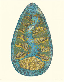
Print, HAMM, Treahna b. 1965, Melbourne, Paradise Overkill, 1995
... ...connection to land...Latrobe Regional Gallery 138 Commercial Road Morwell gippsland etching land spiritual environment connection to land disruption Edition 26/50 in lower left corner. ...Hand coloured etching Edition 26/50 in lower left corner. Titled 'Paradise Overkill' on bottom centre. Signed and dated 'Treahna Hamm '95' lower right corner.etching, land, spiritual, environment, connection to land, disruption -
 Victorian Aboriginal Corporation for Languages
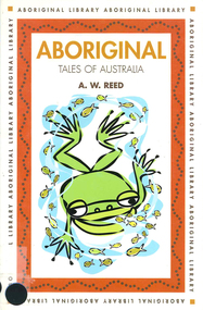
Book, A W Reed, Aboriginal tales of Australia, 1998
... Populated by mythical beings, these stories of heros, birds, rivers, lakes and shores have been passed down over generations and today offer a window of understanding into the powerful Aboriginal connection to the land....Victorian Aboriginal Corporation for Languages 33 Saxon Street Brunswick melbourne creation stories Dreamtime word lists Populated by mythical beings, these stories of heros, birds, rivers, lakes and shores have been passed down over generations and today offer a window of understanding into the powerful Aboriginal connection to the land. Aboriginal tales of Australia Book A W Reed ...Populated by mythical beings, these stories of heros, birds, rivers, lakes and shores have been passed down over generations and today offer a window of understanding into the powerful Aboriginal connection to the land.word listscreation stories, dreamtime -
 Sunshine and District Historical Society Incorporated
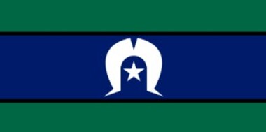
Flag - Torres Strait Islander Flag
... It represents their deep connection to land, sea, sky, and community, and has been an official Flag of Australia since 1995. ...It represents their deep connection to land, sea, sky, and community, and has been an official Flag of Australia since 1995. ...The Torres Strait Islander Flag is a symbol of unity, identity, and cultural strength for Torres Strait Islander peoples. It represents their deep connection to land, sea, sky, and community, and has been an official Flag of Australia since 1995. The colour green on the flag (top & bottom) represents the land of the Torres Strait Islands and surrounding regions, blue (centre) represents the sea, central to Torres Strait life, culture, and navigation, and the black lines represent the Torres Strait Islander people themselves. The central symbols, the white Dhari (headdress) is a powerful emblem of Torres Strait Islander culture, ceremony, and identity and the white five‑pointed star symbolises navigation, peace, and the five major island groups of the Torres Strait.The flag was designed in 1992 and first presented at the Torres Strait Cultural Festival on 29 May 1992. It was recognised by the Aboriginal and Torres Strait Islander Commission shortly after. It was officially proclaimed a Flag of Australia on 14 July 1995 under the Flags Act 1953. Torres Strait Islander Flag. This flag is suitable to be flown on a flagpole.Manufacturer's Tag: Manufactured in Australia by Carroll & Richardsonfirst nations, torres strait islander flag, torres strait islander -
 The Beechworth Burke Museum
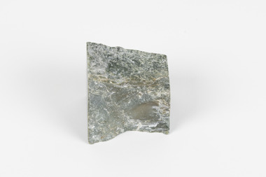
Geological specimen - Greenstone, Hokitika Jade Company, unknown
... Wearing of Greenstone pendants with different carvings is practiced by Maori to represent connection to land and ancestors, or to endow the wearer with certain attributes. ...Wearing of Greenstone pendants with different carvings is practiced by Maori to represent connection to land and ancestors, or to endow the wearer with certain attributes. ...New Zealand Greenstone, also called Pounamu is found on New Zealand’s South Island in riverbeds and boulders, and colours vary depending on the source, but always include green tones. It is a form of the mineral nephrite, also known as jade, and is a tough stone with a crystalline structure, made up of calcium magnesium and iron silicate. Its hardness means it is ideal for carving, and has been used for this purpose throughout history, especially by the Maori people of New Zealand. Greenstone features heavily in Maori mythology, and the traditional name for the South Island, Te-Wai-Pounamu, literally translates to waters of greenstone. Wearing of Greenstone pendants with different carvings is practiced by Maori to represent connection to land and ancestors, or to endow the wearer with certain attributes. The sticker on the base of the specimen identifies it as a product of Hokitika Jade Company. The company, which was active in the 1970s, sold jade and greenstone specimens and ornaments. Hokitika, which started life as an 1860s gold rush town, is the origin of most nephrite found in New Zealand, and the centre of the Greenstone carving industry. The object has scientific and research potential as part of the Burke Museum's Geology Collection, and as and example of New Zealand Greenstone. It also has spiritual significance for it's role in Maori beliefs and communities, where it is both traditionally worn and features in mythology. As a valuable stone regularly used in carving and jewellery, it has aesthetic significance. Sticker on base: "N.Z. Greenstone/ a product of/ Hokitika Jade Coy."geological specimen, geology, geology collection, burke museum, beechworth, new zealand, greenstone, hokitika, nephrite, jade -
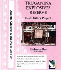 Truganina Explosives Reserve Preservation Society Inc (TERPS)
Digitised Oral History – Truganina Explosives Reserve - Tape 8 Annette Xibarras and Bill Nicholson Jnr, 2018
... They discussed their childhood, aboriginal customs, connection with the land and the locating of aboriginal remains at the Museum of Victoria and the re-burial at the site where they were found. ...They discussed their childhood, aboriginal customs, connection with the land and the locating of aboriginal remains at the Museum of Victoria and the re-burial at the site where they were found. ...The interviews were recorded in 2000 by Bronwen Gray and Alan Young for the production of Unreserved, Stories from Truganina Explosives Reserve, animated stories from past residents, workers and interested people of the Reserve (subject to copyright 2004). Annette Xibarras and Bill Nicholson Jnr discuss the indigenous significance of the Truganina Explosives Reserve. At the time of the interview Annette was the manager of the Kulin Nations Cultural Heritage Organisation. Bill, a Wurundjeri Elder, was a Wurundjeri Cultural Officer. They discussed their childhood, aboriginal customs, connection with the land and the locating of aboriginal remains at the Museum of Victoria and the re-burial at the site where they were found. A primary source of information on memories of the Truganina Explosives Reserve and Altona,VictoriaDigital copy of original cassette recorded in 2000 and digitised in 2018julia jones, princess balam balam, archaeological survey, middens, wurundjeri, kulin nations, coranderrk, braybrook, sacred sites, mt william, bunurong, museum victoria, altona, martha nicholson -
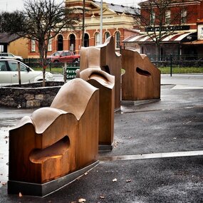 City of Ballarat
Artwork, other - Public Artwork, Cliff Burtt, Buninyong Bivium, 2016
... Traditional land of the Wadawurrung people, today the area remains a significant site for the culture of indigenous people and their connection to the land. ...Traditional land of the Wadawurrung people, today the area remains a significant site for the culture of indigenous people and their connection to the land. ...Buninyong Bivium (2016) by Cliff Burtt engages with the geography and history of the Buninyong region in both pre and post settlement. The town of Buninyong is dominated by the profiles of Mt Helen and the extinct volcano Mt. Buninyong. Traditional land of the Wadawurrung people, today the area remains a significant site for the culture of indigenous people and their connection to the land. The profile of this sculpture is based on topographical mapping of the area, depicting sections of the landscape. The gaps between the elements of the work can be viewed as representations of the shafts sunk into the earth by the early gold miners and compound curves on the upper surfaces are mirroring the topography of the area, while cut-aways in the sides are suggestive of rock strata.The artwork is of aesthetic and social significance to the people of BallaratCorten steel sculpture made of five unique sculptural pieces secured to at concreate base at pavement levelbuninyong, cliff burtt, sculpture, public art, mining, ballarat -
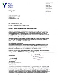 Wonga Park Community Cottage History Group
Letter - dated 20 August 2013 from Yarra Valley Water to Ashdale Crest Pty Ltd, advising that sewerage is now available for connection to 6 Launders Avenue Wonga Park
... Letter annotated with handwritten note 2/9/2013 Advised connection not required as vacant land...Letter annotated with handwritten note 2/9/2013 Advised connection not required as vacant land On the first page it is inscribed with the name "Robyn Smiley" and the school "Wonga Park" advising that sewerage is now available for connection to 6 Launders Avenue Wonga Park. ...Letter dated 20 August 2013 from Yarra Valley Water to Ashdale Crest Pty Ltd advising that sewerage is now available for connection to 6 Launders Avenue Wonga Park. Letter annotated with handwritten note 2/9/2013 Advised connection not required as vacant landOn the first page it is inscribed with the name "Robyn Smiley" and the school "Wonga Park" -
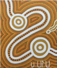 Federation University Art Collection
Painting - Artwork - Painting, Bonnie Fagan (Chew), 2013
... Bonnie Fagan wrote of this work: "Ochres reflect my connection with the land of my traditional Wadawurrung Country. ...Bonnie Fagan wrote of this work: "Ochres reflect my connection with the land of my traditional Wadawurrung Country. ...Bonnie Fagan's County is Wadawurrung. Most of her early learning about her Aboriginality came from the father.Aboriginal dot painting telling the artist's learning journey. Bonnie Fagan wrote of this work: "Ochres reflect my connection with the land of my traditional Wadawurrung Country. Yellow ochre forms the background and white ochre defines my pathway, showing where I have traveled from my past and where I am heading in my future. I use reddish ochres for the larger dots along my pathway to show my footprint and for the smaller dots that ripple outwards to show how I've had some influence, either good or bad. The white lines show my pathway with an entry point from my past marking the start of my journey, a middle part showing were my life will continue. Through the middle part, my teenage years, the pathway is very windy. These years were sometime quite difficult and I struggled. The two circle areas symbolize two chapters in my life, first as a child and then as an adult, when I've felt mostly positive and safe. They are periods when I've been very open to learning, gathering knowledge from people and experiences that I trusted, and the circles within the circles symbolize the layers of support, of experience, of connection and of learning that I experienced. Strong visual symbols at the base of the painting under the first circle area represent the key figures in my learning through my childhood: my father (represented by the traditional symbol, of a man with a spear) and my mothers with me as a small child, The spirit of my paternal grandmother, my Nan, hovers above my childhood circle and near the pathway through to my teenage years, showing the strength of her influence and how she was always there guiding me." (Robyn Brandenburg and Jacqueline Z, Wilson [Eds] Pedagogies for the Future: Leading Quality Learning and Teaching in Higher Education, Sense Publishers, The Netherlands, 2013, pp40-41)bonnie fagan, bonnie chew, wadawurrung, artists, artwork, aboriginal -
 Eltham District Historical Society Inc
Document - Property Binder, 1184 Main Road, Eltham
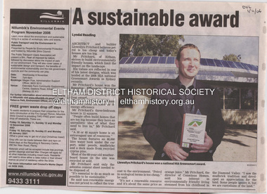
... Pritchard believes the sustainable way indigenous Australians lived and their spiritual connection with land, demonstrates how humanity is part of the ecology. ...Pritchard believes the sustainable way indigenous Australians lived and their spiritual connection with land, demonstrates how humanity is part of the ecology. ...Newspaper article: A sustainable award, Diamond Valley Leader, 1 November2006, Architect and building Llewellyn Pritchard won resource Efficiency Housing Award, finalist in HIA Greensmart Building of the Year Award. House – Environmental Leader (Published: Nillumbik Now and Then / Marguerite Marshall 2008; photographs Alan King with Marguerite Marshall.; p186) In 2006 environmental awareness was mushrooming in the community, which is reflected in the award-winning house at Main Road near Wattletree Road, Eltham. At first sight, the building appears a mix of a classic Eltham mud-brick house and an avant-garde building style. The crown of solar panels stretching along the width of the curved roof, indicates that this is no ordinary house. In fact it signals a new building trend of minimal impact on the environment. Yet it utilises the environment with high technical expertise to achieve comfort and cut running and maintenance costs. In recognition of this, its designer/builder, Conscious Homes, won the 2006 National HIA Greensmart Resource Efficiency Award. For Conscious Homes director, Llewellyn Pritchard, this house reflects a philosophy, strengthened by his connection with Aboriginal culture, through his foster siblings. Pritchard believes the sustainable way indigenous Australians lived and their spiritual connection with land, demonstrates how humanity is part of the ecology. His interest in environmental design stemmed from growing up in bushy Eltham Shire, with its mud-brick tradition. This was followed by studying Architecture at RMIT in the early 1980s, and learning about passive solar design. Pritchard says this house demonstrates that environmental sustainability is not about sacrifice, but about exceptional levels of occupant comfort, savings in running costs and modern fittings and appliances.1 The solar panels on the north roofs are intentionally obvious to make a statement about what the building is doing. But inside the systems are hidden and interactive with conventional services, such as the underground water tank. The house is water and energy self-sufficient and at 12 squares is much smaller than conventional houses, to minimise resources. Yet it accommodates his family of four with three bedrooms, a living/dining and kitchen area and a bathroom/laundry. Importantly the building is designed to last hundreds of years, by being able to be modified as the need arises, such as for commercial use. In this way the structure minimises its environmental impact. The solid double mud-brick walls (which are insulated) include steel beams and supporting frame, allowing the future removal or alteration of any section. The materials are local, recycled and of low toxicity where possible.2 Inside and out, the mud-brick is rendered and sealed with a combination of cement and sand and a mud-based coating in a soft golden hue increases its life. Inside, the golden-brown timber is plantation Mountain Ash and the concrete floors throughout – of local stone aggregate with a clear seal – have a natural looking random stone appearance. The house sustains a stable temperature of around 20 degrees, assisted by the concrete slab floor. The many large double-glazed windows and highlights (windows set high on walls) provide cross-flow ventilation. The north-facing living area maximises heating from the lower winter sun and is cooler in summer, because the sun is higher. Heating comes from a solar hydronic slab system. All appliances and fittings are high efficiency energy or water rated. Appliances in the timber kitchen include a gas stove and a dishwasher, using the building’s own power and water. French doors open from the living area to a deck, concealing the treatment system for all waste water. This is pumped through sub-soil drippers to the indigenous garden beds and no-dig vegetable patch. Below the carport is the 80,000-litre rainwater tank and at the back, the boiler room houses the solar boiler, water tank access, domestic water supply pump, filter gear and hydronic slab heating controls. The solar system is backed up with gas, which is needed to heat water only in winter. Gas used is less than one quarter of that for an average home with ducted heating. Excess power is fed back to the grid and the building uses about one quarter of the mains electricity of an average home. Other local builders have followed Pritchard’s lead in resource efficiency for minimal environmental impact.main road, eltham, businesses, llewellyn pritchard, hia greensmart building of the year award., efficiency housing award, conscious homes australia pty ltd -
 Eltham District Historical Society Inc
Photograph - Black and White Print, Shire of Eltham, Meruka Child Care Centre, turning the first sod: Cr Pamela Sladden, Peter Staples MHR Jaga Jaga, c.1993
... land fronting Meruka Drive. The property then passed from the Charleston family to Gerald and Margaret Sutton in 1976 and again was sold in 1980 and lastly sold again in 1994. The Norths named their house 'Tralford'. According to Marjorie North, the name Meruka was suggested by Alan Gardner and so was apparently not used by the North family. The name appears to be of Indian origin and its connection...land fronting Meruka Drive. The property then passed from the Charleston family to Gerald and Margaret Sutton in 1976 and again was sold in 1980 and lastly sold again in 1994. The Norths named their house 'Tralford'. According to Marjorie North, the name Meruka was suggested by Alan Gardner and so was apparently not used by the North family. The name appears to be of Indian origin and its connection ...In 1919 J.B. North, a violinist with the then Melbourne Symphonic Orchestra, and Monsieur Leon Lambert, a French architect, who later designed the Glaciarium Ice Skating Rink, purchased three available farms, Looker's, Wright's and Taylor's, approximately 60 acres, the area running along the creek and being bordered by the present day Ryans Road, Karingal Drive and Sherbourne Road. The farms were used for orchards and market gardens. Leon Lambert designed and built two homes on the farm site, one for the North family, ‘Tralford’, and the other, ‘Glen Ellen’, for himself and his wife. The homes were considered as "brother and sister" and they each included in their design an identical bay window in the main living area. "Glen Ellen" originally comprised kitchen, lounge room, inglenook, dining room, bath room and sleepout. Although the home has been extended over the years, much of the original architecture has been retained including timber panelling and three fireplaces. The land was subdivided in approximately 1966 with "Glen Ellen" retaining approximately one half acre of land fronting Meruka Drive. The property then passed from the Charleston family to Gerald and Margaret Sutton in 1976 and again was sold in 1980 and lastly sold again in 1994. The Norths named their house 'Tralford'. According to Marjorie North, the name Meruka was suggested by Alan Gardner and so was apparently not used by the North family. The name appears to be of Indian origin and its connection with the land is not known. ‘Tralford’ stayed in the North family for many years. Eltham Council acquired the house to create Meruka Park. The house was used for some years by the Council as a community arts facility and as emergency accommodation. It fell into disrepair and was demolished about 1990. The Meruka Child Care Centre has been built on the site and incorporates some of the architectural features of the old house. The Co-op was opened in April 1994. The original drive flanked by large old cypress trees remains. These trees are considered to be of local heritage significance and for this reason Meruka Park is covered by a Heritage Overlay under the Nillumbik Planning Scheme. Part of the park has been preserved as habitat for rare local flora. LL's house, named ‘Glen Ellen’, remains in a well-preserved state and fronts Meruka Drive.shire of eltham archives, child care centres, health & community services, meruka child care co-operative, peter staples mhr jaga jaga, cr pamela sladden -
 Eltham District Historical Society Inc
Photograph - Black and White Print, Shire of Eltham, Meruka Child Care Centre, Eltham, c.1994
... land fronting Meruka Drive. The property then passed from the Charleston family to Gerald and Margaret Sutton in 1976 and again was sold in 1980 and lastly sold again in 1994. The Norths named their house 'Tralford'. According to Marjorie North, the name Meruka was suggested by Alan Gardner and so was apparently not used by the North family. The name appears to be of Indian origin and its connection...land fronting Meruka Drive. The property then passed from the Charleston family to Gerald and Margaret Sutton in 1976 and again was sold in 1980 and lastly sold again in 1994. The Norths named their house 'Tralford'. According to Marjorie North, the name Meruka was suggested by Alan Gardner and so was apparently not used by the North family. The name appears to be of Indian origin and its connection ...In 1919 J.B. North, a violinist with the then Melbourne Symphonic Orchestra, and Monsieur Leon Lambert, a French architect, who later designed the Glaciarium Ice Skating Rink, purchased three available farms, Looker's, Wright's and Taylor's, approximately 60 acres, the area running along the creek and being bordered by the present day Ryans Road, Karingal Drive and Sherbourne Road. The farms were used for orchards and market gardens. Leon Lambert designed and built two homes on the farm site, one for the North family, ‘Tralford’, and the other, ‘Glen Ellen’, for himself and his wife. The homes were considered as "brother and sister" and they each included in their design an identical bay window in the main living area. "Glen Ellen" originally comprised kitchen, lounge room, inglenook, dining room, bath room and sleepout. Although the home has been extended over the years, much of the original architecture has been retained including timber panelling and three fireplaces. The land was subdivided in approximately 1966 with "Glen Ellen" retaining approximately one half acre of land fronting Meruka Drive. The property then passed from the Charleston family to Gerald and Margaret Sutton in 1976 and again was sold in 1980 and lastly sold again in 1994. The Norths named their house 'Tralford'. According to Marjorie North, the name Meruka was suggested by Alan Gardner and so was apparently not used by the North family. The name appears to be of Indian origin and its connection with the land is not known. ‘Tralford’ stayed in the North family for many years. Eltham Council acquired the house to create Meruka Park. The house was used for some years by the Council as a community arts facility and as emergency accommodation. It fell into disrepair and was demolished about 1990. The Meruka Child Care Centre has been built on the site and incorporates some of the architectural features of the old house. The Co-op was opened in April 1994. The original drive flanked by large old cypress trees remains. These trees are considered to be of local heritage significance and for this reason Meruka Park is covered by a Heritage Overlay under the Nillumbik Planning Scheme. Part of the park has been preserved as habitat for rare local flora. LL's house, named ‘Glen Ellen’, remains in a well-preserved state and fronts Meruka Drive.shire of eltham archives, child care centres, health & community services, meruka child care co-operative -
 Eltham District Historical Society Inc
Opening of Meruka Childcare Co-operative, Meruka Park, 5 Meruka Dr, Eltham, April 1994
... land fronting Meruka Drive. The property then passed from the Charleston family to Gerald and Margaret Sutton in 1976 and again was sold in 1980 and lastly sold again in 1994. The Norths named their house 'Tralford'. According to Marjorie North, the name Meruka was suggested by Alan Gardner and so was apparently not used by the North family. The name appears to be of Indian origin and its connection...land fronting Meruka Drive. The property then passed from the Charleston family to Gerald and Margaret Sutton in 1976 and again was sold in 1980 and lastly sold again in 1994. The Norths named their house 'Tralford'. According to Marjorie North, the name Meruka was suggested by Alan Gardner and so was apparently not used by the North family. The name appears to be of Indian origin and its connection ...In 1919 J.B. North, a violinist with the then Melbourne Symphonic Orchestra, and Monsieur Leon Lambert, a French architect, who later designed the Glaciarium Ice Skating Rink, purchased three available farms, Looker's, Wright's and Taylor's, approximately 60 acres, the area running along the creek and being bordered by the present day Ryans Road, Karingal Drive and Sherbourne Road. The farms were used for orchards and market gardens. Leon Lambert designed and built two homes on the farm site, one for the North family, ‘Tralford’, and the other, ‘Glen Ellen’, for himself and his wife. The homes were considered as "brother and sister" and they each included in their design an identical bay window in the main living area. "Glen Ellen" originally comprised kitchen, lounge room, inglenook, dining room, bath room and sleepout. Although the home has been extended over the years, much of the original architecture has been retained including timber panelling and three fireplaces. The land was subdivided in approximately 1966 with "Glen Ellen" retaining approximately one half acre of land fronting Meruka Drive. The property then passed from the Charleston family to Gerald and Margaret Sutton in 1976 and again was sold in 1980 and lastly sold again in 1994. The Norths named their house 'Tralford'. According to Marjorie North, the name Meruka was suggested by Alan Gardner and so was apparently not used by the North family. The name appears to be of Indian origin and its connection with the land is not known. ‘Tralford’ stayed in the North family for many years. Eltham Council acquired the house to create Meruka Park. The house was used for some years by the Council as a community arts facility and as emergency accommodation. It fell into disrepair and was demolished about 1990. The Meruka Child Care Centre has been built on the site and incorporates some of the architectural features of the old house. The Co-op was opened in April 1994. The original drive flanked by large old cypress trees remains. These trees are considered to be of local heritage significance and for this reason Meruka Park is covered by a Heritage Overlay under the Nillumbik Planning Scheme. Part of the park has been preserved as habitat for rare local flora. LL's house, named ‘Glen Ellen’, remains in a well-preserved state and fronts Meruka Drive.cr pam sladden, eltham, meruka child care co-operative, meruka house, meruka park -
 Eltham District Historical Society Inc
Opening of Meruka Childcare Co-operative, Meruka Park, 5 Meruka Dr, Eltham, April 1994
... land fronting Meruka Drive. The property then passed from the Charleston family to Gerald and Margaret Sutton in 1976 and again was sold in 1980 and lastly sold again in 1994. The Norths named their house 'Tralford'. According to Marjorie North, the name Meruka was suggested by Alan Gardner and so was apparently not used by the North family. The name appears to be of Indian origin and its connection...land fronting Meruka Drive. The property then passed from the Charleston family to Gerald and Margaret Sutton in 1976 and again was sold in 1980 and lastly sold again in 1994. The Norths named their house 'Tralford'. According to Marjorie North, the name Meruka was suggested by Alan Gardner and so was apparently not used by the North family. The name appears to be of Indian origin and its connection ...In 1919 J.B. North, a violinist with the then Melbourne Symphonic Orchestra, and Monsieur Leon Lambert, a French architect, who later designed the Glaciarium Ice Skating Rink, purchased three available farms, Looker's, Wright's and Taylor's, approximately 60 acres, the area running along the creek and being bordered by the present day Ryans Road, Karingal Drive and Sherbourne Road. The farms were used for orchards and market gardens. Leon Lambert designed and built two homes on the farm site, one for the North family, ‘Tralford’, and the other, ‘Glen Ellen’, for himself and his wife. The homes were considered as "brother and sister" and they each included in their design an identical bay window in the main living area. "Glen Ellen" originally comprised kitchen, lounge room, inglenook, dining room, bath room and sleepout. Although the home has been extended over the years, much of the original architecture has been retained including timber panelling and three fireplaces. The land was subdivided in approximately 1966 with "Glen Ellen" retaining approximately one half acre of land fronting Meruka Drive. The property then passed from the Charleston family to Gerald and Margaret Sutton in 1976 and again was sold in 1980 and lastly sold again in 1994. The Norths named their house 'Tralford'. According to Marjorie North, the name Meruka was suggested by Alan Gardner and so was apparently not used by the North family. The name appears to be of Indian origin and its connection with the land is not known. ‘Tralford’ stayed in the North family for many years. Eltham Council acquired the house to create Meruka Park. The house was used for some years by the Council as a community arts facility and as emergency accommodation. It fell into disrepair and was demolished about 1990. The Meruka Child Care Centre has been built on the site and incorporates some of the architectural features of the old house. The Co-op was opened in April 1994. The original drive flanked by large old cypress trees remains. These trees are considered to be of local heritage significance and for this reason Meruka Park is covered by a Heritage Overlay under the Nillumbik Planning Scheme. Part of the park has been preserved as habitat for rare local flora. LL's house, named ‘Glen Ellen’, remains in a well-preserved state and fronts Meruka Drive.eltham, meruka child care co-operative, meruka house, meruka park, cr. peter graham, peter staples, richard allen, sheryl garbutt, bill penrose -
 Eltham District Historical Society Inc
Opening of Meruka Childcare Co-operative, Meruka Park, 5 Meruka Dr, Eltham, April 1994
... land fronting Meruka Drive. The property then passed from the Charleston family to Gerald and Margaret Sutton in 1976 and again was sold in 1980 and lastly sold again in 1994. The Norths named their house 'Tralford'. According to Marjorie North, the name Meruka was suggested by Alan Gardner and so was apparently not used by the North family. The name appears to be of Indian origin and its connection...land fronting Meruka Drive. The property then passed from the Charleston family to Gerald and Margaret Sutton in 1976 and again was sold in 1980 and lastly sold again in 1994. The Norths named their house 'Tralford'. According to Marjorie North, the name Meruka was suggested by Alan Gardner and so was apparently not used by the North family. The name appears to be of Indian origin and its connection ...In 1919 J.B. North, a violinist with the then Melbourne Symphonic Orchestra, and Monsieur Leon Lambert, a French architect, who later designed the Glaciarium Ice Skating Rink, purchased three available farms, Looker's, Wright's and Taylor's, approximately 60 acres, the area running along the creek and being bordered by the present day Ryans Road, Karingal Drive and Sherbourne Road. The farms were used for orchards and market gardens. Leon Lambert designed and built two homes on the farm site, one for the North family, ‘Tralford’, and the other, ‘Glen Ellen’, for himself and his wife. The homes were considered as "brother and sister" and they each included in their design an identical bay window in the main living area. "Glen Ellen" originally comprised kitchen, lounge room, inglenook, dining room, bath room and sleepout. Although the home has been extended over the years, much of the original architecture has been retained including timber panelling and three fireplaces. The land was subdivided in approximately 1966 with "Glen Ellen" retaining approximately one half acre of land fronting Meruka Drive. The property then passed from the Charleston family to Gerald and Margaret Sutton in 1976 and again was sold in 1980 and lastly sold again in 1994. The Norths named their house 'Tralford'. According to Marjorie North, the name Meruka was suggested by Alan Gardner and so was apparently not used by the North family. The name appears to be of Indian origin and its connection with the land is not known. ‘Tralford’ stayed in the North family for many years. Eltham Council acquired the house to create Meruka Park. The house was used for some years by the Council as a community arts facility and as emergency accommodation. It fell into disrepair and was demolished about 1990. The Meruka Child Care Centre has been built on the site and incorporates some of the architectural features of the old house. The Co-op was opened in April 1994. The original drive flanked by large old cypress trees remains. These trees are considered to be of local heritage significance and for this reason Meruka Park is covered by a Heritage Overlay under the Nillumbik Planning Scheme. Part of the park has been preserved as habitat for rare local flora. LL's house, named ‘Glen Ellen’, remains in a well-preserved state and fronts Meruka Drive.eltham, meruka child care co-operative, meruka house, meruka park, cr. john cohen -
 Eltham District Historical Society Inc
Opening of Meruka Childcare Co-operative, Meruka Park, 5 Meruka Dr, Eltham, April 1994
... land fronting Meruka Drive. The property then passed from the Charleston family to Gerald and Margaret Sutton in 1976 and again was sold in 1980 and lastly sold again in 1994. The Norths named their house 'Tralford'. According to Marjorie North, the name Meruka was suggested by Alan Gardner and so was apparently not used by the North family. The name appears to be of Indian origin and its connection...land fronting Meruka Drive. The property then passed from the Charleston family to Gerald and Margaret Sutton in 1976 and again was sold in 1980 and lastly sold again in 1994. The Norths named their house 'Tralford'. According to Marjorie North, the name Meruka was suggested by Alan Gardner and so was apparently not used by the North family. The name appears to be of Indian origin and its connection ...In 1919 J.B. North, a violinist with the then Melbourne Symphonic Orchestra, and Monsieur Leon Lambert, a French architect, who later designed the Glaciarium Ice Skating Rink, purchased three available farms, Looker's, Wright's and Taylor's, approximately 60 acres, the area running along the creek and being bordered by the present day Ryans Road, Karingal Drive and Sherbourne Road. The farms were used for orchards and market gardens. Leon Lambert designed and built two homes on the farm site, one for the North family, ‘Tralford’, and the other, ‘Glen Ellen’, for himself and his wife. The homes were considered as "brother and sister" and they each included in their design an identical bay window in the main living area. "Glen Ellen" originally comprised kitchen, lounge room, inglenook, dining room, bath room and sleepout. Although the home has been extended over the years, much of the original architecture has been retained including timber panelling and three fireplaces. The land was subdivided in approximately 1966 with "Glen Ellen" retaining approximately one half acre of land fronting Meruka Drive. The property then passed from the Charleston family to Gerald and Margaret Sutton in 1976 and again was sold in 1980 and lastly sold again in 1994. The Norths named their house 'Tralford'. According to Marjorie North, the name Meruka was suggested by Alan Gardner and so was apparently not used by the North family. The name appears to be of Indian origin and its connection with the land is not known. ‘Tralford’ stayed in the North family for many years. Eltham Council acquired the house to create Meruka Park. The house was used for some years by the Council as a community arts facility and as emergency accommodation. It fell into disrepair and was demolished about 1990. The Meruka Child Care Centre has been built on the site and incorporates some of the architectural features of the old house. The Co-op was opened in April 1994. The original drive flanked by large old cypress trees remains. These trees are considered to be of local heritage significance and for this reason Meruka Park is covered by a Heritage Overlay under the Nillumbik Planning Scheme. Part of the park has been preserved as habitat for rare local flora. LL's house, named ‘Glen Ellen’, remains in a well-preserved state and fronts Meruka Drive.eltham, meruka child care co-operative, meruka house, meruka park, rob hauser -
 Eltham District Historical Society Inc
Opening of Meruka Childcare Co-operative, Meruka Park, 5 Meruka Dr, Eltham, April 1994
... land fronting Meruka Drive. The property then passed from the Charleston family to Gerald and Margaret Sutton in 1976 and again was sold in 1980 and lastly sold again in 1994. The Norths named their house 'Tralford'. According to Marjorie North, the name Meruka was suggested by Alan Gardner and so was apparently not used by the North family. The name appears to be of Indian origin and its connection...land fronting Meruka Drive. The property then passed from the Charleston family to Gerald and Margaret Sutton in 1976 and again was sold in 1980 and lastly sold again in 1994. The Norths named their house 'Tralford'. According to Marjorie North, the name Meruka was suggested by Alan Gardner and so was apparently not used by the North family. The name appears to be of Indian origin and its connection ...In 1919 J.B. North, a violinist with the then Melbourne Symphonic Orchestra, and Monsieur Leon Lambert, a French architect, who later designed the Glaciarium Ice Skating Rink, purchased three available farms, Looker's, Wright's and Taylor's, approximately 60 acres, the area running along the creek and being bordered by the present day Ryans Road, Karingal Drive and Sherbourne Road. The farms were used for orchards and market gardens. Leon Lambert designed and built two homes on the farm site, one for the North family, ‘Tralford’, and the other, ‘Glen Ellen’, for himself and his wife. The homes were considered as "brother and sister" and they each included in their design an identical bay window in the main living area. "Glen Ellen" originally comprised kitchen, lounge room, inglenook, dining room, bath room and sleepout. Although the home has been extended over the years, much of the original architecture has been retained including timber panelling and three fireplaces. The land was subdivided in approximately 1966 with "Glen Ellen" retaining approximately one half acre of land fronting Meruka Drive. The property then passed from the Charleston family to Gerald and Margaret Sutton in 1976 and again was sold in 1980 and lastly sold again in 1994. The Norths named their house 'Tralford'. According to Marjorie North, the name Meruka was suggested by Alan Gardner and so was apparently not used by the North family. The name appears to be of Indian origin and its connection with the land is not known. ‘Tralford’ stayed in the North family for many years. Eltham Council acquired the house to create Meruka Park. The house was used for some years by the Council as a community arts facility and as emergency accommodation. It fell into disrepair and was demolished about 1990. The Meruka Child Care Centre has been built on the site and incorporates some of the architectural features of the old house. The Co-op was opened in April 1994. The original drive flanked by large old cypress trees remains. These trees are considered to be of local heritage significance and for this reason Meruka Park is covered by a Heritage Overlay under the Nillumbik Planning Scheme. Part of the park has been preserved as habitat for rare local flora. LL's house, named ‘Glen Ellen’, remains in a well-preserved state and fronts Meruka Drive.eltham, meruka child care co-operative, meruka house, meruka park, irene bogle -
 Eltham District Historical Society Inc
Opening of Meruka Childcare Co-operative, Meruka Park, 5 Meruka Dr, Eltham, April 1994
... land fronting Meruka Drive. The property then passed from the Charleston family to Gerald and Margaret Sutton in 1976 and again was sold in 1980 and lastly sold again in 1994. The Norths named their house 'Tralford'. According to Marjorie North, the name Meruka was suggested by Alan Gardner and so was apparently not used by the North family. The name appears to be of Indian origin and its connection...land fronting Meruka Drive. The property then passed from the Charleston family to Gerald and Margaret Sutton in 1976 and again was sold in 1980 and lastly sold again in 1994. The Norths named their house 'Tralford'. According to Marjorie North, the name Meruka was suggested by Alan Gardner and so was apparently not used by the North family. The name appears to be of Indian origin and its connection ...In 1919 J.B. North, a violinist with the then Melbourne Symphonic Orchestra, and Monsieur Leon Lambert, a French architect, who later designed the Glaciarium Ice Skating Rink, purchased three available farms, Looker's, Wright's and Taylor's, approximately 60 acres, the area running along the creek and being bordered by the present day Ryans Road, Karingal Drive and Sherbourne Road. The farms were used for orchards and market gardens. Leon Lambert designed and built two homes on the farm site, one for the North family, ‘Tralford’, and the other, ‘Glen Ellen’, for himself and his wife. The homes were considered as "brother and sister" and they each included in their design an identical bay window in the main living area. "Glen Ellen" originally comprised kitchen, lounge room, inglenook, dining room, bath room and sleepout. Although the home has been extended over the years, much of the original architecture has been retained including timber panelling and three fireplaces. The land was subdivided in approximately 1966 with "Glen Ellen" retaining approximately one half acre of land fronting Meruka Drive. The property then passed from the Charleston family to Gerald and Margaret Sutton in 1976 and again was sold in 1980 and lastly sold again in 1994. The Norths named their house 'Tralford'. According to Marjorie North, the name Meruka was suggested by Alan Gardner and so was apparently not used by the North family. The name appears to be of Indian origin and its connection with the land is not known. ‘Tralford’ stayed in the North family for many years. Eltham Council acquired the house to create Meruka Park. The house was used for some years by the Council as a community arts facility and as emergency accommodation. It fell into disrepair and was demolished about 1990. The Meruka Child Care Centre has been built on the site and incorporates some of the architectural features of the old house. The Co-op was opened in April 1994. The original drive flanked by large old cypress trees remains. These trees are considered to be of local heritage significance and for this reason Meruka Park is covered by a Heritage Overlay under the Nillumbik Planning Scheme. Part of the park has been preserved as habitat for rare local flora. LL's house, named ‘Glen Ellen’, remains in a well-preserved state and fronts Meruka Drive.eltham, meruka child care co-operative, meruka house, meruka park, cr bob manuell, matthew rodscholler -
 Eltham District Historical Society Inc
Opening of Meruka Childcare Co-operative, Meruka Park, 5 Meruka Dr, Eltham, April 1994
... land fronting Meruka Drive. The property then passed from the Charleston family to Gerald and Margaret Sutton in 1976 and again was sold in 1980 and lastly sold again in 1994. The Norths named their house 'Tralford'. According to Marjorie North, the name Meruka was suggested by Alan Gardner and so was apparently not used by the North family. The name appears to be of Indian origin and its connection...land fronting Meruka Drive. The property then passed from the Charleston family to Gerald and Margaret Sutton in 1976 and again was sold in 1980 and lastly sold again in 1994. The Norths named their house 'Tralford'. According to Marjorie North, the name Meruka was suggested by Alan Gardner and so was apparently not used by the North family. The name appears to be of Indian origin and its connection ...In 1919 J.B. North, a violinist with the then Melbourne Symphonic Orchestra, and Monsieur Leon Lambert, a French architect, who later designed the Glaciarium Ice Skating Rink, purchased three available farms, Looker's, Wright's and Taylor's, approximately 60 acres, the area running along the creek and being bordered by the present day Ryans Road, Karingal Drive and Sherbourne Road. The farms were used for orchards and market gardens. Leon Lambert designed and built two homes on the farm site, one for the North family, ‘Tralford’, and the other, ‘Glen Ellen’, for himself and his wife. The homes were considered as "brother and sister" and they each included in their design an identical bay window in the main living area. "Glen Ellen" originally comprised kitchen, lounge room, inglenook, dining room, bath room and sleepout. Although the home has been extended over the years, much of the original architecture has been retained including timber panelling and three fireplaces. The land was subdivided in approximately 1966 with "Glen Ellen" retaining approximately one half acre of land fronting Meruka Drive. The property then passed from the Charleston family to Gerald and Margaret Sutton in 1976 and again was sold in 1980 and lastly sold again in 1994. The Norths named their house 'Tralford'. According to Marjorie North, the name Meruka was suggested by Alan Gardner and so was apparently not used by the North family. The name appears to be of Indian origin and its connection with the land is not known. ‘Tralford’ stayed in the North family for many years. Eltham Council acquired the house to create Meruka Park. The house was used for some years by the Council as a community arts facility and as emergency accommodation. It fell into disrepair and was demolished about 1990. The Meruka Child Care Centre has been built on the site and incorporates some of the architectural features of the old house. The Co-op was opened in April 1994. The original drive flanked by large old cypress trees remains. These trees are considered to be of local heritage significance and for this reason Meruka Park is covered by a Heritage Overlay under the Nillumbik Planning Scheme. Part of the park has been preserved as habitat for rare local flora. LL's house, named ‘Glen Ellen’, remains in a well-preserved state and fronts Meruka Drive.eltham, meruka child care co-operative, meruka house, meruka park, cr pam sladden, mandy press -
 Sunshine and District Historical Society Incorporated
Archive - Aboriginal First Nation and Archaelogy
... Newspaper Article Brimbank Independent 6 May 1997 Aboriginal reconciliation meeting at St Albans|Typed Letter 8 June 1982 Victoria Archaelogical Survey|Typed Letter 10 June 1982 Survey of Archaelogical Sites in the Melbourne Metropolitan Area|Newspaper Article Herald Sun 18 September 1994 Before the white man|Newspaper Article Advocate 30 June 1999 We re rockin on Rock of Ages - Volcanic rock from the banks of the Kororoit Creek|Newspaper Article Advocate 20 June 2000 History revealed Aboriginal artefacts on a West Sunshine site|Typed Report First Residents of Melbourne's Western Region by Gary Presland|Brochure First Residents of Melbourne's Western Region by Gary Presland|Flyer The Melbourne and Metropolitan Archaeological Survey|Flyer John Bateman and the Aborigines|Flyer and Time A Celebration of Victoria's Submerged Archaelogical Heritage|Flyer Aborigines in the Gellibrand Hill area|Program 9 Octoberr 1981 Archaelogy|Handmade Map 1997 Brimbank Dreamtime Festival 22nd March 1997 - Map of Festival Layout at Brimbank Park|Newspaper Article Advocate 20 April 2013 Call for leaders to take a stand|Typed Letter 2010 Preliminary Report on Aboriginal Artefacts found in Albion and Ardeer by Robert Jackson|Brimbank Together Yes Acknowledging our history embracing our future poster - Use by Brimbank Council at The Hunt Club Community Centre|Newspaper Article Weekly Times 2 July 2002 A cultural experience for students Maribyrnong Primary School|Newspaper Article Living Museum 10 October 2001 Project forges links between cultures|The Advocate 20th April - Call for leaders to take a stand Colleen Marion|Booklet The Voice to Parliament|Booklet The Voice to Parliament Your Questions answered|Brochure Yes23 It's time to recognise Aboriginal and Torres Strait Islander Peoples in the Consititution throug a voice information sheets|Your official referendum booklet|Flyer How to vote yes campaign cards|Newspaper Article Herald Sun 15 October 2023 Time to Unite after the referendum defeat|Newspaper Article Herald Sun 16 October 2023 How Australia Voted|Brochure Brimbank council wants a better future for Aboriginal and Torres Strait Islander people|Brochure council for Aboriginal Reconciliation Working Together|Email La Trobe University Branch 4 March 2001|Typed Letter 13 March 1991 The Aboriginal Programme Exchange|Typed Letter 20 April 2000 Union of Australian Women|Typed Letter August 2000 Union of Australian Women Newsletter|Magazine Dissent Spring 2000 Aborigines reconciliation racial prejudice|Brochure Talking Together Women and Reconciliation|Brochure A National Action Network|Brochure High Court Decision on Native Title|Brochure Running Discussion Groups|Brochure Dealing with the Media|Brochure Contacts and Resources|Program The Western Metropolitan Region NAIDOC Program 2007|Newspaper Article The Age 25 May 1991 The Jawoyns troubled dreaming|Newsletter AEQUA Equal Employment Opportunity Newsletter 12 August 1981 Aboriginal employment in the APS on the up|Photocopy of Photograph Off Opie Road near Brachnell Place|Brochure Brimbank News Issue 10 2023 Be Bold Festival 7 October 2023|Typed Notes Uluru Statement from the Heart|Newspaper Article The Age 18 January 2001 William Barak|Newspaper Article The Star 17th October 2006 Special day for youth Karen Jackson|Newspaper Article Lalor Star March 1980 Aboriginal Treaty|Typed Letter Womens International Leagure for Peace and Freedom November 1979|Newspaper Article The Age 17 April 1997 Rednecks using Wik debate to grab new rights|Flyer Support Workers Claims for Stolen Wages and Return the Stolen wages for Workers and their families and Support Wage Justice Return the Stolen Wages|Handwritten Letter from Leo Prestia 27 January|List of Aboriginal Organisatons February 2004|Newspaper Article A Saturday Reflection|Postcard Pitchi Richi Sanctuary Alice Springs|Postcard Pitchi Richi Sanctuary Alice Spring|Invitation The Mayor and Councillors of Moreland City Council Connections Land and people|Notes Address Selina Aborignes|Booklet Recognition The Way forward An Issues paper from the Ausralian Catholic Social Justice Council|Newspaper Article The Age 21 January 1980 Signs of ancient man found in threatened valley|Form Australians for Native title reconciliation|Booklet Vic Uni News June 1997 Jindi woraback joining together|Newspaper Article The Age 17 April 1997 Black network hears Wik plan|Booklet Australian Institute for a Just Sustainable Peaceful Future Native Title Implications for Land management April 1997 Discussion Paper Number 11|Typed Notes Parliament of Australia Department of the Parliamentary Library current Information Digest Education and Welfare 14 January 1973 Aborigines Government Policy|Koori music and the Multicultural choir 13 July|Typed Notes 4 February 2004|Flyer State of Shock A new film by David Bradbury|Newspaper Article 21 October 1997 The Age Metro Arts and Life Heritage voting for a Trust you can trust6|Typed Letter from Parliament of Australia The Senate Hon Margaret Reynolds 15 September 1997 Native title Amendment bill 1997|Typed notes What are the International implications of Australias proposed legislative response to the Wik decision 16 May 1997|Newspaper Article The Age 11 October 1980 CRA and the Aborigines|Newspaper Article The Age 27 October 1980 Lost languages of the Aborigine|Program Western Metropolitan Region NAIDOC Committee 6 October 2004|Typed Notes How the English Language is used to put Aborigines down Deny us rights or Is Employed as a Political Tool Against Us|Flyer Australias for Reconciliation Study Circle The Footscray Community Arts Centre|Newspaper Article Weekly Times 4 December 2001 Smoking marks opening|Flyer Save The Racial Discrimination Act The Law for All of Us|Flyer Freedom fund for 1988 Dont Celebrate 1988 White Australia Has a Black History|Typed Notes 4 May 1997 Area Meeting on Aboriginal Reconciliation 20 May 1997 Why Reconciliation|Newspaper Article Sunday Press 17 July 1988 Hes black hes white and hes Browned off|Handwritten list Morning Tea with Yolande Klempprier 5 December 1979|Typed Notes Interim Consultative Committee Western Region Community Legal Centre|Brochure Aboriginal Myths and Legends from the Goldfields to the South West of Western Australia|Brochure Messagestick Conserve or Destroy May 1980 Voume 5 No 1|Brochure Aboringinal Women's Task Force "We need to know what you think"|Newspaper Article The Age 27th February 1980 Aboriginal skeleton found by workmen Barries Rd Melton|Newspaper Article 18th September 1985 Only maternal instricts have saved Aboriginal race from destruction says Hollows|Newspaper Article Star Weekly 26th March 2024 New Indigenous name for Sydenham Park "Yaluk barring Park"|Newspaper Article Star Weekly 30th July 2024 - New name for park|Newspaper Artilce 9th January 2024 Abandoning January 26 - Brimbank Council will no longer hold citizenship cermonies on January 26...Aborigine Aboriginal First Nation Newspaper Article Brimbank Independent 6 May 1997 Aboriginal reconciliation meeting at St Albans|Typed Letter 8 June 1982 Victoria Archaelogical Survey|Typed Letter 10 June 1982 Survey of Archaelogical Sites in the Melbourne Metropolitan Area|Newspaper Article Herald Sun 18 September 1994 Before the white man|Newspaper Article Advocate 30 June 1999 We re rockin on Rock of Ages - Volcanic rock from the banks of the Kororoit Creek|Newspaper Article Advocate 20 June 2000 History revealed Aboriginal artefacts on a West Sunshine site|Typed Report First Residents of Melbourne's Western Region by Gary Presland|Brochure First Residents of Melbourne's Western Region by Gary Presland|Flyer The Melbourne and Metropolitan Archaeological Survey|Flyer John Bateman and the Aborigines|Flyer and Time A Celebration of Victoria's Submerged Archaelogical Heritage|Flyer Aborigines in the Gellibrand Hill area|Program 9 Octoberr 1981 Archaelogy|Handmade Map 1997 Brimbank Dreamtime Festival 22nd March 1997 - Map of Festival Layout at Brimbank Park|Newspaper Article Advocate 20 April 2013 Call for leaders to take a stand|Typed Letter 2010 Preliminary Report on Aboriginal Artefacts found in Albion and Ardeer by Robert Jackson|Brimbank Together Yes Acknowledging our history embracing our future poster - Use by Brimbank Council at The Hunt Club Community Centre|Newspaper Article Weekly Times 2 July 2002 A cultural experience for students Maribyrnong Primary School|Newspaper Article Living Museum 10 October 2001 Project forges links between cultures|The Advocate 20th April - Call for leaders to take a stand Colleen Marion|Booklet The Voice to Parliament|Booklet The Voice to Parliament Your Questions answered|Brochure Yes23 It's time to recognise Aboriginal and Torres Strait Islander Peoples in the Consititution throug a voice information sheets|Your official referendum booklet|Flyer How to vote yes campaign cards|Newspaper Article Herald Sun 15 October 2023 Time to Unite after the referendum defeat|Newspaper Article Herald Sun 16 October 2023 How Australia Voted|Brochure Brimbank council wants a better future for Aboriginal and Torres Strait Islander people|Brochure council for Aboriginal Reconciliation Working Together|Email La Trobe University Branch 4 March 2001|Typed Letter 13 March 1991 The Aboriginal Programme Exchange|Typed Letter 20 April 2000 Union of Australian Women|Typed Letter August 2000 Union of Australian Women Newsletter|Magazine Dissent Spring 2000 Aborigines reconciliation racial prejudice|Brochure Talking Together Women and Reconciliation|Brochure A National Action Network|Brochure High Court Decision on Native Title|Brochure Running Discussion Groups|Brochure Dealing with the Media|Brochure Contacts and Resources|Program The Western Metropolitan Region NAIDOC Program 2007|Newspaper Article The Age 25 May 1991 The Jawoyns troubled dreaming|Newsletter AEQUA Equal Employment Opportunity Newsletter 12 August 1981 Aboriginal employment in the APS on the up|Photocopy of Photograph Off Opie Road near Brachnell Place|Brochure Brimbank News Issue 10 2023 Be Bold Festival 7 October 2023|Typed Notes Uluru Statement from the Heart|Newspaper Article The Age 18 January 2001 William Barak|Newspaper Article The Star 17th October 2006 Special day for youth Karen Jackson|Newspaper Article Lalor Star March 1980 Aboriginal Treaty|Typed Letter Womens International Leagure for Peace and Freedom November 1979|Newspaper Article The Age 17 April 1997 Rednecks using Wik debate to grab new rights|Flyer Support Workers Claims for Stolen Wages and Return the Stolen wages for Workers and their families and Support Wage Justice Return the Stolen Wages|Handwritten Letter from Leo Prestia 27 January|List of Aboriginal Organisatons February 2004|Newspaper Article A Saturday Reflection|Postcard Pitchi Richi Sanctuary Alice Springs|Postcard Pitchi Richi Sanctuary Alice Spring|Invitation The Mayor and Councillors of Moreland City Council Connections Land and people|Notes Address Selina Aborignes|Booklet Recognition The Way forward An Issues paper from the Ausralian Catholic Social Justice Council|Newspaper Article The Age 21 January 1980 Signs of ancient man found in threatened valley|Form Australians for Native title reconciliation|Booklet Vic Uni News June 1997 Jindi woraback joining together|Newspaper Article The Age 17 April 1997 Black network hears Wik plan|Booklet Australian Institute for a Just Sustainable Peaceful Future Native Title Implications for Land management April 1997 Discussion Paper Number 11|Typed Notes Parliament of Australia Department of the Parliamentary Library current Information Digest Education and Welfare 14 January 1973 Aborigines Government Policy|Koori music and the Multicultural choir 13 July|Typed Notes 4 February 2004|Flyer State of Shock A new film by David Bradbury|Newspaper Article 21 October 1997 The Age Metro Arts and Life Heritage voting for a Trust you can trust6|Typed Letter from Parliament of Australia The Senate Hon Margaret Reynolds 15 September 1997 Native title Amendment bill 1997|Typed notes What are the International implications of Australias proposed legislative response to the Wik decision 16 May 1997|Newspaper Article The Age 11 October 1980 CRA and the Aborigines|Newspaper Article The Age 27 October 1980 Lost languages of the Aborigine|Program Western Metropolitan Region NAIDOC Committee 6 October 2004|Typed Notes How the English Language is used to put Aborigines down Deny us rights or Is Employed as a Political Tool Against Us|Flyer Australias for Reconciliation Study Circle The Footscray Community Arts Centre|Newspaper Article Weekly Times 4 December 2001 Smoking marks opening|Flyer Save The Racial Discrimination Act The Law for All of Us|Flyer Freedom fund for 1988 Dont Celebrate 1988 White Australia Has a Black History|Typed Notes 4 May 1997 Area Meeting on Aboriginal Reconciliation 20 May 1997 Why Reconciliation|Newspaper Article Sunday Press 17 July 1988 Hes black hes white and hes Browned off|Handwritten list Morning Tea with Yolande Klempprier 5 December 1979|Typed Notes Interim Consultative Committee Western Region Community Legal Centre|Brochure Aboriginal Myths and Legends from the Goldfields to the South West of Western Australia|Brochure Messagestick Conserve or Destroy May 1980 Voume 5 No 1|Brochure Aboringinal Women's Task Force "We need to know what you think"|Newspaper Article The Age 27th February 1980 Aboriginal skeleton found by workmen Barries Rd Melton|Newspaper Article 18th September 1985 Only maternal instricts have saved Aboriginal race from destruction says Hollows|Newspaper Article Star Weekly 26th March 2024 New Indigenous name for Sydenham Park "Yaluk barring Park"|Newspaper Article Star Weekly 30th July 2024 - New name for park|Newspaper Artilce 9th January 2024 Abandoning January 26 - Brimbank Council will no longer hold citizenship cermonies on January 26 Collection documents relating to Aboriginal First Nation and Archaelogy in the district Archive Aboriginal First Nation and Archaelogy ...Newspaper Article Brimbank Independent 6 May 1997 Aboriginal reconciliation meeting at St Albans|Typed Letter 8 June 1982 Victoria Archaelogical Survey|Typed Letter 10 June 1982 Survey of Archaelogical Sites in the Melbourne Metropolitan Area|Newspaper Article Herald Sun 18 September 1994 Before the white man|Newspaper Article Advocate 30 June 1999 We re rockin on Rock of Ages - Volcanic rock from the banks of the Kororoit Creek|Newspaper Article Advocate 20 June 2000 History revealed Aboriginal artefacts on a West Sunshine site|Typed Report First Residents of Melbourne's Western Region by Gary Presland|Brochure First Residents of Melbourne's Western Region by Gary Presland|Flyer The Melbourne and Metropolitan Archaeological Survey|Flyer John Bateman and the Aborigines|Flyer and Time A Celebration of Victoria's Submerged Archaelogical Heritage|Flyer Aborigines in the Gellibrand Hill area|Program 9 Octoberr 1981 Archaelogy|Handmade Map 1997 Brimbank Dreamtime Festival 22nd March 1997 - Map of Festival Layout at Brimbank Park|Newspaper Article Advocate 20 April 2013 Call for leaders to take a stand|Typed Letter 2010 Preliminary Report on Aboriginal Artefacts found in Albion and Ardeer by Robert Jackson|Brimbank Together Yes Acknowledging our history embracing our future poster - Use by Brimbank Council at The Hunt Club Community Centre|Newspaper Article Weekly Times 2 July 2002 A cultural experience for students Maribyrnong Primary School|Newspaper Article Living Museum 10 October 2001 Project forges links between cultures|The Advocate 20th April - Call for leaders to take a stand Colleen Marion|Booklet The Voice to Parliament|Booklet The Voice to Parliament Your Questions answered|Brochure Yes23 It's time to recognise Aboriginal and Torres Strait Islander Peoples in the Consititution throug a voice information sheets|Your official referendum booklet|Flyer How to vote yes campaign cards|Newspaper Article Herald Sun 15 October 2023 Time to Unite after the referendum defeat|Newspaper Article Herald Sun 16 October 2023 How Australia Voted|Brochure Brimbank council wants a better future for Aboriginal and Torres Strait Islander people|Brochure council for Aboriginal Reconciliation Working Together|Email La Trobe University Branch 4 March 2001|Typed Letter 13 March 1991 The Aboriginal Programme Exchange|Typed Letter 20 April 2000 Union of Australian Women|Typed Letter August 2000 Union of Australian Women Newsletter|Magazine Dissent Spring 2000 Aborigines reconciliation racial prejudice|Brochure Talking Together Women and Reconciliation|Brochure A National Action Network|Brochure High Court Decision on Native Title|Brochure Running Discussion Groups|Brochure Dealing with the Media|Brochure Contacts and Resources|Program The Western Metropolitan Region NAIDOC Program 2007|Newspaper Article The Age 25 May 1991 The Jawoyns troubled dreaming|Newsletter AEQUA Equal Employment Opportunity Newsletter 12 August 1981 Aboriginal employment in the APS on the up|Photocopy of Photograph Off Opie Road near Brachnell Place|Brochure Brimbank News Issue 10 2023 Be Bold Festival 7 October 2023|Typed Notes Uluru Statement from the Heart|Newspaper Article The Age 18 January 2001 William Barak|Newspaper Article The Star 17th October 2006 Special day for youth Karen Jackson|Newspaper Article Lalor Star March 1980 Aboriginal Treaty|Typed Letter Womens International Leagure for Peace and Freedom November 1979|Newspaper Article The Age 17 April 1997 Rednecks using Wik debate to grab new rights|Flyer Support Workers Claims for Stolen Wages and Return the Stolen wages for Workers and their families and Support Wage Justice Return the Stolen Wages|Handwritten Letter from Leo Prestia 27 January|List of Aboriginal Organisatons February 2004|Newspaper Article A Saturday Reflection|Postcard Pitchi Richi Sanctuary Alice Springs|Postcard Pitchi Richi Sanctuary Alice Spring|Invitation The Mayor and Councillors of Moreland City Council Connections Land and people|Notes Address Selina Aborignes|Booklet Recognition The Way forward An Issues paper from the Ausralian Catholic Social Justice Council|Newspaper Article The Age 21 January 1980 Signs of ancient man found in threatened valley|Form Australians for Native title reconciliation|Booklet Vic Uni News June 1997 Jindi woraback joining together|Newspaper Article The Age 17 April 1997 Black network hears Wik plan|Booklet Australian Institute for a Just Sustainable Peaceful Future Native Title Implications for Land management April 1997 Discussion Paper Number 11|Typed Notes Parliament of Australia Department of the Parliamentary Library current Information Digest Education and Welfare 14 January 1973 Aborigines Government Policy|Koori music and the Multicultural choir 13 July|Typed Notes 4 February 2004|Flyer State of Shock A new film by David Bradbury|Newspaper Article 21 October 1997 The Age Metro Arts and Life Heritage voting for a Trust you can trust6|Typed Letter from Parliament of Australia The Senate Hon Margaret Reynolds 15 September 1997 Native title Amendment bill 1997|Typed notes What are the International implications of Australias proposed legislative response to the Wik decision 16 May 1997|Newspaper Article The Age 11 October 1980 CRA and the Aborigines|Newspaper Article The Age 27 October 1980 Lost languages of the Aborigine|Program Western Metropolitan Region NAIDOC Committee 6 October 2004|Typed Notes How the English Language is used to put Aborigines down Deny us rights or Is Employed as a Political Tool Against Us|Flyer Australias for Reconciliation Study Circle The Footscray Community Arts Centre|Newspaper Article Weekly Times 4 December 2001 Smoking marks opening|Flyer Save The Racial Discrimination Act The Law for All of Us|Flyer Freedom fund for 1988 Dont Celebrate 1988 White Australia Has a Black History|Typed Notes 4 May 1997 Area Meeting on Aboriginal Reconciliation 20 May 1997 Why Reconciliation|Newspaper Article Sunday Press 17 July 1988 Hes black hes white and hes Browned off|Handwritten list Morning Tea with Yolande Klempprier 5 December 1979|Typed Notes Interim Consultative Committee Western Region Community Legal Centre|Brochure Aboriginal Myths and Legends from the Goldfields to the South West of Western Australia|Brochure Messagestick Conserve or Destroy May 1980 Voume 5 No 1|Brochure Aboringinal Women's Task Force "We need to know what you think"|Newspaper Article The Age 27th February 1980 Aboriginal skeleton found by workmen Barries Rd Melton|Newspaper Article 18th September 1985 Only maternal instricts have saved Aboriginal race from destruction says Hollows|Newspaper Article Star Weekly 26th March 2024 New Indigenous name for Sydenham Park "Yaluk barring Park"|Newspaper Article Star Weekly 30th July 2024 - New name for park|Newspaper Artilce 9th January 2024 Abandoning January 26 - Brimbank Council will no longer hold citizenship cermonies on January 26aborigine, aboriginal, first nation -
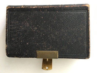 Warrnambool and District Historical Society Inc.
Book, Holy Bible, 19th century
... land agent and a rate collector before he established a bookstore in Timor Street in the 1860s. He was heavily involved in community affairs, being a local Councillor and Mayor in 1868-9. He was also an early commercial photographer in Warrnambool. This small Bible is of great interest because of its connection ...This Bible was owned by Janet Hose (nee Murfitt) 1856-1947. She was married to George Hose and they lived in Warrnambool for all of their married life. They had eleven children and all the births and some of the deaths of the children are recorded in this little Bible. The book was purchased from James Hider who had been a carpenter, a land agent and a rate collector before he established a bookstore in Timor Street in the 1860s. He was heavily involved in community affairs, being a local Councillor and Mayor in 1868-9. He was also an early commercial photographer in Warrnambool. This small Bible is of great interest because of its connection to the Hose family in Warrnambool. In the book are recorded the births and deaths of members of the Hose family. It was a common custom in the 19th century to include family history details in family Bibles and some larger-style Bibles had pages specifically printed to include family history material. This Bible is also of antiquarian interest, an attractive item with its leather cover and gold clasp.This is a mottled brown leather-covered Bible of 840 pages. The pages are gilt-edged and there is a gold metal clasp to close over the pages. Inside the front and back pages there are signatures and other handwritten material, some written in black ink and some in pencil. There is also a label from the Warrnambool book shop and stationery store of James Hider. The inscription pages and the front cover are stained. The cover is also rubbed. ‘J.Hider Opposite the Post Office Warrnambool’ ‘Janet Hose 19/07, 78,83 (Plus the family history details of the Hose Family, mostly on the back pages) janet and george hose, history of warrnambool, hose family -
 Warrnambool and District Historical Society Inc.
Chain link measure, Gunter, Early 20th century
... land measuring tool that was used for over 250 years and has great historical and mathematical significance. A Gunter’s Chain would have been used when forming and building local roads from the earliest days of settlement. 2. It has a possible local connection ...This Gunter’s Chain, an old land surveying instrument, is named after its inventor, Edmund Gunter (1581-1626), an English mathematician and astronomer. It was first produced in 1620. The tool has 100 links and is 66 feet or one chain long. The links are marked off in groups of ten by metal rings or tags. A quarter chain (25 links) is called a rod or pole and ten chains make a furlong and 80 chains make a mile. The traditional cricket pitch is 22 yards or one chain long. This Gunter’s Chain is of considerable significance because: 1. It is an early land measuring tool that was used for over 250 years and has great historical and mathematical significance. A Gunter’s Chain would have been used when forming and building local roads from the earliest days of settlement. 2. It has a possible local connection as it was given to the Historical Society by a local person in 1965 and possibly came from the property of ‘Rosehill’ This is a metal tool which consists of 100 metal pieces or links joined together by loops at each end with two metal loops in between each link. The links joined together form a chain. The two ends of the chain have small metal handles attached At intervals along the chain there are additional rings or metal pieces attached. Some white and green rope material has been used to bundle up the chain. The metal is somewhat rusted. gunter’s chain, land measurement tools, history of warrnambool -
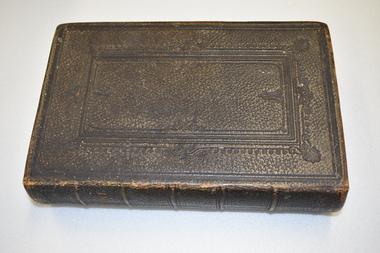 Warrnambool and District Historical Society Inc.
Book, Welsh Bible, 1864
... land "Acme" farm. Their other children Margaret, Jane, Evan, Lewis and Elizabeth were born there." The Memorial card provides the additional information that Sarah Morgan died July 30th 1906 at the age of 68. The date of the Bible 1864 fits with their arrival in Australia in 1865. The Morgan family have been connected to Allansford from that time. This bible has significance social and historical significance as the Bible was common in many family homes. This one written in Welsh shows the connection ...As written in the note inserted in the front of the bible ,"This Welsh Bible was brought to Australia by John Morgan and his wife Sarah in 1865. With baby daughter Mary, they settled at Allansford, where John took up land "Acme" farm. Their other children Margaret, Jane, Evan, Lewis and Elizabeth were born there." The Memorial card provides the additional information that Sarah Morgan died July 30th 1906 at the age of 68. The date of the Bible 1864 fits with their arrival in Australia in 1865. The Morgan family have been connected to Allansford from that time. This bible has significance social and historical significance as the Bible was common in many family homes. This one written in Welsh shows the connection between the origins of the Morgan family and their new country. It is well provenanced and is well connected to the district.Dark brown leather cover over card.The pages are edged in gold and the front and and back covers have a rectangular scrolled design . The pages are not numbered.There is an envelope inside the front cover with a George Hose docket for threshing wheat, barley and oats and an In Memoriam card for Sarah Morgan who dies July 30th 1906. There is also a handwritten note with the owners details and a navy ribbon which may have been attached at one time.There are no inscriptions on the bible itself but the handwritten card reads, " This Welsh Bible was brought to Australia by John Morgan and his wife Sarah in 1865. With baby daughter Mary, they settled at Allansford, where John took up land"Acme" farm. Their other children Margaret, Jane, Evan, Lewis and Elizabeth were born there. There is also an envelope dated 2004 and addressed to Mr Bill Morgan 6 Vera St Iluka NSW 2466. Watkins Binder label inside the back cover.allansford, welsh bible, morgan family, sarah and john morgan -
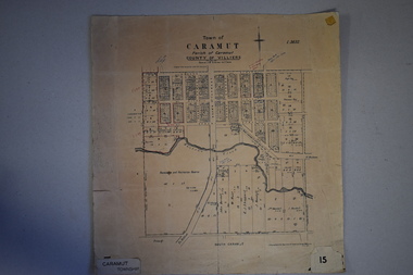 Warrnambool and District Historical Society Inc.
Map, Department of Lands and Survey (Lithographers), Caramut township, 1938
... connection with both their official Shire duties and their private businesses. The last owner of the map was the surveyor, Michael Hand who took over the business of Rolf Crawley in the late 1960s. This map is of great interest firstly because it has all the historical details of the land ...This map of the township of Caramut was produced in 1938 but shows the original land owners of each town allotment and of the surrounding area. The size of all the allotments and the date of the original purchase are also shown. Caramut is a Victorian Western District town on Mustons Creek on the Hamilton Highway 48 kilometres from Warrnambool. This map was used by Rolf Crawley when he was the engineer for the Shire of Warrnambool from 1935 to 1968. The annotations on the map have probably been made by Rolf Crawley as they refer to the records and letter books of his father, John William Crawley, Junior (Shire of Warrnambool Engineer 1895 to 1935). Both Rolf Crawley and his father, John had private businesses as architects, surveyors and engineers and the map could have been used in connection with both their official Shire duties and their private businesses. The last owner of the map was the surveyor, Michael Hand who took over the business of Rolf Crawley in the late 1960s. This map is of great interest firstly because it has all the historical details of the land first purchased in the town of Caramut and area and secondly because it came from the office of Rolf Crawley, the engineer for the Shire of Warrnambool from 1935 to 1968. This is a buff-coloured paper map with a cloth backing. The map details are in black and white print. There are some handwritten red and black annotations on the map. “Town of Caramut Parish of Caramut County of Villiers’town of caramut, john william crawley junior, warrnambool, rolf crawley, warrnambool -
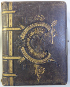 Warrnambool and District Historical Society Inc.
Album - Portrait photos Frisch, Circa 1888
... There are also a number of photographs depicting land clearing and wood cutting also a couple of cards, one happy New year and Glaedelig Jul( Danish Merry Christmas) An album typical of the era with local family connections as well as work by local photographers Warrnambool Warrnambool photographers Lovewell & Co Jordan photographers Daniel Clarke thom wickham e m fleming henry frisch stanley frisch Jan 17th 1888. ...A collection of photographs depicting numerous people. Some have been taken by studios such as Lovewell & Co, Hider, Jordan and Daniel Clarke of Warrnambool. Most of the photos are unnamed but of those that are there is a Thom Wickham, E. M. Fleming, Henry and Stanly Frisch. There are also a number of photographs depicting land clearing and wood cutting also a couple of cards, one happy New year and Glaedelig Jul( Danish Merry Christmas)An album typical of the era with local family connections as well as work by local photographersBrown leather cover with gold figure work over embossing on the front with possibly the letter,”C”. The back cover is entirely embossed. Edges of metal clasp are on front and back cover but clasp part is missing. Gold edges to pages, which are all heavy card. Front inside page has pink briar roses with “Album” on card inserted through it.Jan 17th 1888. To Morris from H Bambrick?warrnambool, warrnambool photographers, lovewell & co, jordan photographers, daniel clarke, thom wickham, e m fleming, henry frisch, stanley frisch -
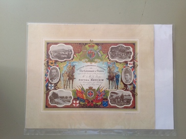 Warrnambool and District Historical Society Inc.
Certificate - Royal Review 1901 G Rolfe, 1901
... connection with the Federation of the six States of Australia in 1901 – The Royal Review at Flemington Racecourse on 10th May 1901. The invitation to attend the event was issued by the Government of Victoria. The certificate was intended to be kept as a souvenir of the event and framed. This particular certificate was issued to George Rolfe and his wife of Warrnambool. George Rolfe (1836-1919), a tea merchant from Melbourne, began buying blocks of land...connection with the Federation of the six States of Australia in 1901 – The Royal Review at Flemington Racecourse on 10th May 1901. The invitation to attend the event was issued by the Government of Victoria. The certificate was intended to be kept as a souvenir of the event and framed. This particular certificate was issued to George Rolfe and his wife of Warrnambool. George Rolfe (1836-1919), a tea merchant from Melbourne, began buying blocks of land ...This certificate was sent to those who had been present at one of the celebrations in connection with the Federation of the six States of Australia in 1901 – The Royal Review at Flemington Racecourse on 10th May 1901. The invitation to attend the event was issued by the Government of Victoria. The certificate was intended to be kept as a souvenir of the event and framed. This particular certificate was issued to George Rolfe and his wife of Warrnambool. George Rolfe (1836-1919), a tea merchant from Melbourne, began buying blocks of land near the mouth of the Hopkins River in Warrnambool in the 1870s. By the early 1880s he had acquired 50 acres of land in the town and several farming properties. He used the buildings on the land near the mouth of the Hopkins River as holiday accommodation and called the property, Lyndoch. He improved the property by adding stables, chaff and bone sheds, jetty, boathouse, reservoir, water well and windmill and extensive gardens and he spent most of his later life in the Warrnambool area. Lyndoch today is the site of an aged care facility. This certificate is of considerable importance for two reasons: 1. It is an important memento of a signal event on Australia’s history – the Federation of the six States in 1901 and the subsequent celebrations. 2. The certificate was issued to a prominent Warrnambool person, George Rolfe and his wife.This is multi-coloured sheet of paper mounted on card. There are four black and white photographs of the Royal Review at Flemington and photographs of the Duke and Duchess of Cornwall and York. The images include the Royal Crest, the shields of the six Australian States, a shield of Victoria with a background of flags, cannon and ammunition, two mounted soldiers with a soldier and sailor standing nearby and swords and bayonets. There is also much colour decoration around the edges of the certificate. The names of Mr and Mrs Rolfe are handwritten in black ink. ‘Australian Commonwealth Celebrations’ ‘The Government of Victoria requests the honour of the presence of Mr & Mrs G. Rolfe at the Royal Review at Flemington on Friday the 10th of May 1901’ federation of australian states, george rolfe of lyndoch, history of warrnambool, george rolfe -
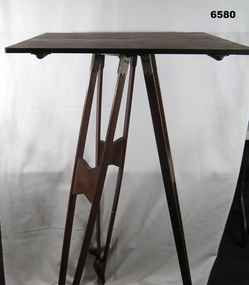 Bendigo Military Museum
Instrument - Survey Plane Table with Tripod, Circa 1910
... The base, a three-legged Tripod, is designed to support the table over a specific point on land. The connection between the tabletop and the adjustable Tripod legs permits the user to level the table precisely, using bubble levels in a horizontal plane regardless of the roughness of the terrain. ...The base, a three-legged Tripod, is designed to support the table over a specific point on land. The connection between the tabletop and the adjustable Tripod legs permits the user to level the table precisely, using bubble levels in a horizontal plane regardless of the roughness of the terrain. ...A Plane Table consists of a smooth wooden table surface (with metal strengthening supports) mounted on a sturdy base. The base, a three-legged Tripod, is designed to support the table over a specific point on land. The connection between the tabletop and the adjustable Tripod legs permits the user to level the table precisely, using bubble levels in a horizontal plane regardless of the roughness of the terrain. The Plane Table is a surveying device used in surveying and mapping to provide a level surface on which to make drawings, charts or maps. An alidade, with or without a telescope located on the tabletop is used to sight features and draw angles to that feature. Using these lines to the same feature from different setup locations it is possible to locate that feature on the map. Plane Tabeling was widely used by the early members of the Australian Survey Corps and in both World Wars. It remains a simple and effective tool to teach the fundamentals of mapping and surveying. It was simple to use and was reasonably robust and portable. See also item 6489.2 for the Plane Table Alidade.A wooden Plane Table with alloy fittings to strengthen and support the table top. The table is fixed to a three-legged wooden Tripod with cast alloy fittings and metal pointed tips.royal australian survey corps, rasvy, fortuna, army survey regiment, army svy regt, asr, 4 fd svy sqn, school of military survey -
 Kiewa Valley Historical Society
Papers - Hollonds' Family and their memories, 2013
... land in Tawonga, Tawonga South and between the East and West of the Kiewa river. Hollonds had a cattle run on Mt Fainter which was later given to the Hicks family. Members of the Hollonds family lived, worked and married in the Kiewa Valley. These papers describe the connection ...The Hollonds' family were original settlers in the Kiewa Valley at Mulagong. Their descendants owned land in Tawonga, Tawonga South and between the East and West of the Kiewa river. Hollonds had a cattle run on Mt Fainter which was later given to the Hicks family.Members of the Hollonds family lived, worked and married in the Kiewa Valley. These papers describe the connection to the families and the Kiewa Valley.Typed papers donated by the Hollonds' family covering: The Hollonds Family History, Cattlemen, 'Snowy' Miller, Mrs Hollonds' Boarding house, SEC Depot at Tawonga, building of Bogong Township, Early Scenes on the Kiewa Scheme.hollonds family, tawonga station, cattlemen, mt beauty land, tawonga boarding house -
 Emerald Museum & Nobelius Heritage Park
Map - Plan of Survey - Nobelius Heritage Park 2013, L. Nobelius, Nobelius Heritage Park, Plan of Survey 2013, c2013
... Nobelius Historical connection between surveyor and the park's creator Topographical map of Nobelius Heritage Park/Denotes tree positions/Scale 1:1000 (A3)/drawn by L.NOBELIUS 20/3/2013/Survey Ref Number 5884/Nobelius Land Surveyors, PO Box 461, Pakenham 3810, Ph 03 9541 4112 Image of Plan of Survey of Nobelius Heritage Park, Emerald Nobelius Heritage Park, Plan of Survey 2013 Map Plan of Survey - Nobelius Heritage Park 2013 L. ...Survey map printed by L. NobeliusHistorical connection between surveyor and the park's creatorImage of Plan of Survey of Nobelius Heritage Park, EmeraldTopographical map of Nobelius Heritage Park/Denotes tree positions/Scale 1:1000 (A3)/drawn by L.NOBELIUS 20/3/2013/Survey Ref Number 5884/Nobelius Land Surveyors, PO Box 461, Pakenham 3810, Ph 03 9541 4112