Showing 16 items matching "contractors level"
-
 Federation University Historical Collection
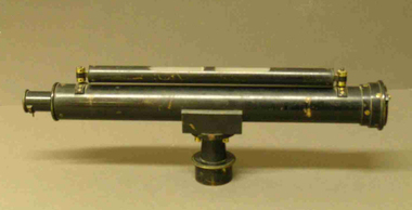
Equipment - Scientific Instruments, Level
... ...contractors level...scientific instruments level contractors level ballarat school of mines surveying mining A sensitive optical levelling instrument in a polished timber carry case. ...A sensitive optical levelling instrument in a polished timber carry case. Instrument to be mounted on a tripod with 3.5 cm male thread. Matches Tripod Catalogue Number 4111.scientific instruments, level, contractors level, ballarat school of mines, surveying, mining -
 St Kilda Historical Society
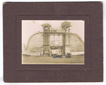
Photograph, George Walles & Co, Luna Park, 10/5/1912
... Construction of Entrance and Switch Back Railway, Luna Park, St Kilda, October 1912; onion dome on one side, not the other; two early motor vehicles with spoke wheels; construction crew on top level; sign 'Contractors The G.A. Lawsha Contruction Co. ...St Kilda Historical Society St Kilda Branch Library 150 Carlisle Street St Kilda melbourne Construction of Entrance and Switch Back Railway, Luna Park, St Kilda, October 1912; onion dome on one side, not the other; two early motor vehicles with spoke wheels; construction crew on top level; sign 'Contractors The G.A. Lawsha Contruction Co. ...Construction of Entrance and Switch Back Railway, Luna Park, St Kilda, October 1912; onion dome on one side, not the other; two early motor vehicles with spoke wheels; construction crew on top level; sign 'Contractors The G.A. Lawsha Contruction Co. London, Engineer T.h. Eslick'black and white photograph, mounted, poor conditionLuna Park 5/1/0/12 Switch back Railway [trikethrough text 'afterwards called Big Dipper']; [stamp] George Wall & Co, Photo Experts, 131 Chapel St., Balaclava (near Melbourne) Photoas copied, resuscitated and enlarged. -
 Warrnambool and District Historical Society Inc.
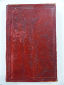
Book, John Ross notebook, 1890s
... The book lists the levels taken for the benefit of contractors undertaking jobs for the Warrnambool Council from 1898 to 1902. ...The book lists the levels taken for the benefit of contractors undertaking jobs for the Warrnambool Council from 1898 to 1902. ...This small note book belonged to John Ross, the Warrnambool Town Surveyor and Engineer (1889-1906 & 1913-1914). The book lists the levels taken for the benefit of contractors undertaking jobs for the Warrnambool Council from 1898 to 1902. The jobs include ‘Russells Creek from the Merri River upwards’, ‘Outlet at the Flume’, ‘Guns at the Battery’ and Drainage from the Terminus Hotel to the end of the Japan Street Tunnel’. John Ross was also in private practice with the architectural firm of Ross and Jackman. This notebook is of considerable interest because it is an original note book that belonged to John Ross, the Warrnambool Town Surveyor and Engineer in the late 19th century and early 20th century. The note book contains important information on the engineering projects in Warrnambool and district from 1898 to 1902. This note book has a red leather cover. The cover is a little creased. The inside pages have ruled red lines and printed headings regarding the levels taken of a site and the location of the site (1898 to 1902). The engineer’s entries in the printed columns are handwritten , mostly in pencil. The inscription on the first page is handwritten in black ink. ‘Jno C Ross, Town Surveyor Wbool 19/5/98’ john ross, warrnambool town council, history of warrnambool -
 Kiewa Valley Historical Society
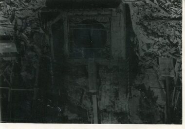
Photo - Junction Dam Diversion Tunnel
... contractor and the work was taken over by the S.E.C., terminating the contract. The dam was completed in March, 1944. A walkway was made through the dam wall. Lake Guy was named after Mr. L.T. Guy who was the Resident engineer, in charge of construction work and associated activities on the Kiewa Area from 1939 to November 1946. Diversion dams are installed to raise the water level ...Junction (Lake Guy) Dam is a 'slab and buttress' type wall. A timber frame is built and then filled with concrete. The first batch of concrete was placed in September, 1940. By June, 1941 the buttresses were finished to a height safe from floods and in October of that year a flood of 2,800 cusecs occurred but with only slight damage to the installations. Industrial trouble caused some delays but there was also slow progress on the part of the contractor and the work was taken over by the S.E.C., terminating the contract. The dam was completed in March, 1944. A walkway was made through the dam wall. Lake Guy was named after Mr. L.T. Guy who was the Resident engineer, in charge of construction work and associated activities on the Kiewa Area from 1939 to November 1946.Diversion dams are installed to raise the water level of a body of water to be redirected. The redirected water is used for hydro electric power generation. A diversion tunnel is usually bored through solid rock next to the dam site to bypass the dam construction site. The dam is built while the river flows through the diversion tunnel.Photos of the construction of the Junction Dam detail the harsh conditions faced by construction workers, building dams and villages to accommodate workers in the 1940s to the 1950s. Australia at this period in time, experienced a surge of population (influx of World War II refugees), which was the catalyst for developing and undergoing an enormous hydroelectricity program for the Alpine regions, both in Victoria and New South Wales. This program was initiated to supply electricity to the major southern Australian cities of Adelaide, Melbourne and Sydney. It was thought that these developments would reduce, if not eliminate, the requirement for coal driven power stations. However time has demonstrated that these power stations have not matched the demand required by the industries and the populations of the major urban and cities.Black and white photograph of Junction Dam diversion tunnel at Bogong VillageHandwritten on back - Junction Dam Diversional Tunnelbogong, secv, junction dam, lake guy -
![Newspaper Clipping, Bridge is rail big effort [Rosanna], 11/04/2018](/media/collectors/4f729f5697f83e03086015b8/items/5aed3a8221ea670268548c06/item-media/5b4ad49921ea670f143ddf21/item-fit-380x285.jpg?cb=6) Greensborough Historical Society
Greensborough Historical SocietyNewspaper Clipping, Bridge is rail big effort [Rosanna], 11/04/2018
... The mammoth rail bridge has been installed across Lower Plenty Road in Rosanna by Level Crossing Removal Authority contractors....Greensborough Historical Society 34A Glenauburn Road Lower Plenty Lower Plenty melbourne The mammoth rail bridge has been installed across Lower Plenty Road in Rosanna by Level Crossing Removal Authority contractors. level crossing removal project rail bridge lower plenty road rosanna rosanna station hurstbridge rail line News article 1 page, black text and colour image . ...The mammoth rail bridge has been installed across Lower Plenty Road in Rosanna by Level Crossing Removal Authority contractors.News article 1 page, black text and colour image .level crossing removal project, rail bridge, lower plenty road rosanna, rosanna station, hurstbridge rail line -
 Eltham District Historical Society Inc
Postcard - Photograph postcard, Old Bridge, Kaylock's Crossing, Brougham Street, Eltham, c.1912
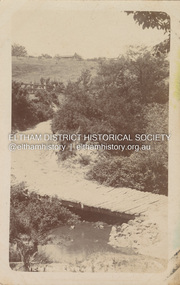
... The tender was awarded to Mr Weller of Kangaroo Ground who commenced work in February 1923 on a higher-level timber trestle bridge. Work was slowed due to illness of the contractor and the accidental death of a man in March 1923 following the collapse of the bank after he had jumped into a hole that had just been blasted. ...The tender was awarded to Mr Weller of Kangaroo Ground who commenced work in February 1923 on a higher-level timber trestle bridge. Work was slowed due to illness of the contractor and the accidental death of a man in March 1923 following the collapse of the bank after he had jumped into a hole that had just been blasted. ...Date estimated to be circa 1912 based on the style of printing on the reverse of the card - Kodak Austral paper for real photo postcards, the paper was manufactured c.1908-1914 (See also POSTCARDS ON KODAK PAPER - IS IT POSSIBLE TO "DATE" THEM? http://tps.org.au/bb/viewtopic.php?t=115) Brougham Street was created in Josiah Holloway's 1851 subdivision of Little Eltham. It was one of several east-west streets shown on the subdivision plan as crossing the Diamond Creek. The western part was named Wellington Street on the subdivision plan but was later changed to conform with the name of the eastern part as acknowledgement of the continuity of the street. It is not known when the first bridge was constructed in Brougham Street however it was certainly mentioned at Council’s meeting of 2 June 1884 as being in a dangerous state of repair. This photo (c.1895) of an old bridge shows a very low-level simple log girder bridge crossing the creek at a right angle and so the approaches involved bends in the road alignment. This bridge was generally known as Kaylocks Bridge or Kaylock’s Crossing after the owner of the adjoining land. It was most likely built from around the mid-1850s, or a crossing of some fashion established as Richard George Kaylock, butcher of Little Eltham and his wife Emily Ann settled there in 1854. His property was in Wellington Street (now Brougham Street) and apparently extended across the Diamond Creek. The land on the western side of the creek was farmed, the house being on the eastern side. Kaylock's Bridge formed part of the original coach road to Eltham and in 1922 was described as an "old rustic bridge". Its low level and insubstantial construction made it susceptible to flood damage, necessitating frequent closures until repairs could be carried out. In September 1922, Council called for tenders for a new timber bridge to be constructed at Kaylock’s crossing. An engineering assessment carried out for the Council by Macleod Consulting at the time of the replacement suggested that the construction details indicate that it was in the 1900s, however this dating could possibly have been the result of numerous repairs undertaken over the years to flood damage. The tender was awarded to Mr Weller of Kangaroo Ground who commenced work in February 1923 on a higher-level timber trestle bridge. Work was slowed due to illness of the contractor and the accidental death of a man in March 1923 following the collapse of the bank after he had jumped into a hole that had just been blasted. The bridge was completed around July 1923 at which point the old structure was pulled up, marking what was described in the ‘Advertiser’ newspaper as the passing of an old and well-loved landmark in the district. In April 1924 the approach to Kaylocks bridge was washed away during the heavy flooding that destroyed the Main Road bridge. The western side was repaired, and an extra span was added to the eastern side using timber from the destroyed Main Road bridge. The bridge was again severely damaged four months later in August 1924 When a lack of finances delayed repairs to the Bridge Street bridge in 1931 (also referred to as Obelisk Bridge at the time), traffic had to detour via Brougham Street for some time. Local residents feared that the Bridge Street bridge might never reopen. Kaylocks Bridge was constantly subject to damage by floods. In the 1934 flood it was submerged by two feet of water. In more recent times the bridge was again severely damaged by flooding and repairs made. A new bridge and adjoining footbridge were constructed in 2009.Digital file only Postcards scanned from the collection of Michael Aitken on loan to EDHS, 2 Sep. 2022michael aitken collection, eltham, postcards, bridge, brougham street, diamond creek (creek), kaylocks bridge, wellington street -
 Eltham District Historical Society Inc
Photograph, Old Bridge, Kaylock's Crossing, Brougham Street, Eltham, c.1895
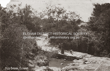
... The tender was awarded to Mr Weller of Kangaroo Ground who commenced work in February 1923 on a higher-level timber trestle bridge. Work was slowed due to illness of the contractor and the accidental death of a man in March 1923 following the collapse of the bank after he had jumped into a hole that had just been blasted. ...The tender was awarded to Mr Weller of Kangaroo Ground who commenced work in February 1923 on a higher-level timber trestle bridge. Work was slowed due to illness of the contractor and the accidental death of a man in March 1923 following the collapse of the bank after he had jumped into a hole that had just been blasted. ...Brougham Street was created in Josiah Holloway's 1851 subdivision of Little Eltham. It was one of several east-west streets shown on the subdivision plan as crossing the Diamond Creek. The western part was named Wellington Street on the subdivision plan but was later changed to conform with the name of the eastern part as acknowledgement of the continuity of the street. It is not known when the first bridge was constructed in Brougham Street however it was certainly mentioned at Council’s meeting of 2 June 1884 as being in a dangerous state of repair. This photo (c.1895) of an old bridge shows a very low-level simple log girder bridge crossing the creek at a right angle and so the approaches involved bends in the road alignment. This bridge was generally known as Kaylocks Bridge or Kaylock’s Crossing after the owner of the adjoining land. It was most likely built from around the mid-1850s, or a crossing of some fashion established as Richard George Kaylock, butcher of Little Eltham and his wife Emily Ann settled there in 1854. His property was in Wellington Street (now Brougham Street) and apparently extended across the Diamond Creek. The land on the western side of the creek was farmed, the house being on the eastern side. Kaylock's Bridge formed part of the original coach road to Eltham and in 1922 was described as an "old rustic bridge". Its low level and insubstantial construction made it susceptible to flood damage, necessitating frequent closures until repairs could be carried out. In September 1922, Council called for tenders for a new timber bridge to be constructed at Kaylock’s crossing. An engineering assessment carried out for the Council by Macleod Consulting at the time of the replacement suggested that the construction details indicate that it was in the 1900s, however this dating could possibly have been the result of numerous repairs undertaken over the years to flood damage. The tender was awarded to Mr Weller of Kangaroo Ground who commenced work in February 1923 on a higher-level timber trestle bridge. Work was slowed due to illness of the contractor and the accidental death of a man in March 1923 following the collapse of the bank after he had jumped into a hole that had just been blasted. The bridge was completed around July 1923 at which point the old structure was pulled up, marking what was described in the ‘Advertiser’ newspaper as the passing of an old and well-loved landmark in the district. In April 1924 the approach to Kaylocks bridge was washed away during the heavy flooding that destroyed the Main Road bridge. The western side was repaired, and an extra span was added to the eastern side using timber from the destroyed Main Road bridge. The bridge was again severely damaged four months later in August 1924 When a lack of finances delayed repairs to the Bridge Street bridge in 1931 (also referred to as Obelisk Bridge at the time), traffic had to detour via Brougham Street for some time. Local residents feared that the Bridge Street bridge might never reopen. Kaylocks Bridge was constantly subject to damage by floods. In the 1934 flood it was submerged by two feet of water. In more recent times the bridge was again severely damaged by flooding and repairs made. A new bridge and adjoining footbridge were constructed in 2009. Part of a slide show presentation "Bridges & Waterways of the Shire" by Russell Yeoman to the 13 September 1989 Society meeting. The presentation included slides of historic photos from the Shire of Eltham Pioneers collections as well as several recent views.Photo of earliest known crossing of the Diamond Creek at brougham StreetPostcard photo printbrougham street, eltham, wellington street, kaylocks bridge, bridge, diamond creek (creek) -
 Bendigo Historical Society Inc.
Document - CASTLEMAINE GAS COMPANY COLLECTION: MEETING MINUTES
... Levels of Authority to be followed. By the managers for: General work - Appliance Installation and Schedule of rates Main laying and Service laying. Attached are 2 copies of quotation forms, 2 copies of OL5 Outside Labour procedure exemption request and 2 copies of a contractor form that the contractor must sign to indemnified Gas&Fuel against loss or damage caused by contractor...Levels of Authority to be followed. By the managers for: General work - Appliance Installation and Schedule of rates Main laying and Service laying. Attached are 2 copies of quotation forms, 2 copies of OL5 Outside Labour procedure exemption request and 2 copies of a contractor form that the contractor must sign to indemnified Gas&Fuel against loss or damage caused by contractor Document CASTLEMAINE GAS COMPANY COLLECTION: MEETING MINUTES ...Branch and area managers meeting held on the 21st September 1981. Outside Labour Order and Expenditure Procedure. The document outlines the Levels of Authority to be followed. By the managers for: General work - Appliance Installation and Schedule of rates Main laying and Service laying. Attached are 2 copies of quotation forms, 2 copies of OL5 Outside Labour procedure exemption request and 2 copies of a contractor form that the contractor must sign to indemnified Gas&Fuel against loss or damage caused by contractordocument, memo, minutes -
 Bendigo Historical Society Inc.
Document - ARTICLES FOR ROYAL HISTORICAL SOCIETY (BENDIGO BRANCH) JUNE 1973
... level); 2. Specimen Hill Methodist Church - mention of Mining Inspector Grainger; Mr Widdox; Blazier (Braizer)?? & Co - contractors...level); 2. Specimen Hill Methodist Church - mention of Mining Inspector Grainger; Mr Widdox; Blazier (Braizer)?? & Co - contractors ...Articles for Royal Historical Society (Bendigo Branch) June 1973. 1. Article re two aspects of New Chum Railway mine - a. the shaft has a 180 degree 'twist' in it; b. ventilation problems at depth (4236 feet level); 2. Specimen Hill Methodist Church - mention of Mining Inspector Grainger; Mr Widdox; Blazier (Braizer)?? & Co - contractors; Rev. Rankin; Mr Manley; Brass Band; Rev. Winn. 2. ''The new bells - St Paul's Church, Bendigo'' - mention of Mears and Stainbank (Bell Foundry, Whitechapel, London); Rt Rev R E Richards (Bishop of Bendigo); re-casting of bells 1964. 3. Article re artificial ventilation re West Berry Consols Mine (Allendale) and use of a Roots Blower. 4. Article ''It slowly fades away'' re demolition of 46 Lucan Street (see also Moaic #2860) - mention of Thunders Brewery; Bendigo Cognac Distillery; Cyril Michelsen; John Michelsen; description of vats and layout of site.document, names of bendigo pioneers, bendigo -
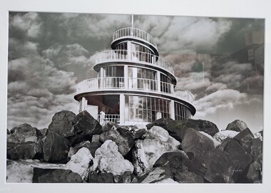 Glenelg Shire Council Cultural Collection
Photograph, John Wilkins, Photographer, Corkscrew, n.d
... contractors who constructed the port. It was designed in 1960 and fabricated shortly after the completion of the Main Breakwater. The corkscrew was built as an observatory, with the observation deck approximately 13 metres above sea level. ...contractors who constructed the port. It was designed in 1960 and fabricated shortly after the completion of the Main Breakwater. The corkscrew was built as an observatory, with the observation deck approximately 13 metres above sea level. ...From the Port of Portland website: The original corkscrew was built as a gift to the Portland Harbour Trust by the contractors who constructed the port. It was designed in 1960 and fabricated shortly after the completion of the Main Breakwater. The corkscrew was built as an observatory, with the observation deck approximately 13 metres above sea level. Its original design life was less than 25 years. The original structure was dilapidated, extremely unsafe and in danger of collapse. Understanding the historical and community importance of the original structure, in 2016 Port of Portland began the process of designing and building a replacement. The new corkscrew is a similar size and has been based on the same spiral shape of the original structure. The corkscrew has been constructed using mild steel, heavily coated in marine grade paint (similar to what is used on ships). Heavy duty plastic has been used for the walkway section which will withstand the harsh elements of the marine environment.Photograph of the Portland Corkscrew in the 1980s. Image is in black and white. The corkscrew is in front of a sky which is dotted with fluffy clouds. To the front of the Corkscrew are large rocks. The building is a spiral with glass windows. There is a white metal fence around it and a white pole at the top which reaches to the top of the image.Bottom right: J WILKINSportland, seafront, maritime, portland landmark, corkscrew, port of portland, portland photography, photography -
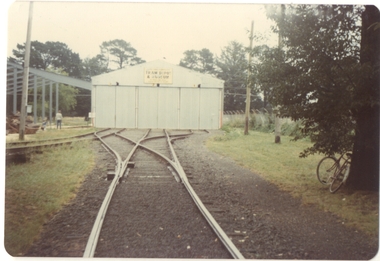 Ballarat Tramway Museum
Photograph - Colour Print/s - set of 4, Stephen Butler, early 1979
... contractor. Printed on Kodak paper. .1 - view of shed and extension from level crossing .2 - ditto - from in front of new shed .3 - ditto .4 - looking along access track....contractor. Printed on Kodak paper. .1 - view of shed and extension from level crossing .2 - ditto - from in front of new shed .3 - ditto .4 - looking along access track. ...Yields information about the construction of the BTPS Depot extensions early 1979.Set of 4 colour prints of tram the depot extensions being constructed early 1979 - steelwork erected, but no cladding due to the failure of the contractor. Printed on Kodak paper. .1 - view of shed and extension from level crossing .2 - ditto - from in front of new shed .3 - ditto .4 - looking along access track.trams, tramways, btps, depot extensions -
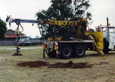 Ballarat Tramway Museum
Photograph - Colour Photograph/s, Carolyn Dean, 1/03/2000 12:00:00 AM
... Clark contractor - taken on 24 March 2000. .2 - ditto .3 - ditto .4 - ditto .5 - ditto .6 - Briefing session prior to starting work - left to right - Kevin Taig, Warren Doubleday, John Phillips, Phillip Bertram, Len Millar, Darren Hutchesson, Simon Jenkins, Alan Snowball and Glen Parkhill. - taken on 25 March 2000. .7 - setting out the frames .8 - positioning the rear frame of the first shed. .9 - ditto .10 - ditto .11 - positioning the 3rd frame of the first shed. .12 - leveling up the front of the first shed. .13 - positioning the rear frame of the second shed - taken on 26 March 2000. .14 - ditto - left to right - John Phillips, Darren Hutchesson, Peter Winspur, Len Millar, Simon Jenkins, Warren Doubleday, Alan Snowball, Alastair Reither, Kevin Taig. .15 - ditto .16 - tent city at the Bungaree House. .17 - the two shed frames complete - taken on 27 March 2000. .18 - ditto .19 - Jim Parker stripping paint of the rear of the Bungaree House. .20 - Pouring concrete .21 - ditto .22 - ditto .23 - ditto .24 - ditto - Kevin Taig .25 - Finishing off - John Phillips and Kevin Taig. ...Clark contractor - taken on 24 March 2000. .2 - ditto .3 - ditto .4 - ditto .5 - ditto .6 - Briefing session prior to starting work - left to right - Kevin Taig, Warren Doubleday, John Phillips, Phillip Bertram, Len Millar, Darren Hutchesson, Simon Jenkins, Alan Snowball and Glen Parkhill. - taken on 25 March 2000. .7 - setting out the frames .8 - positioning the rear frame of the first shed. .9 - ditto .10 - ditto .11 - positioning the 3rd frame of the first shed. .12 - leveling up the front of the first shed. .13 - positioning the rear frame of the second shed - taken on 26 March 2000. .14 - ditto - left to right - John Phillips, Darren Hutchesson, Peter Winspur, Len Millar, Simon Jenkins, Warren Doubleday, Alan Snowball, Alastair Reither, Kevin Taig. .15 - ditto .16 - tent city at the Bungaree House. .17 - the two shed frames complete - taken on 27 March 2000. .18 - ditto .19 - Jim Parker stripping paint of the rear of the Bungaree House. .20 - Pouring concrete .21 - ditto .22 - ditto .23 - ditto .24 - ditto - Kevin Taig .25 - Finishing off - John Phillips and Kevin Taig. ...Set of 25 photographs taken over the period 24 March 2000 to 27 March 2000 of BTM members working on the erection of the frames for the Bungaree off site storage building. All taken by Carolyn Dean on Kodak Paper. Refer to March 2000 Fares Please! for further details. 1344.1 - Drilling the foundation Holes - J.J. Clark contractor - taken on 24 March 2000. .2 - ditto .3 - ditto .4 - ditto .5 - ditto .6 - Briefing session prior to starting work - left to right - Kevin Taig, Warren Doubleday, John Phillips, Phillip Bertram, Len Millar, Darren Hutchesson, Simon Jenkins, Alan Snowball and Glen Parkhill. - taken on 25 March 2000. .7 - setting out the frames .8 - positioning the rear frame of the first shed. .9 - ditto .10 - ditto .11 - positioning the 3rd frame of the first shed. .12 - leveling up the front of the first shed. .13 - positioning the rear frame of the second shed - taken on 26 March 2000. .14 - ditto - left to right - John Phillips, Darren Hutchesson, Peter Winspur, Len Millar, Simon Jenkins, Warren Doubleday, Alan Snowball, Alastair Reither, Kevin Taig. .15 - ditto .16 - tent city at the Bungaree House. .17 - the two shed frames complete - taken on 27 March 2000. .18 - ditto .19 - Jim Parker stripping paint of the rear of the Bungaree House. .20 - Pouring concrete .21 - ditto .22 - ditto .23 - ditto .24 - ditto - Kevin Taig .25 - Finishing off - John Phillips and Kevin Taig. See Fares Please! March 2000bungaree, storage, depot, btm -
 Moorabbin Air Museum
Machine - GAF (Dassault) Mirage IIIO A3-45
... Designed by Avions Marcel Dassault, 116 examples were built under licence by the Government Aircraft Factory as the primary contractor. The wings, fin, tail cone and. Level of Importance: State...Designed by Avions Marcel Dassault, 116 examples were built under licence by the Government Aircraft Factory as the primary contractor. The wings, fin, tail cone and. Level of Importance: State GAF (Dassault) Mirage IIIO A3-45 Machine GAF (Dassault) Mirage IIIO A3-45 ...Historical Details: . Description: The Mirage was Australia’s first truly supersonic jet fighter, entering service in 1965. Designed by Avions Marcel Dassault, 116 examples were built under licence by the Government Aircraft Factory as the primary contractor. The wings, fin, tail cone and. Level of Importance: State -
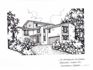 Whitehorse Historical Society Inc.
Artwork, other - Ink Line Drawing, Margaret Picken, 14 Manorwood Plc. Mitcham, 1997
... contractors. This artwork is of Historical Significance as a record of local domestic architecture. Whitehorse Historical Society Schwerkolt Cottage Housing Architecture Margaret Picken House Garden Real Estate Mitcham 14 Manorwood Plc. Mitcham Margaret Picken -97 Woodards - b/burn A black ink line drawing on drafters film by Margaret Picken, of 14 Manorwood Plc. Mitcham depicting a black and white line drawing of a multi level ...A property illustration by Margaret Picken Commissioned by a real estate agency for the purpose of advertising 14 Manorwood Plc. Mitcham. This property is listed as having sold for $240,000 in 1997 Made by using Rotring ‘Rapidigraph’ drafting pens with Rotring ink on Rapidigraph polyester drafting film, double matte. Trained as a cartographic draftsman within the mining industry, Margaret Picken is an artist who worked producing property illustrations for real estate agencies in eastern suburbs of Victoria from 1983-2005. Retiring from the industry as technological changes favored coloured photography over illustrations, and commissioning companies over sole contractors.This artwork is of Historical Significance as a record of local domestic architecture.A black ink line drawing on drafters film by Margaret Picken, of 14 Manorwood Plc. Mitcham depicting a black and white line drawing of a multi level brick house with weatherboard feature at the windows. There is a driveway curving from the righthand side of the foreground up to a built in garage, with garden either side of the driveway. There are two holepunch holes centred just under the upper edge14 Manorwood Plc. Mitcham Margaret Picken -97 Woodards - b/burnwhitehorse historical society, schwerkolt cottage, housing, architecture, margaret picken, house, garden, real estate, mitcham -
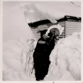 Falls Creek Historical Society
Photograph - Bogong 12 July 1953
... contractor. After a serious work accident, Fred retired in 1985 and moved to Rosebud, Victoria where he died on 19 August 1992. This image is from the Fred Griffith collection which documents the early development of Falls Creek. bogong falls creek snow snowfields Stamped - SUPER / G & D . SERVICE Pencil - 61 Black and white square photograph of man shovelling snow in front of himself. There are high levels ...This photo is part of the Fred Griffith Photographic Collection documenting his time with the Australian Alpine Club and the formation of the Albury Ski Club. Frederick Charles “Fred” Griffith was born in Albury, NSW on 2 March 1910. Educated in Albury and Geelong Grammar. Beginning in 1927 he spent many years working first as a jackeroo and on a range of prominent pastoral and merino stud properties in NSW and Queensland. In 1935 he repurchased his former family property “Toonallook", Bowna, NSW and developed it to be the largest Romney Marsh stud in the world, exporting rams to Argentina. He introduced many innovative practices on his property including rabbit control measures and aerial crop dusting. He was an active member of the Albury Show Society and in 1949 established the Albury Sheep Show. Fred was also the Albury representative on the Graziers’ Association Council for over 30 years. He became a life member of both the Albury and Commercial Clubs. Fred’s greatest hobby was snow skiing. His first visit to the snow was to Kosciusko in 1919. The Albury Ski Club was formed in 1935 and Fred was an inaugural member. In 1949 they were granted a site at Falls Creek to build their own lodge. Fred guaranteed the Club for finance from the Bank of NSW. The first portion of the prefabricated building was constructed in Albury. It was transported to Falls Creek on the back of Fred’s truck and erected in one day. This was the bathroom section and the rest was completed in 1950. The original lodge was burned down in 1952 and a new one built the following year. In 1955, Fred also built the Bowna Lodge for his family in partnership with David Fairbairn. He became head of the North Eastern District Skiing Association (N.E.D.S.A.) and successfully applied to run the Australian Ski Championships. Fred also inaugurated children’s races at Falls Creek and ran them for about 20 years. He also formed the company “Falls Creek Ski Tows”. In 1956 Fred along with a group of key people selected the site for Thredbo Village. Fred and his brother sold Toonallook in sections between 1951 and 1974. He moved to Albury and set up as a landscape gardener and fencing contractor. After a serious work accident, Fred retired in 1985 and moved to Rosebud, Victoria where he died on 19 August 1992. This image is from the Fred Griffith collection which documents the early development of Falls Creek.Black and white square photograph of man shovelling snow in front of himself. There are high levels of snow either side of man and building in the background. Snow is on top of building. Stamped - SUPER / G & D . SERVICE Pencil - 61bogong, falls creek, snow, snowfields -
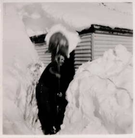 Falls Creek Historical Society
Photograph - Bogong, 1953
... contractor. After a serious work accident, Fred retired in 1985 and moved to Rosebud, Victoria where he died on 19 August 1992. bogong falls creek snow snowfields Stamped - SUPER / G & D . SERVICE Pencil - 61 Black and white square photograph of man shovelling snow with high levels ...This photo is part of the Fred Griffith Photographic Collection documenting his time with the Australian Alpine Club and the formation of the Albury Ski Club. Frederick Charles “Fred” Griffith was born in Albury, NSW on 2 March 1910. Educated in Albury and Geelong Grammar. Beginning in 1927 he spent many years working first as a jackeroo and on a range of prominent pastoral and merino stud properties in NSW and Queensland. In 1935 he repurchased his former family property “Toonallook", Bowna, NSW and developed it to be the largest Romney Marsh stud in the world, exporting rams to Argentina. He introduced many innovative practices on his property including rabbit control measures and aerial crop dusting. He was an active member of the Albury Show Society and in 1949 established the Albury Sheep Show. Fred was also the Albury representative on the Graziers’ Association Council for over 30 years. He became a life member of both the Albury and Commercial Clubs. Fred’s greatest hobby was snow skiing. His first visit to the snow was to Kosciusko in 1919. The Albury Ski Club was formed in 1935 and Fred was an inaugural member. In 1949 they were granted a site at Falls Creek to build their own lodge. Fred guaranteed the Club for finance from the Bank of NSW. The first portion of the prefabricated building was constructed in Albury. It was transported to Falls Creek on the back of Fred’s truck and erected in one day. This was the bathroom section and the rest was completed in 1950. The original lodge was burned down in 1952 and a new one built the following year. In 1955, Fred also built the Bowna Lodge for his family in partnership with David Fairbairn. He became head of the North Eastern District Skiing Association (N.E.D.S.A.) and successfully applied to run the Australian Ski Championships. Fred also inaugurated children’s races at Falls Creek and ran them for about 20 years. He also formed the company “Falls Creek Ski Tows”. In 1956 Fred along with a group of key people selected the site for Thredbo Village. Fred and his brother sold Toonallook in sections between 1951 and 1974. He moved to Albury and set up as a landscape gardener and fencing contractor. After a serious work accident, Fred retired in 1985 and moved to Rosebud, Victoria where he died on 19 August 1992.Black and white square photograph of man shovelling snow with high levels of snow either side of him and a hut behind. There is snow on the roof of the hut. Stamped - SUPER / G & D . SERVICE Pencil - 61bogong, falls creek, snow, snowfields