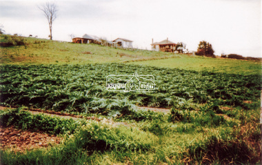
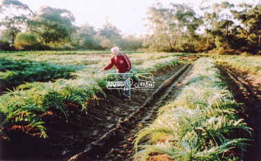
Showing 65 items matching "cropping area"
-
 University of Melbourne, Burnley Campus Archives
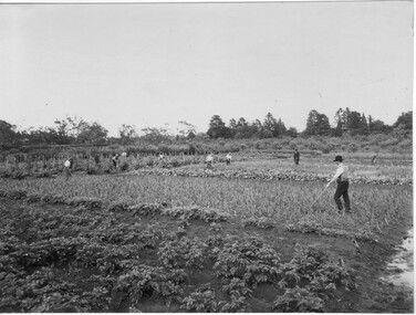
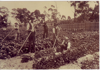
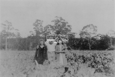
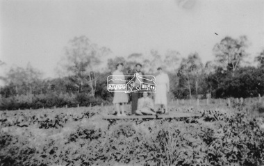
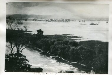
Photograph - Black and white print, Students Working in Cropping Area, 1917-1921
... Students Working in Cropping Area......cropping area...Winzenried, p 36, with the caption, "Cropping area, looking west; the ornamental gardens are to the right, and Heyington railway bridge to the left. ...Students working in cropping area in the Orchard with a Staff member supervising. 2 copies....Students Working in Cropping Area Photograph Black and white print ...Used as an illustration in, "Green Grows Our Garden," A.P. Winzenried, p 36, with the caption, "Cropping area, looking west; the ornamental gardens are to the right, and Heyington railway bridge to the left. The figure with the walking stick is probably J.P. McLennan." Note by T.H. Kneen 10 June 1992, "On later inspection both EBL and THK now doubt that the person "supervising" is McLennan - but the date of the photograph is a reasonable estimate."Black and white photograph. Students working in cropping area in the Orchard with a Staff member supervising. 2 copies.green grows our garden, a.p. winzenried, cropping area, west orchard, students working outside, staff -
 Mt Dandenong & District Historical Society Inc.
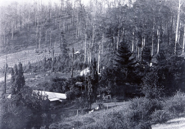
Photograph, Kalorama Guest-house with View of Valley
... Black and white photograph with four buildings visible, cleared crop areas and sparse forest. Washing hangs on a line in the foreground....Barbers Road Guest House Kalorama Guest-house Black and white photograph with four buildings visible, cleared crop areas and sparse forest. Washing hangs on a line in the foreground. ...Looking acoss Kalorama Valley. Roof of Kalorama Guest-house, owned by Ellis and Eliza Jeeves, in foreground with two other houses, forest and cleared section. Taken from Barbers Road. Black and white photograph with four buildings visible, cleared crop areas and sparse forest. Washing hangs on a line in the foreground.barbers road, guest house, kalorama guest-house -
 Lakes Entrance Historical Society
Postcard - Kilmorie - Bruthen, 1900 c
... Sepia toned postcard showing farmland in the Bridle Creek Kilmorie area maize crop with building on flat Bruthen Victoria...Lakes Entrance Historical Society 4 Marine Parade Lakes Entrance gippsland Agriculture Settlement CGR Sepia toned postcard showing farmland in the Bridle Creek Kilmorie area maize crop with building on flat Bruthen Victoria Postcard Kilmorie - Bruthen ...Sepia toned postcard showing farmland in the Bridle Creek Kilmorie area maize crop with building on flat Bruthen VictoriaCGRagriculture, settlement -
 Bendigo Historical Society Inc.
Slide - PETER ELLIS COLLECTION: SLIDE, May 1970 - Jan 1972
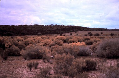
... The words, Wherrakee Wattle Regeneration Lot 18 (Robertson) are handwritten along the bottom border and the words 'Bagshot area Clear area in background was originally cropped. Wattle area was not.' are handwritten along the top border....The words, Wherrakee Wattle Regeneration Lot 18 (Robertson) are handwritten along the bottom border and the words 'Bagshot area Clear area in background was originally cropped. Wattle area was not.' are handwritten along the top border. ...Coloured slide transparency. Image is of a bush area. There is dense medium scrub in the background and dense low growing flowering yellow wattle in the foreground. The words, Wherrakee Wattle Regeneration Lot 18 (Robertson) are handwritten along the bottom border and the words 'Bagshot area Clear area in background was originally cropped. Wattle area was not.' are handwritten along the top border.Kodachrome Transparencyslide, bendigo, bendigo institute of technology -
 University of Melbourne, Burnley Campus Archives
Photograph - Sepia print, A.E. Bennett, Students Hoeing Crops, 1894-1990
... Bennett, c.1894, after p 116. 5 male students working with hoes along lines of vegetable crops in an area bounded by a picket fence....Bennett, c.1894, after p 116. 5 male students working with hoes along lines of vegetable crops in an area bounded by a picket fence. Students Hoeing Crops Photograph Sepia print A.E. ...Copy of sepia photograph in, "Prize Essays," Alfred E. Bennett, c.1894, after p 116. 5 male students working with hoes along lines of vegetable crops in an area bounded by a picket fence.prize essays, alfred e. bennett, students working outside, orchard, vegetables -
 Lakes Entrance Historical Society
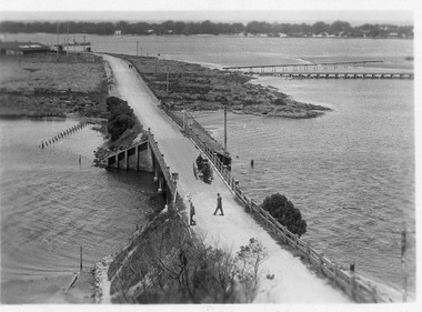
Postcard - North Arm bridge Lakes Entrance Victoria, c1917
... (Club Hotel and Hummocks area cropped from top) also Black and white photographic print 12.5cmx18cm, good condition- 2 copies 'Original T-Beam bridge opened Sept 1917 on reverse P01151-3....(Club Hotel and Hummocks area cropped from top) also Black and white photographic print 12.5cmx18cm, good condition- 2 copies 'Original T-Beam bridge opened Sept 1917 on reverse P01151-3. ...Also sepia toned photographic print 10cmx15cm, good condition old cat No 310 or 318? (Club Hotel and Hummocks area cropped from top) also Black and white photographic print 12.5cmx18cm, good condition- 2 copies 'Original T-Beam bridge opened Sept 1917 on reverse P01151-3.Black and white photographic miniature postcard showing concrete bridge over the North Arm with extended abutments, also shortened bridge length compared to previous bridge, causing restriction of waterway. Two walkers and horse drawn vehicle on bridge. Remaining piles of wooden bridge upstream of bridge, telegraph poles upstream of bridge and across mudflats. Bridge to Bullock Island from mudflat, Club Hotel, Cunninghame Arm, and sand hummocks in distance. Lakes Entrance Victoriabridges, waterways, coast, transport, hotels -
 Yarrawonga and Mulwala Pioneer Museum
Prize certificate Yarrawonga A&P Association, Special certificate Crop Competition, 1957
... Special certificate awarded to J C Thom ad P Bruce Open Wheat crop competition 1957 Area 40 acres. Variety Sherpa Conducted by Yarrawonga and Border Agricultural and Pastoral Society. ...Special certificate awarded to J C Thom ad P Bruce Open Wheat crop competition 1957 Area 40 acres. Variety Sherpa Conducted by Yarrawonga and Border Agricultural and Pastoral Society. ...Crop competitions have been held at local shows dating from late 1800’s to todayCream card Red and Blue print. Hand printed details of winner and description of Crop competition. Also has tractor and plough, silos tractor and header logos on top and wheat head logos on sides and bottom.The Farm Competitions Association of Victoria. Special certificate awarded to J C Thom ad P Bruce Open Wheat crop competition 1957 Area 40 acres. Variety Sherpa Conducted by Yarrawonga and Border Agricultural and Pastoral Society. Signed by Chairman Wm B Miller, Hon Secretary JWC McCann -
 University of Melbourne, Burnley Campus Archives
Plan, Re-organization of apple block, 1980 - 1982
... Plans and lists with row numbers and names. (1) Almonds, quinces, figs, peaches, dated 20.02/81. (2) Crabapples, nectarines, peaches, flowering cherries, feijoas, currants and deciduous trees. Bud stock area - Crops (3) Citrus, plums, apricots, apples, pears, almonds, peaches, figs, quinces, medlars. (4) As for (3) but with amendments. (5) Pear Block....University of Melbourne, Burnley Campus Archives 500 Yarra Boulevard Richmond melbourne orchards Plans and lists with row numbers and names. (1) Almonds, quinces, figs, peaches, dated 20.02/81. (2) Crabapples, nectarines, peaches, flowering cherries, feijoas, currants and deciduous trees. Bud stock area - Crops (3) Citrus, plums, apricots, apples, pears, almonds, peaches, figs, quinces, medlars. (4) As for (3) but with amendments. (5) Pear Block. ...Plans and lists with row numbers and names. (1) Almonds, quinces, figs, peaches, dated 20.02/81. (2) Crabapples, nectarines, peaches, flowering cherries, feijoas, currants and deciduous trees. Bud stock area - Crops (3) Citrus, plums, apricots, apples, pears, almonds, peaches, figs, quinces, medlars. (4) As for (3) but with amendments. (5) Pear Block.orchards -
 Kiewa Valley Historical Society
Cutter Green Feed, Hocking, estimated 1935; Early 20th Century
... areas subjected to limited grass growing seasons. The Kiewa Valley and Alpine regions were up to the 21st century "snowed" in. The conditions requiring summer crops...areas subjected to limited grass growing seasons. The Kiewa Valley and Alpine regions were up to the 21st century "snowed" in. The conditions requiring summer crops ...This iron chaff cutter was a vital piece of rural machinery especial for cattle in areas subjected to limited grass growing seasons. The Kiewa Valley and Alpine regions were up to the 21st century "snowed" in. The conditions requiring summer crops and fodder to be prolonged for the harsh winter climate are now becoming less and less and may confirm the precursor of "global warming". The Kiewa Valley is still a strong base for dairy cattle and other stock requiring all year access to hay/grass supplies. The use of, now defunct, Tobacco drying sheds for the storage of hay and other fodder is typical of the Australian farmer/grazier's adaptability to utilise anything available. To think outside the square.Black Iron Chaff Cutter. The wheel has a single piece inside with 4 curved spokes with adjustable blades attached by 4 screws & 3 rivets. The wheel has a wooden handle. Operated by cogs. HOCKING GREASE BALLARAT COGS FREELYagriculture, farm machinery, stock feeding, grazier, farm animals -
 Kiewa Valley Historical Society
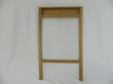
Wash Board Glass, mid 1900s
... Rural areas were the last sectors in Australia where washboards where, through necessity( droughts and lack of domestic water), used up until the late 1900s. This lingering usage was due to the fact that rural properties, on the whole, had water supplies sourced from farm dams and be the ones whose priority feed was targeting crops and farm animals before clothes and other domestic requirements. ...Rural areas were the last sectors in Australia where washboards where, through necessity( droughts and lack of domestic water), used up until the late 1900s. This lingering usage was due to the fact that rural properties, on the whole, had water supplies sourced from farm dams and be the ones whose priority feed was targeting crops and farm animals before clothes and other domestic requirements. ...This washboard is relatively "young" in that the timber has not "aged," however it could have been used by a rural family to wash "delicate" clothing which could not be placed within a large family washing machine or "copper". This type of washboard i.e. glass washboard, was used extensively during the war periods, 1914 to 1918 and 1939 to 1945 when corrugated metal was in scarce supply. Rural areas were the last sectors in Australia where washboards where, through necessity( droughts and lack of domestic water), used up until the late 1900s. This lingering usage was due to the fact that rural properties, on the whole, had water supplies sourced from farm dams and be the ones whose priority feed was targeting crops and farm animals before clothes and other domestic requirements. In the two millennium however, most rural areas are well stocked with water supplies and the very strict edict of conserving water, especially during droughts, of earlier times is not so critical.The Kiewa Valley although well supplied by rivers, streams and artesian water does occasionally through severe drought lack of water for farm domestic washing requirements.This washboard is made of a wooden frame and glass insert (corrugated on one side and smooth on the other). The washboard glass panel is contained within the wooden frame by routered grooves. The frame extends beyond the glass to form two legs below the glass insert and a hand grip above it. This hand grip allows for one hand to hold the washboard firmly upright and one hand to rub clothes vigorously (up and down) against the glass ridges.This action combined with a soap and water based freeing agent loosen any dirt particles which can be rinsed off. The appearance of this washboard is basic but does not detract from its effectiveness. The lack of "wear and tear" on the wooden frame suggest limited use. The construction suggests good workmanship even though there is no manufacturer's logo to be found on it.hand washing, household washing, domestic clothes washing, laundry -
 Kiewa Valley Historical Society
Bible, Bible Moffat, 1935
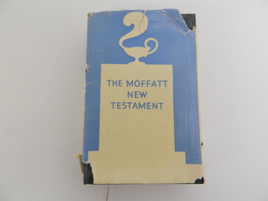
... area were placing hardships which were "foreign" to them, as a family and as a community. The major Christian religions within the Kiewa Valley were either of the Catholic or English Protestant teachings. These groups still remain the dominant ones well into the 2nd Millennium. Spiritual relief to overcome harsh rural setbacks is not just specific to the Australian rural sector but is also global. With the influx of migrant workers from the war torn European nations (after WWII) a broader coverage of Christian and other faiths developed. A "positive" saying, when crops ...This Christian Bible by Professor James Moffatt from the United Free Church College in Glasglow Scotland was at a time when translated Christian bibles(Greek to English) were being review as to the accuracy of their translated words. This period was in the early 1900's specifically during and between the two major World Wars of 1914-18 and 1939-45 and also covering the Great Depression(1939). All these periods were ones of death, destruction and "loss of faith". Bibles which provided greater clarity of better times ahead flourished. This book offered its readers hope for the future (in terrible times). The regions that it covered were those who belonged to the Christian Faith. The significance of this bible to the Kiewa Valley is that it provides an insight of those Christians living in a semi remote rural region at the period in Australian history where forces outside of this area were placing hardships which were "foreign" to them, as a family and as a community. The major Christian religions within the Kiewa Valley were either of the Catholic or English Protestant teachings. These groups still remain the dominant ones well into the 2nd Millennium. Spiritual relief to overcome harsh rural setbacks is not just specific to the Australian rural sector but is also global. With the influx of migrant workers from the war torn European nations (after WWII) a broader coverage of Christian and other faiths developed. A "positive" saying, when crops failed and bush fires and river floods sprang up, rallied the faithful "with God's help" This hard covered bible consists of six pages of preamble including title, publishing details, printer and author's preface. The book has 388 pages of black print. Relevant reference lines are notated by numbers on the left side of the page. On the front dust cover is a cream silhouette against a light blue backdrop highlighting a smoking "Aladdin's" Arabic oil lamp on a cenotaph. The hard cover has a embossed emblem of a lantern with a plume of smoke rising from the spout. This is all encapsulated by a circle. The spine also has this emblem. On the dust jacket, front "THE MOFFATT NEW TESTAMENT", and the back cover has blue writing on a cream background. On the spine, at the top "JAMES MOFFATT" below this a white on blue silhouette of "Alalddin's lamp" below this is (in blue letters against a light blue background " THE NEW TESTAMENT A NEW TRANSLATION" On inside cover a signature "Clare Roper". The hard cover has marked in red print "THE NEW TESTAMENT ANEW TRANSLATION MOFFAT" christian bible, prayer, new testament, religion, faith. -
 Orbost & District Historical Society
poison pot, Smith, R. & E, 1940's
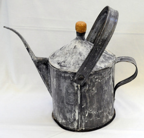
... crop harvesting. The introduction of ‘frill ringing’ and poisoning with arsenical tree killers in the 1940's and 1950's helped reduce the amount of labour required and trees on more country were treated. This enabled the hill country at Bete Bolong to become more productive. The dead trees and shrubs were later cleared by Erle Broome's D7 caterpillar bulldozer. This was the first big area...crop harvesting. The introduction of ‘frill ringing’ and poisoning with arsenical tree killers in the 1940's and 1950's helped reduce the amount of labour required and trees on more country were treated. This enabled the hill country at Bete Bolong to become more productive. The dead trees and shrubs were later cleared by Erle Broome's D7 caterpillar bulldozer. This was the first big area ...This item was used on P.C. Toby Nixon and Grace Nixon's farm, "Rolling Downs" at Bete Bolong. During WW11 the farm grew carrots, red beet, cabbages, beans and maize. Because of labour shortages the government built a Prisoner of War Camp on Russell's Hill. The manager, Dick Northrope, used three Italian prisoners to frill ring small trees and shrubs between crop harvesting. The introduction of ‘frill ringing’ and poisoning with arsenical tree killers in the 1940's and 1950's helped reduce the amount of labour required and trees on more country were treated. This enabled the hill country at Bete Bolong to become more productive. The dead trees and shrubs were later cleared by Erle Broome's D7 caterpillar bulldozer. This was the first big area of 230 acres to be cleared in the Orbost district. Soon after entering World War 11 Australia was asked by Britain to accept and guard large numbers of 'enemy aliens' and prisoners of war. The British government felt that it could not afford to feed large numbers of prisoners and it was believed that once in Australia the internees would have no chance of escape. Eager to show solidarity with Britain's cause, Australia readily agreed and decided to place the prisoners in a number of different camps scattered around the country and guard them with reservists and soldiers too unfit to serve overseas. There was an internment camp at Bete Bolong, Orbost. This item is an example of an item used by the Italian P.O.W.'s residing there. It is also an example of an agricultural tool not commonly used today.A galvanized iron watering can which has been used to hold poison for ring barking trees (possibly arsenic). It has a narrow spout. There is a handle at the back and a folding handle on the top. The top is conical with an opening for a cork. agriculture prisoner-of-war-camp tree-removal land-clearing -
 Eltham District Historical Society Inc
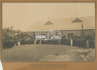
Photograph, Mr John A. Wilson's Hurstbridge Cool Store: The Official Opening by The Lord Mayor of Melbourne, Sir David Hennessy, March 20, 1915, 1915
... area at the beginning of the twenteith century. The state of the art facility was built by private enterprise. Hurstbridge Opening celebration orcharding Sepia photograph mounted on cardboard mount with printed title. Mount 55.9 x 76.0 cm. Photo 38.2 x 60.5 cm. Mount significantly damaged/broken on lower corners and slightly broken off at top left hand corner. Various other damage and chips around perimeter. Digital scan cropped ...Formal photograph taken on the occasion of the official opening. Wilson's private Cool Stores at Hurstbridge comprised six cooling chambers with a refrigeration plant to be used by local growers to store their produce. This photo was found in the Savage family home, formerly the home of Rev. Chase believed to be formerly of Panton Hill or Hurstbridge. (House may have been shifted from Panton Hill - now demolished.) Rev. Chase probably in picture, although not reported as attending in any of the newspaper reports of the day.This photo represents the significance of the orcharding industry in the Hurstbridge and surrounding area at the beginning of the twenteith century. The state of the art facility was built by private enterprise.Sepia photograph mounted on cardboard mount with printed title. Mount 55.9 x 76.0 cm. Photo 38.2 x 60.5 cm. Mount significantly damaged/broken on lower corners and slightly broken off at top left hand corner. Various other damage and chips around perimeter. Digital scan cropped from full size of mounthurstbridge, opening, celebration, orcharding -
 Eltham District Historical Society Inc
Photograph, At Bell Street; from left: Maurie Fabbro, Myra Skipper, Unknown, Arthur Munday, Ian Robertson. Helen Comprione in front
... crop. The site of the Fabbro farm (Diamond Creek side land) is now called Barrack Bushlands. It is doubtful that Fabbro's farm holding was ever called Barrak Park, This title is fairly recent after the Shire of Eltham purchased the land, including the last section in 1993/94. About this time the area...crop. The site of the Fabbro farm (Diamond Creek side land) is now called Barrack Bushlands. It is doubtful that Fabbro's farm holding was ever called Barrak Park, This title is fairly recent after the Shire of Eltham purchased the land, including the last section in 1993/94. About this time the area ...At Bell Street, Fabbro Farm, Eltham; from left: Maurie Fabbro, Myra Skipper, Unknown, Arthur Munday, Ian Robertson. Helen Comprione in front - probably helping to pick a crop. The site of the Fabbro farm (Diamond Creek side land) is now called Barrack Bushlands. It is doubtful that Fabbro's farm holding was ever called Barrak Park, This title is fairly recent after the Shire of Eltham purchased the land, including the last section in 1993/94. About this time the area on the west side of Falkiner Street was purchased by a private developer and developed as housing. The area in Bell Street opposite the Eltham High School was purchased by the State Government is recent years and is called Fabbro Fields. The Fabbro Family operated their farm in Bell Street, Eltham. 1 black and white photographfabbro's farm, guido fabbro, bell street, arhur munday, eltham, helen comprione, ian robertson, maurice fabbro, myra skipper, picking, farming -
 Eltham District Historical Society Inc
Photograph, From left: Unknown, Mario Fabbro and possibly Helen Skipper, Bell Street, Eltham
... crop. The site of the Fabbro farm (Diamond Creek side land) is now called Barrack Bushlands. It is doubtful that Fabbro's farm holding was ever called Barrak Park, This title is fairly recent after the Shire of Eltham purchased the land, including the last section in 1993/94. About this time the area...crop. The site of the Fabbro farm (Diamond Creek side land) is now called Barrack Bushlands. It is doubtful that Fabbro's farm holding was ever called Barrak Park, This title is fairly recent after the Shire of Eltham purchased the land, including the last section in 1993/94. About this time the area ...At Bell Street, Fabbro Farm, Eltham; From left: Unknown, Mario Fabbro and possibly Helen Skipper, standing in the middle of a vegetable crop. The site of the Fabbro farm (Diamond Creek side land) is now called Barrack Bushlands. It is doubtful that Fabbro's farm holding was ever called Barrak Park, This title is fairly recent after the Shire of Eltham purchased the land, including the last section in 1993/94. About this time the area on the west side of Falkiner Street was purchased by a private developer and developed as housing. The area in Bell Street opposite the Eltham High School was purchased by the State Government is recent years and is called Fabbro Fields. The Fabbro Family operated their farm in Bell Street, Eltham. 1 black and white photographfabbro's farm, bell street, eltham, maurice fabbro, farming, helen skipper, vegetables -
 Eltham District Historical Society Inc
Photograph, At Bell Street, Eltham; from left: Helen Skipper, Matcham Skipper, Sonia Skipper and possibly Myra Skipper
... crop. The site of the Fabbro farm (Diamond Creek side land) is now called Barrack Bushlands. It is doubtful that Fabbro's farm holding was ever called Barrak Park, This title is fairly recent after the Shire of Eltham purchased the land, including the last section in 1993/94. About this time the area...crop. The site of the Fabbro farm (Diamond Creek side land) is now called Barrack Bushlands. It is doubtful that Fabbro's farm holding was ever called Barrak Park, This title is fairly recent after the Shire of Eltham purchased the land, including the last section in 1993/94. About this time the area ...At Bell Street, Fabbro Farm, Eltham; From left: Helen Skipper, Matcham Skipper, Sonia Skipper and possibly Myra Skipper, standing in the middle of a vegetable crop. The site of the Fabbro farm (Diamond Creek side land) is now called Barrack Bushlands. It is doubtful that Fabbro's farm holding was ever called Barrak Park, This title is fairly recent after the Shire of Eltham purchased the land, including the last section in 1993/94. About this time the area on the west side of Falkiner Street was purchased by a private developer and developed as housing. The area in Bell Street opposite the Eltham High School was purchased by the State Government is recent years and is called Fabbro Fields. The Fabbro Family operated their farm in Bell Street, Eltham. 1 black and white photographfabbro's farm, bell street, eltham, farming, helen skipper, vegetables, matchcam skipper, myra skipper, sonia skipper -
 Eltham District Historical Society Inc
Photograph, Fabbro's farm, Bell Street, Eltham, c.1990s
... crop of artichokes were planted on the farm at this time. The site of the Fabbro farm (Diamond Creek side land) is now called Barrack Bushlands. It is doubtful that Fabbro's farm holding was ever called Barrak Park, This title is fairly recent after the Shire of Eltham purchased the land, including the last section in 1993/94. About this time the area...crop of artichokes were planted on the farm at this time. The site of the Fabbro farm (Diamond Creek side land) is now called Barrack Bushlands. It is doubtful that Fabbro's farm holding was ever called Barrak Park, This title is fairly recent after the Shire of Eltham purchased the land, including the last section in 1993/94. About this time the area ...Fabbro's farm and house, Bell Street, Eltham, c.1990s. A crop of artichokes were planted on the farm at this time. The site of the Fabbro farm (Diamond Creek side land) is now called Barrack Bushlands. It is doubtful that Fabbro's farm holding was ever called Barrak Park, This title is fairly recent after the Shire of Eltham purchased the land, including the last section in 1993/94. About this time the area on the west side of Falkiner Street was purchased by a private developer and developed as housing. The area in Bell Street opposite the Eltham High School was purchased by the State Government is recent years and is called Fabbro Fields. The Fabbro Family operated their farm in Bell Street, Eltham. 1 colour photograph printed with white borderfabbro's farm, bell street, eltham, artichokes, barak farm -
 Eltham District Historical Society Inc
Photograph, Artichokes growing at Bell Street, Eltham, c.1990s
... crop of artichokes were planted on the farm at this time. The site of the Fabbro farm (Diamond Creek side land) is now called Barrack Bushlands. It is doubtful that Fabbro's farm holding was ever called Barrak Park, This title is fairly recent after the Shire of Eltham purchased the land, including the last section in 1993/94. About this time the area...crop of artichokes were planted on the farm at this time. The site of the Fabbro farm (Diamond Creek side land) is now called Barrack Bushlands. It is doubtful that Fabbro's farm holding was ever called Barrak Park, This title is fairly recent after the Shire of Eltham purchased the land, including the last section in 1993/94. About this time the area ...Fabbro's farm and house, Bell Street, Eltham, c.1990s. A crop of artichokes were planted on the farm at this time. The site of the Fabbro farm (Diamond Creek side land) is now called Barrack Bushlands. It is doubtful that Fabbro's farm holding was ever called Barrak Park, This title is fairly recent after the Shire of Eltham purchased the land, including the last section in 1993/94. About this time the area on the west side of Falkiner Street was purchased by a private developer and developed as housing. The area in Bell Street opposite the Eltham High School was purchased by the State Government is recent years and is called Fabbro Fields. The Fabbro Family operated their farm in Bell Street, Eltham. 1 colour photograph printed with white borderfabbro's farm, bell street, eltham, artichokes, barak farm -
 Eltham District Historical Society Inc
Photograph, Maurice Fabbro with artichokes growing at Bell Street, Eltham, c.1990s. Maurie is in his 70s
... crop of artichokes were planted on the farm at this time. The site of the Fabbro farm (Diamond Creek side land) is now called Barrack Bushlands. It is doubtful that Fabbro's farm holding was ever called Barrak Park, This title is fairly recent after the Shire of Eltham purchased the land, including the last section in 1993/94. About this time the area...crop of artichokes were planted on the farm at this time. The site of the Fabbro farm (Diamond Creek side land) is now called Barrack Bushlands. It is doubtful that Fabbro's farm holding was ever called Barrak Park, This title is fairly recent after the Shire of Eltham purchased the land, including the last section in 1993/94. About this time the area ...Fabbro's farm and house, Bell Street, Eltham, c.1990s. A crop of artichokes were planted on the farm at this time. The site of the Fabbro farm (Diamond Creek side land) is now called Barrack Bushlands. It is doubtful that Fabbro's farm holding was ever called Barrak Park, This title is fairly recent after the Shire of Eltham purchased the land, including the last section in 1993/94. About this time the area on the west side of Falkiner Street was purchased by a private developer and developed as housing. The area in Bell Street opposite the Eltham High School was purchased by the State Government is recent years and is called Fabbro Fields. The Fabbro Family operated their farm in Bell Street, Eltham. 1 colour photograph printed with white borderfabbro's farm, bell street, eltham, artichokes, barak farm, maurice fabbro -
 Bendigo Historical Society Inc.
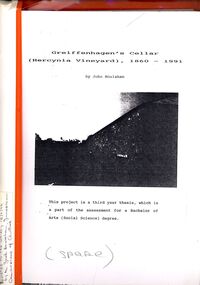
Book - STRAUCH COLLECTION: GREIFFENHAGENS CELLAR (HERCYNIA VINEYARD)
... crops to feed the working horses. In 1870 August sold his interest in the vineyard and set up his own smaller vineyard at Sheepwash Gully. He had several business interests before he took up the caretaker position at the newly dug Weeroona lake, a position he held until his death. Carl Heine sold his interest in the vineyard in 1873 and returned to Germany. WIlliam Grieffenhagen (1834-1916) continued his very successful vineyard until the region was hit with a highly infectious vine disease in 1893. Although his own vines escaped infection, he was within the 2 mile quarantine area...crops to feed the working horses. In 1870 August sold his interest in the vineyard and set up his own smaller vineyard at Sheepwash Gully. He had several business interests before he took up the caretaker position at the newly dug Weeroona lake, a position he held until his death. Carl Heine sold his interest in the vineyard in 1873 and returned to Germany. WIlliam Grieffenhagen (1834-1916) continued his very successful vineyard until the region was hit with a highly infectious vine disease in 1893. Although his own vines escaped infection, he was within the 2 mile quarantine area ..."Hercynia" was the largest vineyyard in the Bendigo District. It was started by Carl Wilhelm Greiffenhagen (William) and his cousins, twins, Carl and August Heine. The first vine cuttings were planted in 1860. The partners owned 300 acres at Axe Creek and in 1862 had 24 acres under vines and an orchard of 4 acres. By 1884 they had expanded to 30 acres of vines. They produced many award winning wines. August Heine ( 1832 - 1898) was born in Germany and came to Australia in 1854 with his twin brother Carl and their cousin William Greiffenhagen. Initially the three took up mining successfully but then the partnership bought 300 acres at Axe Creek and planted a vineyard. They also grew fruit and crops to feed the working horses. In 1870 August sold his interest in the vineyard and set up his own smaller vineyard at Sheepwash Gully. He had several business interests before he took up the caretaker position at the newly dug Weeroona lake, a position he held until his death. Carl Heine sold his interest in the vineyard in 1873 and returned to Germany. WIlliam Grieffenhagen (1834-1916) continued his very successful vineyard until the region was hit with a highly infectious vine disease in 1893. Although his own vines escaped infection, he was within the 2 mile quarantine area and was forced to dig out all his vines. He never replanted but depended on his orchard instead. He was a founding member of the Bendigo Agricultural Society and a local Shire councillor for several years. In 1870 he married Margaret Boyd.Binder containing information relating to Greiffenhagen's cellar (Hercynia Vineyard) 1860 - 1991 including black and white photographs & maps, compiled by John Houlahan as a third year thesis whichnis pat of the assessment for a Bachelor of Arts (Social Science) degree. Donated to the German Society 15/2/96 by the Grandfather of author Jack Houlahan.John Houlahanbook, bendigo, wineries, bendigo-history-axe creek- wineries- german -
 Orbost & District Historical Society
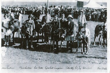
Photograph - Children and their calves at Orbost Show c. 1930
... Orbost is a farming area with dairying and cropping. ...Orbost is a farming area with dairying and cropping. An early photo of children at the Orbost Show. ...This a copy of an original photo supplied by Lachlan Macalister in 2013. The photo is evidence of local children from farms in the Orbost district attending an Orbost Show. The calves are dairy calves and all of the handlers are children. Orbost is a farming area with dairying and cropping. An early photo of children at the Orbost Show.This b/w photo is of a group of children and their calves at the Orbost Show. In the background is a large crowd of people and a tent. Written onto the photo and below the photo are these words: Aenis Leatham, Marie Colson, Penel Yantses, Sylvia Field, George Leatham, Cathie Kelly, Ruby Joy, Walter Webb, Joe Webborbost agricultural show, dairying, children at the show -
 Orbost & District Historical Society
Photograph - Flood, Snowy River, Orbost 1978
... crops and farming, and also to transport. The 1970s was a wet decade with many floods, the largest one in 1971. This photograph was taken in 1978. Evidence of flood on the Snowy River in 1978. floods Snowy River Orbost Written below the photograph: Orbost 1978 A b/w photograph of a flood scene with trees and the river in the front, a river bank, and a vast area of water in the background. ...The Snowy River can flood over its floodplain at Orbost/Newmerella. There have been wet periods when floods were frequent and covered the floodplain, sometimes causing great disruption to crops and farming, and also to transport. The 1970s was a wet decade with many floods, the largest one in 1971. This photograph was taken in 1978. Evidence of flood on the Snowy River in 1978. A b/w photograph of a flood scene with trees and the river in the front, a river bank, and a vast area of water in the background. This photograph has been pasted onto a rough cardboard backing. Written below the photograph: Orbost 1978floods, snowy river, orbost -
 Cheese World Museum
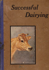
Book, Successfull Dairying in Australia
... It provides information relating to the dairy industry covering topics such as planning, breeding, choosing dairy cattle, feed crops, care of milk and cream and herd health. It covers all areas of Australia. ...It provides information relating to the dairy industry covering topics such as planning, breeding, choosing dairy cattle, feed crops, care of milk and cream and herd health. It covers all areas of Australia. ...This book is part of the collection donated by Leon Garner. It provides information relating to the dairy industry covering topics such as planning, breeding, choosing dairy cattle, feed crops, care of milk and cream and herd health. It covers all areas of Australia. This book is an early manual for Australian dairy farmers.Grey hard cover book with full colour picture of a jersey cow and title printed in black on the front cover. The inside back cover contains a paper lift-up model of a cow showing its skeleton and internal organs.639 (stamped on front page)noel garner, dairy industry, allansford, dairy cattle, cattle breeding, herd health -
 City of Moorabbin Historical Society (Operating the Box Cottage Museum)
Tool - Chinese Market-Gardener's Watering-Cans
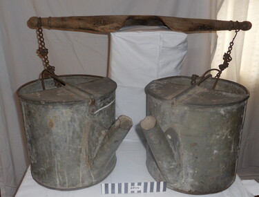
... crops. The cans and yoke alone are very heavy, one can only imagine how heavy they were when filled with water.As profits from the gold-fields petered out the Chinese immigrants, (nearly all single men), were forced to seek other occupations. Many moved into furniture building in the East Melbourne area...crops. The cans and yoke alone are very heavy, one can only imagine how heavy they were when filled with water.As profits from the gold-fields petered out the Chinese immigrants, (nearly all single men), were forced to seek other occupations. Many moved into furniture building in the East Melbourne area ...Chinese market-gardener’s watering-cans on a wooden yoke. This item was authenticated by the Bendigo Historical Society, and is said to be quite rare. It consists of two large galvanized watering-cans each with a pouring spout, suspended by chains from a well-used wooden yoke. The cans would each have been filled with water, then carried a distance into the market garden and used to water crops. The cans and yoke alone are very heavy, one can only imagine how heavy they were when filled with water.As profits from the gold-fields petered out the Chinese immigrants, (nearly all single men), were forced to seek other occupations. Many moved into furniture building in the East Melbourne area, whilst others went into market gardening . A significant number of Chinese men, realising the potential of the sandy, fertile soil, with a good supply of water, in the Shire of Moorabbin, leased tracts of land in that area to establish a market garden and grow produce for the increasing population of MelbourneAfter the Dendy Special Survey in1841in Brighton, Victoria, the first sale of Crown Land, taking in the whole Shire of Moorabbin, occurred in 1852. These allotments of land were eagerly bought up - some by speculators - although many were either worked by the owner, or leased out as market gardens and "fruit gardens", (orchards). Chinese market-gardener’s watering-cans suspended by chains on a wooden yoke. This item was authenticated by the Bendigo Historical Society, and is said to be quite rare. It consists of two large galvanized watering-cans each with a pouring spout, suspended by chains from a well-used wooden yokebrighton, gardeners, bentleigh, orchards, vegetables, dendy henry, market gardens, chinese settlers, pioneers moorabbin, water wells, creeks -
 City of Moorabbin Historical Society (Operating the Box Cottage Museum)
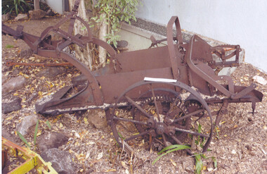
Tool - Farm Machinery, Horse-drawn Plough Potato Digger, c1900
... area of Moorabbin Shire. During the 1850s gold-rush population boom the number of market gardeners increased significantly spreading throughout the Moorabbin Shire. Potatoes were considered a staple foodstuff, so crops ...Circa late 1800s early 1900s a horse-drawn plough, potato digger, is one example of the implements that were widely used by early market gardeners in the Shire of Moorabbin. The flat plate, seen to the right of the photo, dug down into the ground below the potatoes and "scooped" them up. Behind the plate, two driving chains on cogs, (these chains are missing from our exhibit), then "rocked' the dug potatoes to loosen the soil from the "spuds". The potatoes were then harvested by hand. Very large tracts of land in the Shire of Moorabbin were planted with potatoes. Harvesting commenced in October, into November and on into December. Potatoes were a necessary food staple. The market gardeners were always in a rush to be first to get their potatoes to market, and hence the best price. Some market gardeners were so keen to be the first to market, (and get the most money), that they dug their potatoes "green" (or new). The only downside of this practice was that these early potatoes had to be handled with extreme care as their skins were very loose, and came off easily - so decreasing their profits.As well as taking their produce to the Melbourne and St Kilda markets, they also sent produce off to Sydney markets. It is interesting to note that a group of Chinese market gardeners were the first to access the Sydney market. .Following the 'Dendy's Special Survey' 1841 and the Crown Land Sale of 1852, land allotments were sold to pioneer settlers who established market gardens in the area of Moorabbin Shire. During the 1850s gold-rush population boom the number of market gardeners increased significantly spreading throughout the Moorabbin Shire. Potatoes were considered a staple foodstuff, so crops were regularly sown throughout the whole Moorabbin area. Circa late 1800s early 1900s. A horse-drawn plough potato digger is an example of the machines used by early market gardeners in Moorabbin Shiremelbourne, sydney, markets, vegetables, potato, dendy henry, st kilda, market gardeners, gold rush, moorabin, chinese gardeners, ploughs -
 Orbost & District Historical Society
black and white photograph, early 20th century
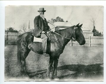
... area. He was a member of the first Orbost Shire Council. His daughter had a fruit & meat shop in McLeod Street. He was an inaugural vestryman of St James Church of England. Edward Pardew was a prominent Orbost citizen in the late 19th / early 20th century. Pardew-Edward A black / white photograph of a bearded man wearing a hat sitting on a horse. He is holding a horse whip. a riding crop ...Edward James Pardew died in 26/9/1927 aged 92. He came to Orbost from New Zealand in 1886 and selected 720 acres of hill land in the Brodribb area. He was a member of the first Orbost Shire Council. His daughter had a fruit & meat shop in McLeod Street. He was an inaugural vestryman of St James Church of England. Edward Pardew was a prominent Orbost citizen in the late 19th / early 20th century.A black / white photograph of a bearded man wearing a hat sitting on a horse. He is holding a horse whip. a riding crop. Behind him is a fenced house.pardew-edward -
 Ringwood and District Historical Society
Photograph, Picking the crop, apple orchard, Ringwood. c1930's
... Crop. Ringwood was famous for its apples. In the early 30s over half of its area was under orchards. ...Crop. Ringwood was famous for its apples. In the early 30s over half of its area was under orchards. ...Black and white photograph (2 copies)Typed under one photograph: Picking the Crop. Ringwood was famous for its apples. In the early 30s over half of its area was under orchards. Written on back of photograph- Leo Pratt and Jack Pratt .agriculture -
 Coal Creek Community Park & Museum
Lancet Horse Flem
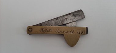
... He was one of the first selectors in the area and the name of his property "Fleetwood" which he took possession of in 1882. He grew potatoes as his main income and was the first farmer to use fertiliser to increase his crops quantity. ...He was one of the first selectors in the area and the name of his property "Fleetwood" which he took possession of in 1882. He grew potatoes as his main income and was the first farmer to use fertiliser to increase his crops quantity. ...This item was the property of Mr Robert Cornall of Kardella. He was one of the first selectors in the area and the name of his property "Fleetwood" which he took possession of in 1882. He grew potatoes as his main income and was the first farmer to use fertiliser to increase his crops quantity. He died in 1924 and is buried in the Korumburra cemetery. This item is engraved with his name and name of his property. The lancet was sold by Sears and Roebuck and is seen in the 1902 catalogue. Made of brass and steel and manufactured by Joseph Rodgers and sons. The item is called a lancet but is also known as Horse Flem and was used for bleeding horses to remove bad blood. This object is of historic and scientific importance as it was used by a local potato farmer, Robert Cornall of Kardella as a bleeding tool for his horses. When purchased this item would not have been engraved. This item is engraved with the name Robert Cornell 1886 and reverse Fleetwood Gippsland Korumburra. Fleetwood was the name of his property which he settled in 1882.Bleeding of horses during this period was a way of removing bad blood.lancet -
 Ballarat Tramway Museum
Photograph - Black & White Photograph/s, John Webster, 21/08/1955 12:00:00 AM
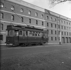
... cropping marks on the rear. Black and white photograph of Geelong No. 19 with the background of the wool store area. ...Yields information about the appearance of one Geelong's single truck trams and its wool store environment.Black and white photograph of Geelong No. 19 with the background of the wool store area. Tram has the destination of Chilwell. Photographed by John Webster, 21/8/1955. Photo used on page 43 of Destination Eaglehawk. Actual print is part of the whole negative. See image 4210i3 On Negative in ink "EH 33" Negative scanned at hi res 4/6/2020 and image updated. ink on rear "Tram 19 Geelong Vic. W. John Webster Photo". On top edge "9263#" and EH33 21-8-55 and initials JR. In pencil is the instruction, increase to 31ems and pencil cropping marks on the rear.tramways, trams, geelong, tram 19