Showing 10 items matching "dalton's flat"
-
 Federation University Historical Collection
Booklet - Exercise Book, Sebastopol Mines and Socialism
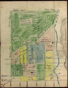
... ...dalton's flat...Barker Library (top floor) Mount Helen goldfields Sebastopol is a suburb of Ballarat. william robertson new lady don company kohinor company leviathon company newington copenhagen company hand in hand company tannery ground ballarat freehold company rough and ready company park company inkerman alluvial lead band & albion consols gravel pits lead robert gay sebastopol mines ballarat east alluvial dalton's flat canadian gully red streak montezuma company great republic company golden point gravel pits j. hardy scott's boot shop lady don company cgt Handwritten pages .1) Black notebook with red spine .2) hand drawn map showing location of Sebastopol mines Sebastopol Mines and Socialism Booklet Exercise Book William Robertson ...Sebastopol is a suburb of Ballarat..1) Black notebook with red spine .2) hand drawn map showing location of Sebastopol minesHandwritten pageswilliam robertson, new lady don company, kohinor company, leviathon company, newington, copenhagen company, hand in hand company, tannery ground, ballarat freehold company, rough and ready company, park company, inkerman alluvial lead, band & albion consols, gravel pits lead, robert gay, sebastopol mines, ballarat east, alluvial, dalton's flat, canadian gully, red streak, montezuma company, great republic company, golden point, gravel pits, j. hardy, scott's boot shop, lady don company, cgt -
 Federation University Historical Collection
Book, Albert J. Mullett, List of Nuggets found in Victoria, 1912
... ...Dalton's Flat...Barker Library (top floor) Mount Helen goldfields geological survey of victoria gold nuggets e.j. dunn w. dickson peter mcbride a. e. smith tinworth's party Welcome stranger Ah chung Dalton's Flat lady hotham Lady Don Lady Barkly Needful Corinella Mining CO W. ...Pink soft covered foolscap book of 67 pages listing the gold nuggets found in Victoria. The Book is no 12 in the 'Memoirs of the Geological Survey of Victoria' series. The listing of nuggets found in Victoria includes number of nugget, whether found in quartz or alluvial, weight, where found, depth, name of nugget. date found, finders, authority and remarks. 1360 nuggets weighing over 20 ozs are listed.geological survey of victoria, gold nuggets, e.j. dunn, w. dickson, peter mcbride, a. e. smith, tinworth's party, welcome stranger, ah chung, dalton's flat, lady hotham, lady don, lady barkly, needful, corinella mining co, w. kitt, p. flood, celeste lafranchi, bravo, w. passobi, mrs rowlands -
 Federation University Historical Collection
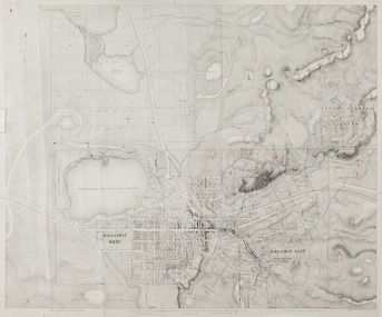
Map, Ballaarat Gold Field, 1861, 1861
... ...Dalton's Flat...In November 2004 the Central Highlands Regional Library presented a special edition of 200 copies of the 1861 map reproduced from a copy in their collection. ballarat map ballarat east lake wendouree survey mines robert davidson ballarat gold field 1861 yuille's swamp wendouree swamp little bendigo diggings gold leads old post office hill specimen hill bakery hill black hill dead horse creek brown hill pennyweight hill clayton hill soldiers hill golden point gum tree flat white flat poverty hill chinese village robert brough smyth Ballarat map 1861 Ballaarat Vineyard Dead Horse Gully Deadhorse Creek Invermay Black Hill Flat Gaelic Church Police Reserve Magpie Range Dalton's Flat Caadian Lead Rifle Butts Powder Magazine Bathing House Government Camp Gold Office Chinese Llanberrris Victoria Theatre Charlie Napier Hotel United States Hotel Grape's Hoel Clayton's Hill Cattleyard Hill Free Trade Hotel Esmond Lead Bakery Hill Black Hill Lead Juvenile Reformatory Ballarat Orphanage Lady Barkly Lead Triffet's Slaughter Yard Little Bendigo Melbourne Road T. ...A party of surveyors camped by Yuille's Swamp (later Lake Wendouree) and surveyed the countryside for a map to be produced by the Geological Survey of Victoria. In November 2004 the Central Highlands Regional Library presented a special edition of 200 copies of the 1861 map reproduced from a copy in their collection. Original 1861 map of Ballarat showing streets and leads. Blue dots indicate gold leads, and red lines indicate auriferous quartz reef and outcrops of quartz veins."Compiled & Drawn from the Survey of Mining Surveyors Davidson, Fitzpatrick and Cowan & the Plans in the Surveyor General's Office by J. Brahe, 21st October 1861. R. Brough Smyth, Secretary for Mines. The Honourable J.B. Humffray, M.L.A. Commr of Mines.”ballarat, map, ballarat east, lake wendouree, survey, mines, robert davidson, ballarat gold field 1861, yuille's swamp, wendouree swamp, little bendigo diggings, gold leads, old post office hill, specimen hill, bakery hill, black hill, dead horse creek, brown hill, pennyweight hill, clayton hill, soldiers hill, golden point, gum tree flat, white flat, poverty hill, chinese village, robert brough smyth, ballarat map 1861, ballaarat vineyard, dead horse gully, deadhorse creek, invermay, black hill flat, gaelic church, police reserve, magpie range, dalton's flat, caadian lead, rifle butts, powder magazine, bathing house, government camp, gold office, chinese, llanberrris, victoria theatre, charlie napier hotel, united states hotel, grape's hoel, clayton's hill, cattleyard hill, free trade hotel, esmond lead, bakery hill, black hill lead, juvenile reformatory, ballarat orphanage, lady barkly lead, triffet's slaughter yard, little bendigo, melbourne road, t. cowan, thomas cowan -
 Federation University Historical Collection
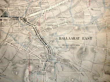
Map, Ballaarat Gold Field, 1861, 21/10/1861
... ...dalton's flat...In November 2004 the Central Highlands Regional Library presented a special edition of 200 copies of the 1861 map reproduced from a copy in their collection. ballarat map davidson robert brough-smyth fitzpatrick cowan yuille's swamp public garden reserve manure depot black hill ballarat east old post office hill pennyweight hill claytons hill golden point mining railway cricket ground swamp creek cemetery sludge reserve bakery hill gaelic church juvenile reformatory orphanage specimen hill eureka lead cattle yard hill dalton's flat chinese village poverty hill railway reserve little bendigo diggings pound reserve allied armies flour mill agricultural reserve marsh survey reserve survey corps white flat yarrowee yarrowee creek brache j. brache survey ballaarat gold field 1861 Compiled & Drawn from the Survey of Mining Surveyors Davidson, Fitzpatrick and Cowan & the Plans in the Surveyor General's Office by J. ...A party of surveyors camped by Yuille's Swamp (later Lake Wendouree) and surveyed the countryside for a map to be produced by the Geological Survey of Victoria. In November 2004 the Central Highlands Regional Library presented a special edition of 200 copies of the 1861 map reproduced from a copy in their collection. Original geological map of Ballarat showing property, waterways, mines, churches, schools, water races, and garden reserves. It was compiled and drawn from the surveys of Mining Surveyors Davidson, Fitzpatrick and Cowan.Compiled & Drawn from the Survey of Mining Surveyors Davidson, Fitzpatrick and Cowan & the Plans in the Surveyor General's Office by J. Brahe, 21st October 1861. R. Brough Smyth, Secretary for Mines. The Honourable J.B. Humffray, M.L.A. Commr of Mines.ballarat, map, davidson, robert brough-smyth, fitzpatrick, cowan, yuille's swamp, public garden reserve, manure depot, black hill, ballarat east, old post office hill, pennyweight hill, claytons hill, golden point, mining, railway, cricket ground, swamp creek, cemetery, sludge reserve, bakery hill, gaelic church, juvenile reformatory, orphanage, specimen hill, eureka lead, cattle yard hill, dalton's flat, chinese village, poverty hill, railway reserve, little bendigo diggings, pound reserve, allied armies, flour mill, agricultural reserve, marsh, survey reserve, survey corps, white flat, yarrowee, yarrowee creek, brache, j. brache, survey, ballaarat gold field 1861 -
 Eltham District Historical Society Inc
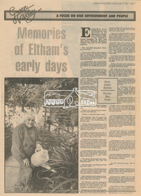
Newsclipping, Linley Hartley, Memories of Eltham's early days by Linley Hartley; picture by Ron Grant, Diamond Valley News, 13 August 1985, p37, 13 Aug 1985
... Flat...buses...butcher...Cheddar Black...Clarrie White...Collis...Dalton...Eltham District Historical Society Inc 728 Main Rd Eltham melbourne Memories of Mrs Irene "Rennie" Harrison 1939 bushfire Alf Isherwood Annie Bremmer Arthur Munday Beryl Bradbury (nee Stokes) Collection Bible Street Bremmer's Flat buses butcher Cheddar Black Clarrie White Collis Dalton Street Eltham Hotel Eltham Kindergaten Eltham Lower Park Eltham Primary School Eltham Railway Station Eltham South Kindergarten eltham tea rooms Farmer Walsh franklin street freddie griffiths greengrocer Grocers Eltham Infant Welfare Centre Irene Rennie Harrison jack carrucan josie shannon Justus Jorgensen Len Harrison Main Road Markets Matcham skipper Metery Road Milk Bar Montsalvalt Mount Pleasant road Shirley Harrison St Margaret's church hall Wingrove Park reminscences Digital file only - Digitised by EDHS from a scrapbook on loan from Beryl Bradbury (nee Stokes), daughter of Frank Stokes. ...Memories of Mrs Irene "Rennie" HarrisonDigital file only - Digitised by EDHS from a scrapbook on loan from Beryl Bradbury (nee Stokes), daughter of Frank Stokes.1939 bushfire, alf isherwood, annie bremmer, arthur munday, beryl bradbury (nee stokes) collection, bible street, bremmer's flat, buses, butcher, cheddar black, clarrie white, collis, dalton street, eltham hotel, eltham kindergaten, eltham lower park, eltham primary school, eltham railway station, eltham south kindergarten, eltham tea rooms, farmer walsh, franklin street, freddie griffiths, greengrocer, grocers, eltham infant welfare centre, irene rennie harrison, jack carrucan, josie shannon, justus jorgensen, len harrison, main road, markets, matcham skipper, metery road, milk bar, montsalvalt, mount pleasant road, shirley harrison, st margaret's church hall, wingrove park, reminscences -
 Eltham District Historical Society Inc
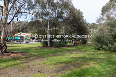
Photograph, Peter Pidgeon, Site of former Eltham Tennis Court, Wingrove Park, 2 Aug. 2022
... Dalton Street adjacent to the Jarrold family cottage. He never married and continued his profession as a bootmaker from this little shop, maintaining a close relationship with Mrs Jarrold for the rest of their lives. His bootmaker shop remains today beside the Whitecloud cottage and is one of only three remaining shops in the area from the early 20th century. Comparative photo taken 2022 with one taken from same location over 100 years earlier by noted local photographer J.H. Clark Bible Street Eltham J.H. Clark Photo (2022) Bremner's Flat ...View looking through Wingrove Park from near the Diamond Creek Trail towards the Coles Express Service Station and Mount Pleasant Road intersection. Comparison photo: SEPP_0720 Eltham Tennis Court, c.1909 and SEPP_0721 - Eltham Tennis Court, Lady Premiers 1909-1910 The tennis courts were located in Bremner’s Flats, present day Wingrove Park. The Eltham Lawn Tennis Club was formed on a Saturday evening, the 29th of October, 1898 at a meeting held at the Eltham State school. Twenty members were enrolled, and eight more shortly afterwards. Officers and a committee were duly elected, and the Treasurer was instructed to purchase the necessary requisites without delay. By the end of the first week in November all the requisites were to hand, two courts were marked out, and practice begun. The formal opening of the Courts of this Club took place on Saturday, November 12, 1898, when 26 members and their friends assembled. Part of a presentation by Peter Pidgeon to the Society, 13 August 2022 showcasing a series of photographs taken by John Henry Clark over the period 1895 to 1930. John Henry Clark was the youngest of three boys born to William Henry Clark (1823-1877) and Maria White (1843-1914). He and his brothers, William Charles Clark (1872-1945), Clement Kent Clark (1874-1912) operated a photography business (Clark Bros.) from 25 Thomas Street, Windsor near Prahran during the period c.1894 to 1914. Following death of Clement in September 1912 and their mother in 1914, the Clark Bros business appears to have dissolved, the premises demolished, and a new house was under construction in 1915. John set up business independently in 1914 operating out of 29 Moor Street, Fitzroy where he is registered in the 1914 and 1915 Electoral Rolls. By 1916 John had relocated to Eltham where he continued his practice as a photographer and took many of the early images around the district of Little Eltham. Around 1930 John changed professions and opened a small cobbler's shop in 1931 near the pond opposite Dalton Street adjacent to the Jarrold family cottage. He never married and continued his profession as a bootmaker from this little shop, maintaining a close relationship with Mrs Jarrold for the rest of their lives. His bootmaker shop remains today beside the Whitecloud cottage and is one of only three remaining shops in the area from the early 20th century.Comparative photo taken 2022 with one taken from same location over 100 years earlier by noted local photographer J.H. ClarkBorn Digitalbible street, eltham, j.h. clark photo (2022), bremner's flat, eltham lawn tennis club, eltham tennis court, main road, mount pleasant road, tennis court, wingrove park -
 Eltham District Historical Society Inc
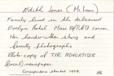
Document - Folder, McLean, 1984-1999
... Flat...Burgoyne's Shop...Cable Tram...Cemetery Road...Centenary Celebrations...Centenary Parade...Christening...Coach House...Collis Grocery...Dalton...Retrieved June 20, 2022, from http://nla.gov.au/nla.news-article56747552 1934 Flood Ballroom Baptism Barber shop Bittern Boy Scouts Bremner's Flat Burgoyne's Shop Cable Tram Cemetery Road Centenary Celebrations Centenary Parade Christening Coach House Collis Grocery Dalton Street depression Dole Dorothy Jean McLean Edith Jones (nee McLean) eltham fire brigade Eltham High School Eltham Higher Elementary School Eltham Lower Park Eltham Railway Station Eltham State School No. 209 Evelyn Hotel Fire Damage - Buildings Flinders Naval Depot Fordham Gladys Evelyn Mclean Gold mining Gwenneth Mae McLean Gwladys Evelyn McLean Headmistress Hector John McLean Isherwood House and shop Louisa Frances McLean (nee Green) Metery Road Methodist Church Miss Finnin Miss Grant cottage Motor bike races Mrs Barrett Mrs Bremner Mrs Hurley Olive Isabel Mclean Parade Phoebe Lillian Mclean Picnic Pioneers of Eltham Pitt Street Research Fire Brigade Rev. ...References to McLean family, Hector John McLean and Louisa Frances (nee Green) and six daughters who lived in Eltham during the period 1930 to 1934 inclusive. Lived in the former Evelyn Hotel at the time it was destroyed by fire and being part of the Centenary Parade in 1934 where the family won the Group Section for their entry “Pioneers of Eltham” Reminiscences provided by Edith Jones (nee M1934 flood, ballroom, baptism, barber shop, bittern, boy scouts, bremner's flat, burgoyne's shop, cable tram, cemetery road, centenary celebrations, centenary parade, christening, coach house, collis grocery, dalton street, depression, dole, dorothy jean mclean, edith jones (nee mclean), eltham fire brigade, eltham high school, eltham higher elementary school, eltham lower park, eltham railway station, eltham state school no. 209, evelyn hotel, fire damage - buildings, flinders naval depot, fordham, gladys evelyn mclean, gold mining, gwenneth mae mclean, gwladys evelyn mclean, headmistress, hector john mclean, isherwood house and shop, louisa frances mclean (nee green), metery road, methodist church, miss finnin, miss grant cottage, motor bike races, mrs barrett, mrs bremner, mrs hurley, olive isabel mclean, parade, phoebe lillian mclean, picnic, pioneers of eltham, pitt street, research fire brigade, rev. r.g. arthur, shed, shops, st margarets church hall, st margaret's church, stables, state savings bank of victoria, susso books, todaro, vinnie willet, warrandyte bridge, warrandyte, wingrove park, yarra river -
 Eltham District Historical Society Inc
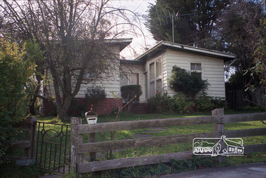
Photograph, Margaret Ball, 33 Dudley Street, Eltham, June 1999, 1999
... flat. The Margaret Ball (Pre 1960s Houses) Collection was a personal project initiated to mark the year 2000 and arose as a result of the disappearance of many pre-1960s parts of Eltham due to development. Approximately 200 pre-1960s style houses that were left in Eltham between Main Road and east to Bible Street, between Cecil Street to the north and south to Dalton Street were photographed in late 1999. ...Owner 1960s: Smith. Eliza Beale and Miss Taylor were occupiers of the flat.The Margaret Ball (Pre 1960s Houses) Collection was a personal project initiated to mark the year 2000 and arose as a result of the disappearance of many pre-1960s parts of Eltham due to development. Approximately 200 pre-1960s style houses that were left in Eltham between Main Road and east to Bible Street, between Cecil Street to the north and south to Dalton Street were photographed in late 1999. Not all of the houses could be photographed; some because the garden or trees blocked the view of the house, others because of rubbish or cars were in the way, some because people were working on the house or in the gardens at the time.Roll of 35mm colour negative film, 5 of 6 stripsFuji 200eltham, houses, streets, margaret ball (pre 1960s houses) collection, dudley street -
 National Wool Museum
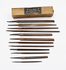
Tool - Metal Files, c. 1920
... Dalton who was the foreman of the building for 34 years. Files are ‘Cup Brand’ – ‘Best refined steel files’ and were manufactured by the no longer trading Moss & Gamble Brothers LTD at the Franklin works in Sheffield, England. stencils denny’s lascelles bow truss building 12 steel files of varying length, thickness and shape. The longest and thickets are in a flat ...Selection of metal files used for cutting wool bale stencils with an accompanying box. Not all files belong to this box as some are too long to fit within. Used in Denny’s Lascelles Bow Truss building by Maurice Dalton who was the foreman of the building for 34 years. Files are ‘Cup Brand’ – ‘Best refined steel files’ and were manufactured by the no longer trading Moss & Gamble Brothers LTD at the Franklin works in Sheffield, England.12 steel files of varying length, thickness and shape. The longest and thickets are in a flat half circle with some files being fully flat, others complete cylinders, one is a complete square and others are in the shape of a triangle. Cardboard box is brown with black inscription on lid of box.stencils, denny’s lascelles bow truss building -
 National Wool Museum
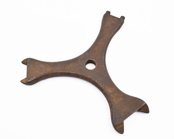
Cog Spanner, 1900-1980
... Dalton who was the foreman of the show floor of the Dennys Lascelles building until his retirement after 34 years at the company. Maurice used the cog spanner in his work as a wool classer in rural Victoria and New South Wales. Inscription. Lettering: LISTER Three prong spanner, two prong look like spanners while the third has two small metal prongs extending from flat ...Cog spanner used for maintenance on a sheering hand piece. This particular spanner belong to Maurice Dalton who was the foreman of the show floor of the Dennys Lascelles building until his retirement after 34 years at the company. Maurice used the cog spanner in his work as a wool classer in rural Victoria and New South Wales.Three prong spanner, two prong look like spanners while the third has two small metal prongs extending from flat metal arm edge. Hole is present in the middle where the three prongs meetInscription. Lettering: LISTER