Showing 7 items matching "dargo high plains"
-
 Federation University Historical Collection
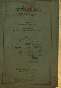
Book, Mines Department, Victoria, Deep Leads of Victoria, 1937, 1937
... ...dargo high plains...Contents include Ballarat, berry Consols, Canadian Lead, Castlemaine-Daylesford System, Chiltern, Duke of Cornwall Mine, Dyke's Freehold, Frenchman's Lead, Garibaldi Shaft, Glenfine, Guidlford, Hepburn Estate Co., Hepburn Home Paddock, Italian Gully, Henderson's Lead, Langi Logan, Leigh Consols, Sebastopol Plateau; Talbot, Woady Yalloak, A definition of a deep lead, formation of deep leads, water in deep leads, methods of deep lead mining (Tunnelling, Deep sinking, Chiltern method of working, Ballarat method of working), sampling washdirt and gravels, Balmoral, Mt William, Stawell, Moyston, Great Western, Ararat, Raglan, Wimmera Valley, Landsborough, Cardigan, Haddon, Beaufort, Waterloo, Avoca, Lamplough, Caralulup, Ballarat West, Ballarat, Smythesdale, Glenfine, Illabarook, Durham Lead, Morrison's Lead, Bullengarook, Berry-Moolort-Loddon System, Clunes, Creswick, Spring Hill, Bullarook, Castlemaine - Daylesford, Majorca, Carisbrook, Timor, Burnt Creek Tributary, Tarnagulla, Marong, Rheola, Inglewood, Huntly, Coliban, Campaspe, Goulburn Lead System, Ovens Valley System, Mitta Mitts, Kiewa Valley, Tarago, Tanjil, Moondarra, Bogong, Dargo High Plains, glossary...Barker Library (top floor) Mount Helen goldfields mining deep leads mines department squire leigh consols chiltern duke of cornwall mine dyke's freehold frenchman's lead garibaldi shaft glenfine guidlford hepburn estate co. hepburn home paddock italian gully henderson's lead langi logan sebastopol plateau talbot woady yalloak tunnelling deep sinking chiltern method of working ballarat method of working sampling washdirt. gravels balmoral mt william stawell moyston great western ararat raglan wimmera valley landsborough cardigan haddon beaufort waterloo avoca lamplough caralulup ballarat west ballarat smythesdale illabarook durham lead morrison's lead bullengarook berry-moolort-loddon system clunes creswick spring hill bullarook castlemaine - daylesford majorca carisbrook timor burnt creek tributary tarnagulla marong rheola inglewood huntly coliban campaspe goulburn lead system ovens valley system mitta mitta kiewa valley tarago tanjil moondarra bogong dargo high plains Charcoal green soft covered book of 64 pages. ...Charcoal green soft covered book of 64 pages. Contents include Ballarat, berry Consols, Canadian Lead, Castlemaine-Daylesford System, Chiltern, Duke of Cornwall Mine, Dyke's Freehold, Frenchman's Lead, Garibaldi Shaft, Glenfine, Guidlford, Hepburn Estate Co., Hepburn Home Paddock, Italian Gully, Henderson's Lead, Langi Logan, Leigh Consols, Sebastopol Plateau; Talbot, Woady Yalloak, A definition of a deep lead, formation of deep leads, water in deep leads, methods of deep lead mining (Tunnelling, Deep sinking, Chiltern method of working, Ballarat method of working), sampling washdirt and gravels, Balmoral, Mt William, Stawell, Moyston, Great Western, Ararat, Raglan, Wimmera Valley, Landsborough, Cardigan, Haddon, Beaufort, Waterloo, Avoca, Lamplough, Caralulup, Ballarat West, Ballarat, Smythesdale, Glenfine, Illabarook, Durham Lead, Morrison's Lead, Bullengarook, Berry-Moolort-Loddon System, Clunes, Creswick, Spring Hill, Bullarook, Castlemaine - Daylesford, Majorca, Carisbrook, Timor, Burnt Creek Tributary, Tarnagulla, Marong, Rheola, Inglewood, Huntly, Coliban, Campaspe, Goulburn Lead System, Ovens Valley System, Mitta Mitts, Kiewa Valley, Tarago, Tanjil, Moondarra, Bogong, Dargo High Plains, glossarymining, deep leads, mines department, squire, leigh consols, chiltern, duke of cornwall mine, dyke's freehold, frenchman's lead, garibaldi shaft, glenfine, guidlford, hepburn estate co., hepburn home paddock, italian gully, henderson's lead, langi logan, sebastopol plateau, talbot, woady yalloak, tunnelling, deep sinking, chiltern method of working, ballarat method of working, sampling washdirt. gravels, balmoral, mt william, stawell, moyston, great western, ararat, raglan, wimmera valley, landsborough, cardigan, haddon, beaufort, waterloo, avoca, lamplough, caralulup, ballarat west, ballarat, smythesdale, illabarook, durham lead, morrison's lead, bullengarook, berry-moolort-loddon system, clunes, creswick, spring hill, bullarook, castlemaine - daylesford, majorca, carisbrook, timor, burnt creek tributary, tarnagulla, marong, rheola, inglewood, huntly, coliban, campaspe, goulburn lead system, ovens valley system, mitta mitta, kiewa valley, tarago, tanjil, moondarra, bogong, dargo high plains -
 Federation University Historical Collection
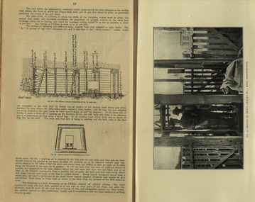
Book, Stanley B. Hunter, Memoirs of the Geological Survey of Victoria No 7., The Deep Leads of Victoria, 1909
... ...dargo high plains...Barker Library (top floor) Mount Helen goldfields mining deep leads squire tools gold panning gold cradle cradling puddling tubbing mining shaft shaft sinking whip horse whip whim horse whim chalk's no. 1 mine, maryborough mining cage shaft mining trucks maryborough washdirt puddler tunnelling deep sinking chiltern method of working ballarat method of working sampling washdirt. gravels balmoral mt william stawell moyston great western ararat raglan wimmera valley landsborough cardigan haddon beaufort waterloo avoca lamplough caralulup ballarat west ballarat smythesdale glenfine illabarook durham lead morrison's lead bullengarook berry-moolort-loddon system clunes creswick spring hill bullarook castlemaine - daylesford majorca carisbrook timor burnt creek tributary tarnagulla marong rheola inglewood huntly coliban campaspe goulburn lead system ovens valley system mitta mitta kiewa valley tarago tanjil moondarra bogong dargo high plains Pink paper covered book by Stanley Hunter, Engineer in Charge of Boring Operations. ...Pink paper covered book by Stanley Hunter, Engineer in Charge of Boring Operations. Contents include tunnelling, deep sinking, the Chiltern Method, the Ballarat Method, Stawell, Ararat, Moyston, Raglan, Wimmera, Landsborough, Avoca, Ballarat West Leads, Berry-Moolort-Loddon Lead System, Clunes, Creswick, Bullarook Affluent, Corinella, Daylesford-Castlemaine Tributary, Majorca-Carisbrook tributary, Huntly, Coliban, Campaspe, Rutherglen., Smythesdale, Durham Lead, Tanjil, Evolution of Mining Machinery, size of claims, Definition of a Deep Lead, Discovery of Gold in Victoria, Geographical Position of Deep Leads, Water in Deep Leads, Methods of Deep Lead Mining, Cost of Deep Lead Mining, Stawell, Ararat, Moyston, Raglan, Wimmera, Landsborough, Avoca, Ballarat West, Berry, Springs Hill, Loddon Valley, Charlotte Plains, , Timor, Burn Creek, Huntly, Colinan, Goulburn, Ovens Valley, Chiltern, Indigo, Morrison's Lead, Plans include: geological Map of Stawell, ararat, Raglan and Landsborough; Kempson's Freehold Mine, Stawell; Geological Map of Beaufort, Avoca, Maryborough, Ballarat west, Berry-Moolort, Loddon, Creswick, Marong, &c; Cardigan Propriety Gold Mine; Working Miners United Gold Mine, Homebush; Hepburn Deep Lead Plan; Madame Berry West Mine; West Berry Consols Mine; Spring Hill and Central Leads; Berry Consols Extended Mine; Loddon Valley Goldfields; Chalk's No 3 Mine; Charlotte Plains Considated Mine; Duke United Mine; Geological Map of Bendigo, Huntley, Campaspe, Malmsbury, Kyneton, trentham, &c; Geological Map of Chiltern, Rutherglan, Eldorado, Beechworth, &c; Chiltern Valley Gold Mine; Wallace Chiltern Valley Consols Mine; great Southern and Chiltern Valley United Mine; great Northern extended Consols; Prentice and Southern deep Leads; Glenfine South Gold Mine; Geological map of Pitfield, Rokewood, Mt Mercer, Ballark, Meredith, &c.; McEvoy Mine; Dargo . . . . . . . . . . . . . . . . . . . . . . . mining, deep leads, squire, tools, gold panning, gold cradle, cradling, puddling, tubbing, mining shaft, shaft sinking, whip, horse whip, whim, horse whim, chalk's no. 1 mine, maryborough, mining cage, shaft, mining trucks, maryborough, washdirt, puddler, tunnelling, deep sinking, chiltern method of working, ballarat method of working, sampling washdirt. gravels, balmoral, mt william, stawell, moyston, great western, ararat, raglan, wimmera valley, landsborough, cardigan, haddon, beaufort, waterloo, avoca, lamplough, caralulup, ballarat west, ballarat, smythesdale, glenfine, illabarook, durham lead, morrison's lead, bullengarook, berry-moolort-loddon system, clunes, creswick, spring hill, bullarook, castlemaine - daylesford, majorca, carisbrook, timor, burnt creek tributary, tarnagulla, marong, rheola, inglewood, huntly, coliban, campaspe, goulburn lead system, ovens valley system, mitta mitta, kiewa valley, tarago, tanjil, moondarra, bogong, dargo high plains -
 Lakes Entrance Historical Society
Book, North East Regional Tourist Authority, North East Victoria, 1980
... A brief record of the region from the Murray River in the north to the Dargo High Plains in the south, from Yarrawonga and Wangaratta in the west to the Indi River in the east. ...Lakes Entrance Historical Society 4 Marine Parade Lakes Entrance gippsland Tourism Mines and Mining Settlers Water supply A brief record of the region from the Murray River in the north to the Dargo High Plains in the south, from Yarrawonga and Wangaratta in the west to the Indi River in the east. ...A brief record of the region from the Murray River in the north to the Dargo High Plains in the south, from Yarrawonga and Wangaratta in the west to the Indi River in the east. Illustrated with coloured photographs.tourism, mines and mining, settlers, water supply -
 Lakes Entrance Historical Society
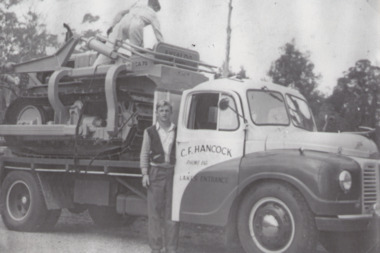
Photograph - Hancock Trucking, Jack Corbett and Ted Jackel, c1950
... Black and white photograph of Jack Corbett and Ted Jackel with Hancock's Austin truck, loaded with bulldozer being transported for Jack Treasure of Dargo High Plains. Taken during a stop at Stratford Victoria...Businesses People Transport Black and white photograph of Jack Corbett and Ted Jackel with Hancock's Austin truck, loaded with bulldozer being transported for Jack Treasure of Dargo High Plains. Taken during a stop at Stratford Victoria Jack Corbett and Ted Jackel Photograph Hancock Trucking ...Black and white photograph of Jack Corbett and Ted Jackel with Hancock's Austin truck, loaded with bulldozer being transported for Jack Treasure of Dargo High Plains. Taken during a stop at Stratford Victoriabusinesses, people, transport -
 Kiewa Valley Historical Society
Maps - Bogong x2, Tawonga, Omeo, Dargo, Victoria and others, 1. Bogong Alpine Area; 2. Bogong 8324; 3. Tawonga Topographical; 4. Omeo 8433; 5. Dargo 8323; 6. Victoria State
... Kiewa Valley Historical Society Mount Beauty Information Centre 31 Bogong High Plains Rd Mt Beauty high-country maps bogong omeo tawonga dargo victoria bogong alpine area An inscription handwritten in blue pen "Trappers Gap to Mitta Mitta 1" to 1 mile". ...1. Bogong Alpine Area (outdoor Leisure Map. survey & Mapping Victoria, Government of Victoria, Edition 2, reprinted 1991 with an image of Mt. Feathertop on the front. Information for tourist in the Alpine National Park: Bogong Area. Including: recreational activities, history, weather and vegetation and a list of walks together with locality maps and photographs. The front cover has an image of Mt Feathertop against a blue sky with yellow writing 'Bogong Alpine Area', there is a yellow triangular block on the right hand top corner with black writing 'Outdoor Leisure Map. On the bottom edge is a block of yellow with black writing 'Survey & Mapping Victoria' and a light green map of Victoria with 'VICMSP' printed in white. 2. 8324 Bogong Victoria, Edition 1, Commonwealth of Australia 1981. A topographical Map: 1:100,000 scale (1 cm to 1 KM). Map has a red cover with white writing together with a white block and black writing and a map insert. 3. Tawonga Topographical Map - Forests Commission Victoria, / revised 5/9/77, DEG No. 68-G/399. A Tawonga 803 folded map in a beige colour with the back blank. 4. Omeo 8433 Victoria, Edition 1, Department of Natural Resources. The map has a red and white cover with black writing and a simple map of Australia at the bottom. 5. 8323 Dargo, Edition 1, Commonwealth of Australia. A red and white cover with a map insert. 6. Victoria State Map, Hema Maps, 2002. Hema Maps, State Map, colourful cover with a map of Australia and four tourism photographs. Scale 1: 850,000 An inscription handwritten in blue pen "Trappers Gap to Mitta Mitta 1" to 1 mile". There are some pen markings and notations of tracks.maps, bogong, omeo, tawonga, dargo, victoria, bogong alpine area -
 Kiewa Valley Historical Society
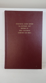
Book - Geographical Survey, Geographical Survey Report 31st Dec. 1977 prepared by Thos. Couchman Secretary for Mines
... Kiewa Valley Historical Society Mount Beauty Information Centre 31 Bogong High Plains Rd Mt Beauty high-country Office of Mines published progressive reports on the Geological Survey of parts of Victoria. This book includes a chapter on 'Dargo ...Office of Mines published progressive reports on the Geological Survey of parts of Victoria.This book includes a chapter on 'Dargo and Bogong' Pages 96 - 117 and includes a fold out map of this area. These pages show heavy use.Hard deep red cover with gold printed title located at the centre top. Bound with spine blank. 217 pages. Date 1878 First chapter and some pages have pencil marks including page 97.geological survey 1878, dargo, bogong -
 Wodonga & District Historical Society Inc
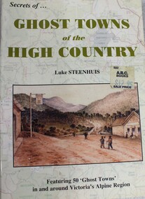
Book - Ghost Towns of the High Country, Luke Steenhuis, 1998
... Towns include Boggy Creek, Brandy Creek, Brocket, Brookville, Buckland, Buckland Upper, Bulgoback, Bulltown, Hogtown, Bullumwaal, Canvastown, Cassilis, Cobbannah, Copenhagen, Dargo High Plains, Dartmouth, Deptford, Gibbo River, Gladstone, Glen Dart, Glen Valley, Glen Wills, Good Luck Creek, Granite Flat, Grant, Hinnomunjie, Howittville, Jeff Davis, Lightning Creek, Louisville, Mayford, Merrijig Creek, Mitchelldale, Mount Elmo, Nugong, Sassafras, Saltpetre, Staleyville, Stirling, Store Creek, Summer Hill, Sunnyside, Tabberabbera, Talbotville, Thiel Town, Tongio West, Waterford, Wentworth River, Winchester, Wombat, Wongungarra, Zulu Creek. ...Stories and information about former towns in and around Victoria's Alpine Region. Towns include Boggy Creek, Brandy Creek, Brocket, Brookville, Buckland, Buckland Upper, Bulgoback, Bulltown, Hogtown, Bullumwaal, Canvastown, Cassilis, Cobbannah, Copenhagen, Dargo High Plains, Dartmouth, Deptford, Gibbo River, Gladstone, Glen Dart, Glen Valley, Glen Wills, Good Luck Creek, Granite Flat, Grant, Hinnomunjie, Howittville, Jeff Davis, Lightning Creek, Louisville, Mayford, Merrijig Creek, Mitchelldale, Mount Elmo, Nugong, Sassafras, Saltpetre, Staleyville, Stirling, Store Creek, Summer Hill, Sunnyside, Tabberabbera, Talbotville, Thiel Town, Tongio West, Waterford, Wentworth River, Winchester, Wombat, Wongungarra, Zulu Creek.non-fictionStories and information about former towns in and around Victoria's Alpine Region. Towns include Boggy Creek, Brandy Creek, Brocket, Brookville, Buckland, Buckland Upper, Bulgoback, Bulltown, Hogtown, Bullumwaal, Canvastown, Cassilis, Cobbannah, Copenhagen, Dargo High Plains, Dartmouth, Deptford, Gibbo River, Gladstone, Glen Dart, Glen Valley, Glen Wills, Good Luck Creek, Granite Flat, Grant, Hinnomunjie, Howittville, Jeff Davis, Lightning Creek, Louisville, Mayford, Merrijig Creek, Mitchelldale, Mount Elmo, Nugong, Sassafras, Saltpetre, Staleyville, Stirling, Store Creek, Summer Hill, Sunnyside, Tabberabbera, Talbotville, Thiel Town, Tongio West, Waterford, Wentworth River, Winchester, Wombat, Wongungarra, Zulu Creek.ghost towns, high country victoria, pioneers, history victoria