Showing 25 items matching "deep flow"
-
 Victorian Harness Racing Heritage Collection at Lord's Raceway Bendigo
Document - Record, Harness Horse, Deep Flow
... Deep Flow......deep flow...Deep Flow Document Record, Harness Horse ...Stephen Spark compiled horses performance records starting in 1983 on his typewriter. Deep Flow raced from 1971 (4yo) through to 1974 then raced in US from 1974 until 1980 (13yo). Career: 69 wins 35 seconds 28 thirds 227 starts.Typed document in black and red ink.harness racing, australasian harness racing, horse career, performance records, bendigo harness racing club, bhrc, deep flow, r adams, ross adams, r lemon, ron lemon -
 Sunbury Family History and Heritage Society Inc.
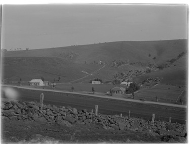
Photograph, Bulla township
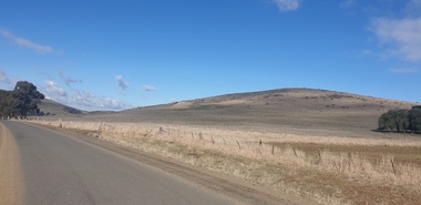
... The creek is the Deep Creek which flows into the Maribyrnong River further downstream. ...The creek is the Deep Creek which flows into the Maribyrnong River further downstream. ...The settlement is Bulla township, which attracted Europeans in the 1840s. The bluestone building on the RHS was one of the early hotels in the town but was the Post Office and store until it was destroyed by fire in the 1980s. The school is visible behind a clump of trees in the valley. The road in the foreground is the former Bulla Road, which in the 1850s carried traffic to the Bendigo goldfields. The creek is the Deep Creek which flows into the Maribyrnong River further downstream. In the early days of European settlement, minerals were obtained in the valley at Bulla. Today Felspar and Quartz Streets bear evidence of this early industry in the town. A non-digital old black and white scanned photograph of a small country settlement, with 6 buildings in a valley. The surrounding hills are bare with very little tree growth. A road way is in the foreground and a small creek is in the middle distance.bulla bulla, bulla township, deep creek, minerals -
 The Beechworth Burke Museum
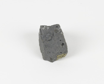
Geological specimen - Basalt (igneous-volcanic) containing Olivine, unknown
... flows. According to H. M. King (on geology.com) "Olivine is thought to be an important mineral in Earth's mantle. Its presence as a mantle mineral has been inferred by a change in the behaviour of seismic waves as they cross the boundary between Earth's crust and mantle". Lava from Mount Franklin and other volcanoes in the area filled valleys and buried the gold bearing streams that became the renowned ‘deep...flows. According to H. M. King (on geology.com) "Olivine is thought to be an important mineral in Earth's mantle. Its presence as a mantle mineral has been inferred by a change in the behaviour of seismic waves as they cross the boundary between Earth's crust and mantle". Lava from Mount Franklin and other volcanoes in the area filled valleys and buried the gold bearing streams that became the renowned ‘deep ...This particular geological specimen was found in Mount Franklin or Lalgambook in Djadjawurrung, located between Daylesford and Newstead, approximately ninety minutes drive from Melbourne. The mountain is an example of a breached scoria cone (a steep conical hill of loose pyroclastic fragments) which was created by a volcanic eruption about 470,000 years ago, a date which may indicate the age of this geological specimen. The volcanic eruptions of Mount Franklin were most likely witnessed by members of the Dja Dja Wurrung Aboriginal tribe, who referred to this country as the 'smoking grounds'. Mount Franklin and the surrounding area appears to have been a place of considerable religious significance to Aboriginal people, there is evidence which indicates that frequent large ceremonial gatherings took place in the area. Basalt is the most common rock on Earth’s surface, more than 90% of all volcanic rock on Earth is basalt. Basalt is an aphanitic extrusive igneous rock formed from the rapid cooling of low-viscosity lava exposed at or very near the surface of a rocky planet or moon. Specimens are black in colour and weather to dark green or brown. Basalt is rich in iron and magnesium and is mainly composed of olivine, pyroxene, and plagioclase. Olivine is the name of a group of rock-forming silicate minerals with compositions ranging between Mg2SiO4 and Fe2SiO4. Unlike other minerals, Olivine has a very high crystallisation temperature which makes it the first of the minerals to crystallise from magma. As magma cools, the crystals begin to form and settle on the bottom of the lava and form basalts that are abnormally enriched in olivine in the lower part of lava flows. According to H. M. King (on geology.com) "Olivine is thought to be an important mineral in Earth's mantle. Its presence as a mantle mineral has been inferred by a change in the behaviour of seismic waves as they cross the boundary between Earth's crust and mantle". Lava from Mount Franklin and other volcanoes in the area filled valleys and buried the gold bearing streams that became the renowned ‘deep leads’ of the gold mining era. In 1852, as part of the Victorian gold rush, gold was discovered in the immediate area, this gold was created by lava flows during the Newer Volcanic period, which were mined intensively during the nineteenth century. Around 1865 the presence of a deep lead in Mount Franklin was established. Deep lead mining was initially unsuccessful, and it was not until the late 1870s that the Franklinford Gold Mining Company mined at Mount Franklin on a significant scale. A few years later the Mount Franklin Estate Gold Mining Company also struck gold, followed by the Shakespeare and Great Western companies in the mid-1880s. By the late 1880s, however, deep lead mining had ceased in the area. Soon after gold was discovered in 1851, Victoria’s Governor La Trobe wrote to the Colonial Office in London, urging ‘the propriety of selecting and appointing as Mineral Surveyor for this Colony a gentleman possessed of the requisite qualifications and acquaintance with geological science and phenomena’. Alfred Selwyn was appointed geological surveyor in Australia in 1852 which began the Geological Survey of Victoria. In 1853-69 the Geological Survey issued under Selwyn's direction sixty-one geological maps and numerous reports; they were of such high standard that a writer in the Quarterly Journal of the Geological Society of London bracketed the survey with that of the United States of America as the best in the world. During his years spent in Australia, Selwyn collected numerous significant geological specimens, examples of which are held in collections such as the Burke Museum.This geological specimen is an example of basalt and olivine which shows the volcanic lava activity and geographical specific nature of Mt Franklin as a significant volcanic site. According to Agriculture Victoria 'The crater is one of the deepest in the Central Highlands area. It is a major megacryst site with some of the largest known Victorian examples of megacrysts of augite and an orthoclase. The small parasitic mound of Lady Franklin on the western flanks adds to the geological interest of the site'. This specimen also highlights the locality as a significant place for both indigenous activity and Victorian gold rush era mining practices. This specimen is part of a larger collection of geological and mineral specimens collected from around Australia (and some parts of the world) and donated to the Burke Museum between 1868-1880. A large percentage of these specimens were collected in Victoria as part of the Geological Survey of Victoria that begun in 1852 (in response to the Gold Rush) to study and map the geology of Victoria. Collecting geological specimens was an important part of mapping and understanding the scientific makeup of the earth. Many of these specimens were sent to research and collecting organisations across Australia, including the Burke Museum, to educate and encourage further study.An angular, solid hand-sized piece of grey volcanic Basalt with green/brown Olivine phenocrysts along one flat edge.Olivine in basalt / - label is probably / correct. / C. Willman / 15/4/21burke museum, beechworth, indigo shire, beechworth museum, geological, geological specimen, mineralogy, basalt, igneous rock, igneous-volcanic, volcanic geology, volcanic, olivine, olivine specimen, basaltoid -
 Bendigo Historical Society Inc.
Document - DRAINAGE PROBLEMS - INRUSH OF WATER AT THE VICTORIA QUARTZ
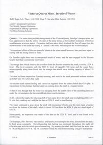
... The temperature of the incoming water was much higher than the Victoria Quartz was accustomed to bail, and this circumstance is significent in view of the increased temperature of the water at the deep levels in the New Chum Railway. Some months ago, the water commenced to flow from the New Chum Railway workings into the New Shenandoah, which is the next mine north. ...The temperature of the incoming water was much higher than the Victoria Quartz was accustomed to bail, and this circumstance is significent in view of the increased temperature of the water at the deep levels in the New Chum Railway. Some months ago, the water commenced to flow from the New Chum Railway workings into the New Shenandoah, which is the next mine north. ...Two handwritten copies of a Bendigo Advertiser report 16/6/1910 Page 7. This is a longer version of 3600.14. It was thought that the rush of water was from a dam bursting in one of the other mines, but as the water showed no signs of slowing that theory was discarded. The temperature of the incoming water was much higher than the Victoria Quartz was accustomed to bail, and this circumstance is significent in view of the increased temperature of the water at the deep levels in the New Chum Railway. Some months ago, the water commenced to flow from the New Chum Railway workings into the New Shenandoah, which is the next mine north. The water rose so rapidly that a disaster was narrowly averted. The mines along the line were connected at different levels and with the cessation of bailing at the deep levels in the southern mines, it was only to be expected that the water would find its way north to the Victoria Quartz. The water raised from the operating mines under the direction of the New Chum Drainage Association, a yeart or two ago used to exceed six million gallons per month. At that time there were eight companies bailing water, and even then some of the plants, especially those at the deep mines, were severely taxed in coping with the water, and performing ordinary work. Since some mines had discontinued bailing, the water has been filling up extensive workings, and as was predicted in the ''Advertiser'' some time ago, the Victoria Quartz Company could not expect to succeed with its deep sinking project without making some special provision for raising the water, which ultimately would become a source of trouble. The Victoria Quartz Company was allotted a special grant of 10,000 pound to assist in sinking the shaft 1000 ft from the 4254 ft level. Under the conditions of the grant, the Company had to contribute half the cost of the sinking, and the raising of the water has also been an exensive item. For the present, all attention will be concentrated in lowering the water, and should the appliances prove unequal to the task the deep sinking scheme can only be accomplished by resorting to some comprehensive system of combating the water'. Document from Albert Richardson Collection of mining history.document, gold, drainage problems, drainage problems, inrush of water at the victoria quartz, bendigo advertiser 16/6/1910 page 7, mine reports 13/6/1910, victoria quartz, lansell's 180, mr stevens, mr w abraham, new chum & victoria mine, new chum railway, new shenandoah, new chum drainage association -
 Bendigo Historical Society Inc.
Document - DRAINAGE PROBLEMS - MINERS SENSATIONAL EXPERIENCE AT THE VICTORIA QUARTZ
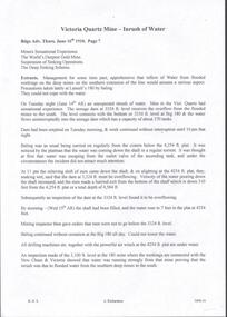
... deep mines to the south would affect them. Lansell's 180 took the precaution of baling. On the Tuesday night the men at the Victoria Quartz had a sensational experience. The storage dam at 3324 ft level receives the overflow from the flooded mines to the south. The level connects with the 3310 level at the Big 180. The water flows...deep mines to the south would affect them. Lansell's 180 took the precaution of baling. On the Tuesday night the men at the Victoria Quartz had a sensational experience. The storage dam at 3324 ft level receives the overflow from the flooded mines to the south. The level connects with the 3310 level at the Big 180. The water flows ...Handwritten notes from a Bendigo Advertiser report, Thursday June 16th 1910. Management had for some time been apprehensive that the flooding in the deep mines to the south would affect them. Lansell's 180 took the precaution of baling. On the Tuesday night the men at the Victoria Quartz had a sensational experience. The storage dam at 3324 ft level receives the overflow from the flooded mines to the south. The level connects with the 3310 level at the Big 180. The water flows uninterrupted into thestorage dam which has a capacity of about 270 tanks. The dam had been emptied on Tuesday morning and work continued until 10 pm that night. The platman noticed that the water was coming down the shaft in a regular torrent. They didn't take much notice as they thought it was a leakinig outlet valve on the ascending tank. At 11 pm the releiving shift came down the shaft and said that the dam at 3,324 ft must be overflowing. The velocity of the water pouring down the shaft increased and the men made a hurried exit from the bottom of the shaft which is down 310 ft from the 4.254 ft plat (a total depth of 4,564 ft). An inspection of the dam at the 3324 ft level found it to be overflowing. By morning (Wednesday) the shaft had filled, and the water rose to 7 ft in the plat at 4254 feet. Mining inspector hgave orders that men were not to go below the 3324 ft level. Baling continued without cessation at the Big 180 all day and could not lower the water. Drilling machines etc and a powerful air winch at the 4254 ft plat are under water. An inspection made of the 3100 ft level at the 180 mine where the workings are connected with the New Chum & Victoria showed that water was running strongly from that mine proving that the inrush was due to flooded water from the southern deep mines to the south. Document from Albert Richardson Collection of mining history. Document from Albert Richardson Collection of mining history.document, gold, drainage problems, new chum drainage scheme, miners sensational experience at the victoria quartz, bendigo advertiser 16/6/1910 page7, lansell's 180, big 180, new chum & victoria -
 Bendigo Historical Society Inc.
Document - DRAINAGE PROBLEMS - WATER PROBLEMS
... Notes mention making arrangements with other mines to resume bailing, Victoria Quartz still shaft sinking despite strong flow of water, Lansell's 180 preparing to bail water from the deep levels, so that the Victoria Quartz may continue shaft sinking and finishing cutting of plat at 4454 ft. ...Notes mention making arrangements with other mines to resume bailing, Victoria Quartz still shaft sinking despite strong flow of water, Lansell's 180 preparing to bail water from the deep levels, so that the Victoria Quartz may continue shaft sinking and finishing cutting of plat at 4454 ft. ...Two handwritten pages with extracts from the Bendigo Advertiser Mining Intelligence. Notes mention making arrangements with other mines to resume bailing, Victoria Quartz still shaft sinking despite strong flow of water, Lansell's 180 preparing to bail water from the deep levels, so that the Victoria Quartz may continue shaft sinking and finishing cutting of plat at 4454 ft. Also a weather report on the 14/6/1910. From the Albert Richardson Mining History Collection.gold, drainage problems, drainage problems, water problems, bendigo advertiser mining intelligence 18/4/1910, 9/5/1910, 23/5/1910, 30/5/1910, 6/6/1910, 13/6/1910, victoria quartz, lazarus coy, lansell's 180, albert richardson -
 Federation University Historical Collection
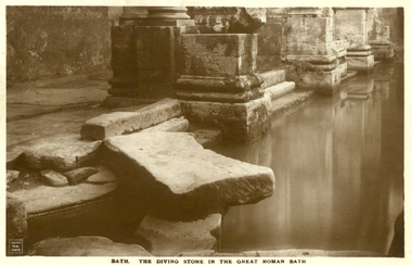
Postcard - Sepia, The Diving Stone in the Great Roman Bath, Bath, Somerset
... deep, which was ideal for bathing, and it has steps leading down on all sides. Niches around the baths would have held benches for bathers and possibly small tables for drinks or snacks. A large flat slab of stone is set across the point where hot water flows...deep, which was ideal for bathing, and it has steps leading down on all sides. Niches around the baths would have held benches for bathers and possibly small tables for drinks or snacks. A large flat slab of stone is set across the point where hot water flows ...The Great Bath is a massive pool, lined with 45 sheets of lead, and filled with hot spa water. It once stood in an enormous barrel-vaulted hall that rose to a height of 40 metres. For many Roman visitors this may have been the largest building they had ever entered in their life. The bath is 1.6 metres deep, which was ideal for bathing, and it has steps leading down on all sides. Niches around the baths would have held benches for bathers and possibly small tables for drinks or snacks. A large flat slab of stone is set across the point where hot water flows into the bath. It is known today as the diving stone. The Roman Baths complex is a site of historical interest in the English city of Bath. The house is a well-preserved Roman site for public bathing. The Roman Baths themselves are below the modern street level. There are four main features: the Sacred Spring, the Roman Temple, the Roman Bath House and the Museum, holding finds from Roman Bath. The buildings above street level date from the 19th century. Sepia postcard of a section of the Great Roman Bath at Bath, Somerset featuring the Diving Stone.printed verso: The Diving Stone in the great roman bath. The Diving stone, at the north-west corner of the great Roman Bath, still shows where the feet of bygone bathers wore away its surface. The hot mineral waters flowed into the bath through a channel under this stone. chatham-holmes family collection, bath, great roman bath, swimming pool -
 Federation University Historical Collection
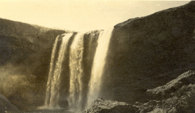
Photograph, Wannan Falls near Hamilton
... Wannon Falls were created by lava flows that surged upstream to the Wannon River. The cascade is a 30 metre vertical drop into a deep plunge pool. ...Barker Library (top floor) Mount Helen goldfields Wannon Falls were created by lava flows that surged upstream to the Wannon River. The cascade is a 30 metre vertical drop into a deep plunge pool. ...Wannon Falls were created by lava flows that surged upstream to the Wannon River. The cascade is a 30 metre vertical drop into a deep plunge pool. Downstream rapids wind their way around large blocks of basalt. The Wannon Falls have been painted by notable artists such as Nicholas Chevalier, Eugene von Guerard, Thomas Clark and Louis Buvelot.Black and white photograph of a waterfall cascade known as Wannon Falls.Verso in black ink handwriting 'Wannon Falls near Hamilton'chatham family archive, chatham, wannon falls, hamilton, waterfall -
 Coal Creek Community Park & Museum
Black ink
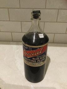
... AUSTRALIA - The Celebrated "Commercial" Blue Black Writing Fluid Writes a deep blue colour and soon changes to a very deep Black. It is non-corrosive and flows cleanly and freely from the pen, and will keep for years in any climate. - Contents 20 Fl. ...AUSTRALIA - The Celebrated "Commercial" Blue Black Writing Fluid Writes a deep blue colour and soon changes to a very deep Black. It is non-corrosive and flows cleanly and freely from the pen, and will keep for years in any climate. - Contents 20 Fl. ...8674.1 - Clear glass bottle with paper label and plastic cork style lid.- TRADE MARK - Commercial blue black writing ink. - Manufactured by Angus & Co. PTY. LTD. AUSTRALIA - The Celebrated "Commercial" Blue Black Writing Fluid Writes a deep blue colour and soon changes to a very deep Black. It is non-corrosive and flows cleanly and freely from the pen, and will keep for years in any climate. - Contents 20 Fl. Oz. -
 Sunshine and District Historical Society Incorporated
Photograph - Kororoit Creek Photograph Compilation
... flows through Albion, Deer Park & Sunshine. It is a vital ecological corridor and recreational trail, known for its basalt cliffs, revegetation efforts, and community significance. Kororoit Creek has deep...flows through Albion, Deer Park & Sunshine. It is a vital ecological corridor and recreational trail, known for its basalt cliffs, revegetation efforts, and community significance. Kororoit Creek has deep ...Kororoit Creek flows through Albion, Deer Park & Sunshine. It is a vital ecological corridor and recreational trail, known for its basalt cliffs, revegetation efforts, and community significance. Kororoit Creek has deep Aboriginal significance, with evidence of long-standing occupation and cultural practices along its banks. The area surrounding Kororoit Creek is part of the traditional lands of the Wurundjeri Woi-wurrung people, who belong to the Kulin Nation. The name Kororoit is thought to have been derived from an Aboriginal word meaning male kangaroo, but the meaning is in dispute, the name may be also derived from the Woiwurrung language, meaning “Creek on the western plain".Korotoit Creek 8/6/2010kororoit creek -
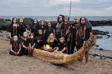 Merri-bek City Council
Photograph - Digital print on photographic paper, Maree Clarke, The Long Journey Home 4, 2024
... deep connection of First Nations culture to Country, the two works serve as a poignant reminder that these communities have always cared for the land and waterways we inhabit. Their inclusion in the Art Collection exemplifies Council’s commitment to strengthening the diversity of the Merri-bek Art Collection and its First Nations art component and demonstrates the Council’s respect for the natural landscapes and traditional First Nations practices. Both works were commissioned for and exhibited in Future River: When the Past Flows ... -
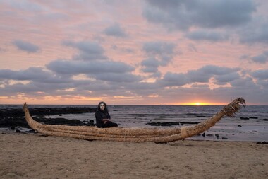 Merri-bek City Council
Photograph - Digital print on photographic paper, Maree Clarke, The Long Journey Home 9, 2024
... deep connection of First Nations culture to Country, the two works serve as a poignant reminder that these communities have always cared for the land and waterways we inhabit. Their inclusion in the Art Collection exemplifies Council’s commitment to strengthening the diversity of the Merri-bek Art Collection and its First Nations art component and demonstrates the Council’s respect for the natural landscapes and traditional First Nations practices. Both works were commissioned for and exhibited in Future River: When the Past Flows ... -
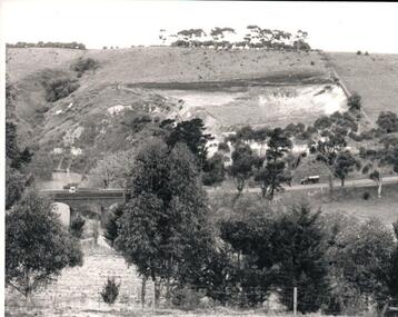 Hume City Civic Collection
Photograph, Early 1970s
... The three arched bluestone bridge r3placed a ford crossing across Deep Creek, which along with Jacksons Creek flows into the Maribyrnong River....The three arched bluestone bridge r3placed a ford crossing across Deep Creek, which along with Jacksons Creek flows into the Maribyrnong River. deep creek bridges kaolin quarries quarries george evans collection A black and white photograph of the Deep Creek and three arched bluestone bridge in the Bulla Township with the Kaolin Quarry in the background. ...The Kaolin Quarry at Bulla supplied Kaolin to the Northcote and Brunswick Pottery Works until it ceased operation at that site in the 1950s. The three arched bluestone bridge r3placed a ford crossing across Deep Creek, which along with Jacksons Creek flows into the Maribyrnong River.A black and white photograph of the Deep Creek and three arched bluestone bridge in the Bulla Township with the Kaolin Quarry in the background. One truck is crossing the bridge with a tanker approaching the bridge at the bottom of the Bulla Hill.deep creek, bridges, kaolin quarries, quarries, george evans collection -
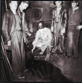 Lakes Entrance Historical Society
Photograph - Oil Industry, H D Bulmer, 1945
... Lakes Entrance Historical Society 4 Marine Parade Lakes Entrance gippsland Also six black and white photographs showing activities and machinery in workroom of Lakes Oil Limited deep shaft Lakes Entrance 05322.1, .2, .3, .4, .5, .6 All 17 x 17 cm Oil and Gas Industry Black and white photograph showing Mr Demaine Manager Director of Lakes Oil Limited with his hand in the oil flow with four workmen in the workrooms of the oil shaft. ...Also six black and white photographs showing activities and machinery in workroom of Lakes Oil Limited deep shaft Lakes Entrance 05322.1, .2, .3, .4, .5, .6 All 17 x 17 cmBlack and white photograph showing Mr Demaine Manager Director of Lakes Oil Limited with his hand in the oil flow with four workmen in the workrooms of the oil shaft. Plus six black and white photographs of operations at same oil well site Lakes Entrance Victoriaoil and gas industry -
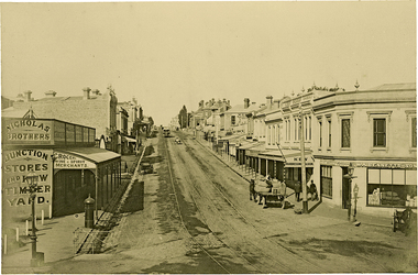 Kew Historical Society Inc
Photograph, J F C Farquhar, High Street, Kew, 1891
... It was unpaved and edged with deep bluestone gutters, which were designed to channel the significant flow of storm water down the hill to and beyond the Junction. ...It was unpaved and edged with deep bluestone gutters, which were designed to channel the significant flow of storm water down the hill to and beyond the Junction. ...At the beginning of the 1890s, the Kew businessman and Town Councillor, Henry Kellett, commissioned J.F.C. Farquhar to photograph scenes of Kew. These scenes included panoramas as well as pastoral scenes. The resulting set of twelve photographs was assembled in an album, Kew Where We Live, from which customers could select images for purchase.The preamble to the album describes that the photographs used the ‘argentic bromide’ process, now more commonly known as the gelatine silver process. This form of dry plate photography allowed for the negatives to be kept for weeks before processing, hence its value in landscape photography. The resulting images were considered to be finely grained and everlasting. Evidence of the success of Henry Kellett’s venture can be seen today, in that some of the photographs are held in national collections.It is believed that the Kew Historical Society’s copy of the Kellett album is unique and that the photographs in the book were the first copies taken from the original plates. It is the first and most important series of images produced about Kew. The individual images have proved essential in identifying buildings and places of heritage value in the district.In 1891, High Street was the centre of commercial activity in the Borough of Kew. It was unpaved and edged with deep bluestone gutters, which were designed to channel the significant flow of storm water down the hill to and beyond the Junction. On either side of the entrance to the shopping strip are two cast iron gas lamps that provided the only public street lighting before the Post Office was reached. Most shops, including the Nicholas Brothers’ Junction Store featured cast iron verandas. Further up the hill, Dougherty’s Greyhound Hotel was by this stage a local institution. Apart from the horse-drawn tram, the main form of personal and commercial transport in this period remained the horse, horse and cart, or buggy.The panoramic view predates the widening of High Street in the 20th century, and thus includes the original alignment of buildings on the south side. These included Henry Kellett’s shop.High Street, Kewkew illustrated, kew where we live, photographic books, henry kellett, high street - kew (vic) -
 Whitehorse Historical Society Inc.
Functional object - Slide/Film Strip Projector, c1960
... Deep Creek Road Mitcham melbourne The donor received the projector from a relative. He used it in the City of Whitehorse and surrounding areas photography projectors Waterworth Hobart 5553A Waterworth Slide Film Strip Projector, Model A - 300 watt, without a fan but with ventilating slots on top and an open bottom for air to flow. ...The donor received the projector from a relative. He used it in the City of Whitehorse and surrounding areasWaterworth Slide Film Strip Projector, Model A - 300 watt, without a fan but with ventilating slots on top and an open bottom for air to flow. It has a carrying handle and a power lead with 3 pin plug which is wired in permanently. The projector lamp is at rear under the carrying handle. Image is projected through three stage lens via via the image on the 35mm strip or slide. The front lens is adjustable for focus. A knurled nut enables a height adjustment at front. Slides are inserted through the holder - whilst one slide is shown the other can be loaded ready to be slid in front of the light. The film strip holder is missing. The unit is finished in a grey hammer finish paint used in 1960 t0 1980s. The operating instructions are filed in the supplementary envelope. The projector is stored in a hand made three ply hinged box.Waterworth Hobart 5553Aphotography, projectors -
 Whitehorse Historical Society Inc.
Article, Lake Rd Site for Housing, 8/04/1992 12:00:00 AM
... Whitehorse Historical Society Inc. 2-10 Deep Creek Road Mitcham melbourne land subdivision forest hill residential kindergarten lake road forest hill jean street phillips bruce delaney mark glen valley road Lake Rd Site for Housing. An article in the Nunawading Gazette on an objection by Mark Delaney on the traffic flow ...Lake Rd Site for Housing.An article in the Nunawading Gazette on an objection by Mark Delaney on the traffic flow and hazards associated with the proposed development of land on the former Forest Hill Residential Kindergarten land.Lake Rd Site for Housing.land subdivision, forest hill residential kindergarten, lake road, forest hill, jean street, phillips, bruce, delaney, mark, glen valley road -
Whitehorse Historical Society Inc.
Pamphlet, Wunderlich Terra Cotta Roofing Tiles
... Whitehorse Historical Society Inc. 2-10 Deep Creek Road Mitcham melbourne wunderlich limited tile factories Manufacturing flow chart of Wunderlich Terra Cotta Roofing Tiles and Commentary on factory tour of Wunderlich Ltd giving detailed description of process. ...Manufacturing flow chart of Wunderlich Terra Cotta Roofing Tiles and Commentary on factory tour of Wunderlich Ltd giving detailed description of process.Manufacturing flow chart of Wunderlich Terra Cotta Roofing Tiles and Commentary on factory tour of Wunderlich Ltd giving detailed description of process.Manufacturing flow chart of Wunderlich Terra Cotta Roofing Tiles and Commentary on factory tour of Wunderlich Ltd giving detailed description of process.wunderlich limited, tile factories -
 Whitehorse Historical Society Inc.
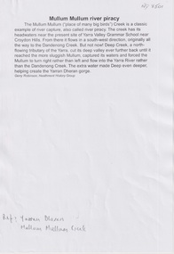
Document, Mullum Mullum River Piracy, 2025
... Mullum Mullum Creek originally flowed into Dandenong Creek until Deep Creek cut a deep valley to capture its waters to flow into the Yarra River....Whitehorse Historical Society Inc. 2-10 Deep Creek Road Mitcham melbourne Mullum Mullum Creek originally flowed into Dandenong Creek until Deep Creek cut a deep valley to capture its waters to flow into the Yarra River. ...The history of Mullum Mullum CreekA4 8pnon-fictionThe history of Mullum Mullum Creekyarran dheran, mullum mullum creek -
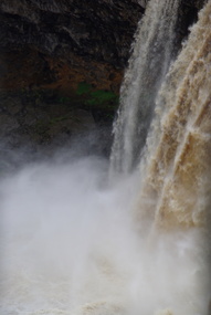 Ballarat Heritage Services
Photograph - Photograph - Colour, Wannon Falls, 2012, 18/08/2012
... Located 20km from Hamilton and around 15 km from Coleraine, the Wannon Falls present a spectacular display of water flowing down the falls into a deep plunge pool below. The falls were created by basalt lava flow that surged up stream to the Wannon River....Ballarat Heritage Services PO Box 2209 Bakery Hill Post Office goldfields Located 20km from Hamilton and around 15 km from Coleraine, the Wannon Falls present a spectacular display of water flowing down the falls into a deep plunge pool below. The falls were created by basalt lava flow that surged up stream to the Wannon River. warrnambool hopkins river mouth sea wannon falls Colour photographs of Wannon Falls, Victoria. ...Located 20km from Hamilton and around 15 km from Coleraine, the Wannon Falls present a spectacular display of water flowing down the falls into a deep plunge pool below. The falls were created by basalt lava flow that surged up stream to the Wannon River.Colour photographs of Wannon Falls, Victoria.warrnambool, hopkins river, mouth, sea, wannon falls -
 Ballarat Heritage Services
Photograph - Colour Photograph, Clare Gervasoni, Mount Greenock, 2025, 28/06/2025
... Mt Greenock is an extinct volcano with lava flows associated with a deep lead. It is a tall scoria cone with a broad shallow crater open to the northwest. ...Ballarat Heritage Services PO Box 2209 Bakery Hill Post Office goldfields Mt Greenock is an extinct volcano with lava flows associated with a deep lead. It is a tall scoria cone with a broad shallow crater open to the northwest. ...Mt Greenock is an extinct volcano with lava flows associated with a deep lead. It is a tall scoria cone with a broad shallow crater open to the northwest. In the crater are blocks and bombs of scoriaceous basalt. Long lava flows extend both north and south from the cone. It is considered a significant geological site, and part of the Major Mitchell Trail, with a 1936 ‘Centenary of Major Mitchell ‘monument on the summit. The flow to the north has been eroded by McCallum Creek which is a lateral stream. On the eastern base of the cone, the stream valley exposes a lava flow and underlying sedimentary rocks. The lava flow and the scoria cone overlie the Greenock lead (a buried valley with auriferous gravels). A line of mine tailing and abandoned mining relics associated with the former Union Mine occur on the margins of the lava flow. Mount Greenock is a 120 hectare ‘Geological Reserve’, is one of the few large scoria cones on public land and contains abundant outcrop and morphological evidence of its volcanic origin. Colour Photographs of Mt Greenock, near Talbot, Victoria. The photographs were taken in winter not long after the first post drought rains. Mt Greenock was climbed by Major Thomas Mitchell on 26 September 1936, and he gave it the current name. At that time the mount was part of Alexander McCallum's Dunach Forest Pastoral Run.mt greenock, mount greenock, mining, mullock heap, mt greenock geological reserve, union mine, volcanic grasslands, dunach -
 Ballarat Heritage Services
Photograph - Colour Photograph, Clare Gervasoni, Built Remains near Mount Greenock, 2025, 28/06/2025
... Mt Greenock is an extinct volcano with lava flows associated with a deep lead. It is a tall scoria cone with a broad shallow crater open to the northwest. ...Ballarat Heritage Services PO Box 2209 Bakery Hill Post Office goldfields Mt Greenock is an extinct volcano with lava flows associated with a deep lead. It is a tall scoria cone with a broad shallow crater open to the northwest. ...Mt Greenock is an extinct volcano with lava flows associated with a deep lead. It is a tall scoria cone with a broad shallow crater open to the northwest. In the crater are blocks and bombs of scoriaceous basalt. Long lava flows extend both north and south from the cone. It is considered a significant geological site, and part of the Major Mitchell Trail, with a 1936 ‘Centenary of Major Mitchell ‘monument on the summit. The flow to the north has been eroded by McCallum Creek which is a lateral stream. On the eastern base of the cone, the stream valley exposes a lava flow and underlying sedimentary rocks. The lava flow and the scoria cone overlie the Greenock lead (a buried valley with auriferous gravels). A line of mine tailing and abandoned mining relics associated with the former Union Mine occur on the margins of the lava flow. Mount Greenock is a 120 hectare ‘Geological Reserve’, is one of the few large scoria cones on public land and contains abundant outcrop and morphological evidence of its volcanic origin. Colour Photographs of bluestone and brick buildings at Mt Greenock, near Talbot, Victoria. The photographs were taken in winter not long after the first post drought rains. mt greenock, mount greenock, mining, mullock heap, mt greenock geological reserve, union mine, volcanic grasslands, dunach -
 Mont De Lancey
Container - Glass bottle
... This ink writes a beautiful blue color & changes to a deep and permanent black. It is non-corrosive & flows freely from the pen. ...This ink writes a beautiful blue color & changes to a deep and permanent black. It is non-corrosive & flows freely from the pen. ...Glass bottle full of ink with a cork stopper. It has a beige label with a blue rectangle, a red diagonal stripe and blue and white lettering.On the blue rectangle: "ANGUS & Co PTY LTD OFFICE BLUE BLACK WRITING FLUID". On the red diagonal stripe: "Special". Across the bottom of the label: "CONTENTS 32 Ozs. This ink writes a beautiful blue color & changes to a deep and permanent black. It is non-corrosive & flows freely from the pen. A perfect ink for office use. MANUFACTURED BY ANGUS & CO. PTY. LTD. AUST. CONTENTS 32 Ozsbottles, glassware -
Moorabbin Air Museum
Book - Fundamentals of Fighter Design, Ray Whitford
... The front is a deep blue with a stylization of air flow over a fighter concept. ...The front is a deep blue with a stylization of air flow over a fighter concept. ...This book covers the conceptual fundamentals of fighter design and operation. Covering multiple fighter designs and time periods, it covers the concepts that define the role and operation of fighter aircraft.The front is a deep blue with a stylization of air flow over a fighter concept. The back is a lighter blue with a photo of a jet fighter.non-fictionThis book covers the conceptual fundamentals of fighter design and operation. Covering multiple fighter designs and time periods, it covers the concepts that define the role and operation of fighter aircraft.fighters, aircraft -
 Bendigo Historical Society Inc.
Slide - Dunn's Rock Eppalock, 2012
... deep under the sea. Rocks mainly are sandstone, mudstone, black shale and quartz conglomerates. Marine fossils can be found in the area. Around seven million years ago a basalt flow...deep under the sea. Rocks mainly are sandstone, mudstone, black shale and quartz conglomerates. Marine fossils can be found in the area. Around seven million years ago a basalt flow ...The low rolling hills of the Kimbolton countryside consist of ancient, hard and fractured Ordovician rock up to 65 million years old, which was originally deposited deep under the sea. Rocks mainly are sandstone, mudstone, black shale and quartz conglomerates. Marine fossils can be found in the area. Around seven million years ago a basalt flow buried the original bedrock along the along the Campaspe River. Ongoing weathering, wind and water movement over the following years has produced younger clay, sand, silt and gravel deposits throughout the area. Patches of White Hills Gravel are also found in the area. Another unique geological feature of this area is the Permian Glacial Pavement rocks north and south of Eppalock and glacial sediments (such as “Dunn’s Rock” and “Kellams Rock”). During the ice age (up to 280 million years ago) large glaciers moving over the countryside, scoured out sediments, pulverized bedrock, polished and cut grooves into bedrock in the direction of ice movement. When the ice melted boulders etc where left behind in areas of entirely different rock types, such as a 100 Tonne granite block known as ‘The Stranger’ near Derrinal. Dunn's Rock (Glaciated Pavement) Eppalock - Photos of the rock and a field group collecting data with Lake Eppalock (Knowsley) in the backgroundhistory, bendigo, dunn's rock eppalock, kimbolton forest, lake eppalock, gately collection