Showing 292 items matching "demolished shops"
-
 Ringwood and District Historical Society
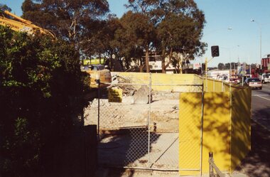
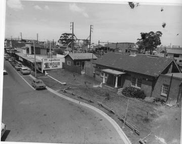
Photograph, Ringwood Railway Precinct circa 2009, Maroondah Highway looking west over demolished shops
... Ringwood Railway Precinct circa 2009, Maroondah Highway looking west over demolished shops...Ringwood and District Historical Society 125A Warrandyte Road Ringwood North melbourne Ringwood Railway Precinct circa 2009, Maroondah Highway looking west over demolished shops Photograph ... -
 Ringwood and District Historical Society
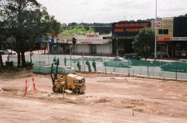
Photograph, Ringwood Railway Precinct with southside shops demolished and northside shops intact in 2009
... Ringwood Railway Precinct with southside shops demolished and northside shops intact in 2009...Ringwood and District Historical Society 125A Warrandyte Road Ringwood North melbourne Ringwood Railway Precinct with southside shops demolished and northside shops intact in 2009 Photograph ... -
 Ringwood and District Historical Society
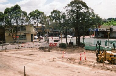
Photograph, Ringwood Railway Precinct in 2009, facing west towards former CE Carter premises and Melbourne Street, showing demolished corner shops
... Ringwood Railway Precinct in 2009, facing west towards former CE Carter premises and Melbourne Street, showing demolished corner shops...Ringwood and District Historical Society 125A Warrandyte Road Ringwood North melbourne Ringwood Railway Precinct in 2009, facing west towards former CE Carter premises and Melbourne Street, showing demolished corner shops Photograph ... -
 Williamstown Historical Society Inc
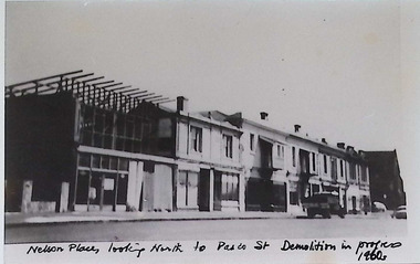
Photograph - Nelson Place, shops, 1965
... ...demolished shops...These old shops located near the corner of Nelson Place and Pascoe Street were demolished in 1965, to allow for the construction of the Nelson Heights Commission Flats. ...Nelson Place Nelson Heights demolished shops 1965 These old shops located near the corner of Nelson Place and Pascoe Street were demolished in 1965, to allow for the construction of the Nelson Heights Commission Flats. ...These old shops located near the corner of Nelson Place and Pascoe Street were demolished in 1965, to allow for the construction of the Nelson Heights Commission Flats. nelson place, nelson heights, demolished shops, 1965 -
 Williamstown Historical Society Inc
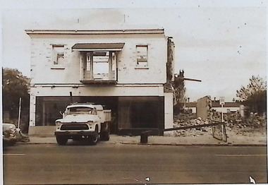
Photograph - Nelson Place, shops, 1960's
... ...demolished shops...Streetscape view of old shops which were demolished in 1965, to allow for the construction of the Nelson Heights Commission Flats. ...Nelson Place Nelson Heights demolished shops 1960's Streetscape view of old shops which were demolished in 1965, to allow for the construction of the Nelson Heights Commission Flats. ...Streetscape view of old shops which were demolished in 1965, to allow for the construction of the Nelson Heights Commission Flats. nelson place, nelson heights, demolished shops, 1960's -
 Williamstown Historical Society Inc
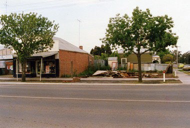
Photograph - Nelson Place, shops, 1965
... ...demolished shops...Streetscape view of old shops which were demolished in 1965, to allow for the construction of the Nelson Heights Commission Flats. ...Nelson Place Nelson Heights demolished shops 1965 Streetscape view of old shops which were demolished in 1965, to allow for the construction of the Nelson Heights Commission Flats. ...Streetscape view of old shops which were demolished in 1965, to allow for the construction of the Nelson Heights Commission Flats. nelson place, nelson heights, demolished shops, 1965 -
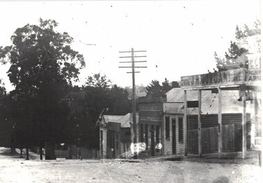
 Charlton Golden Grains Museum Inc
Photograph, Charlton Shire, c.1987
... Corner High Street and Learmonth Street. 2 shops demolished by Greg Fatheres. Shop on left Paterson's fruit and veg c.1935. ...Corner High Street and Learmonth Street, 2 Shops demolished by Greg Fathers...Charlton Golden Grains Museum Inc 1 High Street Charlton goldfields Corner High Street and Learmonth Street. 2 shops demolished by Greg Fatheres. Shop on left Paterson's fruit and veg c.1935. ...Corner High Street and Learmonth Street. 2 shops demolished by Greg Fatheres. Shop on left Paterson's fruit and veg c.1935. Butchers shop. rebuilt by Graeme Turner, Marini's take away cafe. Dalgety's, Building at back home of Sheisa Volch facing Learnmouth Street.Corner High Street and Learmonth Street, 2 Shops demolished by Greg Fathersdemolition, charlton, high street, shops, butcher, business, dalgety's, paterson -
 Kew Historical Society Inc
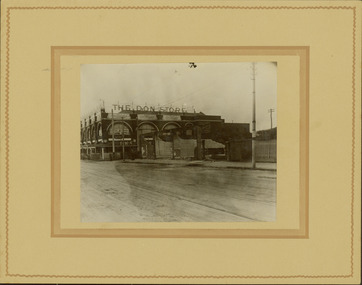
Photograph - Railway level crossing in Glenferrie Road, Glenferrie, E.J. Dower, 1912-13
... Annotated verso: "1912 / Demolishing shops near Glenferrie Railway Station, just prior to the regrading of line to camberwell / Taken by E.J. ...Railways -- Hawthorn Annotated verso: "1912 / Demolishing shops near Glenferrie Railway Station, just prior to the regrading of line to camberwell / Taken by E.J. ...One of a series of photographs, taken by Edgar James Dower in the second decade of the twentieth century. Born and raised in Olinda, his family later moved to Surrey Hills. He worked as an adult as a clerk in the city office of the Metropolitan Gas Company, and in his role as a 'collector', he was able to photograph scenes including the construction of tramlines and associated buildings in Kew, Hawthorn, Camberwell and Surrey Hills. Later he established a real estate agency with his brother - the E.J. Dower Real Estate Agency, Dandenong Office.The image is an historically significant record of the development of transport infrastructure which was used to connect Victorians in the first two decades of the twentieth century. This development resulted from increases in population and the consequent extension of Melbourne's suburbs. The photographs, both individually and collectively, richly detail the labour of workers and the tools and machinery used to create and extend Melbourne's public transport network in the years preceding and during World War 1.Digital copy of an original mounted photograph showing the old railway crossing in Glenferrie Road, Hawthorn. The removal of the train level crossing and the elevation of the rail line above the road was designed to enable the laying of tram tracks along Glenferrie Road. The buildings to the right of the photo were being demolished to allow for this. "The Don Store" is immediately behind the crossing.Annotated verso: "1912 / Demolishing shops near Glenferrie Railway Station, just prior to the regrading of line to camberwell / Taken by E.J. Dower 1912"theme --- travelling by tram, theme -- connecting victorians by transport and communications, glenferrie railway station, glenferrie road -- hawthorn (vic.), railways -- hawthorn -
 Ringwood and District Historical Society
Photograph, Maroondah Highway Central, Ringwood. Coffee Palace and shops towards Adelaide Street. c1966
... . & Adelaide St. c1966. Demolished 1966 for shopping centre"..... & Adelaide St. c1966. Demolished 1966 for shopping centre". Black and white photograph (2 copies). ...Black and white photograph (2 copies).Written on back of photograph: "Coffee Palace and Block Buildings Cr. Main St. & Adelaide St. c1966. Demolished 1966 for shopping centre". -
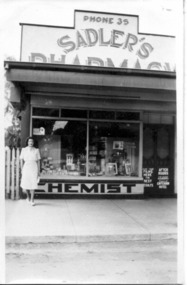 Tatura Irrigation & Wartime Camps Museum
Photograph, Sadler's Pharmacy 1940
... Later Colliver's Shop, demolished in 1989. Storefront with female standing in front. ...Later Colliver's Shop, demolished in 1989. Storefront with female standing in front. ...Black & white photograph of Dorothy Sadler's Pharmacy, opposite the post office 1940. Later Colliver's Shop, demolished in 1989. Storefront with female standing in front. tatura -
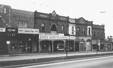
 Ringwood and District Historical Society
Photograph, Shops adjoining Bamfords. Ringwood. Probably 1958
... Shop of trio has a front that was taken from a shop demolished in Burke St. City. 1912. Boot shop run by Goodwin, formerly Clarke & Goodwin."...Shop of trio has a front that was taken from a shop demolished in Burke St. City. 1912. Boot shop run by Goodwin, formerly Clarke & Goodwin." ...Undated but probably 1958 as per #2373 (SS0187a)Written next to photograph, "Shops adjoining Bamfords. L.H. Shop of trio has a front that was taken from a shop demolished in Burke St. City. 1912. Boot shop run by Goodwin, formerly Clarke & Goodwin." -
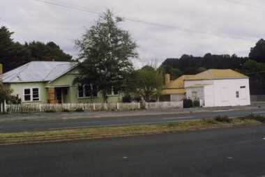 Linton and District Historical Society Inc
Photograph, Preston House and Shop, Sussex Street, Linton, 1988
... The shop closed in the 1970s and this photo taken in 1988 shows it without its original verandah. Dean Hart afterwards purchased the weatherboard house as a residence and demolished the shop building on the corner....The shop closed in the 1970s and this photo taken in 1988 shows it without its original verandah. Dean Hart afterwards purchased the weatherboard house as a residence and demolished the shop building on the corner. ...The white corner building was formerly a fruit and vegetable shop which was run by various generations of the Preston family, the last of whom was George Preston. The shop closed in the 1970s and this photo taken in 1988 shows it without its original verandah. Dean Hart afterwards purchased the weatherboard house as a residence and demolished the shop building on the corner.Colour photograph showing a green double-fronted weatherboard house in Sussex Street, Linton. The house has a chimney, pitched roof and a small porch, and a picket fence across the front. A smaller, white-painted building fronts the footpath on the corner of Sussex and Gillespie Streets.buildings, houses, shops, preston's shop, george preston, dean hart -
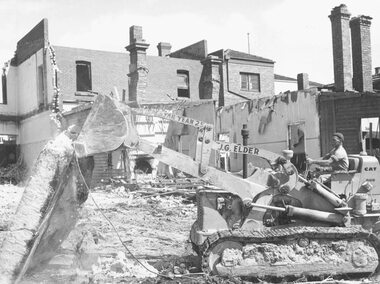 Ringwood and District Historical Society
Photograph, Maroondah Highway Central, Ringwood. Demolition of Coffee Palace, Main St. 1966
... Written on back of smaller duplicate photograph: "Demolishing Coffee Palace & shops cnr. Maroondah Hwy. & Adelaide St. ...Written on back of smaller duplicate photograph: "Demolishing Coffee Palace & shops cnr. Maroondah Hwy. & Adelaide St. ...Black and white photograph (2 copies- 1 large, 1 small)Typed below large photograph: "Demolition of Coffee Palace - Main St. 1966". Written on back of smaller duplicate photograph: "Demolishing Coffee Palace & shops cnr. Maroondah Hwy. & Adelaide St. (west cnr.) 1966. Portion of house on right - This was home of T. Grant, Blacksmith, 1883". -
 Box Hill Historical Society
Photograph - Scout Hall and shops in Main Street, 1/10/1975
... The Scout Hall and shops in Main Street in October, 1975.All the shops were demolished and the railway lowered when Box Hill Centro was built - now referred to as Centro South....The Scout Hall and shops in Main Street in October, 1975.All the shops were demolished and the railway lowered when Box Hill Centro was built - now referred to as Centro South. ...The Scout Hall and shops in Main Street in October, 1975.All the shops were demolished and the railway lowered when Box Hill Centro was built - now referred to as Centro South.Black and white photoscout halls, shops, main street -
 Melbourne Tram Museum
Postcard, Biscay Greetings, A class 243 (Route 48, North Balwyn) in Flinders St at Swanston St, mid 1980's
... In the background is the Port Phillip Arcade, ANZ bank and other shops demolished during 2018/9 for the Metro Tunnel works. ...In the background is the Port Phillip Arcade, ANZ bank and other shops demolished during 2018/9 for the Metro Tunnel works. ...Colour postcard divided back, four photo panels - Biscay Greetings, of A class 243 (Route 48, North Balwyn) in Flinders St at Swanston St. In the background is the Port Phillip Arcade, ANZ bank and other shops demolished during 2018/9 for the Metro Tunnel works. Back has space for name and address, stamp and a message and details of the postcard. Produced by Biscay Greetings, possibly mid 1980's. Card No. BG307trams, tramways, a class, flinders st, route 48, tram 243 -
 Kew Historical Society Inc
Archive (Sub-series) - Subject File, Copy Shop (Walpole Street, Kew), 1958-present
... Archive file containing information about The Copy Shop at 3 Walpole Street, Kew, which was located in the Council-owned Masonic Hall (demolished c.1983). ...Archive file containing information about The Copy Shop at 3 Walpole Street, Kew, which was located in the Council-owned Masonic Hall (demolished c.1983). ...Various partiesReference, Research, InformationSecondary Values (KHS Imposed Order)Subject file containing information about The Copy Shop at 3 Walpole Street, Kew, which was located in the Council-owned Masonic Hall (demolished c.1983). The Shop acted as a community Centre as well as being a self-help duplicating centre. At one stage, the Society had an Information Centre at the Shop. The file holds correspondence and printed materials. -
 Rutherglen Historical Society
Image, c April 1958
... Booklet - Rutherglen heritage walk : a self-guided tour of Rutherglen's Historic Streetscapes / by Rutherglen Wine Experience. 2009, p. 5 - states that the Red Boot Shop was "demolished sometime after WWII, and no trace remained until a wild storm uncovered the tiled entrance in the mid 2000's."...Rutherglen Historical Society Murray Street Rutherglen high-country Booklet - Rutherglen heritage walk : a self-guided tour of Rutherglen's Historic Streetscapes / by Rutherglen Wine Experience. 2009, p. 5 - states that the Red Boot Shop was "demolished sometime after WWII, and no trace remained until a wild storm uncovered the tiled entrance in the mid 2000's." main street rutherglen red boot shop ozone cafe harold hall alan zotti mccarthy On back of photo: "Ozone Café Main St Rutherglen | approx. ...Booklet - Rutherglen heritage walk : a self-guided tour of Rutherglen's Historic Streetscapes / by Rutherglen Wine Experience. 2009, p. 5 - states that the Red Boot Shop was "demolished sometime after WWII, and no trace remained until a wild storm uncovered the tiled entrance in the mid 2000's."Black and white photograph of the front of a café, with a central door flanked by two display windows. In tile, in front of the door, is the sign "The Red Boot Shop".On back of photo: "Ozone Café Main St Rutherglen | approx. April 1958 | purchased by Harold Hall March 1958 from McKinlays. | owners after H. Hall | McCarthy | Alan Zotti"main street rutherglen, red boot shop, ozone cafe, harold hall, alan zotti, mccarthy -
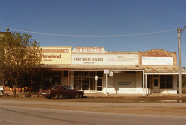 Charlton Golden Grains Museum Inc
Photograph, Charlton Shire, West end Charlton High St c. 1987, c.1987
... Built c. 1890s. The tree shops were demolished in early 1990s. The photo was taken by Shire Engineer c. 1987. ...Built c. 1890s. The tree shops were demolished in early 1990s. The photo was taken by Shire Engineer c. 1987. ...Shops at the western end, on the south side of High St Charlton showing Eddie Harris Mensland, McKinleys Land Sales Agency, Hillier's Dry Cleaners and Manchester Unity Agency. Built c. 1890s. The tree shops were demolished in early 1990s. The photo was taken by Shire Engineer c. 1987. Part of a series of photos taken by the Shire.Colour photograph of shops at the western end, on the south side of High St Charlton showing Eddie Harris Mensland, McKinleys Land Sales Agency, Hillier's Dry Cleaners and Manchester Unity Agency. Dark cloured car parked in front of McKinleys. Safety flags around tree to the left of the car. Signage in McKinley's window says 'Special Any Garments Only $'. Signage on Hillier's window says Nor-West Laundry & Dry Cleaners.business, industry, eddie harris mensland, charlton, high street -
 Linton and District Historical Society Inc
Photograph, Shops in Sussex Street, Linton, circa 1922
... What appears to be a laneway between the Morgan shop and the Ching dwelling was once occupied by the Surface Hill Hotel (demolished c.1911). ...What appears to be a laneway between the Morgan shop and the Ching dwelling was once occupied by the Surface Hill Hotel (demolished c.1911). ...Black and white copy of original photograph which shows the shop in Sussex Street owned by J. H. Morgan, the shop and dwelling owned by Richard Ching (telegraph pole in front), and the shop and dwelling owned by Annie Brown (née Nicholls). A small building between Ching's and Brown's shops may be the workshop of Dan McMillan, bootmaker. What appears to be a laneway between the Morgan shop and the Ching dwelling was once occupied by the Surface Hill Hotel (demolished c.1911). Shops in Sussex Street, Linton, c.1922: Morgan's, Ching's, Brown's. The original Bank of New South Wales building (by 1922 a private residence owned by the Lewers family) can just be seen further along the street, screened by a large tree.On reverse:"J. H. Morgans store Sussex St Linton c.1922".annie brown (née nicholls), j.h. morgan, richard ching, dan mcmillan -
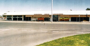 Wodonga & District Historical Society Inc
Photograph - Wodonga Business - Wodonga Home Furnishers
... demolished to make way for the Wodonga Home Furnishers. Mr Cheesley was a well-respected member of the community and served 13 years as a local councillor. He was often referred to as the council’s watchdog. His contribution is commemorated in the naming of the Les Cheesley Oval, Wodonga in his honour. Mr Cheesley died in Wodonga on 29th September 1994. The business continued to operate for a few more years but the shop...demolished to make way for the Wodonga Home Furnishers. Mr Cheesley was a well-respected member of the community and served 13 years as a local councillor. He was often referred to as the council’s watchdog. His contribution is commemorated in the naming of the Les Cheesley Oval, Wodonga in his honour. Mr Cheesley died in Wodonga on 29th September 1994. The business continued to operate for a few more years but the shop ...This popular furniture business was owned and operated by Mr Les Cheesley. In about 1963 the premises of Birrell's Bakery, Miss Hamilton's Corsetry, Gouge's Dry Cleaners, and the Dalgety NZ Loan Stock & Station Agents were demolished to make way for the Wodonga Home Furnishers. Mr Cheesley was a well-respected member of the community and served 13 years as a local councillor. He was often referred to as the council’s watchdog. His contribution is commemorated in the naming of the Les Cheesley Oval, Wodonga in his honour. Mr Cheesley died in Wodonga on 29th September 1994. The business continued to operate for a few more years but the shop was demolished in 1999 to make way for the realignment of Elgin Street in central Wodonga.A colour photo of the premises of Wodonga Home Furnishers in High Steet, Wodongawodonga businesses, high street wodonga, wodonga home furnishers, les cheesley -
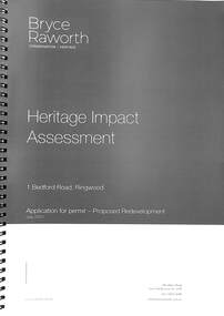 Ringwood and District Historical Society
Book, Bryce Raworth, Heritage Impact Assessment - 1 Bedford Road, Ringwood, Victoria. Application for permit - Proposed Redevelopment - July 2021, 2021
... It relates to a proposal to demolish the existing shop on the site and construct a multi-storey car park incorporating a commercial tenancy at the lower levels. ...It relates to a proposal to demolish the existing shop on the site and construct a multi-storey car park incorporating a commercial tenancy at the lower levels. ...A4 size wire-bound book compiled by Bryce RaworthINTRODUCTION: This heritage impact assessment (HIS) was prepared at the request of the City of Maroondah, the owner of the subject property at 1 Bedford Street (sic), Ringwood. It relates to a proposal to demolish the existing shop on the site and construct a multi-storey car park incorporating a commercial tenancy at the lower levels. It reviews the significance of the existing building on the site and the contribution it makes to the surrounding streetscapes, then comments on the heritage impacts of the proposed demolition in the context of the significance of the place and broader considerations. This office has previously provided an Historical Overview of the subject site (June 2020) and this assessment draws upon that previous research and analysis. The report has been prepared by Guy Murphy and Bryce Raworth. CONCLUSION: The proposed demolition of the former Blood Brothers Store at 1 Bedford Street (sic), Ringwood and the construction of a multi-storey car park on the enlarged site will result in the loss of some significance to the Heritage Overlay. The degree of loss is moderated by the partial intactness of the store, its modest character and the loss of its original setting, as well the proposal to implement a heritage interpretation strategy for the site. When considered in the context of the broader range of urban planning considerations and broader net community benefit, the proposed development is supported with respect to heritage impacts. -
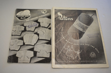 Warrnambool and District Historical Society Inc.
Knitting Pattern Book, Patons, 1940s
... Miss McClure had a lingerie and babywear shop at 114 Liebig Street before the building was demolished in 1953. ...Miss McClure had a lingerie and babywear shop at 114 Liebig Street before the building was demolished in 1953. This book is of minor interest as an example of a 1940s knitting pattern book and as a memento of Miss McClure’s shop in Liebig Street at that time. miss mcclure liebig street history of warrnambool knitting pattern books Fair Isles For the Family Miss McClure Liebig Street This is a booklet of 16 pages. ...This knitting pattern book dates from about the 1940s. Garments made with a Fair Isle pattern, especially sleeveless vests for men, were popular at that time. In the early to mid 20th century in Australia many of the woollen garments worn were handmade. Today this is not the case and hand-knitted garments are rare. Miss McClure had a lingerie and babywear shop at 114 Liebig Street before the building was demolished in 1953. This book is of minor interest as an example of a 1940s knitting pattern book and as a memento of Miss McClure’s shop in Liebig Street at that time. This is a booklet of 16 pages. It has a white cover with a red edging and black and white photographs and black printing on the front and back cover. The pages contain instructions for knitting six garments.Fair Isles For the Family Miss McClure Liebig Streetmiss mcclure, liebig street, history of warrnambool, knitting pattern books -
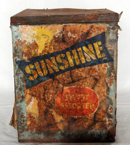 Orbost & District Historical Society
biscuit tin, after 1947
... demolished the workshop. Sunshine biscuits continued to be sold until 1991. Biscuits were sold by weight from a large tin in the grocer's shop.This tin seems to be a commercial tin used in a grocery shop. ...demolished the workshop. Sunshine biscuits continued to be sold until 1991. Biscuits were sold by weight from a large tin in the grocer's shop.This tin seems to be a commercial tin used in a grocery shop. ...Sunshine biscuits were made in Ballarat from 1921. During WW11 Sunshine biscuits devoted 80 percent of its output to army services. The company was twice devastated by fire. In 1923 the factory was completely destroyed and was rebuilt as a more modern factory on the same site. In 1939, a deliberately lit fire demolished the workshop. Sunshine biscuits continued to be sold until 1991. Biscuits were sold by weight from a large tin in the grocer's shop.This tin seems to be a commercial tin used in a grocery shop. It would have been used in an Orbost grocery store e.g. Dicken's, Baughhaust's or Herbert's.Biscuits were once sold by weight from a large tin in the grocer's shop.This tin seems to be a commercial tin used in a grocery shop. It would have been used in an Orbost grocery store e.g. Dicken's, Baughhaust's or Herbert's.Large rectangular commercial biscuit tin, made from pressed metal, with a lid. There is a paper label on the front which details the contents, and manufacturer details. It has a colourful label which is in poor condition. On label - in a dark blue banner SUNSHINE. Left hand side vertically BALLARAT PRODUCTS LIMITED. Below the SUNSHINE banner - Sweet Assorted, Superior biscuitssunshine-biscuits food biscuits container tin -
 Eltham District Historical Society Inc
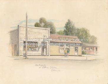
Artwork, other - Sketch, E. Foreman, Old property at Eltham Station, c.1980
... shop opposite Eltham Lower Park. That business run by Don Brown, then a local artist was taken over as River Clay run by Leo Haanappel and Coeny Dommers but ultimately sat in a flood plain and was demolished. ...shop opposite Eltham Lower Park. That business run by Don Brown, then a local artist was taken over as River Clay run by Leo Haanappel and Coeny Dommers but ultimately sat in a flood plain and was demolished. ...Situated at 965 Main Road adjacent to the Eltham Railway Station, the Country Art Store was originally a hairdresser and Tattersalls agency In 1968 Pam Robinson and Caroline Shenton opened a small shop on the corner of Main Road and Napoleon Street. Four months later a damaged fire hyrdant flooded the store and ruined all their stock. The pair moved to the former hardresser shop at 965 Main Road, adjacent to the Eltham Railway Station, opposite the Stationmaster's house and opened the Country Art Store and adjacent gallery. At the time the only other shop selling pottery was the Potters Cottage in Warrandyte. During the 1970s the gallery was the Wiregrass Gallery. In 1993, after 25 years operating the Country Art Store, the pair decided to sell up and move to warmer climates. During the course of their business a number of craft shops and galleries opened and closed in Eltham. One such shop was Bimbadeen, next to Ansell and Muir's chicken shop opposite Eltham Lower Park. That business run by Don Brown, then a local artist was taken over as River Clay run by Leo Haanappel and Coeny Dommers but ultimately sat in a flood plain and was demolished. When the Country Art Store became available in 1993, Leo Haanappel and Coeny Dommers took it over. The premises became Platform 3095 cafe around 2015.Old Property at Eltha Station E. Foremanart store, country art store, country art store (eltham), eltham railway station, platform 3095, restaurants, shops, wiregrass gallery -
 Eltham District Historical Society Inc
Photograph (Item) - Print, Elizabeth Simkin, Craft Galore, 1988
... Riverclay Craft Gallery, 573 Main Road, Eltham Riverclay was loacted along with Ansell and Muirs Chicken shop opposite El;tham Lower Park. The building has since been demolished as it lay within the 1934 flood plain limits. ...Eltham District Historical Society Inc 728 Main Rd Eltham melbourne Riverclay Craft Gallery, 573 Main Road, Eltham Riverclay was loacted along with Ansell and Muirs Chicken shop opposite El;tham Lower Park. The building has since been demolished as it lay within the 1934 flood plain limits. ...Riverclay Craft Gallery, 573 Main Road, Eltham Riverclay was loacted along with Ansell and Muirs Chicken shop opposite El;tham Lower Park. The building has since been demolished as it lay within the 1934 flood plain limits. Elizabeth Simkin 1988 Entrant No. 149 Ref: Series 34, Items 39, 111-113 SHIRE OF ELTHAM COMMUNITY PHOTOGRAPHIC SURVEY Photography is an artform which many of us practice, sometimes purely for artistic pursuit, sometimes to record the people and events in our lives. In 1988, as part of a local Bicentennial project, the Shire of Eltham conducted the Eltham Community Photographic Survey. Up to 100 entries were to be selected by a panel of photographers for entry into the Eltham Photographic Survey Exhibition. Entries had to be submitted by May 13, 1988. Entrants whose images were selected for the exhibition were contacted and requested to further submit an entry form providing entrant’s name, area of residence, age, and proposed captions. These details were then used to produce labels for the exhibition mounts. Where negatives had not been supplied, these were requested to support the display of printed enlargements mounted on 10” x 8” cardboard. The mounted prints were made available post exhibition for sale at $8.50 each for colour prints and $7.00 for B&W prints. Residents in the Shire were invited to collect a free roll of film and take a photograph of what they either liked or did not like about the area. A total of 160 entrants submitted multiple entries for the exhibition. Of those selected for exhibition, entrants ranged in age from 9 to 70 years. All custom colour and black and white printing for the exhibition was completed by Wattle Studios of Eltham. The Eltham Photographic Survey was jointly auspiced by the Shire of Eltham and Wattle Studios, of 953 Main Road, Eltham. The project was greatly assisted by: • David McRitchie, Media Studies Lecturer Victoria College, Rusden Campus. • Ian and Annette Toohill of Wattle Studios • Tracy Naughton, Eltham Community Arts Officer • Neville Emerson Pty. Ltd. • Superior Press, Eltham • Kodak Australasia Pty. Ltd. • Agfa Gevaert Ltd. • Townsend Colourtech Pty. Ltd. • The Australian Bicentennial Authority • Eleanor Bowers, Secretary, Eltham Arts Council The exhibition was placed on display in the Woolworths Arcade, Eltham between Monday June 6th and Saturday June 11, 1988. It was also intended to hold the exhibition at a venue in the Shire’s North Riding from Monday, June 20 to Friday June 24. It was then displayed at the Were Street Theatre, Montmorency from Friday, June 24 to Thursday, July 7. Series 34: Eltham Community Photographic Survey 1988 - Prints & Documentation Series consists of 117 photographs of Shire scenes taken by members of the community. Items I - 41 are larger photographs mounted on card, which were exhibited. Items 42 - 117 are unmounted copies, alternative takes and other entries. Corresponding negatives contained in Series 35: Eltham Community Photographic Survey 1988 – Negatives which consists of 267 colour and B&W negatives and one colour slide of Shire scenes taken by members of the community. The negatives are arranged by the entrant number of the photographer. The Eltham Community Photographic Survey collection is significant to the local community as it was curated by the local community - ordinary people of all ages - representing what they liked and did not like in the area where they lived. It represents an unfiltered representation of the Shire of Eltham as it was in 1988. It also represents one of many projects as part of the national programme of events and celebrations to commemorate the bicentenary. It is a time capsule of life in the 1980s of this urban and rural municipality in Melbourne's north. Front: Entrant No. and name on printed label Rear: Entrant No., name and address on printed label; also 'Series 34' and the 'Item No.' in pencilshire of eltham archives, bicentennial project, eltham, eltham community photographic survey, eltham photographic survey exhibition, series 34, series 35, elizabeth simkin, film - kodak ga 100 5095, riverclay craft gallery, scan - 35mm negative -
 Eltham District Historical Society Inc
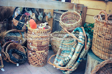
Photograph (Item) - Print, Elizabeth Simkin, Untitled (Cane baskets), 1988
... Riverclay Craft Gallery, 573 Main Road, Eltham Riverclay was located along with Ansell and Muir's Chicken shop opposite Eltham Lower Park. The building has since been demolished as it lay within the 1934 flood plain limits Elizabeth Simkin 1988 Entrant No. 149 Ref: Series 34, Items 39, 111-113 The photographer noted that in a sad indictment of the local community, this German Shepherd dog and another had been abandoned by their owners to scavenge through the bins and chase the drunks around the lake at dawn. ...Eltham District Historical Society Inc 728 Main Rd Eltham melbourne Riverclay Craft Gallery, 573 Main Road, Eltham Riverclay was located along with Ansell and Muir's Chicken shop opposite Eltham Lower Park. The building has since been demolished as it lay within the 1934 flood plain limits Elizabeth Simkin 1988 Entrant No. 149 Ref: Series 34, Items 39, 111-113 The photographer noted that in a sad indictment of the local community, this German Shepherd dog and another had been abandoned by their owners to scavenge through the bins and chase the drunks around the lake at dawn. ...Riverclay Craft Gallery, 573 Main Road, Eltham Riverclay was located along with Ansell and Muir's Chicken shop opposite Eltham Lower Park. The building has since been demolished as it lay within the 1934 flood plain limits Elizabeth Simkin 1988 Entrant No. 149 Ref: Series 34, Items 39, 111-113 The photographer noted that in a sad indictment of the local community, this German Shepherd dog and another had been abandoned by their owners to scavenge through the bins and chase the drunks around the lake at dawn. Both dogs were impounded and the owners never claimed them. As a consequence they were eventually both put down. The photographer noted that in a sad indictment of the local community, this German Shepherd dog and another had been abandoned by their owners to scavenge through the bins and chase the drunks around the lake at dawn. Both dogs were impounded and the owners never claimed them. As a consequence they were eventually both put down. SHIRE OF ELTHAM COMMUNITY PHOTOGRAPHIC SURVEY Photography is an artform which many of us practice, sometimes purely for artistic pursuit, sometimes to record the people and events in our lives. In 1988, as part of a local Bicentennial project, the Shire of Eltham conducted the Eltham Community Photographic Survey. Up to 100 entries were to be selected by a panel of photographers for entry into the Eltham Photographic Survey Exhibition. Entries had to be submitted by May 13, 1988. Entrants whose images were selected for the exhibition were contacted and requested to further submit an entry form providing entrant’s name, area of residence, age, and proposed captions. These details were then used to produce labels for the exhibition mounts. Where negatives had not been supplied, these were requested to support the display of printed enlargements mounted on 10” x 8” cardboard. The mounted prints were made available post exhibition for sale at $8.50 each for colour prints and $7.00 for B&W prints. Residents in the Shire were invited to collect a free roll of film and take a photograph of what they either liked or did not like about the area. A total of 160 entrants submitted multiple entries for the exhibition. Of those selected for exhibition, entrants ranged in age from 9 to 70 years. All custom colour and black and white printing for the exhibition was completed by Wattle Studios of Eltham. The Eltham Photographic Survey was jointly auspiced by the Shire of Eltham and Wattle Studios, of 953 Main Road, Eltham. The project was greatly assisted by: • David McRitchie, Media Studies Lecturer Victoria College, Rusden Campus. • Ian and Annette Toohill of Wattle Studios • Tracy Naughton, Eltham Community Arts Officer • Neville Emerson Pty. Ltd. • Superior Press, Eltham • Kodak Australasia Pty. Ltd. • Agfa Gevaert Ltd. • Townsend Colourtech Pty. Ltd. • The Australian Bicentennial Authority • Eleanor Bowers, Secretary, Eltham Arts Council The exhibition was placed on display in the Woolworths Arcade, Eltham between Monday June 6th and Saturday June 11, 1988. It was also intended to hold the exhibition at a venue in the Shire’s North Riding from Monday, June 20 to Friday June 24. It was then displayed at the Were Street Theatre, Montmorency from Friday, June 24 to Thursday, July 7. Series 34: Eltham Community Photographic Survey 1988 - Prints & Documentation Series consists of 117 photographs of Shire scenes taken by members of the community. Items I - 41 are larger photographs mounted on card, which were exhibited. Items 42 - 117 are unmounted copies, alternative takes and other entries. Corresponding negatives contained in Series 35: Eltham Community Photographic Survey 1988 – Negatives which consists of 267 colour and B&W negatives and one colour slide of Shire scenes taken by members of the community. The negatives are arranged by the entrant number of the photographer. The Eltham Community Photographic Survey collection is significant to the local community as it was curated by the local community - ordinary people of all ages - representing what they liked and did not like in the area where they lived. It represents an unfiltered representation of the Shire of Eltham as it was in 1988. It also represents one of many projects as part of the national programme of events and celebrations to commemorate the bicentenary. It is a time capsule of life in the 1980s of this urban and rural municipality in Melbourne's north. Rear: Entrant No., name and address in blue ink; also 'Series 34' and the 'Item No.' in orange inkshire of eltham archives, bicentennial project, eltham, eltham community photographic survey, series 34, series 35, elizabeth simkin, film - kodak ga 100 5095, riverclay craft gallery, scan - 35mm negative -
 Eltham District Historical Society Inc
Photograph (Item) - Negative, Elizabeth Simkin, Riverclay Craft Gallery, 573 Main Road, Eltham, 1988
... Riverclay was located along with Ansell and Muirs Chicken shop opposite El;tham Lower Park. The building has since been demolished as it lay within the 1934 flood plain limits. ...Eltham District Historical Society Inc 728 Main Rd Eltham melbourne Riverclay was located along with Ansell and Muirs Chicken shop opposite El;tham Lower Park. The building has since been demolished as it lay within the 1934 flood plain limits. ...Riverclay was located along with Ansell and Muirs Chicken shop opposite El;tham Lower Park. The building has since been demolished as it lay within the 1934 flood plain limits. Elizabeth Simkin 1988 Entrant No. 149 Ref: Series 34, Items 39, 111-113 The images in this record were not selected for inclusion. SHIRE OF ELTHAM COMMUNITY PHOTOGRAPHIC SURVEY Photography is an artform which many of us practice, sometimes purely for artistic pursuit, sometimes to record the people and events in our lives. In 1988, as part of a local Bicentennial project, the Shire of Eltham conducted the Eltham Community Photographic Survey. Up to 100 entries were to be selected by a panel of photographers for entry into the Eltham Photographic Survey Exhibition. Entries had to be submitted by May 13, 1988. Entrants whose images were selected for the exhibition were contacted and requested to further submit an entry form providing entrant’s name, area of residence, age, and proposed captions. These details were then used to produce labels for the exhibition mounts. Where negatives had not been supplied, these were requested to support the display of printed enlargements mounted on 10” x 8” cardboard. The mounted prints were made available post exhibition for sale at $8.50 each for colour prints and $7.00 for B&W prints. Residents in the Shire were invited to collect a free roll of film and take a photograph of what they either liked or did not like about the area. A total of 160 entrants submitted multiple entries for the exhibition. Of those selected for exhibition, entrants ranged in age from 9 to 70 years. All custom colour and black and white printing for the exhibition was completed by Wattle Studios of Eltham. The Eltham Photographic Survey was jointly auspiced by the Shire of Eltham and Wattle Studios, of 953 Main Road, Eltham. The project was greatly assisted by: • David McRitchie, Media Studies Lecturer Victoria College, Rusden Campus. • Ian and Annette Toohill of Wattle Studios • Tracy Naughton, Eltham Community Arts Officer • Neville Emerson Pty. Ltd. • Superior Press, Eltham • Kodak Australasia Pty. Ltd. • Agfa Gevaert Ltd. • Townsend Colourtech Pty. Ltd. • The Australian Bicentennial Authority • Eleanor Bowers, Secretary, Eltham Arts Council The exhibition was placed on display in the Woolworths Arcade, Eltham between Monday June 6th and Saturday June 11, 1988. It was also intended to hold the exhibition at a venue in the Shire’s North Riding from Monday, June 20 to Friday June 24. It was then displayed at the Were Street Theatre, Montmorency from Friday, June 24 to Thursday, July 7. Series 34: Eltham Community Photographic Survey 1988 - Prints & Documentation Series consists of 117 photographs of Shire scenes taken by members of the community. Items I - 41 are larger photographs mounted on card, which were exhibited. Items 42 - 117 are unmounted copies, alternative takes and other entries. Corresponding negatives contained in Series 35: Eltham Community Photographic Survey 1988 – Negatives which coThe Eltham Community Photographic Survey collection is significant to the local community as it was curated by the local community - ordinary people of all ages - representing what they liked and did not like in the area where they lived. It represents an unfiltered representation of the Shire of Eltham as it was in 1988. It also represents one of many projects as part of the national programme of events and celebrations to commemorate the bicentenary. It is a time capsule of life in the 1980s of this urban and rural municipality in Melbourne's north. shire of eltham archives, bicentennial project, eltham community photographic survey, film - kodak ga 100 5095, elizabeth simkin, eltham, scan - 35mm negative, series 35, cane baskets, riverclay craft gallery -
 Eltham District Historical Society Inc
Document - Property Binder, 931 Main Road, Eltham
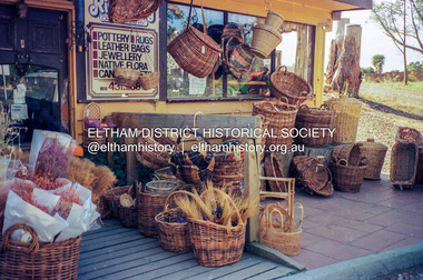
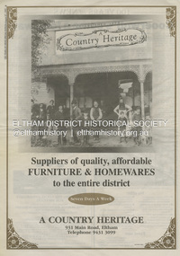
... shop about 1955. Electoral Roll records for 1967 record Raymond Charles Staff at 929 Main Road, Eltham, grocer, and in 1968 at Lot 4, Hillcrest Avenue, Eltham, taxi truck operator. Staff’s store appears to have occupied 929-933 Main Road and the Eltham Big Star Food Centre was centred around 931 Main Road. It would appear that Ray continued to run the business for approximately two years after the original store was demolished...shop about 1955. Electoral Roll records for 1967 record Raymond Charles Staff at 929 Main Road, Eltham, grocer, and in 1968 at Lot 4, Hillcrest Avenue, Eltham, taxi truck operator. Staff’s store appears to have occupied 929-933 Main Road and the Eltham Big Star Food Centre was centred around 931 Main Road. It would appear that Ray continued to run the business for approximately two years after the original store was demolished ...Present day location of Nongkhai Thai Eltham restaurant Formerly the location of: Luther Haleys Bakery and General Store (Sep 1902-1917) - Hayley built this store, which was the first store erected in the present-day Eltham shopping district Hannah Lloyd's General Store (1917-c.Feb 1920) Various owners Staff's General Store (c.1939-Feb 1965) then demolished Ray Staff Eltham Big Star Food Centre (c.1965-1967) Eltham Big Star Food Centre (Staffs new building c.1965-1967) A Country Heritage Furniture and Homewares (?-2006) Newspaper advertisement: Leader Associated Newspapers, 100 Years of News Special Edition, August 27, 1997, p6; A Country Heritage Newspaper advertisement: Diamond Valley Leader, 4 September 2006, Closing Down Sale, A Country Heritage In February 1965, Staffs Railway Store, the oldest business premises in the Eltham shopping district was demolished. Formerly a self-service grocery, restaurant and electrical repair shop, the building for many years housed Eltham’s only ‘family’ grocer and feed store. Earlier it had appeared to have been the town’s bakery. The building had been purchased in late March 1939 by Mr Eric N. Staff. At the time of E.N. Staff’s purchase there were huge bakers’ ovens located at the rear and the building also had a well and four toilets for employees. When the ‘pictures’ came to Eltham with the opening of the Eltham Public Hall across the road in 1941, Mr E.N. Staff extended the business and opened a milk bar and sweet shop. Further extensions re-established the tea rooms of days gone by. Mr E.N. Staff conducted business for about 15 years before handing over the reins to his son, Ray Staff. When his son Ray took over, the milk bar and tea rooms were closed for several years but the milk bar and was later re-opened and subsequently became a greengrocers and later again, a restaurant. The tea rooms section was converted to an electrical repair shop about 1955. Electoral Roll records for 1967 record Raymond Charles Staff at 929 Main Road, Eltham, grocer, and in 1968 at Lot 4, Hillcrest Avenue, Eltham, taxi truck operator. Staff’s store appears to have occupied 929-933 Main Road and the Eltham Big Star Food Centre was centred around 931 Main Road. It would appear that Ray continued to run the business for approximately two years after the original store was demolished and a new supermarket was built. Today, 931 Main Road is the Nongkhai Thai Restaurant and is precisely where the original Staffs store stood. Even though the facade has been modified at eye level with new larger windows, the upper facade is identical to that of the new Eltham Big Star Food Centre of 1965/66. But how did the original building, the oldest premises in the 1965 era shopping centre come about? On August 12th, 1902 at the Eltham Courthouse, appearing before T. Smallman, Esq,. Police Magistrate, and Messrs. W. Duncan and W.J. Taylor, Justices of the Peace is Luther Haley, baker. Wilfred Henry Johnston, by his agent Stanley Ernest Elder had applied for a warrant of ejectment under the Landlord and Tenant Act 1890 against Luther Haley from the bakery premises at the corner of Main Road and York Street. From the evidence presented we learn that Mrs Burgoyne of Eltham had purchased the property some months earlier from Mr Johnston, which consisted of a store and bakery establishment at Eltham occupied by Mr. Luther Haley, and whose lease expired some little time back, and up to the present time, Mr. Haley was not prepared to leave. He informed the court that he is unable to secure at Eltham a suitable house in which to carry on his business, but was building a place near the railway station which he expected to be done in about three weeks time, and he is then prepared to give up possession of the premises he now occupies. Mr Smallman informed the defendant, Luther Haley, that he will have to quit the premises in three weeks from the present date, and that a warrant of ejectment would be issued. However he also informed Mr Haley that he would order the warrant to lie in the office for three weeks from that date. The premises under construction referred to by Luther Haley in court were situated on the western side of Main Road, near the railway station slightly opposite present-day Arthur Street. It was opened around September 1902 as a General Store, Bakery and Tea Rooms. This was the original building in the present-day shopping precinct. At the time the only thing nearby was the railway station. Luther Haley’s business appeared to prosper and he would have catered to not only the locals abut also day visitors by train on Sundays coming up from Melbourne, offering fresh baked produce, tea rooms and summer drinks. The fields across Main Road running between present day Arthur Street and Luck Street were known as Haley’s Paddock and at times were used for community festivities and picnics. A newspaper report on the annual State schools picnic held at Haley’s Paddock on March 11, 1904 described it as “quite close to the railway station, and is quite capable of holding comfortably 10,000 people. With its ample shade and hilly surroundings, it is an ideal place for any gathering.” Luther Haley successfully ran his general store, bakery and tea rooms until 1917 when he and his family departed the district and moved to Westgarth Street in Northcote where he changed careers and became a publisher. It was then taken over by Hannah Lloyd and became known as Lloyd’s Railway General Store from 1917 to 1920. From then it had a succession of owners, one as short as two months until March 31, 1939 when the Grocery Business formerly carried on by Mr. T.K. White of Eltham for the previous eight years was purchased by Mr Eric N. Staff of Research and became known as E.N. Staff’s Railway Store. The ownership timeline for the store is as follows: Luther Haley Sep 1902-1917 Hannah Lloyd 1917-c.Feb 1920 Messrs J.R. & N.E. Lee 1920-Sep 1922 A. & E. Copeland Sep 1922-Sep 1925 Mr Price Sep 1925-Nov 1925 Mr Warren Nov 1925?-Nov 1926 A.W.J. Edwards Nov 1926-1931 T.K. White 1931-Mar 1939 Eric Staff Apr 1939-c.1954 Ray Staff c.1954-Feb 1965 then demolished Ray Staff Eltham Big Star Food Centre c.1965-1967 THROWBACKTHURSDAY: ELTHAM BIG STAR FOOD CENTRE, MAIN ROAD, 1966 https://elthamhistory.wordpress.com/2020/04/16/throwbackthursday-eltham-big-star-food-centre-main-road-1966/eltham, businesses, a country heritage, property, shops, main road eltham, a. copeland, a.w.j. edwards, big star food centre, e. copeland, eric staff, general store, hannah lloyd, j.r. lee, lloyd's general store, luther haley, n.e. lee, price, ray staff, staffs general store, supermarket, t.k. white -
 Eltham District Historical Society Inc
Photograph, Jim Connor, Eltham - Montmorency Uniting Church, 810 Main Rd, Eltham, 10 July 2023
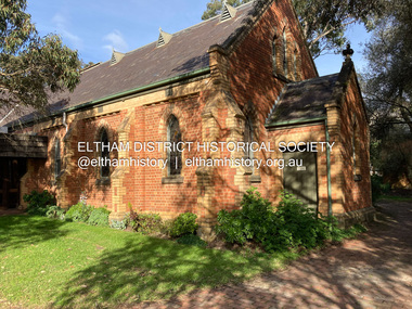
... It is understood that the historic church and the hall will be retained, and the building added in 1971 is to be demolished, to make way for a new purpose-built Opportunity shop. The proposed areas to be demolished include the current foyer, toilets, crèche, etc, including the area between the hall and the former RSL. ...It is understood that the historic church and the hall will be retained, and the building added in 1971 is to be demolished, to make way for a new purpose-built Opportunity shop. The proposed areas to be demolished include the current foyer, toilets, crèche, etc, including the area between the hall and the former RSL. ...Located on the corner of Main Road and John Street, the church first served the community as the Eltham Wesleyan Church since 1881. It became the Eltham Methodist Church in 1902, the year it united with the Primitive Methodists. Eltham Wesleyans first worshipped together in the home of William and Mary Crozier, on 24 acres bounded by Mount Pleasant Road and Pitt Street. From there they moved to a slab and bark hut in 1855 (this later served as the first school run by David Clark prior to the building of a new school in Dalton Street) and the members then built a chapel in 1858 on Lot 20, Henry Street (later to become the Rechabite Hall and Eltham Public Hall). The present church on John Street was designed by architects Crouch and Wilson in the Early English Gothic style with biochrome brick window frames, buttress heads and pinnacle. Church member George Stebbing built the church, the foundations were constructed with stone from the walls of the first Eltham State Primary School (No. 209) building which collapsed in 1874 and were purchased by Robert David Taylor. Stebbing was also responsible for building St Margaret’s Church and Shillinglaw Cottage. The Roll of Honour, which presently hangs in the church hall (which also doubles as the Opportunity Shop) lists 27 members of the congregation who served in the First World War, 11 of whom never returned. The red-brick Church Hall was opened in 1931 and in 1971 further additions linked the hall and church, including a foyer, vestry, meeting room and toilets reflecting the Eltham style of that time with its simplicity, extensive clear glass, reused baked clay-bricks from the 1881 church, heavy ceiling beams and compressed straw ceiling. On June 26, 1977, the church became part of the new Uniting Church in Australia consisting of the former Methodist and Congregational and most of the Presbyterian Churches. Following of declining numbers of worshippers, the church merged with the Montmorency Uniting Church on June 23, 1996. In 2023 the Uniting church approved a plan to renovate the church. It is understood that the historic church and the hall will be retained, and the building added in 1971 is to be demolished, to make way for a new purpose-built Opportunity shop. The proposed areas to be demolished include the current foyer, toilets, crèche, etc, including the area between the hall and the former RSL. Works are expected to commence mid to late July 2023. The Society was invited by a church member to take photographs of these areas to document them prior to demolition works commencing. Ref: “Nillumbik Now and Then” by Marguerite Marshall (2008)jim connor collection, 2023-07-10, eltham-montmorency uniting church, john street, methodist church, opportunity shop, uniting church, uniting church hall -
 Eltham District Historical Society Inc
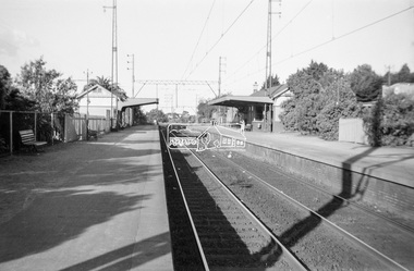
Photograph, George Coop, Mont Albert Railway Station, c.1956
... shops just visible on right of image. The grass embankment visible in the distance on the left of the track is from where another view looking down the track beside Churchill Street was taken. Shows the original building on the northern platform of the Mont Albert station. The railway line was extended out to Lilydale with work commencing in 1882. Mont Albert station opened in 1890. It is presumed that this building was demolished...shops just visible on right of image. The grass embankment visible in the distance on the left of the track is from where another view looking down the track beside Churchill Street was taken. Shows the original building on the northern platform of the Mont Albert station. The railway line was extended out to Lilydale with work commencing in 1882. Mont Albert station opened in 1890. It is presumed that this building was demolished ...Churchill Street shops just visible on right of image. The grass embankment visible in the distance on the left of the track is from where another view looking down the track beside Churchill Street was taken. Shows the original building on the northern platform of the Mont Albert station. The railway line was extended out to Lilydale with work commencing in 1882. Mont Albert station opened in 1890. It is presumed that this building was demolished when the third line was constructed in 1971. At the same time the nearby Surrey Hills original station buildings were demolished. George noted that he had donated a black and white print copy of this image some years earlier to the Surrey Hills Historical Society - see SHP2018/21/6 https://victoriancollections.net.au/items/5d6a450a21ea670e188d05c9Digital TIFF file Scan of Kopdak 620 black and white negative transparencygeorge coop collection, churchill street, mont albert railway station