Showing 99 items matching "diamond hill area"
-
 Bendigo Historical Society Inc.
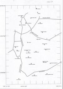
Map - DIAMOND HILL AREA
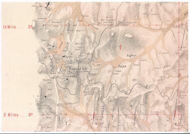
... DIAMOND HILL AREA...Copy of map of Diamond Hill area, with the Trig Station mid centre on map. ...Shafts, mines and geological features are marked. Map DIAMOND HILL AREA ...Copy of map of Diamond Hill area, with the Trig Station mid centre on map. Shafts, mines and geological features are marked.bendigo, mining, diamond hill -
 Bendigo Historical Society Inc.
Document - Kangaroo Flat Gold Mine Collection: Diamond Hill Historic Area, Department of Conservation and Environment, April 1991
... Kangaroo Flat Gold Mine Collection: Diamond Hill Historic Area...Diamond Hill was a gold mining village 5 km south of Bendigo and about 1 km west of the Spring Gully Reservoir. Its location is now inaccessible and within the water catchment area. ...One page double sided information sheet, produced by Department of Conservation and Environment, April 1991, detailing the mining history of the Diamond Hill area, Kangaroo Flat/Spring Gully area. ...On the back of the sheet: map of the Diamond Hill historic area, showing location of former mining sites. ...Diamond Hill was a gold mining village 5 km south of Bendigo and about 1 km west of the Spring Gully Reservoir. Its location is now inaccessible and within the water catchment area. Diamond Hill was reputedly named after a diamond shaped rock on the hill. With the development of mining companies which employed workers with families, a school was needed by 1873 and one was opened at the beginning of the next year. The mining companies included Great Comet Quartz Mining, Golden Fleece Quartz Mining, Albert Tribute, Glasgow Golconda, and Albert Gold Mining and Crushing. Mining continued beyond 1900, as recorded in the Australian handbook, 1903. The Bendigo Mining N.L. company was located nearby, adjoining Ham Street. One page double sided information sheet, produced by Department of Conservation and Environment, April 1991, detailing the mining history of the Diamond Hill area, Kangaroo Flat/Spring Gully area. On the back of the sheet: map of the Diamond Hill historic area, showing location of former mining sites. bendigo mining n.l., bendigo, mining, gold, city of greater bendigo, great comet quartz mining, golden fleece quartz mining, albert tribute, glasgow golconda, albert gold mining and crushing, golden gully, dead dog gully, german miners, british new chum, south golden carshalton, hansel mundy, morning light, mullock tailings, stamp battery, -
 Bendigo Historical Society Inc.
Document - DIAMOND HILL AREA MAP
... DIAMOND HILL AREA MAP...Document DIAMOND HILL AREA MAP ...Map copy, 2 pages, from 'Old Mines Department Plan, Dept of Conservation and Environment File No W91006, 16.6.1972' Map shows Golden Gully area with 'Town and Country Hotel' on north side and further south, with shafts and mine names marked.bendigo, mining, diamond hill -
 Bendigo Historical Society Inc.
Document - DIAMOND HILL HISTORIC AREA PARKS VICTORIA
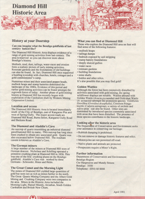
... DIAMOND HILL HISTORIC AREA PARKS VICTORIA...Document, two pages, prepared by Parks Victoria in relation to the Diamond Hill Historic Area. Contains information regarding the history of the area; German Miners; Plants and animals. ...History House 11 Mackenzie Street Bendigo goldfields BENDIGO Mining diamond hill Document, two pages, prepared by Parks Victoria in relation to the Diamond Hill Historic Area. ...Document, two pages, prepared by Parks Victoria in relation to the Diamond Hill Historic Area. Contains information regarding the history of the area; German Miners; Plants and animals. On second page is a map of the area showing historic features: Deborah Consolidated Gold workings Red, White and Blue Extended gold workings Goldfields Extended gold workings Dead Dog Gully, alluvial gold workings Glasgow & Golconda Gold workings and tramway Surface gold mining site Hansel Mundy gold workings Bendigo Goldfields Pty gold workings Stafford gold workings Langdon gold workings Great Opossum Gully alluvial gold workingsbendigo, mining, diamond hill -
 Bendigo Historical Society Inc.
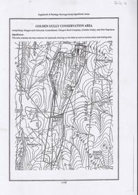
Document - DIAMOND HILL, GOLDEN GULLY COSERVATION AREA
... DIAMOND HILL, GOLDEN GULLY COSERVATION AREA...The area is significant because it contains the 'best evidence for hydraulic sluicing on the field as well as several early reef mining sites' On top of page 'Eaglehawk & Bendigo Heritage Study, Significant areas' Mines marked on page: Goldfields Extended shaft South Concord shaft Concord shaft Morning Light shaft Hansel and Mundy shaft Document DIAMOND HILL, GOLDEN GULLY COSERVATION AREA ...Map of Golden Gully conservation area comprising Glasgow and Golconda Consolidated, Glasgow Reef Company (Golden Gully) and New Napoleon. The area is significant because it contains the 'best evidence for hydraulic sluicing on the field as well as several early reef mining sites' On top of page 'Eaglehawk & Bendigo Heritage Study, Significant areas' Mines marked on page: Goldfields Extended shaft South Concord shaft Concord shaft Morning Light shaft Hansel and Mundy shaftbendigo, mining, golden gully -
 Bendigo Historical Society Inc.
Document - COMMUNITY LIFE
... Typed notes mentioning Diamond Hill area, advertisements in the three local papers and further sources for research....History House 11 Mackenzie Street Bendigo goldfields DOCUMENT Newspaper Community Life Bendigo Advertiser Sandhurst Bee Bendigo Independent Typed notes mentioning Diamond Hill area, advertisements in the three local papers and further sources for research. ...Typed notes mentioning Diamond Hill area, advertisements in the three local papers and further sources for research.document, newspaper, community life, bendigo advertiser, sandhurst bee, bendigo independent -
 Bendigo Historical Society Inc.
Document - DIAMOND HILL 1920 RESIDENTS
... ...diamond hill area...History House 11 Mackenzie Street Bendigo goldfields BENDIGO Gold mining diamond hill area Typed and handwritten document detailing the Diamond Hill residents in the 1920. ...Typed and handwritten document detailing the Diamond Hill residents in the 1920. Author unknown. Names of residents: Dempster Bush Herbel, Miss Rose ( Mrs Luke Murphy) Dean, Herman Holidays (Hollidays?) 3 families Eddy, Redfern (family) Wescloh, Mrs. Augusta (postmistress) Mrs Day Schilling, Roy Ruschmeyer Residents 1981 Bush Ruschmeyer Old Post Officebendigo, gold mining, diamond hill area -
 Bendigo Historical Society Inc.
Newspaper - JACK PERRY COLLECTION: NEWSPAPER DIAMOND HILL GOLDEN GULLY
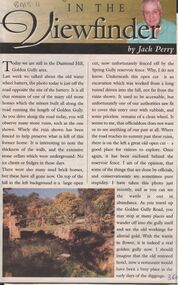
... Newspaper article, Bendigo Weekly, re Diamond Hill area, including Golden Gully. . Mentions the mine sites, extensive mud brick home ruins, stone cellars that can be found in the area....History House 11 Mackenzie Street Bendigo goldfields PERSON Individual jack perry - diamond hill Golden Gully Diamond Hill mudbrick Newspaper article, Bendigo Weekly, re Diamond Hill area, including Golden Gully. . ...Newspaper article, Bendigo Weekly, re Diamond Hill area, including Golden Gully. . Mentions the mine sites, extensive mud brick home ruins, stone cellars that can be found in the area.person, individual, jack perry - diamond hill, golden gully, diamond hill, mudbrick -
 Bendigo Historical Society Inc.
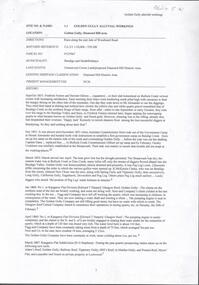
Document - CENTRAL DEBORAH GOLD MINE : GOLDEN SQUARE MINE SITES
... Map showing mines in the Golden Square, Diamond Hill area. Roads include Diamond Hill Road, Burns Street, Woodward Road, Belle Vue Road, Houston Street. ...History House 11 Mackenzie Street Bendigo goldfields BENDIGO Mining golden square mine sites Map showing mines in the Golden Square, Diamond Hill area. Roads include Diamond Hill Road, Burns Street, Woodward Road, Belle Vue Road, Houston Street. ...Map showing mines in the Golden Square, Diamond Hill area. Roads include Diamond Hill Road, Burns Street, Woodward Road, Belle Vue Road, Houston Street. Latitude and Longitude on map.bendigo, mining, golden square mine sites -
 Bendigo Historical Society Inc.
Document - GOLDEN GULLY ALLUVIAL WORKINGS
... Golden Gully alluvial workings, Diamond Hill area, site number 1.1. Document has map/grid references, parcel number and location - runs along Woodward Road. ...History House 11 Mackenzie Street Bendigo goldfields Golden Gully alluvial workings, Diamond Hill area, site number 1.1. Document has map/grid references, parcel number and location - runs along Woodward Road. ...Golden Gully alluvial workings, Diamond Hill area, site number 1.1. Document has map/grid references, parcel number and location - runs along Woodward Road. History from 1851 to 186 detailed. . Information from David Bannear's Bendigo goldfields survey. -
 Bendigo Historical Society Inc.
Document - PETER ELLIS COLLECTION: NOTES MENTIONING WHIPSTICK REGION
... Four pages of typed notes mentioning the Whipstick Region, Mandurang Forest, Jackass Flat, Diamond Hill Area, One Tree Hill, and the Coliban/Sandhurst Water Supply Reserve. ...Region Bendigo Block Bendigo Field Naturalists Club Shipstick Scrub Mandurang Forest One Tree Hill Public park Redvers J Eddy Coliban/Sandhurst Water Supply Reserve Four pages of typed notes mentioning the Whipstick Region, Mandurang Forest, Jackass Flat, Diamond Hill Area, One Tree Hill, and the Coliban/Sandhurst Water Supply Reserve. ...Four pages of typed notes mentioning the Whipstick Region, Mandurang Forest, Jackass Flat, Diamond Hill Area, One Tree Hill, and the Coliban/Sandhurst Water Supply Reserve. Mentioned are the Birds, Mammals, Geology, Flora, Ground Flora, Orchids,Lilies, Mistletoe, Ferns and Grasses of some of the areas.bendigo, parks and gardens, public reserves, peter ellis collection, north/central l.c.c. region bendigo block, bendigo field naturalists club, shipstick scrub, mandurang forest, one tree hill public park, redvers j eddy, coliban/sandhurst water supply reserve -
 Bendigo Historical Society Inc.
Document - OPOSSUM GULLLY ALLUVIAL WORKING, DIAMOND HILL
... One page document detailing location and description of physical mining remains in Opossum Gully, Diamond Hill Historic area....History House 11 Mackenzie Street Bendigo goldfields BENDIGO Mining opossum gully One page document detailing location and description of physical mining remains in Opossum Gully, Diamond Hill Historic area. Document OPOSSUM GULLLY ALLUVIAL WORKING, DIAMOND HILL ...One page document detailing location and description of physical mining remains in Opossum Gully, Diamond Hill Historic area.bendigo, mining, opossum gully -
 Bendigo Historical Society Inc.
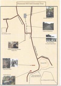
Document - DIAMOND HILL SELF GUIDED TOUR
... One page coloured map of historical sites in the Diamond Hill area. Including the Golconda Battery site, Tramway Embankment, site of former Town and Country Hotel, Sandhurst Municipal Boundary Marker Post, Waterwheel Cutting, Stafford Mine site. ...History House 11 Mackenzie Street Bendigo goldfields BENDIGO Tourism diamond hill One page coloured map of historical sites in the Diamond Hill area. ...One page coloured map of historical sites in the Diamond Hill area. Including the Golconda Battery site, Tramway Embankment, site of former Town and Country Hotel, Sandhurst Municipal Boundary Marker Post, Waterwheel Cutting, Stafford Mine site. On the back a description of the various sites. Produced by the Bendigo Historical Societybendigo, tourism, diamond hill -
 Bendigo Historical Society Inc.
Newspaper - Article about a mystery sign found in Bendigo bushland, Wed May 27 2020
... Terry Davidson found the star in plain sight in the Diamond Hill historical area near Kangaroo Flat, Golden Square and Spring Gully....History House 11 Mackenzie Street Bendigo goldfields Terry Davidson found the star in plain sight in the Diamond Hill historical area near Kangaroo Flat, Golden Square and Spring Gully. bendigo mystery star terry davidson Bendigo Advertiser: Story entitled 'Help Solve this History Mystery', about a star-shaped metal sign. ...Terry Davidson found the star in plain sight in the Diamond Hill historical area near Kangaroo Flat, Golden Square and Spring Gully.Bendigo Advertiser: Story entitled 'Help Solve this History Mystery', about a star-shaped metal sign. bendigo mystery star, terry davidson -
 Bendigo Historical Society Inc.
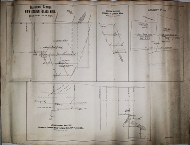
Plan - New Golden Fleece and Herbel Comet Gold Mines, W.H. Cundy, Mining Engineer, 27th September, 1910
... The Herbel Comet Mine and the New Golden Fleece Gold Mine were situated in the Diamond Hill area. In 1912, (19th September) the 'Bendigo Advertiser' reported that Mr. ...History House 11 Mackenzie Street Bendigo goldfields The Herbel Comet Mine and the New Golden Fleece Gold Mine were situated in the Diamond Hill area. In 1912, (19th September) the 'Bendigo Advertiser' reported that Mr. ...The Herbel Comet Mine and the New Golden Fleece Gold Mine were situated in the Diamond Hill area. In 1912, (19th September) the 'Bendigo Advertiser' reported that Mr. Rankin had an option to purchase the Herbel Comet mine, which adjoined the New Golden Fleece Mine on the south side. The mine had a 'handy winding plant and a ten head battery'. See report by W.H. Cundy on the mine, 20th September, Bendigo Advertiser: https://trove.nla.gov.au/newspaper/article/226959415?searchTerm=herbels%20comet%20mine White paper plan, black text, written on top of plan: transverse section, New Golden Fleece Mine, 80' to an inch and cross-section Herbels Comet Mine. On bottom of plan: 'Longitudinal section Herbels Comet Mine to New Golden Fleece Gold Mine'. Plan forms part of the Margaret Roberts Collection.W.H. Cundy, 27.9.1910gold mining, gold, bendigo, herbels comet mine, golden fleece gold mine, new golden fleece gold mine, diamond hill, w.h. cundy -
 Bendigo Historical Society Inc.
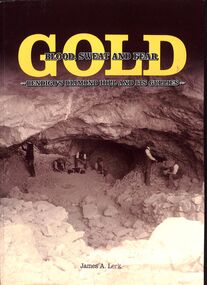
Book - "Gold. Blood, sweat and fear. Bendigo's Diamond Hill and its gullies", 2002
... Diamond Hill forms part of the southern part of Bendigo goldfields. Diamond Hill was a gold mining village 5 km south of Bendigo and about 1 km west of the Spring Gully Reservoir. Its location is now in the water catchment area...Diamond Hill forms part of the southern part of Bendigo goldfields. Diamond Hill was a gold mining village 5 km south of Bendigo and about 1 km west of the Spring Gully Reservoir. Its location is now in the water catchment area ...Bendigo's Diamond Hill forms part of the southern part of Bendigo goldfields. Diamond Hill was a gold mining village 5 km south of Bendigo and about 1 km west of the Spring Gully Reservoir. Its location is now in the water catchment area. Diamond Hill was reputedly named after a diamond shaped rock on the hill. With the development of mining companies which employed workers with families, a school was needed by 1873 and one was opened at the beginning of the next year. The mining companies included Great Comet Quartz Mining, Golden Fleece Quartz Mining, Albert Tribute and Albert Gold Mining and Crushing. Mining continued beyond 1900. This book discusses history of the area from Dream Time to first European contact, focusing on the associated mining in the area. "Gold. Blood, Sweat and Fear. Bendigo's Diamond Hill and its gullies" by James A Lerk. Published in by JA and ERS Lerk. Published in 2016. Soft cover book. Front cover has sepia image of miners in mine. Back cover is black with assortment of handwritten documents/invoices. Title written in gold and dark brown. Title also on spine. Printed in Bendigo, Australia. 252 pp. Folded Bendigo map folded inside back cover. Contains both text and black and white images. Has index. gold, diamond hill, miners, mining -
 Kiewa Valley Historical Society
Photograph - Folder of Photographs – Photocopied set of black and white photographs (pages 9 - 18) from the display folder put together by KVHS to document life on the Kiewa Valley Hydro-electric Scheme
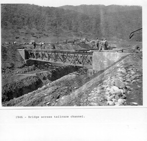
... Mount Beauty, and to a lesser extent Bogong, are among these places. secv; kiewa hydro electric scheme; mt beauty; bogong; construction area 1-1946 – Bridge across tailrace channel Page number 9 2-New mess building, Mt Beauty 6.4.46 Page number 10 3- STATE ELECTRICITY COMMISSION OF VICTORIA Date: 10.1.47 Time: 11.40am No K2271 Kiewa Hydro Electric Works Homan’s Gap Saw Mill – Rip Saw Page number 11 4- STATE ELECTRICITY COMMISSION OF VICTORIA Date: 5.10.47 Time: 11am No K4111 Kiewa Hydro Electric Works Diamond Drilling Plant – Big Hill Page number 12 5- STATE ELECTRICITY COMMISSION OF VICTORIA Date: 11.2.48 Time: 3pm No K4277 Kiewa Hydro Electric Works Rocky Valley Camp-Mess Building Page number 13 6- STATE ELECTRICITY COMMISSION OF VICTORIA Date: 15.4.48 Time: 4.30pm No K4397 Kiewa Hydro Electric Works Parlimentary Party at Rocky Valley Page number 14 7- STATE ELECTRICITY COMMISSION OF VICTORIA Date: 22.8.48 Time: 9am No K4668 Kiewa Hydro Electric Works General view of No.4 Headrace Tunnel Page number 15 8-STATE ELECTRICITY COMMISSION OF VICTORIA Date: 5.9.49 Time: 10am No K5180 Kiewa Hydro Electric Works Allis-Chalmers Tractor School – HD 19, Mr I Crossthwaite at Controls Page number 16 9- No markings Page number 17 10- STATE ELECTRICITY COMMISSION OF VICTORIA Date: 7,12.49 Time: 4pm No K5423 Kiewa Hydro Electric Works No. 5 Raceline – Balasting Track with improvised truck. ...Although the Kiewa Hydro-Electric Scheme was first proposed in 1911, construction did not commence until 1938. As part of the push to cut electricity costs and diversify supply, the Victorian Government (circa 1930) initiated the conversion from primarily brown coal supply to hydro – electricity. Field investigations during the 1940’s resulted in a new proposal for a scheme that had more than double the capacity of the 1938 scheme. The Kiewa Hydroelectric Scheme became the largest scheme of its kind in the State Of Victoria and the second largest scheme in Australia. The number of personnel involved in the planning and construction of the scheme increased dramatically. During the late 1940’s, most activity centred around the construction of the West Kiewa Power Station, Rocky Valley Reservoir, McKay Creek Power Station and the Bogong Creek Aqueduct.A common thread across all the larger hydro scheme constructions was the need for workers, both qualified and unqualified who came from around the world seeking a new life for themselves and their families. New accommodation and facilities were required for the army of workers engaged in construction in often remote and wild areas. The SEC had a high demand for timber, and set up the first of a number of sawmills at Bogong Creek in 1939 and set up the first hardwood logging in the headwaters of the Kiewa River. These new ‘towns’ such as Mt Beauty and Bogong, survived, serving the needs of operational personnel and their families, and expanding with growth of new industries. Mount Beauty, and to a lesser extent Bogong, are among these places. PHYSICAL: Large A3 size spiral bound display folder containing 21 pages of photocopied black and white photographs of various aspects of the early days of the Kiewa Valley Hydro-electric scheme including equipment, various work sites and photographs of workers and their families. 1-Bridge across Tailrace Channel 1946 2-New Mess building, Mt Beauty 3-Homan’s Gap Saw Mill 4- Diamond Drilling Plant – Big Hill 5-Rocky Valley Camp-Mess Building 6-Parlimentary Party at Rocky Valley 7-No.4 Headrace Tunnel 8- Allis-Chalmers Tractor School 9- SECV Heavy Machinery lined up by road 10- No. 5 Raceline – Balasting Track with improvised truck 1-1946 – Bridge across tailrace channel Page number 9 2-New mess building, Mt Beauty 6.4.46 Page number 10 3- STATE ELECTRICITY COMMISSION OF VICTORIA Date: 10.1.47 Time: 11.40am No K2271 Kiewa Hydro Electric Works Homan’s Gap Saw Mill – Rip Saw Page number 11 4- STATE ELECTRICITY COMMISSION OF VICTORIA Date: 5.10.47 Time: 11am No K4111 Kiewa Hydro Electric Works Diamond Drilling Plant – Big Hill Page number 12 5- STATE ELECTRICITY COMMISSION OF VICTORIA Date: 11.2.48 Time: 3pm No K4277 Kiewa Hydro Electric Works Rocky Valley Camp-Mess Building Page number 13 6- STATE ELECTRICITY COMMISSION OF VICTORIA Date: 15.4.48 Time: 4.30pm No K4397 Kiewa Hydro Electric Works Parlimentary Party at Rocky Valley Page number 14 7- STATE ELECTRICITY COMMISSION OF VICTORIA Date: 22.8.48 Time: 9am No K4668 Kiewa Hydro Electric Works General view of No.4 Headrace Tunnel Page number 15 8-STATE ELECTRICITY COMMISSION OF VICTORIA Date: 5.9.49 Time: 10am No K5180 Kiewa Hydro Electric Works Allis-Chalmers Tractor School – HD 19, Mr I Crossthwaite at Controls Page number 16 9- No markings Page number 17 10- STATE ELECTRICITY COMMISSION OF VICTORIA Date: 7,12.49 Time: 4pm No K5423 Kiewa Hydro Electric Works No. 5 Raceline – Balasting Track with improvised truck. Page number 18 secv; kiewa hydro electric scheme; mt beauty; bogong; construction area -
 Eltham District Historical Society Inc
Film - Video (VHS), Diamond Creek Fire Brigade, c.1955-1987
... Hill in 1981. Still photo scenes of ex Captain Clarrie Stone, Brigade Captain for 21 years; ex Captain Jack Marks, 10 years; ex Captain Ian Douglas, 10 years. Cuts to scene of radio control room, January 1969, and news of a fire on the northern side of the township of Diamond Creek. With scenes of flames in bush, the narration explains that until the early 1960s the area...Hill in 1981. Still photo scenes of ex Captain Clarrie Stone, Brigade Captain for 21 years; ex Captain Jack Marks, 10 years; ex Captain Ian Douglas, 10 years. Cuts to scene of radio control room, January 1969, and news of a fire on the northern side of the township of Diamond Creek. With scenes of flames in bush, the narration explains that until the early 1960s the area ...Combination of three movie films. Movie One (1950s): 00:00 – 13:14 Black and white footage of Diamond Creek firemen practising in Diamond Street in the 1950s for forthcoming demonstrations of abilities. Mentions of Gordon Brandy and Joe Hislop Running out hoses from old hose reels along Diamond Street, Diamond Creek Displays from various brigades running out and connecting hoses. Also scenes from the 1950s of Diamond Creek Fire Brigade competing in various locations around Victoria and Tasmania. Mentions of Brigade members Dave Kidd, Bruce Hackett, Ron Kirkbride, Jack Marks, Graham Upton who are prominent in these events. Members of Kyneton Fire Brigade also present. Members competing in running out hose reels, connecting hoses togethers and to hydrants then climbing towers to direct water from hose or at a target hanging above the road. Diamond Creek members identified wearing a diamond on their chest and back. Includes scenes of Scottish pipe bands at the events and significant crowds of spectators. Footage of Mel Stone and Beryl Marks, Stan Redpath and Ron Kirkbride, then Ron Kirkbride and Eric Holt viewing flower displays. Film changes to colour at Diamond Creek oval for practice with fire engine entering oval. Members depicted include Bill May, Jack Sinclair, Jim Cox, Bob Beale, Dave Kidd, Bruce Hackett and Captain Clarrie Stone. Reverts to black and white in the 1950s where the Brigade joins forces with the Diamond Valley Community Hospital for a Gala Day on the Diamond Creek Oval. Changes to colour again, possibly same event and scenes of children on bikes and scooters or with prams and carts racing around the oval. Mention of young lad Brian Laurie who has his own fire truck. Dart throwing, pony rides. Scenes with Dr Don Cordner, Gus Lyons, Vic Cohn (?) and spinning wheel and Diamond Creek School children entertain a large crowd with Maypole dancing. Movie Two (1950s): 13:25 – 19:00 This black and white film was taken by a TV film crew in the 1950s depicts a typical call out for the Diamond Creek Fire Brigade. In this case the careless action of a member of the public throwing a lighted match from a car, which can cause extensive damage. Footage features the Shire of Eltham War Memorial tower at Kangaroo Ground before it was modified with a fire spotter’s cabin. Discusses fire spotting operations from the tower. Shows a fire spotter walking around the top of the tower. A fire is detected, and the information is relayed to the nearest fire station, in this case, Diamond Creek. The telephone call is received, and the alarm sounded. Captain Clarrie Stone and firemen May and Shaw leave their workplaces and prepare for action. Scenes of running across the Main Hurstbridge road showing the shops (Shell service station and Chemist prominent). Scenes entering the fire station which has a pictorial warning covering the entire door “Only you can prevent forest fires – If you’re careless – we’re homeless!” Eric Holt pinpoints the location of the fire while Captain Clarrie Stone and Fireman Shaw take note. The advance vehicle (an FE Holden ute, rego GTE-696) leaves to assess the extent of the fire. Having assessed the fire, Fireman Shaw communicates with base showing radio with call sign VL3JZ. Eric Holt takes the call. In the meantime, Captain Clarrie Stone and Fireman Shaw undertake some limited action to address the fire. Firemen Bill May, Jim Bates and Hugh Bar (?) man the tanker. A photo portrait of Queen Elizabeth is visible hanging on the wall. They are later joined by Firemen Jim Cox, Eric DeBuse (?) and Jack Marks. The tanker is seen departing the station and diverging off before the bridge. Captain Clarrie Stone and Fireman Shaw are seen pumping water on the flames with hand pumps when the tanker arrives. The hose is unreeled, and water turned on the flames. Jack Sinclair joins the action. Jim Cox directs water to the high stuff. The fire put out, Jack Marks and Eric DeBuse wind in the hoses and the team head back to town. It’s peaceful again at the memorial tower. Movie Three (1969-1987): 19:14 – 34:34 Colour film “Fired with Dedication”, Country Fire Authority Victoria, produced by I.L. Wadeson, Commentary by A.M. Hem. Credits with CFA Victoria emblem and then placed over a view of an old-style ladder engine. Opens with the scene of a fire engine outside the Diamond Creek Fire Station then various trophies reflecting the competition success of the brigade in various track and disciplined events. Two trophies shown of particular pride to the brigade were for first place in the Torchlight Procession at the State Championships in Mildura in 1986 and also at Swan Hill in 1981. Still photo scenes of ex Captain Clarrie Stone, Brigade Captain for 21 years; ex Captain Jack Marks, 10 years; ex Captain Ian Douglas, 10 years. Cuts to scene of radio control room, January 1969, and news of a fire on the northern side of the township of Diamond Creek. With scenes of flames in bush, the narration explains that until the early 1960s the area was an orchard district which protected the town against the savagery of bushfires. But due to competition from other areas more suitable for orcharding and easier transport to Melbourne the district could no longer remain competitive, and orchards were replaced by grassed areas, which together with the bush areas were a feeding ground for fire. On 8th January 1969, high temperatures and strong north winds, were, with the carelessness of some individual all that was necessary to produce the worst fire the district had seen. Cuts to scene of blackened fields and cattle - Hundreds of hectares of grass land were blackened, and cattle had to be transported to other areas for agistment. Scene of destroyed buildings in the township – 13 houses and the public hall in the town were destroyed as was the theatre equipment which was owned by the fire brigade. The Church of England Hall and bell tower were badly damaged. The whole town could have been burnt out but for the determination, skill, and courage of the Diamond Creek Fire Brigade. Scenes of all that was left of the home on the hill on the west side of the Church of England. Also, the remains of the old Pisy (?) home on the top of the same hill near Lambert Street, and the ruined Crocker home. Cuts to a scene in the mid-1970s to mid-1980s of a house fire in Haley Street attended by the Diamond Creek Fire Brigade. Although the house was severely damaged, it was saved. Mentions that whilst assistance is appreciated, in some circumstances, those doing so are not properly dressed for fighting fires. Breathing apparatus is a must in structure fire attack. Next scene (either on Mangarook or Coventry oval) showing off four Diamond Creek Fire Brigade efficient and very expensive firefighting units. Features a forward control vehicle Toyota 4WD used for conveying task force personnel to the required areas; a Hino Model 3.2 tanker, diesel powered and carries 3,000 litres of water and has a 16 HP petrol driven pump which delivers 900 litres of water per minute; an International tanker (registration TCM-418) which carries 3,000 litres of water with pumping capacity of 600 litres per minute. The Ford diesel powered pumper (registration MXE-754) is a well-equipped vehicle with a water capacity of 1,000 litres and capable of pumping 1,900 litres of water per minute from the main pump, has many lockers which hose equipment such as breathing apparatus and various types of hose nozzles and foam making equipment. The vehicle carries 360m of 64mm diameter hose which can be laid out from the rear lockers and a portable lighting plant, an Oxy Viva resuscitator to revive smoke inhalation victims and forcible entry tools to gain access to structure fires. Views of the main pump and control panel on the vehicle. As well as the main pump, the vehicle is equipped with an auxiliary pump which allows the facility to pump whilst moving. Fire fighters must undergo constant training and hone their skills, Scenes of a training exercise using the pumper to pump from static water. First, the short lengths of suction hose are coupled, a strainer fitted to ensure debris does not foul the pump. Gauges must be constantly monitored to ensure manageable water pressures are maintained. Pressures are normally controlled to allow two fire fighters to work at each nozzle outlet. Two nozzles are tested, one adjustable jet fog type which is used on flammable gasses or within a structure fire to absorb heat. A straight jet nozzle to project water long distances to protect exposed surfaces close to a fire radiated heat. The pumper is quite a versatile vehicle in handling structure fires, but it also carries specialist equipment needed in containing hazardous chemical incidents. Cuts to scene of parade – the Diamond Creek Fire Brigade has with other neighbouring brigades participated in most town fairs and earns the respect of the watching public. It can be seen why this brigade has been so successful at disciplined contests. Views of Plenty Fire Brigade Road Rescue unit which is equipped with the “Jaws of Life” Scenes of athletic competitions – many neighbouring brigades indulge in friendly but keen competition at the Diamond Creek Town Fair. The young are also encouraged to participate in all aspects of Junior Fire Brigade activities and become tomorrow’s generation of volunteer fire fighters. Scene of the 1986 Diamond Creek Town Fair which was the last time veteran Captain Clarrie Stone BEM marched with the brigade. Clarrie was awarded the British Empire Medal for his service to the Country Fire Authority. Also, scenes of vehicles in the parade. Cuts to scene of brigade members in drill formation for inspection by Acting Chief Harry Rothsay (?) on the occasion of the opening of the new fire station extensions on August 29, 1987. Rudy Libel (?) Captain at the time. Scenes of crowds including many dignitaries of neighbouring brigades present including Lieutenant Gordon Grandy (who came down from Queensland for the occasion) and ex-Secretary David Kidd and wife Betty, also ex Captain Clarrie Stone and Mrs Nel Stone, a life member of the Ladies Auxiliary, the Reverend Jock Ryan, son of J.L Ryan, founder of the Diamond Creek Fire Brigade, Foundation Captain of the fire brigade, Keith Bradbury and Mrs Bradbury. Pauline Dick accepts a community service award for services to the CFA. Recognising over 47 and a half years of service, a presentation is made by Mr Neil Marshall, Acting Chairman of the CFA to ex Captain Clarrie Stone with response by Clarrie. Other members of the official party include Cr. Martin Wright, Shire President Wayne Phillips and local Member of Parliament, Mrs Pauline Toner. Ex foreman John Bennett is presented with a life member’s awards by Captain Rudy Libel. The camera also catches Gwen Cox, Jean Ryan and Bessie Layton (?) Provides historic footage of people, places and equipment and a record of the worst fires expoerienced in Diamond Creek in 1969BASF Standard Quality SQ E-180 VHS dubbing (poor quality) of three films Converted to MP4 file format 0:34:38, 1.85GBOn label: "Donation - August 2000 Diamond Creek Unit Old films made up from Fire Brigade shows at competitions - also Kangaroo Ground Tower being used"video recording, diamond creek fire brigade, 1986 diamond creek town fair, a.m. hem, acting chief harry rothsay, athletic competitions, beryl marks, bessie layton, betty kidd, bill may, bob beale, brian laurie, bruce hackett, captain clarrie stone, chemist, church of england hall, clarrie stone, clarrie stone bem, country fire authority victoria, coventry oval, cr. martin wright, crocker home, dart throwing, dave kidd, david kidd, diamond creek, diamond creek fire station, diamond creek oval, diamond creek school, diamond creek town fair, diamond street, diamond valley community hospital, dr don cordner, eric debuse, eric holt, fe holden ute, fire damage – buildings, fire spotter, fire spotter’s cabin, fire station extension, fired with dedication (film), firefighting units, fireman shaw, firemen jim cox, ford pumper, foundation captain, gala day, gordon brandy, gordon grandy, graham upton, gus lyons, gwen cox, haley street, hino model 3.2 tanker, house fire, i.l. wadeson, ian douglas, international tanker, j.l ryan, jack marks, jack sinclair, january 1969, jaws of life, jean ryan, jim bates and hugh bar, jim cox, joe hislop, john bennett, kangaroo ground, kangaroo ground tower, keith bradbury, kyneton fire brigade, lambert street, main hurstbridge road, mangarook oval, maypole dancing, mel stone, mildura 1986, mrs bradbury, mxe754 vic registration, neil marshall, nel stone, orchard district, oxy viva resuscitator, pauline dick, pauline toner mp, pisy home, plenty fire brigade road rescue unit, pony rides, radio control room, reverend jock ryan, ron kirkbride, rudy libel, shell service station, shire of eltham war memorial, shire president wayne phillips, spinning wheel, stan redpath, state championships, swan hill 1981, tcm418 vic registration, torchlight procession, toyota 4wd, trophies, vic cohn, victorian bushfires - 1969, vl3jz -
 Eltham District Historical Society Inc
Film - Video (VHS), Nillumbik Shire Council, The Nillumbik Story, 1996
... Diamond Valley miniature railway...Doncaster...dunmoochin...Education program...EEPS...Eltham...Eltham East Primary School...Eltham East Primary School Band...Eltham Library Community Gallery...Eltham Lower Park...Environment...fishing...flour mill...fruit growing...fruiterer...Garden Hill...Gold mining...Green Wedge...Greensborough...Heritage Trail...Hurstbridge Railway Line...jazz festival...Jock Ryan...Kangaroo Ground...kangaroo ground tower...Kinglake...Maroondah Aqueduct...Matcham Skipper...Memorial Park...Ming Mackay (1918-2009)...Montsalvat...Mudbrick houses...Music...musicians...nesting area...CREDITS Music by John Greenfield from the CD Sweet Rain “The Snow Tree”, Uncle Music UNC 2001 Cameras - David Mirabella and Peter Farragher Editor – Olwyn Jones Written and Produced by Jason Cameron A Jason Cameron Proction for Nillumbik Shire Provides a record of the relatively newly created Shire of Nillumbik at the time and the features and attactions of the shire in its people arts, culture and environment video recording Arthurs Creek Arthurs Creek Landcare group Artists artists in residence Arts Arts Festival Authors BlackBerry Brock family Bulldozer Bulleen bushland sanctuary Caledonian gold rush Charles Reddington Clifton Pugh cottlesbridge Cypress rows developer Diamond Creek Diamond Creek Mine Diamond Reef Diamond Valley miniature railway Doncaster dunmoochin Education program EEPS Eltham Eltham East Primary School Eltham East Primary School Band Eltham Library Community Gallery Eltham Lower Park Environment fishing flour mill fruit growing fruiterer Garden Hill Gold mining Green Wedge Greensborough Heritage Trail Hurstbridge Railway Line jazz festival Jock Ryan Kangaroo Ground kangaroo ground tower Kinglake Maroondah Aqueduct Matcham Skipper Memorial Park Ming Mackay (1918-2009) Montsalvat Mudbrick houses Music musicians nesting area Nillumbik Historical Society Nillumbik Shire North Warrandyte Old timer Orchards Peter Brock Plenty River poets Population Recreation recreational activities revegetation Robert Hoddle Sandy Brock Shillinglaw Cottage Shire of Eltham War Memorial Sigmund Jorgensen St Andrews Hotel St Andrews Market Sugarloaf Reservoir Templestowe The Hill tourism Viewing platform Warrandyte water catchment area Watsons Creek Wedgetail eagle Whittlesea Wiregrass Gallery Wurundjeri Yarra River Jack Powell VHS Cassette (five copies) DVD (one copy) Converted to MP4 file format 0:22:00, 1.60GB The Nillumbik Story Film Video (VHS) Nillumbik Shire Council Jason Cameron David Mirabella Peter Farragher Olwyn Jones ...PART 1 – NILLUMBIK (00:00-07:17) Opening features various scenes around Nillumbik Shire. For 40,000 years Nillumbik was the home of the Wurundjeri people. Robert Hoddle gave the district its name. Jock Ryan, then president of Nillumbik Historical Society discusses the names Nillumbik and Diamond Creek. In the late 1830s white occupation began with gold found in Warrandyte in 1851 and 12 years later at Diamond Creek -the Diamond Reef which led to the Caledonian gold rush. Jock Ryan discusses the Diamond Creek mine, which was thriving until it burnt out in 1915. Large numbers of workmen moved into area in late 1870s to construct the Maroondah Aqueduct. With growing population of Melbourne, the nearby Yan Yean system had severely disrupted the flow of the Plenty River, forcing the closure of three flour mills there. The aqueduct came to the rescue carrying water 66km from Healesville to Preston. When the Diamond Creek gold mine burnt down the local economy suffered but fruit growing industry had already been established and Diamond Creek became a thriving fruit growing centre. Interview with Jack Powell, a long-time fruiterer at St Andrews market, his family had lived in the area for a hundred years, 3 to 4 generations, “a lot of hard work”. By the time the railway arrived fruit growing was no longer competitive. The railway brought the city closer and day trippers. The Green Wedge separates the shire from the more densely developed neighbours such as Whittlesea, Doncaster, Templestowe, Bulleen and Greensborough. Population at the time (1996) was 19,000 but links to the past remain strong. Mudbrick houses along the Heritage Trail The saving of Shillinglaw Cottage from demolition in 1963 and relocation brick by brick. PART 2 – ENVIRONMENT (07:18-14:44) Peter Brock (with Bev Brock in background) at St Andrews market discusses his childhood growing up in the district and the environment and the values it instilled upon him and his own family. The Brocks have been in the district since the 1860s. Nillumbik Shire responsible for managing three catchment areas; Diamond Creek, Arthurs Creek and Watsons Creek. Follows the course of the Diamond Creek commencing in Kinglake through the district to its confluence with the Yarra River at Eltham at Eltham Lower Park. Highlights Eltham Lower Park community revegetation program and the newly constructed (1996) viewing platform built of new and recycled timbers at the confluence of the Diamond Creek and Yarra River. Also featured are outdoor recreation on the river and at Eltham Lower Park including the Diamond Valley miniature railway. Sugarloaf reservoir and recreational activities and fishing. Aerial view of Memorial Park and Shire of Eltham War Memorial tower at Garden Hill, Kangaroo Ground. Significant tourism opportunities for the shire with 3 million potential day-trippers in metropolitan Melbourne. Council and community working together to find a way to promote the shires natural and artistic assets. At Arthurs Creek, the Brock family and neighbours working together to take care of their waterway. Peter Brock’s uncle, Sandy Brock talks about environmental management and the Arthurs Creek Landcare group and actions to eradicate blackberry problem. Having previously planted Cypress rows they are replacing them with indigenous species to improve the water supply, keeping cattle out of the creek bed to improve the quality downstream flowing into the Yarra. Eltham East Primary School Band playing “All things bright and beautiful” merges into scenes of the bushland sanctuary set aside by the school in 1980 with unidentified teacher discusses the sanctuary and their education program and school children’s comments. Plight of a family of Wedgetail eagles nesting in the path of a developer’s bulldozer at North Warrandyte and actions to save their nesting areas. PART 3 – ARTS (14:45-22:00) Arts and Jazz festival at Montsalvat featuring interviews with Sigmund Jorgensen discussing Montsalvat and its principles. Also Matcham Skipper. Clifton Pugh’s funeral at Montsalvat and his legacy at Dunmoochin near Cottlesbridge with artists in residence, at the time, Chicago artist Charles Reddington who discusses the benefits of the experience. An unidentified female artist also talks about the program and why people are drawn to the area. Unidentified man on street talking about the amount of talent in the area, artists, poets, musicians, authors. Artist Ming Mackay (1918-2009) interviewed talking about the people she mixes with on “the Hill”. Works of local artists are displayed Eltham Library Community Gallery and Wiregrass gallery with a new coffee shop at the Wiregrass making it an even more popular destination. Music at St Andrews Hotel (may be a little bit country) and the Saturday market where likely to hear anything. Sellers and patrons at the market asked about what attracts them to the market and where they came from. Scenes of poets/authors giving readings. CREDITS Music by John Greenfield from the CD Sweet Rain “The Snow Tree”, Uncle Music UNC 2001 Cameras - David Mirabella and Peter Farragher Editor – Olwyn Jones Written and Produced by Jason Cameron A Jason Cameron Proction for Nillumbik ShireProvides a record of the relatively newly created Shire of Nillumbik at the time and the features and attactions of the shire in its people arts, culture and environmentVHS Cassette (five copies) DVD (one copy) Converted to MP4 file format 0:22:00, 1.60GBvideo recording, arthurs creek, arthurs creek landcare group, artists, artists in residence, arts, arts festival, authors, blackberry, brock family, bulldozer, bulleen, bushland sanctuary, caledonian gold rush, charles reddington, clifton pugh, cottlesbridge, cypress rows, developer, diamond creek, diamond creek mine, diamond reef, diamond valley miniature railway, doncaster, dunmoochin, education program, eeps, eltham, eltham east primary school, eltham east primary school band, eltham library community gallery, eltham lower park, environment, fishing, flour mill, fruit growing, fruiterer, garden hill, gold mining, green wedge, greensborough, heritage trail, hurstbridge railway line, jazz festival, jock ryan, kangaroo ground, kangaroo ground tower, kinglake, maroondah aqueduct, matcham skipper, memorial park, ming mackay (1918-2009), montsalvat, mudbrick houses, music, musicians, nesting area, nillumbik historical society, nillumbik shire, north warrandyte, old timer, orchards, peter brock, plenty river, poets, population, recreation, recreational activities, revegetation, robert hoddle, sandy brock, shillinglaw cottage, shire of eltham war memorial, sigmund jorgensen, st andrews hotel, st andrews market, sugarloaf reservoir, templestowe, the hill, tourism, viewing platform, warrandyte, water catchment area, watsons creek, wedgetail eagle, whittlesea, wiregrass gallery, wurundjeri, yarra river, jack powell -
 Eltham District Historical Society Inc
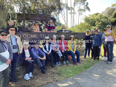
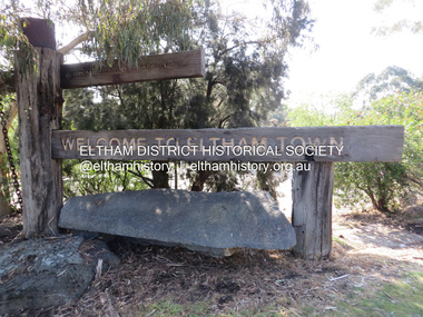
Photograph, Fay Bridge, EDHS Heritage Walk: Shillinglaw Farm, Eltham, 2 September 2023
... Diamond Creek trail behind Andrew Park. The actual farm boundary went past the creek and further up the hill. The original farm comprised lot 90 of Holloway’s 1851 subdivision of Little Eltham. Its area...Diamond Creek trail behind Andrew Park. The actual farm boundary went past the creek and further up the hill. The original farm comprised lot 90 of Holloway’s 1851 subdivision of Little Eltham. Its area ...On Saturday September 2, 2023, Russell Yeoman led a group of 22 society members and interested others on a walk following trhe bounadries of the original Shillingalw farm. Commencing at the corner of Panther Place and Library Place, we proceeded up to Shillinglaw Cafe then the Shillinglaw trees at the former Eltham Shire Office site then along Main Road to the fire station then throughh St Laurence Lane and uinder the railway line , along Diamond Street then return via the Diamond Creek trail behind Andrew Park. The actual farm boundary went past the creek and further up the hill. The original farm comprised lot 90 of Holloway’s 1851 subdivision of Little Eltham. Its area was 30 acres lying east of the Diamond Creek and north of Henry Street. A number of stops were made to look at maps and early photos illustrating the gradual reduction of the farm area and the early history of the railway and other community uses, that occupied parts of the site.fay bridge collection, 2023-09-02, activities, eltham, eltham district historical society, heritage excursion, shillinglaw farm -
 Eltham District Historical Society Inc
Photograph, Liz Pidgeon, EDHS Heritage Walk: Shillinglaw Farm, Eltham, 2 September 2023
... Diamond Creek trail behind Andrew Park. The actual farm boundary went past the creek and further up the hill. The original farm comprised lot 90 of Holloway’s 1851 subdivision of Little Eltham. Its area...Diamond Creek trail behind Andrew Park. The actual farm boundary went past the creek and further up the hill. The original farm comprised lot 90 of Holloway’s 1851 subdivision of Little Eltham. Its area ...On Saturday September 2, 2023, Russell Yeoman led a group of 22 society members and interested others on a walk following trhe bounadries of the original Shillingalw farm. Commencing at the corner of Panther Place and Library Place, we proceeded up to Shillinglaw Cafe then the Shillinglaw trees at the former Eltham Shire Office site then along Main Road to the fire station then throughh St Laurence Lane and uinder the railway line , along Diamond Street then return via the Diamond Creek trail behind Andrew Park. The actual farm boundary went past the creek and further up the hill. The original farm comprised lot 90 of Holloway’s 1851 subdivision of Little Eltham. Its area was 30 acres lying east of the Diamond Creek and north of Henry Street. A number of stops were made to look at maps and early photos illustrating the gradual reduction of the farm area and the early history of the railway and other community uses, that occupied parts of the site.2023-09-02, activities, eltham, eltham district historical society, heritage excursion, shillinglaw farm, 895 main road, amplifon, andrew park, andrew pocket park, arthur street, bar de tapas, barber shop, barry plant estate agent, blockbuster, bus depot, car park, carparks, central park, cleaver & co hair, commonwealth bank, crust pizza, divine bridal, dr ash constance, dudley street, eltham book shop, eltham convenience store, eltham fire station, eltham library, eltham newsagency, eltham optical, eltham railway station, eltham shops, fay bridge, fire bell, flagpole, flight centre, grill'd, information sign, iso chook, jellis craig estate agent, judge book village, kebab nation, kx pilates, la zanyas, liquorland, little drop of poison, lorraine jones & associates solicitors, luck street, machan indian restaurant, main road, mecho en mexico, missing gorilla, morrison kleeman real estate, pavilion menswear, platform 3095, playtherapy melbourne, pryor street, ray white real estate, restaurants, sage bulk whole foods, shillinglaw trees, sign, snap fitness, southern cross medical imaging, specsavers, st laurence lane, st vincents care service, thompson's pharmacy, todaro, united service station, vyve body & skin, welcome to eltham town, westpac bank, yang's kitchen, youth road -
 Eltham District Historical Society Inc
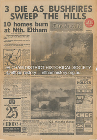
Newspaper - Newspaper articles, The Herald, 3 Die as Bushfires Sweep the Hill: 10 homes burn at Nth. Eltham, The Herald, Wednesday, March 3, p1, 1965
... Hill: 10 homes burn at Nth. Eltham, p1 (Illust.) • 100 dogs die, p1 • Taken on the run, p1 (Illust.) • Fire runs wild at Eltham, p3 (Illust.) • 10-mile front out of control; Gippsland area ablaze, p3 • Trapped, but saved by wind, p3 Tom Fielding Collection Victorian Bushfires - 1965 Victorian Bushfires – 1965 Eltham North Bert Rodda Glen Park Road Short Road Research (Vic.) Wattle Glen Diamond ...Various news articles pertaining to the January 1965 Victorian bushfires specifically with a focus on fires at Eltham North. Specific Eltham Shire districts mentioned include Eltham North and veteran Herald staff photographer Bert Rodda on page 1 • 3 Die as Bushfires Sweep the Hill: 10 homes burn at Nth. Eltham, p1 (Illust.) • 100 dogs die, p1 • Taken on the run, p1 (Illust.) • Fire runs wild at Eltham, p3 (Illust.) • 10-mile front out of control; Gippsland area ablaze, p3 • Trapped, but saved by wind, p3 tom fielding collection, victorian bushfires - 1965, victorian bushfires – 1965, eltham north, bert rodda, glen park road, short road, research (vic.), wattle glen, diamond creek, warrandyte, eltham, gippsland, mrs g. maher, bill dancy, eltham north store, bushfire damage - buildings -
 Eltham District Historical Society Inc
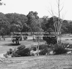
Photograph - Digital Photograph, Alan King, Alistair Knox Park, Eltham, 2008
... area were completed in 1975, with Federal Government funding, and the toilet block in 1978. Bounded by the Eltham railway line, Panther Place, Main Road, Bridge and Susan Streets, the park is in a valley about a kilometre wide overlooked by steep hills at the east and west. The Diamond...area were completed in 1975, with Federal Government funding, and the toilet block in 1978. Bounded by the Eltham railway line, Panther Place, Main Road, Bridge and Susan Streets, the park is in a valley about a kilometre wide overlooked by steep hills at the east and west. The Diamond ...Alistair Knox Park, an oasis of peace and beauty. Covered under National Trust of Australia (Victoria) Landscape Significance and Heritage Overlay, Nillumbik Planning Scheme. Published: Nillumbik Now and Then / Marguerite Marshall 2008; photographs Alan King with Marguerite Marshall.; p173 It is hard to imagine that the Alistair Knox Park, an oasis of peace and beauty beside busy Main Road, Eltham, was once the township’s rubbish dump. It was only in the 1970s that the tip was transformed into this beautiful six hectare space, which later earned it a National Trust Landscape classification. Before its life as a dump, the area was used for small farms. Thanks largely to the foresight and efforts of local environmental builder Alistair Knox, the park was designed sympathetically with the character of the wider Eltham landscape. Then, appropriately, the park was named after Knox, who was an Eltham Shire Councillor from 1971 to 1975 and Shire President in 1975. The park designers were four major forces in the urban bush landscape garden –Knox, landscape designer Gordon Ford, artist Peter Glass and landscaper Ivan Stranger. The National Trust citation for the park, originally called Eltham Town Park, includes the Eltham railway trestle bridge and the Shillinglaw Cottage. The citation states ‘the semi-natural setting of the parkland provides a landscape which is evocative of the history of the area’. Manna Gums (Eucalyptus viminalis) and Candlebarks (Eucalyptus rubida) are significant features. Most of the park’s construction was directed by Bob Grant, Superintendent of the Parks and Gardens Department for the Eltham Shire Council. First plantings occurred in Arbour Week in 1973, then the lake and botanic area were completed in 1975, with Federal Government funding, and the toilet block in 1978. Bounded by the Eltham railway line, Panther Place, Main Road, Bridge and Susan Streets, the park is in a valley about a kilometre wide overlooked by steep hills at the east and west. The Diamond Creek flows through it and the picturesque historic timber trestle railway bridge edges the north. Informal plantings of Australian indigenous and native species in open and undulating grassed settings blend with the natural landscape of the Diamond Creek to the west. The bush-style plants, particularly around the creek, balance with open lawns, paths and a cascade flowing from a small lake to another below. A footbridge over the creek leads to the park’s west. The park includes an adventure playground and barbecue areas. The park stands on part of the land bought from the Crown in 1851 by Josiah Holloway, who subdivided it into allotments and which he called Little Eltham. Most of the land was subdivided into residential lots, but the creek valley, on which the park stands, was subdivided into farm-size lots, used mainly for orchards and grazing. One of the earliest owners was John Hicks Petty, who in 1874 bought a plot from Holloway. Other families who owned properties in that area, included Rees, Clark, Waterfall, Graham, Hill and Morant. In 1901 the railway was built through the area. Jock Read, an Eltham resident since around 1920, remembers several farms in the 1920s and ’30s that occupied the site of today’s park. A poultry farm, which extended from present day Panther Place, was owned by the Gahan family. Next to that farm was another for grazing cattle owned by Jack Carrucan. Beside this was land owned by John Lyon. A doctor lived beside this, and at the north-west corner of Bridge Street and Main Road stood a memorial to the soldiers who died in World War One, which was later moved to the RSL site. Mr Read also remembers other farms and orchards west of the creek In the early 1960s the Eltham Council began buying these farms and in the late 1960s turned the areas east of the Diamond Creek into a garbage tip. When this was filled above the creek’s flood plain, the tip was moved to the west of the creek.This collection of almost 130 photos about places and people within the Shire of Nillumbik, an urban and rural municipality in Melbourne's north, contributes to an understanding of the history of the Shire. Published in 2008 immediately prior to the Black Saturday bushfires of February 7, 2009, it documents sites that were impacted, and in some cases destroyed by the fires. It includes photographs taken especially for the publication, creating a unique time capsule representing the Shire in the early 21st century. It remains the most recent comprehenesive publication devoted to the Shire's history connecting local residents to the past. nillumbik now and then (marshall-king) collection, alistair knox park, eltham -
 Eltham District Historical Society Inc
Document - Folder, Spicer, Whatmough, Chapman, Pill, Moreland families
... area all her life. Her ancestors included Robert Whatmough, Phoebe Chapman, John Pill, and Ada Moreland; she married Charles Spicer. Contents Transcribed and MS notes by Florence Spicer, undated: Spicer/Whatmough/Chapman/Pill/Moreland ancestry. MS notes, undated: Humphrey Spicer. MS notes, undated: Humphrey Spicer with list of children. Newspaper article: "Her 70 years in Cottlesbridge", Diamond Valley News, 4 April 1989. Florence Spicer's family history and current life. Florence Spicer Cottlesbridge Kangaroo Ground Panton Hill ...Florence Spicer was born in Cottlesbridge and lived in the area all her life. Her ancestors included Robert Whatmough, Phoebe Chapman, John Pill, and Ada Moreland; she married Charles Spicer. Contents Transcribed and MS notes by Florence Spicer, undated: Spicer/Whatmough/Chapman/Pill/Moreland ancestry. MS notes, undated: Humphrey Spicer. MS notes, undated: Humphrey Spicer with list of children. Newspaper article: "Her 70 years in Cottlesbridge", Diamond Valley News, 4 April 1989. Florence Spicer's family history and current life. Newspaper clippings, A4 photocopies, etcflorence spicer, cottlesbridge, kangaroo ground, panton hill, st andrews victoria, nillumbik historical society, eltham district historical society, allwood house hurstbridge, john pill, jessie pill nee whatmough, ted pill, florence pill, cottlesbridge post office, charles spicer, st andrews primary school, ladies guild panton hill anglican church, kangaroo ground presbyterian ladies guild, senior citizens hurstbridge, panton hill fire station, robert whatmough, robert cook, emmet whatmough, lamplighter in melbourne, john batman, batman apple tree greensborough, diamond hill estate, phoebe chapman, whatmough park greensborough, jessie whatmough, edwin pill, ada moreland, martha burgess, mary mcmurray, st james church melbourne, george wright of westernport, william spicer, margaret spicer, george spicer, maryanne spicer, sarah spicer, mary spicer, john spicer, alexander humphrey spicer, clara spicer, samson spicer, martha spicer, john henry spicer, arthurs creek cemetery, david clark school master, little eltham school, william mcmurray, sarah mcmurray -
 Eltham District Historical Society Inc
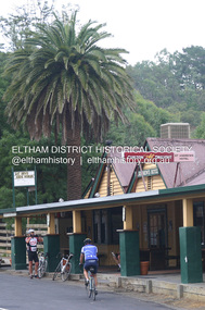
Photograph - Digital Photograph, Alan King, St Andrews Hotel, 2 February 2008
... area, survived the 1960s bushfires, along with a few other early buildings. St Andrews (formerly Queenstown) was founded on gold, as were Panton Hill (formerly Kingstown), Research and Diamond Creek, from the mid-1850s to the 1860s. ...area, survived the 1960s bushfires, along with a few other early buildings. St Andrews (formerly Queenstown) was founded on gold, as were Panton Hill (formerly Kingstown), Research and Diamond Creek, from the mid-1850s to the 1860s. ...The c1860 St Andrews Hotel, with the c1930 additions, and the Canary Island Palm, and the surrounding site to the title boundaries are historically, socially and aesthetically significant to the Shire of Nillumbik. The St Andrews Hotel is historically significant because it may have given its name 'St Andrews' to the town (another suggestion is that the name came from St Andrews church) and for its connection to Ewen Hugh Cameron (1831-1915) the prosperous local farmer, member of the Eltham Roads Board/Shire Council and local MP. It is also significant as the oldest hotel building in the former Shire of Eltham, as one of the few surviving buildings connected with the Caledonian goldfields era and as one of a handful of early structures to have survived the 1960s bushfires; the additions and alterations to the hotel reflect its long life. The hotel is socially significant because it has served as an important meeting place for more than 160 years. The Canary Island Palm is historically significant as a rare example of exotic tree planting in this rural area. The tree is aesthetically and historically significant as a local landmark and for its contribution to the streetscape and landscape value. Covered under Heritage Overlay, Nillumbik Planning Scheme. Published: Nillumbik Now and Then / Marguerite Marshall 2008; photographs Alan King with Marguerite Marshall.; p71 Built around 1860, St Andrews Hotel has changed little since it first welcomed thirsty gold diggers from the Caledonia Goldfields. The timber building, with gabled roof, beamed ceilings and a massive fireplace, is Nillumbik Shire’s oldest hotel and has always been an important community centre, particularly in its early days. Fortunately, the hotel and the near-by Canary Island Palm Tree, which is quite rare in this area, survived the 1960s bushfires, along with a few other early buildings. St Andrews (formerly Queenstown) was founded on gold, as were Panton Hill (formerly Kingstown), Research and Diamond Creek, from the mid-1850s to the 1860s. But by the early 20th century common use changed the name Queenstown to St Andrews, possibly after this hotel or after the church or the mining district.1 The Caledonia Diggings were probably named by Scottish settlers after the Roman name for Scotland, despite this land bearing little similarity to their homeland.2 Queenstown, which was proclaimed as a township in 1861, was the gold-mining centre on the Upper Diamond and in the 1850s had up to 600 European inhabitants and a small camp of Chinese on the flats along the creek. Queenstown was the administrative centre of the Upper Diamond with three hotels, a brewery and a slaughterhouse.3 It is unclear which hotel was the district’s first, as distinct from the earliest unlicensed grog shops, some of which operated in tents. John Corke Knell was one of eight unlicensed storekeepers supplying drink to miners at Caledonia in 1857, named by Sgt. McNamara of the Caledonia Police Station.4 In February 1859, Knell apparently bought most of the present hotel’s site at the first township land sales. As he was a local storekeeper, he might have first established a store there.5 Knell and his wife Eliza were early licensees of the St Andrews Hotel. The hotel had eight bedrooms – including three for public use – and the dining-room seated 30 people. It is thought they named the hotel St Andrews after Eliza’s hometown of St Andrews in Scotland. St Andrews Hotel was an important local centre in several ways. In the same building the Knells also operated a post office and general store. In 1867 Mrs Knell was appointed Deputy Registrar of Births and Deaths for Queenstown. The hotel was also used to hold inquests into people’s deaths when the police residence became too small.6 The hotel also became a fashionable destination at Christmas for parties from Melbourne. In 1868, possibly following her husband’s death, Mrs Knell applied for a temporary licence, which was then transferred to Robert Smith after their marriage in 1869. But then, possibly after Robert’s death, Mrs Smith operated the hotel until 1892. This contradicts a report in The Evelyn Observer 1882 that JC Knells of the St Andrews Hotel was granted a publican’s licence in the Queenstown Police Court. At that time he was supposed to have been dead for around 14 years! Although Mrs Smith was a respected citizen, known for her geniality and as an ideal hostess, she had a minor brush with the law when she was fined ten shillings for not lighting a lamp outside her licensed premises.7 From 1892 several publicans owned the hotel including W Atkins, from 1895. In 1909 the licensee was apparently Mrs Smith’s son, Walter Knell, who held the licence until at least the 1920s. Not surprisingly, this old hotel has attracted romantic stories. Mrs Smith is said to be seen roaming the pub in her nightdress – even though she was buried in the Queenstown Cemetery in 1911.8 A musical The Hero of Queenstown, set in the hotel, was written and produced by local actor Reg Evans in the 1970s.This collection of almost 130 photos about places and people within the Shire of Nillumbik, an urban and rural municipality in Melbourne's north, contributes to an understanding of the history of the Shire. Published in 2008 immediately prior to the Black Saturday bushfires of February 7, 2009, it documents sites that were impacted, and in some cases destroyed by the fires. It includes photographs taken especially for the publication, creating a unique time capsule representing the Shire in the early 21st century. It remains the most recent comprehenesive publication devoted to the Shire's history connecting local residents to the past. nillumbik now and then (marshall-king) collection, st andrews hotel -
 Eltham District Historical Society Inc
Photograph - Digital Photograph, Alan King, Site of the Diamond Creek Gold Mine, 28 December 2007
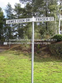
... area originated from a find in 1862. The mine was closed January 20, 1915 when a fire destroyed nearly all the above ground plant. Published: Nillumbik Now and Then / Marguerite Marshall 2008; photographs Alan King with Marguerite Marshall.; p75 Beneath Mine Hill, as locals call it, runs a network of tunnels once of central importance to the fledgling township of Diamond Creek. ...area originated from a find in 1862. The mine was closed January 20, 1915 when a fire destroyed nearly all the above ground plant. Published: Nillumbik Now and Then / Marguerite Marshall 2008; photographs Alan King with Marguerite Marshall.; p75 Beneath Mine Hill, as locals call it, runs a network of tunnels once of central importance to the fledgling township of Diamond Creek. ...The largest gold mine in the area originated from a find in 1862. The mine was closed January 20, 1915 when a fire destroyed nearly all the above ground plant. Published: Nillumbik Now and Then / Marguerite Marshall 2008; photographs Alan King with Marguerite Marshall.; p75 Beneath Mine Hill, as locals call it, runs a network of tunnels once of central importance to the fledgling township of Diamond Creek. These are relics of gold mines, which transformed early Diamond Creek.1 The tiny settlement of about 20 families soared to more than 200 because of gold. For around 50 years, from 1862, gold mining was Diamond Creek’s major source of employment. On September 7, 1854 The Argus newspaper reported a find of a four pound (1.8kg) gold nugget in Nillumbik (an early name for Diamond Creek). Exactly where, is not known.2 The largest mine in the district, the Diamond Creek Gold Mine, apparently originated from a find in 1862. It is said Joe and Dave Wilson were visiting former tailor then cook, Charles Orme, at the southern end of Fraser Street. Sitting on a stump outside the front gate on land belonging to Dr A. E. Phipps the Wilsons found a vein of gold-bearing quartz, which led to the discovery of four quartz reefs varying in width to eight inches (20cm), running north and south. A reef found at the foot of the hill opposite Challenger Street became the Union Mine. This reef was traced south to Allendale Road where a small mine began operations.3 Other smaller mines later operated as well. Dr Phipps immediately began to mine and also built the Diamond Reef Hotel as a boarding house for miners. But Charles Orme, who owned the land alongside, leased his mine to Dr Phipps probably because of insufficient funds and business skills. By mid 1865 the mine had produced 2530 ounces of gold – a 100% profit on the original outlay. Of course there were problems. When the local dam dried up a Blake pump was installed to draw water from the creek. The Union Mine operated under the Diamond Creek Gold Mine management except when disputes sometimes resulted in separate management. However disagreements had to be resolved as the Union Mine depended on Diamond Creek Gold Mine pumps to remove underground water from common reefs. In 1912 the main shaft of about 380 yards (350m) employed 200 men recovering an average of 5000 ounces (141.7kg) of gold a year. But not everyone did well out of gold. Records of failed mining companies in the Victorian Public Record Office, reveal that owner Dr Phipps leased his Right to others. Companies came and went over the next 40 years, most sponsored by Melbourne businessmen who sold shares to gullible locals and then became insolvent. Although there were some good profits, financial returns were haphazard until 1905. Some local residents, who were share holders in short- term companies, became well-known names in modern Diamond Creek such as Scott, Haley, Butler, Alder, Ryan, Wadeson, Reeves, Alston, Paul and Edwards. Gold mining was brought to a disastrous end on January 20, 1915 at 3 pm, when fire destroyed nearly all the above-ground plant. Fortunately no lives were lost. But reopening the mine was almost impossible because of the increasing depth of water in the main shaft. The closed mine destroyed the livelihood of 200 families and the debris took many years to clear.4 In 1946 the Diamond Creek Gold Mine was reopened by the Golden Hind Mining Company, but money ran out before the 600 feet (182.8m) or so of water could be removed. Gold remains in the mine but enormous capital would be needed to buy the land, equipment and to remove the water. Today 12 known sealed shafts along the ridge of the hills on private property extend west for around one kilometre from the corner of Fraser and Haley Streets, crossing Norma and Fyffe to Dering Streets. As recently as 1987, heavy rains revealed a former Union Mine shaft in the Georgiadis family Fyffe Street back yard.5 Allendale Mine, south of Allendale Road, is still open and one of the Union Mine’s main drives (horizontal excavation) remains unsealed, on the Creek Reserve.This collection of almost 130 photos about places and people within the Shire of Nillumbik, an urban and rural municipality in Melbourne's north, contributes to an understanding of the history of the Shire. Published in 2008 immediately prior to the Black Saturday bushfires of February 7, 2009, it documents sites that were impacted, and in some cases destroyed by the fires. It includes photographs taken especially for the publication, creating a unique time capsule representing the Shire in the early 21st century. It remains the most recent comprehenesive publication devoted to the Shire's history connecting local residents to the past. nillumbik now and then (marshall-king) collection, diamond creek, diamond creek mine, fraser street, gold mining, james cook drive, mine hill -
 Bendigo Historical Society Inc.
Document - MCCOLL, RANKIN AND STANISTREET COLLECTION: ANGOVE AND CARRS LEASE, DIAMOND HILL, 1935
... McColl Rankin & Stanistreet, Angove & Carrs Lease, Diamond Hill. a/ Manila folio Markings: Angove & Carrs Lease Diamond Hill. Freed?aus Extended. b/ Plan Area Applied For On Lease No. 10103 Ben. ...History House 11 Mackenzie Street Bendigo goldfields ORGANIZATION Business gold mine McColl Rankin & Stanistreet Angove & Carrs Lease Diamond Hill A A Macintosh Parish of Mandurang County of Bendigo W J Angove August 12th 1933 Summerhill Anticlines 6 Month Report 27/2/1935 Golden Fleece mine near Spring Gully Reservoir McColl Rankin & Stanistreet, Angove & Carrs Lease, Diamond Hill. a/ Manila folio Markings: Angove & Carrs Lease Diamond Hill. Freed?aus Extended. b/ Plan Area ...McColl Rankin & Stanistreet, Angove & Carrs Lease, Diamond Hill. a/ Manila folio Markings: Angove & Carrs Lease Diamond Hill. Freed?aus Extended. b/ Plan Area Applied For On Lease No. 10103 Ben. By A A Macintosh. Mining District of Bendigo Parish of Mandurang County of Bendigo. Inscriptions: G Birch advises 16/5/35. Survey made by Assistant he has yet to receive. 10710 W J Angove - Spring Gully PO. Dated August 12th 1933 signed: Garnet G Birch J Victor Buley. c/ Agreement of lease for 1 month with the option of 9 months, followed by the option of purchase between Summerhill Anticlines NL of Adelaide and Angove & Carr at German Gully (Mandurang). Markings: 25/3/13 note by Summerhill Anticline NL. Requests information as to whether or not the Syndicate (E Mann, W Angove & H Irvine, H. Mc……….) desire to take up the options of lease or not. d/ Notice to Shareholders of a meeting in Collins Street Melbourne. 6 March, 1935 to consider proposals of the future of the company. J G Stanfield & Stewart, Manager. e/ Neangar Gold Mining Company NL 6 Month Report 27/2/1935 Business, Director's Report & Financial Report. f/ Report by A J J Moore BCE Mining Engineer, Ramrod Lease, Golden Fleece Mine near Spring Gully Reservoir the most Southern mine being Worked in Bendigo. Lease in on the Carshalton line. Report details the progress of the workings at the mine.organization, business, gold mine, mccoll rankin & stanistreet, angove & carrs lease, diamond hill a a macintosh parish of mandurang county of bendigo w j angove august 12th 1933 summerhill anticlines 6 month report 27/2/1935 golden fleece mine near spring gully reservoir -
 Greensborough Historical Society
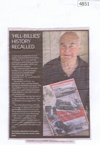
Newspaper Clipping, Diamond Valley Leader, 'Hill-Billies' History Recalled, 25/10/2017
... hill-billies" sat on their porches surveying an area known as Grace Park with only cattle, rabbits and kangaroos for company. The book is available from the Greensborough Historical Society. grace park greensborough historical society do you recall News article 1 page, black text and colour image. 'Hill-Billies' History Recalled Newspaper Clipping Diamond ...A new book "Do You Recall?" reveals the unusual history of parts of Watsonia where "hill-billies" sat on their porches surveying an area known as Grace Park with only cattle, rabbits and kangaroos for company. The book is available from the Greensborough Historical Society. News article 1 page, black text and colour image.grace park, greensborough historical society, do you recall -
 Greensborough Historical Society
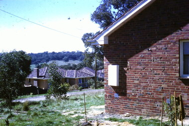
Photograph - Digital Image, View from Flodden Way Briar Hill, 1966-1969
... Diamond Creek and having ash inside our home." The Noone family lived at 1 Flodden Way from 1966 to 1969. Caption by Julie Noone 2017. Shows the development of the area in the 1960s. flodden way briar hill Digital copy of colour photograph, taken from photographic slide. ...View from Flodden Way, looking across to the next ridge. "I remember a row of houses being burnt beyond that ridge at Diamond Creek and having ash inside our home." The Noone family lived at 1 Flodden Way from 1966 to 1969. Caption by Julie Noone 2017.Shows the development of the area in the 1960s.Digital copy of colour photograph, taken from photographic slide.flodden way briar hill -
![Photograph - Digital image, House St Helena and Diamond Creek Roads [Greensborough], 02/05/2013](/media/collectors/4f729f5697f83e03086015b8/items/5729bbd22162f108e8de5be2/item-media/5729bc112162f108e8de617d/item-fit-380x285.jpg?cb=6) Greensborough Historical Society
Greensborough Historical SocietyPhotograph - Digital image, House St Helena and Diamond Creek Roads [Greensborough], 02/05/2013
... These photographs of the house on the corner of St Helena and Diamond Creek Roads was taken in 2013 to show changes over 40 years, based on Ron Reynold's sketches in the 1973 publication 'Greensborough and Greenhills' published by Cypress Books... which states "Built on a steep hill in a bush setting in the early 1920s, for a Dr Wood, the weatherboard house now overlooks an area of activity and change. ...Greensborough Historical Society 34A Glenauburn Road Lower Plenty Lower Plenty melbourne These photographs of the house on the corner of St Helena and Diamond Creek Roads was taken in 2013 to show changes over 40 years, based on Ron Reynold's sketches in the 1973 publication 'Greensborough and Greenhills' published by Cypress Books... which states "Built on a steep hill in a bush setting in the early 1920s, for a Dr Wood, the weatherboard house now overlooks an area of activity and change. ...These photographs of the house on the corner of St Helena and Diamond Creek Roads was taken in 2013 to show changes over 40 years, based on Ron Reynold's sketches in the 1973 publication 'Greensborough and Greenhills' published by Cypress Books... which states "Built on a steep hill in a bush setting in the early 1920s, for a Dr Wood, the weatherboard house now overlooks an area of activity and change. The owners, Mr and Mrs E. 'Bluey' Blackburn, remember when their 3/4 acre building block dropped to the edge of a dirt road. Today the view from the high verandah encompasses the Main Street shopping centre, new and old bridges, new roads and houses, the Plenty River, natural bush, hills and sports grounds."Digital copy of colour photograph.greensborough and greenhills, st helena road greensborough, diamond creek road greensborough, wood family, ron reynolds