Showing 104 items matching "distance measures"
-
 Kiewa Valley Historical Society
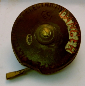
Tape Measure 33ft, Early to mid 1900's
... measure...distance measures...It provides evidence that small measuring equipment used in the construction and the continuing maintenance of the scheme was of the imperial measure and used by construction workers who remained and settled in the town of Mount Beauty and Kiewa Valley long after the construction period. imperial tape measure distance measures imperial tools Embossed in the leather casing"MADE IN ENGLAND" and around the inner circle "HOCKLEY ABBEY" and "JOHN RABONE & SONS" This flexible metallic measuring tape (33 ft in length) is contained in a round circular leather bound container. ...This flexible measuring tape was used by the SEC Victoria in the mid to late 1900's. It was in a period before digital measuring instruments were in use. This is a 33ft long tape measure and would have been used by the construction workers when building the Kiewa Valley Hydro System. The warning details (embossed into the leather covering) was to warn users to be careful not to use the tape near live electricity terminals or linkages. This tape was produced mainly for wooden structures and not electricity conductive material. This was during the 1950's to 1960's.This imperial tape measure is very significant to the Kiewa Valley as it was used in the construction of the Kiewa Valley Hydro Scheme of the 1950's-1960's. It provides evidence that small measuring equipment used in the construction and the continuing maintenance of the scheme was of the imperial measure and used by construction workers who remained and settled in the town of Mount Beauty and Kiewa Valley long after the construction period. This flexible metallic measuring tape (33 ft in length) is contained in a round circular leather bound container. It has brass fittings (winder and tape guide) and is stitched with heavy grade twine. The tape measure is graduated in feet and inches on one side and yards on the other. Embossed in the leather casing"MADE IN ENGLAND" and around the inner circle "HOCKLEY ABBEY" and "JOHN RABONE & SONS"imperial tape measure, distance measures, imperial tools -
 Department of Energy, Environment and Climate Action
HipChain Distance Measurer
... HipChain Distance Measurer...Forest measurement Surveying HipChain Distance Measurer HipChain Distance Measurer ...Hipchains are a reliable tool for precise long distance measurement, particularly with irregular boundaries, in rough terrain or thick scrub To use, simply tie the cotton thread to a fixed object at your starting point, zero the counter, and start walking. As you move, the thread extends, turning the counter. The instrument attaches to your belt, keeping the thread taut and accurate. Once you reach your endpoint, break the thread and continue.HipChain Distance Measurerforest measurement, surveying -
 Federation University Historical Collection
Photograph, Ballarat School of Mines E.J. Tippett Library
... The images were taken during the second year of the Covid19 pandemic when social distancing measures, quarantining, and sectional closures were in place. ...The images were taken during the second year of the Covid19 pandemic when social distancing measures, quarantining, and sectional closures were in place. ...The E.J. Tippett Library is a Federation University Australia campus library and is located on the SMB campus. The images were taken during the second year of the Covid19 pandemic when social distancing measures, quarantining, and sectional closures were in place. Interior images of the Ballarat School of Mines E.J. Tippett Library, counter, book return shoot.e.j. tippett library, smb library, library, book return shoot, pandemic, covid19 -
 Bendigo Military Museum
Equipment - MAP MEASURER/OPISMETER, DEPOSE
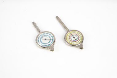
... Vintage opisometer used for measuring distances on maps. Part of the Kevin John Herdman, No. 397661, Collection. ...As it turns, the hand on the front dial turns to measure distance. .2) Rigid plastic rectangular storage case in two parts. ...As it turns, the hand on the front dial turns to measure distance. .2) Rigid plastic rectangular storage case in two parts. ...Vintage opisometer used for measuring distances on maps. Part of the Kevin John Herdman, No. 397661, Collection. See Catalogue No. 5942P for details of his service record..1) Circular chromed metal instrument with handle. Calibrated dial with black markings and hand on a white background. Reverse face has unit conversion details in black text on white background. Each face is covered with a convex glass lens. On the opposite end to the handle is a small wheel with milled edge. As it turns, the hand on the front dial turns to measure distance. .2) Rigid plastic rectangular storage case in two parts. Base is yellow, top is clear..1) Printed on front dial: 'INCHES, MADE IN FRANCE'. Printed on back dial: 'Unit conversion details'. Stamped on metal near wheel: 'DEPOSE, H(logo)B'. .2) Stamped on clear cover: 'CURVIMETRE, MAP MEASURER, H(logo)B, MADE IN FRANCE'.map, map measure, equipment, opisometer, kevin john herdman -
 Department of Energy, Environment and Climate Action
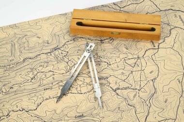
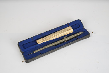
Mapping dividers
... used to measure distances on maps...Department of Energy, Environment and Climate Action 71-79 Kyle Road Altona North used to measure distances on maps Forests Commission Victoria (FCV) Forest measurement Surveying mapping Adjustable stainless steel mapping dividers with wooden box Mapping dividers ...used to measure distances on mapsAdjustable stainless steel mapping dividers with wooden boxforests commission victoria (fcv), forest measurement, surveying, mapping -
 Department of Energy, Environment and Climate Action
Mapping Dividers
... used to measure distances on maps...Department of Energy, Environment and Climate Action 71-79 Kyle Road Altona North used to measure distances on maps Forests Commission Victoria (FCV) Forest measurement Surveying mapping Adjustable stainless steel mapping dividers with wooden box Mapping Dividers ...used to measure distances on mapsAdjustable stainless steel mapping dividers with wooden boxforests commission victoria (fcv), forest measurement, surveying, mapping -
 Department of Energy, Environment and Climate Action
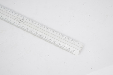
Mapping scale ruler
... Used to measure distance on scale maps...Department of Energy, Environment and Climate Action 71-79 Kyle Road Altona North Used to measure distance on scale maps Forests Commission Victoria (FCV) Surveying mapping W&G Scale ruler Mapping scale ruler ...Used to measure distance on scale mapsScale rulerW&G forests commission victoria (fcv), surveying, mapping -
 Musculoskeletal Health Australia (now held by the Glen Eira Historical Society)
Photograph - Group photo
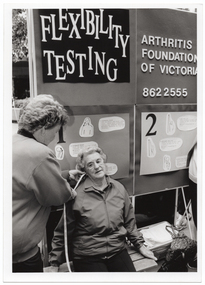
... Using a measuring tape, she measures the distance between a woman's ear and shoulder....B&W photo of a woman using a measuring tape to measure the distance between another woman's ear and shoulder. ...Using a measuring tape, she measures the distance between a woman's ear and shoulder. arthritis foundation of victoria afv rheumatism and arthritis association of victoria raav joint action team jag flexibility testing joint health muscle health muscle tension mobility movement assessment measurement B&W photo of a woman using a measuring tape to measure the distance between another woman's ear and shoulder. ...At an unidentified event, a member of the Joint Action Team staffs a Flexibility Testing stand. Using a measuring tape, she measures the distance between a woman's ear and shoulder.B&W photo of a woman using a measuring tape to measure the distance between another woman's ear and shoulder. Behind them is a display board with the words "Flexibility testing", "Arthritis Foundation of Victoria", the telephone number "862 2555", and various sketch drawings with corresponding text.arthritis foundation of victoria, afv, rheumatism and arthritis association of victoria, raav, joint action team, jag, flexibility testing, joint health, muscle health, muscle tension, mobility, movement, assessment, measurement -
 Port Melbourne Historical & Preservation Society
Book - Maritime handbook, F G Strang, F G Strang Pty Ltd, 1940s
... Complimentary book by F.G.Strang setting out stowage weights, sea distances, weight and measure tables....Port Melbourne Historical & Preservation Society Port Melbourne Town Hall 333 Bay Street Port Melbourne melbourne maritime melbourne harbor trust - port of melbourne authority f g strang Complimentary book by F.G.Strang setting out stowage weights, sea distances, weight and measure tables. Book Maritime handbook, F G Strang F G Strang Pty Ltd ...Complimentary book by F.G.Strang setting out stowage weights, sea distances, weight and measure tables.maritime, melbourne harbor trust - port of melbourne authority, f g strang -
 Queenscliffe Maritime Museum
Instrument - Trailing Ship's Log
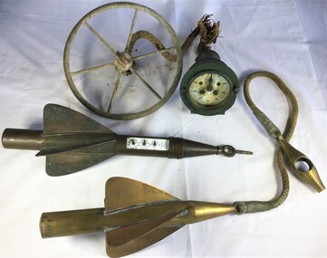
... Metal trailing log comprising of a gauge and two rotors towed behind ships to measure distance....Metal trailing log comprising of a gauge and two rotors towed behind ships to measure distance. Instrument Trailing Ship's Log T.Walker ...Used to 1935 by John Gordon Hanby while in the militia at Fort Queenscliffe.Metal trailing log comprising of a gauge and two rotors towed behind ships to measure distance.Walker's, Cherve, Mark III.towing log, measuring distance, ship's log -
 City of Greater Bendigo - Civic Collection
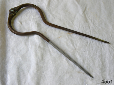
Instrument - Gunter Chain, not known
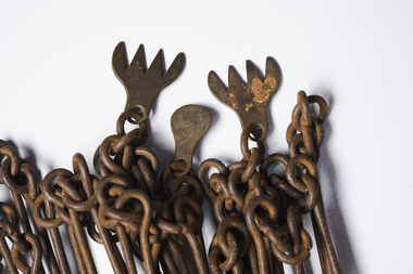
... Gunter's chain (also known as Gunter’s measurement) is a distance measuring device used for surveying. It was designed and introduced in 1620 by English clergyman and mathematician Edmund Gunter (1581–1626). ...City of Greater Bendigo - Civic Collection Bendigo Town Hall 189-193 Hargreaves St, Bendigo, 3550 goldfields Gunter's chain (also known as Gunter’s measurement) is a distance measuring device used for surveying. It was designed and introduced in 1620 by English clergyman and mathematician Edmund Gunter (1581–1626). ...Gunter's chain (also known as Gunter’s measurement) is a distance measuring device used for surveying. It was designed and introduced in 1620 by English clergyman and mathematician Edmund Gunter (1581–1626). It enabled plots of land to be accurately surveyed and plotted, for legal and commercial purposes. The provenance of this particular Gunter Chain is unknown but it is believed to be used either by the City of Bendigo / Sandhurst or the Lands Department locally when measuring and laying out plots and streets locally. A 66-foot (20.1 m) chain divided into 100 links, marked off into groups of 10 by brass rings or tags. Each link is 7.92 inches (201 mm) long. A quarter chain, or 25 links, measures 16 feet 6 inches (5.03 m) also called a a rod (or pole) measure. Ten chains measure a furlong and 80 chains measure a statute mile. city of greater bendigo surveying -
 Department of Energy, Environment and Climate Action
map measuring wheels
... The map wheel is a simple, fast and accurate way to measure distances on maps, whether in straight lines or along curves. ...Department of Energy, Environment and Climate Action 71-79 Kyle Road Altona North The map wheel is a simple, fast and accurate way to measure distances on maps, whether in straight lines or along curves. ...The map wheel is a simple, fast and accurate way to measure distances on maps, whether in straight lines or along curves. Hold the device from the tip and trace with the small wheel at the bottom along the line to be measured Measures distances in miles, kilometres or nautical miles depending on the scale on the side.Two metal map measuring wheel sMap scales on each side of wheelforests commission victoria (fcv), surveying, mapping -
 Greensborough Historical Society
Ruler, Scale rule for map reading, 1950c
... Small rule to measure distance when reading a scale map. Measurements in yards or meters....Greensborough Historical Society 34A Glenauburn Road Lower Plenty Lower Plenty melbourne Small rule to measure distance when reading a scale map. Measurements in yards or meters. map reading scale ruler Small plastic rule, cream colour with black markings. ...Small rule to measure distance when reading a scale map. Measurements in yards or meters.Small plastic rule, cream colour with black markings.map reading, scale ruler -
 Bendigo Military Museum
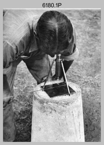
Photograph - RASvy Surveyors in the field, c1950s – 1960s
... This is a set of 1photographs of surveyors in the field measuring distances using chains, taking observations using theodolites and operating electric distance measurement equipment. ...This is a set of 17 photographs of surveyors in the field measuring distances using chains, taking observations using theodolites and operating electric distance measurement (EDM) equipment. c1950s – 1960s. ...The tellurometer in Photos .14P to .16P was a MRA1 microwave Electronic Distance Measuring instrument (EDM) introduced in 1958. ...This is a set of 1photographs of surveyors in the field measuring distances using chains, taking observations using theodolites and operating electric distance measurement equipment. They were probably employed in establishing mapping and geodetic control operations or the surveyors may have been in training. The photos were most likely taken in the 1950s and 1960s. Photos .1P to .6P feature personnel setting up geodetic survey chaining equipment to measure distances. The surveyor in Photo .5P is LTCOL Howard Angus Johnson MBE who served from 1936 to 1954. The RA Svy surveyor in photos .7P to .12P were using a theodolite to take angular measurements. They were usually supported by an observer who recording their readings on a booking form. The surveyor in Photo .10P and .11P is LTCOL Jorge Gruszka, who served from 1955 to 1985. He was CO of the Army Survey Regiment from 1982 to 1985. The surveyor in photo .13P is cutting an identification blaze on a tree using a hammer and chisel. The tellurometer in Photos .14P to .16P was a MRA1 microwave Electronic Distance Measuring instrument (EDM) introduced in 1958. It and later models were man-portable systems that improved geodetic survey efficiencies for rapid network extension and densification replacing triangulation with EDM and theodolite traverse sometimes using Bilby Towers to extend line lengths. The surveyor with the slouch hat is Colonel James ‘Jim’ Leslie Stedman, who served from 1941 to 1978. He was Director of Military Survey from 1975 to 1978 and was appointed as Colonel Commandant (honorary appointment, Retd) of the Royal Australian Survey Corps from 1978 to 1983. Jim Stedman is demonstrating EDM equipment.This is a set of 17 photographs of surveyors in the field measuring distances using chains, taking observations using theodolites and operating electric distance measurement (EDM) equipment. c1950s – 1960s. The photographs were printed on photographic paper and are part of the Army Survey Regiment’s Collection. The photographs were scanned at 300 dpi. .1) - Photo, black & white, c1950s, unidentified personnel using geodetic survey chaining equipment. .2) to .4) - Photo, black & white, c1950s, geodetic survey chaining equipment. .5) – Photo, black & white, c1950s, Jim Stedman using geodetic survey chaining equipment to measure distances. .6) - Photo, black & white, c1950s, Unidentified personnel geodetic survey chaining equipment. .7) – Photo, black & white, mounted on card, c1950s. Unidentified surveyor undertaking observations on a coral reef using a theodolite. .8) – Photo, black & white, c1950, unidentified surveyor undertaking observations with a Tavistock theodolite. .9) – Photo, black & white, mounted on green card, c1950s. Unidentified surveyor undertaking observations using a plane table. .10) – Photo, black & white, c1955, Jorge Gruszka undertaking observations with a theodolite. 7/55 Basic Survey Course Balcombe. .11) – Photo, black & white, c1950s, Jorge Gruszka undertaking observations with a theodolite. .12) – Photo, black & white, c1946-1948, unidentified surveyor undertaking observations with a theodolite to gain control for the mapping of the Snowy Mountain Diversion Scheme. .13) – Photo, black & white, c1950s, unidentified surveyor cutting a blaze in a tree. .14) and .15) – Photo, black & white, c1960s, Jim Stedman demonstrating EDM equipment. .16) – Photo, black & white, c1960s, L to R: Jim Stedman (probably) and unidentified surveyor demonstrating EDM equipment. .17) – Photo, black & white, 1956, Operation Cutlass - Surveyors SPR W. Crane and J.A. Campbell undertaking observations with a theodolite in extreme conditions..1P on back - First Order Chaining Equipment .2P on back - First Order Chaining Equipment .3P on back - Full catenary 1800 – 1960 replaced by EDM .4P on back - First Order Chaining Equipment .5P on back - H.A. Johnson, Benambra baseline? 1st Order Chaining .6P on back - Chaining .7P on front - Difficult observing conditions especially when the tide is in. The station is sighted (sic) on a coral reef. .8P on back - Tavistock. .10P on back of duplicate in Photo Folder 14 – George (sic) Gruszka 7/55 Basic Survey Course Balcomme (sic) 1955/56 .14P and .15P on back - Jim Stedman demonstrating early EDM equipment.royal australian survey corps, rasvy, army survey regiment, army svy regt, fortuna, asr, surveying -
 Greensborough Historical Society
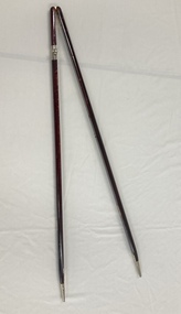
Article, Anne Paul, Robert Hoddle - Chains and Grids in Terra Nullius, January 2024
... Article about Robert Hoddle, his work as a surveyor in early Melbourne and the use of the 'chain' to measure distance....Greensborough Historical Society 34A Glenauburn Road Lower Plenty Lower Plenty melbourne Article about Robert Hoddle, his work as a surveyor in early Melbourne and the use of the 'chain' to measure distance. Melbourne History Robert Hoddle 14 page article text and illus. ...Article about Robert Hoddle, his work as a surveyor in early Melbourne and the use of the 'chain' to measure distance.14 page article text and illus.melbourne history, robert hoddle -
Creswick Campus Historical Collection - University of Melbourne
Equipment, Curvimeter
... Steel tool with moving wheel attached to measurement dial. For measuring distance of irregular line on maps. Cased in blue box with clear lid...Creswick Campus Historical Collection - University of Melbourne 4 Water Street University of Melbourne Creswick Campus Building 719/718 Creswick goldfields Steel tool with moving wheel attached to measurement dial. For measuring distance of irregular line on maps. Cased in blue box with clear lid Equipment Curvimeter Equipment ...Steel tool with moving wheel attached to measurement dial. For measuring distance of irregular line on maps. Cased in blue box with clear lidEquipment -
 Melbourne Legacy
Ceremonial object, Military Pace Stick
... A pace stick is a training instrument used to gauge the length of pace and measure distance and interval for military parades. ...A pace stick is a training instrument used to gauge the length of pace and measure distance and interval for military parades. ...A hinged wooden stick that is used in military situations. It is kept in the Comradeship Lounge as a link to the legatees' military background. A pace stick is a training instrument used to gauge the length of pace and measure distance and interval for military parades. Legacy has a strong link to the military, most early legatees would be familiar with the pace stick and its use.Wooden stick that is hinged, has metal tips and is used as a pace tool.comradeship, pace stick -
 Bendigo Military Museum
Uniform - PACE STICK, ARMY, Australian Defence Industries, Unknown
... Pace stick - a training instrument used to gauge the length of pace and measure distance and interval for military parades and military situations. ...Bendigo Military Museum 37 - 39 Pall Mall Bendigo goldfields Pace stick - a training instrument used to gauge the length of pace and measure distance and interval for military parades and military situations. ...Pace stick - a training instrument used to gauge the length of pace and measure distance and interval for military parades and military situations. Pace stick issued to G. WESTHEAD, No. 317595/8233929. Refer Cat No. 1496.7 for Service Records.Pace stick, two pieces of timber with brown stain and gloss varnish, brass metal hinge at the top. Two silver colour metal tips at bottom. Silver colour metal fittings along length of timber sticks are used to set a particular distance.uniform, army, pace stick, military police, g. westhead -
 Department of Energy, Environment and Climate Action
FCV measuring band
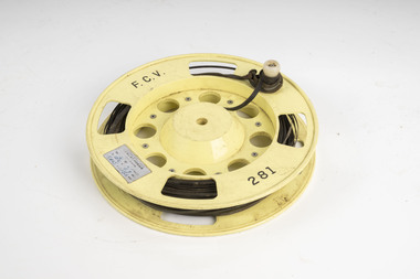
... Used for measuring distances in the forest. Steel bands (out of tradition were called the chain) were created around 1890. ...Department of Energy, Environment and Climate Action 71-79 Kyle Road Altona North Used for measuring distances in the forest. Steel bands (out of tradition were called the chain) were created around 1890. ...Used for measuring distances in the forest. Steel bands (out of tradition were called the chain) were created around 1890. They replaced the traditional Gunter chain. The band could be repaired by soldering slip-on joiners and than and recalibrating.Steel measuring band (50m) on plastic reel with winding handleFCV 281forests commission victoria (fcv), assessment, forest measurement, surveying, mapping -
 Department of Energy, Environment and Climate Action
FCV measuring band
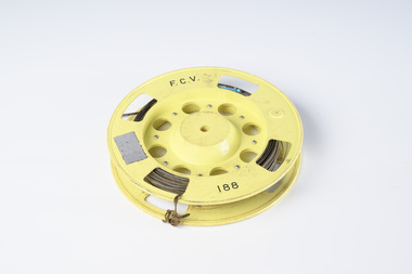
... Used for measuring distances in the forest. Steel bands (out of tradition were called the chain) were created around 1890. ...Department of Energy, Environment and Climate Action 71-79 Kyle Road Altona North Used for measuring distances in the forest. Steel bands (out of tradition were called the chain) were created around 1890. ...Used for measuring distances in the forest. Steel bands (out of tradition were called the chain) were created around 1890. They replaced the traditional Gunter chain. The band could be repaired by soldering slip-on joiners and than and recalibrating.Steel measuring band (50m) on plastic reel with winding handle missingFCV 188forests commission victoria (fcv), assessment, forest measurement, surveying, mapping -
 Department of Energy, Environment and Climate Action
FCV measuring band
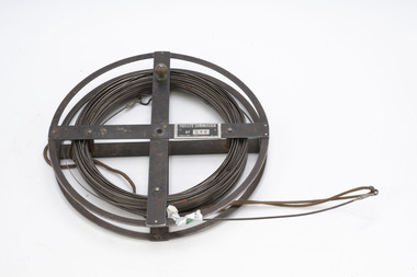
... Used for measuring distances in the forest. Steel bands (out of tradition were called the chain) were created around 1890. ...Department of Energy, Environment and Climate Action 71-79 Kyle Road Altona North Used for measuring distances in the forest. Steel bands (out of tradition were called the chain) were created around 1890. ...Used for measuring distances in the forest. Steel bands (out of tradition were called the chain) were created around 1890. They replaced the traditional Gunter chain. The band could be repaired by soldering slip-on joiners and than and recalibrating.Steel measuring band (1 chain - 66 feet) on metal reelFCV 075forests commission victoria (fcv), assessment, forest measurement, surveying, mapping -
 Flagstaff Hill Maritime Museum and Village
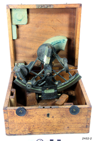
Instrument - Sextant, Troughton & Simms, late 19th C. to 1922
... A sextant is an astronomical instrument used in measuring angular distances especially the altitudes of sun, moon and starts at sea determining latitude and longitude....A sextant is an astronomical instrument used in measuring angular distances especially the altitudes of sun, moon and starts at sea determining latitude and longitude. ...This sextant is very similar to a 1915 Sextant design. A sextant is an astronomical instrument used in measuring angular distances especially the altitudes of sun, moon and starts at sea determining latitude and longitude.This sextant is an example of a 19th-century marine instrument used for finding location at sea. It was made by London scientific instrument maker Troughton and Simms, which originated in 1826 and continued until 1922.Sextant and its fitted square wooden box. The handle of the sextant is carved with a cross-hatched pattern. Made by Troughton and Simms, London.flagstaff hill, warrnambool, shipwrecked-coast, flagstaff-hill, flagstaff-hill-maritime-museum, maritime-museum, shipwreck-coast, flagstaff-hill-maritime-village, sextant, navigational instrument, marine navigation, marine equipment, instrument, navigation, troughton and simms, london, scientific instrument -
Frankston RSL Sub Branch
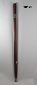
Rule, Scale, E. ESDAILE & SONS, 1942
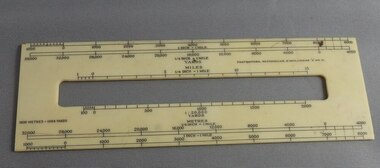
... A scale rule used by artillery units to measure distance between map co-ordinates on the 1 to 25,000 scale military map series. ...Frankston RSL Sub Branch 183 Cranbourne Road Frankston mornington-peninsula artillery rule scale imperial metric distance world war 2 ww2 The rule is stamped with the following: "SCALE, ARTY, No 2, MKI, E.ESDAILE & SONS, D^D, 1942" A scale rule used by artillery units to measure distance between map co-ordinates on the 1 to 25,000 scale military map series. ...A scale rule used by artillery units to measure distance between map co-ordinates on the 1 to 25,000 scale military map series. The rule is accurately machined from flat stainless steel strip and is stamped with Imperial measurements (thousands of yards) and metric measurements (thousands of metres).The rule is stamped with the following: "SCALE, ARTY, No 2, MKI, E.ESDAILE & SONS, D^D, 1942"artillery, rule, scale, imperial, metric, distance, world war 2, ww2, -
Stawell Historical Society Inc
Instrument - Realia, Engineering Instruments from Northern Grampians Shire
... 1: Small cardboard box with lid containing Silver distance Measurer. This was used for Measuring distances on plans....Stawell Historical Society Inc 46 Longfield St Stawell grampians Stawell 1: Small cardboard box with lid containing Silver distance Measurer. This was used for Measuring distances on plans. ...1: Small cardboard box with lid containing Silver distance Measurer. This was used for Measuring distances on plans.(Planimeter) 2: Cardboard Box without lid containing three plumbobs: One large turned brass: one small turned metal. One circular silver coloured metal complete with string and winding board. These were used to locate survey equipment above a fixed point. 3: Timber ( Vic Ash?) dovetailed box with brass hinged lid and brass swing catches containing plywood templates called railway curves, used for drawing curves on plans. 4: Cardboard box with lid containing Allbrit panimeter in Bakelite/plastic box with silver metal hinges and catches "Shire of Kara Kara" inscribed on the box. The box contains the original Instructions. The Planimeter was used for calculating areas of Irregular shapes and used for estimating quantities from plans of cut and fill projects, as one example. 5: Timber Box with brass hinges and swing catches wand leather carry Strap containing one set of self adjusting level made by E.R. Watts and Son, London England. Paper label on the inside "Shire of Stawell". Also had paper instructions pasted to the inner lid. The level was used for taking Ground Levels. The first 3 have been in use up until the 1990's, when computer drafting took over the role of these instruments with greater speed and accuracy. The dumpy level would have been superseded in the 1980's when automatic levels became cheaper, and were more accurate. stawell -
 Flagstaff Hill Maritime Museum and Village
Dividers, Early 20th Century
... Dividers are used by navigators to measure the distance between two points on a map or chart. ...Flagstaff Hill Maritime Museum and Village 89 Merri Street Warrnambool great-ocean-road Dividers are used by navigators to measure the distance between two points on a map or chart. ...Dividers are used by navigators to measure the distance between two points on a map or chart. Each point of the divider is places on a map point, then the distance between the points of the divider is measured against the scale of the chart or map. This helps determine the ship's path of travel, the distance travelled and the current location.Not very significant as not associated with any historical event or person, same pattern of dividers is available today from many retail outlets. Also item was probably made around 1940s to 1950sDividers; brass navigator's dividers with fine, stainless steel points. Made in Britain by W & H C (inscription). This navigational tool is used by a ship's navigator to mark the ship's position. Each end point of the divider is placed on a position on a chart or map, then the length between the points of the divider is measured on the chart's scale.Inscribed "British Made" and "W & H C". flagstaff hill, warrnambool, shipwrecked-coast, flagstaff-hill, flagstaff-hill-maritime-museum, maritime-museum, shipwreck-coast, flagstaff-hill-maritime-village, navigational dividers, navigational tool, dividers made by w & hc, w & hc britain -
 Bendigo Military Museum
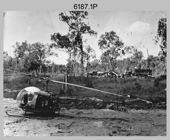
Photograph - Bell 47G-2 helicopter used in Royal Australian Survey Corps Field Operations, c1965
... From 1964 an Aerodist MRC2 airborne Electronic Distance Measuring (EDM) system was extensively used for topographic surveys over long distances by trilateration to replace traverse requiring survey station intervisibility. ...From 1964 an Aerodist MRC2 airborne Electronic Distance Measuring (EDM) system was extensively used for topographic surveys over long distances by trilateration to replace traverse requiring survey station intervisibility. ...This is a set of four photographs of Bell 47G-2 helicopters used in Royal Australian Survey Corps Field Operations. c1965. From 1957, helicopter transport of survey parties revolutionised transport in remote areas. The most common helicopter used by the Royal Australian Survey Corps at this time was the civilian Bell 47G-2 and the Sioux, the Australian Army’s equivalent. From 1964 an Aerodist MRC2 airborne Electronic Distance Measuring (EDM) system was extensively used for topographic surveys over long distances by trilateration to replace traverse requiring survey station intervisibility. In 1965 the command field survey unit personnel attached to the Army Survey Regiment’s Topographic Squadron were used mainly in support roles such as station clearing, tower operations, station monumenting, Aerodist computations, forward base operations, geodetic observations on the north-south traverse and logistic support for Remote teams. .1P is a photo of a civilian Bell 47G-2 helicopter Registration / Serial VH-UTB owned by Helicopter Utilities from Mascot, NSW c1965. In the background of this photograph is three personnel and vehicles at a field survey camp. The left-hand vehicle is a Willys Jeep with trailer and on the right is probably a Truck, 2 1/2 ton, 6x6, General Service GMC. The Bell 47G-2: VH-UTB was destroyed, and its pilot killed in tragic circumstances during a civilian survey operation on Cape York Peninsula in June 1966. .2P is a photo of a a civilian Bell 47G-2 helicopter Registration / Serial VH-IHB taken in Wyndham, WA. As the letters ‘TAA’ appear on the fuselage, the helicopter was charted from Trans Australian Airways. .3P is a photo of a Bell 47G-2: VH-UTC with survey camp in background. .4P is a photo of a Bell 47G-2 equipped with floats and unidentified personnel loading stores, possibly in Darwin. Acknowledgement: Royal Australian Survey Corps – Aerodist Years 1964-1975 Version 2021.0 Authored by Peter Jensen.This is a set of four photographs of civilian Bell 47G-2 helicopters used in Royal Australian Survey Corps Field Operations. c1965. The photographs were printed on photographic paper and are part of the Army Survey Regiment’s Collection. The photographs were scanned at 300 dpi. .1) - Photo, black & white, c1965, Bell 47G-2 helicopter: VH-UTB with survey camp in background. .2) - Photo, black & white, c1965, Bell 47G-2 helicopter: VH-IHB with survey station in foreground. .3) - Photo, black & white, c1965, Bell 47G-2 helicopter: VH-UTC with survey camp in background. .4) - Photo, black & white, c1965, Bell 47G-2 helicopter: Unidentified personnel loading stores possibly in Darwin..2P – annotated on bottom of photo ‘Wyndham Area – Helicopter drops observing party’ The other photographs are not annotated.royal australian survey corps, rasvy, army survey regiment, army svy regt, fortuna, asr, surveying -
 Department of Energy, Environment and Climate Action
Gunter's Chain
... Gunter's chain was used for measuring distance in surveying. It was designed and introduced in 1620 by English clergyman and mathematician Edmund Gunter (1581–1626). ...Gunter's chain was used for measuring distance in surveying. It was designed and introduced in 1620 by English clergyman and mathematician Edmund Gunter (1581–1626). ...Before metrication was introduced into Australia in the 1970s land was measured in chains and links. Many old parish plans show length measurements in chains and links. Area was shown in acres, roods and perches. Gunter's chain was used for measuring distance in surveying. It was designed and introduced in 1620 by English clergyman and mathematician Edmund Gunter (1581–1626). Gunter developed the measuring chain of 100 links. The chain and the link, became statutory measures in England and subsequently the British Empire. After metrication units of length were measured in meters and area in hectares. The chain was later superseded by steel ribbon tape.The 66-foot long (1 chain) Gunter's Chain was a fundamental instrument for land surveying. It is divided into 100 links (each 7.92 inches long) which are marked off into groups of 10 by brass tags with 'fingers' to indicate 10, 20, 30, 40 and 50 links from the hand grips, thus simplifying intermediate measurements. Each end of the chain is fitted with a brass hand grip. It was heavy and sturdy enough to be dragged through the bush and over rough terrain on surveying transects. Giving rise to the common forestry term "chainman" for the person tasked with dragging it. 1 chain = 100 links = 22 yards = 66 feet = 792 inches = 4 rods, poles or perches. 10 chains = 1 furlong 80 chains = 1 mile 1 acre = 10 square chains = 4 roods = 160 square rods, poles or perches.forest measurement, surveying, forests commission victoria (fcv) -
Frankston RSL Sub Branch
Magnifier, Map Reading
... When unfolded this forms a "U" shape with the glass lens positioned conveniently for map viewing and the base can be used to measure scaled distances....When unfolded this forms a "U" shape with the glass lens positioned conveniently for map viewing and the base can be used to measure scaled distances. Magnifier, Map Reading ...A small pocket size folding magnifier used for enlarging detail when reading maps or examining aerial photographs complete with a leather storage pouch. Manufactured of brass by Casartelli of Manchester, England. When unfolded this forms a "U" shape with the glass lens positioned conveniently for map viewing and the base can be used to measure scaled distances.This item is stamped "CASARTELLI, MANCHESTER" and has 1/4, 1/2 and 1 inch markings. -
 Bendigo Military Museum
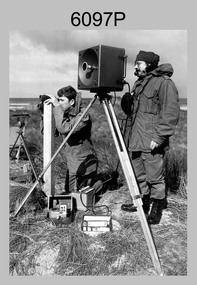
Photograph - Army Survey Regiment Personnel – Mahogany Ship Survey, Warrnambool, VIC, 1985
... CPL Mark Lander and SGT Don Williams were taking electronic distance measurements using an MRA-301 tellurometer. To measure the distance, personnel at another site operating another MRA-301 tellurometer would have exchanged the signal emission. ...CPL Mark Lander and SGT Don Williams were taking electronic distance measurements using an MRA-301 tellurometer. To measure the distance, personnel at another site operating another MRA-301 tellurometer would have exchanged the signal emission. ...This is a photograph of Army Survey Regiment personnel undertaking surveying measurements during a search for the ‘Mahogany Ship’ Warrnambool, VIC on 3rd September1985. CPL Mark Lander and SGT Don Williams were taking electronic distance measurements using an MRA-301 tellurometer. To measure the distance, personnel at another site operating another MRA-301 tellurometer would have exchanged the signal emission. A ‘Hilga Watts’ light appears in the background and a barometer in the foreground.This is a photograph of Army Survey Regiment personnel undertaking surveying measurements during a search for the ‘Mahogany Ship’ Warrnambool, VIC on 3rd September1985. The photograph was printed on photographic paper and is part of the Army Survey Regiment’s Collection. The photograph was scanned at 300 dpi. L to R: CPL Mark Lander, SGT Don Williams‘R.S. 3/9/1985 CPL Mark Lander, SGT Don Williams PIC BY COURTESY OF THE WARRNAMBOOL STANDARD’ annotated on back of photoroyal australian survey corps, rasvy, army survey regiment, army svy regt, fortuna, asr, surveying -
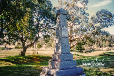 Eltham District Historical Society Inc
Photograph, Hume and Hovell Monument, Broadford, Autumn Excursion, Hume and Hovell's 1824 expedition, 26 May 1996, 26/05/1996
... Because their distance-measuring wheel had broken and a one degree mistake was made in calculations, the two leaders of the original group of six convict-companions arrived at Corio Bay, instead of the expected Western Port, discovered earlier by Flinders. ...Because their distance-measuring wheel had broken and a one degree mistake was made in calculations, the two leaders of the original group of six convict-companions arrived at Corio Bay, instead of the expected Western Port, discovered earlier by Flinders. ...[article by Bettina Woodburn in EDHS Newsletter No. 109, July 1996:] ON THE TRAIL OF HUME AND HOVELL - REPORT ON THE AUTUMN EXCURSION - On a green and fresh morning (Sunday 26th May 1996) the Cobb and Co coach (driven by the most obliging Peter Tampion) set off in a north easterly direction from Eltham to connect with Hume and Hovell's route on their 1824 explorations of central Victoria. The Society would follow a series of monuments erected for the 1924 centenary of the expedition from King Parrot Creek (Tuesday 7th December 1824), through Strath Creek, over Sunday Creek (Sunday 12th December 1824) at Broadford, Tullamarine, St Albans, Deer Park, through Werribee, skirting east of the You Yangs to Lara and Avalon Beach. Because their distance-measuring wheel had broken and a one degree mistake was made in calculations, the two leaders of the original group of six convict-companions arrived at Corio Bay, instead of the expected Western Port, discovered earlier by Flinders. From below Mt. Disappointment (Hume and Hovell's difficulties in "scrambling over brush and rock", "leeches in forest, as well as no water", "cutting grass 4-5 ft. high", dreadful scrub", "devil flies") we took an easier route, saw the Strath Creek memorial in ground fog and a wonderful "field of dreams", the Hume-Hovell privately owned cricket ground with its white picket boundary fence. Now, after a steep climb, in sunshine under gums we stretched and viewed magnificent rolling hills and fog-filled valleys - not "smoke from Aborigines' bush fires". After morning tea at Broadford we followed the Sunday Creek valley beside the Hume Freeway, passed the Wallan Wallan Rest Area (more appropriately Hume and Hovell Rest Area) to tum right at Beveridge. In Gellibrand Hill Park, near the headwaters of the Moonee Ponds Creek, we experienced the landscape the first European settlers saw - huge river red gums and rolling pastures. The gardens and sheltered courtyard of the 1840s, timber, brought from .....[?] prefabricated Woodlands Homestead, provided a pleasant lunch stop. We enjoyed a private tour, panoramic views over Melbourne and surroundings and the excitement of arriving and departing aircraft. Our next river crossing was at Werribee, "in a vast treeless plain", then we drove on by-ways no coach had previously travelled, to find "an immense sheet of water" salty Corio Bay, off-course to the west. In late afternoon of a super, calm, late autumn day we headed homewards. Back at Eltham we were rather surprised to find that we had travelled a total of 347 km. Thanks again to Russell Yeoman for his research and organization. What a wonderful day! Colour photographactivities, broadford, hume and hovell, monument