Showing 62296 items matching "documents-maps"
-
 Federation University Historical Collection
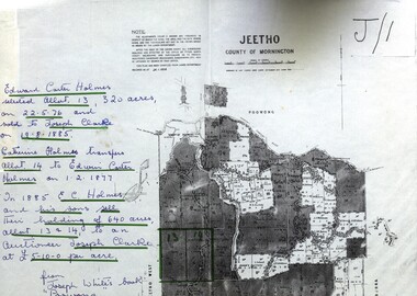
Map - Documents, Documents relating to Land - Selection of Maps of subdivisions; Titles; Cemetery sections
... Documents ...Documents relating to Land - Selection of Maps of subdivisions; Titles; Cemetery sections...Map...Maps indicate the land owned in various areas of Victoria - Mornington Peninsula, Ascot / Creswick area...Land maps showing block divisions and owners. Edward Carter Holmes J.P. selected land and called it Launchley - later called Wambalano....Edward Carter Holmes J.P. selected land and called it Launchley - later called Wambalano. Documents relating to Land - Selection of Maps of subdivisions; Titles; Cemetery sections Map Documents ...Maps indicate the land owned in various areas of Victoria - Mornington Peninsula, Ascot / Creswick areaLand maps showing block divisions and owners. Edward Carter Holmes J.P. selected land and called it Launchley - later called Wambalano.jeetho, county of mornington, edward carter holmes, joseph clarke, catherine holmes, talbot, william coghill, pre-emptive right, tourello pre-emptive right, glendonald pre-emptive right, clunes, smeaton, ascot, counties of ripon and talbot, certificate of title, ballaarat general cemetery, new cemetery, poowong, helen coghill -
 Melbourne Tram Museum
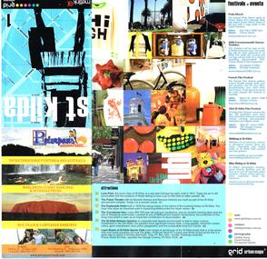
Pamphlet, Grid Urban Maps, "St Kilda grid urban maps", mid 2000's
... "St Kilda grid urban maps"...... Maps...Published by Grid Urban Maps - www.gridmaps.com.au - not functioning at 15/1/2019....Grid Urban Maps..."St Kilda grid urban maps" Pamphlet Grid Urban Maps ...Pamphlet - 12 fold sheet, full colour, titled "St Kilda grid urban maps" showing a map of St Kilda area, public transport routes, locations, description of attractions, festivals, events, and retail and food outlets with a small entry for each advertiser. Has Metlink logo. Published by Grid Urban Maps - www.gridmaps.com.au - not functioning at 15/1/2019.trams, tramways, st kilda, maps, events, public transport -
 Federation University Historical Collection
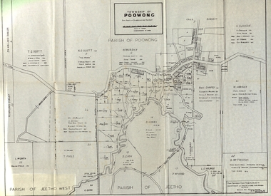
Document - Documents and maps, Holmes - Documents, Letters, Family Trees, Maps
... Holmes - Documents, Letters, Family Trees, Maps...Document...Letters and maps and information relating to the Holmes family of Ascot, Victoria. ...Documents include: Sarah Holmes inquest Ancestors of Elizabeth Mary Holmes Holmes Family Reunion at Arawata Hall Holmes - Documents, Letters, Family Trees, Maps Document Documents and maps ...Letters and maps and information relating to the Holmes family of Ascot, Victoria. Documents include: Sarah Holmes inquest Ancestors of Elizabeth Mary Holmes Holmes Family Reunion at Arawata Hallelizabeth mary holmes, ascot residence tender notice, family tree, map of poowong township, family history, genealogy, samuel pickford, william pickford, elizabeth cross, charles robbins, harry holmes, edith pickford, ian coghill holmes, elizabeth fry -
 Greensborough Historical Society
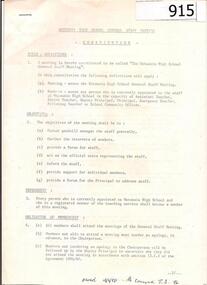
Documents, Watsonia High School documents 1986-1989, 1986-1989
... Documents...Watsonia High School documents 1986-1989....Document 1 is the constitution of Staff Meetings at Watsonia High School; document 2 outlines the programs and budgets for Watsonia High in 1989; document 3 is a profile of Watsonia High in 1986....3 documents, total approx 26 pages. ...Name written in pen on cover of one document....Watsonia High School documents 1986-1989. Documents Watsonia High School ...Document 1 is the constitution of Staff Meetings at Watsonia High School; document 2 outlines the programs and budgets for Watsonia High in 1989; document 3 is a profile of Watsonia High in 1986.Administration information for staff and parents of Watsonia High School.3 documents, total approx 26 pages. Name written in pen on cover of one document.watsonia high school -
 Lara RSL Sub Branch
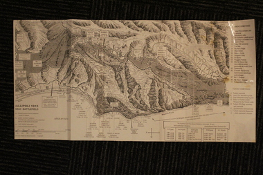
Group of Maps World War One, Group of Maps World War One - Dardanelles and Anzac Gallipoli Maps Circ 1915, Circ 1916
... Group of Maps World War One - Dardanelles and Anzac Gallipoli Maps Circ 1915...Gallipoli 1915 Maps and Naval plan of Operations World War One ANZAC...Black & White 6. Color Map of ANZAC positions with topographical Details, notes. ...Australian War Memorial, 6. Map of ANZAC positions of World War One, Gallipoli 1915. ...Group of Maps World War One - Dardanelles and Anzac Gallipoli Maps Circ 1915 Group of Maps World War One ...Gallipoli 1915 Maps and Naval plan of Operations World War One ANZACRare examples that explain both ANZAC and Naval Operations during World War One Gallipoli & Dardanelles Passage .!. Black and White Photocopy of Gallipoli 1915 ANZAC Battlefield - detailed positions of troops and Cemeteries. 2.The Allied Failure to Force The Dardanelles Passage 18 March 1915 - detailed line of Attack Naval Organisation, Mine layout, Plan of Attack (and copy).. 3. Map of Turkey and surrounding area written in Turkish and German Languages. C0olor version main roads and distances. (and copy).. 4. Map of ANZAC Trench Diagram. World War One.Color. (and copy). 5.Panorama of Chunuk Blair from 3 miles south of Nibrunesi Point, 3 November 1915 and Anzac from 1 mile N. E. of Ari Burnu, 21 November 1915. Black & White 6. Color Map of ANZAC positions with topographical Details, notes. 1. Artwork and copyright by Srewart Cownie, Gallipoli 1915 ANZAC Battlefield with Landings and later evacuation marked. 2. Details of Naval actions taken in the Dardanelles Passage 18 March 1918. 3. Local area Map or Turkey. Shows roads network and townships. 4. ANZAC Trench Diagram, copyright Whitcombe & Tombs Limited , Wellington N.Z. 1919 5. Panorama of two coast views of ANZAC area. Australian War Memorial, 6. Map of ANZAC positions of World War One, Gallipoli 1915. Published by H.E.C. Roberinson, George Street, Sydney N.S.W.18 April 1916maps operational of anzac and naval opations during 1915 etc, dardanelles naval opations -
 Mission to Seafarers Victoria
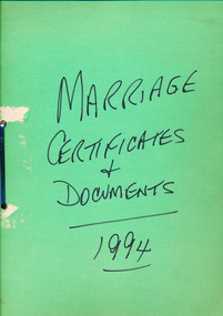
legal record (item) - Register and Documents, Marriage Register + Documents 1994, Circa 1994
... Marriage Register + Documents 1994...All these documents are unused....A large green paper folder containing many blank documents used in connection with weddings....Handwritten on the front cover: MARRIAGE / CERTIFICATES / + / DOCUMENTS (underlined) / 1994 (underlined)....A large green paper folder containing many blank documents used in connection with weddings. Marriage Register + Documents 1994 legal record Register and Documents ...The folder contains two different government brochures designed for couples planning to be married (two of each) - titled "Approved Organisations Offering Programs of Marriage Counselling and Marriage Education" and "Happily Ever... Before and After", four small and nineteen large envelopes marked "Certificate of Marriage", twenty-three Certificates of Marriage, twenty-nine Notice of Intended Marriage documents, twenty-one Consent to Marriage of Minor documents, and one Marriage Register. All these documents are unused.A collection of documents used in the preparation and ceremony of a wedding.Handwritten on the front cover: MARRIAGE / CERTIFICATES / + / DOCUMENTS (underlined) / 1994 (underlined).marriage, register, 1994, brochure, official-documents, dio-marriages, marriages -
 Lara RSL Sub Branch
Silk Maps, Four Collective maps
... Four Collective maps...Map 1....Silk Fabric ... "Western Pacific.Map 2....Silk fabric....Hong Kong /Canton.Map 3Cloth Map East Java South West Pacific.Map 4....Arakan/Irrawaddy fabric map.M...Map 4....Restricted..Edition 1 -gsgsFabric Map 1;1,000,000 Map 3....No 25 Timor/No 26 East Java .Map 2 Hong Kong/Canton restricted MAP 1,NACI - HO. ...Lara RSL Sub Branch McClelland Ave Lara Scientific or research signifigance. Map 4....Restricted..Edition 1 -gsgsFabric Map 1;1,000,000 Map 3....No 25 Timor/No 26 East Java .Map 2 Hong Kong/Canton restricted MAP 1,NACI - HO. ...Scientific or research signifigance.Map 1....Silk Fabric ... "Western Pacific.Map 2....Silk fabric....Hong Kong /Canton.Map 3Cloth Map East Java South West Pacific.Map 4....Arakan/Irrawaddy fabric map.MMap 4....Restricted..Edition 1 -gsgsFabric Map 1;1,000,000 Map 3....No 25 Timor/No 26 East Java .Map 2 Hong Kong/Canton restricted MAP 1,NACI - HO. No.S 12. -
Warrnambool and District Historical Society Inc.
Document (collection) - Legal papers 1885-1951 from William Ardlie and John Ardlie, Legal Documents Ardlie
... Legal Documents Ardlie...Document...A collection of legal documents from 1888-1951...There are a large number of signatories to the various letters and documents....The collection contains invoices, wills, mortgage and assignment notices from 1888 until 1950 as well as handwritten letters regarding matters related to the division of land and assets.Among them are names of many well known Warrnambool families and early pioneers such as Cassady, Bowman,Beattie Murfitt, Carroll, McPhee, McGinness, O'Brien, Carey , Hunt, Cole Parker, Hetherington, McKenna, Clifford,Hocking, Begley, These papers are valuable for research in family history as well as property and social connections.They have strong provenance and are a valuable primary source of historical information. cassady hurst bower kearns molan ardlie briggs drought russell hose melican dallimore kerr fogarty harwood foley bowman beattie o'keeffe keys baudinette brennan clifford mcphee degraff carroll mcginness johnson murfitt carey o'brien walsh cole hunt parker hetherington dumsney whitton paech ernest ardlie hocking young There are a large number of signatories to the various letters and documents. A collection of legal documents from 1888-1951 Legal Documents Ardlie Document Legal papers 1885-1951 from William Ardlie and John Ardlie ...John ArdlieTo record legal matters between clients , government departments and family entities.Legal paperscassady, hurst, bower, kearns, molan, ardlie, briggs, drought, russell, hose, melican, dallimore, kerr, fogarty, harwood, foley, bowman, beattie, o'keeffe, keys, baudinette, brennan, clifford, mcphee, degraff, carroll, mcginness, johnson, murfitt, carey, o'brien, walsh, cole, hunt, parker, hetherington, dumsney, whitton, paech, ernest ardlie, hocking, youngcassady, hurst, bower, kearns, molan, ardlie, briggs, drought, russell, hose, melican, dallimore, kerr, fogarty, harwood, foley, bowman, beattie, o'keeffe, keys, baudinette, brennan, clifford, mcphee, degraff, carroll, mcginness, johnson, murfitt, carey, o'brien, walsh, cole, hunt, parker, hetherington, dumsney, whitton, paech, ernest ardlie, hocking, young -
 Emerald Museum & Nobelius Heritage Park
Map - Map & Caveat relating to Maurice john & Deirdre Joy Morgan 6 January, 1984, transfer forbid to Robert John Woodward, Legal Documents and Map relative to action between M & D Morgan and R Woodward property adjacent to Belgrave-Genbrook Rd., Emerald 1984, c1984
... Legal Documents and Map relative to action between M & D Morgan and R Woodward property adjacent to Belgrave-Genbrook Rd., Emerald 1984...Map...Images of Legal Documents and Map relative to action between M & D Morgan and R Woodward property adjacent to Belgrave-Genbrook Rd., Emerald 1984...4 images depicting legal instruments and maps relative to M & D Morgan and R Woodward 1984 for properties adjacent to Belgrave-Gembrook Rd., Emerald (3 further difficult to read small maps attached to main file...Emerald Museum & Nobelius Heritage Park 5 Crichton Rd Emerald yarra-valley-and-the-dandenong-ranges 4 images depicting legal instruments and maps relative to M & D Morgan and R Woodward 1984 for properties adjacent to Belgrave-Gembrook Rd., Emerald (3 further difficult to read small maps attached to main file Images of Legal Documents and Map relative to action between M & D Morgan and R Woodward property adjacent to Belgrave-Genbrook Rd., Emerald 1984 Legal Documents and Map relative to action between M & D Morgan and R Woodward property adjacent to Belgrave-Genbrook Rd., Emerald 1984 Map Map & Caveat relating to Maurice john & Deirdre Joy Morgan 6 January, 1984, transfer forbid to Robert John Woodward ...Images of Legal Documents and Map relative to action between M & D Morgan and R Woodward property adjacent to Belgrave-Genbrook Rd., Emerald 19844 images depicting legal instruments and maps relative to M & D Morgan and R Woodward 1984 for properties adjacent to Belgrave-Gembrook Rd., Emerald (3 further difficult to read small maps attached to main file -
Warrnambool and District Historical Society Inc.
Map (series) - Local Parish Maps, Local Government maps 1942 and three fire maps
... Local Government maps 1942 and three fire maps....Map...The fire maps would have been used by CFA to locate areas of fire problems . ...The fire maps are South and North regions....Map Local Parish Maps. ...These show the Western District in detail with property owners named . The fire maps have properties which are numbered.western district maps, belfast, brucknell, caramut, cooramook, framlingham east, framlingham west, garvoc, laang, kangertong, meerai, minjah north, minjah, minhamite, nullawarre, narrawaturk, nirranda, paaratte, panmure, purnim, quamby north, tallangatta, quamby, timboon, wangoom, willatook, woolsthorpe, yangery, yarpturk, ecklin, yeth- youang.western district maps, belfast, brucknell, caramut, cooramook, framlingham east, framlingham west, garvoc, laang, kangertong, meerai, minjah north, minjah, minhamite, nullawarre, narrawaturk, nirranda, paaratte, panmure, purnim, quamby north, tallangatta, quamby, timboon, wangoom, willatook, woolsthorpe, yangery, yarpturk, ecklin, yeth- youang. -
 Ballarat Tramway Museum
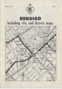
Map, Royal Automobile Club of Victoria, "Bendigo Including city and district maps - RACV", c1968
... "Bendigo Including city and district maps - RACV"...... Map...Map...Printed street map titled "Bendigo Including city and district maps", published by the RACV, showing the central part of Bendigo on the front cover, Bendigo Outlets and notes on the city itself. ...in ink on the Bendigo Outlet map, has various notes showing the location of crossing loops on and off the map and the location of the tram depot itself...."Bendigo Including city and district maps - RACV" Map Royal Automobile Club of Victoria ...Printed street map titled "Bendigo Including city and district maps", published by the RACV, showing the central part of Bendigo on the front cover, Bendigo Outlets and notes on the city itself. Has the tram lines shown dotted, only shows the full extent of the Golden Square line. Inside has a district road map. The front cover has the number "0468" in the bottom left hand corner, indicating the publication date.in ink on the Bendigo Outlet map, has various notes showing the location of crossing loops on and off the map and the location of the tram depot itself.trams, tramways, map, bendigo, racv, railways -
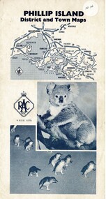 Phillip Island and District Historical Society Inc.
Map, Phillip Island District and Town Maps, 01/11/1967
... Phillip Island District and Town Maps ...Map...Map - PI District and Town Maps - Tourist brochure. ...Map-Phillip Island and District Maps - Tourist guide to Phillip Island tourist sites. ...Map - PI District and Town Maps - Tourist brochure. ...Map - PI District and Town Maps - Tourist brochure. Produced by the RSCV.HistoricalMap-Phillip Island and District Maps - Tourist guide to Phillip Island tourist sites. A3 page folded as a brochure. Blue print and photographs and advertisements.historical society -
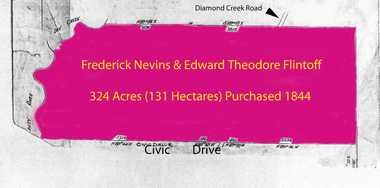 Greensborough Historical Society
Folder of documents, Flintoff - various documents, 1844_
... Flintoff - various documents...Various photocopies of title documents relating to land owned by the Flintoff family in Greensborough....Mainly handwritten documents dating from early 20th century....Flintoff - various documents Folder of documents ...Records the Flintoff family's ownership of parcels of land in the Greensborough area. Includes a survey plan for acquisition of land for the aqueduct 1897.Various photocopies of title documents relating to land owned by the Flintoff family in Greensborough.Mainly handwritten documents dating from early 20th century.flintoff family, land titles, greensborough, aqueduct -
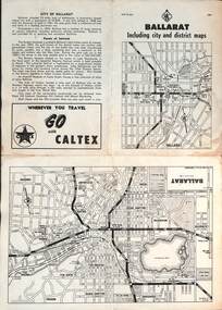 Ballarat Tramway Museum
Map, RACV - Royal Automobile Club of Victoria, "Ballarat including city and district maps", 10/1961
... "Ballarat including city and district maps"...Map...Map...Each map in the bottom left-hand corner has the number "1061", possibly indicating the date. ...Four fold map printed on white paper, titled "Ballarat including city and district maps" - Map No. ...MAP 15.314 and dated 10-61. Produced by the RACV "Ballarat including city and district maps" Map RACV - Royal Automobile Club of Victoria ...Shows the central part of Ballarat, Ballarat Outlets, streets, principal attractions, Ballarat and district maps and information. Has the tram lines shown dotted, does not run out to Sebastopol or the Lydiard St North terminus. Each map in the bottom left-hand corner has the number "1061", possibly indicating the date. Has notes on the City, points of interest, and an advertisement for Caltex. See item 4929 for a larger version dated 1966. Yields information about the extent of Ballarat in the early 1960's shows the tram lines and other rail lines in the district. Four fold map printed on white paper, titled "Ballarat including city and district maps" - Map No. MAP 15.314 and dated 10-61. Produced by the RACVmap, tranways, ballarat, racv, railways -
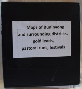 Buninyong Visitor Information Centre
Document (item) - Information Folder, Maps of Buninyong and Surrounding Districts, 1990s
... Maps of Buninyong and Surrounding Districts...Maps...Document...Collection of maps and copies of maps of the Buninyong district....Black vinyl covered ring binder with plastic pockets containing maps and historical articles....Maps of Buninyong and Surrounding Districts Document Information Folder ...Collection of maps and copies of maps of the Buninyong district.maps, mapping, buninyong -
 Bacchus Marsh & District Historical Society
Map, Bacchus Marsh Township and Nearby Districts Maps Volume
... Bacchus Marsh Township and Nearby Districts Maps Volume...Maps...Map...This volume of maps is believed to have been compiled by staff at the Shire of Bacchus Marsh and was presumably used to inform and assist Shire staff and Councillors in the carriage of their duties....There are 81 maps in total. Map 1 Liquidators Sale 1896. ...Map 2. Woodside Estate Sale 1913. Bacchus Marsh Township and Nearby Districts Maps Volume Map ...This volume of maps is believed to have been compiled by staff at the Shire of Bacchus Marsh and was presumably used to inform and assist Shire staff and Councillors in the carriage of their duties.This collection of maps are significant due to their rarity as many of them are unique maps made for local purposes in the Bacchus Marsh region. They are also of strong research value containing a wide variety of information including landholders, land sales, infrastructure, such as roads, bridges, public, commercial and private buildings, houses, land use, and geographic features over multiple decades from the late nineteen century into the middle part of the twentieth century.One bound volume of maps comprising cadastral maps, (indicating property owners and land boundaries), land plans and real estate auction plans and advertising material, and other maps indicating major infrastructure like proposed roads and irrigation areas. Most of the maps and plans are of Bacchus Marsh and nearby areas but some maps are of nearby towns such as Melton, Ballan and Blackwood. The volume comprises 52 pages. Most pages have a single map or plan pasted onto it but some contain 2 or 3 different maps. There are 81 maps in total. Map 1 Liquidators Sale 1896. Map 2. Woodside Estate Sale 1913. maps, maps bacchus marsh, maps bacchus marsh region -
Whitehorse Historical Society Inc.
Map, Directory Maps of the County of Bourke, 1892
... Map...Directory Maps of the County of Bourke...Maps...Map...Bonney for the Victorian Shire Map Company. Scale: 40 chains to the inch....Directory maps of the County of Bourke, containing all the Parishes ... also a complete map of the Colony of Victoria, showing all the Counties, Parishes, Railways and stations to date, and the Mallee Blocks. ...Directory Maps of the County of Bourke Map Map ...Directory maps of the County of Bourke, containing all the Parishes ...Directory maps of the County of Bourke, containing all the Parishes ... also a complete map of the Colony of Victoria, showing all the Counties, Parishes, Railways and stations to date, and the Mallee Blocks. Lithographed by G.S.B. Bonney for the Victorian Shire Map Company. Scale: 40 chains to the inch.Directory maps of the County of Bourke, containing all the Parishes ...maps, victoria. county of bourke, t.r.b. morton & son -
 Lara RSL Sub Branch
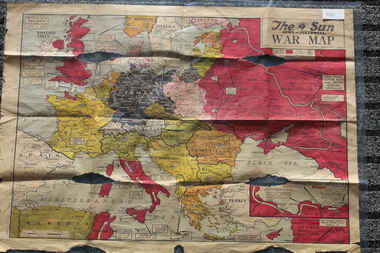
Newspaper - The Sun Newspaper Dated 5/8/1944 -specia - World War 2 Europe Map and History Of World War 2 and Nazi Tide Flows and Ebbs Across Europe, THe Sun Newspaper Dated 5/8//1944 - Special War Maps
... THe Sun Newspaper Dated 5/8//1944 - Special War Maps...Local Newspaper Dated 5/8/1944 - Special World War 2 Maps... World War 2 Europe Map and History Of World War 2 and Nazi Tide Flows and Ebbs Across Europe...Lara RSL Sub Branch McClelland Ave Lara The Sun Newspaper Dated 5/8/1944 world war 2 europe map and hisytory of world war 2 and nazi tide flows and ebbs across europe World War 2 Europe Map and History Of World War 2 and Nazi Tide Flows and Ebbs Across Europe Local Newspaper Dated 5/8/1944 - Special World War 2 Maps THe Sun Newspaper Dated 5/8//1944 - Special War Maps Newspaper The Sun Newspaper Dated 5/8/1944 -specia - World War 2 Europe Map and History Of World War 2 and Nazi Tide Flows and Ebbs Across Europe ...The Sun Newspaper Dated 5/8/1944 Local Newspaper Dated 5/8/1944 - Special World War 2 Maps World War 2 Europe Map and History Of World War 2 and Nazi Tide Flows and Ebbs Across Europeworld war 2 europe map and hisytory of world war 2 and nazi tide flows and ebbs across europe -
 Melbourne Tram Museum
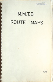
Map, Melbourne & Metropolitan Tramways Board (MMTB), MMTB Route Maps, 1979
... MMTB Route Maps......maps...Map...Series of colour maps for various tram and bus routes, dated 1979. ...Book - brown comb binding, card and clear plastic covers containing both bound and unbound maps and documents....Book - brown comb binding, card and clear plastic covers containing both bound and unbound maps and documents. MMTB Route Maps Map Melbourne & Metropolitan Tramways Board (MMTB) ...Series of colour maps for various tram and bus routes, dated 1979. Also contained, not scanned are letters, reports, and specifications for printing these maps for use in shelters etc. Some have the Transport Information Centre telephone printed on them. Some are finished with a plastic laminate finish on either one or both sides. Show the major cross streets, parks, schools, other tram routes, major stop numbers, and railway lines. See also item 3909 for another example of these. Trams 1 - City route guide - R9/77 - showing all route numbers and destinations that passed through the CBD. 2 - Bourke St tram routes - R4/77 - East Brunswick Blyth St and East Preston Tyler St and intermediate routes, routes 95, 96, 97, 90, 89 and 88. 3 - Malvern, East Malvern, Carnegie, and East Brighton Tram Routes (from St Kilda Junction) - R1/79 - shows routes 5, 3, 67, 66, 61, 62, and 64. 4 - Elizabeth St tram routes - R12/77 - Essendon Airport, West Maribyrnong, North Coburg lines, routes 50, 58, 60, 54, 57, 52. 49, 59, 18, 20 and 19 5 - Flinders St tram routes - R5/78 - North Balwyn, East Burwood, routes 48, 40, 41, Hartwell, 28, 74 and 75 6 - Kew - St Kilda Beach - R1/79 - Route 69. 7 - Mont - Albert City - R11/77, shows routes 43. 47. 45. 44 8 - St Kilda Rd Tram Routes R12/77 - details South Melbourne Beach, route 1 and route 2 and St Kilda Beach routes 15, 16, and 55 otherwise shows where the various routes branch off St Kilda Road 9 - Batman Ave tram routes - R9/77 - Wattle Park, North Richmond and Prahran - routes 70, 71, 78 and 79. 10 - Footscray - Moonee Ponds - R3/81 - Route 82 11 - Swanston St tram guide - R1/79 - lists all routes and route numbers that branch or cross Swanston St between Grattan St and St Kilda Junction. 12 - Toorak Camberwell and Glen Iris tram route with Camberwell Junction and Malvern Town Hall, R1/79, routes 8, 7, 6, 72, and 73 shown. 13 - West Preston - Beach tram routes - R12/77 - routes 10, 11, 9 and 12, 14 - William St tram routes - R12/77 - Route 55, 56, and 63 - South Melbourne Depot and Domain. Buses 1 - Footscray, Sunshine, Deer Park, Nth Altona & Fishermans Bend - R2/79 2 - Box Hill bus routes to Templestowe, Heidelberg & East Kew - R6/78 - notes superseded by R3/82 3 - Plan of Russell St Melbourne bus departure bays. 4 - Box Hill, Mitcham & Ringwood bus routes to East Doncaster & Warrandyte - R3/82 5 - City - Warrandyte & East Doncaster bus routes - R3/82 & R6/78 6 - Bulleen - City - Port Melbourne - Garden City Bus route - R6/78 7 - North Altona - City bus route - 11/78 8 - Clifton Hill - Elsternwick - R2/79 9 - La Trobe - Northland - West Heidelberg - City Bus Service via East Freeway - 11/79 and R3/81 10 - Box Hill, Mitcham & Ringwood Bus Routes to East Doncaster & Warrandyte - R10/84 - with the Metropolitan Transit logo.Yields information about tram and bus routes in late 1970s early 1980s.Book - brown comb binding, card and clear plastic covers containing both bound and unbound maps and documents.K C Painter on front cover in ink.tramways, mmtb, tram routes, maps, bus routes, route numbers, routes, route guide -
 Lara RSL Sub Branch
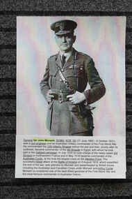
Work on paper - Internet research for World War 1 - Pictures and Maps 1918, World War 1 - Pictures and Maps 1918
... World War 1 - Pictures and Maps 1918...Internet Research printouts of World War 1 details - General Sir John Monash portrait, Maps of Battles etc...General Sir Jon Monash portrait and details of service, Maps of Battles of Wold War 1 1918 ...Lara RSL Sub Branch McClelland Ave Lara Internet Research material Relevant research material 1918 World War 1 world war 1 - 1918 internet research printed material australian at war 1918 General Sir Jon Monash portrait and details of service, Maps of Battles of Wold War 1 1918 Internet Research printouts of World War 1 details - General Sir John Monash portrait, Maps of Battles etc World War 1 - Pictures and Maps 1918 Work on paper Internet research for World War 1 - Pictures and Maps 1918 ...Internet Research materialRelevant research material 1918 World War 1Internet Research printouts of World War 1 details - General Sir John Monash portrait, Maps of Battles etcGeneral Sir Jon Monash portrait and details of service, Maps of Battles of Wold War 1 1918 world war 1 - 1918 internet research printed material australian at war 1918 -
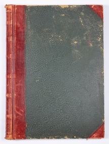
 Bendigo Military Museum
Manual - DRAFT SPECIFICATIONS FOR TOPOGRAPHIC MAP SERIES, Specifications for 1:50000 and 1:25000 maps produced in Australia, Circa 1973
... Specifications for 1:50000 and 1:25000 maps produced in Australia...These draft Specifications set out the Standards for the production of topographic maps within the Commonwealth of Australia at scales of 1:50000 and 1:25000 and are designed to satisfy the basic requirements of both civil and military map users....Hard cover, cloth, Red, 11 Annexes, Supplementary documents....Royal Australian Survey Corps RASvy Fortuna Army Survey Regiment ASR Hard cover, cloth, Red, 11 Annexes, Supplementary documents. Specifications for 1:50000 and 1:25000 maps produced in Australia Manual DRAFT SPECIFICATIONS FOR TOPOGRAPHIC MAP SERIES Royal Ausralian Survey Corps National Mapping Council of Australia ...These draft Specifications set out the Standards for the production of topographic maps within the Commonwealth of Australia at scales of 1:50000 and 1:25000 and are designed to satisfy the basic requirements of both civil and military map users.Hard cover, cloth, Red, 11 Annexes, Supplementary documents.royal australian survey corps, rasvy, fortuna, army survey regiment, asr -
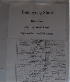 Buninyong Visitor Information Centre
Document (item) - Information Folder, Buninyong Visitor Information Centre Volunteers, Buninyong Shire Mine Maps, 1990s
... Buninyong Shire Mine Maps......Maps...Document...Refer to the photographs of the contents pages for the list of the sixty-one maps in this folder. Maps are not originals and were copied for research purposes only. ...White vinyl covered ring binder with plastic pockets containing copies of maps and gold leads in the Buninyong area....Buninyong Shire Mine Maps Document Information Folder Buninyong Visitor Information Centre Volunteers ...Refer to the photographs of the contents pages for the list of the sixty-one maps in this folder. Maps are not originals and were copied for research purposes only. gold, mining, mines, maps, buninyong, gold leads, mining companies -
Ringwood and District Historical Society
Document, Land Title for George Pratt, Ringwood, 19th August, 1869. (3 documents)
... Land Title for George Pratt, Ringwood, 19th August, 1869. (3 documents)...Document...Black and white document...Document includes hand written details of License of land to George Pratt. ...Black and white document Land Title for George Pratt, Ringwood, 19th August, 1869. (3 documents) Document ...Black and white documentDocument includes hand written details of License of land to George Pratt. Three separate Land Titles - 10171(a),(b),(c) -show a respective shaded area relevant to each Title. -
 Whitehorse Historical Society Inc.
Map - Civic maps, City of Nunawading, City of Nunawading Maps
... City of Nunawading Maps...Map...The City of Nunawading existed from 1925 to 1994. The maps show its residential holdings. They are undated but likely to have been used just before the City was abolished in 1994. ...8 printed maps of various sizes covering city of Nunawading. ...Scale 1:2500 City of Nunawading Maps Map Civic maps City of Nunawading ...A collection of maps of the City of Nunawading from Diana Coles, City of Whitehorse Community Chest.8 printed maps of various sizes covering city of Nunawading. Scale 1:2500non-fictionA collection of maps of the City of Nunawading from Diana Coles, City of Whitehorse Community Chest. coles diana, civic maps, city of nunawading, whitehorse road, blackburn road -
 Victorian Aboriginal Corporation for Languages
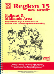
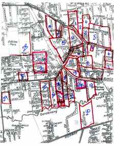
Map, Country Fire Authority, Region 15 rural directory : Ballarat &? Midlands Area : fully detailed maps &? roads index of Ballarat &? the developing areas surrounding, 1996
... Map...Midlands Area : fully detailed maps &? roads index of Ballarat &? the developing areas surrounding...maps...Midlands Area : fully detailed maps &? roads index of Ballarat &? the developing areas surrounding Map Country Fire Authority ...mapsballarat, fire protection, victorian regional maps, emergency services -
 Victorian Aboriginal Corporation for Languages
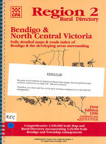
Map, Country Fire Authority, Region 2 rural directory : Bendigo &? North Central Victoria: fully detailed maps &? roads index of Bendigo &? the developing areas surrounding, 1996
... Map...North Central Victoria: fully detailed maps &? roads index of Bendigo &? the developing areas surrounding...maps...North Central Victoria: fully detailed maps &? roads index of Bendigo &? the developing areas surrounding Map Country Fire Authority ...mapsbendigo, loddon, fire protection, victorian regional maps, directories -
 Ringwood and District Historical Society
Document, Collection of copies of Maps relating to Wieland Houses and Properties (most undated), plus Document entitle Brian Pump's Orchard and House Locations, 25/2/2008
... Collection of copies of Maps relating to Wieland Houses and Properties (most undated), plus Document entitle Brian Pump's Orchard and House Locations...Document...Mostly in Heathmont but also Scoresby Most pages are undated and do not have original sources Document 28054 entitled Brian Pump's Orchard and House Locations has notes with maps of various houses with numbers corresponding to those on the included maps and also to those in 28054-003 document ...Mostly in Heathmont but also Scoresby Most pages are undated and do not have original sources Document 28054 entitled Brian Pump's Orchard and House Locations has notes with maps of various houses with numbers corresponding to those on the included maps and also to those in 28054-003 document Collection of copies of Maps relating to Wieland Houses and Properties (most undated), plus Document entitle Brian Pump's Orchard and House Locations Document ...Collection of A4 photocopies of maps and plans, some with yellow highlighting, showing locations of Wieland properties and house including sub-divisions. Mostly in Heathmont but also Scoresby Most pages are undated and do not have original sources Document 28054 entitled Brian Pump's Orchard and House Locations has notes with maps of various houses with numbers corresponding to those on the included maps and also to those in 28054-003 document -
 Stawell Historical Society Inc
Photograph, Sister Rocks Title Documents c 1867
... Sister Rocks Title Documents c 1867...Photographs also show maps of the areas. Information also includes 3 typed pages copied from the documents photographs. ...Documents relating to the Sister Rock's c 1867....Photographs also show maps of the areas. Information also includes 3 typed pages copied from the documents photographs. ...Photographs of title documents related to the Sister’s Rocks. c 1867. In 1866 a photographer Mr. O.G. Armstrong feared the Sister's Rock's would be used for building material. Mr. Armstrong and Samuel John Davidson squatter of Great Western leased the ground around the Rock's under the 42nd section of then existing "Land Act" enclosing the rocks with a rough fence. Davidson's lease application was dated 30th Jan 1867. The area applied for was 10 acres and issued 2nd July 1867. The fee paid 2 pound 10 shillings annually till July 1871 when an application to purchase was lodged. Two years later the land was transferred to the Borough of Stawell. Photographs also show maps of the areas. Information also includes 3 typed pages copied from the documents photographs. Documents relating to the Sister Rock's c 1867.documents relating to sister's rock's -
 Stawell Historical Society Inc
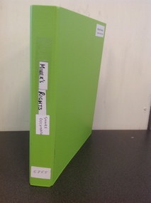
Book, Stawell Historical Society, Miners Rights & Share Documents, 2005
... Miners Rights & Share Documents...Miners Rights (Shared Documents)...Stawell Historical Society Inc 46 Longfield St Stawell grampians Miners Rights for mines in the Stawell stawell gold mining Miners Rights (Shared Documents) Lime Green A4 Ring Binder. Title on white paper on spine Miners Rights & Share Documents Book Stawell Historical Society ...Miners Rights for mines in the StawellLime Green A4 Ring Binder. Title on white paper on spineMiners Rights (Shared Documents)stawell gold mining -
 Greensborough Historical Society
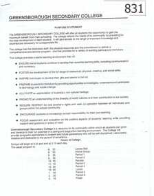
Document, Greensborough Secondary College Documents 1990. Gr8750, 1990_
... Document...Greensborough Secondary College Documents 1990. Gr8750...Document...This collection of documents includes the Greensborough Secondary College Purpose Statement, Counter Disaster Plan and draft Prospectus Statements....Photocopied and stapled documents. ...Greensborough Secondary College Documents 1990. Gr8750 Document Document Greensborough Secondary College ...This collection of documents includes the Greensborough Secondary College Purpose Statement, Counter Disaster Plan and draft Prospectus Statements.These documents are examples of the administration of the 'new' Greensborough Secondary College, formed after the amalgamation of Watsonia High and Watsonia Technical schools.Photocopied and stapled documents. greensborough secondary college, greensborough college