Showing 513 items matching "drain"
-
 Kew Historical Society Inc
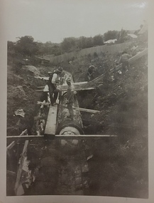
Photograph, City of Kew, City of Kew, Cecil Street Drain, 1936
... City of Kew, Cecil Street Drain...Men at work in the creek bed of Connor's Creek in Kew, while constructing the underground drain. Connor's Creek was one of the two main tributaries of the Yarra River in Kew. ...Inscription on reverse: "City of Kew / Cecil st drain / November 1936". ...City of Kew, Cecil Street Drain Photograph Photograph City of Kew ...An original photograph donated to the Kew Historical Society by the City's Engineering Department following the amalgamation of Kew into the City of Boroondara. While not all of the photographs are of Studley Park, Kew or East Kew, each photo provides a fine snapshot of the work of local government engineering departments of the period. They reveal they types of labour conducted, the techniques used and the equipment and machinery in the possession of the local government authority. Historic and rare photograph of major public works in Kew in the 1930s.Public works. Men at work in the creek bed of Connor's Creek in Kew, while constructing the underground drain. Connor's Creek was one of the two main tributaries of the Yarra River in Kew. It originated somewhere near the grounds of Genazzano FCJ College. The barrel drain was finally completed in 1941 at a cost of £14,000. Inscription on reverse: "City of Kew / Cecil st drain / November 1936". city of kew, city of kew (engineering department), engineering, connor's creek (kew) -
 Kew Historical Society Inc
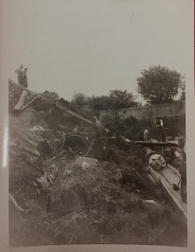
Photograph, City of Kew, City of Kew, Cecil Street Drain, 1936
... City of Kew, Cecil Street Drain...Men at work in the creek bed of Connor's Creek in Kew, while constructing the underground barrel drain. Connors Creek was one of the two main tributaries of the Yarra River in Kew. ...Inscription on reverse: "City of Kew / Cecil st drain / November 1936". ...City of Kew, Cecil Street Drain Photograph Photograph City of Kew ...An original photograph donated to the Kew Historical Society by the City's Engineering Department preceding the amalgamation of Kew into the City of Boroondara. While not all of the photographs are of Studley Park, Kew or East Kew, each photo provides a fine snapshot of the work of local government engineering departments of the period. They reveal they types of labour conducted, the techniques used and the equipment and machinery in the possession of the local government authority. Historic and rare photograph of major public works in Kew in the 1930sPublic works. Men at work in the creek bed of Connor's Creek in Kew, while constructing the underground barrel drain. Connors Creek was one of the two main tributaries of the Yarra River in Kew. It originated somewhere near the grounds of Genazzano FCJ College. The barrel drain was finally completed in 1941 at a cost of £14,000. Inscription on reverse: "City of Kew / Cecil st drain / November 1936". public works (kew), roadmaking, engineering, city of kew (engineering department), connor's creek (kew), cecil street drain -
 Ballarat Heritage Services
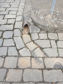
Photograph - Digital photograph, Bluestone gutter and Drain, Lydiard Street South, Ballarat, 2020, 15/02/2020
... Bluestone gutter and Drain, Lydiard Street South, Ballarat, 2020......drain...Colour photograph of a bluestone drain on the corner of Lydiard Street South and Chancery Lane. ...Ballarat Heritage Services PO Box 2209 Bakery Hill Post Office goldfields Bluestone gutters are a feature of the Ballarat Central Business District. bluestone gutter drain lydiard street south Colour photograph of a bluestone drain on the corner of Lydiard Street South and Chancery Lane. ...Bluestone gutters are a feature of the Ballarat Central Business District.Colour photograph of a bluestone drain on the corner of Lydiard Street South and Chancery Lane. bluestone, gutter, drain, lydiard street south -
 Port Melbourne Historical & Preservation Society
Functional object - Timber planking section, Outfall Timber Drain Reconstruction, c. 1927
... Outfall Timber Drain Reconstruction...This section of timber was cut from a large quantity of the abandoned timber outfall drain during reconstruction by Melbourne Water. ...Section of timber cut from part of the old abandoned timber outfall drain at Esplanade East during reconstruction 2004...Made available to the PMH&PS by Paul Balassone. engineering - canals and drainage melbourne water Section of timber cut from part of the old abandoned timber outfall drain at Esplanade East during reconstruction 2004 Outfall Timber Drain Reconstruction Functional object Timber planking section ...This section of timber was cut from a large quantity of the abandoned timber outfall drain during reconstruction by Melbourne Water. Made available to the PMH&PS by Paul Balassone.Section of timber cut from part of the old abandoned timber outfall drain at Esplanade East during reconstruction 2004engineering - canals and drainage, melbourne water -
 Eltham District Historical Society Inc
Work on paper (Sub-Item) - Photograph, St Helena East drain immediately downstream of St Helena Road
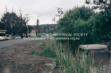
... St Helena East drain immediately downstream of St Helena Road......drain...Colour photograph of St Helena East drain immediately downstream of St Helena Road, Greensborough. ...Eltham District Historical Society Inc 728 Main Rd Eltham melbourne Colour photograph of St Helena East drain immediately downstream of St Helena Road, Greensborough. ...Colour photograph of St Helena East drain immediately downstream of St Helena Road, Greensborough. The house shown is one of the first to be built on the Glen Katherine Estate.eltham, drain, st helena, glen katherine estate, greensborough -
 Ballarat Heritage Services
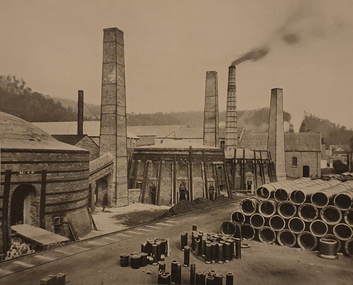
Photograph, Lithgow Brick and Drain-Pipe Works, 1906
... Lithgow Brick and Drain-Pipe Works...Lithgow Brick and Drain-Pipe Works...A brick and pottery works were opened there in 1877 with additional clay also being obtained from deposits near the Mt Clarence Railway Station. lithgow brick and drain-pipe works lithgow Lithgow Brick and Drain-Pipe Works Lithgow Brick and Drain-Pipe Works Photograph ...In 1870 clay deposits were discovered in the Lithgow Valley in the vicinity of the Lithgow Valley Colliery. A brick and pottery works were opened there in 1877 with additional clay also being obtained from deposits near the Mt Clarence Railway Station.Lithgow Brick and Drain-Pipe Workslithgow brick and drain-pipe works, lithgow -
Port Melbourne Historical & Preservation Society
Photograph - Main drain reconstruction, Cruikshank Street, Port Melbourne, Outfall Timber Drain Reconstruction, 23 Aug 2004
... Outfall Timber Drain Reconstruction...Photographs & plans supplied by Melbourne water of Cruikshank Street main drain reconstruction of bay outfall. 2004 .01 19x25 colour photo of clear spanning footing .02 19x25 colour photo of outer edge of drain .03 19x25 colour photo of top deck of drain .04 19x25 colour photo of excavation .05 - .08 19x25 colour photo of excavation of drain .09 - .12 colour photo of excavation of drain .13 - .14 22x33 colour photo of plan of area .15 - .17 39x53 drawn plan of area surrounding .18 - .19 39x53 Cruikshank St main drain reconstruction .20 Initial e-mail letter regarding drain (3-8-04) .21 Business card, Melbourne Water's Paul Balassome...Port Melbourne Historical & Preservation Society Port Melbourne Town Hall 333 Bay Street Port Melbourne melbourne Engineering - Canals and Drainage Cruikshank Street Photographs & plans supplied by Melbourne water of Cruikshank Street main drain reconstruction of bay outfall. 2004 .01 19x25 colour photo of clear spanning footing .02 19x25 colour photo of outer edge of drain .03 19x25 colour photo of top deck of drain .04 19x25 colour photo of excavation .05 - .08 19x25 colour photo of excavation of drain .09 - .12 colour photo of excavation of drain .13 - .14 22x33 colour photo of plan of area .15 - .17 39x53 drawn plan of area surrounding .18 - .19 39x53 Cruikshank St main drain reconstruction .20 Initial e-mail letter regarding drain (3-8-04) .21 Business card, Melbourne Water's Paul Balassome Outfall Timber Drain Reconstruction Photograph Main drain reconstruction, Cruikshank Street, Port Melbourne ...Photographs & plans supplied by Melbourne water of Cruikshank Street main drain reconstruction of bay outfall. 2004 .01 19x25 colour photo of clear spanning footing .02 19x25 colour photo of outer edge of drain .03 19x25 colour photo of top deck of drain .04 19x25 colour photo of excavation .05 - .08 19x25 colour photo of excavation of drain .09 - .12 colour photo of excavation of drain .13 - .14 22x33 colour photo of plan of area .15 - .17 39x53 drawn plan of area surrounding .18 - .19 39x53 Cruikshank St main drain reconstruction .20 Initial e-mail letter regarding drain (3-8-04) .21 Business card, Melbourne Water's Paul Balassomeengineering - canals and drainage, cruikshank street -
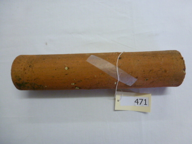 Greensborough Historical Society
Pipe, Terracotta drain pipe (section), 1930c
... Terracotta drain pipe (section)...30 cm length of drain pipe. Terracotta. Orange colour with fragments of white rock. ...Note small Internal diameter (4.5 cm). terracotta pipe greensborough drains 30 cm length of drain pipe. Terracotta. ...Circa 1920-1940, this length of pipe was found in a Greensborough property near the site of a former outbuilding.An example of pipes no longer in use. Note small Internal diameter (4.5 cm).30 cm length of drain pipe. Terracotta. Orange colour with fragments of white rock. terracotta, pipe, greensborough, drains -
 Greensborough Historical Society
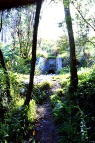
Slide - Photograph, John Ramsdale, Drain into Plenty River: Slide 71, 1990s
... Drain into Plenty River: Slide 71...Photograph shows a culvert or drain with graffiti - long view This drains into the Plenty River....Greensborough Historical Society 34A Glenauburn Road Lower Plenty Lower Plenty melbourne Photograph shows a culvert or drain with graffiti - long view This drains into the Plenty River. ...Photograph shows a culvert or drain with graffiti - long view This drains into the Plenty River.Part of the John Ramsdale collection of slides and audio visual material.Colour photograph scanned from slide.No maker's marks. No caption on slide.plenty river -
 Ringwood and District Historical Society
Photograph, Digging for the big barrel drain which runs down New Street from "Target" to the creek, Ringwood. 1981
... Digging for the big barrel drain which runs down New Street from "Target" to the creek, Ringwood. 1981...Written on back of photograph, '25.8.81 - Digging for the big barrel drain which runs down New Street from "Target" to the creek."...Digging for the big barrel drain which runs down New Street from "Target" to the creek, Ringwood. 1981 Photograph ...Written on back of photograph, '25.8.81 - Digging for the big barrel drain which runs down New Street from "Target" to the creek." -
 Ringwood and District Historical Society
Photograph, The intake to the barrel drain at Pamela Court, North Ringwood in 1976
... The intake to the barrel drain at Pamela Court, North Ringwood in 1976...The entrance to the barrel drain under Kubis Drive before the roads were constructed. ...The intake to the barrel drain at Pamela Court, North Ringwood in 1976 Photograph ...Part of a 101-photo record of the development of the "Bel Air" Estate, Ringwood North, including road works to Debbie Place, Kubis Drive, Jenkins Close, Burlock Avenue, Pamela Court, Manuelo Terrace, Lyn Court, Rudolf Court, Werac Drive, Iluka Place and Glenvale Road. From the Jack Lundy Clarke collection (39 Burlock Avenue, North Ringwood) of photos taken from 1976 to 1982. The developer, Mr Kubis, named streets after his family and associates.The entrance to the barrel drain under Kubis Drive before the roads were constructed. This was opposite, or just up the gully, to Pamela Court in August 1976. -
 Stawell Historical Society Inc
Photograph, Main Drain - Napier Street to Western Highway
... Main Drain - Napier Street to Western Highway...Main Drain - Napier Street to Western Highway...Stawell Historical Society Inc 46 Longfield St Stawell grampians Main Drain - Napier Street to Western Highway Stawell Main Drain - Napier Street to Western Highway Photograph ...Main Drain - Napier Street to Western Highwaystawell -
 Greensborough Historical Society
Slide - Photograph, John Ramsdale, Drain into Plenty River: Slide 8, 1990s
... Drain into Plenty River: Slide 8...Photograph shows a drain or culvert near the Plenty River....Greensborough Historical Society 34A Glenauburn Road Lower Plenty Lower Plenty melbourne Photograph shows a drain or culvert near the Plenty River. Part of the John Ramsdale collection of slides and audio visual material. plenty river drains pollution No maker's marks. ...Photograph shows a drain or culvert near the Plenty River.Part of the John Ramsdale collection of slides and audio visual material.Colour photograph scanned from slide.No maker's marks. No caption on slide.plenty river, drains, pollution -
 Eltham District Historical Society Inc
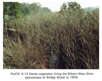
Work on paper (Sub-Item) - Photograph, Dense vegetaton lining the Eltham West Drain downstream of Bridge Street in 1976, 1976
... Dense vegetaton lining the Eltham West Drain downstream of Bridge Street in 1976...Colour photograph of dense vegetation lining the Eltham West drain downstream of Bridge Street, Eltham...Eltham District Historical Society Inc 728 Main Rd Eltham melbourne Colour photograph of dense vegetation lining the Eltham West drain downstream of Bridge Street, Eltham eltham vegetation weeds eltham west drain Image printed on A4 page from 04997 Diamond Creek Basin Study, 1980 Dense vegetaton lining the Eltham West Drain downstream of Bridge Street in 1976 Work on paper Photograph ...Colour photograph of dense vegetation lining the Eltham West drain downstream of Bridge Street, Elthameltham, vegetation, weeds, eltham west drain -
 Eltham District Historical Society Inc
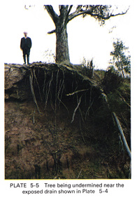
Work on paper (Sub-Item) - Photograph, Tree being undermined near an exposed drain on the west bank of Diamond Creek upstream of Bridge Street, Eltham
... Tree being undermined near an exposed drain on the west bank of Diamond Creek upstream of Bridge Street, Eltham...The tree has been undermined with roots exposed near a council drain....The tree has been undermined with roots exposed near a council drain. eltham diamond creek bridge street drainage roots tree Image printed on A4 page from 04997 Diamond Creek Basin Study, 1980 Tree being undermined near an exposed drain on the west bank of Diamond Creek upstream of Bridge Street, Eltham Work on paper Photograph ...Colour photograph of tree on the side of the Diamond Creek upstream at Bridge Street, Eltham. The tree has been undermined with roots exposed near a council drain.eltham, diamond creek, bridge street, drainage, roots, tree -
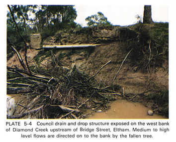 Eltham District Historical Society Inc
Work on paper (Sub-Item) - Photograph, Council drain and drop structure exposed on the west bank of Diamond Creek upstream of Bridge Street, Eltham
... Council drain and drop structure exposed on the west bank of Diamond Creek upstream of Bridge Street, Eltham...Colour photograph of a muddy creek (probably after a downpour) showing council drain and drop structure exposed on the west bank of Diamond Creek upstream of Bridge Street, Eltham. ...Eltham District Historical Society Inc 728 Main Rd Eltham melbourne Colour photograph of a muddy creek (probably after a downpour) showing council drain and drop structure exposed on the west bank of Diamond Creek upstream of Bridge Street, Eltham. ...Colour photograph of a muddy creek (probably after a downpour) showing council drain and drop structure exposed on the west bank of Diamond Creek upstream of Bridge Street, Eltham. Mediun to high level water flows are directed on to the bank by the fallen tree.eltham, creek, diamond creek, bridge street, drainage, waterflow, vegetation -
 Kew Historical Society Inc
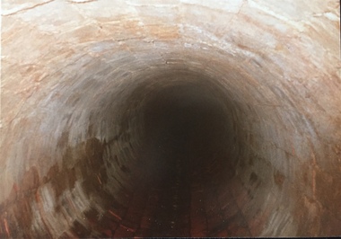
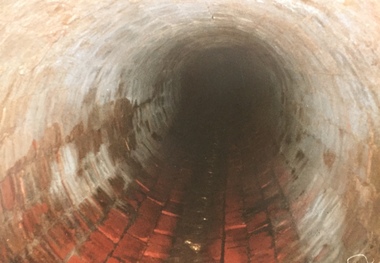
Photograph - Kew Main Drain, 1984
... Three of the drains: Deepdene Drain; Balwyn Drain & Glass Creek converge in Kew East just west of Burke Road at Kew High School before discharging into the Yarra River. ...Original print colour positive photograph of the Kew Main Drain, provided on 14/12.84 to the Chief Engineer of the City of Kew, Ian Poulter, by the Supervising Engineer (Works), Southern and Eastern Drainage, Melbourne & Metropolitan Board of Works. ..."A84/1855-9 / 750mm council drain looking D/S [down stream] and across Parkhill Road. ...Three of the drains: Deepdene Drain; Balwyn Drain & Glass Creek converge in Kew East just west of Burke Road at Kew High School before discharging into the Yarra River. ...'Kew, Kew East, Balwyn & Balwyn North are located approximately 7km north east of Melbourne. Four main stormwater drains service the area flowing from south to north. Three of the drains: Deepdene Drain; Balwyn Drain & Glass Creek converge in Kew East just west of Burke Road at Kew High School before discharging into the Yarra River. The fourth drain, Kew Main Drain connects directly with the Yarra River to the West of Glass Creek.' The Kew Main Drain is a barrel drain that was created in the 1930s, and follows the route of the former Connor's Creek from the vicinity of Genazzano FCJ College to the Yarra River in East KewImportant and verifiable evidence of the construction methods used by the Melbourne & Metropolitan Board of Works in building the Kew Main Drain, before its reconstruction in c.1985.Original print colour positive photograph of the Kew Main Drain, provided on 14/12.84 to the Chief Engineer of the City of Kew, Ian Poulter, by the Supervising Engineer (Works), Southern and Eastern Drainage, Melbourne & Metropolitan Board of Works. The record includes an image of the reverse as well as the donation document from the MMBW."A84/1855-9 / 750mm council drain looking D/S [down stream] and across Parkhill Road. To be replaced with 1200 mm R.C.P. [reinforced concrete pipe] as part of MMBW Kew Main Drain reconstruction works"kew main drain, stormwater drains -- kew (vic.), connor's creek -- kew (vic.) -
 Greensborough Historical Society
Photograph - Digital image, Marilyn Smith et al, Janefield Precinct: Old shed base, outline, spoon drain and post holes, 27/11/2014
... Janefield Precinct: Old shed base, outline, spoon drain and post holes....Janefield Precinct: Old shed base, outline, spoon drain and post holes. The remains of this site are between Greensborough and Janefield. ...Janefield Precinct: Old shed base, outline, spoon drain and post holes. Photograph - Digital image Marilyn Smith Norm Colvin ...Janefield Precinct: Old shed base, outline, spoon drain and post holes. The remains of this site are between Greensborough and Janefield. A RAAF Hygiene Training Camp was located on the Plenty River, just south of the Janefield community. It was in use from 1944 to 1946. The Camp was constructed from salvaged materials. Instruction included building and maintenance of grease traps, latrines, elementary plumbing and carpentry.Early remains of a WW2 training camp 4 Digital colour photographs. -
 Kew Historical Society Inc
Photograph - Kew Main Drain, 1984
... Three of the drains: Deepdene Drain; Balwyn Drain & Glass Creek converge in Kew East just west of Burke Road at Kew High School before discharging into the Yarra River. ...Original print colour positive photograph of the Kew Main Drain, provided on 14/12.84 to the Chief Engineer of the City of Kew, Ian Poulter, by the Supervising Engineer (Works), Southern and Eastern Drainage, Melbourne & Metropolitan Board of Works. ..."A84/1855-10 / 750mm council drain looking U/S [up stream] from Parkhill Road, Kew."...Three of the drains: Deepdene Drain; Balwyn Drain & Glass Creek converge in Kew East just west of Burke Road at Kew High School before discharging into the Yarra River. ...'Kew, Kew East, Balwyn & Balwyn North are located approximately 7km north east of Melbourne. Four main stormwater drains service the area flowing from south to north. Three of the drains: Deepdene Drain; Balwyn Drain & Glass Creek converge in Kew East just west of Burke Road at Kew High School before discharging into the Yarra River. The fourth drain, Kew Main Drain connects directly with the Yarra River to the West of Glass Creek.' The Kew Main Drain is a barrel drain that was created in the 1930s, and follows the route of the former Connor's Creek from the vicinity of Genazzano FCJ College to the Yarra River in East KewImportant and verifiable evidence of the construction methods used by the Melbourne & Metropolitan Board of Works in building the Kew Main Drain, before its reconstruction in c.1985.Original print colour positive photograph of the Kew Main Drain, provided on 14/12.84 to the Chief Engineer of the City of Kew, Ian Poulter, by the Supervising Engineer (Works), Southern and Eastern Drainage, Melbourne & Metropolitan Board of Works. The record includes an image of the reverse as well as the donation document from the MMBW."A84/1855-10 / 750mm council drain looking U/S [up stream] from Parkhill Road, Kew."kew main drain, stormwater drains -- kew (vic.), connor's creek -- kew (vic.) -
 Eltham District Historical Society Inc
Slide, Floodwater, Main drain in Susan Street, Eltham, November 1971, 1971
... Floodwater, Main drain in Susan Street, Eltham, November 1971...Eltham District Historical Society Inc 728 Main Rd Eltham melbourne Eltham, floods, Susan Street 35 mm colour positive transparency Mount - Agfacolor Service (Blue) Floodwater, Main drain in Susan Street, Eltham, November 1971 Slide Slide ...35 mm colour positive transparency Mount - Agfacolor Service (Blue)eltham, floods, susan street -
 Eltham District Historical Society Inc
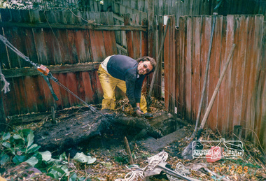
Photograph, Removing tree roots from stormwater drain, Starling Street, Montmorency, 14 December 1989, 14/12/1989
... Removing tree roots from stormwater drain, Starling Street, Montmorency, 14 December 1989...Eltham District Historical Society Inc 728 Main Rd Eltham melbourne Drainage works Eltham Shire Council Maintenance works Montmorency Starling Street Colour photograph Removing tree roots from stormwater drain, Starling Street, Montmorency, 14 December 1989 Photograph ...Colour photographdrainage works, eltham shire council, maintenance works, montmorency, starling street -
 Eltham District Historical Society Inc
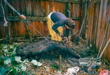
Photograph, Removing tree roots from stormwater drain, Starling Street, Montmorency, 14 December 1989, 14/12/1989
... Removing tree roots from stormwater drain, Starling Street, Montmorency, 14 December 1989...Eltham District Historical Society Inc 728 Main Rd Eltham melbourne drainage works eltham shire council maintenance works montmorency starling street Colour photograph Removing tree roots from stormwater drain, Starling Street, Montmorency, 14 December 1989 Photograph ...Colour photographdrainage works, eltham shire council, maintenance works, montmorency, starling street -
 Eltham District Historical Society Inc
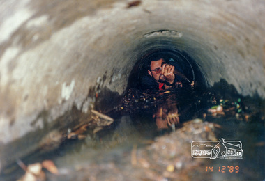
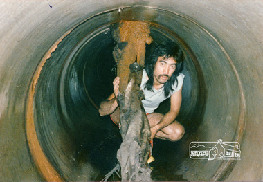
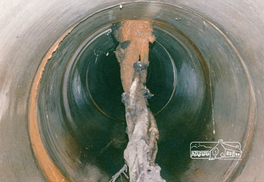
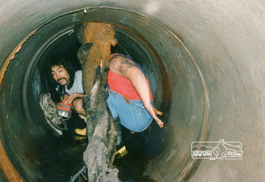
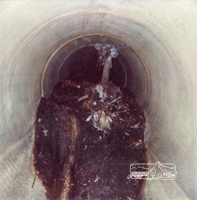
Photograph, Tree roots in main stormwater drain, Eltham Shire Council maintenance works, Lower Plenty, c.1989, 1989c
... Tree roots in main stormwater drain, Eltham Shire Council maintenance works, Lower Plenty, c.1989...Eltham District Historical Society Inc 728 Main Rd Eltham melbourne drainage works eltham shire council Infrastructure Lower Plenty Colour photograph Tree roots in main stormwater drain, Eltham Shire Council maintenance works, Lower Plenty, c.1989 Photograph ...Colour photographdrainage works, eltham shire council, infrastructure, lower plenty -
 Eltham District Historical Society Inc
Photograph, Tree roots in main stormwater drain, Eltham Shire Council maintenance works, Lower Plenty, c.1989, 1989c
... Tree roots in main stormwater drain, Eltham Shire Council maintenance works, Lower Plenty, c.1989...Eltham District Historical Society Inc 728 Main Rd Eltham melbourne drainage works eltham shire council infrastructure lower plenty Colour photograph Tree roots in main stormwater drain, Eltham Shire Council maintenance works, Lower Plenty, c.1989 Photograph ...Colour photographdrainage works, eltham shire council, infrastructure, lower plenty -
 Eltham District Historical Society Inc
Photograph, Tree roots in stormwater drain, Shire of Eltham, c.1980, 1980c
... Tree roots in stormwater drain, Shire of Eltham, c.1980...Eltham District Historical Society Inc 728 Main Rd Eltham melbourne drainage works infrastructure polaroid Polaroid R Manufacturer's Batch No. 06031017011 (June 1980) Colour photograph Tree roots in stormwater drain, Shire of Eltham, c.1980 Photograph ...Colour photographPolaroid R Manufacturer's Batch No. 06031017011 (June 1980)drainage works, infrastructure, polaroid -
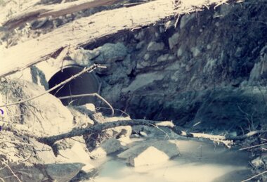
 Eltham District Historical Society Inc
Photograph, Looking east from the northern side of Lower Plenty Road (opposite Bannockburn Road) as it crosses the Watsonia Drain, Viewbank, c.1965, 1965c
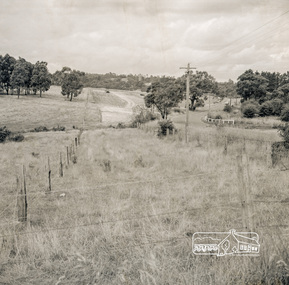
... Looking east from the northern side of Lower Plenty Road (opposite Bannockburn Road) as it crosses the Watsonia Drain, Viewbank, c.1965...Heidelberg Golf Club Lower Plenty Lower Plenty Hotel Road construction Viewbank Watsonia Drain Medium format 120 6x6 black and white negative film, 1 frame Looking east from the northern side of Lower Plenty Road (opposite Bannockburn Road) as it crosses the Watsonia Drain, Viewbank, c.1965 Photograph ...Transmission power lines visible in distance behind the Lower Plenty Hotel (in centre upper) and parts of Heidelberg Golf Club. In the foreground a bulldozer can be seen commencing roadworks for the re-alignment of Lower Plenty Road for the new Lower Plenty Bridge crossing.Medium format 120 6x6 black and white negative film, 1 frameheidelberg golf club, lower plenty, lower plenty hotel, road construction, viewbank, watsonia drain -
 Ringwood and District Historical Society
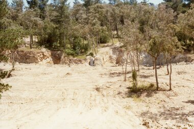
Photograph, The drain tower in Jenkins Close, North Ringwood in 1977 that crossed centre of picture
... The drain tower in Jenkins Close, North Ringwood in 1977 that crossed centre of picture....The developer, Mr Kubis, named streets after his family and associates. The drain tower in Jenkins Close, North Ringwood in 1977 that crossed centre of picture. ...Part of a 101-photo record of the development of the "Bel Air" Estate, Ringwood North, including road works to Debbie Place, Kubis Drive, Jenkins Close, Burlock Avenue, Pamela Court, Manuelo Terrace, Lyn Court, Rudolf Court, Werac Drive, Iluka Place and Glenvale Road. From the Jack Lundy Clarke collection (39 Burlock Avenue, North Ringwood) of photos taken from 1976 to 1982. The developer, Mr Kubis, named streets after his family and associates. The tracks in the foreground are work tracks -
 Ringwood and District Historical Society
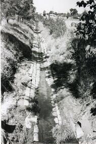
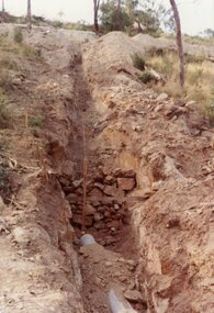
Photograph, Hillside trench to take the the upper level drains to the manhole drain in Kubis Drive, North Ringwood in Feb 1978
... Hillside trench to take the the upper level drains to the manhole drain in Kubis Drive, North Ringwood in Feb 1978...Hillside trench to take the the upper level drains to the manhole drain in Kubis Drive, North Ringwood in Feb 1978 Photograph ...Part of a 101-photo record of the development of the "Bel Air" Estate, Ringwood North, including road works to Debbie Place, Kubis Drive, Jenkins Close, Burlock Avenue, Pamela Court, Manuelo Terrace, Lyn Court, Rudolf Court, Werac Drive, Iluka Place and Glenvale Road. From the Jack Lundy Clarke collection (39 Burlock Avenue, North Ringwood) of photos taken from 1976 to 1982. The developer, Mr Kubis, named streets after his family and associates.