Showing 511 items matching "draining"
-
 University of Melbourne, Burnley Campus Archives
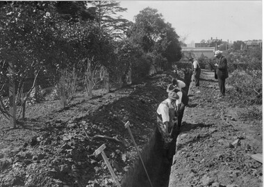
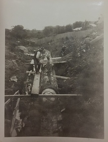
Photograph - Black and white print, Draining Cherry Block Oct 1919, 1919
... Draining Cherry Block Oct 1919......draining...On reverse, "Draining Cherry Block Oct 1919." ...Draining Cherry Block Oct 1919 Photograph Black and white print ...Note by T.H. Kneen 4 December 1991, "The gentleman supervising could be Mr. J.P. McLennan Principal 1916-21."2 copies black and white print. 4 men digging a deep ditch in the Orchard, a child watching and a man supervising.On reverse, "Draining Cherry Block Oct 1919." digging, draining, j.p. mclennan, principal, cherry block, orchard, students working outside -
 Kew Historical Society Inc
Photograph - Kew Main Drain, 1984
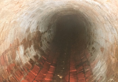
... Three of the drains: Deepdene Drain; Balwyn Drain & Glass Creek converge in Kew East just west of Burke Road at Kew High School before discharging into the Yarra River. ...Original print colour positive photograph of the Kew Main Drain, provided on 14/12.84 to the Chief Engineer of the City of Kew, Ian Poulter, by the Supervising Engineer (Works), Southern and Eastern Drainage, Melbourne & Metropolitan Board of Works. ..."A84/1855-9 / 750mm council drain looking D/S [down stream] and across Parkhill Road. ...Three of the drains: Deepdene Drain; Balwyn Drain & Glass Creek converge in Kew East just west of Burke Road at Kew High School before discharging into the Yarra River. ...'Kew, Kew East, Balwyn & Balwyn North are located approximately 7km north east of Melbourne. Four main stormwater drains service the area flowing from south to north. Three of the drains: Deepdene Drain; Balwyn Drain & Glass Creek converge in Kew East just west of Burke Road at Kew High School before discharging into the Yarra River. The fourth drain, Kew Main Drain connects directly with the Yarra River to the West of Glass Creek.' The Kew Main Drain is a barrel drain that was created in the 1930s, and follows the route of the former Connor's Creek from the vicinity of Genazzano FCJ College to the Yarra River in East KewImportant and verifiable evidence of the construction methods used by the Melbourne & Metropolitan Board of Works in building the Kew Main Drain, before its reconstruction in c.1985.Original print colour positive photograph of the Kew Main Drain, provided on 14/12.84 to the Chief Engineer of the City of Kew, Ian Poulter, by the Supervising Engineer (Works), Southern and Eastern Drainage, Melbourne & Metropolitan Board of Works. The record includes an image of the reverse as well as the donation document from the MMBW."A84/1855-9 / 750mm council drain looking D/S [down stream] and across Parkhill Road. To be replaced with 1200 mm R.C.P. [reinforced concrete pipe] as part of MMBW Kew Main Drain reconstruction works"kew main drain, stormwater drains -- kew (vic.), connor's creek -- kew (vic.) -
 Port Melbourne Historical & Preservation Society
Document - Exhibition Catalogue, Joan Winter, Dredging, Draining, Dipping & Shipping: A History of the Foreshore & Low-lying Lands of the City of Port Phillip, Apr 1996
... Dredging, Draining, Dipping & Shipping: A History of the Foreshore & Low-lying Lands of the City of Port Phillip...Black text and picture of Sandridge from the Esplanade, St Kilda on cover. Dredging, Draining, Dipping & Shipping: A History of the Foreshore & Low-lying Lands of the City of Port Phillip Document Exhibition Catalogue Joan Winter City of Port Phillip ...First major exhibition from the Council of Port Phillip was held in 1995. The catalogue material on Port Melbourne was written by PMH&PS members. It toured the city and then a reduced version was sent to sister city, Devonport. Black text and picture of Sandridge from the Esplanade, St Kilda on cover. sandridge lagoon, engineering - canals and drainage, melbourne harbor trust - port of melbourne authority, piers and wharves, piers and wharves - waterside workers, arts and entertainment, transport - shipping, centenary bridge, beacons, fishermans bend, transport - aviation and aerodrome, sport - swimming, flood, local government - city of port phillip, kulin nation, caroline frederica liardet, swallow & ariell ltd, mission to seafarers, emerald hill, st kilda -
 Vision Australia
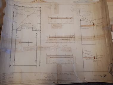
Plan - Image, New verandah & draining to court for the Royal Victorian Institute for Blind, April 1924
... New verandah & draining to court for the Royal Victorian Institute for Blind...100 pounds. royal victorian institute for the blind plans Stephenson & Meldrum, Architects Collins Court 374 Little Collins Street Melbourne Phone: 6990 1 architectural plans for proposed verandah and drainage New verandah & draining to court for the Royal Victorian Institute for Blind Plan Image ...In 1924 plans were submitted to the RVIB board for the addition of a new veranda and associated drainage pipes located in the courtyard behind Ormond Hall. Hand written notes on the plan indicate that the tender for materials from Pollards was 330 pounds, asphalt 35 pounds totally a cost of 365 pounds. And that additional costs of 120 pounds, comprising of 20 for G Lavatory (?) and J Famdy (?) 100 pounds.1 architectural plans for proposed verandah and drainageStephenson & Meldrum, Architects Collins Court 374 Little Collins Street Melbourne Phone: 6990royal victorian institute for the blind, plans -
 Kew Historical Society Inc
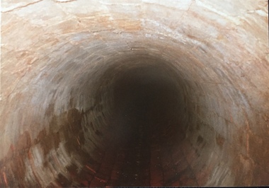
Photograph - Kew Main Drain, 1984
... Three of the drains: Deepdene Drain; Balwyn Drain & Glass Creek converge in Kew East just west of Burke Road at Kew High School before discharging into the Yarra River. ...Original print colour positive photograph of the Kew Main Drain, provided on 14/12.84 to the Chief Engineer of the City of Kew, Ian Poulter, by the Supervising Engineer (Works), Southern and Eastern Drainage, Melbourne & Metropolitan Board of Works. ..."A84/1855-10 / 750mm council drain looking U/S [up stream] from Parkhill Road, Kew."...Three of the drains: Deepdene Drain; Balwyn Drain & Glass Creek converge in Kew East just west of Burke Road at Kew High School before discharging into the Yarra River. ...'Kew, Kew East, Balwyn & Balwyn North are located approximately 7km north east of Melbourne. Four main stormwater drains service the area flowing from south to north. Three of the drains: Deepdene Drain; Balwyn Drain & Glass Creek converge in Kew East just west of Burke Road at Kew High School before discharging into the Yarra River. The fourth drain, Kew Main Drain connects directly with the Yarra River to the West of Glass Creek.' The Kew Main Drain is a barrel drain that was created in the 1930s, and follows the route of the former Connor's Creek from the vicinity of Genazzano FCJ College to the Yarra River in East KewImportant and verifiable evidence of the construction methods used by the Melbourne & Metropolitan Board of Works in building the Kew Main Drain, before its reconstruction in c.1985.Original print colour positive photograph of the Kew Main Drain, provided on 14/12.84 to the Chief Engineer of the City of Kew, Ian Poulter, by the Supervising Engineer (Works), Southern and Eastern Drainage, Melbourne & Metropolitan Board of Works. The record includes an image of the reverse as well as the donation document from the MMBW."A84/1855-10 / 750mm council drain looking U/S [up stream] from Parkhill Road, Kew."kew main drain, stormwater drains -- kew (vic.), connor's creek -- kew (vic.) -
 Kew Historical Society Inc
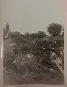
Photograph, City of Kew, City of Kew, Cecil Street Drain, 1936
... City of Kew, Cecil Street Drain...It originated somewhere near the grounds of Genazzano FCJ College. The barrel drain was finally completed in 1941 at a cost of £14,000. ...Inscription on reverse: "City of Kew / Cecil st drain / November 1936". ...City of Kew, Cecil Street Drain Photograph Photograph City of Kew ...An original photograph donated to the Kew Historical Society by the City's Engineering Department following the amalgamation of Kew into the City of Boroondara. While not all of the photographs are of Studley Park, Kew or East Kew, each photo provides a fine snapshot of the work of local government engineering departments of the period. They reveal they types of labour conducted, the techniques used and the equipment and machinery in the possession of the local government authority. Historic and rare photograph of major public works in Kew in the 1930s.Public works. Men at work in the creek bed of Connor's Creek in Kew, while constructing the underground drain. Connor's Creek was one of the two main tributaries of the Yarra River in Kew. It originated somewhere near the grounds of Genazzano FCJ College. The barrel drain was finally completed in 1941 at a cost of £14,000. Inscription on reverse: "City of Kew / Cecil st drain / November 1936". city of kew, city of kew (engineering department), engineering, connor's creek (kew) -
 Kew Historical Society Inc
Photograph, City of Kew, City of Kew, Cecil Street Drain, 1936
... City of Kew, Cecil Street Drain...It originated somewhere near the grounds of Genazzano FCJ College. The barrel drain was finally completed in 1941 at a cost of £14,000. ...Inscription on reverse: "City of Kew / Cecil st drain / November 1936". ...City of Kew, Cecil Street Drain Photograph Photograph City of Kew ...An original photograph donated to the Kew Historical Society by the City's Engineering Department preceding the amalgamation of Kew into the City of Boroondara. While not all of the photographs are of Studley Park, Kew or East Kew, each photo provides a fine snapshot of the work of local government engineering departments of the period. They reveal they types of labour conducted, the techniques used and the equipment and machinery in the possession of the local government authority. Historic and rare photograph of major public works in Kew in the 1930sPublic works. Men at work in the creek bed of Connor's Creek in Kew, while constructing the underground barrel drain. Connors Creek was one of the two main tributaries of the Yarra River in Kew. It originated somewhere near the grounds of Genazzano FCJ College. The barrel drain was finally completed in 1941 at a cost of £14,000. Inscription on reverse: "City of Kew / Cecil st drain / November 1936". public works (kew), roadmaking, engineering, city of kew (engineering department), connor's creek (kew), cecil street drain -
Glenelg Shire Council Cultural Collection
Photograph - Photograph - Portland scene, c. 1970
... Image shows lower north slope Observatory Hill, fence along base, then wooden bridge over Salt Creek that drains into bay, near the Spit Portland....Front: 'Bridge over Portland drain' - green ink...Glenelg Shire Council Cultural Collection History House Cliff Street Portland great-ocean-road Front: 'Bridge over Portland drain' - green ink Photographic print of a rephotographed photograph. ...Photographic print of a rephotographed photograph. Image shows lower north slope Observatory Hill, fence along base, then wooden bridge over Salt Creek that drains into bay, near the Spit Portland.Front: 'Bridge over Portland drain' - green ink -
 Kew Historical Society Inc
Photograph - Construction of the Eastern Freeway (F19), Ron Setford, March 1972
... The photo shows the old river bed of the Yarra and work to alter the Kew Main Drain where it originally entered the river. ..."Eastern Freeway / Old River Bed / Alterations to Kew S/water Drain"...The photo shows the old river bed of the Yarra and work to alter the Kew Main Drain where it originally entered the river. ...Ron Setford and his wife Grace Setford lived in Tanner Avenue, East Kew, from c.1946 to c.1995. A keen photographer, he recorded the changing face of Kew over a 20 year period. Apart from 30 photographs of built structures and places in Kew dating from 1960 and 1961, 145 of his 35mm colour slides chronicle the development of the F19 (later renamed Eastern) Freeway through the Yarra Valley in Kew over a five year period from c.1972 to c.1977. This important collection was donated to the Society by his granddaughter in 2025.This collection of 175 35mm slides is of local and statewide significance, owing to its subject matter, particularly the major development of road transport infrastructure during the 1970s with the construction of the Eastern Freeway. The photographer also took care to annotate and date most of his slides which enable the researcher to pinpoint temporal and spatial locations.Photograph of works involved in construction of the F19 (now Eastern) Freeway. The photo shows the old river bed of the Yarra and work to alter the Kew Main Drain where it originally entered the river. "Eastern Freeway / Old River Bed / Alterations to Kew S/water Drain"ron setford, eastern freeway, f19 freeway -
 Flagstaff Hill Maritime Museum and Village
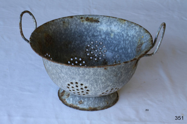
Domestic object - Colander, Late 19th or early 20th Century
... The colander is an extremely useful tool in the kitchen, as it allows food to be fully drained of liquids such as water or oil. Enamelware dates back to 1760 in Germany....Mottled blue enamel colander with draining holes in the base and sides. Two thin handles on lip of bowl....Mottled blue enamel colander with draining holes in the base and sides. Two thin handles on lip of bowl. ...The colander is an extremely useful tool in the kitchen, as it allows food to be fully drained of liquids such as water or oil. Enamelware dates back to 1760 in Germany.This object is significant as an example of a type of item in common use in the 19th Century and that is still in use today.Mottled blue enamel colander with draining holes in the base and sides. Two thin handles on lip of bowl.None.flagstaff hill, warrnambool, shipwrecked-coast, flagstaff-hill, flagstaff-hill-maritime-museum, maritime-museum, shipwreck-coast, flagstaff-hill-maritime-village, enamel, colander, food preparation -
Port Melbourne Historical & Preservation Society
Functional object - Timber planking section, Outfall Timber Drain Reconstruction, c. 1927
... Outfall Timber Drain Reconstruction...This section of timber was cut from a large quantity of the abandoned timber outfall drain during reconstruction by Melbourne Water. ...Section of timber cut from part of the old abandoned timber outfall drain at Esplanade East during reconstruction 2004...Made available to the PMH&PS by Paul Balassone. engineering - canals and drainage melbourne water Section of timber cut from part of the old abandoned timber outfall drain at Esplanade East during reconstruction 2004 Outfall Timber Drain Reconstruction Functional object Timber planking section ...This section of timber was cut from a large quantity of the abandoned timber outfall drain during reconstruction by Melbourne Water. Made available to the PMH&PS by Paul Balassone.Section of timber cut from part of the old abandoned timber outfall drain at Esplanade East during reconstruction 2004engineering - canals and drainage, melbourne water -
 Ballarat Tramway Museum
Slide - 35mm slide/s, Keith Kings, 28/02/1962 12:00:00 AM
... North, 28.2.1962, flushing track drains at Duncan St. loop. Workman in white at rear of tram, parked at entry to loop. ...'K.S.Kings No.' stamped onto slide' 'H(w)(369), 1/250, f11, 28/2/62, Ballarat, Scrubber flushing track drains at loop on Drummond St. Nth.' in blue ink....North, 28.2.1962, flushing track drains at Duncan St. loop. Workman in white at rear of tram, parked at entry to loop. ...Ballarat Scrubber car, in Drummond St. North, 28.2.1962, flushing track drains at Duncan St. loop. Workman in white at rear of tram, parked at entry to loop. Photo by Keith Kings.'K.S.Kings No.' stamped onto slide' 'H(w)(369), 1/250, f11, 28/2/62, Ballarat, Scrubber flushing track drains at loop on Drummond St. Nth.' in blue ink.tramways, trams, ballarat, drummond st. nth, scrubber tram, maintenance, scrubber -
Whitehorse Historical Society Inc.
Article, Water woes, 1993
... Residents in Irene Crescent and Wattle Valley Road will be charged and others will pay for new drains throughout the city....Residents in Irene Crescent and Wattle Valley Road will be charged and others will pay for new drains throughout the city....Residents in Irene Crescent and Wattle Valley Road will be charged and others will pay for new drains throughout the city. Water woes Article Article ...Problems with drainage systems in Nunawading would take 32 years to complete at the rate they were being fixed.Problems with drainage systems in Nunawading would take 32 years to complete at the rate they were being fixed. Residents in Irene Crescent and Wattle Valley Road will be charged and others will pay for new drains throughout the city.Problems with drainage systems in Nunawading would take 32 years to complete at the rate they were being fixed. city of nunawading, ward, kelvin, irene crescent, mitcham, wattle valley road, mitcham, drainage -
Glenelg Shire Council Cultural Collection
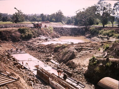
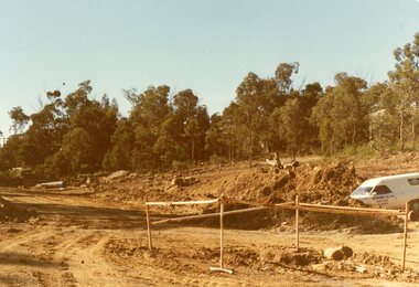
Slide - Slide - Construction Portland/Cashmore Airport, c. 1980
... Oblong shaped concrete drain on left. Workman standing beside mouth of drain. ...Oblong shaped concrete drain on left. Workman standing beside mouth of drain. ... -
 Mont De Lancey
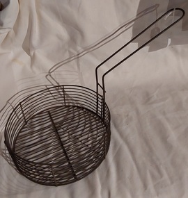
Domestic object - Deep Fryer Basket, 1950's
... Deep fryer baskets are typically made of wire mesh or stainless steel, and they allow for both efficient frying and draining of excess oil from cooked food. ...The basket holds the cut chips or fish and has a long thick curved open wire formed handle which can hang on the side of the saucepan for draining the cooking oil....The basket holds the cut chips or fish and has a long thick curved open wire formed handle which can hang on the side of the saucepan for draining the cooking oil. Domestic object Deep Fryer Basket ...Deep fryer baskets are typically made of wire mesh or stainless steel, and they allow for both efficient frying and draining of excess oil from cooked food. A medium sized vintage wire fish and chip fryer from the 1950's. The basket holds the cut chips or fish and has a long thick curved open wire formed handle which can hang on the side of the saucepan for draining the cooking oil.food preparation, food processing equipment, deep fryer basket, 1940s -
Whitehorse Historical Society Inc.
Document, By-Law No 4 - Shire of Blackburn and Mitcham, 1930
... By-Law No 4, covering: Streets and footways; Waterworks, drains etc; Places of improvement, recreation etc.: Regulation of buildings; Fire prevention; Nuisances etc.; Miscellaneous matters; Regulation of proceedings of Council, officers etc....Shire of Blackburn and Mitcham, By-Law No 4, covering: Streets and footways; Waterworks, drains etc; Places of improvement, recreation etc.: Regulation of buildings; Fire prevention; Nuisances etc.; Miscellaneous matters; Regulation of proceedings of Council, officers etc....Whitehorse Historical Society Inc. 2-10 Deep Creek Road Mitcham melbourne By-Law No 4, covering: Streets and footways; Waterworks, drains etc; Places of improvement, recreation etc.: Regulation of buildings; Fire prevention; Nuisances etc.; Miscellaneous matters; Regulation of proceedings of Council, officers etc. ...Shire of Blackburn and Mitcham, By-LawsShire of Blackburn and Mitcham, By-Law No 4, covering: Streets and footways; Waterworks, drains etc; Places of improvement, recreation etc.: Regulation of buildings; Fire prevention; Nuisances etc.; Miscellaneous matters; Regulation of proceedings of Council, officers etc.Shire of Blackburn and Mitcham, By-Lawslocal government, shire of blackburn and mitcham, by-laws -
Hand Tool Preservation Association of Australia Inc
Corkscrew drain
... corkscrew drain cleaning attachment...Hand Tool Preservation Association of Australia Inc No physical address melbourne This item is part of the Thomas Caine Tool Collection, owned by The National Trust of Australia (Victoria) and curated by the Hand Tools Preservation Association of Australia. corkscrew drain cleaning attachment Corkscrew drain ...This item is part of the Thomas Caine Tool Collection, owned by The National Trust of Australia (Victoria) and curated by the Hand Tools Preservation Association of Australia.corkscrew drain cleaning attachment -
Glenelg Shire Council Cultural Collection
Slide - Slide - Construction Portland/Cashmore Airport, c. 1980
... Two people standing to left of drain full of water. Concrete slab across drain. ...Two people standing to left of drain full of water. Concrete slab across drain. ...Coloured slide. Two people standing to left of drain full of water. Concrete slab across drain. Roller on right. -
Glenelg Shire Council Cultural Collection
Slide - Slide - Construction Portland/Cashmore Airport, c. 1980
... Opening at end of drain visible. Trench has been filled in up both sides of drain, so level. ...Opening at end of drain visible. Trench has been filled in up both sides of drain, so level. ...Coloured slide. Same worksite as 5264, 5265. Opening at end of drain visible. Trench has been filled in up both sides of drain, so level. Some concrete form work at mouth of drain. -
![Wal Ives & Bert [Watson] at the outlet of the Kew Main Drain](/media/collectors/550653872162f11fb04854aa/items/61593ef27608a87f688412b1/item-media/61594a5a7608a87f68848c29/item-fit-380x285.jpg?cb=6) Kew Historical Society Inc
Kew Historical Society IncPhotograph - Wal Ives & Bert [Watson] at the outlet of the Kew Main Drain, c.1900
... Until the 1930s, this was an open creek until a barrel drain - the Kew Main Drain - was constructed. ...To the left of the boys is a barrel drain which at that stage was the outlet for Connor's Creek near the Yarra River. ...Until the 1930s, this was an open creek until a barrel drain - the Kew Main Drain - was constructed. ...Connor's Creek is/was one of two major waterways bisecting Kew, both of which empty into the Yarra River. Connor's Creek originates near the grounds of Genazzano FCJ College, which is one of the highest points in Kew. Until the 1930s, this was an open creek until a barrel drain - the Kew Main Drain - was constructed. As the creek ran through Kew it cut across a number of roads the maintenance of which was a continuing concern for Kew Councillors. In August 1864, the Council called for tenders to erect a stone culvert and embankment over Connor's Creek, on Belford-road. This may be the embankment on which the boys are sitting.Original, small photographic positive on card of two boys, identified by the donor as 'Wal Ives and Bert' [Albert Watson] sitting on bluestone capping above an outlet of Connor's Creek. To the left of the boys is a barrel drain which at that stage was the outlet for Connor's Creek near the Yarra River. The retaining wall is constructed of brick. In ink on photo: "Wal & Bert"connors creek -- kew (vic), wal ives, albert watson, belford road, yarra river -- kew (vic.), creeks -- kew (vic.), drains -- kew (vic.) -
 Ballarat Heritage Services
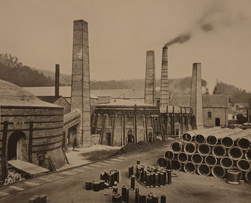
Photograph, Lithgow Brick and Drain-Pipe Works, 1906
... Lithgow Brick and Drain-Pipe Works...Lithgow Brick and Drain-Pipe Works...A brick and pottery works were opened there in 1877 with additional clay also being obtained from deposits near the Mt Clarence Railway Station. lithgow brick and drain-pipe works lithgow Lithgow Brick and Drain-Pipe Works Lithgow Brick and Drain-Pipe Works Photograph ...In 1870 clay deposits were discovered in the Lithgow Valley in the vicinity of the Lithgow Valley Colliery. A brick and pottery works were opened there in 1877 with additional clay also being obtained from deposits near the Mt Clarence Railway Station.Lithgow Brick and Drain-Pipe Workslithgow brick and drain-pipe works, lithgow -
 Ringwood and District Historical Society
Photograph, Earthworks east of the big northwards bend of Kubis Drive, North Ringwood while sewers were being laid in May 1978
... The creek main drain manhole is below the barricade...The creek main drain manhole is below the barricade Part of a 101-photo record of the development of the "Bel Air" Estate, Ringwood North, including road works to Debbie Place, Kubis Drive, Jenkins Close, Burlock Avenue, Pamela Court, Manuelo Terrace, Lyn Court, Rudolf Court, Werac Drive, Iluka Place and Glenvale Road. ...Part of a 101-photo record of the development of the "Bel Air" Estate, Ringwood North, including road works to Debbie Place, Kubis Drive, Jenkins Close, Burlock Avenue, Pamela Court, Manuelo Terrace, Lyn Court, Rudolf Court, Werac Drive, Iluka Place and Glenvale Road. From the Jack Lundy Clarke collection (39 Burlock Avenue, North Ringwood) of photos taken from 1976 to 1982. The developer, Mr Kubis, named streets after his family and associates.The creek main drain manhole is below the barricade -
 Sunshine and District Historical Society Incorporated
Administrative record - City of Sunshine - Commissioner Mr Alexander Alex George Gillon Collection 1976 - 1982 - Reports of the Town Clerk's Department 10th August 1977, City of Sunshine, 10th August 1977
... Station Road Drain Council Officers Reports...City of Sunshine Alexander "Alex" George Gillon Station Road Deer Park Station Road Drain Council Officers Reports Foolscap sized document. ...Station Road Drain Council Officers Reports city of sunshine, alexander "alex" george gillon, station road, deer park -
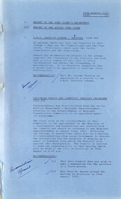
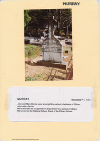 Eltham District Historical Society Inc
Document - Folder, Murray, 2009-2010
... Folder of various items: photographs, photocopies, hand written notes pertaining to John Murray Mary Ellen Drain Mary Murray Thomas drain...Eltham District Historical Society Inc 728 Main Rd Eltham melbourne Initially collated by Harry Gilham as part of a file on Eltham Cemetery eltham cemetery John Murray Mary Ellen Drain Mary Murray Peter Lawlor Thomas drain Folder of various items: photographs, photocopies, hand written notes pertaining to John Murray Mary Ellen Drain Mary Murray Thomas drain Murray Document Folder ...Initially collated by Harry Gilham as part of a file on Eltham Cemeteryeltham cemetery, john murray, mary ellen drain, mary murray, peter lawlor, thomas drain -
Glenelg Shire Council Cultural Collection
Slide - Slide - Cashmore Airport, Portland, 1980s
... Three people standing to left of drain full of water. Concrete slab across drain. ...Three people standing to left of drain full of water. Concrete slab across drain. ...Coloured slide. Three people standing to left of drain full of water. Concrete slab across drain. Roller on right. Cashmore airport construction.portland airport, cashmore, engineering, construction, portland development -
Glenelg Shire Council Cultural Collection
Slide - Slide - Construction Portland/Cashmore Airport, c. 1980
... Rectangular concrete drain running S to N, right of slide. Front end loader carrying a section of drain, on left, grader behind....Rectangular concrete drain running S to N, right of slide. Front end loader carrying a section of drain, on left, grader behind. ...Coloured slide. Rectangular concrete drain running S to N, right of slide. Front end loader carrying a section of drain, on left, grader behind. -
Port Melbourne Historical & Preservation Society
Photograph - Main drain reconstruction, Cruikshank Street, Port Melbourne, Outfall Timber Drain Reconstruction, 23 Aug 2004
... Outfall Timber Drain Reconstruction...Photographs & plans supplied by Melbourne water of Cruikshank Street main drain reconstruction of bay outfall. 2004 .01 19x25 colour photo of clear spanning footing .02 19x25 colour photo of outer edge of drain .03 19x25 colour photo of top deck of drain .04 19x25 colour photo of excavation .05 - .08 19x25 colour photo of excavation of drain .09 - .12 colour photo of excavation of drain .13 - .14 22x33 colour photo of plan of area .15 - .17 39x53 drawn plan of area surrounding .18 - .19 39x53 Cruikshank St main drain reconstruction .20 Initial e-mail letter regarding drain (3-8-04) .21 Business card, Melbourne Water's Paul Balassome...Port Melbourne Historical & Preservation Society Port Melbourne Town Hall 333 Bay Street Port Melbourne melbourne Engineering - Canals and Drainage Cruikshank Street Photographs & plans supplied by Melbourne water of Cruikshank Street main drain reconstruction of bay outfall. 2004 .01 19x25 colour photo of clear spanning footing .02 19x25 colour photo of outer edge of drain .03 19x25 colour photo of top deck of drain .04 19x25 colour photo of excavation .05 - .08 19x25 colour photo of excavation of drain .09 - .12 colour photo of excavation of drain .13 - .14 22x33 colour photo of plan of area .15 - .17 39x53 drawn plan of area surrounding .18 - .19 39x53 Cruikshank St main drain reconstruction .20 Initial e-mail letter regarding drain (3-8-04) .21 Business card, Melbourne Water's Paul Balassome Outfall Timber Drain Reconstruction Photograph Main drain reconstruction, Cruikshank Street, Port Melbourne ...Photographs & plans supplied by Melbourne water of Cruikshank Street main drain reconstruction of bay outfall. 2004 .01 19x25 colour photo of clear spanning footing .02 19x25 colour photo of outer edge of drain .03 19x25 colour photo of top deck of drain .04 19x25 colour photo of excavation .05 - .08 19x25 colour photo of excavation of drain .09 - .12 colour photo of excavation of drain .13 - .14 22x33 colour photo of plan of area .15 - .17 39x53 drawn plan of area surrounding .18 - .19 39x53 Cruikshank St main drain reconstruction .20 Initial e-mail letter regarding drain (3-8-04) .21 Business card, Melbourne Water's Paul Balassomeengineering - canals and drainage, cruikshank street -
 Ringwood and District Historical Society
Photograph, The temporary end of Menzies Drive, North Ringwood in Feb 1978
... The drain down to the manhole in Kubis Drive goes from here...The drain down to the manhole in Kubis Drive goes from here Part of a 101-photo record of the development of the "Bel Air" Estate, Ringwood North, including road works to Debbie Place, Kubis Drive, Jenkins Close, Burlock Avenue, Pamela Court, Manuelo Terrace, Lyn Court, Rudolf Court, Werac Drive, Iluka Place and Glenvale Road. ...Part of a 101-photo record of the development of the "Bel Air" Estate, Ringwood North, including road works to Debbie Place, Kubis Drive, Jenkins Close, Burlock Avenue, Pamela Court, Manuelo Terrace, Lyn Court, Rudolf Court, Werac Drive, Iluka Place and Glenvale Road. From the Jack Lundy Clarke collection (39 Burlock Avenue, North Ringwood) of photos taken from 1976 to 1982. The developer, Mr Kubis, named streets after his family and associates.The drain down to the manhole in Kubis Drive goes from here -
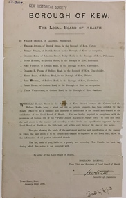 Kew Historical Society Inc
Document, Holland Loxton, Notification to the Residents of Derrick Street by the Local Board of Health, 1885, 1885
... Streets and drains were the basic infrastructure problems for Kew in the 1880s. ...The notice advised the owners that they were required to form and drain the street according to the levels and specifications approved by the Board. ...Decent streets and drains were fundamental to the quality of life of the residents. ...Streets and drains were the basic infrastructure problems for Kew in the 1880s. Decent streets and drains were fundamental to the quality of life of the residents. Without drainage, streets became muddy, boggy and sometimes impassable. Pools and puddles of stagnant water became smelly. The run off water, mixed with human and animal wastes, because there was no sewerage, became a health hazard. Streets and drains then became what were known as 'a nuisance'. Kew suffered from bouts of typhoid fever during the 1880s. Derrick Street was a private street on the margin of the business district of Kew and a well-used thoroughfare. We hear first about Derrick Street when the ratepayers applied to Council to have the street 'taken over' in January 1881. The Council agreed, after much debate, but ratepayers had to pay half the costs. The argument of the majority of the Council was that there was an established policy that ratepayers of private streets either had to hand over the street fully-formed or pay half the costs if Council did the work. It was felt that to make an exception for Derrick Street would create a precedent for ratepayers of other private streets. On the other hand the ratepayers, and a minority of Council, believed that there were extenuating circumstances in the case of Derrick Street. They believed that the costing by the Borough Surveyor was excessive. They felt the Council was partly responsible for the state of the street due to a channel on Bulleen Road, which deposited sand in the street. The Council had also put in some kerbing at the entrance to the street. Finally, the ratepayers believed that the street had become an important and convenient thoroughfare in Kew, and thus should be an exception to the policy on private streets. In the end a decision was delayed to allow the ratepayers to drain and form the street themselves. And there the matter stood till September 1882, when Miss Reilly complained about rubbish on a block of land in Derrick Street. So, in October 1882 the Council agreed to take over and form the street with the ratepayers paying half the costs. The ratepayers did not want to pay, so the argument continued in Council into 1883. There was a standoff for a further 18 months, until the problem could no longer be ignored. In October 1884 the Inspector of Nuisances and the Health Officer reported that Derrick Street was a health hazard as there was no drainage outlet for waste water. These reports changed the status of the problem of Derrick Street. It became an issue of public health, and thus the Council, acting as the Local Board of Health, had power to prepare plans and order the ratepayers to drain the street and pay all the costs, or let the Council do the work and charge ratepayers half the costs of the works. By April 1885, the time for ratepayers to complete the works themselves had expired, so the Council proceeded with the work and required ratepayers to pay for their share of the costs. All ratepayers had paid by the end of April except Mr Whiddycombe, who refused to pay. Mr Whiddycombe was warned to pay in October 1885. Legal action was taken against him in November. The Council lost the case on technical grounds. The Council, acting as the Local Board of Health, relaunched the legal action and won. The last we hear of Derrick Street is that seven day’s notice was given to Derrick Street ratepayers to pay for the drainage works in May 1887. We presume that Mr Whiddycombe paid. (Research: Andrew Frost)Rare and historic publication issued by the Board of Health in the Borough of Kew in 1885 to residents of Derrick street regarding the need for proper drainage for the purpose of improving public health.Printed formal notice sent by the Board of Health of the Borough of Kew to landowners in Derrick Street, Kew. The notice advised the owners that they were required to form and drain the street according to the levels and specifications approved by the Board. The letter was sent on January 23rd 1885, and signed by the Inspector of Nuisances.borough of kew -- greater melbourne (vic.), council notices -- public health, derrick street -- kew (vic.) -
Port Melbourne Historical & Preservation Society
Plan - Drainage Improvements, Ross Street, Port Melbourne, Borough of Port Melbourne, 3 Nov 1892
... Plan of Ross Street drainage improvement diversion drain, 1892....Harrison, Laurence Brady (Contractor) Plan of Ross Street drainage improvement diversion drain, 1892. Plan Drainage Improvements, Ross Street, Port Melbourne Borough of Port Melbourne ...Plan of Ross Street drainage improvement diversion drain, 1892.Signatures of J. J. Bartlett (Mayor), A. V. Heath (Borough Surveyor), W. Harrison, Laurence Brady (Contractor)engineering - canals and drainage, james john bartlett, arthur victor heath, town clerks, w harrison, laurence brady