Showing 25 items matching "eastern golf club"
-
 St Patrick's Old Collegians Association (SPOCA)
Photograph - SPOCA, Annual Dinners
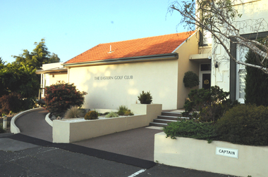
... 2008 The Eastern Golf Club, location of the Annual Dinner for this and several years...St Patrick's Old Collegians Association (SPOCA) Formerly Cnr of Cathedral Place & Lansdowne Street East Melbourne melbourne 2008 The Eastern Golf Club, location of the Annual Dinner for this and several years Photograph SPOCA, Annual Dinners ... -
 Box Hill Historical Society
Book, Editor - Catherine Turnbull, Favourite Escapes to the Outer-East. 100 Years of Holidays. Picnics, Excursions and Sporting Carnivals held in the Outer Eastern Region of Melbourne
... Golf Club...Metropolitan Golf Club...Reilly> J.L. (Mr.)...McCulloch Family...Eastern...Electric Tram Golf Huntingdale Golf Club Metropolitan Golf Club Reilly> J.L. (Mr.) McCulloch Family Eastern Golf Club Maroondah Aquaduct Guest Houses Sport Golf Articles submitted by member societies of the Association of Eastern (regional) Historical societies, covering one hundred years of holidays, picnics, excursions and sporting carnivals held in the Outer Eastern regions of Melbourne, 1865-1960. ...Articles submitted by member societies of the Association of Eastern (regional) Historical societies, covering one hundred years of holidays, picnics, excursions and sporting carnivals held in the Outer Eastern regions of Melbourne, 1865-1960. Note the article on "Empire Day Train Services to Surrey Hills 24 th May, 1907" written by Jack Mclean, a member of Box Hill Historical Society.bailey> william, cole> harry, haywood> charlie, gomm> henry t., head> isabel, head's tea rooms> ferntree gully, lilydale, ferntree gully, yarra flats sabbath school, bell's gulf station, yarra glen, mclean> jack, box hill historical society, surrey hills, hephzibah villa, wilson hill, albert hill, wilson> alfred, wilson> joseph, wilson> caroline (mrs.), smith's gully, hildebrand> mr., hirt> mr., harris> r.j. (mr.), dandenong ranges, herman> - (mr.), trains, duncanson> - (mr.), jones> - (mr.), ward> - (mr.), charman> - (mr.), electric tram, golf, huntingdale golf club, metropolitan golf club, reilly> j.l. (mr.), mcculloch family, eastern golf club, maroondah aquaduct, guest houses, sport, golf -
 Greensborough Historical Society
Article, Journal, Australian Home Beautiful, Lower Plenty State School LP1295, 20/06/1921o
... The Australian Home Beautiful article on the Heidelberg and Eastern Golf Club indicates that its clubhouse comprised two buildings, "Bryn Teg" built by Mrs Thomas, one approximately 1849, the other 40 years later. ...Greensborough Historical Society 34A Glenauburn Road Lower Plenty Lower Plenty melbourne The Australian Home Beautiful article on the Heidelberg and Eastern Golf Club indicates that its clubhouse comprised two buildings, "Bryn Teg" built by Mrs Thomas, one approximately 1849, the other 40 years later. ...The Australian Home Beautiful article on the Heidelberg and Eastern Golf Club indicates that its clubhouse comprised two buildings, "Bryn Teg" built by Mrs Thomas, one approximately 1849, the other 40 years later. The club moved into these buildings about 1928. The stables were converted for use in 1921 by Frederick Henry Gilsenan as the Lower Plenty State School No. 1295 which was open from 20/06/1921 to 11/04/1925. Mr. Gilsenan married Margaret Mar Cornall in 1923. They lived in Heidelberg, had a daughter, Verna in 1924. Mr Gilsenan was transferred to Mt Moriac SS No. 1608 in 1925. The handwritten account is written by Verna.Historical significance about the premises of both the Lower Plenty State School and the Heidelberg Golf Club.4 p. photocopied article from Australian Home Beautiful 1 June 1929, with 2p.handwritten history of the school 20/06/1921-11/04/1925 (2 copies) and page of photographs of building and people.lower plenty primary school, gilsenan, frederick henry, heidelberg golf club -
 Federation University Historical Collection
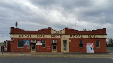
Photograph, Marilyn Jeffs, Hotels of Ballarat, 2019
... eastern railway hotel...freight bar...athletic club hotel...grapes hotel...munster arms hotel...golden city hotel...golf...Barker Library (top floor) Mount Helen goldfields hotels ballarat royal mail hotel peter lalor hotel the george hotel x on albert hotel cattleyards inn market hotel bunch of grapes hotel argyle hotel atlantic hotel ballarat hotel black hill hotel blue bell hotel bluebell hotel brown hill hotel canberra hotel carboni carboni's italian kitchen eureka stockade hotel carriers arms hotel eastern station hotel centenary hotel craig's hotel eastern railway hotel freight bar athletic club hotel grapes hotel munster arms hotel golden city hotel golf house hotel irish murphy's camp hotel lake view hotel la porchetta southern cross hotel the mallow hotel meaghers hotel millers arms miners tavern hotel miner's tavern hotel provincial hotel north britain hotel north star hotel oscar's hotel criterian hotel park hotel prince regent house prince regent hotel sport globe sporting globe jacksons hotel railway hotel pwtn pater lalor hotel royal highlander hotel queen's head hotel red lion hotel robin hood hotel military arms hotel royal oak hotel western hotel imperial hotel unicorn hotel union hotel Numerous photographs take by Marilyn Jeffs for use on the Ballarat and District Industrial Heritage Wiki Hotels of Ballarat Photograph Marilyn Jeffs ...Numerous photographs take by Marilyn Jeffs for use on the Ballarat and District Industrial Heritage Wikihotels, ballarat, royal mail hotel, peter lalor hotel, the george hotel, x on albert hotel, cattleyards inn, market hotel, bunch of grapes hotel, argyle hotel, atlantic hotel, ballarat hotel, black hill hotel, blue bell hotel, bluebell hotel, brown hill hotel, canberra hotel, carboni, carboni's italian kitchen, eureka stockade hotel, carriers arms hotel, eastern station hotel, centenary hotel, craig's hotel, eastern railway hotel, freight bar, athletic club hotel, grapes hotel, munster arms hotel, golden city hotel, golf house hotel, irish murphy's, camp hotel, lake view hotel, la porchetta, southern cross hotel, the mallow hotel, meaghers hotel, millers arms, miners tavern hotel, miner's tavern hotel, provincial hotel, north britain hotel, north star hotel, oscar's hotel, criterian hotel, park hotel, prince regent house, prince regent hotel, sport globe, sporting globe, jacksons hotel, railway hotel, pwtn, pater lalor hotel, royal highlander hotel, queen's head hotel, red lion hotel, robin hood hotel, military arms hotel, royal oak hotel, western hotel, imperial hotel, unicorn hotel, union hotel -
 Greensborough Historical Society
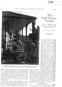
Article - Article, Journal, Kathleen McEwan, The Golf Clubs of Victoria: VI - Heidelberg and Eastern, by Kathleen McEwan, 01/06/ 1929
... Golf Club in 1928, the homestead, Bryn Teg, was built by R. T. Brown about 1849. This article, written in 1929, describes the building and its history in detail. heidelberg golf club bryn teg lower plenty 4 p. black and white photocopy of article from Australian Home Beautiful, June 1, 1929, stapled The Golf Clubs of Victoria: VI - Heidelberg and Eastern, by Kathleen McEwan Article Article, Journal Kathleen McEwan Australian Home Beautiful ...Occupied by the Heidelberg Golf Club in 1928, the homestead, Bryn Teg, was built by R. T. Brown about 1849. This article, written in 1929, describes the building and its history in detail.4 p. black and white photocopy of article from Australian Home Beautiful, June 1, 1929, stapledheidelberg golf club, bryn teg, lower plenty -
 Eltham District Historical Society Inc
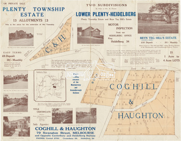
Map (item) - Sales Brochure, Plenty Township Estate and Bryn Teg Hill's Estate, Coghill & Haughton, Melbourne, c.1924
... eastern slope gives the land a grand outlook over the Yarra Valley on to the Dandenoings, and the are is very picturesque and homely." "A number of the blocks contain large deposits of valuable building sand, which should prove good speculation in view of the forecast for further rapid home development along the Eltham Suburban Electric Service." Sand Hills Road (Old Eltham Road) Date estimated as c.1924 - Electricification of railway line to Eltham referenced on map occured April 1923 and Mrs Mary Thomas died August 1925. Her home Bryn Teg became part of the Heidelberg Golf Club...eastern slope gives the land a grand outlook over the Yarra Valley on to the Dandenoings, and the are is very picturesque and homely." "A number of the blocks contain large deposits of valuable building sand, which should prove good speculation in view of the forecast for further rapid home development along the Eltham Suburban Electric Service." Sand Hills Road (Old Eltham Road) Date estimated as c.1924 - Electricification of railway line to Eltham referenced on map occured April 1923 and Mrs Mary Thomas died August 1925. Her home Bryn Teg became part of the Heidelberg Golf Club ...Plenty Township Estate "The rapid growth of Greensborough and the great traffic development on the main road between Heidelberg and Eltham augurs well for Plenty Township Estate. Already a Store, Post Office and State School have been started, and the activities of the Local Progress Association will help the district forward considerably. Within walking distance of the Montmorency and Greensborough stations." Bryn Teg Hill's Estate "Better known as "The Old Sand Hill, "within walking distance of the Montmorency and Greensborough railways stations." "Some few years back Mrs Thomas subdivided portion of the Sand Hill Paddocks, and the areas sold have been settled and many converted into charming outer suburban garden homes with cultivation and orchard plots. The south-eastern slope gives the land a grand outlook over the Yarra Valley on to the Dandenoings, and the are is very picturesque and homely." "A number of the blocks contain large deposits of valuable building sand, which should prove good speculation in view of the forecast for further rapid home development along the Eltham Suburban Electric Service." Sand Hills Road (Old Eltham Road) Date estimated as c.1924 - Electricification of railway line to Eltham referenced on map occured April 1923 and Mrs Mary Thomas died August 1925. Her home Bryn Teg became part of the Heidelberg Golf Club in 1927.The establishment of Lower Plenty as a suburban growth area supported by easy commuting facilitated by the elctrification of the Eltham railway linebonds road, bridge, bryn teg hill's estate, coghill & haughton, eltham road, heidelberg golf club hotel, houses, lower plenty, lower plenty bridge, lower plenty road, main road, plenty hotel, plenty river, plenty township estate, real estate agent, sales brochure, sand hills road, the old sand hill, sand hill paddocks, woodfull road, old eltham road, bryn teg, mrs m thomas -
 Eltham District Historical Society Inc
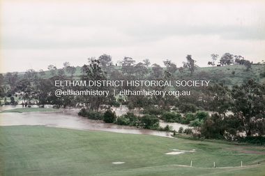
Slide, Floodwater, west from Clubhouse of Rosanna Golf Club, Lower Plenty, November 1971, 1971
... Many parts of Melbourne flooded including Rosanna Golf Club, Lower Plenty in Novembere 1971. Many surburban roads, including the new south-eastern freeway were cut by flood waters. ...Eltham District Historical Society Inc 728 Main Rd Eltham melbourne Many parts of Melbourne flooded including Rosanna Golf Club, Lower Plenty in Novembere 1971. Many surburban roads, including the new south-eastern freeway were cut by flood waters. ...Many parts of Melbourne flooded including Rosanna Golf Club, Lower Plenty in Novembere 1971. Many surburban roads, including the new south-eastern freeway were cut by flood waters. Here the level of the Plenty River floods onto the golf course. 35 mm colour positive transparency Mount - Agfacolor Service (Blue)floods, lower plenty, rosanna golf club, flooding, plenty river -
 Heidelberg Golf Club
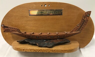
Memorabilia - Trophy, Opotiki Golf Club, Heidelberg Golf Club from Opotiki Golf Club New Zealand, 12/03/1969
... This trophy was presented to HGC by Opotiki Golf Club on 12/03/1969. Opotiki Golf Club is located on the Eastern Bay of Plenty, North Island of New Zealand. ...Heidelberg Golf Club 8 Main Road Lower Plenty 3093 This trophy was presented to HGC by Opotiki Golf Club on 12/03/1969. Opotiki Golf Club is located on the Eastern Bay of Plenty, North Island of New Zealand. ...This trophy was presented to HGC by Opotiki Golf Club on 12/03/1969. Opotiki Golf Club is located on the Eastern Bay of Plenty, North Island of New Zealand. This club celebrated its centenary in 2018. There are no details on why this trophy was given to the Heidelberg Golf Club. If you have any ideas, please contact us.Timber backboard with brass plaque and small Maori boat on shelf.Heidelberg Golf Club from Opotiki Golf Club New Zealandopotiki golf club, heidelberg golf club -
 Kew Historical Society Inc
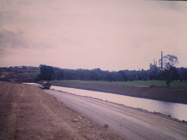
Photograph - Construction of the Eastern Freeway (F19), Ron Setford, November 1972
... Ron Setford Eastern Freeway F19 Freeway "New river course / Latrobe golf club across river / Nov 72" Photograph Construction of the Eastern Freeway (F19) Ron Setford ...Ron Setford and his wife Grace Setford lived in Tanner Avenue, East Kew, from c.1946 to c.1995. A keen photographer, he recorded the changing face of Kew over a 20 year period. Apart from 30 photographs of built structures and places in Kew dating from 1960 and 1961, 145 of his 35mm colour slides chronicle the development of the F19 (later renamed Eastern) Freeway through the Yarra Valley in Kew over a five year period from c.1972 to c.1977. This important collection was donated to the Society by his granddaughter in 2025.This collection of 175 35mm slides is of local and statewide significance, owing to its subject matter, particularly the major development of road transport infrastructure during the 1970s with the construction of the Eastern Freeway. The photographer also took care to annotate and date most of his slides which enable the researcher to pinpoint temporal and spatial locations."New river course / Latrobe golf club across river / Nov 72"ron setford, eastern freeway, f19 freeway -
![Photograph - Construction of the F19 [Eastern Freeway], Ron Setford, January 1973](/media/collectors/550653872162f11fb04854aa/items/67ff96643b378d43a2a88f8b/item-media/67ff96853b378d43a2a890fb/item-fit-380x285.jpg?cb=6) Kew Historical Society Inc
Kew Historical Society IncPhotograph - Construction of the F19 [Eastern Freeway], Ron Setford, January 1973
... Eastern Freeway...F19 Freeway...Buildings -- Kew (Vic) -- Kew Golf Club...Ron Setford Eastern Freeway F19 Freeway Buildings -- Kew (Vic) -- Kew Golf Club "Old Kew Golf Club / Freeway thru window INF F10 125" Photograph Construction of the F19 [Eastern Freeway] Ron Setford ...Ron Setford and his wife Grace Setford lived in Tanner Avenue, East Kew, from c.1946 to c.1995. A keen photographer, he recorded the changing face of Kew over a 20 year period. Apart from 30 photographs of built structures and places in Kew dating from 1960 and 1961, 145 of his 35mm colour slides chronicle the development of the F19 (later renamed Eastern) Freeway through the Yarra Valley in Kew over a five year period from c.1972 to c.1977. This important collection was donated to the Society by his granddaughter in 2025.This collection of 175 35mm slides is of local and statewide significance, owing to its subject matter, particularly the major development of road transport infrastructure during the 1970s with the construction of the Eastern Freeway. The photographer also took care to annotate and date most of his slides which enable the researcher to pinpoint temporal and spatial locations."Old Kew Golf Club / Freeway thru window INF F10 125"ron setford, eastern freeway, f19 freeway, buildings -- kew (vic) -- kew golf club -
![Photograph - Construction of the F19 [Eastern Freeway], Ron Setford, January 1973](/media/collectors/550653872162f11fb04854aa/items/67ff978b3b378d43a2a89613/item-media/67ff97bd3b378d43a2a897a7/item-fit-380x285.jpg?cb=6) Kew Historical Society Inc
Kew Historical Society IncPhotograph - Construction of the F19 [Eastern Freeway], Ron Setford, January 1973
... Eastern Freeway...F19 Freeway...Kew Golf Club...Ron Setford Eastern Freeway F19 Freeway Kew Golf Club "New Kew Golf Club / INF F/7 125 SOC" Photograph Construction of the F19 [Eastern Freeway] Ron Setford ...Ron Setford and his wife Grace Setford lived in Tanner Avenue, East Kew, from c.1946 to c.1995. A keen photographer, he recorded the changing face of Kew over a 20 year period. Apart from 30 photographs of built structures and places in Kew dating from 1960 and 1961, 145 of his 35mm colour slides chronicle the development of the F19 (later renamed Eastern) Freeway through the Yarra Valley in Kew over a five year period from c.1972 to c.1977. This important collection was donated to the Society by his granddaughter in 2025.This collection of 175 35mm slides is of local and statewide significance, owing to its subject matter, particularly the major development of road transport infrastructure during the 1970s with the construction of the Eastern Freeway. The photographer also took care to annotate and date most of his slides which enable the researcher to pinpoint temporal and spatial locations."New Kew Golf Club / INF F/7 125 SOC"ron setford, eastern freeway, f19 freeway, kew golf club -
![Photograph - Construction of the F19 [Eastern Freeway], Ron Setford, May 1976](/media/collectors/550653872162f11fb04854aa/items/6828840164071e7c58e69190/item-media/6828842764071e7c58e693ed/item-fit-380x285.jpg?cb=6) Kew Historical Society Inc
Kew Historical Society IncPhotograph - Construction of the F19 [Eastern Freeway], Ron Setford, May 1976
... Ron Setford Eastern Freeway F19 Freeway "Bank conservation by Kew Golf Club" Photograph Construction of the F19 [Eastern Freeway] Ron Setford ...Ron Setford and his wife Grace Setford lived in Tanner Avenue, East Kew, from c.1946 to c.1995. A keen photographer, he recorded the changing face of Kew over a 20 year period. Apart from 30 photographs of built structures and places in Kew dating from 1960 and 1961, 145 of his 35mm colour slides chronicle the development of the F19 (later renamed Eastern) Freeway through the Yarra Valley in Kew over a five year period from c.1972 to c.1977. This important collection was donated to the Society by his granddaughter in 2025.This collection of 175 35mm slides is of local and statewide significance, owing to its subject matter, particularly the major development of road transport infrastructure during the 1970s with the construction of the Eastern Freeway. The photographer also took care to annotate and date most of his slides which enable the researcher to pinpoint temporal and spatial locations."Bank conservation by Kew Golf Club"ron setford, eastern freeway, f19 freeway -
Kew Historical Society Inc
Booklet - Old Kew Golf Links Estate, 1926
... Golf Club clubhouse, and 'The Moorings' Boathouse (aka Chipperfield's Boat House). The aerial photograph, overlaid with names of notable sites, on the final page is of interest as it shows the area before the intrusion of the Eastern Freeway, which resulted in changing the course of a section of the Yarra River. ...Golf Club clubhouse, and 'The Moorings' Boathouse (aka Chipperfield's Boat House). The aerial photograph, overlaid with names of notable sites, on the final page is of interest as it shows the area before the intrusion of the Eastern Freeway, which resulted in changing the course of a section of the Yarra River. ...Subdivision plans and real estate flyers/brochures reveal a number of aspects of urban development and history. The Kew Historical Society's collection of these plans, as well as advertisements extracted from magazines, cover key aspects of community development and architectural history of Kew and Kew Eat as well as surrounding suburbs. While most of the plans in the collection were gifted to the Society by the former City of Kew, a number of other plans and advertisements have been donated by individuals, of which this is an example.8-page brochure advertising 80 residential home sites for sale in a subdivision called the 'Old Kew Golf Links Estate'. These sites had historic importance in Kew's history as they had previously belonged to Kodak Pty Ltd who were refused permission by Kew Council to use the land for industrial development. The estate, advertised was advertised as being within five miles of Melbourne. The brochure is notable as it includes photographs of Kew East Primary School, the former Kew Golf Club clubhouse, and 'The Moorings' Boathouse (aka Chipperfield's Boat House). The aerial photograph, overlaid with names of notable sites, on the final page is of interest as it shows the area before the intrusion of the Eastern Freeway, which resulted in changing the course of a section of the Yarra River. old kew golf links estate, subdivision -- kew (vic.), subdivisions -- kew east (vic), chipperfield's boathouse, kew east primary school, kew golf club -
Kew Historical Society Inc
Plan - 30 Choice Home Sites in Kilby Road, Meldrum Street and Fairway Drive, 1965
... Original 4-page, bifold brochure, one of two in the collection, of home sites created following the creation of the Eastern Freeway which separated a section of land owned by the Kew Golf Club from the main course. ...Kew Golf Club Original 4-page, bifold brochure, one of two in the collection, of home sites created following the creation of the Eastern Freeway which separated a section of land owned by the Kew Golf Club from the main course. ...Subdivision plans and real estate flyers/brochures reveal a number of aspects of urban development and history. The Kew Historical Society's collection of these plans, as well as advertisements extracted from magazines, cover key aspects of community development and architectural history of Kew and Kew Eat as well as surrounding suburbs. While most of the plans in the collection were gifted to the Society by the former City of Kew, a number of other plans and advertisements have been donated by individuals, of which this is an example.Original 4-page, bifold brochure, one of two in the collection, of home sites created following the creation of the Eastern Freeway which separated a section of land owned by the Kew Golf Club from the main course. The new estate featured 30 lots in Meldrum Street, Kilby Road and Fairway Drive. subdivisions -- kew east (vic.), subdivisions -- kew (vic.), kew golf club -
Kew Historical Society Inc
Plan - 30 Choice Home Sites in Kilby Road, Meldrum Street and Fairway Drive, 1965
... Original 4-page, bifold brochure, one of two in the collection, of home sites created following the creation of the Eastern Freeway which separated a section of land owned by the Kew Golf Club from the main course. ...While most of the plans in the collection were gifted to the Society by the former City of Kew, a number of other plans and advertisements have been donated by individuals, of which this is an example. subdivisions -- kew east (vic.) subdivisions -- kew (vic.) kew golf club Original 4-page, bifold brochure, one of two in the collection, of home sites created following the creation of the Eastern Freeway which separated a section of land owned by the Kew Golf Club from the main course. ...Subdivision plans and real estate flyers/brochures reveal a number of aspects of urban development and history. The Kew Historical Society's collection of these plans, as well as advertisements extracted from magazines, cover key aspects of community development and architectural history of Kew and Kew Eat as well as surrounding suburbs. While most of the plans in the collection were gifted to the Society by the former City of Kew, a number of other plans and advertisements have been donated by individuals, of which this is an example.Original 4-page, bifold brochure, one of two in the collection, of home sites created following the creation of the Eastern Freeway which separated a section of land owned by the Kew Golf Club from the main course. The new estate featured 30 lots in Meldrum Street, Kilby Road and Fairway Drive.subdivisions -- kew east (vic.), subdivisions -- kew (vic.), kew golf club -
 Kew Historical Society Inc
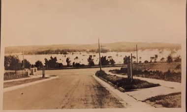
Photograph - Yarra Valley Floods: Kew East, 1916
... Eastern Freeway, much of this low-lying area was used as golf courses and public parks. One of a collection of photographs of flooding in the Kew section of the Yarra Valley which are in important research resource for the location and extent of flooding in the first half of the twentieth century. yarra river yarra valley floods -- kew kilby road -- kew (vic.) kew golf club Verso: "Floods along Kilby Road / near Birdwood St? ...Flooding of the Yarra Valley, including that section of the Yarra bordering Kew and Kew East in the north and west of the municipality, was a regular occurrence. Extreme flood events of the Yarra River are recorded to have occurred in 1891, 1901, 1916, 1923 and 1934. The Municipality of Kew's response to these floods was to enact planning decisions restricting residential development in flood prone areas following the floods of 1916, 1921 and 1934. While floods continued after the development of the Upper Yarra Reservoir (construction 1948-57), the regularity and extent of these inundations diminished. During the nineteenth century, the land abutting the south side of the Yarra in Kew was devoted to dairy farming. In the twentieth century, before and after the construction of the Eastern Freeway, much of this low-lying area was used as golf courses and public parks.One of a collection of photographs of flooding in the Kew section of the Yarra Valley which are in important research resource for the location and extent of flooding in the first half of the twentieth century. Flooding of the Yarra Valley at East Kew in 1916. The view is taken from the intersection of Kilby Road with what is believed to be Birdwood Street, looking across the flood waters to Ivanhoe. The extensive flooded area shown in the photograph would have included the Kew Golf Club. Verso: "Floods along Kilby Road / near Birdwood St? & Kilby Road / 1917? / 87yarra river, yarra valley, floods -- kew, kilby road -- kew (vic.), kew golf club -
 Kew Historical Society Inc
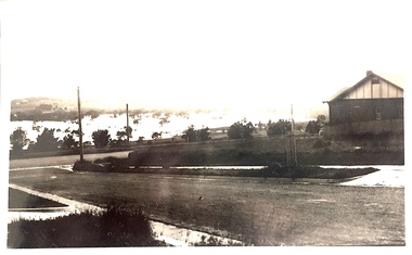
Photograph - Yarra Valley Floods: Kew East, 1916
... Eastern Freeway, much of this low-lying area was used as golf courses and public parks. One of a collection of photographs of flooding in the Kew section of the Yarra Valley which are in important research resource for the location and extent of flooding in the first half of the twentieth century. yarra river yarra valley floods -- kew kilby road -- kew (vic.) kew golf club Verso: "Floods / Yarra River / East Kew / Kilby Road / 1917? ...Flooding of the Yarra Valley, including that section of the Yarra bordering Kew and Kew East in the north and west of the municipality, was a regular occurrence. Extreme flood events of the Yarra River are recorded to have occurred in 1891, 1901, 1916, 1923 and 1934. The Municipality of Kew's response to these floods was to enact planning decisions restricting residential development in flood prone areas following the floods of 1916, 1921 and 1934. While floods continued after the development of the Upper Yarra Reservoir (construction 1948-57), the regularity and extent of these inundations diminished. During the nineteenth century, the land abutting the south side of the Yarra in Kew was devoted to dairy farming. In the twentieth century, before and after the construction of the Eastern Freeway, much of this low-lying area was used as golf courses and public parks.One of a collection of photographs of flooding in the Kew section of the Yarra Valley which are in important research resource for the location and extent of flooding in the first half of the twentieth century. Flooding of the Yarra Valley at East Kew in 1916. The view is taken from a street (maybe Birdwood Avenue) intersecting with Kilby Road looking northeast across the flood waters to Ivanhoe and Heidelberg. The extensive flooded area shown in the photograph would have included remnant dairy farms and the Kew Golf Club. Verso: "Floods / Yarra River / East Kew / Kilby Road / 1917? / 87"yarra river, yarra valley, floods -- kew, kilby road -- kew (vic.), kew golf club -
 Kew Historical Society Inc
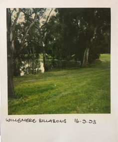
Photograph - Willsmere [Kew] Billabong, 1993
... Willsmere Park is bounded by the the Yarra River, Green Acres Golf Club, Willow Grove and the Eastern Freeway. The land on which the park is now situated was bought by Thomas Wills at the Crown Land Sales of 1846 (Section 56). ...Kew Historical Society Inc Kew Court House 188 High Street Kew melbourne Willsmere Park is bounded by the the Yarra River, Green Acres Golf Club, Willow Grove and the Eastern Freeway. The land on which the park is now situated was bought by Thomas Wills at the Crown Land Sales of 1846 (Section 56). ...Willsmere Park is bounded by the the Yarra River, Green Acres Golf Club, Willow Grove and the Eastern Freeway. The land on which the park is now situated was bought by Thomas Wills at the Crown Land Sales of 1846 (Section 56). From the 1840s to the 1940s it was intensively farmed. The park is dominated by very large playing fields, while planting to the southern boundary was undertaken when the Eastern Freeway was built. It is only along the banks of the Yarra that there is any remnant native vegetation. Willsmere Park is of significance as an area of open land that remains from the flood plain that once dominated northern Kew. (Source: Kew Conservation Study, 1988)Original colour small format polaroid photograph of the 'Kew Billabong' in the Willsmere Park, taken on 16 September 1993."Willsmere Billabong 16.9.93"kew billabong, willsmere park, yarra river -- billabongs -
 Kew Historical Society Inc
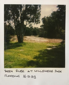
Photograph - Yarra River in flood at the Willsmere Park, 1993
... Willsmere Park is bounded by the the Yarra River, Green Acres Golf Club, Willow Grove and the Eastern Freeway. The land on which the park is now situated was bought by Thomas Wills at the Crown Land Sales of 1846 (Section 56). ...Kew Historical Society Inc Kew Court House 188 High Street Kew melbourne Willsmere Park is bounded by the the Yarra River, Green Acres Golf Club, Willow Grove and the Eastern Freeway. The land on which the park is now situated was bought by Thomas Wills at the Crown Land Sales of 1846 (Section 56). ...Willsmere Park is bounded by the the Yarra River, Green Acres Golf Club, Willow Grove and the Eastern Freeway. The land on which the park is now situated was bought by Thomas Wills at the Crown Land Sales of 1846 (Section 56). From the 1840s to the 1940s it was intensively farmed. The park is dominated by very large playing fields, while planting to the southern boundary was undertaken when the Eastern Freeway was built. It is only along the banks of the Yarra that there is any remnant native vegetation. Willsmere Park is of significance as an area of open land that remains from the flood plain that once dominated northern Kew. (Source: Kew Conservation Study, 1988)Original colour small format polaroid photograph of the Yarra River in flood at the Willsmere Park, taken on 16 September 1993."Yarra River at Willsmere Park Flooding 16.9.93"willsmere park, yarra river -- floods -- kew (vic.) -
 Kew Historical Society Inc
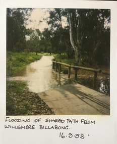
Photograph - Flooding in the Willsmere Park, 1993
... Willsmere Park is bounded by the the Yarra River, Green Acres Golf Club, Willow Grove and the Eastern Freeway. The land on which the park is now situated was bought by Thomas Wills at the Crown Land Sales of 1846 (Section 56). ...Kew Historical Society Inc Kew Court House 188 High Street Kew melbourne Willsmere Park is bounded by the the Yarra River, Green Acres Golf Club, Willow Grove and the Eastern Freeway. The land on which the park is now situated was bought by Thomas Wills at the Crown Land Sales of 1846 (Section 56). ...Willsmere Park is bounded by the the Yarra River, Green Acres Golf Club, Willow Grove and the Eastern Freeway. The land on which the park is now situated was bought by Thomas Wills at the Crown Land Sales of 1846 (Section 56). From the 1840s to the 1940s it was intensively farmed. The park is dominated by very large playing fields, while planting to the southern boundary was undertaken when the Eastern Freeway was built. It is only along the banks of the Yarra that there is any remnant native vegetation. Willsmere Park is of significance as an area of open land that remains from the flood plain that once dominated northern Kew. (Source: Kew Conservation Study, 1988)Original colour small format polaroid photograph of flooding in the Willsmere Park, taken on 16 September 1993."Flooding of shared path from Willsmere Billabong 16.9.93"willsmere park, yarra river -- floods -- kew (vic.), kew billabong -
 Kew Historical Society Inc
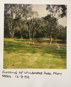
Photograph - Flooding in the Willsmere Park, 1993
... Willsmere Park is bounded by the the Yarra River, Green Acres Golf Club, Willow Grove and the Eastern Freeway. The land on which the park is now situated was bought by Thomas Wills at the Crown Land Sales of 1846 (Section 56). ...Kew Historical Society Inc Kew Court House 188 High Street Kew melbourne Willsmere Park is bounded by the the Yarra River, Green Acres Golf Club, Willow Grove and the Eastern Freeway. The land on which the park is now situated was bought by Thomas Wills at the Crown Land Sales of 1846 (Section 56). ...Willsmere Park is bounded by the the Yarra River, Green Acres Golf Club, Willow Grove and the Eastern Freeway. The land on which the park is now situated was bought by Thomas Wills at the Crown Land Sales of 1846 (Section 56). From the 1840s to the 1940s it was intensively farmed. The park is dominated by very large playing fields, while planting to the southern boundary was undertaken when the Eastern Freeway was built. It is only along the banks of the Yarra that there is any remnant native vegetation. Willsmere Park is of significance as an area of open land that remains from the flood plain that once dominated northern Kew. (Source: Kew Conservation Study, 1988)Original colour small format polaroid photograph of flooding in the Willsmere Park, taken on 16 September 1993."Flooding of Willsmere Park from Yarra 16.9.93"willsmere park, yarra river -- floods -- kew (vic.) -
 Kew Historical Society Inc
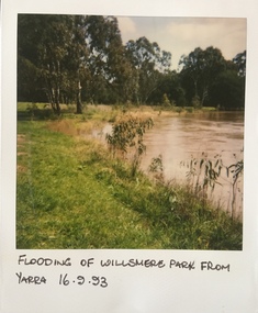
Photograph - Flooding of Willsmere Park from Yarra, 1993
... Willsmere Park is bounded by the the Yarra River, Green Acres Golf Club, Willow Grove and the Eastern Freeway. The land on which the park is now situated was bought by Thomas Wills at the Crown Land Sales of 1846 (Section 56). ...Kew Historical Society Inc Kew Court House 188 High Street Kew melbourne Willsmere Park is bounded by the the Yarra River, Green Acres Golf Club, Willow Grove and the Eastern Freeway. The land on which the park is now situated was bought by Thomas Wills at the Crown Land Sales of 1846 (Section 56). ...Willsmere Park is bounded by the the Yarra River, Green Acres Golf Club, Willow Grove and the Eastern Freeway. The land on which the park is now situated was bought by Thomas Wills at the Crown Land Sales of 1846 (Section 56). From the 1840s to the 1940s it was intensively farmed. The park is dominated by very large playing fields, while planting to the southern boundary was undertaken when the Eastern Freeway was built. It is only along the banks of the Yarra that there is any remnant native vegetation. Willsmere Park is of significance as an area of open land that remains from the flood plain that once dominated northern Kew. (Source: Kew Conservation Study, 1988)Original colour small format polaroid photograph of flooding in Willsmere Park resulting from heavy rain on 15 September 1993."Flooding of Willsmere Park from Yarra 16.9.93"yarra river -- floods -- kew (vic.), willsmere park -
 Kew Historical Society Inc
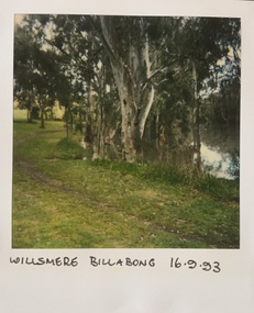
Photograph - Willsmere [Kew] Billabong, 1993
... Willsmere Park is bounded by the the Yarra River, Green Acres Golf Club, Willow Grove and the Eastern Freeway. The land on which the park is now situated was bought by Thomas Wills at the Crown Land Sales of 1846 (Section 56). ...Kew Historical Society Inc Kew Court House 188 High Street Kew melbourne Willsmere Park is bounded by the the Yarra River, Green Acres Golf Club, Willow Grove and the Eastern Freeway. The land on which the park is now situated was bought by Thomas Wills at the Crown Land Sales of 1846 (Section 56). ...Willsmere Park is bounded by the the Yarra River, Green Acres Golf Club, Willow Grove and the Eastern Freeway. The land on which the park is now situated was bought by Thomas Wills at the Crown Land Sales of 1846 (Section 56). From the 1840s to the 1940s it was intensively farmed. The park is dominated by very large playing fields, while planting to the southern boundary was undertaken when the Eastern Freeway was built. It is only along the banks of the Yarra that there is any remnant native vegetation. Willsmere Park is of significance as an area of open land that remains from the flood plain that once dominated northern Kew. (Source: Kew Conservation Study, 1988)Original colour small format polaroid photograph of Willsmere [Kew] Billabong on September 1993."Willsmere Billabong 16.9.93"yarra river -- floods -- kew (vic.), willsmere park -
 Kew Historical Society Inc
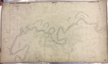
Map, MMBW, MMBW Plan No.117 Heidelberg & Kew, 1900-1910
... The map covers what was then the north eastern part of Kew showing the natural landscape and limited development on the south side of the Yarra River. In the Kew section, south of the river, the land is occupied currently by the Greenacres and Kew Golf Clubs. ...The map covers what was then the north eastern part of Kew showing the natural landscape and limited development on the south side of the Yarra River. In the Kew section, south of the river, the land is occupied currently by the Greenacres and Kew Golf Clubs. ...The Melbourne and Metropolitan Board of Works (MMBW) was established by an act of the Victorian Parliament in 1890 to prepare for and to implement a sewerage and water reticulation system across what was then inner Melbourne, its surrounding and middle distance suburbs, including Kew. The MMBW was disbanded in 1991.The map collection of the Kew Historical Society has at its core the historic maps assembled and originally stored in the City Engineer's Department of the City of Kew. These include maps in a number of scales. The vast majority of maps were produced by the MMBW in the first two decades of the twentieth century, and are solid working maps, backed by linen for durability. These maps are historically significant to Kew, the City of Boroondara and to the history of the development of state utilities in Victoria. A number of the Kew maps have additional details added by former municipal officers, including the levels reached by various floods. As these were working documents, information was added to them long after the period of their initial production and distribution.Early map of part of the Borough of Kew, created in the early twentieth century, at a scale 160 ft to 1 inch. The map covers what was then the north eastern part of Kew showing the natural landscape and limited development on the south side of the Yarra River. In the Kew section, south of the river, the land is occupied currently by the Greenacres and Kew Golf Clubs. The map shows the extent of urban development by that time and the outlines of the few built structures in the municipality. The height above sea level of all parts of the landscape are indicated numerically in feet. Contour lines and the levels of historic floods were added in ink to the map at a later stage. MELBOURNE AND METROPOLITAN BOARD OF WORKS / PLAN NO. 117 / HEIDELBERG & KEW melbourne & metropolitan board of works, mmbw maps, borough of kew, cartography, mmbw plan no. 117, kew (vic.) -- maps, heidelberg (vic.) -- maps -
 Lakes Entrance Historical Society
Photograph - Lakes Entrance Tidy Town Committee c2000, Lakes Entrance Tidy Town Committee
... Greens which shows view across Warm Holes to Golf Club No 1 green adjacent to Eastern Beach...Greens which shows view across Warm Holes to Golf Club No 1 green adjacent to Eastern Beach People Golf Club sand dunes warm holes Colour photograph showing Brian Klemm of Keep Australia Beautiful Council with Margaret Daly and Trish Haberfield of Tidy Town Committee with John Stapleton Robert Blackham Tony McDonough Barry McKenzie and Trevor McCubbin of LE Golf Club inspecting stabilisation work on dunes beside greens Lakes Entrance Victoria Photograph Lakes Entrance Tidy Town Committee c2000 Lakes Entrance Tidy Town Committee ...Greens which shows view across Warm Holes to Golf Club No 1 green adjacent to Eastern BeachColour photograph showing Brian Klemm of Keep Australia Beautiful Council with Margaret Daly and Trish Haberfield of Tidy Town Committee with John Stapleton Robert Blackham Tony McDonough Barry McKenzie and Trevor McCubbin of LE Golf Club inspecting stabilisation work on dunes beside greens Lakes Entrance Victoria people, golf club, sand dunes, warm holes