Showing 26 items matching "economic survey"
-
 Tatura Irrigation & Wartime Camps Museum
Book, The Australian Deciduous Canning Fruitgrowing Industry, 1971
... ...economic survey...An economic survey 1965/66 to 1968/69 of the Australian deciduous canning fruitgrowing industry...Tatura Irrigation & Wartime Camps Museum 49 Hogan Street Tatura the-murray An economic survey 1965/66 to 1968/69 of the Australian deciduous canning fruitgrowing industry canning fruitgrowing decidious fruitgrowing economic survey Cream and blue cover, black writing. ...An economic survey 1965/66 to 1968/69 of the Australian deciduous canning fruitgrowing industryCream and blue cover, black writing.canning, fruitgrowing, decidious fruitgrowing, economic survey -
 Warrnambool and District Historical Society Inc.
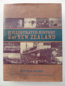
Book, Illustrated history of New Zealand, 2004
... economic reasons. Some residents of Warrnambool and district were involved in the Maori Wars and there was regular shipping between the two places with much timber imported from New Zealand, especially for the McGennan butter box factory and for building purposes (e.g. St. Joseph’s Church). The builder of theWarrnambool Breakwater, Arthur Dudley Dobson, came to Warrnambool after having practised his surveying...economic reasons. Some residents of Warrnambool and district were involved in the Maori Wars and there was regular shipping between the two places with much timber imported from New Zealand, especially for the McGennan butter box factory and for building purposes (e.g. St. Joseph’s Church). The builder of theWarrnambool Breakwater, Arthur Dudley Dobson, came to Warrnambool after having practised his surveying ...This is an illustrated history of New Zealand. Since the foundation of Warrnambool in 1847 up to the present day there has been regular and important contact between the people of Warrnambool and New Zealand. In the 19th and early 20th centuries many people in Warrnambool moved either temporarily or permanently to New Zealand for marriage or economic reasons. Some residents of Warrnambool and district were involved in the Maori Wars and there was regular shipping between the two places with much timber imported from New Zealand, especially for the McGennan butter box factory and for building purposes (e.g. St. Joseph’s Church). The builder of theWarrnambool Breakwater, Arthur Dudley Dobson, came to Warrnambool after having practised his surveying and engineering skills in New Zealand (South Island – Trans Alpine Railway etc). This book is very useful for research into the Warrnambool/New Zealand connection, especially in the 19th century. There is information in this book on Arthur Dudley Dobson who was important in the history of both Warrnambool and New Zealand. This is a hard cover book of 488 pages. The cover is green with gold lettering on the front and spine. There is also a dust cover with a brown and green background with gold and green lettering and sepia-coloured photographs on the front and back covers. The book has illustrations from the Alexander Turnbull Library, an introduction, ten chapters of text, notes, glossary, bibliography and index. new zealand, arthur dudley dobson, history of warrnambool -
 Bendigo Military Museum
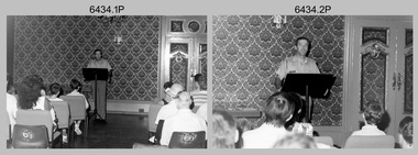
Photograph - Army Survey Regiment Open Day - Briefings and Tours, Fortuna, Bendigo, 1990
... The Royal Australian Survey Corps recognised that an Open Day was the best way for the local community in Bendigo to gain an insight into the unit’s important role as Defence’s map production agency, its technical equipment, and its economic importance to Bendigo. ...The Royal Australian Survey Corps recognised that an Open Day was the best way for the local community in Bendigo to gain an insight into the unit’s important role as Defence’s map production agency, its technical equipment, and its economic importance to Bendigo. ...These 27 photographs were taken at an Army Survey Regiment Open Day at Fortuna Villa, Bendigo on the 24th of February 1990. This occasion was one of several events held to commemorate the 75th anniversary of the formation of the Royal Australian Survey Corps. Although historical tours of Fortuna occurred on a regular basis, this was the first technical open day since 1972. The Royal Australian Survey Corps recognised that an Open Day was the best way for the local community in Bendigo to gain an insight into the unit’s important role as Defence’s map production agency, its technical equipment, and its economic importance to Bendigo. It also gave them an opportunity to tour through historic Fortuna Villa. This occasion is covered in more detail in page 143 of Valerie Lovejoy’s book 'Mapmakers of Fortuna – A history of the Army Survey Regiment’ ISBN: 0-646-42120-4. Refer to items 6435.35P and 6436.18P for more photos of the Open Day taken in the Map Production areas of Air Survey and Cartographic Squadron, and production areas of Lithographic Squadron. Photo prints of some of these photos were scanned and catalogued in items 6247.30P and 6291.6P.These 27 photographs were taken at an Army Survey Regiment Open Day held at Fortuna, Bendigo on the 24th of February 1990. The 35mm colour and black & white negatives photographs were scanned at 96 dpi and are part of the Army Survey Regiment’s Collection. .1) & .2) - Photo, black & white, 1990. Ballroom - Visitor briefings by CO LTCOL Rene van den Tol. .3) - Photo, colour, 1990. Ballroom - Visitor briefings by MAJ Ray Redman. .4) - Photo, colour, 1990. Ballroom - Visitor briefings by unidentified UK Exchange officer. .5) - Photo, black & white, 1990. Music Room - Visitor briefings by MAJ Bob Williams. .6) - Photo, black & white, 1990. Orderly Room - ADJT CAPT Peter Parkes. .7) - Photo, colour, 1990. Music Room - ADJT CAPT Peter Parkes with civilian visitors. .8) - Photo, colour, 1990. Music Room - Visitor briefings by CPL Le-Anne (Smallshaw) Shirley. .9) - Photo, colour, 1990. Entrance Foyer - Visitor briefings. .10) - Photo, colour, 1990. CO’s Office - Visitor briefings by CPL Raelene (Munting) Brodie. .11) - Photo, colour, 1990. Mr Pat Thwaites outlining utilisation of satellite imagery to civilian visitors. .12) - Photo, black & white, 1990. Mr Pat Thwaites outlining utilisation of satellite imagery to civilian visitors. .13) - Photo, colour, 1990. Staircase leading up to the top floor - Visitor briefings by CPL Ian Nelson. .14) - Photo, colour, 1990. Building 16 - Visitor briefings by RSM WO1 Neville Stone. .15) - Photo, colour, 1990. Civilian visitors enjoying views of the garden from Fortuna Villa’s rooftop. .16) - Photo, black & white, 1990. Visitor briefings at Fortuna’s rear steps. .17) - Photo, black & white, 1990. Outside Building 16 - Visitor briefings by WO1 Gary Warnest. .18) - Photo, colour, 1990. Outside Building 16 - Visitor briefings by WO2 Adrian ‘Charlie’ Creedy. .19) - Photo, colour, 1990. Outside Building 16 - L to R: SPR Sue (Foote) Bourne, LCPL Sandy Winn, WO2 Adrian ‘Charlie’ Creedy. .20) - Photo, colour, 1990. Outside Building 16 - SGT Greg Byers. .21) - Photo, colour, 1990. Visitors enjoying Devonshire Tea in the gardens next to the Tavern. .22) - Photo, colour, 1990. RSM WO1 Neville Stone and family enjoying Devonshire Tea in the gardens next to the Tavern. .23) - Photo, colour, 1990. Visitors relaxing in the garden next to Fortuna’s lake. .24) - Photo, black & white, 1990. CPL Trevor Poll and others serve up BBQ lunch next to the tennis courts. .25) to .27) - Photo, colour, 1990. Parking at a premium inside the Army Survey Regiment and Chum Street..1P to .27P – no annotationsroyal australian survey corps, rasvy, army survey regiment, army svy regt, fortuna, asr -
 Bendigo Military Museum
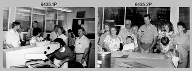
Photograph - Army Survey Regiment Open Day - Map Production, Fortuna, Bendigo, 1990
... The Royal Australian Survey Corps recognised that an Open Day was the best way for the local community in Bendigo to gain an insight into the unit’s important role as Defence’s map production agency, its technical equipment, and its economic importance to Bendigo. ...The Royal Australian Survey Corps recognised that an Open Day was the best way for the local community in Bendigo to gain an insight into the unit’s important role as Defence’s map production agency, its technical equipment, and its economic importance to Bendigo. ...These 35 photographs were taken at an Army Survey Regiment Open Day at Fortuna Villa, Bendigo on the 24th of February 1990. This occasion was one of several events held to commemorate the 75th anniversary of the formation of the Royal Australian Survey Corps. Although historical tours of Fortuna occurred on a regular basis, this was the first technical open day since 1972. The Royal Australian Survey Corps recognised that an Open Day was the best way for the local community in Bendigo to gain an insight into the unit’s important role as Defence’s map production agency, its technical equipment, and its economic importance to Bendigo. It also gave them an opportunity to tour through historic Fortuna Villa. This occasion is covered in more detail in page 143 of Valerie Lovejoy’s book 'Mapmakers of Fortuna – A history of the Army Survey Regiment’ ISBN: 0-646-42120-4. Refer to items 6434.27P and 6436.18P for more photos of the Open Day taken inside Fortuna, the garden areas and production areas of Lithographic Squadron. Photo prints of some of these photos were scanned and catalogued in items 6247.30P and 6291.6P.These 35 photographs were taken at an Army Survey Regiment Open Day held at Fortuna, Bendigo on the 24th of February 1990. The 35mm colour and black & white negatives photographs were scanned at 96 dpi and are part of the Army Survey Regiment’s Collection. .1) - Photo, black & white, 1990. CPL Neale ‘Tex’ Houston with visitors in Aerotriangulation Section. .2) - Photo, black & white, 1990. L to R: MAJ Peter Clark and WO2 Neil ‘Ned’ Kelly with visitors in Aerotriangulation Section. .3) - Photo, black & white, 1990. SGT Bruce Hammond with visitors in Aerotriangulation Section. .4) - Photo, colour, 1990. SGT Bruce Hammond with visitors in Aerotriangulation Section. .5) - Photo, colour, 1990. SGT Steve Gloster with visitors in Aerotriangulation Section. .6) - Photo, colour, 1990. L to R: CPL Noel Brinsmead and CPL Darren Wilkinson with visitors in Aerotriangulation Section. .7) - Photo, colour, 1990. L to R: CPL Noel Brinsmead with visitors in Aerotriangulation Section. .8) - Photo, colour, 1990. MAJ Peter Clark with visitors in Aerotriangulation Section. .9) - Photo, colour, 1990. CPL Mark Lander with visitors in Plotting Section. .10) - Photo, colour, 1990. SSGT Andy Boath with visitors in Plotting Section. .11) - Photo, colour, 1990. SPR Stuart Bowd with visitors in Plotting Section. .12) - Photo, colour, 1990. CAPT Roger Hancock with visitors in Plotting Section. .13) & .14) - Photo, colour, 1990. AUTOMAP 2 - CPL Peter Peterson with visitors. .15) - Photo, colour, 1990, AUTOMAP 2 - L to R: SSGT Graham Johnston, SPR Grant Davis with civilian visitors. .16) - Photo, colour, 1990, AUTOMAP 2 - L to R: CPL Steve McGuiness, SSGT Graham Johnston with civilian visitors. .17) - Photo, colour, 1990, AUTOMAP 2 - civilian visitors. .19) - Photo, colour, 1990, AUTOMAP 2 - L to R: unidentified, SPR Tony Jackson, CPL Mark Westbrook, SSGT Bob Bright, with civilian visitors. .20) - Photo, colour, 1990, AUTOMAP 2 - L to R: WO2 Adrian ‘Charlie’ Creedy, CPL Mark Westbrook, SPR Mick Duggan with civilian visitors. .21) - Photo, colour, 1990, AUTOMAP 2 - L to R: SPR Mick Duggan, CO LTCOM Rene van den Tol, SSGT Bob Bright, CPL Mark Westbrook with civilian visitors. .22) - Photo, colour, 1990, AUTOMAP 2 - L to R: SPR Damien Nolan, unidentified, SPR Peter Smyth with civilian visitors. .23) - Photo, black & white, 1990, AUTOMAP 2 - L to R: SPR Peter Smyth, CAPT Steve Hledik, SGT Martin Evans, MAJ Neil Taylor with civilian visitors. .24) - Photo, black & white, 1990, AUTOMAP 2 - L to R: SPR Mick Duggan, CPL Mark Westbrook with civilian visitors. .25) - Photo, black & white, 1990, AUTOMAP 2 – LCPL Sandy Winn with civilian visitor. .26) - Photo, black & white, 1990. Display of digital storage media. .27) & .28) - Photo, colour, 1990. Cartography - SPR Ian Baldwin with civilian visitors. .29) - Photo, black & white, 1990. Cartography - SPR Ian Baldwin with civilian visitors. .30) - Photo, black & white, 1990. Cartography - SGT Sherri (Dally) Burke with civilian visitors. .31) - Photo, colour, 1990. Cartography - L to R: SGT Sherri (Dally) Burke, SSGT Dennis Learmonth with civilian visitors. .32) - Photo, colour, 1990. Cartography – SGT Barry Hogan with civilian visitors. .33) & .34) - Photo, colour, 1990. Cartography – CPL Dan Cirsky with civilian visitors. .35) - Photo, colour, 1990. Cartography – L to R: SPR Jeanette (Lane) Dury-Lane, CPL Diane (Thomas) Soutar with civilian visitors..1P to .35P – no annotationsroyal australian survey corps, rasvy, army survey regiment, army svy regt, fortuna, asr, automap 2 -
 Bendigo Military Museum
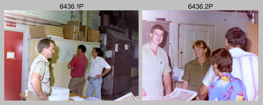
Photograph - Army Survey Regiment Open Day – Lithographic Squadron, Fortuna, Bendigo, 1990
... The Royal Australian Survey Corps recognised that an Open Day was the best way for the local community in Bendigo to gain an insight into the unit’s important role as Defence’s map production agency, its technical equipment, and its economic importance to Bendigo. ...The Royal Australian Survey Corps recognised that an Open Day was the best way for the local community in Bendigo to gain an insight into the unit’s important role as Defence’s map production agency, its technical equipment, and its economic importance to Bendigo. ...These 18 photographs were taken at an Army Survey Regiment Open Day at Fortuna Villa, Bendigo on the 24th of February 1990. This occasion was one of several events held to commemorate the 75th anniversary of the formation of the Royal Australian Survey Corps. Although historical tours of Fortuna occurred on a regular basis, this was the first technical open day since 1972. The Royal Australian Survey Corps recognised that an Open Day was the best way for the local community in Bendigo to gain an insight into the unit’s important role as Defence’s map production agency, its technical equipment, and its economic importance to Bendigo. It also gave them an opportunity to tour through historic Fortuna Villa. This occasion is covered in more detail in page 143 of Valerie Lovejoy’s book 'Mapmakers of Fortuna – A history of the Army Survey Regiment’ ISBN: 0-646-42120-4. Refer to items 6434.27P and 6435.35P for more photos of the Open Day taken inside Fortuna, the garden areas and Map Production areas of Air Survey and Cartographic Squadron. Photo prints of some of these photos were scanned and catalogued in items 6247.30P and 6291.6P.These 18 photographs were taken at an Army Survey Regiment Open Day held at Fortuna, Bendigo on the 24th of February 1990. The 35mm colour and black & white negatives photographs were scanned at 96 dpi and are part of the Army Survey Regiment’s Collection. .1) - Photo, colour, 1990. Print Troop – WO2 Rob Bogumil with visitors. .2) - Photo, colour, 1990. Print Troop – L to R: SPR Ross Anza, LCPL Janet Murray with visitors. .3) - Photo, black & white, 1990. Print Troop – L to R: LCPL Janet Murray, MAJ Bob Coote, SPR Gary Lord with visitors. .4) - Photo, black & white, 1990. Photo Troop – L to R: WO2 Keith Fenton RE UK Exchange, SGT Steve Burke with visitors. .5) - Photo, colour, 1990. Photo Troop – SGT Steve Burke with visitors. .6) - Photo, colour, 1990. Photo Troop – L to R: unidentified, SGT Steve Burke with visitors. .7) - Photo, colour, 1990. Print Troop – L to R: CPL Peter Breukel, WO2 Keith Fenton RE. UK Exchange with visitors. .8) - Photo, black & white, 1990. Photo Troop - WO2 Keith Fenton RE. UK Exchange. .9) - Photo, black & white, 1990. Print Troop - civilian visitors. .10) - black & white, Print Troop, 1990. - L to R: civilian visitors, SSGT Ian Nichols, CPL John ‘Flash’ Anderson. .11) - Photo, black & white, 1990. Print Troop - L to R: SSGT Ian Nichols, CPL Dale Hudson, Planeta printing press, with civilian visitors. .12) - Photo, colour, 1990. Print Troop - L to R: SSGT Ian Nichols, CAPT Roger Hancock with civilian visitors. .13) - Photo, colour, 1990. Print Troop - LT Marty Lyons with civilian visitors. .14) - Photo, black & white, 1990. Print Troop - L to R: LT Marty Lyons, unidentified with civilian visitors. .15) - Photo, black & white, 1990. Orthophoto Mapping Section - L to R: SSGT Peter Imeson, SGT Bob Garritty with civilian visitors. .16) - Photo, colour, 1990. Optronics raster scanner - WO2 Adrian ‘Charlie’ Creedy with civilian visitors. .17) - Photo, colour 1990. Outside Photo Troop office - L to R: SSGT Rhys De Laine, WO2 Rob Bogumil. .18) - Photo, black & white, 1990. Photo Troop - civilian visitors..1P to .18P – no annotationsroyal australian survey corps, rasvy, army survey regiment, army svy regt, fortuna, asr, litho sqn -
 Bendigo Military Museum
Photograph - Speedmaster Printing Press Media Announcement and Army Survey Regiment Open Day, Fortuna Villa, Bendigo, 1990
... The Royal Australian Survey Corps recognised that an Open Day was the best way for the local community in Bendigo to gain an insight into the unit’s important role as Defence’s map production agency, its technical equipment, and its economic importance to Bendigo. ...The Royal Australian Survey Corps recognised that an Open Day was the best way for the local community in Bendigo to gain an insight into the unit’s important role as Defence’s map production agency, its technical equipment, and its economic importance to Bendigo. ...The first photograph was probably taken at a media event announcing the introduction of the Heidelberg Speedmaster printing press in late 1990. LTCOL Rene van den Tol was the CO of the Army Survey Regiment from 1989 to 1991. Partly obscured behind the CO was Mr Bruce Reid, who was the newly elected federal member for Bendigo. The media event was held in Wayzgoose Hall, Lithographic Squadron’s new purpose-built building constructed to house the Speedmaster 102 printing press. The remaining 29 photographs were taken at an Army Survey Regiment Open Day at Fortuna Villa, Bendigo on the 24th of February 1990. This occasion was one of several events held to commemorate the 75th anniversary of the formation of the Royal Australian Survey Corps. Although historical tours of Fortuna occurred on a regular basis, this was the first technical open day since 1972. The Royal Australian Survey Corps recognised that an Open Day was the best way for the local community in Bendigo to gain an insight into the unit’s important role as Defence’s map production agency, its technical equipment, and its economic importance to Bendigo. It also gave them an opportunity to tour through historic Fortuna Villa. This occasion is covered in more detail in page 143 of Valerie Lovejoy’s book 'Mapmakers of Fortuna – A history of the Army Survey Regiment’ ISBN: 0-646-42120-4. Refer to Item 6291.6P for more photos of the Open Day.The first photograph was probably taken at a media event announcing the introduction of the Speedmaster printing press at Army Survey Regiment Fortuna Villa, Bendigo in late 1990. The remaining 29 photographs were taken at an Open Day on the 24th of February 1990. The colour and black & white photographs were printed on photographic paper and are part of the Army Survey Regiment’s Collection. The photographs were scanned at 300 dpi. Photo .19P is also on 35mm negative film and scanned at 2400 dpi. .1) - Photo, colour, 1990. L to R: Unidentified civilian visitor/media, SSGT Ian Nichols, unidentified (x2), SGT Dale Hudson (white top), unidentified (x2), MAJ John South, MHR Mr. Bruce Reid, CO LTCOL Rene van den Tol. .2) - Photo, black & white, 1990. WO1 Gary Warnest, civilian visitors. .3) to .4) - Photo, colour, 1990. WO2 Adrian 'Charlie' Creedy, civilian visitors. .5) - Photo, colour, 1990. Civilian visitors. .6) to .7) - Photo, colour, 1990. Civilian visitors, CPL Peter Peterson. .8) - Photo, black & white, 1990. L to R: LCPL Sandy Winn, civilian visitor. .9) - Photo, colour, 1990. L to R: CPL Steve McGuiness, civilian visitors. .10) - Photo, black & white, 1990. Display of digital storage media. .11) - Photo, colour, 1990. L to R: Mr Pat Thwaites outlining utilisation of satellite imagery to civilian visitors. .12) - Photo, colour, 1990. MAJ Peter Clarke with civilian visitors. .13) - Photo, colour, 1990. Unidentified technician with civilian visitors. .14) - Photo, colour, 1990. SGT Barry Hogan with civilian visitors. .15) - Photo, colour, 1990. SPR Ian Baldwin with civilian visitors. .16) - Photo, black & white, 1990. SPR Ian Baldwin with civilian visitors. .17) - Photo, black & white, 1990. SGT Sherri (Dally) Burke with civilian visitors. .18) - Photo, colour, 1990. L to R: SPR Jeanette (Lane) Dury-Lane, CPL Diane (Thomas) Soutar with civilian visitors. .19) - Photo, colour, 1990. L to R: unidentified technician, CPL Col McInnes, LCPL Charmian McKean. .20) - Photo, black & white, 1990. CAPT Peter Parkes. .21) - Photo, black & white, 1990. L to R: LCPL Janet Murray, MAJ Bob Coote, SPR Gary Lord. .22) - Photo, black & white, 1990. LT Marty Lyons with civilian visitors. .23) - Photo, colour, 1990. LT Marty Lyons with civilian visitors. .24) - Photo, black & white, 1990. SSGT Ian Nichols, CPL Dale Hudson, Planeta printing press, with civilian visitors. .25) - Photo, colour, 1990. Cars parked in Chum Street outside entrance to Fortuna Villa. .26) - Photo, colour, 1990. Civilian visitors near Fortuna Villa’s front door viewed from back gate. .27) - Photo, colour, 1990. Civilian visitors enjoying views of the garden from Fortuna Villa’s rooftop. .28) - Photo, colour, 1990. Civilian visitors enjoying views of the garden from Fortuna Villa’s verandah and rooftop. .29) - Photo, colour, 1990. Civilian visitors enjoying BBQ cooked by CPL Paul Baker and SPR Shona Hastie outside Lithographic Squadron. .30) - Photo, colour, 1990. BBQ cooked by CPL Paul Baker outside Lithographic Squadron..1P to .30P – no annotationsroyal australian survey corps, rasvy, army survey regiment, army svy regt, fortuna, asr, printing, litho -
 Bendigo Military Museum
Administrative record - International Map of the World (IMW) 1:1 Million Scale - H Ureta, Circa 1964, MR H Ereta, Post 1964
... Ereta, Chief of the Cartographic Section of the United Nations Department of Economic Development and Social Affairs gave a lecture on the IMW and described the history and development of the map series in post 1964. This document is a copy of that lecture. Royal Australian Survey ...This document records the history of the International Map of the World (IMW) at 1:1Million Scale. Mr H. Ereta, Chief of the Cartographic Section of the United Nations Department of Economic Development and Social Affairs gave a lecture on the IMW and described the history and development of the map series in post 1964. This document is a copy of that lecture. 7 x Foolscap pages of typed text, stapled and two hole punched, Paper is dis-coloured.royal australian survey corps, rasvy, fortuna, army survey regiment, army svy regt, asr, imw -
 Kiewa Valley Historical Society
Document - Four Geological reports on the North-east Goldfields, Geological Survey of Victoria 1958 Bulletin
... Surveys of N.E. Goldfields Victoria included mines and tunnels. A resurvey of goldfields was necessary to re-assess economic possibilities using modern techniques and structural interpretation. ...Surveys of N.E. Goldfields Victoria included mines and tunnels. A resurvey of goldfields was necessary to re-assess economic possibilities using modern techniques and structural interpretation. ...Geological Surveys of N.E. Goldfields Victoria included mines and tunnels. A resurvey of goldfields was necessary to re-assess economic possibilities using modern techniques and structural interpretation. It included an examination of a considerable surface area with maps and underground workings. Results were correlated and integrated and published by the Mines Department.The mines are in the Bogong Alpine Area.Foolscap printed Victorian Bulletins. Each stapled in the top left corner and each with varying number of pages. Covering 1941-1958 a) Glen Wills and Sunnyside b) Sunnyside Tunnel c) Red Robin d) Maud and Yellow Girl Government Printer, Mines Department, Melbourne, Victoriageology in the north-east, gold fields, goldmines, glen wills -
 Bendigo Military Museum
Photograph - Army Survey Regiment Open Day at Fortuna, Bendigo, 1990
... The Royal Australian Survey Corps recognised that an Open Day was the best way for the local community in Bendigo to gain an insight into the unit’s important role as Defence’s map production agency, its technical equipment, and its economic importance to Bendigo. ...The Royal Australian Survey Corps recognised that an Open Day was the best way for the local community in Bendigo to gain an insight into the unit’s important role as Defence’s map production agency, its technical equipment, and its economic importance to Bendigo. ...These six photographs were taken at an Army Survey Regiment Open Day at Fortuna Villa, Bendigo on the 24th of February 1990. This occasion was one of several events held to commemorate the 75th anniversary of the formation of the Royal Australian Survey Corps. Although historical tours of Fortuna occurred on a regular basis, this was the first technical open day since 1972. The Royal Australian Survey Corps recognised that an Open Day was the best way for the local community in Bendigo to gain an insight into the unit’s important role as Defence’s map production agency, its technical equipment, and its economic importance to Bendigo. It also gave them an opportunity to tour through historic Fortuna Villa. This occasion is covered in more detail in page 143 of Valerie Lovejoy’s book 'Mapmakers of Fortuna – A history of the Army Survey Regiment’ ISBN: 0-646-42120-4. Refer to Item 6247.30P for more photos of the Open Day. These six photographs were taken at an Army Survey Regiment Open Day at Fortuna, Bendigo on the 24th of February 1990. The colour and black & white photographs were printed on photographic paper and are part of the Army Survey Regiment’s Collection. The photographs were scanned at 300 dpi. .1) - Photo, colour, 1990, AUTOMAP 2 L to R: SSGT Graham Johnston, SPR Grant Davis, civilian visitors. .2) - Photo, black & white, 1990. Photo Troop, WO2 Keith Fenton RE. UK Exchange. .3) - Photo, black & white, 1990. Aerotrig, SGT Bruce Hammond, civilian visitors. .4) - Photo, black & white, 1990. AUTOMAP 2 L to R: SPR Peter Smyth, LT Steve Hledik, SGT Martin Evans, MAJ Neil Taylor, Civilian visitors. .5) - black & white, Orthophoto Mapping, L to R: civilian visitors, SSGT Peter Imeson, civilian visitor, SGT Bob Garritty. .6) - black & white, Print Troop L to R: civilian visitors, SSGT Ian Nichols, CPL John ‘Flash’ Anderson..1P to .6P – there are no annotations.royal australian survey corps, army svy regt, rasvy, army survey regiment, fortuna, asr -
 Bendigo Military Museum
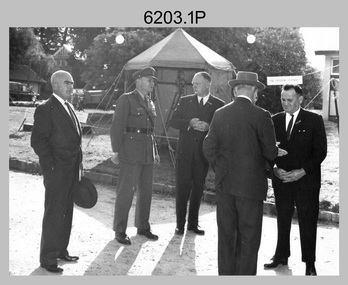
Photograph - Prime Minister’s Visit to the Army Survey Regiment, Fortuna, Bendigo, 1990
... Survey Corps. The one-hour visit was a rare opportunity for RA Svy to demonstrate to its Prime Minister the unit’s important role as Defence’s map production agency, its technical equipment, and its economic importance to Bendigo. ...Survey Corps. The one-hour visit was a rare opportunity for RA Svy to demonstrate to its Prime Minister the unit’s important role as Defence’s map production agency, its technical equipment, and its economic importance to Bendigo. ...These photographs of Prime Minister Hon RJ Hawke’s visit to the Army Survey Regiment were taken at Fortuna, Bendigo in March 1990. This occasion was one of several events held to commemorate the 75th anniversary of the formation of the Royal Australian Survey Corps. The one-hour visit was a rare opportunity for RA Svy to demonstrate to its Prime Minister the unit’s important role as Defence’s map production agency, its technical equipment, and its economic importance to Bendigo. It was also an opportunity to take him through historic Fortuna Villa. This occasion is covered in more detail in page 143 of Valerie Lovejoy’s book 'Mapmakers of Fortuna – A history of the Army Survey Regiment’ ISBN: 0-646-42120-4. Refer to Item 6247.30P for more photos of the Open Day. This set of 34 photographs of Prime Minister Hon RJ Hawke’s visit to the Army Survey Regiment was taken at Fortuna, Bendigo in March 1990. The colour photographs were printed on photographic paper and are part of the Army Survey Regiment’s Collection. The photographs were scanned at 300 dpi. Film negatives are not scanned. .1) - Photo, colour, 1990, L to R: Prime Minister Hon. R.J. Hawke AC GCL greeted by the CO LTCOL Rene van den Tol and the press. In foreground L to R: John Brumby AO, 2IC MAJ Duncan Burns facing away. .2) & .3) - Photo, colour, 1990, Prime Minister Hon. R.J. Hawke AC GCL entering the front steps of Fortuna Villa. L to R: ADJT CAPT Peter Parkes, 2IC MAJ Duncan Burns, Bob Hawke, John Brumby AO (partially obscured), CO LTCOL Rene van den Tol. .4) - Photo, colour, 1990, Prime Minister Hon. R.J. Hawke AC GCL signs the Visitors’ Book in Fortuna Villa’s foyer. L to R: John Brumby AO CO LTCOL Rene van den Tol. .5) - Photo, colour, 1990, The tour of the Army Survey Regiment begins on the rear balcony. L to R: CO LTCOL Rene van den Tol, Prime Minister Hon. R.J. Hawke AC GCL, John Brumby AO, 2IC MAJ Duncan Burns, unidentified. .6) - Photo, colour, 1990, central corridor L to R: 2IC MAJ Duncan Burns, Prime Minister Hon. R.J. Hawke AC GCL, John Brumby AO, CO LTCOL Rene van den Tol. .7) & .8) - Photo, colour, 1990, top of the rear balcony steps L to R: John Brumby AO, Prime Minister Hon. R.J. Hawke AC GCL, CO LTCOL Rene van den Tol, unidentified .9) - Photo, colour, 1990, OC MAJ Peter Clark greets the Prime Minister Hon. R.J. Hawke AC GCL outside Air Survey Squadron. .10) - Photo, colour, 1990, L to R: OC MAJ Neil Taylor and SSM WO1 Graham Ragless greet the Prime Minister Hon. R.J. Hawke AC GCL inside Cartographic Squadron. CO LTCOL Rene van den Tol and John Brumby AO at right. .11) - Photo, colour, 1990, tour of Cartographic Squadron begins L to R: John Brumby AO, CO LTCOL Rene van den Tol, Prime Minister Hon. R.J. Hawke AC GCL OC MAJ Neil Taylor. .12) - Photo, colour, 1990, tour of Cartographic Squadron L to R: SSM WO1 Graham Ragless, OC MAJ Neil Taylor, Prime Minister Hon. R.J. Hawke AC GCL. .13) - Photo, colour, 1990, Cartographic Squadron’s Automap 2 system L to R: 2IC MAJ Duncan Burns, John Brumby AO, CO LTCOL Rene van den Tol, Prime Minister Hon. R.J. Hawke AC GCL, OC MAJ Neil Taylor. .14) - Photo, colour, 1990, Cartographic Squadron’s Automap 2 system L to R: 2IC MAJ Duncan Burns, John Brumby AO, CO LTCOL Rene van den Tol, Prime Minister Hon. R.J. Hawke AC GCL, OC MAJ Neil Taylor, ADJT CAPT Peter Parkes. .15) - Photo, colour, 1990, Cartographic Squadron’s Automap 2 system L to R: OC MAJ Neil Taylor, Prime Minister Hon. R.J. Hawke AC GCL, CO LTCOL Rene van den Tol, John Brumby AO, SPR Stewart Adrain. .16) - Photo, colour, 1990, Cartographic Squadron’s Automap 2 system L to R: ADJT CAPT Peter Parkes, unidentified, John Brumby AO, Prime Minister Hon. R.J. Hawke AC GCL, OC MAJ Neil Taylor, SPR Grant Davis, SSGT Graham Johnson. .17) - Photo, colour, 1990, Cartographic Squadron’s Automap 2 system L to R: SSM WO1 Graham Ragless, OC MAJ Neil Taylor, Prime Minister Hon. R.J. Hawke AC GCL, unidentified, CO LTCOL Rene van den Tol, SSGT Graham Johnson. .18) - Photo, colour, 1990, Cartographic Squadron’s Automap 2 system L to R: OC MAJ Neil Taylor, Prime Minister Hon. R.J. Hawke AC GCL, CO LTCOL Rene van den Tol, ADJT CAPT Peter Parkes. In foreground L to R: CPL Andy Lucas, SPR Geofrey Steegstra, SPR Gordon Santo, SSGT Graham Johnson. .19) - Photo, colour, 1990, Cartographic Squadron’s Automap 2 system L to R: SSM WO1 Graham Ragless, 2IC MAJ Duncan Burns, John Brumby AO, Prime Minister Hon. R.J. Hawke AC GCL, OC MAJ Neil Taylor. .20) - Photo, colour, 1990, Tour group enroute to Lithographc Squadron L to R: John Brumby AO, ADJT CAPT Peter Parkes, Prime Minister Hon. R.J. Hawke AC GCL, unidentified (x2), 2IC MAJ Duncan Burns, CO LTCOL Rene van den Tol. .21) - Photo, colour, 1990, Tour group enters Fortuna’s Stables/Gym. L to R: WO2 George Graham and WO1 Steve Hansen attempt to impress the Prime Minister Hon. R.J. Hawke AC GCL with their sit-ups. .22) - Photo, colour, 1990, Inside Fortuna’s Stables/Gym. L to R: John Brumby AO, Prime Minister Hon. R.J. Hawke AC GCL, CO LTCOL Rene van den Tol, WO2 George Graham, WO1 Steve Hansen perform one more sit-up. .23) - Photo, colour, 1990, L to R: Lithographc Squadron OC MAJ Bob Coote and SSM WO2 Rob Bogumil greet Prime Minister Hon. R.J. Hawke AC GCL. .24) - Photo, colour, 1990, Lithographc Squadron tour begins L to R: John Brumby AO, Prime Minister Hon. R.J. Hawke AC GCL, CO LTCOL Rene van den Tol, 2IC MAJ Duncan Burns, OC MAJ Bob Coote and SSM WO2 Rob Bogumil. .25) - Photo, colour, 1990, Photo Troop tour, L to R: WO2 Bill Jones briefs the Prime Minister Hon. R.J. Hawke AC GCL, CO LTCOL Rene van den Tol, John Brumby AO. .26) - Photo, colour, 1990, Photo Troop, L to R: SSM WO2 Rob Bogumil, WO2 Bill Jones briefs the Prime Minister Hon. R.J. Hawke AC GCL, OC MAJ Bob Coote, John Brumby AO, SPR Darren ‘Barney’ Maher, 2IC MAJ Duncan Burns. .27) - Photo, colour, 1990, Photo Troop tour, L to R: SPR Greg Howell, SPR Andrew Morrison-Evans greet the Prime Minister Hon. R.J. Hawke AC GCL. In background L to R: John Brumby AO, OC MAJ Bob Coote. .28) - Photo, colour, 1990, Photo Troop tour, L to R: SPR Greg Howell, SPR Andrew Morrison-Evans brief the Prime Minister Hon. R.J. Hawke AC GCL, John Brumby AO, OC MAJ Bob Coote. .29) - Photo, colour, 1990, Photo Troop tour, SPR Andrew Morrison-Evans demonstrates the Klimsch Large Format Camera, L to R: OC MAJ Bob Coote, Prime Minister Hon. R.J. Hawke AC GCL, John Brumby AO, CO LTCOL Rene van den Tol, SSM WO2 Rob Bogumil. .30) - Photo, colour, 1990, Photo Troop tour, in front of the Klimsch Large Format Camera, L to R: OC MAJ Bob Coote, Prime Minister Hon. R.J. Hawke AC GCL, John Brumby AO, SSM WO2 Rob Bogumil. .31) - Photo, colour, 1990, Print Troop tour past the Komori printing press L to R: ADJT CAPT Peter Parkes, John Brumby AO, SSM WO2 Rob Bogumil, Prime Minister Hon. R.J. Hawke AC GCL, CO LTCOL Rene van den Tol. .32) - Photo, colour, 1990, Print Troop tour in the despatch area L to R: 2IC MAJ Duncan Burns, Prime Minister Hon. R.J. Hawke AC GCL, John Brumby AO, WO2 Keith Fenton RE, WO2 Steve Egan, LT Marty Lyons, SSGT Jeff Willey. CO LTCOL Rene van den Tol. .33) - Photo, colour, 1990, Print Troop tour in the despatch area L to R: unidentified, John Brumby AO, Prime Minister Hon. R.J. Hawke AC GCL, unidentified, OC MAJ Bob Coote, CO LTCOL Rene van den Tol. .34) - Photo, colour, 1990, the Prime Minister Hon. R.J. Hawke AC GCL departs the Army Survey Regiment L to R: unidentified, CO LTCOL Rene van den Tol, unidentified.There are no annotations.royal australian survey corps, rasvy, army survey regiment, army svy regt, fortuna, asr -
 Bendigo Military Museum
Photograph - AHQ Survey Regiment Open Day, Fortuna Villa, Bendigo, c1958
... Survey Regiment from 1951 to 1962. As the longest serving commanding officer of the unit, there was many changes implemented under his command. He decided an Open Day was the best way for the local community in Bendigo to gain an insight into the unit’s important role as Defence’s map production agency, its technical equipment, and its economic importance to Bendigo. ...Survey Regiment from 1951 to 1962. As the longest serving commanding officer of the unit, there was many changes implemented under his command. He decided an Open Day was the best way for the local community in Bendigo to gain an insight into the unit’s important role as Defence’s map production agency, its technical equipment, and its economic importance to Bendigo. ...This is a set of three photographs of an Open Day held at the AHQ Survey Regiment, Bendigo c1958. It’s evident in the background of these group photos there were displays of field surveying equipment. It is known an Open Day was held on the 2nd of November 1958. As the CO LTCOL Lindsay Lockwood MID is positively identified, it’s highly probable these photos were taken at that time. LTCOL Lindsay Lockwood was the CO of the AHQ Survey Regiment from 1951 to 1962. As the longest serving commanding officer of the unit, there was many changes implemented under his command. He decided an Open Day was the best way for the local community in Bendigo to gain an insight into the unit’s important role as Defence’s map production agency, its technical equipment, and its economic importance to Bendigo. It also gave them an opportunity to tour through historic Fortuna Villa. In the background of photo .1P above the man on the right is a sign with the following text: ‘STAR OBSERVING EQUIPMENT.’ LTCOL Lindsay Lockwood’s period as CO is covered in more detail in pages 48-49 of Valerie Lovejoy’s book 'Mapmakers of Fortuna – A history of the Army Survey Regiment’ ISBN: 0-646-42120-4. Also refer to page 75 for more detailed information on the Open Day held in 1958. This is a set of photographs of an Open Day held at the AHQ Survey Regiment, Bendigo c1958. The photographs were printed on photographic paper and are part of the Army Survey Regiment’s Collection. The photographs were scanned at 300 dpi. .1) - Photo, black and white. Unidentified civilian visitors, 2nd from left: LTCOL Lindsay Lockwood MID. .2) - Photo, black and white. Unidentified Army Padre (centre) and civilian visitors. .3) - Photo, black and white. Unidentified civilian visitors..1P – annotated on back ‘COL LOCKWOOD’ .2P – no annotations .3P – annotated ‘Bishop Rich-e-a-‘royal australian survey corps, rasvy, army survey regiment, army svy regt, fortuna, asr -
 Federation University Historical Collection
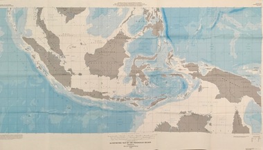
Map - Geological, U.S. Government Printing Office, Bathymetric Map of the Indonesian Region: Folio of the Indonesian Region Map I-875-A, 1974, 1974
... economic commission...department of state...geological survey...Map was prepared on behalf of the Government of Indonesia, The United Nations Economic Commission for Asia and the Far East, the Agency for International Development and the U.S. Department of State in cooperation with the Geological Survey of Indonesia. ...Barker Library (top floor) Mount Helen goldfields Map was prepared on behalf of the Government of Indonesia, The United Nations Economic Commission for Asia and the Far East, the Agency for International Development and the U.S. Department of State in cooperation with the Geological Survey of Indonesia. ...Map was prepared on behalf of the Government of Indonesia, The United Nations Economic Commission for Asia and the Far East, the Agency for International Development and the U.S. Department of State in cooperation with the Geological Survey of Indonesia. The area covered shows the islands and seas from Latitude 12 degree North to 16 degrees South and Longitude 90 degrees to 148 degrees. Various water features are also named.Large map showing the Indonesian area - islands and seasLongitude and Latitude are shown. Major / Capitol cities indicated. Names of those responsible for the productionindonesia, united nations economic commission, department of state, geological survey, latitude, longitude, government of indonesia -
 Eltham District Historical Society Inc
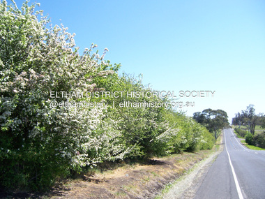
Photograph - Digital Photograph, Marguerite Marshall, Hawthorn hedges, Eltham-Yarra Glen Road, Kangaroo Ground, 3 October 2006
... economic power that saw the Shire of Eltham governed from Kangaroo Ground for 79 years (1858-1937). The Scots jealously guarded their land, so hard to get in Scotland. That is why they refused to release any of it ‘for local roads to follow easier grades as was the case in surrounding districts where roads generally followed ridgelines or streams’.3 Instead the roads were built in accordance with the magnetic bearings of their first survey in 1847 whether that suited the steep topography or not. ...economic power that saw the Shire of Eltham governed from Kangaroo Ground for 79 years (1858-1937). The Scots jealously guarded their land, so hard to get in Scotland. That is why they refused to release any of it ‘for local roads to follow easier grades as was the case in surrounding districts where roads generally followed ridgelines or streams’.3 Instead the roads were built in accordance with the magnetic bearings of their first survey in 1847 whether that suited the steep topography or not. ...Hawthorn hedges are important reminders of Kangaroo Ground's Scottish heritage. They are Registered on the Victorian Heritage Register. They are "historically significant because the planting of hawthorn hedges reflects the adoption of Eurorpean farming techniques by the Kangaroo Ground population in the period following settlement and because the grid pattern of paddocks that the Hawthorn hedges define is very different to today's farm landscapes." Covered under Heritage Overlay, Nillumbik Planning Scheme. Published: Nillumbik Now and Then / Marguerite Marshall 2008; photographs Alan King with Marguerite Marshall.; p21 Hawthorn hedges bordering Kangaroo Ground’s gently rolling farmlands are important reminders of its Scottish heritage and are rare so close to Melbourne.1 As early as the 1840s newly arrived farmers from Scotland planted hawthorn hedges around their properties, to protect crops from the numerous kangaroos and wallabies. Many of these hedges survive today. These farmers had the good fortune to settle some of the most fertile land available for cropping in the Colony of Victoria. At that time the black volcanic soil could sustain an amazing two crops a year. By the mid 1850s, 500 acres (202ha) of wheat were growing in Kangaroo Ground. But the crops were threatened by kangaroos, which were so plentiful, that Surveyor-General, Robert Hoddle, named the district Kangaroo Ground in 1838. As post-and-rail fences proved inadequate barriers for the bounding kangaroos, the Scots planted hawthorn hedgerows as they had done in Scotland. Some also used the hedges to net birds, presumably for the table. Interestingly the farmers in the bordering townships of Panton Hill and Christmas Hills, did not plant hawthorn hedges around their properties. Perhaps it was because by the time they settled in the 1860s and 1870s most of the wildlife had been gunned down by residents.2 The canny Scots planted the hedges on public land outside their own farms, as the hedgerows could spread to about five yards (five m) in width. With this impenetrable barrier Kangaroo Ground’s industrious farmers flourished to gain the economic power that saw the Shire of Eltham governed from Kangaroo Ground for 79 years (1858-1937). The Scots jealously guarded their land, so hard to get in Scotland. That is why they refused to release any of it ‘for local roads to follow easier grades as was the case in surrounding districts where roads generally followed ridgelines or streams’.3 Instead the roads were built in accordance with the magnetic bearings of their first survey in 1847 whether that suited the steep topography or not. This could force traffic to diverge when wet through Greensborough and Diamond Creek. Until 1921, the Eltham-Yarra Glen Road beside Wellers Restaurant, ‘dipped down into the upper reaches of Stony Creek’.4 Later some corners were compulsorily cut for the increasing motor traffic. As late as the 1960s, corners were cut to form sweeping curves above and alongside the Kangaroo Ground Cemetery and opposite the Emergency Operations Centre. In the latter case, the farmers – understanding their hedgerows as important heritage – insisted upon their reinstatement to conform to the altered road alignment. Kangaroo Ground’s ancient manna gums also point to the district’s history and to that of the hedgerows. The Aboriginal people had transformed the original forests into grasslands with the fires they lit to attract kangaroos, (which the Scots were to exclude by planting hedgerows). But the Wurundjeri hunters left the gums (Eucalyptus vimminalis cygnetensis), on the grasslands as ‘stalking trees’ to hunt kangaroos. The hawthorn hedges in Kangaroo Ground were neglected for around 60 years from about the middle of the 20th century. Bushfires had created gaps and the hedgerows were not trimmed. Then in late 2005, local historian Mick Woiwod, formed a group to lobby the Nillumbik Shire to restore the hedges, which could last for many centuries. Some hedges in parts of Britain date back to AD 800.5 Although the original Scottish farmers have gone, the hedges are a reminder of when they flourished in the district, which has changed little in 150 years.This collection of almost 130 photos about places and people within the Shire of Nillumbik, an urban and rural municipality in Melbourne's north, contributes to an understanding of the history of the Shire. Published in 2008 immediately prior to the Black Saturday bushfires of February 7, 2009, it documents sites that were impacted, and in some cases destroyed by the fires. It includes photographs taken especially for the publication, creating a unique time capsule representing the Shire in the early 21st century. It remains the most recent comprehenesive publication devoted to the Shire's history connecting local residents to the past. nillumbik now and then (marshall-king) collection, eltham-yarra glen road, hawthorn hedgerow, kangaroo ground -
 The Beechworth Burke Museum
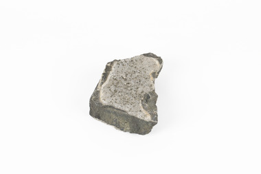
Geological specimen - Pyrite crystals in black slate, Unknown
... Survey of Victoria that begun in 1852 (in response to the Gold Rush). Collecting these specimens was an important part of Australia's early Geoplogical scientific discovery for mapping the earth's surface. It is unknown where in Victoria this specimen was mined from however; it shows strong provenance connections to Victoria's gold mining history and represents through larger economic and cultural structures the impact the Gold Rush had on Victoria during the 19th century. ...Pyrite also known as iron Pyrite or fools gold is an iron sulfide with a chemical formula of FeS2 and is the most abundant sulfide mineral. Its metallic luster and pale brass-yellow hue give it a superficial resemblance to gold for which its nickname of Fools Gold comes from. There are a number of iron pyrite mines in Victoria and many would have been mined during Victoria's Gold Rush revolution in the 19th century. As it's lustrius yellow metallic look closely resembles gold, it is likely that it was often mistaken for gold as real gold was also often found in similar metamorphic and sedimentary rock. This specimen is part of a larger collection of geological and mineral specimens collected from around Australia (and some parts of the world) and donated to the Burke Museum between 1868-1880. A large percentage of these collections were collected in Victoria as part of the Geological Survey of Victoria that begun in 1852 (in response to the Gold Rush). Collecting these specimens was an important part of Australia's early Geoplogical scientific discovery for mapping the earth's surface. It is unknown where in Victoria this specimen was mined from however; it shows strong provenance connections to Victoria's gold mining history and represents through larger economic and cultural structures the impact the Gold Rush had on Victoria during the 19th century. A solid coin-sized Pyrite crystal in black slate in shades of beige with tiny crystal structures. Pyrite / crystals / BB / in black slate / probably / victoria / (nice specimen)geology, geological specimen -
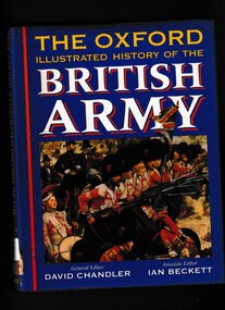 Monbulk RSL Sub Branch
Book, David Chandler, The Oxford illustrated history of the British Army, 1994
... survey shows how British fighting forces have evolved over the last five centuries. The continuities revealed are sometimes surprising: narrow recruitment patterns, friction between soldiers and civilians, financial constraints and recurrent political pressure for economies are constant themes. Commanders, campaigns, battles, organization, and weaponry are covered in detail within the wider context of the social, economic ...From longbow, pike, and musket to Challenger tanks, from the Napoleonic Wars to the Gulf campaign, the Duke of Marlborough to Field Marshal Montgomery, The Oxford Illustrated History of the British Army recounts the history of the British army from its medieval antecedents to the present day. Drawing on the latest scholarship, this survey shows how British fighting forces have evolved over the last five centuries. The continuities revealed are sometimes surprising: narrow recruitment patterns, friction between soldiers and civilians, financial constraints and recurrent political pressure for economies are constant themes. Commanders, campaigns, battles, organization, and weaponry are covered in detail within the wider context of the social, economic, and political environment in which armies exist and fight. The British army has been remarkably successful in fighting terms, losing only one major war (of American Independence 1775-83). As one of the engines of empire it has been active all over the world, as well as shaping the internal destiny of the nation in civil war and revolution. Its history is charted in a sequence of chronological chapters, each containing special feature articles, beginning with the medieval, Elizabethan, and Restoration army and moving on through the eighteenth and nineteenth centuries to the two world wars of the twentieth. The book concludes with accounts of the army of British India, the amateur military tradition, the British way in warfare, and an assessment of what the future may hold in the light of the Options for Change review. Extensively illustrated in black and white and colour, and with a detailed chronology and further reading lists, this is the definitive one-volume history of the British army for specialists and non-specialists alike.Bibliography, Index, Chronology, ill (plates, col, b/w) maps. p.452.non-fictionFrom longbow, pike, and musket to Challenger tanks, from the Napoleonic Wars to the Gulf campaign, the Duke of Marlborough to Field Marshal Montgomery, The Oxford Illustrated History of the British Army recounts the history of the British army from its medieval antecedents to the present day. Drawing on the latest scholarship, this survey shows how British fighting forces have evolved over the last five centuries. The continuities revealed are sometimes surprising: narrow recruitment patterns, friction between soldiers and civilians, financial constraints and recurrent political pressure for economies are constant themes. Commanders, campaigns, battles, organization, and weaponry are covered in detail within the wider context of the social, economic, and political environment in which armies exist and fight. The British army has been remarkably successful in fighting terms, losing only one major war (of American Independence 1775-83). As one of the engines of empire it has been active all over the world, as well as shaping the internal destiny of the nation in civil war and revolution. Its history is charted in a sequence of chronological chapters, each containing special feature articles, beginning with the medieval, Elizabethan, and Restoration army and moving on through the eighteenth and nineteenth centuries to the two world wars of the twentieth. The book concludes with accounts of the army of British India, the amateur military tradition, the British way in warfare, and an assessment of what the future may hold in the light of the Options for Change review. Extensively illustrated in black and white and colour, and with a detailed chronology and further reading lists, this is the definitive one-volume history of the British army for specialists and non-specialists alike.great britain - military history, great britain - military tradition -
 Bendigo Historical Society Inc.
Document - BENDIGO SALEYARDS COLLECTION: THE BENDIGO SALEYARDS ECONOMIC VIABILITY STUDY
... Contents include: Chapter 1 - Background Information, Chapter 1 - Present Operations at the Saleyards, Chapter 3 - Economic Factors, Chapter 4 - Environmental Factors, Chapter 5 - Selling Techniques, Chapter 6 - Employment Study, Management and Sundry Issues, Chapter 7 - Survey of Farmers and Saleyard Users in the 'Catchment Area', and Chapter 8 - Recommendations of the Report. ...Contents include: Chapter 1 - Background Information, Chapter 1 - Present Operations at the Saleyards, Chapter 3 - Economic Factors, Chapter 4 - Environmental Factors, Chapter 5 - Selling Techniques, Chapter 6 - Employment Study, Management and Sundry Issues, Chapter 7 - Survey of Farmers and Saleyard Users in the 'Catchment Area', and Chapter 8 - Recommendations of the Report. ...140 Loose pages titled The Bendigo Saleyards Economic Viability Study. Report written by Kate Millard on behalf of the Bendigo Development Committee Inc. Contents include: Chapter 1 - Background Information, Chapter 1 - Present Operations at the Saleyards, Chapter 3 - Economic Factors, Chapter 4 - Environmental Factors, Chapter 5 - Selling Techniques, Chapter 6 - Employment Study, Management and Sundry Issues, Chapter 7 - Survey of Farmers and Saleyard Users in the 'Catchment Area', and Chapter 8 - Recommendations of the Report. Includes diagrams and maps. Recommendations printed on dark yellow paper.bendigo, council, cattle markets, bendigo saleyards collection - the bendigo saleyards economic viability study, bendigo development committee inc., kate millard, loddon campaspe planning authority, street, ryan and associates, bendigo city council, strathfieldsaye shire council, department of industry technology & resources, national library of australia, meldrum burows & partners, core wilson sayer, town planning appeals panel, ces, victorian farmers and graziers association, stock agents association, department of agriculture, department of industry technology & resources, department of conservation forests and land, cr jock comini, rca depot, wellsford rifle range, bendigo airport, bendigo field naturalists club, mr david kennedy, mr john brumby, mr john radford, neil o'keefe, bendigo east progress association, bendigo east traders, trades hall council, mr tom uren, mr frank wilkes, mr bruce reid, mr k i m wright, mr e t ebery, bendigo pastoral council of the vfga, victorian meatworks association, bendigo stock & station agents association, rutlands transport, mr don pickles, country abattoirs & wholesalers association association of victoria, meat and allied trade federation of australia, bendigo saleyards advisory committee, bendigo residents & ratepayers association, a h & n graham, mrs p unmack australian bureau of statistics, mr lloyd houlden, cr c rodda, mr jolly, mr tony milanese, dr robert carter, university of melbourne, bendigo college of tafe, t matthews, a s & r d rutland, john kerr, j talbot, g l o'sullivan, penney & lang pty ltd, graeme pickering, pickhall j w & sons, r a plant, w k schmidt, t j vick, k & j wignall, a e wright, g chapman, a j gillies, p g & m m harris, ian r hollingsworth, b kennedy, s letcher, s & d k letcher, p m llewellyn, l g mason, boyer r t, connally m f, kennedy & mortlock, nevins j p, r w johnstone, w j keith, b d kelly, notman r, pitts a j & c a, pitts mervyn l & co, rowe w o, warren k m, associated stock & station agents, dalgety farmers ltd, elders dsm estates, ellis nuttall & co, gallagher g d, hamilton real estate, mcgregor ralph h & co, mckean w & co, miller turner livestock co, vains e m & co, victorian producers, hill m j & co, bennetts meats, comell bros, davis b & d, hardwick g f & v c, penney & lang p/l, tendercut meats, northern seed supply co, bendigo fertilizers, agri business pty ltd, agrilink consulting group pty ltd, acil aust pty ltd, mcgowan & associates, chapman w c, talbot e j, mcculloch w & sons pty ltd, k v equipment, commercial egg producers assoc co-op, monsanto aust ltd, balmer bryan r, barry i j, bath l, clarke b j, treacy k m, turner j m, bendigo mower serv pty ltd, everlast concrete tank tyltd, wicks bros, canvas goods, don mcarthur, bendigo communications, transcom, emdell pty ltd, epsom pharmaceutical supplies, sandhurst fencing pty ltd, arnolds gates & fencing, r furniss, carne neville, awa & unicla, ajm refrigeration, bendigo concrete sawing service, hamilton r j, hearpes t w, j e brown, campey dr a r, fyffe j j, kangaroo flat vet clinic, ottrey k e, bendigo sprinkler installations, milnes irrigation, onga pumpshop, barastoc products, bush's produce stores, epsom produce, k m m pty ltd, bendigo grain co, eaglehawk chaff mills, grain elevators board dept, bonneys pest control, knights pest control, brown wk & l d, bendigo sewerage authority, bendigo water board, aci computer services, leham donald, a e hueffer & associates, wolmoke planners, p langley, mr ken strachan, mr evan jones, mr peter byrnes, mr wayne street, street ryan & associates -
 Federation University Historical Collection
Book, William Harvey Emmons, The Principles of Economic Geology, 1940, 1940
... Survey. charles bacon mining engineering metallurgy university of nevada mackay school of mines geology california Inside front cover "Charles Bacon 1940 Lincoln Hall Ass. University of Nevada Reno, Nevada" Maroon soft covered book of 529 pages. Chapters include Magmatic Segregations, Pegmatities, Hypothermal Deposits, Sedimentary Depostis, Openings in Rocks, Metasomatic Processes, Mineral Associations and more. The Principles of Economic ...The book was used by Charles Bacon who studied at the University of Nevada in the late 1930s/early 1940s. Bacon worked at Bunker Hill Mines and Kellogg Idaho, before arriving in Australian in 1951. He worked for CN Myers, a company involved with paper converting. CN Myers was a family business (on Charles Bacon's maternal line). William Emmons was Professor and head of Geology and Mineralogy at the University of Minnesota; Director of Minnesota geological Survey; and previously Geologist, Section of Metalliferous Deposits, United States Geological Survey.Maroon soft covered book of 529 pages. Chapters include Magmatic Segregations, Pegmatities, Hypothermal Deposits, Sedimentary Depostis, Openings in Rocks, Metasomatic Processes, Mineral Associations and more.Inside front cover "Charles Bacon 1940 Lincoln Hall Ass. University of Nevada Reno, Nevada"charles bacon, mining engineering, metallurgy, university of nevada, mackay school of mines, geology, california -
Federation University Historical Collection
Book, Tourism & Marketing Unit, Ballarat University College, Grampians Tourist Survey - Summary Results January-December, 1991, 1991
... Survey - Summary Results January-December, 1991. Tourism & Marketing Unit, Ballarat University College, Students' Project. ballarat university college grampians stawell introduction methodology results conclusion stawell and grampians economic development association halls gap grampians national park great ocean road victorian otways mckenzie falls wonderland forest brambuk cultural centre grampians/gariwerd region White bound book of 12 pages plus 15 tables and 1 appendix. ...Grampians Tourist Survey - Summary Results January-December, 1991. Tourism & Marketing Unit, Ballarat University College, Students' Project.White bound book of 12 pages plus 15 tables and 1 appendix.ballarat university college, grampians, stawell, introduction, methodology, results, conclusion, stawell and grampians economic development association, halls gap, grampians national park, great ocean road, victorian otways, mckenzie falls, wonderland forest, brambuk cultural centre, grampians/gariwerd region -
Lakes Entrance Historical Society
Book, Hancock, Keith, Australian Society, 1989
... Lakes Entrance Historical Society 4 Marine Parade Lakes Entrance gippsland Economic History A survey of the social history of Australia, prepared to celebrate the Australian Bicentennial 1988. ...A survey of the social history of Australia, prepared to celebrate the Australian Bicentennial 1988. Includes Bibliography and Index.economic history -
Lakes Entrance Historical Society
Book, Central Planning Authority, Victoria, Resources Survey East Gippsland Region, 1954
... Lakes Entrance Historical Society 4 Marine Parade Lakes Entrance gippsland Primary industry A review of the physical, economic, and public resources of East Gippsland, Victoria. Resources Survey East Gippsland Region Book Central Planning Authority, Victoria ...A review of the physical, economic, and public resources of East Gippsland, Victoria.primary industry -
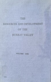 Wodonga & District Historical Society Inc
Book - The Resources and Development of the Murray Valley - Volume 1
... economic resource. Murray River Development Murray Basin Murray River Resources This report by the Murray Valley Resources Survey Committee is a detailed analysis of Importance and future the Murray River Valley and Basin for the economic development of Australia. ...This report by the Murray Valley Resources Survey Committee is a detailed analysis of Importance and future the Murray River Valley and Basin for the economic development of Australia. It includes a lengthy Foreword written by Prime Minister, Robert Menzies. A map of Australia with the Murray Valley River and Basin shaded in green, and a fold-out detailed map of the Murray River are featured.A small publication in a bound blue cover with black text. This report by the Murray Valley Resources Survey Committee is a detailed analysis of Importance and future the Murray River Valley and Basin for the economic development of Australia. It includes a lengthy Foreword written by Prime Minister, Robert Menzies. A map of Australia with the Murray Valley River and Basin shaded in green, and a fold-out detailed map of the Murray River are featured.murray river development, murray basin, murray river resources -
Koorie Heritage Trust
Book, Broome, Richard, Aboriginal Australians. Black Responses to white Dominance 1788-1994. (Second Edition), 1994
... . | Economic sectors - Agriculture and horticulture - Pastoral industry - Beef cattle | Religions - Christianity - Missions | Settlement and contacts - 20th Century | Enterprises - Pastoral industry | Government policy - Assimilation | Government policy - Initial period and protectionism | Government policy - Integration | Government policy - State and territory - New South Wales | Government policy - State and territory - Victoria | Law - Land | Land rights - Mining industry | Land rights - Pastoral industry | Socioeconomic conditions - Living conditions | Occupations - Pastoral industry workers | Law enforcement - Police - Native police | Law enforcement - Police conduct and attitudes | Politics and Government - Political action - Land rights | Race relations - Violent - Massacres murders poisonings etc. - To 1900 | Race relations - Racism - Stereotyping | Surveys traditional life and values, confrontations with the British; violent conflicts with settlers, native police throughout the country; attacks on Aboriginal initiative at Coranderrk, Cumeroogunja and other settlements; racial legislation, missionary attitudes; cattle industry, mining; discrimination; growth of Aboriginal rights movement, Aboriginal organizations, land rights. 4-275 P.; plates; ill,; appendices; notes; bib.; index; 22 cm. ...Surveys traditional life and values, confrontations with the British; violent conflicts with settlers, native police throughout the country; attacks on Aboriginal initiative at Coranderrk, Cumeroogunja and other settlements; racial legislation, missionary attitudes; cattle industry, mining; discrimination; growth of Aboriginal rights movement, Aboriginal organizations, land rights.4-275 P.; plates; ill,; appendices; notes; bib.; index; 22 cm.Surveys traditional life and values, confrontations with the British; violent conflicts with settlers, native police throughout the country; attacks on Aboriginal initiative at Coranderrk, Cumeroogunja and other settlements; racial legislation, missionary attitudes; cattle industry, mining; discrimination; growth of Aboriginal rights movement, Aboriginal organizations, land rights.aboriginal australians -- social conditions. | race discrimination -- australia. | australia -- race relations. | economic sectors - agriculture and horticulture - pastoral industry - beef cattle | religions - christianity - missions | settlement and contacts - 20th century | enterprises - pastoral industry | government policy - assimilation | government policy - initial period and protectionism | government policy - integration | government policy - state and territory - new south wales | government policy - state and territory - victoria | law - land | land rights - mining industry | land rights - pastoral industry | socioeconomic conditions - living conditions | occupations - pastoral industry workers | law enforcement - police - native police | law enforcement - police conduct and attitudes | politics and government - political action - land rights | race relations - violent - massacres, murders, poisonings etc. - to 1900 | race relations - racism - stereotyping | -
 Mrs Aeneas Gunn Memorial Library
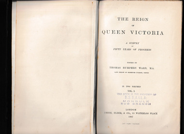
Book, Smith Elder and Co, The reign of Queen Victoria : a survey of fifty years of progress v.1, 1887
... Mrs Aeneas Gunn Memorial Library via Monbulk RSL, 48 Main Rd Monbulk yarra-valley-and-the-dandenong-ranges Great Britain - Social conditions - 19th century Great Britain - Economic conditions - 19th century A study of the history of Great Britain during the reign of Queen Victoria Map, p.594. The reign of Queen Victoria : a survey ...A study of the history of Great Britain during the reign of Queen VictoriaMap, p.594.non-fictionA study of the history of Great Britain during the reign of Queen Victoriagreat britain - social conditions - 19th century, great britain - economic conditions - 19th century -
 Mrs Aeneas Gunn Memorial Library
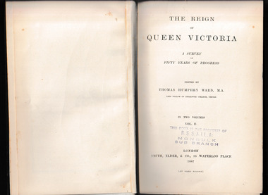
Book, Smith Elder and Co, The reign of Queen Victoria : a survey of fifty years of progress v.2, 1887
... Mrs Aeneas Gunn Memorial Library via Monbulk RSL, 48 Main Rd Monbulk yarra-valley-and-the-dandenong-ranges Great Britain - Social conditions - 19th century Great Britain - Economic conditions - 19th century A study of the history of Great Britain during the reign of Queen Victoria Map, p.620. The reign of Queen Victoria : a survey ...A study of the history of Great Britain during the reign of Queen VictoriaMap, p.620.non-fictionA study of the history of Great Britain during the reign of Queen Victoriagreat britain - social conditions - 19th century, great britain - economic conditions - 19th century -
 Bendigo Historical Society Inc.
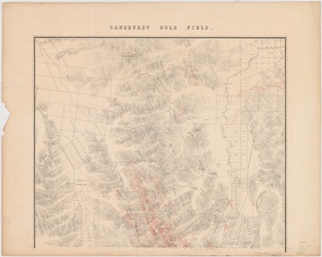
Map - Sandhurst Goldfield 1873, 1873
... In November 1869 he superintended the establishment of a museum of economic geology, mineralogy and mining and published in Melbourne The Gold Fields and Mineral Districts of Victoria … Covertly involved in the controversy that led to the disbanding of the Geological Survey in 1869, he became its director on its reinstatement in 1871; he increased its part in the search for and proving of economic mineral and coal deposits. ...In November 1869 he superintended the establishment of a museum of economic geology, mineralogy and mining and published in Melbourne The Gold Fields and Mineral Districts of Victoria … Covertly involved in the controversy that led to the disbanding of the Geological Survey in 1869, he became its director on its reinstatement in 1871; he increased its part in the search for and proving of economic mineral and coal deposits. ...Robert Brough Smyth (1830-1889), civil servant and mining engineer, was born on 18 February 1830 near Wallsend, Northumberland, England, son of Edward Smith, mining engineer, and his wife Elizabeth, née Brough. On 14 November 1852 Smyth arrived in Melbourne and went to the gold diggings, where he worked as a carter on the construction of roads at Sawpit Gully. Back in Melbourne, on 7 November 1853 he became a draftsman under the surveyor-general, Andrew Clarke, and soon was acting chief draftsman. Smyth compiled numerous reports and wrote catalogues for exhibitions of minerals and fossils. In November 1869 he superintended the establishment of a museum of economic geology, mineralogy and mining and published in Melbourne The Gold Fields and Mineral Districts of Victoria … Covertly involved in the controversy that led to the disbanding of the Geological Survey in 1869, he became its director on its reinstatement in 1871; he increased its part in the search for and proving of economic mineral and coal deposits. In 1875 he became chief inspector of mines and published the geological reports on John Forrest's Western Australian exploration. On 19 June 1860 Smyth had become honorary secretary to the Board for the Protection of Aborigines and in 1863 became a voting member. Zealous and determined, he assumed the role of chairman, which belonged ex officio to the chief secretary, and wielded great power, including the dubious dismissal of John Green, general inspector of Aborigines in 1861-75 with whom he had earlier collaborated. Smyth's compilation, The Aborigines of Victoria … (1878), arose from his efforts to gather information and artefacts of Victorian Aboriginal cultures at a time when their vestiges were fast disappearing. The work, still valuable though long since superseded, relied heavily upon others such as L. Fison, G. B. Halford, A. Howitt and J. Milligan. Press reports and a petition from officers in the Mining Department accused Smyth of 'tyrannical and overbearing conduct', and in February 1876 a board of inquiry was constituted and heard evidence until April. McCoy defended 'one of the best heads of department he had ever known' but the board found the charges of 'excessive severity … in the main substantiated', and reported that Smyth had been irritable, lacking self-control and over-fastidious, but acknowledged his 'unremitting energy and zealous labours in the public service'. On 4 May Smyth resigned all public offices except his membership of the Aborigines' board. Source: Australian Dictionary of Biography. https://adb.anu.edu.au/biography/smyth-robert-brough-4621Original map printed on paper on canvas; copy of map with original. Title: Sandhurst gold field [cartographic material] / surveyed and compiled under the direction of R. Brough Smyth and Thos. Couchman, Angus Mackay ; additions made to the survey under the same direction by Regd. A.F. Murray, April 1873. "Lithd. by R. Shepherd" Topographic map of Sandhurst gold field, with relief shown by hachures. Shows roads, railways and public buildings. "Note - blocks held under leasing regulations are outlined and numbered in red" Map is also available on State Library Victoria: https://find.slv.vic.gov.au/discovery/fulldisplay?vid=61SLV_INST:SLV&search_scope=slv_local&tab=searchProfile&context=L&docid=alma994975393607636 sandhurst, goldfield, lease holdings, gullies, brough smyth, state library of victoria -
Bendigo Historical Society Inc.
Letter - Michele Matthews Collection: PHD Research - Relief during the great depression, April 1934
... Finally, the Town Clerk notes that the project would generate wider economic benefits by creating additional full-wage employment in the manufacture of sewer pipes and in subsequent sewer construction and house connections. Because surveys...Finally, the Town Clerk notes that the project would generate wider economic benefits by creating additional full-wage employment in the manufacture of sewer pipes and in subsequent sewer construction and house connections. Because surveys ...Dr Michele Matthews has been a local and social historian for nearly three decades since she first used correspondence held by the then Bendigo City Council for her Honours thesis. She is an ardent advocate for the use of local history records to tell Victorian and Australian history from a grassroots perspective. Michele’s MA thesis, ‘A forgotten “Father” of Federation: Sir John Quick 1852‑1911’ (2003), and her PhD thesis, ‘Survivors, schemes, Samaritans and shareholders: the impact of the Great Depression on Bendigo and District 1925‑1935’ (2007), both drew heavily on Bendigo and district records. Michele Matthews Collection: PHD Research - Relief during the great depression This item includes the following documents: 8672.70a The document is a letter dated 23 April 1934 from the Town Clerk to the Assistant Minister in Charge of Sustenance regarding a proposal to provide employment for unemployed sustenance workers in Bendigo through the construction of a new sewer branch. The letter begins by expressing support for the government's policy of providing useful work in exchange for sustenance payments, but notes that difficulties have arisen in funding employment opportunities for the approximately 650 men still receiving sustenance in the city. It explains that while the government has recently funded labour-intensive drainage works in Melbourne, Bendigo has a pressing infrastructure problem that could similarly provide meaningful employment. The proposal focuses on a low-lying area in Bendigo where polluted drainage from houses has contaminated channels and waterways. The Town Clerk argues that the only effective solution is to construct a new independent branch sewer connected to the main outfall sewer. Under normal circumstances, the project would be financially impossible because the sparsely populated area could not generate sufficient sewerage rates to cover the capital costs. The letter emphasises that the project would have dual benefits. It would solve an important public health problem while providing winter employment for unemployed men. The Bendigo Sewerage Authority would contribute the costs of skilled labour, supervision, materials, and cartage (estimated at £1,220), while requesting government assistance to cover £1,980 in unskilled labour costs. This funding would provide approximately three months of winter work for around 150 sustenance workers, following the existing system of one week's work in every three. To finance the proposal, the Town Clerk suggests two alternatives. The first is to classify only the excavation work as approved sustenance work. The second is to provide a government grant covering the cost of unskilled labour, with workers being recruited through either the local Sustenance Office or Labour Bureau and employed under the same rotational arrangements already used for sustenance workers. The letter argues that either approach would maximise employment without requiring sustenance workers to undertake the specialised sewer construction itself. Finally, the Town Clerk notes that the project would generate wider economic benefits by creating additional full-wage employment in the manufacture of sewer pipes and in subsequent sewer construction and house connections. Because surveys and planning would need to begin before construction, the writer urges the government to consider the proposal as quickly as possible so that winter work can commence without delay.bendigo, michele matthews collection, letters seeking support in bendigo during the great depression 1932 to 1934