Showing 46 items matching "electoral maps"
-
 Melbourne Tram Museum
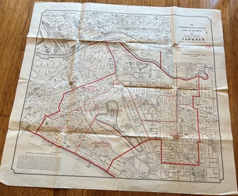
Map, Department of Lands and Survey Melbourne, Commonwealth Electoral Division of Fawkner, 1-10-1912
... ...Electoral maps...Folded sheet - Map - Commonwealth Electoral Division of Fawkner - two colours showing the subdivisions and polling places...Gives details of the Fawkner Electoral district in 1912. Melbourne Fawkner tram lines cable trams maps Electoral maps South Melbourne Albert Park Prahran Folded sheet - Map - Commonwealth Electoral Division of Fawkner - two colours showing the subdivisions and polling places Commonwealth Electoral Division of Fawkner Map Department of Lands and Survey Melbourne ...Shows a detailed street plan of South Melbourne, Albert Park, Prahran, South Yarra and parts of Melbourne in 1912. Used to mark the electoral boundaries of the Commonwealth Electoral Division of Fawkner. Shows all the then cable tram lines, rail lines and the electric line of the PMTT along with docks, gardens and significant buildings.Gives details of the Fawkner Electoral district in 1912.Folded sheet - Map - Commonwealth Electoral Division of Fawkner - two colours showing the subdivisions and polling placesmelbourne, fawkner, tram lines, cable trams, maps, electoral maps, south melbourne, albert park, prahran -
 Whitehorse Historical Society Inc.
Map, State Electoral Map, 1926
... State Electoral Map...State Electoral Map: Metropolitan and country areas, showing changes to electoral districts legislated in the Redistribution of Seats Bill 1926...Victoria Electoral boundaries State Electoral Map for 1926. State Electoral Map: Metropolitan and country areas, showing changes to electoral districts legislated in the Redistribution of Seats Bill 1926 State Electoral Map Map Map ...State Electoral Map for 1926.State Electoral Map: Metropolitan and country areas, showing changes to electoral districts legislated in the Redistribution of Seats Bill 1926State Electoral Map for 1926.victoria, electoral boundaries -
Stawell Historical Society Inc
Map - Electoral Map, Victorian Government, Map of North - Western ( Country) Electoral Province Legislative Council 1939, 1939
... Electoral Map...Map of North - Western ( Country) Electoral Province Legislative Council 1939...Electoral Map...Stawell Historical Society Inc 46 Longfield St Stawell grampians Electoral Map Government Scale 8 Miles to 1 Inch Map Overprinted with Provinces In Red Map of North - Western ( Country) Electoral Province Legislative Council 1939 Map Electoral Map Victorian Government ...Electoral MapMap Overprinted with Provinces In RedScale 8 Miles to 1 Inchgovernment -
Stawell Historical Society Inc
Map - Electoral Map, Federal Government, map of Commonwealth Electoral Division of Wimmera 1949, 1949
... Electoral Map...map of Commonwealth Electoral Division of Wimmera 1949...Electoral Map...Map overprinted with Electoral Divisions in Red. Description of Division of Wimmera ...Description of Division of Wimmera map of Commonwealth Electoral Division of Wimmera 1949 Map Electoral Map Federal Government ...Electoral MapMap overprinted with Electoral Divisions in Red. Description of Division of Wimmera Scale in Miles. Commonwealth of Australia State of Victoriagovernment -
Stawell Historical Society Inc
Map - Electoral Map, Local Government, Local Government Boundry Status as at 31st January 1995, 1995
... Electoral Map...Electoral map...Stawell Historical Society Inc 46 Longfield St Stawell grampians Electoral map Government Sheet 1 of 2 Sheet 2 of 2 Two (2) Maps Overprinted in Red Showing Local Government Boundries for State and port Phillip Area Local Government Boundry Status as at 31st January 1995 Map Electoral Map Local Government ...Electoral mapTwo (2) Maps Overprinted in Red Showing Local Government Boundries for State and port Phillip AreaSheet 1 of 2 Sheet 2 of 2government -
 Greensborough Historical Society
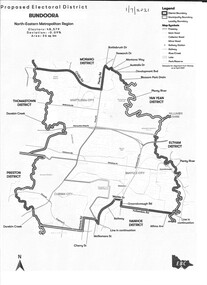
Map - Map (Copy), Electoral Boundaries Commission, Proposed electoral district: Bundoora, 01/07/2021
... electoral boundaries...bundoora - maps...Greensborough Historical Society 34A Glenauburn Road Lower Plenty Lower Plenty melbourne Proposed revised electoral boundaries for the electoral district of Bundoora (North-Eastern Metropolitan Region) as at 01/07/2021 electoral boundaries bundoora - maps victoria - parliament 1p. black and white copy of map Proposed electoral district: Bundoora Map Map (Copy) Electoral Boundaries Commission ...Proposed revised electoral boundaries for the electoral district of Bundoora (North-Eastern Metropolitan Region) as at 01/07/20211p. black and white copy of mapelectoral boundaries, bundoora - maps, victoria - parliament -
Port Melbourne Historical & Preservation Society
Map - Electoral Districts, 3 Aug 1876
... Map of Electoral Districts of Melbourne in two parts from 3 Aug 1876 including Sandrdige and Emerald Hill....Map Electoral Districts ...Map of Electoral Districts of Melbourne in two parts from 3 Aug 1876 including Sandrdige and Emerald Hill. -
Ballarat Tramway Museum
Map, Ballarat Litho & Printing Co, "Electoral Map of Ballarat", 1920's?
... "Electoral Map of Ballarat"...Map showing the electoral boundaries of Ballarat - State? ..."Electoral Map of Ballarat" Map Ballarat Litho & Printing Co ...Map showing the electoral boundaries of Ballarat - State? - possibly early 1920's. Has been marked up in blue pencil for electric and horse tram routes around Ballarat, along with names of terminals, depot, and other points of interest. Shows horse trams lines in Macarthur St and Armstrong St. Also has in pencil, approximate location of the railway to Buninyong. Map shows location of Showgrounds (old location), Hospital for epileptics, abattoirs, but does not show Ballarat North Railway Workshops. Title Block "Ballarat Litho & Ptg. Cos. / Electoral Map of / Ballarat / Scale 20 chains to One Inch" To be stored with minimal folding.trams, tramways, map, ballarat, horse trams -
Port Melbourne Historical & Preservation Society
Map - Electoral Districts, 3 Aug 1876
... Map of Electoral Districts of Melbourne in two parts from 3 Aug 1876 showing the area of Melbourne north of Sandridge....Map Electoral Districts ...Map of Electoral Districts of Melbourne in two parts from 3 Aug 1876 showing the area of Melbourne north of Sandridge. -
Glen Eira Historical Society
Book - GLEN EIRA GUIDE
... It includes information about Council meetings, the names and contact details of the six members of the Council, information about services offered by the Glen Eira Service Centre, the contact details for particular services offered by the Glen Eira City Council, information about rates and valuations, information about the building permit application process, information about waste management, and federal and state electoral maps. The second section, titled Council and Community Resource Guide, consists of a list of the various local community facilities and organizations. ...It includes information about Council meetings, the names and contact details of the six members of the Council, information about services offered by the Glen Eira Service Centre, the contact details for particular services offered by the Glen Eira City Council, information about rates and valuations, information about the building permit application process, information about waste management, and federal and state electoral maps. The second section, titled Council and Community Resource Guide, consists of a list of the various local community facilities and organizations. ...This file contains one item: 1/A copy of the 1999 edition of the Glen Eira guide. This magazine aims to provide readers with useful information for living and working within the City of Glen Eira. It is divided into five principal sections. The first section, titled Glen Eira City Council Information, provides information pertaining to the local government. It includes information about Council meetings, the names and contact details of the six members of the Council, information about services offered by the Glen Eira Service Centre, the contact details for particular services offered by the Glen Eira City Council, information about rates and valuations, information about the building permit application process, information about waste management, and federal and state electoral maps. The second section, titled Council and Community Resource Guide, consists of a list of the various local community facilities and organizations. The third section, titled City of Glen Eira Safe Food Guide, consists of a list of food venues nominated by the Glen Eira City Council Environmental Health Services Department for their commendable level of hygiene. The fourth section, titled City of Glen Eira Business Development Unit, provides information about the eponymous local government department, which is aimed at providing aid to local businesses. The fifth and final section, titled ‘Think Local, BUY LOCAL’ Guide, consists of a list of local businesses, grouped according to industry, to try and encourage the support thereof.glen eira, city of glen eira, glen eira city council, local government, local officials and employees, kennedy norman cr, mayors, public utilities, community services, local government departments, rates, local government, building permits, waste disposal, community groups, cultural structures and establishments, law and order, libraries, education, educational and research establishments, religious groups, clubs and associations, community centres, food, restaurants, businesses -
 Sunshine and District Historical Society Incorporated
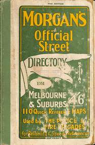
Book - Joseph 'Joe' Wlodarczyk Collection - Morgan's Official Street Directory 1951, Val Morgan & Sons Pty Ltd, Morgan's Official Street Directory 1951, 1951
... Academic and Community Research - Support civic projects: Community groups use them to document local stories, map historical events, or advocate for preservation. - Enable comparative studies: Researchers can analyze changes across decades by comparing editions. If you're working on something around Sunshine, Victoria, these directories are gold—especially when paired with rate books, electoral rolls, and maps. ...Academic and Community Research - Support civic projects: Community groups use them to document local stories, map historical events, or advocate for preservation. - Enable comparative studies: Researchers can analyze changes across decades by comparing editions. If you're working on something around Sunshine, Victoria, these directories are gold—especially when paired with rate books, electoral rolls, and maps. ...Hard copy book that includes a set of maps that cover the streets of MelbourneSmall hard covered book with green & yellow text on front. Inside has maps, index of street names & advertisementsnon-fictionHard copy book that includes a set of maps that cover the streets of Melbournedirectory, joseph 'joe' wlodarczyk, street directory -
Glen Eira Historical Society
Document - Goldstein, Vida
... Profile details of electoral division, updated 22/02/2012 plus map showing boundaries of Electoral Division of Goldstein gazette 24/12/2012....Profile details of electoral division, updated 22/02/2012 plus map showing boundaries of Electoral Division of Goldstein gazette 24/12/2012. ...One item on electoral division of Goldstein. Profile details of electoral division, updated 22/02/2012 plus map showing boundaries of Electoral Division of Goldstein gazette 24/12/2012.electoral boundaries, ‘goldstein’, vida goldstein, suffragist, feminist movement, maps -
 Bendigo Historical Society Inc.
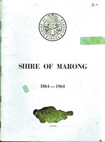
Book - SHIRE OF MARONG 1864 - 1964, 1964
... Contains Two (2) maps of the area on the inside back and front covers. Another illustration shows the division of the Electoral Boundaries and the types of Flora in each riding. ...Contains Two (2) maps of the area on the inside back and front covers. Another illustration shows the division of the Electoral Boundaries and the types of Flora in each riding. ...Shire of Marong 1864 - 1964. A history of the shire. Contains Two (2) maps of the area on the inside back and front covers. Another illustration shows the division of the Electoral Boundaries and the types of Flora in each riding. At the back is an illustration indicating the break-up of the area with the names of The First Settlers (?) in these area. Blue cover. 36 pages. With index. B&W photos.book, bendigo, marong shire -
 Greensborough Historical Society
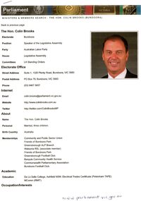
Document, Parliament of Victoria, Ministers & Members search - the Hon. Colin Brooks (Bundoora), 23/04/2021
... Colin Brooks, MLA for Bundoora, taken from Parliament of Victoria - Ministers and Members website; and, map of the electoral district of Bundoora....2 p. text and colour photograph, with colour map of Bundoora Electoral District...Colin Brooks, MLA for Bundoora, taken from Parliament of Victoria - Ministers and Members website; and, map of the electoral district of Bundoora. brooks family victoria parliament colin brooks bundoora 2 p. text and colour photograph, with colour map of Bundoora Electoral District Ministers & Members search - the Hon. ...Biographical details of the Hon. Colin Brooks, MLA for Bundoora, taken from Parliament of Victoria - Ministers and Members website; and, map of the electoral district of Bundoora.2 p. text and colour photograph, with colour map of Bundoora Electoral Districtbrooks family, victoria parliament, colin brooks, bundoora -
 Greensborough Historical Society
Document - Document Collection, Local Council Representation Review, 2019_
... Victorian Electoral Commission, August 2019. 31 p., text and colour maps. ...Victorian Electoral Commission, August 2019. 31 p., text and colour maps. Reports on submissions and gives 3 options for electoral review in Banyule. ...Contents: 2 x Newspaper Clippings: Banyule City Council Electoral Representative Review, Heidelberg Leader 20/08/2019 and Diamond Valley Leader 21/08/2019. Local Council Representative Review Submission Guide. Victorian Electoral Commission, 2019. 24 p., text. General information for those making a submission to a review. Local Council Representative Review Preliminary Report: Banyule City Council. Victorian Electoral Commission, August 2019. 31 p., text and colour maps. Reports on submissions and gives 3 options for electoral review in Banyule. Local Council Representative Review: Banyule City Council 1. Public hearing agenda and attachments. 25/09/2019. 9 p. 2. Public hearing agenda and attachments. 25/09/2019. 2 p. Agenda and handwritten notes by R. Bray. Local Council Representative Review Final Report: Banyule City Council. Victorian Electoral Commission, October 2019. 46 p., text and colour map. Recommends increasing the number of councillors and wards to 9. 2 newspaper clippings, 3 booklets and agenda with attachments. Filed in black plastic folder.banyule city council, victorian electoral commission, local council representative review 2019 -
 Greensborough Historical Society
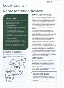
Document, BRAG submission to the VEC Representation Review, by Banyule Residents Action Group Inc, 2019_
... electoral representation in municipal areas. The last review of Banyule City Council was in 2007. banyule city council BRAG banyule residents action group 7 p. typescript with colour map BRAG submission to the VEC Representation Review, by Banyule Residents Action Group Inc. ...This is a submission to the Victorian Electoral Commission, which periodically reviews electoral representation in municipal areas. The last review of Banyule City Council was in 2007.7 p. typescript with colour mapbanyule city council, brag banyule residents action group -
 Greensborough Historical Society
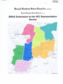
Folder, Victorian democracy and Greensborough, compiled by Anne Paul, 2019_06
... electoral districts and parliamentary members in the Greensborough and surrounding areas to date. Talk presented by Anne Paul to a GHS General meeting on 29 June 2019. greensborough victoria parliament anne paul 90 p. in loose leaf ring binder. Text, maps ...Outline of events leading to independent separate representative government for Victoria in 1850, and information on electoral districts and parliamentary members in the Greensborough and surrounding areas to date. Talk presented by Anne Paul to a GHS General meeting on 29 June 2019.90 p. in loose leaf ring binder. Text, maps and colour illustrations. Printed copy of PowerPoint presentationgreensborough, victoria parliament, anne paul -
 Eltham District Historical Society Inc
Document - Folder, Eltham Shire: Guide to historical sources held in the LaTrobe and Reference Library Collections, State Library of Victoria, 1980
... Sources are arranged in the following sections: bibliographies, books and pamphlets, serials, electoral rolls, directories, statistical material, maps, pictorial material and manuscripts....Sources are arranged in the following sections: bibliographies, books and pamphlets, serials, electoral rolls, directories, statistical material, maps, pictorial material and manuscripts. bibliography library Withdrawn copy from Yarra Plenty Regional Library 12 pages in a manilla folder Eltham Shire: Guide to historical sources held in the LaTrobe and Reference Library Collections, State Library of Victoria Document Folder ...Two copies. Folders 68 and 74 from Harry Gilham Collection. "The following work was undertaken at the request of the Shire Planner of the Shire of Eltham to aid in the establishment of a total inforamtion system for the Shire. It is primarily a guide to sources of historical information on the area within the present shire boundaries and also the additional areas which were within the shire's former boundaries". Sources are arranged in the following sections: bibliographies, books and pamphlets, serials, electoral rolls, directories, statistical material, maps, pictorial material and manuscripts.12 pages in a manilla folderWithdrawn copy from Yarra Plenty Regional Librarybibliography, library -
 Bendigo Historical Society Inc.
Document - RESEARCH FOLDER COLLECTION: WHITE HILLS HAMLET, 1990 - 2015
... White Hills Hamlet Includes Newspaper articles including many photographs of properties in the White Hills area advertised for sale Historical information about White Hills Hamlet properties Family history information about former residents of the White Hills area Notes based on electoral rolls, local directories, and rates records Maps...White Hills Hamlet Includes Newspaper articles including many photographs of properties in the White Hills area advertised for sale Historical information about White Hills Hamlet properties Family history information about former residents of the White Hills area Notes based on electoral rolls, local directories, and rates records Maps Document RESEARCH FOLDER COLLECTION: WHITE HILLS HAMLET ...Folder of research material compiled by Carol Holsworth. Received at History House in July 2023. White Hills Hamlet Includes Newspaper articles including many photographs of properties in the White Hills area advertised for sale Historical information about White Hills Hamlet properties Family history information about former residents of the White Hills area Notes based on electoral rolls, local directories, and rates records MapsCarol Holsworthbendigo, history, white hills hamlet -
Port Melbourne Historical & Preservation Society
Document - Voters Rolls, District of Sandridge
... Five (5) municipal electoral rolls(photocopies), District of Sandridge 1861; 1862; 1863; 1865; 1866 Photocopy of 1860 map, catalogue no 2083...Port Melbourne Historical & Preservation Society Port Melbourne Town Hall 333 Bay Street Port Melbourne melbourne local government - borough of sandridge Five (5) municipal electoral rolls(photocopies), District of Sandridge 1861; 1862; 1863; 1865; 1866 Photocopy of 1860 map, catalogue no 2083 Document Voters Rolls, District of Sandridge ...Five (5) municipal electoral rolls(photocopies), District of Sandridge 1861; 1862; 1863; 1865; 1866 Photocopy of 1860 map, catalogue no 2083local government - borough of sandridge -
 Ringwood and District Historical Society
Book, City of Ringwood, City of Ringwood 1993 Community Guide, 1993
... Greg Adkins, J.P. 3 Councillors 4 Council & Committee Cycle 5 Council Elections 6 History of Ringwood 7 Chief Executive's Report 8 The Management Team 9 Functional Responsibilities 10 Community Liaison 11 Council Expenditure for 1992/93 12 Rates and Valuations 13 COUNCIL SERVICES Community Services 14 Protecting the Environment 17 Protecting Our Community 19 Town Planning 21 Building 22 Design and Investigation 23 Works 24 Street Index - Electoral Wards 25 Neighbourhood Map 26 and 27 COUNCIL RECREAION AND LEISURE FACILITIES Ringwood Golf Course 29 Aquatic Centre 30 The Ringwood Convention Centre 32 Ringwood Library 34 Ringwood Recreation 35 Parks and Reserves 30 Community Directory 38-50 Community Information Data Bank 51 Aquatic Centre Vouchers 51...Greg Adkins, J.P. 3 Councillors 4 Council & Committee Cycle 5 Council Elections 6 History of Ringwood 7 Chief Executive's Report 8 The Management Team 9 Functional Responsibilities 10 Community Liaison 11 Council Expenditure for 1992/93 12 Rates and Valuations 13 COUNCIL SERVICES Community Services 14 Protecting the Environment 17 Protecting Our Community 19 Town Planning 21 Building 22 Design and Investigation 23 Works 24 Street Index - Electoral Wards 25 Neighbourhood Map 26 and 27 COUNCIL RECREAION AND LEISURE FACILITIES Ringwood Golf Course 29 Aquatic Centre 30 The Ringwood Convention Centre 32 Ringwood Library 34 Ringwood Recreation 35 Parks and Reserves 30 Community Directory 38-50 Community Information Data Bank 51 Aquatic Centre Vouchers 51 Community information book issued by City of Ringwood for 1993 - covering the facilities and activities of the Ringwood Council and other local organisations and associations. ...Community information book issued by City of Ringwood for 1993 - covering the facilities and activities of the Ringwood Council and other local organisations and associations. Includes two Ringwood Aquatic Centre bonus entry vouchers valid until June 30th, 1993. Cover photographs: Front - Poppet Head, Ringwood Lake; Back - Opening of North Ringwood Child Care Centre. CONTENTS: (page no.) Message from the Mayor – Cr. Greg Adkins, J.P. 3 Councillors 4 Council & Committee Cycle 5 Council Elections 6 History of Ringwood 7 Chief Executive's Report 8 The Management Team 9 Functional Responsibilities 10 Community Liaison 11 Council Expenditure for 1992/93 12 Rates and Valuations 13 COUNCIL SERVICES Community Services 14 Protecting the Environment 17 Protecting Our Community 19 Town Planning 21 Building 22 Design and Investigation 23 Works 24 Street Index - Electoral Wards 25 Neighbourhood Map 26 and 27 COUNCIL RECREAION AND LEISURE FACILITIES Ringwood Golf Course 29 Aquatic Centre 30 The Ringwood Convention Centre 32 Ringwood Library 34 Ringwood Recreation 35 Parks and Reserves 30 Community Directory 38-50 Community Information Data Bank 51 Aquatic Centre Vouchers 51rinx -
 Federation University Historical Collection
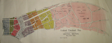
Plan - Plans, Tulloch & King, Federal Electoral Map Subdivision of Ballarat, c1901
... Federal Electoral Map Subdivision of Ballarat......electoral map...The first member of Ballarat was Alfred Deakin. ballarat federation alfred deakin elections plan electoral division electoral map polling May of the Federal subdivision of Ballarat, with each section depicted in a different colour. ...It is thought that these are the first federal electorial plans for the Subdivision of Ballarat. The first member of Ballarat was Alfred Deakin.May of the Federal subdivision of Ballarat, with each section depicted in a different colour. The plans include Lake Wendouree, Central Ballarat subdivision; Soldiers Hill subdivision; Ballarat East subdivision, and Central Section Ballarat East, including the Ballarat East Botanic Garden .ballarat, federation, alfred deakin, elections, plan, electoral division, electoral map, polling -
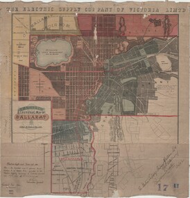 Ballarat Tramway Museum
Map, Electric Supply Co. of Vic (ESCo), Ballarat Electoral Map - ESCo, 1900
... Ballarat Electoral Map - ESCo...Cloth backed paper map, coloured and marked up as exhibit 17. Ballarat Electoral Map - ESCo Map Electric Supply Co. of Vic (ESCo) F W Niven & Co ...Document prepared by the Electric Supply Co of Victoria, as part of an order under the Electric Light and Power Act 1896, section 5 of order No. 17 granted to company. Dated 19/2/1901 and signed by the Postmaster-General. Shows the order area being parts of the City of Ballaarat, Sebastopol and Ballarat East. Shows the street names, boundaries, principal power line routes, land reserves, parks, mine locations, railways and Lake Wendouree. Signed by R L Williams Town Clerk City of Ballarat, J R Hall for the Borough of Sebastopol, and John Gent for the Town of Ballarat EastYields information about the power supply to the Ballarat area.Cloth backed paper map, coloured and marked up as exhibit 17.Notes in ink including the signature of Benjamin Deakin 24/9/00 and certified by the three involved municipal Town Clerks.ballarat power supply, esco, electric supply co of victoria, city of ballaarat, east ballarat, sebastopol, orders, power lines, power supply -
 Bendigo Historical Society Inc.
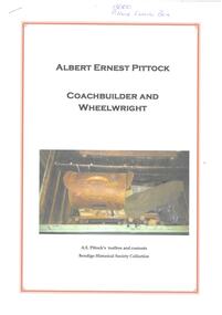
Document - PITTOCK COLLECTION: BHS RESEARCH ALBERT ERNEST PITTOCK COACHBUILDER AND WHEELWRIGHT
... (Rowe) Pittock, married on 18 July 1900 * map, Joyce's Creek, Newstead * 1903 - 1925 electoral roll details for A.E. ...(Rowe) Pittock, married on 18 July 1900 * map, Joyce's Creek, Newstead * 1903 - 1925 electoral roll details for A.E. ...BHS research - Albert Ernest Pittock Coachbuilder and Wheelwright detailing A.E. Pittock's toolbox and contents * Newspaper clippings celebrating wedding of Mr. A.E. and Mrs. A.H. (Rowe) Pittock, married on 18 July 1900 * map, Joyce's Creek, Newstead * 1903 - 1925 electoral roll details for A.E. Pittock * A. E. Pittock timeline * Death notice for A.E. Pittock on 24 April 1953 * Photo of burial site of both A.E. & A.H. Pittock * Primitive Methodist Sabbath School 1 Nov. 1887BHS research -
 Sunshine and District Historical Society Incorporated
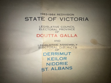
Map - 1983 - 1984 State of Victoria Legislative Council of Doutta Galla and Legislative Assemby Electoral Districts of Derrimut Keilor Niddre St. Albans, 1983
... Albans showing the proposed boundaries of the electoral areas Folded map Map 1983 - 1984 State of Victoria Legislative Council of Doutta Galla and Legislative Assemby Electoral Districts of Derrimut Keilor Niddre St. ...Part of the Gwen Goedecke Collection1983 - 1984 State of Victoria Legislative Council of Doutta Galla and Legislative Assemby Electoral Districts of Derrimut Keilor Niddrie St. Albans showing the proposed boundaries of the electoral areas -
Lakes Entrance Historical Society
Map - Proposed Electoral Division Gippsland 1962, A C Brooks, 1962
... Lakes Entrance Historical Society 4 Marine Parade Lakes Entrance gippsland Administrative record Government voting Commonwealth of Australia distribution of the State of Victoria into electoral Divisions. Map Proposed Electoral Division Gippsland 1962 A C Brooks ...Commonwealth of Australia distribution of the State of Victoria into electoral Divisions.non-fictionadministrative record, government, voting -
Lakes Entrance Historical Society
Map - Electoral Divisions of Gippsland 1962, Dept of Lands and Survey, 1962
... Map of proposed Commonwealth electoral divisions of Gippsland showing boundaries and names of Parishes....Map Electoral Divisions of Gippsland 1962 Dept of Lands and Survey A C Brooks Govv. ...Map of proposed Commonwealth electoral divisions of Gippsland showing boundaries and names of Parishes.Proposed Division of Gippslandsettlement, government planning -
 Victorian Aboriginal Corporation for Languages
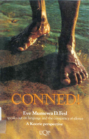
Book, Eve Mumewa D Fesl, Conned!, 1993
... Victorian Aboriginal Corporation for Languages 33 Saxon Street Brunswick melbourne Aboriginal Languages Association ATSIC education electoral system Moravian maps, b&w illustrations, b&w photographs, charts Language is power. ...Language is power. It is used to describe and direct events fictional and true. This book describes how historians have manufactured a flattering Australian race relations history. Conned! challenges established perceptions of Indigenous Australians.maps, b&w illustrations, b&w photographs, chartsaboriginal languages association, atsic, education, electoral system, moravian -
 Kew Historical Society Inc
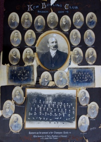
Photograph, Kew Bowling Club, Runners up for Pennant and for Championship Rink; Office Bearers of Club and Members of Pennant and Champion Rink Teams, 1908-9
... The background of these men has been identified by John Torpey as follows: BRADSHAW William Henry, grocer, 6 Cotham Road, Kew & 33 Prospect Hill Road, Camberwell - CARNEGIE J Lewis, merchant, Studley Avenue, Kew [Carnegie & Sons, piano & organ importers 106 Elizabeth Street, Melbourne] - CLARKE Charles, warehouseman, 35 Queen Street, Kew - EDGAR Robert McCutcheon, 215 High Street, Kew - FINLAYSON John Marshall, solicitor, 178 Cotham Road, Kew - GREEN Charles Henry, clerk, 81 Wellington Street, Kew - GREENHILL F snr [not found] - GREENHILL Thomas jnr, traveller, High Street south, Kew - HAMBLETON Lincoln, civil servant, 32 Coleridge Street, Kew - HANDBURY John, manufacturer, 55 Walpole street, Kew - JELLIS Thomas G, baker, Princess Street, Kew - LILBURN William Hugh solicitor, Denmark Street, Kew - MANSFIELD Allan, plumber, 150 Cotham Road, Kew [S&McD] or 21 Belmont Avenue, Kew [Electoral Roll 1909] - NATHAN Simeon, warehouseman, 59 Sackville Street, Kew - NIVEN Henry N, 192 Barkers Road, Kew [FW Niven & Co 40-42 Flinders Street, Melbourne, printers & lithographers] - SIMONTON Alan Thompson, dairyman, Belmont Avenue, Kew - SINUCH WC [not known – bottom right of frame] - SWINBURNE George [see Australian Dictionary of Biography] - TREDENNICK William, civil servant 285 Tennyson Street, Kew - WENTWORTH William Dalton, painter, 5 Derrick Street, Kew - WOOLLARD Thomas, civil servant, Hildebrand Crescent, Hawthorn - WOOLLARD Walter Herbert, builder, 35 Disraeli Street, Kew [Sources: Sands & McDougall directories, Electoral Roll 1909] The photographic collage is historically important as it includes rare photographs of local identities, many of whom were significant civic actors statewide. kew bowling club "Kew Bowling Club / Season 1908-9 / Runners up for pennant and for Championship Rink / Office bearers of Club and Members of Pennant and Champion Rink Teams". Large photo collage created by Barroni & Co (Melb) of team, player and official portraits of members of the Kew Bowling Club. At one stage the item was in a drawer in a map ...The Kew Bowling Club was formed in 1880 and merged with Auburn Heights Recreation Club in 1998. In addition to the unnamed members of the teams, the following individuals are profiled on the item. The background of these men has been identified by John Torpey as follows: BRADSHAW William Henry, grocer, 6 Cotham Road, Kew & 33 Prospect Hill Road, Camberwell - CARNEGIE J Lewis, merchant, Studley Avenue, Kew [Carnegie & Sons, piano & organ importers 106 Elizabeth Street, Melbourne] - CLARKE Charles, warehouseman, 35 Queen Street, Kew - EDGAR Robert McCutcheon, 215 High Street, Kew - FINLAYSON John Marshall, solicitor, 178 Cotham Road, Kew - GREEN Charles Henry, clerk, 81 Wellington Street, Kew - GREENHILL F snr [not found] - GREENHILL Thomas jnr, traveller, High Street south, Kew - HAMBLETON Lincoln, civil servant, 32 Coleridge Street, Kew - HANDBURY John, manufacturer, 55 Walpole street, Kew - JELLIS Thomas G, baker, Princess Street, Kew - LILBURN William Hugh solicitor, Denmark Street, Kew - MANSFIELD Allan, plumber, 150 Cotham Road, Kew [S&McD] or 21 Belmont Avenue, Kew [Electoral Roll 1909] - NATHAN Simeon, warehouseman, 59 Sackville Street, Kew - NIVEN Henry N, 192 Barkers Road, Kew [FW Niven & Co 40-42 Flinders Street, Melbourne, printers & lithographers] - SIMONTON Alan Thompson, dairyman, Belmont Avenue, Kew - SINUCH WC [not known – bottom right of frame] - SWINBURNE George [see Australian Dictionary of Biography] - TREDENNICK William, civil servant 285 Tennyson Street, Kew - WENTWORTH William Dalton, painter, 5 Derrick Street, Kew - WOOLLARD Thomas, civil servant, Hildebrand Crescent, Hawthorn - WOOLLARD Walter Herbert, builder, 35 Disraeli Street, Kew [Sources: Sands & McDougall directories, Electoral Roll 1909]The photographic collage is historically important as it includes rare photographs of local identities, many of whom were significant civic actors statewide.Large photo collage created by Barroni & Co (Melb) of team, player and official portraits of members of the Kew Bowling Club. At one stage the item was in a drawer in a map cupboard, fractured into multiple pieces. The items were later assembled some years ago Graham Lindsay and framed in 2021 for exhibition by John Torpey. "Kew Bowling Club / Season 1908-9 / Runners up for pennant and for Championship Rink / Office bearers of Club and Members of Pennant and Champion Rink Teams".kew bowling club -
Kew Historical Society Inc
Administrative record, City of Kew, City of Kew Voters Roll 1986-1987 Central Ward, 1986-1987
... maps, fashion and artefacts. Reference books have entered the collection through donation, presentation, collection and purchase. local government -- electoral rolls -- kew (vic) City of Kew Voters Roll 1986-1987 Central Ward Administrative record City of Kew ...non-fictionlocal government -- electoral rolls -- kew (vic)