
Showing 12 items matching "eltham-yarra glen rd"
-
 Eltham District Historical Society Inc
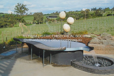
Photograph, Fay Bridge, Garden art, Swipers Gully Restaurant, 25 Eltham-Yarra Glen Rd, Kangaroo Ground, n.d
... Garden art, Swipers Gully Restaurant, 25 Eltham-Yarra Glen Rd, Kangaroo Ground......Eltham-Yarra Glen Rd...Fay Bridge Collection Eltham-Yarra Glen Rd Garden art Kangaroo Ground Eltham College Swiper's Gully 4 images - Scanned from colour prints on loan Garden art, Swipers Gully Restaurant, 25 Eltham-Yarra Glen Rd, Kangaroo Ground Photograph Photograph Fay Bridge ...Owned and operated by Eltham College , Swipers Gully is a Hospitality Training Centre and fully-functional winery, café and restaurant.fay bridge collection, eltham-yarra glen rd, garden art, kangaroo ground, eltham college, swiper's gully -
 Eltham District Historical Society Inc
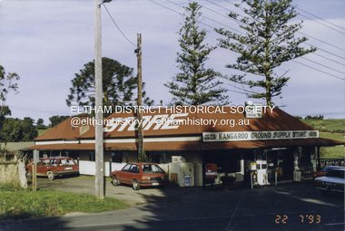
Photograph - Colour Print, Kangaroo Ground Store, 280 Eltham-Yarra Glen Rd, Kangaroo Ground, 22 July 1993
... Kangaroo Ground Store, 280 Eltham-Yarra Glen Rd, Kangaroo Ground...Cornelius Wraight Eltham-Yarra Glen Road General Store Kangaroo Ground Kangaroo Ground Store Kangaroo Ground Supply Store Milk bar Post Office Service Station Colour photo print 10 x 15 cm, originally stuck down on corflute for display Kangaroo Ground Store, 280 Eltham-Yarra Glen Rd, Kangaroo Ground Photograph Colour Print ...Cornelius (Con) and his wife Elizabeth ran the store and post office from about 1904. Their son Donald became involved with the store in the 1930s. A petrol bowser was added in early 1933 and a second in 1937. The Wraights ran the store till the 1940s. Elizabeth died 10 April 1952 and Cornelius May 30, 1954.Colour photo print 10 x 15 cm, originally stuck down on corflute for displaycornelius wraight, eltham-yarra glen road, general store, kangaroo ground, kangaroo ground store, kangaroo ground supply store, milk bar, post office, service station -
 Eltham District Historical Society Inc
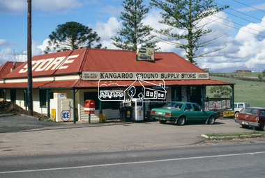
Photograph, Kangaroo Ground Store, 280 Eltham-Yarra Glen Rd, Kangaroo Ground, c.May 1988
... Kangaroo Ground Store, 280 Eltham-Yarra Glen Rd, Kangaroo Ground...Eltham-Yarra Glen Road Kangaroo Ground Kangaroo Ground Store Process Date MAY 88M 35mm colour positive transparency (1 of 25) Mount - Kodak Ektachrome Kangaroo Ground Store, 280 Eltham-Yarra Glen Rd, Kangaroo Ground Photograph Photograph ...35mm colour positive transparency (1 of 25) Mount - Kodak EktachromeProcess Date MAY 88Meltham-yarra glen road, kangaroo ground, kangaroo ground store -
 Eltham District Historical Society Inc
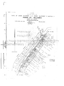
Document - Survey Plan, Country Roads Board, SP 6561, Eltham-Yarra Glen Road; Park Rd to Bellevue Rd, 1957
... SP 6561, Eltham-Yarra Glen Road; Park Rd to Bellevue Rd...Eltham-Yarra Glen Road, Shire of Eltham Shows Surveyor field notes, property ownership and building type and construction. Eltham-Yarra Glen Road Country Roads Board Eltham Main Road Survey Plan 1957 A.R. Thomas B. & B.D. Hearn B.G. Anderson Bellevue Road E.M. Pitts F.A. M. Macrae G.E. & B. Moulder J. Bromley J.M. & S.G. Johnstone K.F. Pitts L.C. Docksey M. & E.C.W. Baart M.P. Bromley N.R. Ord P.J. & G.E. Murphy Park Road R.A. Bruce R.A. Macbeth R.W. Shearing railway road S.E. & Y.P. Houghton W.K. Bell W.S.R. & F.N. Toley Neil Webster Collection A3 print, 2 pages and electronic PDF file SP 6561, Eltham-Yarra Glen Road; Park Rd ...1957 C.R.B. Plan of Survey of Parts of Crown Allotment 1 & Crown Allotment F, Section II Parish of Nillumbik, County of Evelyn Eltham-Yarra Glen Road, Shire of Eltham Shows Surveyor field notes, property ownership and building type and construction.eltham-yarra glen road, country roads board, eltham, main road, survey plan, 1957, a.r. thomas, b. & b.d. hearn, b.g. anderson, bellevue road, e.m. pitts, f.a. m. macrae, g.e. & b. moulder, j. bromley, j.m. & s.g. johnstone, k.f. pitts, l.c. docksey, m. & e.c.w. baart, m.p. bromley, n.r. ord, p.j. & g.e. murphy, park road, r.a. bruce, r.a. macbeth, r.w. shearing, railway road, s.e. & y.p. houghton, w.k. bell, w.s.r. & f.n. toley, neil webster collection -
 Eltham District Historical Society Inc
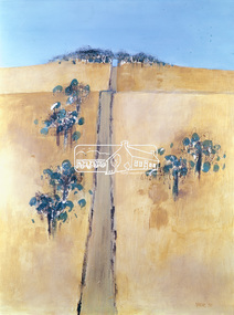
Photograph, "Road to Wattle Glen" - Don Vidler, 1970, 1971
... Don Vidler, Reynolds Rd., Wattle Glen This photo forms part of a collection of photographs gathered by the Shire of Eltham for their centenary project book,"Pioneers and Painters: 100 years of the Shire of Eltham" by Alan Marshall (1971). The collection of over 500 images is held in partnership between Eltham District Historical Society and Yarra ...Reproduced page 125 of Pioneers & Painters, edited by Alan Marshall (1971) Source: Mr. Don Vidler, Reynolds Rd., Wattle GlenThis photo forms part of a collection of photographs gathered by the Shire of Eltham for their centenary project book,"Pioneers and Painters: 100 years of the Shire of Eltham" by Alan Marshall (1971). The collection of over 500 images is held in partnership between Eltham District Historical Society and Yarra Plenty Regional Library (Eltham Library) and is now formally known as the 'The Shire of Eltham Pioneers Photograph Collection.' It is significant in being the first community sourced collection representing the places and people of the Shire's first one hundred years.4 x 5 inch colour reversal film (1) Black and white print 21 x 16 cm Condition: May not be true to colour of original work. Scanned from a 4 x 5 inch colour transparency which was taken c.1970 (approx. 50 years old) and which has undergone significant colour degradation towards the red spectrum. Allowances made for colour cast correction in scan with best guess for white balance. Significant light flare is reflected off glossy surface of original work at camera lens at lower left and right sides causing quality issues. artist, pioneers and painters, sepp, shire of eltham pioneers photograph collection, don vidler -
 Eltham District Historical Society Inc
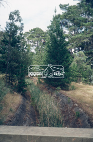
Slide, Maroondah Aqueduct, Research, Victoria, 22 Mar. 1981
... Eltham Historical Society on Sunday, March 22nd, 1981, commening where the aqueduct crosses Main Rd., Research, just below Eltham College. The Maroondah Aqueduct was part of Melbourne’s water supply system. It carried water over the 66 km from the Maroondah Reservoir on the Watts River at Healesville to the Preston Reservoir. Of this length, 41 km were open channel, 10 km, tunnel through hills and 15 km in 14 inverted siphons across stream valleys. The route of the aqueduct is north of Tarrawarra and Yarra Glen...Eltham Historical Society on Sunday, March 22nd, 1981, commening where the aqueduct crosses Main Rd., Research, just below Eltham College. The Maroondah Aqueduct was part of Melbourne’s water supply system. It carried water over the 66 km from the Maroondah Reservoir on the Watts River at Healesville to the Preston Reservoir. Of this length, 41 km were open channel, 10 km, tunnel through hills and 15 km in 14 inverted siphons across stream valleys. The route of the aqueduct is north of Tarrawarra and Yarra Glen ...An inspection tour of the Maroondah Aqueduct was undertaken by the Shire of Eltham Historical Society on Sunday, March 22nd, 1981, commening where the aqueduct crosses Main Rd., Research, just below Eltham College. The Maroondah Aqueduct was part of Melbourne’s water supply system. It carried water over the 66 km from the Maroondah Reservoir on the Watts River at Healesville to the Preston Reservoir. Of this length, 41 km were open channel, 10 km, tunnel through hills and 15 km in 14 inverted siphons across stream valleys. The route of the aqueduct is north of Tarrawarra and Yarra Glen, along the Yarra escarpment south of Christmas Hills and crossing Watsons Creek into the present Shire of Eltham near Henley Rd. The eastern part of the route lies entirely within the former boundaries of the shire. The aqueduct passes south of Kangaroo Ground to Research and crosses the Diamond Creek by siphon at Allendale Rd., Eltham North. It then extends to Reservoir via St. Helena, Greensborough North and Bundoora. Water first flowed through the aqueduct in February 1891 when it was fed by a diversion weir on the Watts River. Records of the building of the aqueduct indicate that it was a significant construction achievement. The present Maroondah Reservoir was completed in 1927 and the aqueduct was enlarged at that time to take increased flows. About 1971 the section of the aqueduct through and north of Research was replaced by a large pipe and that section of the channel is now unused. The channel has remained largely intact (unlike sections at Greensborough and Bundoora where long lengths of the disused aqueduct have been demolished or filled in). The M.M.B.W. relinquished control of the disused aqueduct reserve which is crown land and the Shire of Eltham took control of this section of the reserve as a linear park. The Maroondah Aqueduct is considered to be an important historic structure, not just to the local area but to the metropolitan area generally. It is considered important to preserve substantially intact long lengths of the disused aqueduct, together with its bridges and other associated structures. 35 mm colour positive transparency (1 of 5) Mount - Agfachrome Agfa CS System black 8 dotsactivities, heritage excursion, maroondah aqueduct, research (vic.), shire of eltham historical society -
 Eltham District Historical Society Inc
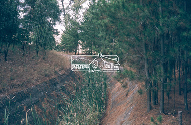
Slide, Maroondah Aqueduct, Research, Victoria, 22 Mar. 1981
... Eltham Historical Society on Sunday, March 22nd, 1981, commening where the aqueduct crosses Main Rd., Research, just below Eltham College. The Maroondah Aqueduct was part of Melbourne’s water supply system. It carried water over the 66 km from the Maroondah Reservoir on the Watts River at Healesville to the Preston Reservoir. Of this length, 41 km were open channel, 10 km, tunnel through hills and 15 km in 14 inverted siphons across stream valleys. The route of the aqueduct is north of Tarrawarra and Yarra Glen...Eltham Historical Society on Sunday, March 22nd, 1981, commening where the aqueduct crosses Main Rd., Research, just below Eltham College. The Maroondah Aqueduct was part of Melbourne’s water supply system. It carried water over the 66 km from the Maroondah Reservoir on the Watts River at Healesville to the Preston Reservoir. Of this length, 41 km were open channel, 10 km, tunnel through hills and 15 km in 14 inverted siphons across stream valleys. The route of the aqueduct is north of Tarrawarra and Yarra Glen ...An inspection tour of the Maroondah Aqueduct was undertaken by the Shire of Eltham Historical Society on Sunday, March 22nd, 1981, commening where the aqueduct crosses Main Rd., Research, just below Eltham College. The Maroondah Aqueduct was part of Melbourne’s water supply system. It carried water over the 66 km from the Maroondah Reservoir on the Watts River at Healesville to the Preston Reservoir. Of this length, 41 km were open channel, 10 km, tunnel through hills and 15 km in 14 inverted siphons across stream valleys. The route of the aqueduct is north of Tarrawarra and Yarra Glen, along the Yarra escarpment south of Christmas Hills and crossing Watsons Creek into the present Shire of Eltham near Henley Rd. The eastern part of the route lies entirely within the former boundaries of the shire. The aqueduct passes south of Kangaroo Ground to Research and crosses the Diamond Creek by siphon at Allendale Rd., Eltham North. It then extends to Reservoir via St. Helena, Greensborough North and Bundoora. Water first flowed through the aqueduct in February 1891 when it was fed by a diversion weir on the Watts River. Records of the building of the aqueduct indicate that it was a significant construction achievement. The present Maroondah Reservoir was completed in 1927 and the aqueduct was enlarged at that time to take increased flows. About 1971 the section of the aqueduct through and north of Research was replaced by a large pipe and that section of the channel is now unused. The channel has remained largely intact (unlike sections at Greensborough and Bundoora where long lengths of the disused aqueduct have been demolished or filled in). The M.M.B.W. relinquished control of the disused aqueduct reserve which is crown land and the Shire of Eltham took control of this section of the reserve as a linear park. The Maroondah Aqueduct is considered to be an important historic structure, not just to the local area but to the metropolitan area generally. It is considered important to preserve substantially intact long lengths of the disused aqueduct, together with its bridges and other associated structures. 35 mm colour positive transparency (1 of 5) Mount - Agfachrome Agfa CS System black 8 dotsactivities, heritage excursion, maroondah aqueduct, research (vic.), shire of eltham historical society -
 Eltham District Historical Society Inc
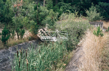
Slide, Maroondah Aqueduct, Research, Victoria, 22 Mar. 1981
... Eltham Historical Society on Sunday, March 22nd, 1981, commening where the aqueduct crosses Main Rd., Research, just below Eltham College. The Maroondah Aqueduct was part of Melbourne’s water supply system. It carried water over the 66 km from the Maroondah Reservoir on the Watts River at Healesville to the Preston Reservoir. Of this length, 41 km were open channel, 10 km, tunnel through hills and 15 km in 14 inverted siphons across stream valleys. The route of the aqueduct is north of Tarrawarra and Yarra Glen...Eltham Historical Society on Sunday, March 22nd, 1981, commening where the aqueduct crosses Main Rd., Research, just below Eltham College. The Maroondah Aqueduct was part of Melbourne’s water supply system. It carried water over the 66 km from the Maroondah Reservoir on the Watts River at Healesville to the Preston Reservoir. Of this length, 41 km were open channel, 10 km, tunnel through hills and 15 km in 14 inverted siphons across stream valleys. The route of the aqueduct is north of Tarrawarra and Yarra Glen ...An inspection tour of the Maroondah Aqueduct was undertaken by the Shire of Eltham Historical Society on Sunday, March 22nd, 1981, commening where the aqueduct crosses Main Rd., Research, just below Eltham College. The Maroondah Aqueduct was part of Melbourne’s water supply system. It carried water over the 66 km from the Maroondah Reservoir on the Watts River at Healesville to the Preston Reservoir. Of this length, 41 km were open channel, 10 km, tunnel through hills and 15 km in 14 inverted siphons across stream valleys. The route of the aqueduct is north of Tarrawarra and Yarra Glen, along the Yarra escarpment south of Christmas Hills and crossing Watsons Creek into the present Shire of Eltham near Henley Rd. The eastern part of the route lies entirely within the former boundaries of the shire. The aqueduct passes south of Kangaroo Ground to Research and crosses the Diamond Creek by siphon at Allendale Rd., Eltham North. It then extends to Reservoir via St. Helena, Greensborough North and Bundoora. Water first flowed through the aqueduct in February 1891 when it was fed by a diversion weir on the Watts River. Records of the building of the aqueduct indicate that it was a significant construction achievement. The present Maroondah Reservoir was completed in 1927 and the aqueduct was enlarged at that time to take increased flows. About 1971 the section of the aqueduct through and north of Research was replaced by a large pipe and that section of the channel is now unused. The channel has remained largely intact (unlike sections at Greensborough and Bundoora where long lengths of the disused aqueduct have been demolished or filled in). The M.M.B.W. relinquished control of the disused aqueduct reserve which is crown land and the Shire of Eltham took control of this section of the reserve as a linear park. The Maroondah Aqueduct is considered to be an important historic structure, not just to the local area but to the metropolitan area generally. It is considered important to preserve substantially intact long lengths of the disused aqueduct, together with its bridges and other associated structures. 35 mm colour positive transparency (1 of 5) Mount - Agfachrome Agfa CS System black 8 dotsactivities, heritage excursion, maroondah aqueduct, research (vic.), shire of eltham historical society -
 Eltham District Historical Society Inc
Slide, Maroondah Aqueduct, Research, Victoria, 22 Mar. 1981
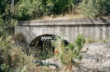
... Eltham Historical Society on Sunday, March 22nd, 1981, commening where the aqueduct crosses Main Rd., Research, just below Eltham College. The Maroondah Aqueduct was part of Melbourne’s water supply system. It carried water over the 66 km from the Maroondah Reservoir on the Watts River at Healesville to the Preston Reservoir. Of this length, 41 km were open channel, 10 km, tunnel through hills and 15 km in 14 inverted siphons across stream valleys. The route of the aqueduct is north of Tarrawarra and Yarra Glen...Eltham Historical Society on Sunday, March 22nd, 1981, commening where the aqueduct crosses Main Rd., Research, just below Eltham College. The Maroondah Aqueduct was part of Melbourne’s water supply system. It carried water over the 66 km from the Maroondah Reservoir on the Watts River at Healesville to the Preston Reservoir. Of this length, 41 km were open channel, 10 km, tunnel through hills and 15 km in 14 inverted siphons across stream valleys. The route of the aqueduct is north of Tarrawarra and Yarra Glen ...An inspection tour of the Maroondah Aqueduct was undertaken by the Shire of Eltham Historical Society on Sunday, March 22nd, 1981, commening where the aqueduct crosses Main Rd., Research, just below Eltham College. The Maroondah Aqueduct was part of Melbourne’s water supply system. It carried water over the 66 km from the Maroondah Reservoir on the Watts River at Healesville to the Preston Reservoir. Of this length, 41 km were open channel, 10 km, tunnel through hills and 15 km in 14 inverted siphons across stream valleys. The route of the aqueduct is north of Tarrawarra and Yarra Glen, along the Yarra escarpment south of Christmas Hills and crossing Watsons Creek into the present Shire of Eltham near Henley Rd. The eastern part of the route lies entirely within the former boundaries of the shire. The aqueduct passes south of Kangaroo Ground to Research and crosses the Diamond Creek by siphon at Allendale Rd., Eltham North. It then extends to Reservoir via St. Helena, Greensborough North and Bundoora. Water first flowed through the aqueduct in February 1891 when it was fed by a diversion weir on the Watts River. Records of the building of the aqueduct indicate that it was a significant construction achievement. The present Maroondah Reservoir was completed in 1927 and the aqueduct was enlarged at that time to take increased flows. About 1971 the section of the aqueduct through and north of Research was replaced by a large pipe and that section of the channel is now unused. The channel has remained largely intact (unlike sections at Greensborough and Bundoora where long lengths of the disused aqueduct have been demolished or filled in). The M.M.B.W. relinquished control of the disused aqueduct reserve which is crown land and the Shire of Eltham took control of this section of the reserve as a linear park. The Maroondah Aqueduct is considered to be an important historic structure, not just to the local area but to the metropolitan area generally. It is considered important to preserve substantially intact long lengths of the disused aqueduct, together with its bridges and other associated structures. 35 mm colour positive transparency (1 of 5) Mount - Agfachrome Agfa CS System black 8 dotsactivities, heritage excursion, maroondah aqueduct, research (vic.), shire of eltham historical society -
 Eltham District Historical Society Inc
Photograph, Post Office, Christmas Hills
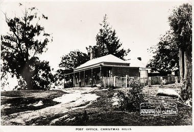
... The site of the Post office was the south side of Eltham on the Yarra Glen road. 0.3 km SW of Ridge Rd., now freehold. ...The site of the Post office was the south side of Eltham on the Yarra Glen road. 0.3 km SW of Ridge Rd., now freehold. ...The site of the Post office was the south side of Eltham on the Yarra Glen road. 0.3 km SW of Ridge Rd., now freehold. The first Post Office-cum General Store at Christmas Hills was built by Thomas Young during the 1870s, when the district was a thriving farming community. Young operated postal services here from 1874 to 1909. Moreover, the two front rooms of this general store aslo served as the district's first school. When the store was demolished in the early 1900s, these school-rooms were moved to the residence next door (to the east) which took over the role of the Post Office store until the service finally closed in the early 1970s. The latter building is still in use today as a private residence". Christmas Hills Past & Present (Yarra Glen & District Historical Society, 2004)Roll of medium format 120 6x6 black and white negative film, 4 framesAgfa APX 100shire of eltham pioneers photograph collection, sepp, christmas hills, post office -
 Eltham District Historical Society Inc
Photograph - Aerial Photograph, Landata, Eltham, Main Rd; Railway Rd to Zig Zag Rd, Dec. 1945
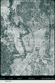
... Centred on present day Edendale Farm from Glen Park rd to Zig Zag Rd Historic Aerial Imagery Source: Landata.vic.gov.au Aerial Photo Details: Project No :5 Project : MELBOURNE AND METROPOLITAN AREA PROJECT Run : 37 Frame : 60549 Date : 12/1945 Film Type : B/W Camera : EAG4 Flying Height : 10200 Scale : 6000 Film Number : 196 GDA2020 : 37°42'12"S, 145°09'09"E MGA2020 : 337141, 5825486 (55) Melways : 21 K2 (ed. 42) Aerial Photo Eltham Edendale Farm eltham - yarra glen road Eltham-Hurstbridge Railway line Gastons Homestead Gastons Road Glen Park Road Main Road Park Road railway road Wattletree Road Zig Zag Road Neil Webster Collection A3 photo print and electronic PDF file Eltham, Main Rd; Railway Rd to Zig Zag Rd Photograph Aerial Photograph Landata ...Centred on present day Edendale Farm from Glen Park rd to Zig Zag Rd Historic Aerial Imagery Source: Landata.vic.gov.au Aerial Photo Details: Project No :5 Project : MELBOURNE AND METROPOLITAN AREA PROJECT Run : 37 Frame : 60549 Date : 12/1945 Film Type : B/W Camera : EAG4 Flying Height : 10200 Scale : 6000 Film Number : 196 GDA2020 : 37°42'12"S, 145°09'09"E MGA2020 : 337141, 5825486 (55) Melways : 21 K2 (ed. 42)aerial photo, eltham, edendale farm, eltham - yarra glen road, eltham-hurstbridge railway line, gastons homestead, gastons road, glen park road, main road, park road, railway road, wattletree road, zig zag road, neil webster collection -
 Eltham District Historical Society Inc
Photograph - Aerial Photograph, Landata, Eltham, Main Road; Mt Pleasant Rd to Railway Rd, Dec. 1945
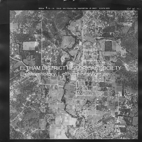
... Historic Aerial Imagery Source: Landata.vic.gov.au Aerial Photo Details: Project No :65 Project : MELBOURNE AND METROPOLITAN PROJECT NO. 2 Run : 8 Frame : 70 Date : 01/1951 Film Type : B/W Camera : EAG9 Flying Height : 12200 Scale : 12000 Film Number : 1419 GDA2020 : 37°43'06"S, 145°08'45"E MGA2020 : 336589, 5823811 (55) Melways : 21 J6 (ed. 42) Aerial Photo Eltham Main Road Henry Street Arthur Street Bolton Street Eltham-Yarra Glen Road Neil Webster Collection 1951-01 Dave Lyon House Ernie Andrew house Karingal Road Melway 21J6 Mount Pleasant Road railway road A3 photo print and electronic PDF file Eltham, Main Road; Mt Pleasant Rd to Railway Rd Photograph Aerial Photograph Landata ...Centred on Main Rd and Henry St, Eltham bounded by Railway Road to north, Mount Pleasant Road at Main Road to south, top of the hill in Arthur Street to east and Karingal Drive at Sherbourne Road to west. Historic Aerial Imagery Source: Landata.vic.gov.au Aerial Photo Details: Project No :65 Project : MELBOURNE AND METROPOLITAN PROJECT NO. 2 Run : 8 Frame : 70 Date : 01/1951 Film Type : B/W Camera : EAG9 Flying Height : 12200 Scale : 12000 Film Number : 1419 GDA2020 : 37°43'06"S, 145°08'45"E MGA2020 : 336589, 5823811 (55) Melways : 21 J6 (ed. 42)aerial photo, eltham, main road, henry street, arthur street, bolton street, eltham-yarra glen road, neil webster collection, 1951-01, dave lyon house, ernie andrew house, karingal road, melway 21j6, mount pleasant road, railway road
