Showing 256 items matching "farm view"
-
 University of Melbourne, Burnley Campus Archives
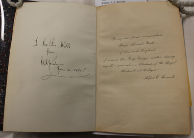
Photograph - Black and white prints and negatives, A.E. Bennett, A.E. Bennett Prize Essays, 1893-1894
... ...farm view...(v) Pioneer timber cottage man and children. (vi) Farm view. (vii) "School of Mines Maryborough. ...(v) Pioneer timber cottage man and children. (vi) Farm view. (vii) "School of Mines Maryborough. ...Alfred E. Bennett was one of the first students to graduate with a Diploma. He wrote the book after he graduated in 1894. (1) Photographs of photographs, etc. in A.E. Bennett book, "Prize Essays." (i) Acknowledgement for photographs. (ii) p. 101 Appendix. (iii) Diseases of. (iv) Apples. (v) Pioneer timber cottage man and children. (vi) Farm view. (vii) "School of Mines Maryborough. (viii) Group Staff and Students. (ix) "Railway Station Maryborough." (x) "High Street Maryborough." (xi) Maryborough. (xii) Church, Maryborough. (xiii) Maryborough? (xiv) Students and staff seated on horse-drawn cart. (xv, xvi) Distillery equipment. (2) 2 sets of proofs of all photographs in the book. (3) Negatives. Probably taken by A.P. Winzenried for "Green Grows Our Garden." (GGOG). Images used for Media are from B25.0005 as they are the complete collection. Photographs used in GGOG: 26. p9, 11. p10, 25. p12, 5. p22, 19. p29, 15. p32, 27. p 21. The original book is stored with the Burnley Rare Book Collection at the Baillieu Librarya.e. bennett, prize essay, diseases, apples, timber cottage, farm view, school of mines, maryborough, staff, students, railway station, maryborough, church, horse-drawn cart, distillery equipment, a.p. winzenried, green grows our garden, students working outside, orchard, spraying equipment, pruning, planting, orchard gates, entrance gates, neilsons cottage, principal's residence, horticultural board of advice, pavilion, wheelbarrows, californian redwood, sequoia sempervirens, excursion -
 Phillip Island and District Historical Society Inc.
Photograph
... ...farm machinery...view...Jack Jenner (1977) local history photography photographs slides film rural industry farm machinery view cowes black & white photograph jack jenner farm dray mcillwraith family phillip island Labelled: Original Farm Dray in which McIlwraith Family came to Phillip Island in January 1869. ...Part of collection of Photographs donated to the Museum by the family of the late Mr. Jack Jenner (1977)Black & White Photograph of an Original Farm DrayLabelled: Original Farm Dray in which McIlwraith Family came to Phillip Island in January 1869.local history, photography, photographs, slides, film rural industry, farm machinery, view cowes, black & white photograph, jack jenner, farm dray, mcillwraith family, phillip island -
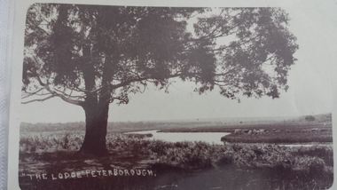 Peterborough History Group
Postcard - The Lodge Postcard
... farm...curdies river - view...Historic and social significance james irivine the lodge farm curdies river - view curdies river peterborough curdies river vintage postcards Hand written letter on the back "To Cora, from Auntie May" Postcards depicting the Curdies River at The Lodge. ...Historic picture of the Curdies River, with reference to the farm known as The Lodge. the Lodge is also the name given to the good fishing spot on the banks of the Curdies which is accessed by a track through farmland.Historic and social significancePostcards depicting the Curdies River at The Lodge.Hand written letter on the back "To Cora, from Auntie May"james irivine, the lodge farm, curdies river - view, curdies river peterborough, curdies river, vintage postcards -
 Narre Warren and District Family History Group
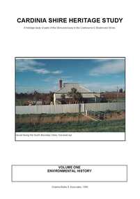
Book, Graeme Butler & Associates, Cardinia Shire Heritage Study : a heritage study of parts of the Shire previously in the Cranbourne & Sherbrooke Shires. Vol 1 : Key Findings and Recommendations Vol 2 : Heritage Place and Precinct Citations, 1998
... Farm Complex...Emerald Lake Park...The Grange (Koo Wee Rup)...Glen Afton (Yannathan)...Myrtlewood (Yannathan)...Vay View...Cardinia Shire (Vic.) heritage studies Tivoli Berry Farm (Clematis) Carramar (Emerald) Nobelius Heritage Park Dalmore Public Hall Horace Hardy Farm Complex Emerald Lake Park The Grange (Koo Wee Rup) Glen Afton (Yannathan) Myrtlewood (Yannathan) Vay View Farm (Lang Lang) Emerald Railway Station Timber Bridges (Yallock Creek) Emerald County Clud Oak Lee (Emerald) Sycamore Lodge (Emerald) Cambden Wollybutt Row (Emerald) Silver Birches (Emerald) Lang Lang Cemetery Old Monomeith Homestead sites Monomeith Park (Monomeith) Dustings Garage (Koo Wee Rup) Koo Wee Rup Public Hall Koo Wee Rup Lockup Wattle Theatre (Koo Wee Rup) Harewood (Koo Wee Rup) Warook Homestead (Monomeith) Old Yallock St John's Roman Catholic Church (Koo Wee Rup) Royal Hotel (Koo Wee Rup) Budgeree (Yannathan) Cascades Guest House (Clematis) Rutter Farm (Tooradin) Koo Wee Rup Swamp Drains Upper Ferntree Gully to Gembrook Railway Great Southern Railway Misson's Butchers Shop & Residence (Lang Lang) English Scottish & Australian Bank (Lang Lang) Clematis Park Row Houses (Lang Lang) This Environmental History of the Cardinia Shire incorporates the Environmental History of the former Shire of Pakenham, compiled by Carlotta Kellaway for Graeme Butler & Associates and the Environmental History of those areas of the Shire formerly in the Shires of Cranbourne and Sherbrooke, compiled by Jill Barnard for Graeme Butler and Associates. ...This Environmental History of the Cardinia Shire incorporates the Environmental History of the former Shire of Pakenham, compiled by Carlotta Kellaway for Graeme Butler & Associates and the Environmental History of those areas of the Shire formerly in the Shires of Cranbourne and Sherbrooke, compiled by Jill Barnard for Graeme Butler and Associates. An environmental history, which is meant as a guide to the identification of sites of significance within a shire, cannot be a complete social history of that shire. Rather, it is meant to be a summary of the various ways in which people have used and reacted to the natural environment, altering it so as to create economic, social, cultural and educational uses for themselves and their neighbours. [from the introduction]non-fictionThis Environmental History of the Cardinia Shire incorporates the Environmental History of the former Shire of Pakenham, compiled by Carlotta Kellaway for Graeme Butler & Associates and the Environmental History of those areas of the Shire formerly in the Shires of Cranbourne and Sherbrooke, compiled by Jill Barnard for Graeme Butler and Associates. An environmental history, which is meant as a guide to the identification of sites of significance within a shire, cannot be a complete social history of that shire. Rather, it is meant to be a summary of the various ways in which people have used and reacted to the natural environment, altering it so as to create economic, social, cultural and educational uses for themselves and their neighbours. [from the introduction] cardinia shire (vic.), heritage studies, tivoli berry farm (clematis), carramar (emerald), nobelius heritage park, dalmore public hall, horace hardy farm complex, emerald lake park, the grange (koo wee rup), glen afton (yannathan), myrtlewood (yannathan), vay view farm (lang lang), emerald railway station, timber bridges (yallock creek), emerald county clud, oak lee (emerald), sycamore lodge (emerald), cambden wollybutt row (emerald), silver birches (emerald), lang lang cemetery, old monomeith homestead sites, monomeith park (monomeith), dustings garage (koo wee rup), koo wee rup public hall, koo wee rup lockup, wattle theatre (koo wee rup), harewood (koo wee rup), warook homestead (monomeith), old yallock, st john's roman catholic church (koo wee rup), royal hotel (koo wee rup), budgeree (yannathan), cascades guest house (clematis), rutter farm (tooradin), koo wee rup swamp drains, upper ferntree gully to gembrook railway, great southern railway, misson's butchers shop & residence (lang lang), english scottish & australian bank (lang lang), clematis park, row houses (lang lang) -
Bendigo Historical Society Inc.
Document - DOUGLAS FAMILY TREE 1843 - 1981, 1843 - 1981
... They settled at View Hill farm in Woodstock West where they had the following family:- ...James was the original selector of View Hill Farm which remains in Douglas ownership. ...James was the original selector of View Hill Farm which remains in Douglas ownership. ...James Crawford Douglas was born in Ireland in 1842. He came to Australia in 1864 and married Mary Michael (1849-1921) in 1868. They settled at View Hill farm in Woodstock West where they had the following family:- Family tree records descendants of James and Mary Douglas. James was the original selector of View Hill Farm which remains in Douglas ownership. Refer to book 5086 in Library Box 5 'Douglas: A Family History 1845 - 1981'bendigo, history, pioneers -
Port Melbourne Historical & Preservation Society
Photograph - COR/BP tank farm clean-up, Alison Kelly, Aug 1990
... Four colour photos of bulldozer working on clean up process on site of former COR/BP tank farm - view to south. Archivally mounted on vertical strip of white card and enclosed in mylar. ...Kelly 645 2324' Four colour photos of bulldozer working on clean up process on site of former COR/BP tank farm - view to south. Archivally mounted on vertical strip of white card and enclosed in mylar. ...Shot when Alision Kelly was caretaker at the nearby 'Mission Art Centre' and displayed there and at the Port Melbourne LibraryFour colour photos of bulldozer working on clean up process on site of former COR/BP tank farm - view to south. Archivally mounted on vertical strip of white card and enclosed in mylar. Photos all looking south; views of equipment scooping out hydro-carbons, soil from pit filled with ground water; top to bottom: Williamstown and Webb Dock in background; white Toyota EAY-921 right foreground; close up; close up; Princes Pier in left backgroundInk on back: 'A. Kelly 645 2324'town planning - proposals shelved - bayside, environment, alison kelly -
 Ballarat Heritage Services
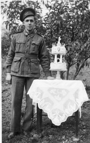
Photograph - Photograph - Black and White, Vince Gervasoni and his 21st birthday cake
... The photograph was taken in the back yard of his famile's Yandoit Creek farm 'Pine View'. ...The photograph was taken in the back yard of his famile's Yandoit Creek farm 'Pine View'. Vince Gervasoni and his 21st birthday cake Photograph Photograph - Black and White ...Vince was the youngest son of John and Catherine Gervasoni, and the grandson of Luigi Gervasoni. Black and white photograph of Vince Gervasoni in World War 2 AIF uniform, standing next to his 2 tier 21st birthday cake. The photograph was taken in the back yard of his famile's Yandoit Creek farm 'Pine View'. yandoit creek, vince gervasoni, birthday cake, world war 2 -
 Greensborough Historical Society
Photograph (copy), Fred Kruger, On the Plenty River near Bundoora / photograph by Fred Kruger, 1877c
... View of farm land and mill on the Plenty River near Bundoora, circa 1877; photograph by Fred Kruger. ...Greensborough Historical Society 34A Glenauburn Road Lower Plenty Lower Plenty melbourne View of farm land and mill on the Plenty River near Bundoora, circa 1877; photograph by Fred Kruger. ...View of farm land and mill on the Plenty River near Bundoora, circa 1877; photograph by Fred Kruger. Original held at SLV (accession # H473 and Image # a53840)Black and white photograph, enlarged and laminated.fred kruger, plenty river -
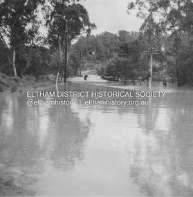 Eltham District Historical Society Inc
Album - Photograph, J.A. McDonald, Eltham-Diamond Creek Road, 21 Oct. 1953
... view is Mrs Lucy Egan's home. That house still stands today nestled up against the Wattletree Road Bridge on the other side built in 1959 and is owned by the Bakos family purchased by Mrs Heather Bakos in 1960.. Prior to the Wattletree Road bridge being built, Railway Parade extended up the alignment of present-day Gastons Road to the Eltham-Diamond Creek road which ran past the entrance of the present-day carpark for Edendale Farm. ...view is Mrs Lucy Egan's home. That house still stands today nestled up against the Wattletree Road Bridge on the other side built in 1959 and is owned by the Bakos family purchased by Mrs Heather Bakos in 1960.. Prior to the Wattletree Road bridge being built, Railway Parade extended up the alignment of present-day Gastons Road to the Eltham-Diamond Creek road which ran past the entrance of the present-day carpark for Edendale Farm. ...18 October 1956 Flood level on road at corner of Railway Parade. On the immediate left out of view is Mrs Lucy Egan's home. That house still stands today nestled up against the Wattletree Road Bridge on the other side built in 1959 and is owned by the Bakos family purchased by Mrs Heather Bakos in 1960.. Prior to the Wattletree Road bridge being built, Railway Parade extended up the alignment of present-day Gastons Road to the Eltham-Diamond Creek road which ran past the entrance of the present-day carpark for Edendale Farm. This view is looking west across the Glen Park Bridge, and the beginning of Wattletree Road which sweeps around to the right in the distance. Progress Road does not exist though a road reserve is present on maps.Record of various Shire of Eltham infrastructure works undertaken during the period of 1952-1962 involving bridge and road reconstruction projects, sometimes with Eltham Shire Council Project Reference numbers quoted. It was during this period that a number of significant improvements were made to roads and new bridges constructed within the shire that remain in place as of present day (2022). In many situations, the photos provide a tangible visible record of infrastructure that existed throughout the early days of the Shire. The album was put together by or under the direction of the Shire Engineer, J.A. McDonald.infrastructure, road construction, shire of eltham, bridge construction, eltham north, floods, floodwater, glen park bridge, 1956-10-18, diamond creek (creek), eltham, railway parade, wattletree road, wattletree road bridge, gastons road -
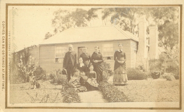
 Bacchus Marsh & District Historical Society
Photograph, Cameron family at Glen Head property near Bacchus Marsh 1883
... After working as a shepherd for sometime Malcolm Cameron was able to acquire land for a farm a few kilometers north west of Bacchus Marsh. The farm was called Glen View but this was later changed to Grand View. ...After working as a shepherd for sometime Malcolm Cameron was able to acquire land for a farm a few kilometers north west of Bacchus Marsh. The farm was called Glen View but this was later changed to Grand View. ...Malcolm Cameron, came from Scotland to Australia with his wife in 1862. From late 1862 they lived in Bacchus Marsh and remained there for the rest of their lives. After working as a shepherd for sometime Malcolm Cameron was able to acquire land for a farm a few kilometers north west of Bacchus Marsh. The farm was called Glen View but this was later changed to Grand View. It is known to have been a wheat farm, Malcolm Cameron died aged 89 in 1922. His wife died in 1926. Small sepia unframed photograph on card with gold border framing photograph. Housed in the album, 'Photographs of Bacchus Marsh and District in 1883 by Stevenson and McNicoll'. The image shows a family group, the Cameron family of Bacchus Marsh, standing and sitting in a paddock on their farm. Cows graze in the paddock nearby. In the background, in the distance, can be seen the Cameron family home.On the front: Stevenson & McNicoll. Photo. 108 Elizabeth St. Melbourne. COPIES CAN BE OBTAINED AT ANY TIME. On the back: LIGHT & TRUTH inscribed on a banner surmounted by a representation of the rising sun. Copies of this Portrait can be had at any time by sending the Name and Post Office Money Order or Stamps for the amount of order to STEVENSON & McNICOLL LATE BENSON & STEVENSON, Photographers. 108 Elizabeth Street, MELBOURNE. stevenson and mcnicoll 1883 photographs of bacchus marsh and district, farmers, farms, wheat farms, cameron family bacchus marsh -
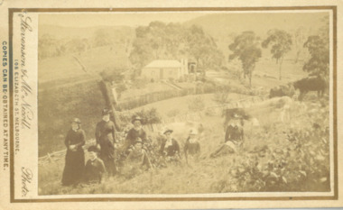
 Bacchus Marsh & District Historical Society
Photograph, Cameron family at Glen Head farm house near Bacchus Marsh 1883
... After working as a shepherd for some time, Malcolm Cameron was able to acquire land for a farm a few kilometres north west of Bacchus Marsh. The farm was called Glen View but this was later changed to Grand View. ...After working as a shepherd for some time, Malcolm Cameron was able to acquire land for a farm a few kilometres north west of Bacchus Marsh. The farm was called Glen View but this was later changed to Grand View. ...Malcolm Cameron, came from Scotland to Australia with his wife Isabella in 1862. From late 1862 they lived in Bacchus Marsh and remained there for the rest of their lives. After working as a shepherd for some time, Malcolm Cameron was able to acquire land for a farm a few kilometres north west of Bacchus Marsh. The farm was called Glen View but this was later changed to Grand View. It is known to have been a wheat farm. Malcolm Cameron died aged 89 in 1922. His wife died in 1926. Mrs Cameron is presumed to be the woman seated in the photograph and the younger people the Cameron children, Catherine (b.1863), Marion (b.1864)), Mary (b.1867), John (b.1870) and Isabella (b.1872). Small sepia unframed photograph on card with gold border framing photograph. Housed in the album, 'Photographs of Bacchus Marsh and District in 1883 by Stevenson and McNicoll'. The image shows a family group, the Cameron family of Bacchus Marsh, standing and sitting in the garden in front of their farm house. The group comprises four women, a girl, a boy and an elderly man, who is presumed to be Malcolm Cameron. The woman seated in the middle of the group is likely to be Mrs.Cameron. To the left in the picture is a dog. In the background is the weatherboard farm house, a simple construction with two large chimneys and a skillion extension.On the front: Stevenson & McNicoll. Photo. 108 Elizabeth St. Melbourne. COPIES CAN BE OBTAINED AT ANY TIME. On the back: LIGHT & TRUTH inscribed on a banner surmounted by a representation of the rising sun. Copies of this Portrait can be had at any time by sending the Name and Post Office Money Order or Stamps for the amount of order to STEVENSON & McNICOLL LATE BENSON & STEVENSON, Photographers. 108 Elizabeth Street, MELBOURNE. stevenson and mcnicoll 1883 photographs of bacchus marsh and district, farmers, farms, wheat farms, cameron family bacchus marsh -
 Kiewa Valley Historical Society
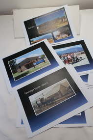
Coloured photographs on paper - Back to Tawonga 2010
... Harry Cooper's Farm Looking South 25.View from Edmondson's Farm - looking north 26. ...Harry Cooper's Farm Looking South 25.View from Edmondson's Farm - looking north 26. ...These photos were collected and copied by Di Edmondson for the 'Back To Tawonga' Event in 2010 when she launched her book "Tawonga Remembers".An historical photographic collection of Tawonga and its surrounds, places and people up to 20101. Saw Mill - Mill house 2. The Rock Pool 3. People at the Rock Pool x 2 4.Old Saw mill 5. Back to Tawonga Celebrations x6 6. Tennis Curts opposite the Tawonga Store, Bakery in the background 7. Bowling Club 8. Old Guide Hall 9. The Old Boarding House 10. Old Fire Brigade Shed 11. Building the New Tawonga Memorial Hall 12. Tawonga Go Kart Track - 1960s 13. Tawonga Pony Club 1969 State Championships 14. Tawonga Recreation Reserve Newspaper article 15. The Damm Children 19. 1980s Brian Edmondson, Geoff Edmondson, Mick Harvey, David Piera. Geoff Edmondson's car 20. Tawonga Speedway Track - 1970s Mick Harvey and Paul Harkin's car 21. 2000 22. Tawonga Sports Vera Ryder and Allie Briggs 23. Tawonga School Photos x8 24. Harry Cooper's Farm Looking South 25.View from Edmondson's Farm - looking north 26. Mount Emu 27. St Aiden's Debutante Ball 27. Grand Opening Ball 1961 Tawonga Hall 28. The Kiewa Valley Road at Tawonga. Vic. 29. Tennis Courts opposite the Bogong Hotel 30.Opening of the new Toilet Block in Pioneer park 31. Old Tawonga Store x 3 32. Tawonga Memorial Hall 33. Anglican Church, St Aiden's x 2 34. Motor Khana held at Recreation reserve 35. 1970 State Champioships Team 36. Kiewa Valley School Sports at Dederang 37. Miscellaneous photos x27 Some photos have headings and some headings have been writtentawonga remembers, back to tawonga 2010, di edmondson -
 Eltham District Historical Society Inc
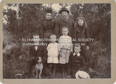
Photograph, Nicholes Photographers, Bird family, c.1905
... Around 1880 or possibly earlier he acquired the property known as View Hill at the top of Pitt Street, Eltham between Pitt Street and Mount Pleasant Road and what is now Eucalyptus Road. George and Janet developed an orchard and farm around the View Hill home and had 10 children, three of whom died young. ...Around 1880 or possibly earlier he acquired the property known as View Hill at the top of Pitt Street, Eltham between Pitt Street and Mount Pleasant Road and what is now Eucalyptus Road. George and Janet developed an orchard and farm around the View Hill home and had 10 children, three of whom died young. ...Bird family, c.1905 Back row, L-R: Janet Bird (nee Kilpatrick), George Bird, Ellen May (Nell) Bird Front row L-R: George Hugh Bird, Ernest Reginald Bird, Arthur Andrew Bird, Edwin John Bird Nicholes Photographer, Alphington According to the Sands McDougall Melbourne Directory, George. Nicholes, Photographer was first listed on the north side of Heidelberg Road, Alphington in 1904 and again in 1905. By 1906 he was still listed but with no profession. From 1907 on he was listed as a bicycle agent. On July 23, 1878, George Bird married Janet Kilpatrick (born Ayrshire) at Northcote by Presbyterian minister, Duncan Fraser. The witnesses were daughters of the minister. George gave his profession as farmer. Around 1880 or possibly earlier he acquired the property known as View Hill at the top of Pitt Street, Eltham between Pitt Street and Mount Pleasant Road and what is now Eucalyptus Road. George and Janet developed an orchard and farm around the View Hill home and had 10 children, three of whom died young. George Bird is listed in the 1977 history of the Eltham Methodist Church as Steward and trustee in the early years. In the 1950 history he is mentioned as Sunday School Superintendent. In the early 1900s, Janet regularly went to the church by horse and jinker. Janet died September 2, 1915, age 60 of endocarditis and bronchial pneumonia. At about this time, three children had married (Sarah, George and Ada) and four were living at home. However, Edwin joined the AIF in August 1915 and Ellen married in 1916 leaving two sons, Arthur and Reg, to look after their father and the property although some of the married children may have lived at View Hill for some time. From Edwin's letters, Hilda Pepper, a cousin on their mother's side) stayed with the family for some time to help. In later years, George developed glaucoma and became blind. He died December 6, 1920, aged 75 years, of diabetes mellites. Both Janet and George are buried at Eltham Cemetery, but the gravestone incorrectly gives 1921 for the death of George. The estate was divided into equal portions and distributed to the surviving members with Arthur and Ted Pepper being Executors. Ada Janet Lowe received a portion above what is now Rockliffe Street and Sis Pepper (Sarah Ann nee Bird) the portion below Rockliffe Street. Ernest Pepper built in the 1930s on the Pepper block at the Pitt Street end. George's share was along Wattle Grove and Arthur received the portion at the eastern end. Presumably the other two received portions including the top of the hill and slopes down to Pitt Street, Mount Pleasant Road and Wattle Grove. Read's (at the corner of Pitt Street and View Hill Crescent) was the first additional house brought in on wheels by a Mr Walkenden. The View Hill house was occupied by the Johanssons in the 1930s and was later damaged by fire. Source: Info provided to Marg Ball by Neil and Lyn Pepper (both deceased) abt. 2018. PANEL 1875-1920 Panels began to be produced around 1875, and were particularly suited, because of their larger size, for capturing family, or even larger, groups. They measured 8.5 by 6.5 inches (22 cm x 16.5 cm). - Frost, Lenore; Dating Family Photos 1850-1920; Valiant Press Pty. Ltd., Berwick, Victoria 1991marg ball collection, 1905, arthur andrew bird, bird family, edwin john bird, ellen may (nell) bird, ernest reginald bird, george bird (1845-1921), george hugh bird, janet bird (nee kilpatrick), nicholes photographer alphington, straw boater -
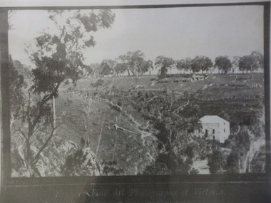
 Warrnambool and District Historical Society Inc.
Album - Farm & Bush views, Late 19th century or early 20th century
... Contains photographs mounted on heavy card. Album Farm & Bush views ...This album contains a number of photos taken around the Otways. They depict a number of people with horses, buggies and tents along bush tracks. There are scenes of Lochard Gorge and the Curdies River at Peterborough, as well as farming scenes. The Otway Ranges was a popular place for day trips and small holidays for the people of the district. Warrnambool and District Historical Society has albums from the Swinton family which depict similar scenes. Dress of the people in the photos would indicate that this trip occurred around the turn of the 20th century. This album has artistic and aesthetic significance as the photos contained within this album are quite beautiful. It also has historical and social significance as it is depicts a typical activity of the time. Brown cover with black floral pattern on front. Back cover is plain. Rectangular in shape. Contains photographs mounted on heavy card.warrnambool, album, photo album, otway ranges, the otways, loch ard gorge,, warrnambool photographs of the past, warrnambool photos -
 Warrnambool and District Historical Society Inc.
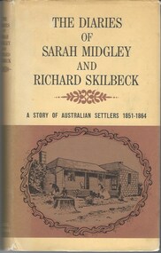
Book, The Diaries of Sarah Midgley and Richard Skilbeck, 1967
... The diaries relate the story of their work on the farm travels through the district and in their local Wesleyan church and social life. This book provides a detailed and first- hand view of early pioneering life. ...Pioneer diaries of early Australian settlers, Sarah Midgley and Richard Skilbeck.Tan hard covered book with tan and yellow dust jacket. Title and text is black. Front cover has framed drawing of cottage taken from photograph which is included in the book. Map of area is on inside front and back covers.208 pages. It has a number of black and white photographic plates included.non-fictionPioneer diaries of early Australian settlers, Sarah Midgley and Richard Skilbeck.sarah midgley, richard skilbeck, diaries of sarah midgley and richard skilbeck, yangery, early pioneer life, wesleyan church warrnambool, yangery koroit -
 Bendigo Military Museum
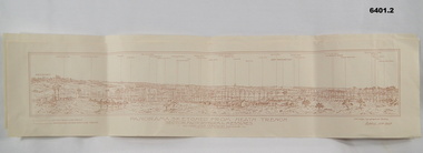
Map - Panorama sketch from Heath Trench Sector Factory Farm to Messines, 11 April 1917
... view of Messines. Printed on cream card. Sepia image. By George W Bleach A 2nd Anzac Topographical Section. April 11th 1917. Panorama sketch from Heath Trench Sector Factory Farm to Messines Map Panorama sketch from Heath Trench Sector Factory Farm to Messines ...Panoramic sketch by George W Bleach A 2nd Anzac Topographical Section. April 11th 1917. View from Heath Trench. Co-ords of O.P.U13.b 30.20Panoramic view of Messines. Printed on cream card. Sepia image. By George W Bleach A 2nd Anzac Topographical Section. April 11th 1917. George W Bleach A 2nd Anzac Topographical Section. April 11th 1917.panoramic view of messines -
 Bendigo Military Museum
Postcard - POSTCARD BOOKLET, PHOTOGRAPHIC, 1910-1919
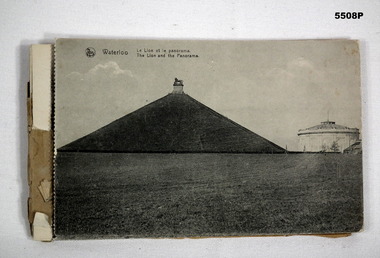
... Farm Papelottre, The Belle Alliance Building. Postcards Battle of Waterloo On the back of photo 1 & 2 is written the letter from J. Burns to his Mum. Dated Bouffioul - Belgium. 3-3-19. Dear Mum, These are a few views ...The images of the Battle scene are; the Lion Mound, Waterloo, The Three Monuments, French Monument, Farm La Haye Sainte, The Prussian Monument, Hougament farm, The Lion, Farm Papelottre, The Belle Alliance Building.This is a bound booklet of Black and White images of the Battle of Waterloo area. On the photos is the caption in French and English. The front cover is missing. Some of the postcards are detached on the "dotted edge". The first two cards have a letter written in pencil from soldier J. Burns to his mum.On the back of photo 1 & 2 is written the letter from J. Burns to his Mum. Dated Bouffioul - Belgium. 3-3-19. Dear Mum, These are a few views of Waterloo, we went right up to the top of this place. This is where all the dead soldiers were buried, so they built this big mound it. It is a good walk to get to the top. - This is where all the battle was, around these ....... Well Mum I am ok again, this is a little souvenir. I can say I have been on the Fields of Waterloo. Well Mum I received another parcel from........? today and it was good too. I will write a letter later so Good Bye Dear Mum for the present, from your loving son James. On the rear post card, written in pencil is: - No.60893 Pte J Burns, 5th Battalion A.I.F. France.postcards, battle of waterloo -
 Kiewa Valley Historical Society
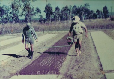
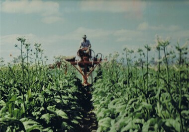
Photograph Tobacco planting, Planting Tobacco seeding, Circa mid to late 1900's
... The remnants of the Tobacco Industry can still be viewed throughout the Kiewa Valley and adjacent regions on the former tobacco farms which still have the tobacco drying sheds and now converted into hay sheds. ...This promotional photograph by the Tobacco Growers Association was in response to a 1935 meeting of tobacco growers from Victoria, South Australia and Queensland which produced four major resolutions for the industry covering the remainder of the 1900s. These four resolutions were: (1) Adequate tariff protection (2) Control of pests and diseases (3) Orderly marketing (4) The formation of an advisory council of growers. History has produced the following results. (1) adequate tariff protection was never achieved,(2) control of disease through benzol vapour (CSIRO) breakthrough, was later identified as carcinogenic, (3) orderly marketing was achieved through (4) the establishment of the Tobacco Growers Association(1984). In October 2006, by way of Government buy back of tobacco leases from growers, resulted in the end of Tobacco farming in Australia (after 136 years of planting the first crop). It was also significant that the major tobacco companies such as Philip Morris and The British American Tobacco Australasia advised the industry that it would source its tobacco requirements overseas by 2009.The remnants of the Tobacco Industry can still be viewed throughout the Kiewa Valley and adjacent regions on the former tobacco farms which still have the tobacco drying sheds and now converted into hay sheds. The problems from the large quantities of carcinogenic infused soil of farmlands in the region, still remains a problem now and for future generations. This particular photograph shows the lack of understanding by farmers and the contracted labour, at that time, and is demonstrated by the bare footed farmer walking next to the seed canister. Some workers did use protective "gum" boots but the majority of farm owners were skeptical of city scientists and their carcinogenic concerns, and it was only after the younger generation of farmers , who had attended Agricultural colleges, encompassed the scientific approach to farm management and began working closely with agricultural scientists. The "she'll be right mate" attitude of the earlier farming/rural community has since mid 1970s, been slowly dissipating. Stricter controls of herbicides and pesticides used in agriculture are now in force. The death of the tobacco industry(2006) resulted in the expansion of the dairy , sheep, beef cattle, venison and lama wool producers in the Kiewa Valley and surrounding regions.Coloured photograph pasted onto a thick wood chip backing. Two galvanised eyelets at the top of the frame, 50mm from each end, with a twine cord stretch from each, for hanging purposes. See also KVHS 0054(B) to KVHS 0054(F)A sign, which has been removed from the picture at some previous point in time is "The Tobacco seed, being so fine, is suspended in water and sown onto the seed base using a watering can [as in the photo] or similar device - August - Sept."tobacco, farming, rural industry, licences, ollie mould, blue mould, benzol vapour -
 Kiewa Valley Historical Society
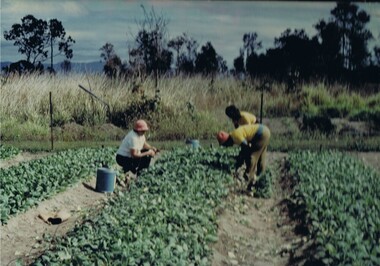
Photograph Tobacco seedlings, Pulling tobacco seedlings for Planting, Circa mid to late 1900s
... The remnants of the Tobacco Industry can still be viewed throughout the Kiewa Valley and adjacent regions on the former tobacco farms which still have the tobacco drying sheds and now converted into hay sheds. ...This promotional photograph by the Tobacco Growers Association was in response to a 1935 meeting of tobacco growers from Victoria, South Australia and Queensland which produced four major resolutions for the industry covering the remainder of the 1900s. These four resolutions were: (1) Adequate tariff protection (2) Control of pests and diseases (3) Orderly marketing (4) The formation of an advisory council of growers. History has produced the following results. (1) adequate tariff protection was never achieved,(2) control of disease through benzol vapour (CSIRO) breakthrough, was later identified as carcinogenic, (3) orderly marketing was achieved through (4) the establishment of the Tobacco Growers Association(19840. In October 2006, by way of Government buy back of tobacco leases from growers, resulted in the end of Tobacco farming in Australia (after 136 years of planting the first crop). It was also significant that the major tobacco companies such as Philip Morris and The British American Tobacco Australasia advised the industry that it would source its tobacco requirements overseas by 2009.The death of the tobacco industry(2006) resulted in the expansion of the dairy , sheep, beef cattle, venison and lama wool producers in the Kiewa Valley and surrounding regions. The remnants of the Tobacco Industry can still be viewed throughout the Kiewa Valley and adjacent regions on the former tobacco farms which still have the tobacco drying sheds and now converted into hay sheds. The problems from the large quantities of carcinogenic infused soil of farmlands in the region, still remains a problem now and for future generations. This particular photograph shows the lack of understanding by farmers and the contracted labour, at that time, and is demonstrated by the lack of protection of hands when handling seedlings and attached soil. Hand and foot protection was rarely used, even when later warnings were issued of the carcinogenic toxicity of the soil. The majority of farm owners, up until Health authorities stepped in the later stages of 1900s, were skeptical of city scientists' "carcinogenic" health warnings and it was only after the younger generation of farmers, who had graduated from Agricultural colleges, encompassed the scientific approach to farm management. The "she'll be right mate" attitude of the farming/rural community has since the 1970s been slowly dissipating. Stricter controls of herbicides and pesticides used in agriculture are now in force.Coloured photograph pasted onto a thick wood chip backing. Two galvanised eyelets at the top of the frame, 50mm from each end, with a twine cord stretch from each, for hanging purposes. See also KVHS 0054A, KVHS0054C to KVHS 0054FA sign, which has been removed from the picture at some previous point in time is "Pulling seedlings for planting"tobacco, farming, rural industry, licences, ollie mould, blue mould, benzol vapour, photograph -
 Kiewa Valley Historical Society
Photograph Topping Tobacco, Tobacco being topped (removal of flower), Circa mid to late 1900's
... The remnants of the Tobacco Industry can still be viewed throughout the Kiewa Valley and adjacent regions on the former tobacco farms which still have the tobacco drying sheds and now converted into hay sheds. ...This promotional photograph by the Tobacco Growers Association was in response to a 1935 meeting of tobacco growers from Victoria, South Australia and Queensland which produced four major resolutions for the industry covering the remainder of the 1900s. These four resolutions were: (1) Adequate tariff protection (2) Control of pests and diseases (3) Orderly marketing (4) The formation of an advisory council of growers. History has produced the following results. (1) adequate tariff protection was never achieved,(2) control of disease through benzol vapour (CSIRO) breakthrough, was later identified as carcinogenic, (3) orderly marketing was achieved through (4) the establishment of the Tobacco Growers Association(1984). In October 2006, by way of Government buy back of tobacco leases from growers, resulted in the end of Tobacco farming in Australia (after 136 years of planting the first crop). It was also significant that the major tobacco companies such as Philip Morris and The British American Tobacco Australasia advised the industry that it would source its tobacco requirements overseas by 2009.The remnants of the Tobacco Industry can still be viewed throughout the Kiewa Valley and adjacent regions on the former tobacco farms which still have the tobacco drying sheds and now converted into hay sheds. The problems from the large quantities of carcinogenic infused soil of farmlands in the region, still remains a problem now and for future generations. This particular photograph shows the lack of understanding by farmers and the contracted labour, at that time, and is demonstrated by the lack of protection of hands when handling seedlings and attached soil. Hand and foot protection was rarely used, even when later warnings were issued of the carcinogenic toxicity of the soil. The majority of farm owners, up until Health authorities stepped in the latter stages of 1900s, were skeptical of city scientists' "carcinogenic" health warnings and it was only after the younger generation of farmers, who had graduated from Agricultural colleges, encompassed the scientific approach to farm management. The "she'll be right mate" attitude of the farming/rural community has since the 1970s been slowly dissipating. Stricter controls of herbicides and pesticides used in agriculture are now in force. The death of the tobacco industry(2006) resulted in the expansion of the dairy , sheep, beef cattle, venison and lama wool producers in the Kiewa Valley and surrounding regions.Coloured photograph pasted onto a thick wood chip backing. Two galvanised eyelets at the top of the frame, 50mm from each end, with a twine cord stretch from each, for hanging purposes. See also KVHS 0054A ,KVHS 0054B and KVHC 0054D to KVHS 0054F A sign, which has been removed from the picture at some previous point in time is "The Tobacco crop being topped (flower removed)". tobacco, farming, rural industry, licences, ollie mould, blue mould, benzol vapour -
 Kiewa Valley Historical Society
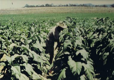
Photograph Tobacco plants, Tobacco fully grown prior to start picking, Circa mid to late 1900's
... The remnants of the Tobacco Industry can still be viewed throughout the Kiewa Valley and adjacent regions on the former tobacco farms which still have the tobacco drying sheds and now converted into hay sheds. ...This promotional photograph by the Tobacco Growers Association was in response to a 1935 meeting of tobacco growers from Victoria, South Australia and Queensland which produced four major resolutions for the industry covering the remainder of the 1900s. These four resolutions were: (1) Adequate tariff protection (2) Control of pests and diseases (3) Orderly marketing (4) The formation of an advisory council of growers. History has produced the following results. (1) adequate tariff protection was never achieved,(2) control of disease through benzol vapour (CSIRO) breakthrough, was later identified as carcinogenic, (3) orderly marketing was achieved through (4) the establishment of the Tobacco Growers Association(1984). In October 2006, by way of Government buy back of tobacco leases from growers, resulted in the end of Tobacco farming in Australia (after 136 years of planting the first crop). It was also significant that the major tobacco companies such as Philip Morris and The British American Tobacco Australasia advised the industry that it would source its tobacco requirements overseas by 2009.The remnants of the Tobacco Industry can still be viewed throughout the Kiewa Valley and adjacent regions on the former tobacco farms which still have the tobacco drying sheds and now converted into hay sheds. The problems from the large quantities of carcinogenic infused soil of farmlands in the region, still remains a problem now and for future generations. This particular photograph shows the lack of understanding by farmers, at that time, and is demonstrated by the lack of protection of hands and no masks over their noses, when handling plants. Hand, nose and foot protection was rarely used, even when later warnings were issued of the carcinogenic toxicity of the soil. The majority of farm owners, up until Health authorities stepped in the latter stages of 1900s, were skeptical of city scientists' "carcinogenic" health warnings and it was only after the younger generation of farmers, who had graduated from Agricultural colleges, encompassed the scientific approach to farm management. The "she'll be right mate" attitude of the farming/rural community has since the 1970s been slowly dissipating. Stricter controls of herbicides and pesticides used in agriculture are now in force. The death of the tobacco industry(2006) resulted in the expansion of the dairy , sheep, beef cattle, venison and lama wool producers in the Kiewa Valley and surrounding regions.Coloured photograph pasted onto a thick wood chip backing. Two galvanised eyelets at the top of the frame, 50mm from each end, with a twine cord stretch from each, for hanging purposes. See also KVHS 0054A to KVHS 0054C and 0054E to KVHS 0054FA sign, which has been removed from the picture at some previous point in time is "The Tobacco fully grown prior to start picking"tobacco, farming, rural industry, licences, ollie mould, blue mould, benzol vapour -
 Kiewa Valley Historical Society
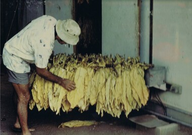
Photograph Tobacco drying leaves, Inspecting Drying tobacco leaves, 1950's to 1999
... The remnants of the Tobacco Industry can still be viewed throughout the Kiewa Valley and adjacent regions on the former tobacco farms which still have the tobacco drying sheds and now converted into hay sheds. ...This promotional photograph by the Tobacco Growers Association was in response to a 1935 meeting of tobacco growers from Victoria, South Australia and Queensland which produced four major resolutions for the industry covering the remainder of the 1900s. These four resolutions were: (1) Adequate tariff protection (2) Control of pests and diseases (3) Orderly marketing (4) The formation of an advisory council of growers. History has produced the following results. (1) adequate tariff protection was never achieved,(2) control of disease through benzol vapour (CSIRO) breakthrough, was later identified as carcinogenic, (3) orderly marketing was achieved through (4) the establishment of the Tobacco Growers Association(19840. In October 2006, by way of Government buy back of tobacco leases from growers, resulted in the end of Tobacco farming in Australia (after 136 years of planting the first crop). It was also significant that the major tobacco companies such as Philip Morris and The British American Tobacco Australasia advised the industry that it would source its tobacco requirements overseas by 2009.The remnants of the Tobacco Industry can still be viewed throughout the Kiewa Valley and adjacent regions on the former tobacco farms which still have the tobacco drying sheds and now converted into hay sheds. The problems from the large quantities of carcinogenic infused soil of farmlands in the region, still remains a problem now and for future generations. This particular photograph shows the lack of understanding by farmers and the contracted labour, at that time, and is demonstrated by the lack of protection of hands when handling the tobacco leaves and nose from tobacco dust. Hand and foot protection was rarely used, even when later warnings were issued of the carcinogenic toxicity of the soil. The majority of farm owners, up until Health authorities stepped in the later stages of 1900s, were skeptical of city scientists' "carcinogenic" health warnings and it was only after the younger generation of farmers, who had graduated from Agricultural colleges, encompassed the scientific approach to farm management. The "she'll be right mate" attitude of the farming/rural community has since the 1970s been slowly dissipating. Stricter controls of herbicides and pesticides used in agriculture are now in force. The death of the tobacco industry(2006) resulted in the expansion of the dairy , sheep, beef cattle, venison and lama wool producers in the Kiewa Valley and surrounding regions.Coloured photograph pasted onto a thick wood chip backing. Two galvanised eyelets at the top of the frame, 50mm from each end, with a twine cord stretch from each, for hanging purposes. See also KVHS 0054A to KVHS 0054D and KVHS 0054Ftobacco, farming, rural industry, licences, ollie mould, blue mould, benzol vapour, photograph -
 Kiewa Valley Historical Society
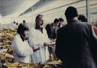
Photograph Tobacco selling, Tobacco sale floor, 1950 to 199
... This particular photograph shows prospective buyers (from the major processing firms of Philip Morris and British American Tobacco Australasia) inspecting the dried tobacco leaves at the Melbourne sales, before 2009, when they moved to overseas growers.The remnants of the Tobacco Industry can still be viewed throughout the Kiewa Valley and adjacent regions on the former tobacco farms, which still have the former tobacco drying sheds but now converted into hay sheds. ...This promotional photograph by the Tobacco Growers Association was in response to a 1935 meeting of tobacco growers from Victoria, South Australia and Queensland which produced four major resolutions for the industry covering the remainder of the 1900s. These four resolutions were: (1) Adequate tariff protection (2) Control of pests and diseases (3) Orderly marketing (4) The formation of an advisory council of growers. History has produced the following results. (1) adequate tariff protection was never achieved,(2) control of disease through benzol vapour (CSIRO) breakthrough, was later identified as carcinogenic, (3) orderly marketing was achieved through (4) the establishment of the Tobacco Growers Association(19840. In October 2006, by way of Government buy back of tobacco leases from growers, resulted in the end of Tobacco farming in Australia (after 136 years of planting the first crop). It was also significant that the major tobacco companies such as Philip Morris and The British American Tobacco Australasia advised the industry that it would source its tobacco requirements overseas by 2009.This particular photograph shows prospective buyers (from the major processing firms of Philip Morris and British American Tobacco Australasia) inspecting the dried tobacco leaves at the Melbourne sales, before 2009, when they moved to overseas growers.The remnants of the Tobacco Industry can still be viewed throughout the Kiewa Valley and adjacent regions on the former tobacco farms, which still have the former tobacco drying sheds but now converted into hay sheds. The death of the tobacco industry(2006) resulted in the expansion of the dairy , sheep, beef cattle, venison and lama wool producers in the Kiewa Valley and surrounding regions. The problems from the large quantities of carcinogenic infused soil of farmlands in the region, still remains a problem now and for future generations. The tighter restrictions of where the final product can be smoked and the higher tax levied (no tariff protection) was the main contributor to this one time lucrative industry's demise.Coloured photograph pasted onto a thick wood chip backing. Two galvanised eyelets at the top of the frame, 50mm from each end, with a twine cord stretch from each, for hanging purposes. See also KVHS 0054A to KVHS 0054EA sign, which has been removed from the picture at some previous point in time is "Tobacco sale floor"tobacco, farming, rural industry, licences, ollie mould, blue mould, benzol vapour, photograph -
 Kiewa Valley Historical Society
Photograph Farm Land, Mount Beauty Acreage before Golf Course, Circa 1950
... viewed towards Mount Bogong and its Alpine ranges. The photo is on 200gms paper and not on photographic paper. Mount Beauty Acreage before Golf Course Photograph Farm Land Mr. ...This photograph is a "snap shot" in time circa 1950s detailing the rural environment before the effects of the Kiewa Valley Hydro Scheme altered the basic rural setting of the valley. The golfing fairway was being mapped out on previous grazing land, before the laying of a golf course, for use by the construction workers and auxiliary administration employees of the Victorian State Electricity Commission. This photograph details a dramatic period in time which saw an enormous change to the exclusively rural area of the Kiewa Valley region in the mid 1900s. This change presented both physical and mental challenges to the existing quiet rural inhabitants of the valley. The State of Victoria had to make adjustments to the changing demands imposed by population and industrial expansions. The development of cleaner energy supplies to a growing population has its downside ,which ever way the intrusion into the "natural" landscape is made.Black and white photograph detailing surveyor posts for construction of golf course. Land used, before establishment of the Mount Beauty Village, as farming/grazing cattle and viewed towards Mount Bogong and its Alpine ranges. The photo is on 200gms paper and not on photographic paper.nilmount beauty in the 1940s - 1950s, grazing in the kiewa valley, sec victoria -
Eltham District Historical Society Inc
Document - Folder, Ness family
... farm...Wellers Hotel...Betsy Sadler...Ingleside Kangaroo Ground...James Mess...Jane Stevenson...Ness Lane Kangaroo Ground...View...Ness family Kangaroo Ground James Johnston Kangaroo Ground Pretty Hill farm Wellers Hotel Betsy Sadler Ingleside Kangaroo Ground James Mess Jane Stevenson Ness Lane Kangaroo Ground View Hill Kangaroo Ground Stte Savings Bank agency Ruth Lettice Gosling nee Mess Kangaroo Ground State School Garden Hills Kangaroo Ground William Mess Joseph Mess Isabella Mess James Johnson Mess Ruth Ettie Mess George Mess Alexander Mess Janes Mess Robert David Mess Heidelberg Agricultural Show Diamond Creek Agricultural Show Rober James Ness Pearl Ness nee Mills William Mills Sabina Mills Robert Bruce Ness Beryl Ness Vera Ness Donald Ness Kangaroo Ground Presbyterian Church Kangaroo Ground Cemetery trust Kangaroo Ground Tennis Club Professor Osborne Doctor Osborne Joseph Stevenson Joy Ness Kangaroo Ground Fire Brigade Bruce Ness Country Fire Authority ship Wellington 1837 Diamond Creek David Christmas Christmas Hills Andres Harkness Samuel Furphy Andrew Ross Caledonian gold fields Queenstown now St Andrews Mother Coleman of Kangaroo Ground Diamond Valley Arts Society Winifred Joy Ness Andrew Ross Museum Eltham Art Show Newspaper clippings, A4 photocopies, etc Ness family Document Folder ...James Johnston settled at Kangaroo Ground in 1849. His nephew James Mess joined him and a descendant Robert James Mess changed his surname to Ness. The family became active in all aspects of Kangaroo Ground life. Contents Text (handwritten and transcribed): "The Ness Family, Kangaroo Ground", Joy Ness, 1989. Newspaper article: "True pioneer stock", Diamond Valley News, 2 March 1982. History of the Mess/Ness family Newspaper article: "Ness family are keepers of 140 years of historical knowledge", Diamond Valley News, 4 February 1986. History of Joseph Stephenson and descendants. Newspaper article: "Joy Ness paints native flowers for posterity". Diamond Valley News, 21 October 1986. Life and career of Joy Ness as painter. Newspaper article: "His Cup runneth of with Joy", ?Diamond Valley Leader, 6 December 2000. Bruce and Joy Ness celebrate 60th wedding anniversary. Pencil sketch by Joh Ebeli no date but pre 2004: Portrait of Joy Ness dressed for the Historical Society Parade. Order of Service: Thanksgiving service for the life of Robert Bruce Ness 22 January 1917 / 28 June 2004. Eltham District Historical Society newsletter no date: "Robert Bruce Ness 1917-2004", obituary and extract from Joy Ness's history of the family. Copy of letter from Joh Ebeli to Gwen Orford, no date but ~2004: Describes drawings he made of Robert Bruce Ness when taking part in Diamond Valley Arts Society float and enclosed 3 drawings and a photograph of drawing of the bakers (corner Main Road and York Street Eltham). Eltham District Historical Society newsletter September 2013: "Vale Joy Ness", obituary and extract from Diamond Valley News article of 6 December 2000.Newspaper clippings, A4 photocopies, etcness family kangaroo ground, james johnston, kangaroo ground, pretty hill farm, wellers hotel, betsy sadler, ingleside kangaroo ground, james mess, jane stevenson, ness lane kangaroo ground, view hill kangaroo ground, stte savings bank agency, ruth lettice gosling nee mess, kangaroo ground state school, garden hills kangaroo ground, william mess, joseph mess, isabella mess, james johnson mess, ruth ettie mess, george mess, alexander mess, janes mess, robert david mess, heidelberg agricultural show, diamond creek agricultural show, rober james ness, pearl ness nee mills, william mills, sabina mills, robert bruce ness, beryl ness, vera ness, donald ness, kangaroo ground presbyterian church, kangaroo ground cemetery trust, kangaroo ground tennis club, professor osborne, doctor osborne, joseph stevenson, joy ness, kangaroo ground fire brigade, bruce ness, country fire authority, ship wellington 1837, diamond creek, david christmas, christmas hills, andres harkness, samuel furphy, andrew ross, caledonian gold fields, queenstown now st andrews, mother coleman of kangaroo ground, diamond valley arts society, winifred joy ness, andrew ross museum, eltham art show -
 Eltham District Historical Society Inc
Photograph - Digital Photograph, Marguerite Marshall, Eltham Lower Park, 20 April 2008
... The Lenister Farm wetland includes a bird hide, viewing platform and interpretive signs.5 Pioneer Henry Stooke, later Road Board chairman, bought the 11 acres (4.5ha) - later to become Lenister Farm - from the Crown in 1862. ...The Lenister Farm wetland includes a bird hide, viewing platform and interpretive signs.5 Pioneer Henry Stooke, later Road Board chairman, bought the 11 acres (4.5ha) - later to become Lenister Farm - from the Crown in 1862. ...Originally a race course, the park has brought the community together with a variety of activities. Published: Nillumbik Now and Then / Marguerite Marshall 2008; photographs Alan King with Marguerite Marshall.; p45 Once used for horse racing, which attracted visitors from Melbourne, the Eltham Lower Park has brought the community together with a wide range of activities. Horse riding is now enjoyed as a recreation in the park as are other sports. The park also includes the Diamond Valley Railway miniature trains and a sanctuary for the rare and vulnerable Eltham Copper Butterfly. Eltham Lower Park, with other parks, forms an almost continuous green band from Eltham’s centre, along the Diamond Creek to the Yarra River.1 Before European settlement the Wurundjeri people met on this land, particularly at the junction of the Diamond Creek with the Yarra River, which they called Birr-arung. This is commemorated by the sculpture, Not just a Pretty Place by Aleks Danko, winner of the 2000 Nillumbik Art in Public Places Award. The first European to settle here was probably Henry Foley, who in 1841 used it as part of his pastoral run. Foley sold his leasehold to Joseph Wilson in 1845, who soon after sold it to Frederick Falkiner. During the 1840s the future park was part of a government square mile (2.6 sqkm) reserve, north of the Yarra, within the Parish of Nillumbik, later named Eltham. Soon the land was used for horse racing after nearby residents cleared ten acres (4ha) in the early 1850s. A three-quarter of a mile (1.2km) race secured the winner the £10 Publican’s Prize. In response to popular demand, the newly formed Eltham District Road Board petitioned the Surveyor General of the Colony of Victoria, in 1856, for 36 acres (14.6ha) of crown land for a racecourse and recreation. By 1858 the Eltham races had become an institution. ‘Many skirmishes occurred and the way home was paved with temptation, with sly-grog for sale.3 In the early 1870s, two jockeys were sons of the police officer in charge of the Eltham Police Station, Miles S Lyons. Another ten acres (4ha) was added to the area in 1866 and 12 acres (4.8ha) – Hohnes Hill – in 1870. In 1866, two acres (0.8ha) on the creek banks became an animal pound with William Walsh the pound keeper in 1870, but this was later incorporated into the park. By 1877 the area was called a public park but horse racing and training continued into the 1920s. In the mid-1900s trotters were trained on a circuit road. In 1953 the Eltham Pony Club was established and used a cross-country course on Hohnes Hill. From the mid 1950s the club held the Eltham Easter Fair at the park, later to include a procession along Main Road from the town centre to the park. The park also attracted picnic parties and campers from the inner suburbs as did Wingrove Park, and businesses catering for visitors, sprang up on the opposite side of Main Road. Bus-loads of school children visited the park for Gould League bird days in the 1960s. In 1979 the Eltham Shire Council bought Lenister Farm, linking the park with the Yarra River. The Lenister Farm wetland includes a bird hide, viewing platform and interpretive signs.5 Pioneer Henry Stooke, later Road Board chairman, bought the 11 acres (4.5ha) - later to become Lenister Farm - from the Crown in 1862. Stooke never lived on this site and the two houses at Lenister Farm were built in the 20th century. Since its formation in 1871, the Council has controlled this crown land, which it named Eltham Park. But in the 1920s Eltham Council bought land near the town centre for a park, which it named Eltham Central Park. To avoid confusion the Council renamed Eltham Park, Eltham Lower Park. Since 2004 the Yarra footbridge has linked the park with the Yarra Valley Metropolitan Park and the Main Yarra Trail.This collection of almost 130 photos about places and people within the Shire of Nillumbik, an urban and rural municipality in Melbourne's north, contributes to an understanding of the history of the Shire. Published in 2008 immediately prior to the Black Saturday bushfires of February 7, 2009, it documents sites that were impacted, and in some cases destroyed by the fires. It includes photographs taken especially for the publication, creating a unique time capsule representing the Shire in the early 21st century. It remains the most recent comprehenesive publication devoted to the Shire's history connecting local residents to the past. nillumbik now and then (marshall-king) collection, eltham lower park, eltham park -
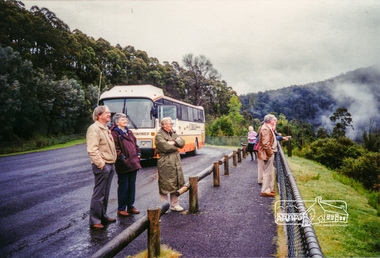 Eltham District Historical Society Inc
Photograph, Upper Yarra Dam, Spring Tour, 22 Oct 1995, 22/10/1995
... Starting by crossing the new (1974) concrete bridge at Warrandyte we headed through Wonga Park with views to the Christmas Hills and to the escarpment of the Yering Gorge, which causes flood waters to back up through the Yarra Glen plain, so avoiding disasters downstream. At the end of a long driveway we found the wooden, privately owned Henley Bridge (1935 after the 1934 floods). This facilitates access to different parts of Henley Farm...Starting by crossing the new (1974) concrete bridge at Warrandyte we headed through Wonga Park with views to the Christmas Hills and to the escarpment of the Yering Gorge, which causes flood waters to back up through the Yarra Glen plain, so avoiding disasters downstream. At the end of a long driveway we found the wooden, privately owned Henley Bridge (1935 after the 1934 floods). This facilitates access to different parts of Henley Farm ...EXPLORING THE UPPER YARRA (Newsletter No. 105, November 1995, by Bettina Woodburn) We enjoyed the Spring Excursion, this year "Exploring the Upper Yarra" - in spite of the constant rain and the countryside under the cloud cover, especially in the valleys, being mainly shiny shades of green. The occasional fields of buttercups, clumps of arum lilies and splendid rhododendron and other flowering bushes became very special. The Cobb and Co coach was warm and a cosy retreat as we zig-zagged on the highways and byways to glimpse the Yarra River, upstream and down, its secret places, and particularly the many bridges. Russell excelled as 'Poet Laureate', reading from Dacre Smyth's book. This 1979 publication includes paintings of all the bridges along the river with poems and brief descriptions of each one. Some of the bridges are in out of the way places and are not very well known. We looked forward to hearing the poetry as much as seeing the ' constructions'…Big Pat (was he short or tall, lean or fat? He did win the two hundred pound reward for discovering gold and had the creek named after him), about the 'Eddies'?, and the disliked 'meccano' bridge in Warburton, etc. etc. The hot roast lunch in the old Reefton Hotel was also most welcome. It was easy to imagine it peopled by miners and early settlers. Starting by crossing the new (1974) concrete bridge at Warrandyte we headed through Wonga Park with views to the Christmas Hills and to the escarpment of the Yering Gorge, which causes flood waters to back up through the Yarra Glen plain, so avoiding disasters downstream. At the end of a long driveway we found the wooden, privately owned Henley Bridge (1935 after the 1934 floods). This facilitates access to different parts of Henley Farm and to Lilydale. Everard Park, named after Blanche Shallard's father, a State Member for 17 years, below the Highway Yarra crossing was in need of care. It is 10 miles from Yarra Glen by road but, as "Yarra Marra” canoeists well know, 32 winding miles down by water. After more delightful countryside scenes we joined the Warburton Highway at Woori Yallock. From the old Railway Station at Launching Place the Centennial Trail for walkers, cyclists and ' horse riders has replaced the rails. The line from Lilydale was opened in 1901, and the last diesel freight train ran to Warburton in 1965. It continued to rain as we had morning tea in Warburton in a shelter between footbridges. From here we continued upstream past the Bridge to O'Shannasy Lodge and Reservoir, Starvation Creek, and the Peninsular tunnel (miners dug it as at Pound Bend) which we visited (scrambling down those steps!) on our return after lunch. Our furthermost point was the Upper Yarra Dam Reserve (and vast catchment area). Finished in 1957 after ten years work and 100 years after Yan Yean, it supplies much of Melbourne's water. After crossing the 30m Launching Place Bridge to the Eltham side of the Yarra and Healesville, we saw in the distance the Yarra Glen Timber Trestle Bridge over the river flats "the longest for years in the land it was said!" Harry's dream of "better weather over the Divide" unfortunately didn't come true, but I'm sure we 36 members will retain happy memories of a day that was wet and green and filled with Bridges. Bettina Woodburn - October 1995 Record of the Society's history of activities - Spring 1995 excursionColour photographshire of eltham historical society, activities, upper yarra dam, henley bridge -
 Eltham District Historical Society Inc
Photograph, Peter Pidgeon, Site of former pond, Main Road, Eltham, 2 Aug. 2022
... The view is taken from Maria Street (Main Road) opposite Dalton Street looking northwest across the Dalton Street road extension reserve (now Wingrove Park Trail) and Jarrold farm. ...The view is taken from Maria Street (Main Road) opposite Dalton Street looking northwest across the Dalton Street road extension reserve (now Wingrove Park Trail) and Jarrold farm. ...The view is taken from Main Road opposite Dalton Street looking northwest across Wingrove Park Trail and White Cloud cottage which belonged to the Jarrold family Comparison photo: 00779 - Pond near Eltham Park, c.1910 Shows the pond near Eltham Park (later Eltham Lower Park) circa 1910. The view is taken from Maria Street (Main Road) opposite Dalton Street looking northwest across the Dalton Street road extension reserve (now Wingrove Park Trail) and Jarrold farm. A haystack is visible. Also visible is a kerosene streetlight and Jarrold family cottage The pond was drained by Council in 1932 due to claims of mosquitoes though locals such as Thekla Jarrold and John Clark disputed this and protested to Council about the draining. It was in this news article that Thekla stated she had lived there 39 years and John Clark 22 years without cause for concern. Part of a presentation by Peter Pidgeon to the Society, 13 August 2022 showcasing a series of photographs taken by John Henry Clark over the period 1895 to 1930. John Henry Clark was the youngest of three boys born to William Henry Clark (1823-1877) and Maria White (1843-1914). He and his brothers, William Charles Clark (1872-1945), Clement Kent Clark (1874-1912) operated a photography business (Clark Bros.) from 25 Thomas Street, Windsor near Prahran during the period c.1894 to 1914. Following death of Clement in September 1912 and their mother in 1914, the Clark Bros business appears to have dissolved, the premises demolished, and a new house was under construction in 1915. John set up business independently in 1914 operating out of 29 Moor Street, Fitzroy where he is registered in the 1914 and 1915 Electoral Rolls. By 1916 John had relocated to Eltham where he continued his practice as a photographer and took many of the early images around the district of Little Eltham. Around 1930 John changed professions and opened a small cobbler's shop in 1931 near the pond opposite Dalton Street adjacent to the Jarrold family cottage. He never married and continued his profession as a bootmaker from this little shop, maintaining a close relationship with Mrs Jarrold for the rest of their lives. His bootmaker shop remains today beside the Whitecloud cottage and is one of only three remaining shops in the area from the early 20th century.Comparative photo taken 2022 with one taken from same location over 100 years earlier by noted local photographer J.H. ClarkBorn Digitaleltham, j.h. clark photo (2022), bootmaker's shop, dalton street, diamond creek trail, jarrold cottage, main road, white cloud cottage, wingrove park trail -
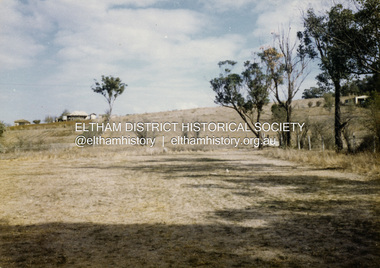 Eltham District Historical Society Inc
Colour Print, David Taylor, Maurie Fabbro's home viewed from the rear of Eltham High School, c.1976
... Eltham District Historical Society Inc 728 Main Rd Eltham melbourne Viewed from the near the western boundary of the school near the Athletic field David Taylor Collection Eltham Eltham High School Fabbro's farm Colour print contained in TOMMY green vinyl self adhesive photo album, 30 x 26 x 2.5 cm Digital scan file only Maurie Fabbro's home viewed from the rear of Eltham High School Colour Print David Taylor ...Viewed from the near the western boundary of the school near the Athletic fielddavid taylor collection, eltham, eltham high school, fabbro's farm -
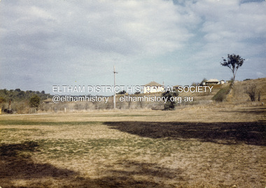 Eltham District Historical Society Inc
Colour Print, David Taylor, Maurie Fabbro's home viewed from the rear of Eltham High School, c.1976
... Eltham District Historical Society Inc 728 Main Rd Eltham melbourne Viewed from the near the western boundary of the school near the Athletic field David Taylor Collection Eltham Eltham High School Fabbro's farm Colour print contained in TOMMY green vinyl self adhesive photo album, 30 x 26 x 2.5 cm Digital scan file only Maurie Fabbro's home viewed from the rear of Eltham High School Colour Print David Taylor ...Viewed from the near the western boundary of the school near the Athletic fielddavid taylor collection, eltham, eltham high school, fabbro's farm