Showing 138 items matching "fern house"
-
 Bendigo Military Museum
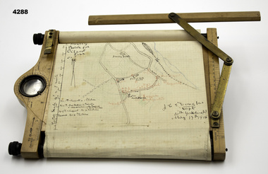
Equipment - OBSERVERS MAP BOARD, J.Hicks, 1909
... ...Hawley House, Fern Hill House...Equipment OBSERVERS MAP BOARD J.Hicks Hawley House, Fern Hill House ...Original owner, Major John Charles Edward Douglas 400th Bn Yorkshire Regt who died aged 39 on Saturday 18th December 1915, Major Douglas was the son of Admiral Sir Archibald Douglas GCB, GCVO, LL.D, JP and Lady Douglas Barrister, Gray’s Inn. Remembered with with HONOR, Bailleul Communal cemetery Extentsion (Nord) Nard France 11.B.64.Rectangular wooden board, rotating metal bezel ring, markings, compass, clinometer, leather straps, graph paper, wooden ruler, with attached brass folding hinge.“Hawley sketch for Outpost Line”, “JCE Douglas Capt, 10th Yorkshire Regt May 17th 1915”equipment, maps -
 Ballaarat Mechanics' Institute (BMI Ballarat)
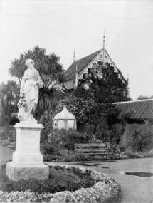
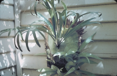
Fern House & Floral Statue
... Fern House & Floral Statue...Ballarat Botanical gardens fernery statue Fern House & Floral Statue ...This photograph is from the Max Harris Collection held by the Ballaraat Mechanics' Institute. Please contact BMI for all print and usage inquiries.ballarat, botanical gardens, fernery, statue -
 The Beechworth Burke Museum
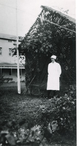
Photograph - Photograph Reproduction, 1998
... ...fern house...The photograph, created in 1998, is a copy of the original one, depicting a nurse in uniform at the Mental Hospital in Beechworth, with a fern house behind her. In the background, the two-storey building is in view, along with the covered walkway. ...The Beechworth Burke Museum Loch Street Beechworth high-country The photograph, created in 1998, is a copy of the original one, depicting a nurse in uniform at the Mental Hospital in Beechworth, with a fern house behind her. In the background, the two-storey building is in view, along with the covered walkway. ...The photograph, created in 1998, is a copy of the original one, depicting a nurse in uniform at the Mental Hospital in Beechworth, with a fern house behind her. In the background, the two-storey building is in view, along with the covered walkway. The institution had to operate with serious shortage of female nurses for long periods of time. During the 1880s, small houses (cottages) were built to offer accommodation for the nurses living in the hospital and in 1937 began the construction of a nurses` hostel. In 1962 the upper level of the Nurses` Home was converted into a Nurses` Training School. The Mayday Hills Hospital was constructed between 1864 and 1867, with buildings created in a number of periods. It formally opened on 24 October 1867 and, along with the Ovens Hospital and the Benevolent Asylum, made Beechworth a prominent social welfare centre in Victoria. The need for an institution of this kind was arisen due to the increased number of people with mental disturbances (induced by the harsh living conditions on the goldfields) and the remoteness of the district from Melbourne. The two-storey buildings, designed in Italianate style, and the three-storey towers at the front, were influenced by the asylum at Colney Hatch in England. Large masses of granite were excavated for its foundation and around 250 workmen were employed for its construction. The building, divided into six sections, was comprised of dormitories, doctors` rooms and plenty ancillary rooms and facilities, such as laundries, reading rooms, a concert hall and cooking areas. The site was chosen for its panoramic view of the countryside, the hilltop atmosphere and the native fauna, all contributing to the cure of patients. The Hospital was originally named the “Ovens Lunatic Asylum” but, during the centenary celebrations in 1967, the name was officially changed to “Mayday Hills Hospital”, showing the gradual shift in the perception and understanding of mental health conditions over the last decades. The Hospital lies on the traditional land of the Kulin Nation.This photograph is historically significant as it provides an insight into the everyday life of staff living within the walls of the Mayday Hills Hospital. It also offers important information about the location and the exterior of the Hospital and contributes to the understanding of the district`s development and its importance to the course of Victoria`s history.Black and white rectangular photograph printed on paper unframed.Reverse: 3445/mental hospital, beechworth, fern house, female nurses, nurses` home, nurses` training school, nurses` hostel, mayday hills hospital, ovens hospital, colney hatch, two-storey buildings, italianate style, benevolent asylum, ovens lunatic asylum, kulin nation, workmen, covered walkway, granite, hilltop atmosphere, mental health -
 Glen Eira Historical Society
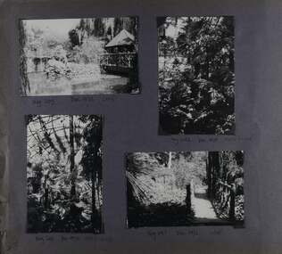
Album - Album page, Ripponlea, Hotham Street, Circa 1972
... Handwritten: Neg 239 Dec 1973 LAKE [under top left photo] / Neg 242 Dec 1973 FERN HOUSE [under top right photo] / Neg 243 Dec 1972 FERN HOUSE [under bottom left photo] / Neg 241 Dec 1972 LAKE [under bottom right photo] / 93 [bottom left]...It was built about 1884. trevor hart elsternwick mansion hotham street frederick sargood sargood reed and barnes 1860's 1890's 1880's benjamin nathan nathan louisa jones thomas bent sir thomas bent william guilfoyle adam anderson lake grotto shade house portico ripponlea victorian sir frederick sargood architects taylor and fitts rippon lea gardens ferns bridges walking trails Handwritten: Neg 239 Dec 1973 LAKE [under top left photo] / Neg 242 Dec 1973 FERN HOUSE [under top right photo] / Neg 243 Dec 1972 FERN HOUSE [under bottom left photo] / Neg 241 Dec 1972 LAKE [under bottom right photo] / 93 [bottom left] Page 93 of Photograph Album with four photographs (two landscape and two portrait) of Ripponlea - lake and gardens. ...This photograph is part of the Caulfield Historical Album 1972. This album was created in approximately 1972 as part of a project by the Caulfield Historical Society to assist in identifying buildings worthy of preservation. The album is related to a Survey the Caulfield Historical Society developed in collaboration with the National Trust of Australia (Victoria) and Caulfield City Council to identify historic buildings within the City of Caulfield that warranted the protection of a National Trust Classification. Principal photographer thought to be Trevor Hart, member of Caulfield Historical Society. Most photographs were taken between 1966-1972 with a small number of photographs being older and from unknown sources. All photographs are black and white except where stated, with 386 photographs over 198 pages.From Victorian Heritage Database citation for Rippon Lea H0614 https://vhd.heritagecouncil.vic.gov.au/places/427(as at 23/10/2020) Rippon Lea was commenced in 1868 by Frederick Sargood, a most successful politician and merchant. He was born in England in 1834 and arrived in Melbourne in 1850. He soon joined his father's wholesale soft goods firm, spending some time as its manager on the goldfields. Sargood entered the Legislative Council in 1874. He was Victoria?s first Minister for Defence in 1883. Sir Frederick Sargood was created CMG. In 1885 and KCMG in 1890 as a reward for his contribution to public life. He died suddenly in 1903. Rippon Lea was designed by the leading firm of architects, Reed and Barnes. Joseph Reed had travelled in Europe in 1863, including northern Italy. When he returned he introduced the use of polychromy. While not the first examples, Rippon Lea and the Independent Church in Collins Street were the best and set a fashion which became a distinctly Melbourne style, particularly used for houses and churches. Its popularity was possible because of the new availability of different coloured bricks. Reed's fine Lombardic Romanesque details soon became debased by others. As Sargood's family grew and his fortunes prospered, Rippon Lea was extended to include 33 rooms - a complete mansion. The cast iron porte cochere and the northern conservatory were added in 1897. The architects were Taylor and Fitts. The ballroom was added in 1882 and remodelled in 1889. Many alterations have changed the interior and exterior during the ownerships of Benjamin Nathan and later his daughter Mrs Louisa Jones in the 1930s and are in their own right of significance. Sir Thomas Bent owned the property from 1903 until 1911 but never lived there. He subdivided much of the land. The original garden dates from about 1868, and it seems that William Guilfoyle of the Botanic Gardens was involved. It was redesigned in a more natural style in the 1880s by Sargood and his head gardener, Adam Anderson. The lake, waterfalls, fernery, hill and grotto are balanced by mighty deciduous trees and conifers. These are interspersed with, but never dominated by Australian species such as eucalyptus and other exotics. The sinuous drive with its carefully prepared approach to the house is notable. The original vegetable gardens, orchard and outer paddocks no longer survive. The shade house is important as the largest known in Australia and possibly the world. Its curved plan and form of construction are particularly notable. It was built about 1884.Page 93 of Photograph Album with four photographs (two landscape and two portrait) of Ripponlea - lake and gardens.Handwritten: Neg 239 Dec 1973 LAKE [under top left photo] / Neg 242 Dec 1973 FERN HOUSE [under top right photo] / Neg 243 Dec 1972 FERN HOUSE [under bottom left photo] / Neg 241 Dec 1972 LAKE [under bottom right photo] / 93 [bottom left]trevor hart, elsternwick, mansion, hotham street, frederick sargood, sargood, reed and barnes, 1860's, 1890's, 1880's, benjamin nathan, nathan, louisa jones, thomas bent, sir thomas bent, william guilfoyle, adam anderson, lake, grotto, shade house, portico, ripponlea, victorian, sir frederick sargood, architects, taylor and fitts, rippon lea, gardens, ferns, bridges, walking trails -
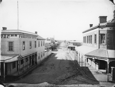 Stawell Historical Society Inc
Photograph, Main Street & Patrick Streets corner looking East down Patrick Street with the Foresters Hotel on left corner 1878
... House. The building was sold in 1935 and demolished shortly after sale. Businesses visible down Patrick street, Foresters Hotel, J.H. Wallis Royal Exchange Hotel on Big Hillside of Street. With St Patrick's church tower visible in distance. Melbourne Cash Store Wines and Spirits on corner of Patrick and Sloane Street near centre of photo. Ferns...Foresters Hotel on left. Fern Boarding House on right....Foresters Hotel on left. Fern Boarding House on right. Main Street & Patrick Streets corner looking East down Patrick Street with the Foresters Hotel on left corner 1878 Photograph ...First floor view from corner of Main & Patrick Streets looking East down Patrick Street. Weatherboard Foresters Hotel in Main Street on left corner. Foresters Hotel was built in 1868 by Mr. Joseph Cawley, Mr. and Mrs. Cawley were the occupants for 30 years. The site was previously occupied by a Billiards Room. In 1917 the building became Foresters Coffee Palace with new owner Mr. J.C. Crothers who purchased the building for 410 pounds and leased it to Mr. Robert Wennerbom. The next lease holder was Miss Fulton and in 1921 Mrs. R. Claringbold took over and called the building Foresters House. The building was sold in 1935 and demolished shortly after sale. Businesses visible down Patrick street, Foresters Hotel, J.H. Wallis Royal Exchange Hotel on Big Hillside of Street. With St Patrick's church tower visible in distance. Melbourne Cash Store Wines and Spirits on corner of Patrick and Sloane Street near centre of photo. Ferns Hotel / Times office on right of photo, corner of Patrick and Main Street. Post Box on Corner at right of photo. 1878First floor view from Main Street Patrick Street intersection looking down Patrick Street. Foresters Hotel on left. Fern Boarding House on right.Victorian Views. C. Herbert, Photo. Stawell 1878stawell businesses streetscape -
 Mt Dandenong & District Historical Society Inc.
Photograph, Isaac Jeeves First Home, 1917
... Behind them is the roof of the house with the tree fern floor. The glass house came much later....Behind them is the roof of the house with the tree fern floor. The glass house came much later. isaac jeeves Isaac Jeeves Jeeves Kalorama pioneer Black and white photograph showing the first home of early settler Isaac Jeeves. ...Isaac Jeeves arrived in 1857 to take up land. The photograph taken in 1917 shows his first home, which he left c1872. The small building in the right foreground was his first dwelling. On the left is a barn. Behind them is the roof of the house with the tree fern floor. The glass house came much later.Black and white photograph showing the first home of early settler Isaac Jeeves. Photo taken in 1917.isaac jeeves, isaac jeeves, jeeves, kalorama, pioneer -
 Mt Dandenong & District Historical Society Inc.
Photograph, Harmony Vale, c1913
... Richardsons (Jeannie’s) “Mt Calvin” between trees above tree fern. Isaac Jeeves house with the tree fern floor among trees against forest right centre. ...Richardsons (Jeannie’s) “Mt Calvin” between trees above tree fern. Isaac Jeeves house with the tree fern floor among trees against forest right centre. ...View of Harmony Vale, the original Kalorama settlement taken from Barbers Road. Child's sawmill can be seen (centre) with the log yard to the right. Richardson's home "Harmony Vale' is in the orchard above the logs.Black and white photograph copied from a Rose Series postcard showing the area known as "Harmony Vale' - the original Kalorama settlement. Child's sawmill is in the centre.Rose Series Photo of Harmony Vale on the Olinda Creek taken from Logans Lot 28. Link Rd crossing centre Shiloah complex left centre. Richardsons (Jeannie’s) “Mt Calvin” between trees above tree fern. Isaac Jeeves house with the tree fern floor among trees against forest right centre. Mill yard with logs above cultivated flat. Mill to left. “Harmony Vale” homestead among orchard above logs. “Glenrivers” in gully at top of clearing. About 1913. Copied JLC 1973harmony vale, harmony vale, child's sawmill, sawmill, barbers road, richardson, shiloah -
 Bendigo Historical Society Inc.
Photograph - PHOTO OF TWO YOUNG LADIES, 1890
... House 11 Mackenzie Street Bendigo goldfields PERSON Group portrait Alans Studio. 318 Smith street. Collingwood. All kinds of photography excuted in best style. Hand coloured photo of two young ladies. 1. Lady standing in long brown dress, white lace collar, pink bow, gold broch, blue eyes, fair hair clipped up in bun with red leaf in hair. 2. Lady sitting, in long brown dress, white lace collar, orange neck band, orange broach, blue bow. Green bush and ferns ...Hand coloured photo of two young ladies. 1. Lady standing in long brown dress, white lace collar, pink bow, gold broch, blue eyes, fair hair clipped up in bun with red leaf in hair. 2. Lady sitting, in long brown dress, white lace collar, orange neck band, orange broach, blue bow. Green bush and ferns in background.Alans Studio. 318 Smith street. Collingwood. All kinds of photography excuted in best style.person, group, portrait -
 Bendigo Historical Society Inc.
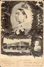
Photograph - SOUVENIR DIAMOND JUBILEE, 1897, POSTCARD, c.1897
... History House 11 Mackenzie Street Bendigo goldfields TOPIC Black and white photo of Queen Victoria, in profile, wearing official robes (with insignia VR) and a lace cap surmounted by a small crown. Head and shoulders only. She is surrounded by a wreath of fern ...Black and white photo of Queen Victoria, in profile, wearing official robes (with insignia VR) and a lace cap surmounted by a small crown. Head and shoulders only. She is surrounded by a wreath of fern leaves. The photo is a souvenir, produced by Albert Bush, whose photo is in the lower rh corner, also with a fern surround. To the left of him, is a photo of his corner store, with workers in the street at front (eighteen people). In front of the store is also a horse and carriage and a horse drawn wagon loaded with bags of produce (wheat?). The triple photos are a souvenir for Queen Victoria's Diamond Jubilee, 1897 and also an advertisement for Albert Bush's Grocery Store.topic -
 Bendigo Historical Society Inc.
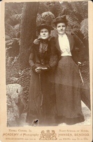
Photograph - FEMALE PORTRAIT, approx. 1910
... History House 11 Mackenzie Street Bendigo goldfields PERSON Group Academy of photography, Hansen, Bendigo sepia photo mounted on cream board. Two female figures standing under tree,. Ferns ...sepia photo mounted on cream board. Two female figures standing under tree,. Ferns in background, rocks and creeper, female s dressed in long skirts, jackets, hats, holding parasols, fernery, Rosalind Park ?Academy of photography, Hansen, Bendigoperson, group -
 Bendigo Historical Society Inc.
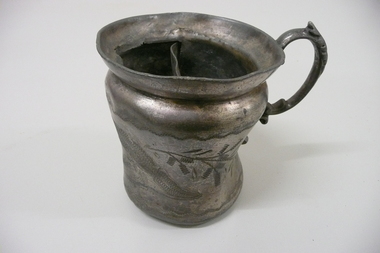
Domestic Object - SHAVING MUG
... History House 11 Mackenzie Street Bendigo goldfields PERSONAL EFFECTS Shaving mug Regd trade Mark British 122 Britannia metal shaving mug with fancy scrolled handle, engraved design of fern leaves, divided compartment with drain holes. ...Britannia metal shaving mug with fancy scrolled handle, engraved design of fern leaves, divided compartment with drain holes.Regd trade Mark British 122personal effects, shaving, mug -
 Bendigo Historical Society Inc.
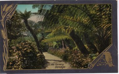
Postcard - CARWARDINE COLLECTION: IN THE FERNERY BENDIGO
... History House 11 Mackenzie Street Bendigo goldfields BENDIGO Business Carwardine Soap and Candle The Valentine & Sons Publishing Co., Ltd., Melbourne Coloured postcard, grey border embellished with sheaf of wheat left hand side, and kookaburra bottom RH corner. Image shows large ferns ...Coloured postcard, grey border embellished with sheaf of wheat left hand side, and kookaburra bottom RH corner. Image shows large ferns and gravel path in centre. Written on bottom of card 'In the Fernery, Bendigo' Receipt number 355/16The Valentine & Sons Publishing Co., Ltd., Melbournebendigo, business, carwardine soap and candle -
 Bendigo Historical Society Inc.
Slide - GARDEN (FLOWERS) 12 HOPE STREET, Nov 1960
... History House 11 Mackenzie Street Bendigo goldfields SLIDE Bendigo garden (flowers) 12 hope street. Garden (Flowers) 12 Hope Street. Slide, Garden (Flowers) 12 Hope Street.Elk horn fern. ...Slide, Garden (Flowers) 12 Hope Street.Elk horn fern.slide, bendigo, garden (flowers) 12 hope street., garden (flowers) 12 hope street. -
 Bendigo Historical Society Inc.
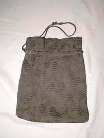
Clothing - MERLE HOULDEN COLLECTION: BLACK COTTON DRAWSTRING BAG, 1940's-50's
... History House 11 Mackenzie Street Bendigo goldfields COSTUME Female drawstring bag Drawstring bag - embroidered cotton - embroidered "fern - like" pattern woven into the fabric. ...Drawstring bag - embroidered cotton - embroidered "fern - like" pattern woven into the fabric. Brown cotton lining, with gold coloured cotton lining the upper edge of the bag. Casing 1 cm wide, sewn 4.5 cm from top edge. Black cord threaded through the casing. Machine stitched.costume, female, drawstring bag -
 Bendigo Historical Society Inc.
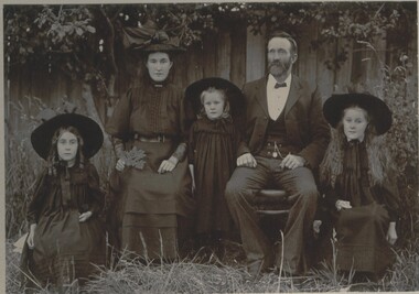
Photograph - FAMILY PHOTO, 1890's ?
... History House 11 Mackenzie Street Bendigo goldfields PERSON Family Mac Korumburra black and white photo: seated male and female with three girls ( daughters ? ) in foreground. Seated outside, in background paling fence, longish grass surrounds group. Male dressed in black coat, white shirt, bow tie. Female - long dark dress, hat, holding fern ...black and white photo: seated male and female with three girls ( daughters ? ) in foreground. Seated outside, in background paling fence, longish grass surrounds group. Male dressed in black coat, white shirt, bow tie. Female - long dark dress, hat, holding fern frond in hand. Three girls, dark dresses, large hats.Mac Korumburraperson, family -
 Bendigo Historical Society Inc.
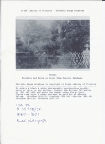
Photograph - LOWER CAMP RESERVE, SANDHURST, 1889 ?
... History House 11 Mackenzie Street Bendigo goldfields PLACE Landscape view lower camp reserve sandhurst photographs Sandhurst garden reserve Bendigo photography fountains ferns Rudd Black and white photocopy of fountain and ferns in Lower Camp Reserve Sandhurst. ...Black and white photocopy of fountain and ferns in Lower Camp Reserve Sandhurst. It shows a garden with ferns, trees, fences an urn at right and a fountain at left. Copy of photograph held by state library. On front at top ' State Library of Victoria - pictoria image. Database '/759353/ ' Fountain and ferns in Lower Camp Reserve, Sandhurst. 'Handwritten ' LTA 38/H39358/76' Rudd Photograph.Ruddplace, landscape view, lower camp reserve sandhurst, photographs, sandhurst, garden, reserve, bendigo, photography, fountains, ferns -
 Bendigo Historical Society Inc.
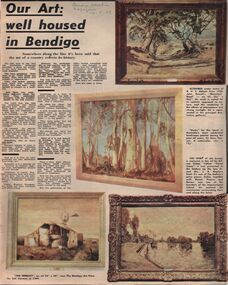
Newspaper - LYDIA CHANCELLOR COLLECTION: 'OUR ART: WELL HOUSED IN BENDIGO.'
... House 11 Mackenzie Street Bendigo goldfields BENDIGO Buildings bendigo art gallery Lydia Chancellor Collection collection Bendigo Bendigo Art Gallery gallery art art work recreation landscapes Australian landscape history R.H.S. Abbott Prize John Rowell 'Mountain Road ' 'Gums ' Sir Hans Heyton Alfred Sisley 'Canal Scene ' Dr. and Mrs. J. A. Neptune Scott Impressionism 'The Derelict ' Sali Herman Bendigo Art Prize Emmeline Pankhurst Victorian Women's Franchise League print photograph porcelain Porcelain Study Design No. 599 W. J. Strauchair 'Bondi 1961 ' William Dobell William Beebe Arthur Boyd 'Pinchin's Farm ' 'The Clearing ' Louis Buvelot George Bell 'Farm Buildings ' Franz Kempf 'Burnt Orange Fern ...A Bendigo Advertiser supplement titled 'Our Art: well housed in Bendigo.' The Education Officer of the Bendigo Art Gallery, Geoff Paynter, gives an insight into some of the acquisitions purchased by, or donated to, the gallery. There is also an article imbedded within this article on 'Woman of the franchise era.' 14/5/1969.bendigo, buildings, bendigo art gallery, lydia chancellor collection, collection, bendigo, bendigo art gallery, gallery, art, art work, recreation, landscapes, australian landscape, history, r.h.s. abbott prize , john rowell, 'mountain road, ' 'gums, ' sir hans heyton, alfred sisley, 'canal scene, ' dr. and mrs. j. a. neptune scott, impressionism, 'the derelict, ' sali herman, bendigo art prize, emmeline pankhurst, victorian women's franchise league, print, photograph, porcelain, porcelain study design no. 599, w. j. strauchair, 'bondi 1961, ' william dobell, william beebe, arthur boyd, 'pinchin's farm, ' 'the clearing, ' louis buvelot, george bell, 'farm buildings, ' franz kempf, 'burnt orange fern at the wind's return, ' 'old bendigo art gallery, ' kenneth jack, 'the digger and his log, ' sir arthur streeton -
 Eltham District Historical Society Inc
Photograph, Slab hut, Warrandyte, Warrandyte Mystery Tour, 29 May 1994, 29/05/1994
... Outside we heard the same bird songs, the trills and bell-pealing, saw the same straggly eucalypts, and a silver leafed wattle in flower, native grasses and ferns, and the neat present day houses, often of Warrandyte stone, perhaps veneered only. ...Outside we heard the same bird songs, the trills and bell-pealing, saw the same straggly eucalypts, and a silver leafed wattle in flower, native grasses and ferns, and the neat present day houses, often of Warrandyte stone, perhaps veneered only. ...[article by Bettina Woodburn in EDHS Newsletter No. 97, July 1994:] THE WARRANDYTE MYSTERY TOUR MAY 29TH 1994 - Members of the Eltham Historical Society met at the Old Post Office, now converted into the Warrandyte Historical Museum, for a picnic lunch on the sunny back verandah overlooking the shimmering Yarra River. Interesting photographs and artefacts filled various rooms outlining the history of this area, and told tales of Aboriginal and more recent neighbours of the Eltham Shire. The weather was calm, cloudy mostly with only occasional sunny patches, but it wasn't cold, although the autumnal leaf colours had changed to wintry brown. "All Aboard" and we set off in the Warrandyte Community Bus (with the School Bus sign displayed at the rear) to learn about local places of "Pride and Joy” from Bruce our guide and Tom the driver. Almost directly opposite we entered Whipstick Gully to explore the first of the district's hidden treasures - the Victory, one of the largest of the six or so major mines, past the old quarry now used for abseiling practice. By torchlight we entered the rocky hillside and saw the seams of quartz the miners had followed in their search for gold. Stamping batteries, and there was one in this gully, converted discarded rock into 'road metal'. Warrandyte is proud to be the first declared Goldfield in 1851, and one of the longest surviving, into the 1920s. A pleasant drive across the Bridge and along Bradley's Lane to Norman's Reserve brought us to see another Tunnel at Pound Bend through which the Yarra was diverted to allow about three miles of river-bed to be used for prospecting for alluvial gold. Still on this side of the river we visited the Old Slab Hut in Castles Road. This remnant of miners' housing is preserved because it had been incorporated into a weatherboard house, and saved from the bulldozers - a last minute reprieve, for preservation, by the National Trust. Devastating bush fires have destroyed other old cottages built of wattle and daub, with bark roofs and stone fire-places. The Cairn commemorating the disclosure of Gold Discovery at Warrandyte on June 30th 1851 beside Anderson's Creek Road was our next point of historical interest. We drove on to South Warrandyte and circled back to above the ford on Anderson's Creek to the entrance of the 4th Hill Mine. Again we crept along with our torches, careful of the low roof-rock, and side shafts. At a junction in a large cavity we were able to stand, look up a long air-vent which some 'cavers' climb down, and marvel at, and experience an aspect of a miner's life. Outside we heard the same bird songs, the trills and bell-pealing, saw the same straggly eucalypts, and a silver leafed wattle in flower, native grasses and ferns, and the neat present day houses, often of Warrandyte stone, perhaps veneered only. The day ended pleasantly, seeing more of the Yarra from Everard Drive, and the water rushing out of the Tunnel at Pound Bend, before returning to afternoon tea or coffee at the Museum. A great day for all concerned - many thanks to the Organisers.Colour photographslab hut, warrandyte, "warrandyte miner's cottage" -
 Eltham District Historical Society Inc
Photograph, Pound Bend tunnel, Warrandyte, Warrandyte Mystery Tour, 29 May 1994, 29/05/1994
... Outside we heard the same bird songs, the trills and bell-pealing, saw the same straggly eucalypts, and a silver leafed wattle in flower, native grasses and ferns, and the neat present day houses, often of Warrandyte stone, perhaps veneered only. ...Outside we heard the same bird songs, the trills and bell-pealing, saw the same straggly eucalypts, and a silver leafed wattle in flower, native grasses and ferns, and the neat present day houses, often of Warrandyte stone, perhaps veneered only. ...[article by Bettina Woodburn in EDHS Newsletter No. 97, July 1994:] THE WARRANDYTE MYSTERY TOUR MAY 29TH 1994 - Members of the Eltham Historical Society met at the Old Post Office, now converted into the Warrandyte Historical Museum, for a picnic lunch on the sunny back verandah overlooking the shimmering Yarra River. Interesting photographs and artefacts filled various rooms outlining the history of this area, and told tales of Aboriginal and more recent neighbours of the Eltham Shire. The weather was calm, cloudy mostly with only occasional sunny patches, but it wasn't cold, although the autumnal leaf colours had changed to wintry brown. "All Aboard" and we set off in the Warrandyte Community Bus (with the School Bus sign displayed at the rear) to learn about local places of "Pride and Joy” from Bruce our guide and Tom the driver. Almost directly opposite we entered Whipstick Gully to explore the first of the district's hidden treasures - the Victory, one of the largest of the six or so major mines, past the old quarry now used for abseiling practice. By torchlight we entered the rocky hillside and saw the seams of quartz the miners had followed in their search for gold. Stamping batteries, and there was one in this gully, converted discarded rock into 'road metal'. Warrandyte is proud to be the first declared Goldfield in 1851, and one of the longest surviving, into the 1920s. A pleasant drive across the Bridge and along Bradley's Lane to Norman's Reserve brought us to see another Tunnel at Pound Bend through which the Yarra was diverted to allow about three miles of river-bed to be used for prospecting for alluvial gold. Still on this side of the river we visited the Old Slab Hut in Castles Road. This remnant of miners' housing is preserved because it had been incorporated into a weatherboard house, and saved from the bulldozers - a last minute reprieve, for preservation, by the National Trust. Devastating bush fires have destroyed other old cottages built of wattle and daub, with bark roofs and stone fire-places. The Cairn commemorating the disclosure of Gold Discovery at Warrandyte on June 30th 1851 beside Anderson's Creek Road was our next point of historical interest. We drove on to South Warrandyte and circled back to above the ford on Anderson's Creek to the entrance of the 4th Hill Mine. Again we crept along with our torches, careful of the low roof-rock, and side shafts. At a junction in a large cavity we were able to stand, look up a long air-vent which some 'cavers' climb down, and marvel at, and experience an aspect of a miner's life. Outside we heard the same bird songs, the trills and bell-pealing, saw the same straggly eucalypts, and a silver leafed wattle in flower, native grasses and ferns, and the neat present day houses, often of Warrandyte stone, perhaps veneered only. The day ended pleasantly, seeing more of the Yarra from Everard Drive, and the water rushing out of the Tunnel at Pound Bend, before returning to afternoon tea or coffee at the Museum. A great day for all concerned - many thanks to the Organisers.Two colour photographswarrandyte, activities, pound bend -
 Eltham District Historical Society Inc
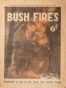
Magazine, Sun News-Pictorial, Bush Fires: A pictorial survey of Victoria's most tragic week, January 8-15, 1939, 1939
... Healewille. with flames visible from the town at one stage, was in a trough between two fires which burned four guest-houses, seven homes and left its surrounding beauty-spots wastes of bowed-over, blackened tree-fern fronds; with its famous Sanctuary, however, intact. ...Healewille. with flames visible from the town at one stage, was in a trough between two fires which burned four guest-houses, seven homes and left its surrounding beauty-spots wastes of bowed-over, blackened tree-fern fronds; with its famous Sanctuary, however, intact. ...THE WEEK REVIEWED (Article; Bush Fires: A pictorial survey of Victoria's most tragic week, January 8-15, 1939. Published in aid of the Bush Fire Relief Fund by the Sun News-Pictorial in co-operation with its newsagents, pp2-3) THE fiercest bush fires Australia has known since its discovery are quiescent at the moment, and Victoria, in the comparative coolness of the change which came with rain on Sunday night, has begun·to count its losses. In the fiery eight days, from Sunday to Sunday, at least sixty-six men, women and children have lost their lives in forest fires, or have succumbed to burns and shock; many others have died from heat; and several serious cases of burns are being treated in hospitals. Two babies in Narrandera district have died, and ten others are in hospital, because of milk soured by the record temperatures of those eight days. Forest damage totals at least a million pounds, and incalculable damage has been done to the seedlings which were to have been the forests of the future. Water conservation will be seriously affected by the silting-up of reservoirs and streams from which protective timber has been taken by the all-engulfing flames. More than a thousand houses have been destroyed, and these, with 40 mills, and schools, post-offices, churches, and other buildings, represent a loss of at least half a million. At least 1500 are homeless. For their aid, money raised in appeals has now passed the £50,000 mark, and the biggest relief organisation ever set up in peace time has swung into operation. The First Hint Victoria's first hint of what was to come appeared on Sunday, January 8, when most parts of the State awoke to find a blistering day awaiting. At 12.20 p.m., when the thermometer reached its highest for the day, 109.6 degrees, the first fire victims were at that moment going to their death on a bush track five feet wide off the main road to Narbethong. They were the forestry officers Charles Isaac Demby and John Hartley Barling, who went to warn Demby of his danger when he parted from his companions, and was himself surrounded by the treacherous fire. It was not until 8 o'clock next morning that the tragic news was flashed throughout the State. Searchers found the two charred bodies close together, one seeking protection in the nook of two logs. Barling's watch had stopped at 1.20. In the meantime, tragedy was spreading its cloak. By Monday, big fires were raging at Toolangi, Erica, Yallourn, Monbulk, Frankston, Dromana, Drouin South, Glenburn, and Blackwood, with smaller outbreaks at many other centres. In the ensuing week, while women and children were evacuated as fast as the flames would permit, Erica-scene of the 1926 fire disaster-thrice escaped doom by a change of wind. Indeed, those who have been in the fire country these past days say that the numbers of times a change of wind has saved towns from destruction is amazing. In the towns they speak of miracles. Monday's Miracles The escapes from Monett's Mill at Erica and from the Hardwood Company's Mill at Murrindindi, near where Demby and Barling went to their death, were Monday's miracles. Twenty came out alive from each mill. At the first a 60ft. dugout provided an oven-like refuge; at the second, 12 women and children survived in the smoke-filled gloom of a three-roomed cottage while their eight men, their clothes sometimes afire, poured water on the wooden walls. Three houses out of ten remained when the fire had passed. Record Temperatures Sunday had been the hottest Melbourne day for 33 years; Monday dropped to a 76.1 degree maximum; but Tuesday dawned hotter than ever, the mercury reaching 112.5. By now rumor was racing ahead of fact; whole towns were being reported lost; the alarm was raised for scores of missing persons. But fact soon overtook rumor, and within a few days the staggering toll began to mount to a figure beyond the wildest imaginings of the panic-stricken. Six died from heat on this torrid Tuesday, and the fires spread in a wide swathe from south-west to north-east across the State. Fish died in shallow streams. A curtain of smoke hid the sky from all Victoria, and hung far out to sea. It alarmed passengers on ships. On the Ormonde, on the voyage to Sydney from Burnie, women ran on deck, believing fire had broken out in the hold. Days later the smoke reached New Zealand. In Melbourne thousands of fire-volunteers were leaving in cars: vans, motor-buses-anything reliable on wheels-to aid the country in its grim fight. In the fires at Rubicon and. Narbethong, seventeen were facing death this day. But not till Wednesday, when Melbourne breathed again in a cool change, while the country still sweltered in temperatures up to 117 degrees, did the news come through the tree blocked roads. A woman and her little daughter, trapped on the road, were among those who died. Their bodies, and those of menfolk with them, were found strewn out at intervals along the road, where the furnace of the surrounding fire had dropped them in their tracks as they ran. Twelve died at a Rubicon mill, five on the road at Narbethong. At Alexandra, not far distant, a baby was born while the fires raged, and stretcher-bearers brought in the injured. On Thursday the State Government voted £5000 for the relief of fire victims. The Governor (Lord Huntingfield) and the Lord Mayor (Cr. Coles) visited some of the stricken areas, and dipped into their pockets personally. Later, the City Council, too, voted £5000. Friday, The 13th Friday, the Thirteenth, justified its evil name. A blistering northerly came early in the morning, presaging destruction, and forcing the mercury to a new record of 114 degrees. Racing fires killed at least ten in those terrible 12 hours. Four children were engulfed in the furnace at Colac. Panic drove them, uncontrollable, into the smoke-filled road when the fire raced down behind their home. They choked to death. In other parts fires were joining to make fronts of scores of miles. Kinglake was being menaced on two fronts, £60,000 worth of timber was going up in smoke in Ballarat district. Warburton was surrounded. Residents at Lorne, favoured resort, were being driven to the sea-front by a fire which destroyed at least 20 homes. Healewille. with flames visible from the town at one stage, was in a trough between two fires which burned four guest-houses, seven homes and left its surrounding beauty-spots wastes of bowed-over, blackened tree-fern fronds; with its famous Sanctuary, however, intact. Most of Omeo was destroyed this black day: Noojee. while 200 residents crouched in the river, was being reduced to a waste of buckled iron and smoking timber; Erica was once again saved by a change of wind. Beneath a pall of smoke, the Rubicon victims were buried at Alexandra. Friday night and the early hours of Saturday saw the streets of beleagured towns strewn with exhausted fire-fighters. Their flails beside them, ready for the next call, they lay where exhaustion overtook them-on footpaths, beside lamp-posts, in gutters, in cars, under trucks. Saturday's dawn brought clear skies and lower temperatures in many parts, and from the burnt-out areas came a great rush of tragic reports. The death-roll rushed past the fifty mark with incredible speed. Some had been trapped on roads, others at mills; some, after burying their treasures, had clung too long to the places they had made their homes for many years. Four men lost their lives because one went back for his dog. By Sunday, when the first of the saving rain came, nearly another score of names had been added to the list.Newspaper magazine, 48 pages (incl. covers). Fully digitised and searchable PDFPublished in aid of the Bush Fire Relief Fund by the Sun News-Pictorial in co-operation with its newsagents.bushfires, 1939 bushfires, black friday, warrandyte -
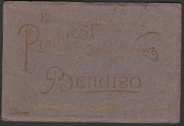 Bendigo Historical Society Inc.
Photograph - Picturesque Colored Views of Bendigo, 1909
... House 11 Mackenzie Street Bendigo goldfields Bendigo Albert Bush Tea Warehouse Book of twelve coloured postcards - "12 Pictures of Colored Views of Bendigo". 1909 calendar printed in gold lettering on rear cover. Brown card cover with gold lettering. Abbott's Bush Stores (Williamson & Mollison Stores) 1909. Next St. Paul's Tower. Includes Post Office Bendigo, Albert Bush's Stores and Tea Warehouse x 2, Bendigo Fernery x 3, Easter Fair Procession, Queen's Monument Camp Reserve, Fern ...Book of twelve coloured postcards - "12 Pictures of Colored Views of Bendigo". 1909 calendar printed in gold lettering on rear cover. Brown card cover with gold lettering. Abbott's Bush Stores (Williamson & Mollison Stores) 1909. Next St. Paul's Tower. Includes Post Office Bendigo, Albert Bush's Stores and Tea Warehouse x 2, Bendigo Fernery x 3, Easter Fair Procession, Queen's Monument Camp Reserve, Fern Pond Camp Reserve, Fountain Charing Cross, Mitchell street, Pall Mall, Town Hall, Hargreaves Street.bendigo, albert bush, tea warehouse -
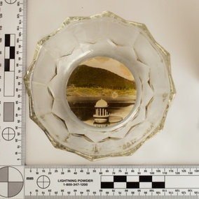 Melbourne Water
Souvenir confectionery bowl, 1930s-40s
... houses and reservoir outlet towers. The reservoir gardens and picnic areas were landscaped with ornamental stonework, exotic trees, decorative flower beds, fern glades pools and rose gardens. ...houses and reservoir outlet towers. The reservoir gardens and picnic areas were landscaped with ornamental stonework, exotic trees, decorative flower beds, fern glades pools and rose gardens. ...Melbourne Water inherited many of its water assets, such as reservoirs from its predecessor the Melbourne Metropolitan Board of Works (MMBW). They have served the organisation well and have long been celebrated for both their natural beauty and engineering ingenuity. In the nineteenth century Victoria’s fundamental need for water infrastructure went beyond merely functional solutions and reflected the English ideal of the romance and beauty that was embodied in expanses of water. The MMBW further enhanced this notion by incorporating beauty and function in to the Classical and Italianate designs of its infrastructure such as pumping houses and reservoir outlet towers. The reservoir gardens and picnic areas were landscaped with ornamental stonework, exotic trees, decorative flower beds, fern glades pools and rose gardens. All features of the water supply system became widely celebrated as beauty spots that continue to be very popular to this day with tourists and locals alike. This souvenir is a product of that flourishing tourist trade. These water supply sites continue to enhance Melbourne’s charm and liveability and are now recognised as places of cultural and historic significance. This souvenir item has been curated by Melbourne Water as it represents an important historical aspect of the organisation by demonstrating the popularity of its water asset sites as recreational places and tourist attractions, and although these sites are functional parts of the water supply system, they were also designed to be enjoyed by the public both aesthetically and recreationally. Clear glass flower shaped 'depression ware' confectionery bowl, with photographic image of Maroondah Reservoir outlet tower on basemelbourne metropolitan board of works, mmbw, maroondah reservoir, melbourne water, scenic view, souvenir, glass bowl -
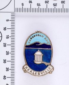 Melbourne Water
Souvenir lapel pin/brooch Maroondah Dam, 1960s/70s
... houses and reservoir outlet towers. The reservoir gardens and picnic areas were landscaped with ornamental stonework, exotic trees, decorative flower beds, fern glads pools and rose gardens. ...houses and reservoir outlet towers. The reservoir gardens and picnic areas were landscaped with ornamental stonework, exotic trees, decorative flower beds, fern glads pools and rose gardens. ...Melbourne Water inherited many of its water assets, such as reservoirs from its predecessor the Melbourne Metropolitan Board of Works (MMBW). They have served the organisation well and have long been celebrated for both their natural beauty and engineering ingenuity. In the nineteenth century Victoria’s fundamental need for water infrastructure went beyond merely functional solutions and reflected the English ideal of the romance and beauty that was embodied in expanses of water. The MMBW further enhanced this notion by incorporating beauty and function in to the Classical and Italianate designs of its infrastructure such as pumping houses and reservoir outlet towers. The reservoir gardens and picnic areas were landscaped with ornamental stonework, exotic trees, decorative flower beds, fern glads pools and rose gardens. All features of the water supply system became widely celebrated as beauty spots that continue to be very popular to this day with tourists and locals alike. This souvenir is a product of that flourishing tourist trade. These water supply sites continue to enhance Melbourne’s charm and liveability and are now recognised as places of cultural and historic significance. This souvenir item has been curated by Melbourne Water as it represents an important historical aspect of the organisation by demonstrating the popularity of its water asset sites as recreational places and tourist attractions, and although these sites are functional parts of the water supply system, they were also designed to be enjoyed by the public both aesthetically and recreationally. Blue enamel and metal lapel pin/brooch depicting Maroondah Reservoir and outlet tower. Oval shaped with words 'Maroondah Dam' at the top and a ribbon banner containing 'Healesville' at the bottom. Maroondah Dam. Healesvillemelbourne metropolitan board of works, mmbw, maroondah reservoir, melbourne water, scenic view, souvenir, lapel pin, brooch -
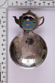 Melbourne Water
Souvenir tea caddy spoon "Tea Time", Early 1960s
... houses and reservoir outlet towers. The reservoir gardens and picnic areas were landscaped with ornamental stonework, exotic trees, decorative flower beds, fern glads pools and rose gardens. ...houses and reservoir outlet towers. The reservoir gardens and picnic areas were landscaped with ornamental stonework, exotic trees, decorative flower beds, fern glads pools and rose gardens. ...Melbourne Water inherited many of its water assets, such as reservoirs from its predecessor the Melbourne Metropolitan Board of Works (MMBW). They have served the organisation well and have long been celebrated for both their natural beauty and engineering ingenuity. In the nineteenth century Victoria’s fundamental need for water infrastructure went beyond merely functional solutions and reflected the English ideal of the romance and beauty that was embodied in expanses of water. The MMBW further enhanced this notion by incorporating beauty and function in to the Classical and Italianate designs of its infrastructure such as pumping houses and reservoir outlet towers. The reservoir gardens and picnic areas were landscaped with ornamental stonework, exotic trees, decorative flower beds, fern glads pools and rose gardens. All features of the water supply system became widely celebrated as beauty spots that continue to be very popular to this day with tourists and locals alike. This souvenir is a product of that flourishing tourist trade. These water supply sites continue to enhance Melbourne’s charm and liveability and are now recognised as places of cultural and historic significance This souvenir item has been curated by Melbourne Water as it represents an important historical aspect of the organisation by demonstrating the popularity of its water asset sites as recreational places and tourist attractions, and although these sites are functional parts of the water supply system, they were also designed to be enjoyed by the public both aesthetically and recreationally. Tea caddy spoon with clock face engraved showing 4pm on round spoon, tea pot shaped handle with enamel scenic view badge saying 'Healesville' ( depicting Maroondah Reservoir outlet tower). Tea caddy spoon box labelled 'Fine Silverware by Stokes'Stokes and Sons Stokes & Sons logo (Star with S and boomerang) EG. No. 15733melbourne metropolitan board of works, mmbw, maroondah reservoir, melbourne water, scenic view, souvenir, tea caddy spoon -
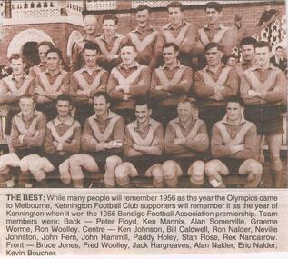 Bendigo Historical Society Inc.
Newspaper - JENNY FOLEY COLLECTION: THE BEST
... House 11 Mackenzie Street Bendigo goldfields NEWSPAPER Bendigo advertiser the way we were Bendigo Advertiser "The way we were" from Saturday, November 13, 2004. The best: while many people will remember 1956 as the year the Olympics came to Melbourne, Kennington Football Club supporters will rememberit as the year of Kennington winning the Bendigo Football Association premiership. Team members were: Back - Peter Floyd, Ken Mannix, Alan Somerville, Graeme Worme, Ron Woolley. Centre - Ken Johnson, Bill Caldwell, Ron Nalder, Neville Johnston, John Fern ...Bendigo Advertiser "The way we were" from Saturday, November 13, 2004. The best: while many people will remember 1956 as the year the Olympics came to Melbourne, Kennington Football Club supporters will rememberit as the year of Kennington winning the Bendigo Football Association premiership. Team members were: Back - Peter Floyd, Ken Mannix, Alan Somerville, Graeme Worme, Ron Woolley. Centre - Ken Johnson, Bill Caldwell, Ron Nalder, Neville Johnston, John Fern, John Hammill, Paddy Holey, Stan Rose, Rex Nancarrow. Front - Bruce Jones, Fred Woolley, Jack Hargreave, Alan Nakler, Eric Nalder, Kevin Boucher.newspaper, bendigo advertiser, the way we were -
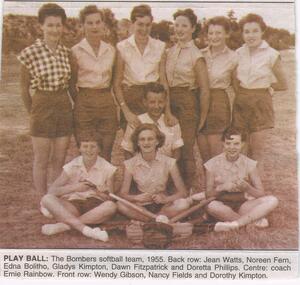 Bendigo Historical Society Inc.
Newspaper - JENNY FOLEY COLLECTION: PLAY BALL
... History House 11 Mackenzie Street Bendigo goldfields NEWSPAPER Bendigo advertiser the way we were Bendigo Advertiser "The way we were" from Thursday, May 27, 2004. Play ball: the Bombers softball team, 1955. Back row: Jean Watts, Noreen Fern ...Bendigo Advertiser "The way we were" from Thursday, May 27, 2004. Play ball: the Bombers softball team, 1955. Back row: Jean Watts, Noreen Fern, Edna Bolitho, Gladys Kimpton, Dawn Fitzpatrick and Doretta Phillips. Centre: coach Ernie Rainbow. Front row: Wendy Gibson, Nancy Fields and Dorothy Kimpton.newspaper, bendigo advertiser, the way we were -
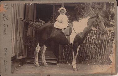 Bendigo Historical Society Inc.
Photograph - LYDIA CHANCELLOR COLLECTION; A CHILD ON A PONY
... History House 11 Mackenzie Street Bendigo goldfields PHOTOGRAPH Person child and horse Lydia Chancellor Collection collection photography photograph photo child children horse animals animal costume fashion clothing A hard backed black and white photograph of a child on a pony. The horse has a white mane and white legs. The child is formally dressed including a bonnet. In the background is a gate, front door entrance and stick fence. Behind the fence are ferns ...A hard backed black and white photograph of a child on a pony. The horse has a white mane and white legs. The child is formally dressed including a bonnet. In the background is a gate, front door entrance and stick fence. Behind the fence are ferns and other plants. The photographer is ? H. Smith, Photo., Kyneton.photograph, person, child and horse, lydia chancellor collection, collection, photography, photograph, photo, child, children, horse, animals, animal, costume, fashion, clothing -
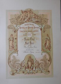 Bendigo Historical Society Inc.
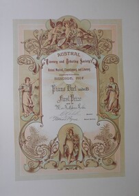
Document - FOSTER AND WILSON COLLECTION: CERTIFICATE AUSTRAL LITERARY AND DEBATING SOCIETY, 1907
... History House 11 Mackenzie Street Bendigo goldfields DOCUMENT Certificate music Austral Literary and Debating Society Certificate from Austral Literary and Debating Society's Annual Musical Elocutionary & Literary Competitions in Bendigo 1907. Certificate is printed on thick cream cardboard. A wide plain border surrounds a coloured ornate certificate of mainly pink and green. Decoration is of cherubs and muses, fleur de lys, scrollwork and ferns ...Certificate from Austral Literary and Debating Society's Annual Musical Elocutionary & Literary Competitions in Bendigo 1907. Certificate is printed on thick cream cardboard. A wide plain border surrounds a coloured ornate certificate of mainly pink and green. Decoration is of cherubs and muses, fleur de lys, scrollwork and ferns. Certificate for First Prize was awarded for Piano Duet and was won by Miss Kathleen Foster. Certificate is signed by President E S Cahill and General Secretary Thomas Byrne.Austral Literary and Debating Societydocument, certificate, music -
 Bendigo Historical Society Inc.
Document - FOSTER AND WILSON COLLECTION: CERTIFICATE AUSTRAL LITERARY AND DEBATING SOCIETY, 1907
... History House 11 Mackenzie Street Bendigo goldfields DOCUMENT Certificate music Austral Literary and Debating Society Certificate from Austral Literary and Debating Society's Annual Musical Elocutionary & Literary Competitions in Bendigo 1907. Certificate is printed on thick cream cardboard. A wide plain border surrounds a coloured ornate certificate of mainly pink and green. Decoration is of cherubs and muses, fleur de lys, scrollwork and ferns ...Certificate from Austral Literary and Debating Society's Annual Musical Elocutionary & Literary Competitions in Bendigo 1907. Certificate is printed on thick cream cardboard. A wide plain border surrounds a coloured ornate certificate of mainly pink and green. Decoration is of cherubs and muses, fleur de lys, scrollwork and ferns. Certificate for First Prize was awarded for Piano Duet Under 18 and was won by Miss Kathleen Foster. Certificate is signed by President E S Cahill and General Secretary Thomas Byrne.Austral Literary and Debating Societydocument, certificate, music -
 Bendigo Historical Society Inc.
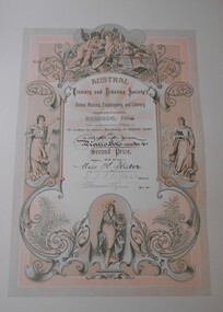
Document - FOSTER AND WILSON COLLECTION: CERTIFICATE AUSTRAL LITERARY AND DEBATING SOCIETY, 1906
... History House 11 Mackenzie Street Bendigo goldfields DOCUMENT Certificate music Austral Literary and Debating Society Certificate from Austral Literary and Debating Society's Annual Musical Elocutionary & Literary Competitions in Bendigo 1906. Certificate is printed on thick cream cardboard. A wide plain border surrounds a coloured ornate certificate of mainly pink and green. Decoration is of cherubs and muses, fleur de lys, scrollwork and ferns ...Certificate from Austral Literary and Debating Society's Annual Musical Elocutionary & Literary Competitions in Bendigo 1906. Certificate is printed on thick cream cardboard. A wide plain border surrounds a coloured ornate certificate of mainly pink and green. Decoration is of cherubs and muses, fleur de lys, scrollwork and ferns. Certificate for Second Prize was awarded for Piano Solo Under 16 and was won by Miss Kathleen Foster. Certificate is signed by President E J Vigau? and General Secretary Thomas Byrne.Austral Literary and Debating Societydocument, certificate, music