Showing 365 items matching "footbridge"
-
 Lakes Entrance Historical Society
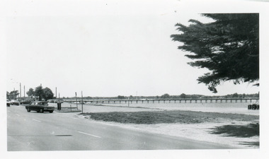
Photograph - Footbridge, footbridge and Princes Highway Lakes Entrance Victoria, 1990c
... Footbridge...footbridge and Princes Highway Lakes Entrance Victoria...Small format, black and white photograph of the footbridge and Princes Highway. It shows cars parked beside the road, footbridge, lake, and part of a WW1 memorial cypress tree in foreground. ...Lakes Entrance Victoria footbridge and Princes Highway Lakes Entrance Victoria Photograph Footbridge ...Small format, black and white photograph of the footbridge and Princes Highway. It shows cars parked beside the road, footbridge, lake, and part of a WW1 memorial cypress tree in foreground. Lakes Entrance Victoria waterfront, foreshore -
 Lakes Entrance Historical Society
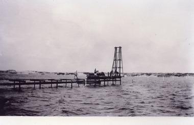
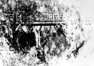
Photograph - Footbridge, Jemmeson Edie, Footbridge construction . Lakes Entrance Victoria, 1936
... Footbridge...Footbridge construction . Lakes Entrance Victoria...Black and white photograph of the first section of the footbridge being constructed across the Cunninghame Arm, it shows work underway. ...Lakes Entrance Victoria Footbridge construction . Lakes Entrance Victoria Photograph Footbridge Jemmeson Edie ...One other copyBlack and white photograph of the first section of the footbridge being constructed across the Cunninghame Arm, it shows work underway. Pile driver at end of partly constructed bridge. Lakes Entrance Victoriabridges, waterways -
 Lakes Entrance Historical Society
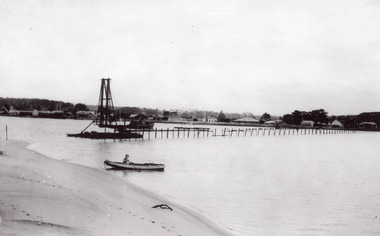
Photograph - Footbridge, Jemmeson Edie, Footbridge construction, Lakes Entrance Victoria, 1936
... Footbridge.... Footbridge construction, Lakes Entrance Victoria...Black and white photograph of the incomplete footbridge over Cunninghame Arm. It shows the incomplete bridge almost at the south shore, and a view of town waterfront from Eastern Wharf to Myer Street corner. ...Lakes Entrance Victoria . Footbridge construction, Lakes Entrance Victoria Photograph Footbridge Jemmeson Edie ...Also second copyBlack and white photograph of the incomplete footbridge over Cunninghame Arm. It shows the incomplete bridge almost at the south shore, and a view of town waterfront from Eastern Wharf to Myer Street corner. Man in rowboat almost on beach in foreground. Lakes Entrance Victoriawaterfront, bridges, room display, construction -
 Lakes Entrance Historical Society
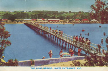
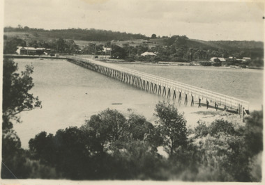
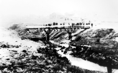
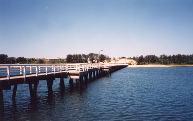
Photograph - Cunninghame Arm footbridge Lakes Entrance Victoria. c1955, Rose Series, 1955 c
... Cunninghame Arm footbridge Lakes Entrance Victoria. c1955....Cunninghame Arm footbridge showing crowd on bridge, cars parked on Esplanade, new concrete wall between dunes and lake at south end of bridge Lakes Entrance Victoria. ...Also another colour postcard similar view of footbridge ...Also another colour postcard similar view of footbridge Cunninghame Arm footbridge Lakes Entrance Victoria. c1955. ...Cunninghame Arm footbridge showing crowd on bridge, cars parked on Esplanade, new concrete wall between dunes and lake at south end of bridge Lakes Entrance Victoria. c1955. Also another colour postcard similar view of footbridge made by Murray Views donor Susan Samuel 2 January 2015 number 04272.1, 9 x 14 cmColour postcard taken from south end of the Cunninghame Arm footbridge showing crowd on bridge, cars parked on Esplanade, new concrete wall between dunes and lake at south end of bridge Lakes Entrance Victoria. c1955. Also another colour postcard similar view of footbridge The Foot-Bridge, Lakes Entrance. Vicrecreation, waterfront, land reclamation, gippsland lakes -
 Lakes Entrance Historical Society
Postcard - Cunninghame Arm footbridge Lakes Entrance Victoria, H D Bulmer, 1940
... Cunninghame Arm footbridge Lakes Entrance Victoria ...Also two black and white postcards looking across footbridge to township 04271.1, 04271.2 size 9.5 x 14 cm 1940 c...Also two black and white postcards looking across footbridge to township 04271.1, 04271.2 size 9.5 x 14 cm 1940 c...Also two black and white postcards looking across footbridge to township 04271.1, 04271.2 size 9.5 x 14 cm 1940 c Cunninghame Arm footbridge Lakes Entrance Victoria Postcard Cunninghame Arm footbridge Lakes Entrance Victoria H D Bulmer ...Also two black and white postcards looking across footbridge to township 04271.1, 04271.2 size 9.5 x 14 cm 1940 cBlack and white postcard of Cunninghame Arm footbridge taken from the top of the sand dunes looking towards the few houses of Lakes Entrance Victoria Stamp on back The Lakes Studio Lakes Entrance. Also two black and white postcards looking across footbridge to township 04271.1, 04271.2 size 9.5 x 14 cm 1940 cbridges, recreational facilities, surf lifesaving, waterfront -
 Eltham District Historical Society Inc
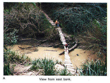
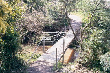
Work on paper (Sub-Item) - Photograph, Home-made footbridge across Diamond Creek, opposite Gum Glade, Eltham
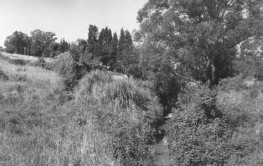
... Home-made footbridge across Diamond Creek, opposite Gum Glade, Eltham......footbridge...Colour photograph of home-made footbridge across the Diamond Creek opposite Gum Glade, Eltham. ...View from east bank. eltham diamond creek footbridge gum glade Image printed on A4 page from 04997 Diamond Creek Basin Study, 1980 Home-made footbridge across Diamond Creek, opposite Gum Glade, Eltham Work on paper Photograph ...Colour photograph of home-made footbridge across the Diamond Creek opposite Gum Glade, Eltham. View from east bank.eltham, diamond creek, footbridge, gum glade -
 Mt Dandenong & District Historical Society Inc.
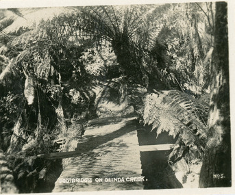
Photograph, Footbridge On Olinda Creek, late 1930s
... Footbridge On Olinda Creek.......footbridge...Small photograph, number 3 in Olinda series, showing footbridge over Olinda Creek surrounded by tree ferns. ...Late 1930s. Footbridge On Olinda Creek. Photograph ...Number 3 in commercial series.Small photograph, number 3 in Olinda series, showing footbridge over Olinda Creek surrounded by tree ferns. Late 1930s.olinda creek, footbridge, bridge, olinda, creek, tree ferns, ferns, bush -
 Buninyong & District Historical Society
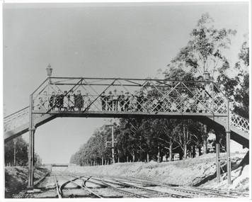
Photograph - Photo of Original Photograph, D. Macartney, B/W photo of footbridge over Buninyong Junction, in 1892 or 1897, 1995
... B/W photo of footbridge over Buninyong Junction, in 1892 or 1897......Footbridge...Photo B/W of footbridge, lined with children, linking Dyte's Parade and Scott's Parade to Queen St. ...Buninyong Railway Bunny Bridge Footbridge Photo B/W of footbridge, lined with children, linking Dyte's Parade and Scott's Parade to Queen St. ...Railway station and surrounds in 1940.Photo B/W of footbridge, lined with children, linking Dyte's Parade and Scott's Parade to Queen St. Ballarat. Bridge in distance shows the junction of the Buninyong Line near Ballarat East, known as Buninyong Junction. Taken 1892 or 1897.buninyong, railway, bunny, bridge, footbridge -
 Surrey Hills Historical Society Collection
Photograph, Footbridge across Back Creek, 1980, 1980
... Footbridge across Back Creek, 1980...The family sold the land to the Camberwell Council in the 1950s. The original footbridge was opened by Sir Winston Dugan in 1936....Black and white photo of a wooden footbridge with large trees and shrubs obscuring its surrounds....Footbridge across Back Creek, 1980 Photograph Photograph ...South Surrey Park was developed on land which had been the property of the Kleinert family. Their land extended from Union Road to Essex Road. They ran horses, ducks and fowls and Emily Kleinert grew flowers. Alan Holt research: Lot 6 was sold to Martin Klienert by Karl Richter in 1860 together with a portion of another adjacent lot. From 1860-1885 Martin worked it as a market garden leasing some land for grazing when it was not required for gardening. He died in 1898. In a formal document, William declared he was the son of Martin "who purchased land in 1860, died in 1898 and the land has been continually occupied by father and family since. It has been cultivated as a market garden; when not being used for gardening it was let for cultivation and grazing." William died in 1939 and the property passed to his sons Martin and Ernest. The family sold the land to the Camberwell Council in the 1950s. The original footbridge was opened by Sir Winston Dugan in 1936.Black and white photo of a wooden footbridge with large trees and shrubs obscuring its surrounds.parks and reserves, creeks, south surrey park, back creek, verdun street, footbridges -
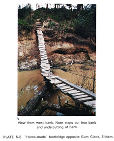 Eltham District Historical Society Inc
Work on paper (Sub-Item) - Photograph, Home-made footbridge across Diamond Creek, opposite Gum Glade, Eltham
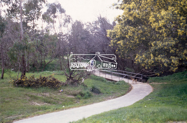
... Home-made footbridge across Diamond Creek, opposite Gum Glade, Eltham......footbridge...Colour photograph of home-made footbridge across the Diamond Creek opposite Gum Glade, Eltham. ...Eltham District Historical Society Inc 728 Main Rd Eltham melbourne Colour photograph of home-made footbridge across the Diamond Creek opposite Gum Glade, Eltham. ...Colour photograph of home-made footbridge across the Diamond Creek opposite Gum Glade, Eltham. View from west bank. Note steps cut into bank and undercutting of bankeltham, diamond creek, footbridge, gum glade, creek bank -
 Surrey Hills Historical Society Collection
Photograph, Opening of the footbridge across Back Creek, 1936, 1936
... Opening of the footbridge across Back Creek, 1936...This photo was taken at the opening of the footbridge over Back Creek by Sir Winston Dugan, Governor of Victoria, in 1936. ...Black and white photo taken at the opening of the footbridge across Back Creek in the area later known as South Surrey Park. ...Opening of the footbridge across Back Creek, 1936 Photograph Photograph Ken Hall ...This photo was taken at the opening of the footbridge over Back Creek by Sir Winston Dugan, Governor of Victoria, in 1936. He is cutting bunting draped along the bridge rails. South Surrey Park was developed on land which had been the property of the Kleinert family. Their land extended from Union Road to Essex Road. They ran horses, ducks and fowls and Emily Kleinert grew flowers. Alan Holt research: Lot 6 was sold to Martin Klienert by Karl Richter in 1860 together with a portion of another adjacent lot. From 1860-1885 Martin worked it as a market garden leasing some land for grazing when it was not required for gardening. He died in 1898. In a formal document, William declared he was the son of Martin "who purchased land in 1860, died in 1898 and the land has been continually occupied by father and family since. It has been cultivated as a market garden; when not being used for gardening it was let for cultivation and grazing." William died in 1939 and the property passed to his sons Martin and Ernest. The family sold the land to the Camberwell Council in the 1950s.This photo is significant as it documents the change from rural to urban land use in the area.Black and white photo taken at the opening of the footbridge across Back Creek in the area later known as South Surrey Park. Back Creek runs diagonally through the photo with a wooden footbridge prominent. Dignitaries are gathered on the bridge. A tent and houses can just be distinguished in the background.parks and reserves, creeks, south surrey park, civic occasion, official events, back creek, verdun street, footbridges, governor of victoria, sir winston duggan, surrey hills, kleinert family, (mr) karl richter, (mr) martin kleinert, topography -
 Lakes Entrance Historical Society
Photograph, Lakes Post Newspaper, Cunninghame Arm Footbridge, . Lakes Entrance, 1999
... Cunninghame Arm Footbridge, . Lakes Entrance...Colour photograph of the Cunninghame Arm Footbridge, . Lakes Entrance...Lakes Entrance Historical Society 4 Marine Parade Lakes Entrance gippsland Bridges Waterways Associations Topography Colour photograph of the Cunninghame Arm Footbridge, . Lakes Entrance Cunninghame Arm Footbridge, . ...Colour photograph of the Cunninghame Arm Footbridge, . Lakes Entrancebridges, waterways, associations, topography -
 Eltham District Historical Society Inc
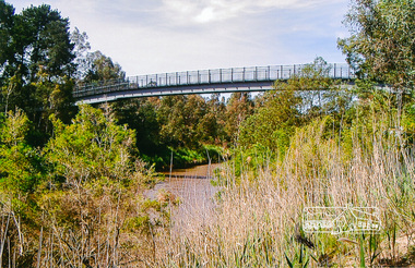
Photograph, Footbridge across the Yarra River at Eltham Lower Park
... Footbridge across the Yarra River at Eltham Lower Park......footbridge...The Yarra River Footbridge was opened in August 2004 and links the Diamond Creek Trail between the Shire of Nillumbik and City of Manningham. ...It affords lovely views over the Yarra River. bridge eltham lower park eltham south homestead road lenister farm yarra river footbridge lookout diamond creek trail Colour photograph Footbridge across the Yarra River at Eltham Lower Park Photograph Photograph ...The Yarra River Footbridge was opened in August 2004 and links the Diamond Creek Trail between the Shire of Nillumbik and City of Manningham. It is a shared pathway and also links with the Main Yarra Trail. It affords lovely views over the Yarra River.Colour photographbridge, eltham lower park, eltham south, homestead road, lenister farm, yarra river, footbridge, lookout, diamond creek trail -
 Eltham District Historical Society Inc
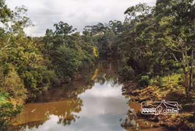
Photograph, Doug Orford, Yarra River from Eltham-Templestowe Footbridge, 2004, 2004
... Yarra River from Eltham-Templestowe Footbridge, 2004...Two colour photographs of Yarra River upstream and downstream from Eltham-Templestowe footbridge...Eltham District Historical Society Inc 728 Main Rd Eltham melbourne yarra river bridges eltham eltham south templestowe eltham lower park lenister farm Two colour photographs of Yarra River upstream and downstream from Eltham-Templestowe footbridge Yarra River from Eltham-Templestowe Footbridge, 2004 Photograph Doug Orford ...Two colour photographs of Yarra River upstream and downstream from Eltham-Templestowe footbridgeyarra river, bridges, eltham, eltham south, templestowe, eltham lower park, lenister farm -
 Whitehorse Historical Society Inc.
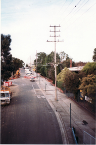
Photograph, Footbridge Whitehorse Road, 1/06/1999 12:00:00 AM
... Footbridge Whitehorse Road...Coloured photo - From Footbridge in Whitehorse Road, Mitcham, looking towards Mitcham Road....Footbridge Whitehorse Road Photograph Photograph ...Coloured photo - From Footbridge in Whitehorse Road, Mitcham, looking towards Mitcham Road.whitehorse road, overhead powerlines -
 Whitehorse Historical Society Inc.
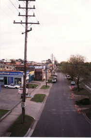
Photograph, Whitehorse Road Footbridge, 1/06/1999 12:00:00 AM
... Whitehorse Road Footbridge...Coloured photo - From Whitehorse Road Footbridge in Mitcham, looking towards Rooks Road....Whitehorse Road Footbridge Photograph Photograph ...Coloured photo - From Whitehorse Road Footbridge in Mitcham, looking towards Rooks Road.whitehorse road, overhead powerlines -
Lakes Entrance Historical Society
Book, Fenner-Bailey, Mia, Lakes Entrance Footbridge, 2002
... Lakes Entrance Footbridge...Research, interpretation and management recommendations for the Lakes Entrance Footbridge, Lakes Entrance, East Gippsland, Victoria...Lakes Entrance Historical Society 4 Marine Parade Lakes Entrance gippsland Bridges Tourism Research, interpretation and management recommendations for the Lakes Entrance Footbridge, Lakes Entrance, East Gippsland, Victoria Lakes Entrance Footbridge Book Fenner-Bailey, Mia ...Research, interpretation and management recommendations for the Lakes Entrance Footbridge, Lakes Entrance, East Gippsland, Victoriabridges, tourism -
 Whitehorse Historical Society Inc.
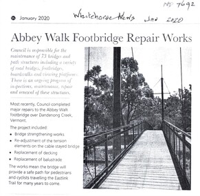
Article, Abbey Walk Footbridge Repairs, Jan 2020
... Abbey Walk Footbridge Repairs...Abbey Walk footbridge has been repaired as part of the Whitehorse Council's regular maintenance program....Abbey Walk Footbridge Repairs Article Article Whitehorse News ...Abbey Walk footbridge has been repaired.Abbey Walk footbridge has been repaired as part of the Whitehorse Council's regular maintenance program.Abbey Walk footbridge has been repaired. abbey walk vermont, footpaths, bridges, east link, city of whitehorse, dandenong creek vermont -
 Eltham District Historical Society Inc
Photograph, Fay Bridge, Footbridge, Fort Knox Self Storage, 197 Sherbourne Road, Eltham, n.d
... Footbridge, Fort Knox Self Storage, 197 Sherbourne Road, Eltham ......Footbridge...The footbridge which extended from the facility to the landscaped garden and water features is now gone. ...Eltham District Historical Society Inc 728 Main Rd Eltham melbourne The footbridge which extended from the facility to the landscaped garden and water features is now gone. ...The footbridge which extended from the facility to the landscaped garden and water features is now gone. The footbridge and garden were previously part of a former hat factory in Sherbourne Road Eltham which has in the past been used for various purposes and presently a self storage business. The Karingal Yallock Creek passes through the front of the land and the creek environs are the subject of significant and unusual landscaping works, including some cascading water channels. Some of the landscaping was damaged by the Christmas Day floods of 2011, but the main elements remain intact. The landscaped area (as distinct from the factory itself) is the subject of a Heritage Overlay under the Nillumbik Planning Scheme. The basis of this overlay is a Heritage Report by Graeme Butler and Associates in 2006. As well as an assessment of the landscaped area, it includes one background information on the history of the site (although a complete history would require more research). The site was part of Crown Portion 3 of the Parish of Nillumbik that remained as the Montmorency Farm until early in the twentieth century. The 1911 subdivision of this farm created Lot 7 of some seven acres, which is the site of this factory. The Heritage Report lists the various owners of the site. From the rate records and aerial photos it is concluded that the site was used as an orchard and farmland until the 1940s. William F Crellin, orchardist, owned the site from 1912 to 1923. Then Edmund Williams owned it until 1951. In 1955 the site was owned by Rupert V. Kirsch and this is the name anecdotally associated with the hat factory, where the well-known brand of Fayrefield Hats were manufactured. There is some belief that this was built about the time of the Second World War and that hats for the armed forces were made there.fay bridge collection, eltham, fayrefield hat factory, foot bridge, sherbourne road, footbridge, fort knox eltham -
 Eltham District Historical Society Inc
Slide - Photograph, Footbridge, Montmorency Park, c.Sep. 1989
... Footbridge, Montmorency Park...footbridge...The presentation included slides of historic photos from the Shire of Eltham Pioneers collections as well as several recent views. footbridge montmorency park 35mm colour positive transparency (1 of 15) Mount - Agfa CS System grey 8 dots Footbridge, Montmorency Park Slide Photograph ...Part of a slide show presentation "Bridges & Waterways of the Shire" by Russell Yeoman to the 13 September 1989 Society meeting. The presentation included slides of historic photos from the Shire of Eltham Pioneers collections as well as several recent views.35mm colour positive transparency (1 of 15) Mount - Agfa CS System grey 8 dotsfootbridge, montmorency park -
 Eltham District Historical Society Inc
Slide - Photograph, Footbridge, Montmorency Park, c.Sep. 1989
... Footbridge, Montmorency Park...Footbridge...The presentation included slides of historic photos from the Shire of Eltham Pioneers collections as well as several recent views. Footbridge Montmorency Park 35mm colour positive transparency (1 of 15) Mount - Agfa CS System grey 8 dots Footbridge, Montmorency Park Slide Photograph ...Part of a slide show presentation "Bridges & Waterways of the Shire" by Russell Yeoman to the 13 September 1989 Society meeting. The presentation included slides of historic photos from the Shire of Eltham Pioneers collections as well as several recent views.35mm colour positive transparency (1 of 15) Mount - Agfa CS System grey 8 dotsfootbridge, montmorency park -
 Ringwood and District Historical Society
Photograph, Mullum Creek from footbridge on Munro St., Ringwood, looking east - 1969, 1970
... Mullum Creek from footbridge on Munro St., Ringwood, looking east - 1969....Written on rear of backing sheet: "Mullum Creek looking east at footbridge at Munro St. 1969. Pampas grass was planted years ago by Mrs. ...Written on rear of backing sheet: "Mullum Creek looking east at footbridge at Munro St. 1969. Pampas grass was planted years ago by Mrs. ...Black and white photographWritten on rear of backing sheet: "Mullum Creek looking east at footbridge at Munro St. 1969. Pampas grass was planted years ago by Mrs. Brown." -
 Whitehorse Historical Society Inc.
Article, Burwood Link footbridge, 2017
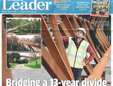
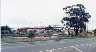
... Burwood Link footbridge...Work finally begins on the 245 m Burwood Link footbridge connecting Deakin University's two main study areas after 13 years of dispute....Burwood Link footbridge Article Article ...Work finally begins on the 245 m Burwood Link footbridge connecting Deakin University's two main study areas after 13 years of dispute.deakin university burwood campus -
 Stawell Historical Society Inc
Photograph, Stawell Railway Footbridge 1991 -- Coloured
... Stawell Railway Footbridge 1991 -- Coloured ...Footbridge to East of Stawell Railway Station...Stawell Historical Society Inc 46 Longfield St Stawell grampians Footbridge to East of Stawell Railway Station Transport Railways Stawell Railway Footbridge 1991 -- Coloured Photograph ...Footbridge to East of Stawell Railway Stationtransport, railways -
 Stawell Historical Society Inc
Photograph, Wooden Footbridge over the river in Glenorchy
... Wooden Footbridge over the river in Glenorchy...Glenorchy Wooden Footbridge over River...Stawell Historical Society Inc 46 Longfield St Stawell grampians Glenorchy Wooden Footbridge over River Stawell Wooden Footbridge over the river in Glenorchy Photograph ...Glenorchy Wooden Footbridge over Riverstawell -
 Lakes Entrance Historical Society
Photograph, Cunninghame Arm Footbridge, Lakes Entrance Victoria, 1999
... Cunninghame Arm Footbridge, Lakes Entrance Victoria...Colour photograph of the Cunninghame Arm Footbridge, showing the excavation of sand after removal of Kiosk, prior to construction of new Surf Lifesaving Clubrooms. ...Lakes Entrance Victoria Cunninghame Arm Footbridge, Lakes Entrance Victoria Photograph ...Colour photograph of the Cunninghame Arm Footbridge, showing the excavation of sand after removal of Kiosk, prior to construction of new Surf Lifesaving Clubrooms. Lakes Entrance Victoriabridges, waterways, construction -
 Greensborough Historical Society
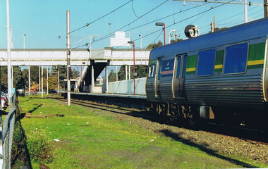
Photograph - Digital image, Frank Solomon, Greensborough Station looking toward the footbridge overpass, 1990c
... Greensborough Station looking toward the footbridge overpass....The Greensborough Station looking toward the footbridge overpass....Greensborough Historical Society 34A Glenauburn Road Lower Plenty Lower Plenty melbourne The Greensborough Station looking toward the footbridge overpass. greensborough station Digital copy of colour photograph Greensborough Station looking toward the footbridge overpass. ...The Greensborough Station looking toward the footbridge overpass.Digital copy of colour photographgreensborough station -
 Eltham District Historical Society Inc
Slide - Photograph, Footbridge, George Court, Greensborough, c.Sep. 1989
... Footbridge, George Court, Greensborough...Footbridge...The presentation included slides of historic photos from the Shire of Eltham Pioneers collections as well as several recent views. Footbridge George Court Greensborough 35mm colour positive transparency (1 of 15) Mount - Agfa CS System grey 8 dots Footbridge, George Court, Greensborough Slide Photograph ...Part of a slide show presentation "Bridges & Waterways of the Shire" by Russell Yeoman to the 13 September 1989 Society meeting. The presentation included slides of historic photos from the Shire of Eltham Pioneers collections as well as several recent views.35mm colour positive transparency (1 of 15) Mount - Agfa CS System grey 8 dotsfootbridge, george court, greensborough -
 Eltham District Historical Society Inc
Slide - Photograph, Footbridge near Brougham Street, Eltham, c.Sep. 1989
... Footbridge near Brougham Street, Eltham......Footbridge...The presentation included slides of historic photos from the Shire of Eltham Pioneers collections as well as several recent views. brougham street bridge eltham Footbridge 35mm colour positive transparency (1 of 15) Mount - Agfa CS System grey 8 dots Footbridge near Brougham Street, Eltham Slide Photograph ...Part of a slide show presentation "Bridges & Waterways of the Shire" by Russell Yeoman to the 13 September 1989 Society meeting. The presentation included slides of historic photos from the Shire of Eltham Pioneers collections as well as several recent views.35mm colour positive transparency (1 of 15) Mount - Agfa CS System grey 8 dotsbrougham street bridge, eltham, footbridge