Showing 47 items matching "forest measurement"
-
 Department of Energy, Environment and Climate Action
FCV measuring band
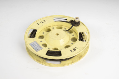
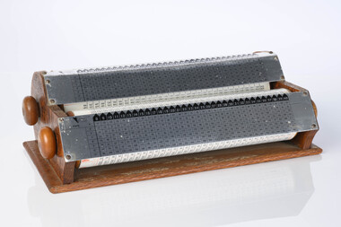
... ...Forest measurement...Forests Commission Victoria (FCV) assessment Forest measurement Surveying mapping FCV 281 Steel measuring band (50m) on plastic reel with winding handle FCV measuring band ...Used for measuring distances in the forest. Steel bands (out of tradition were called the chain) were created around 1890. They replaced the traditional Gunter chain. The band could be repaired by soldering slip-on joiners and than and recalibrating.Steel measuring band (50m) on plastic reel with winding handleFCV 281forests commission victoria (fcv), assessment, forest measurement, surveying, mapping -
 Department of Energy, Environment and Climate Action
FCV measuring band
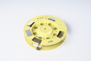
... ...Forest measurement...Forests Commission Victoria (FCV) assessment Forest measurement Surveying mapping FCV 188 Steel measuring band (50m) on plastic reel with winding handle missing FCV measuring band ...Used for measuring distances in the forest. Steel bands (out of tradition were called the chain) were created around 1890. They replaced the traditional Gunter chain. The band could be repaired by soldering slip-on joiners and than and recalibrating.Steel measuring band (50m) on plastic reel with winding handle missingFCV 188forests commission victoria (fcv), assessment, forest measurement, surveying, mapping -
 Department of Energy, Environment and Climate Action
FCV measuring band
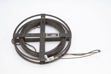
... ...Forest measurement...Forests Commission Victoria (FCV) assessment Forest measurement Surveying mapping FCV 075 Steel measuring band (1 chain - 66 feet) on metal reel FCV measuring band ...Used for measuring distances in the forest. Steel bands (out of tradition were called the chain) were created around 1890. They replaced the traditional Gunter chain. The band could be repaired by soldering slip-on joiners and than and recalibrating.Steel measuring band (1 chain - 66 feet) on metal reelFCV 075forests commission victoria (fcv), assessment, forest measurement, surveying, mapping -
 Department of Energy, Environment and Climate Action
Telescope in wooden box
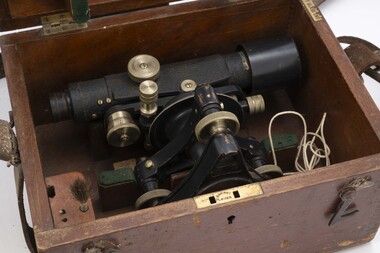
... ...Forest measurement...Department of Energy, Environment and Climate Action 71-79 Kyle Road Altona North used for surveying Forests Commission Victoria (FCV) Forest measurement Surveying Stanley Telescope used for surveying Telescope in wooden box ...used for surveyingTelescope used for surveyingStanleyforests commission victoria (fcv), forest measurement, surveying -
 Department of Energy, Environment and Climate Action
Chadwick-Miller Office Calculator
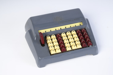
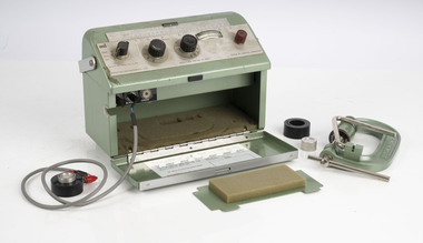
... ...Forest measurement...Forests Commission Victoria (FCV) Forest measurement Speedie add-a-matic Simple office adding machine Made from Bakelite Chadwick-Miller Inc (CMI) was a Boston based importer of low-cost gift items and stationery products sourced mostly from Japan. ...Used for adding and inventory work The Speedie was a manual adding machine that could not perform subtraction. It consisted of eight columns and five rows of keys in both maroon and ivory. It had a nine digit display that could add up. It could perform multiplication by using repeat action. If you examine the keyboard you’ll note that it only shows numbers 1 through 5. If you want to use numbers 6 through 9 then what you do is hit two keys that add up to that number. Simple office adding machine Made from Bakelite Chadwick-Miller Inc (CMI) was a Boston based importer of low-cost gift items and stationery products sourced mostly from Japan. These products were branded as Chadwick-Miller although CMI was not a manufacturer. It is known that Chadwick-Miller was in business in 1960, although its founding year is unknown. The company dissolved in 2007.Speedie add-a-maticforests commission victoria (fcv), forest measurement -
 Department of Energy, Environment and Climate Action
Hasselblad aerial camera
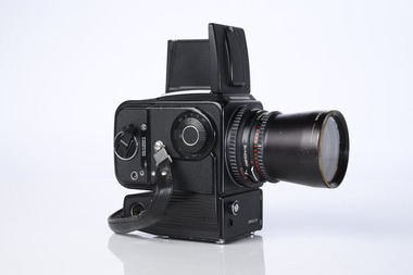
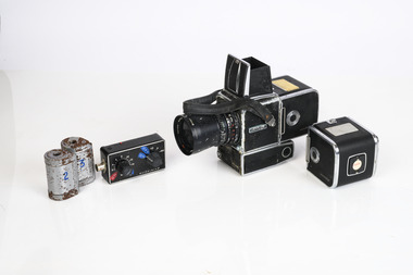
... ...Forest measurement...Forests Commission Victoria (FCV) Forest measurement Surveying mapping Hasselblad 500 ELM camera with 70mm lens, film pack, motor drive and battery In 1964 Hasselblad started production of a motorized camera, the 500 EL The EL/M is a modified version of the EL, "M" means modified, "EL" electric. ...Aerial photos were used to make maps of forest types, timber resources, to survey logging areas and regeneration, to mark boundaries of public land and new plantations, to identify new roads and tracks, as well as for fire suppression. Infrared film was sometimes used to monitor insect and disease attack. The images needed to sharp, with high contrast, and in a large format (most were printed in B&W on 9-inch by 9-inch glossy photographic paper) with at least a 60% overlap to enable stereoscopic viewing and with a 20-30% side lap to allow for aircraft drift. Preferably, the photo scale was close to the final map scale avoid to problems when enlarging and to reduce distortion. Something was needed to supplement the very expensive and infrequent large-area photography programs. From the mid-1960s Victorian foresters began experimenting with small format 70mm and 35mm cameras which proved simple, practical, cheap and flexible. It was found that any SLR camera could be used provided it had a good quality lens and fast shutter speed (preferably down to 1/1000 second). Motorised cameras with a large film capacity had obvious advantages and were essential when access to the camera was not possible during flight. It is also essential for the shutter to operate at low temperatures and those lubricated with silicones were recommended. Components of a typical FCV Divisional Office system included – A Hasselblad or Vinten 70 mm format aerial camera with a focal plane shutter which could be electrically operated. Interchangeable lenses to allow for different photo scales and flying heights. Several large film magazines, which were loaded in a darkroom, each with a capacity of 100 feet or approximately 500 frames. A remote control for the camera in single-shot mode or automatic firing at selected intervals of 2 to 50 seconds. It also needed a frame counter. A light aircraft was modified with an internal mounting for the camera to keep it level and steady. Often a hole was cut through the floor for the lens. The aircraft also needed an inbuilt 12 Volt DC battery to operate the motorised camera shutter. The front passenger seat was generally removed to improve access to the camera. An Aldis drift sight was also fitted. This might be likened to an inverted periscope and is used to determine drift, to facilitate accurate navigation along flight lines and to determine the exposure interval for stereoscopic overlap. This item is kept at Traralgon.Hasselblad 500 ELM camera with 70mm lens, film pack, motor drive and battery In 1964 Hasselblad started production of a motorized camera, the 500 EL The EL/M is a modified version of the EL, "M" means modified, "EL" electric. Perhaps the most famous use of the Hasselblad camera was during the Apollo program missions when man first landed on the Moon. Almost all of the still photographs taken during these missions used modified Hasselblad cameras. forests commission victoria (fcv), forest measurement, surveying, mapping -
 Department of Energy, Environment and Climate Action
Armstrong Rapid Log Calculator
... ...Forest measurement...forest from 1 July 1974 in cubic metres (true volume). Previously sawlogs had been sold on the basis of Hoppus volume. This simple device with two rotating wheels enabled staff in FCV offices to rapidly calculate log volumes from measurements taken in the bush of log girth and length and recorded on paper log dockets. ...An early manual device that was superseded by electronic calculators Forests Commission Victoria (FCV) Forest Harvesting Forest measurement Imperial measurement of logs (pre 1976) Office Device Twin rollers used to quickly and simply calculate true log volumes using measurements of girth and length. ...Logs were sold to sawmillers from State forest from 1 July 1974 in cubic metres (true volume). Previously sawlogs had been sold on the basis of Hoppus volume. This simple device with two rotating wheels enabled staff in FCV offices to rapidly calculate log volumes from measurements taken in the bush of log girth and length and recorded on paper log dockets. From the early 1980s automated systems became available with the advent of cheap electronic office calculators and simple computers.An early manual device that was superseded by electronic calculatorsOffice Device Twin rollers used to quickly and simply calculate true log volumes using measurements of girth and length. An allowance could also be made for pipe defects. The top roller was for larger diameter logs.Imperial measurement of logs (pre 1976)forests commission victoria (fcv), forest harvesting, forest measurement -
 Department of Energy, Environment and Climate Action
Zeiss Sketchmaster
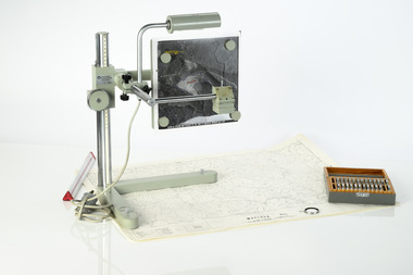
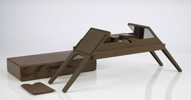
... ...Forest measurement...Forests Commission Victoria (FCV) Forest measurement mapping Surveying Zeiss Sketchmaster. c1970s. ...The Zeiss Sketchmaster was used to transfer information from aerial photographs onto scale maps. The operator views the aerial photograph and the map simultaneously and manually traces detail from the photograph onto the map. It utilises the principle of the camera lucida, patented in 1806. Various lens combinations were used on a to adjust for scale and then “rubber sheet” the image to line up topographic features like streams and roads. The photo information was then laboriously transferred using a light table onto large A0 paper maps or translucent drafting film. The maps were later hand coloured with either Derwent pencils or delicately painted with Pelikan ink wash. This item is kept at Erica.Zeiss Sketchmaster. c1970s. Includes adjustable stand, various lens in sperate box, adjustable light, map holder and magnetsforests commission victoria (fcv), forest measurement, mapping, surveying -
 Department of Energy, Environment and Climate Action
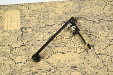
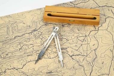
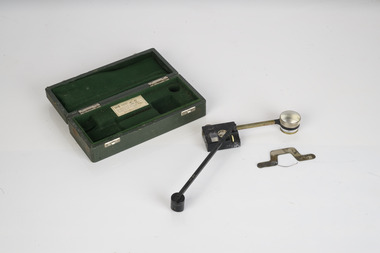
Planimeter (fixed arm)
... ...Forest measurement...Knowing the scale of the mapsheet the figure was converted to areas or hectares Generally at least three measurements were taken to ensure accuracy and precision Forests Commission Victoria (FCV) Forest measurement Surveying Benalla Planimeter used to measure areas from scale maps. ...The heavy weight is pinned onto the map and the tracing arm is used to follow the boundary to be measured Reading the number of revolutions from the two the scale wheels the area in square inches could be measured. Knowing the scale of the mapsheet the figure was converted to areas or hectares Generally at least three measurements were taken to ensure accuracy and precisionPlanimeter used to measure areas from scale maps. Includes wooden box One revolution of the main wheel equaled 10 square inches. A smaller rotating scale on the side was used to subdivide the area.Benallaforests commission victoria (fcv), forest measurement, surveying -
 Department of Energy, Environment and Climate Action
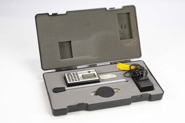
Planimeter (Digital)
... ...Forest measurement...Knowing the scale of the mapsheet the figure was converted to areas or hectares Generally at least three measurements were taken to ensure accuracy and precision Forests Commission Victoria (FCV) Forest measurement Surveying Kent Planitron UP103 Planimeter used to measure areas from scale maps. ...The heavy weight is pinned onto the map and the tracing arm is used to follow the boundary to be measured. Reading from the digital scale the area in square centimetres could be measured. Knowing the scale of the mapsheet the figure was converted to areas or hectares Generally at least three measurements were taken to ensure accuracy and precisionPlanimeter used to measure areas from scale maps. Kent Planitron UP103forests commission victoria (fcv), forest measurement, surveying -
 Department of Energy, Environment and Climate Action
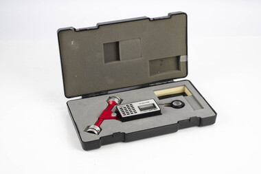
Planimeter (roller digital)
... ...Forest measurement...Knowing the scale of the mapsheet the figure was converted to areas or hectares Generally at least three measurements were taken to ensure accuracy and precision Forests Commission Victoria (FCV) Forest measurement Surveying Plancom KP90 Planimeter used to measure areas from scale maps. ...The rollers move over the map as the tracing arm is used to follow the boundary to be measured. The wheels allow unlimited horizontal travel and vertical travel within the limits of the arm movement. They measure in the X and Y directions Reading from the digital scale the area in square centimetres could be measured. Knowing the scale of the mapsheet the figure was converted to areas or hectares Generally at least three measurements were taken to ensure accuracy and precisionPlanimeter used to measure areas from scale maps. Includes box but no charger Plancom KP90forests commission victoria (fcv), forest measurement, surveying -
 Department of Energy, Environment and Climate Action
Stereoscope
... ...Forest measurement...Simple, cheap and rapid methods of obtaining photographs using 70mm and 35mm cameras were developed Forests Commission Victoria (FCV) Surveying Forest measurement Foldable metal stereoscope in wooden box with mirror covers Ex Dept of Defence Stereoscope ...This stereoscope was used to view a pair of separate and overlapping aerial photos as a single three-dimensional image. Smaller units and could be easily used in the field but this larger, mirror stereoscope was used in offices. The aerial images were used to map forest types, timber stands, new roads and tracks, firebreaks, boundaries of timber harvesting, plantations, bushfires, insect and disease attack and so on In 1928, the Forests Commission undertook its first major aerial photography project over 15,000 acres of forest which is said to be the first of its kind in Australia. During the Second World War, large areas of Victoria were photographed by the RAAF and used to produce orthophoto maps. By 1945 aerial photography of 13,000 square miles (3.4 M ha) was completed, including much of the inaccessible eastern forests. The Forests Commission started developing its own small format photography in the early 1970s. Simple, cheap and rapid methods of obtaining photographs using 70mm and 35mm cameras were developedFoldable metal stereoscope in wooden box with mirror covers Ex Dept of Defenceforests commission victoria (fcv), surveying, forest measurement -
 Department of Energy, Environment and Climate Action
Foldable Stereoscope
... ...Forest measurement...Simple, cheap and rapid methods of obtaining photographs using 70mm and 35mm cameras were developed Forests Commission Victoria (FCV) Surveying Forest measurement Benalla Foldable plastic stereoscope in box Foldable Stereoscope ...This stereoscope was used to view a pair of separate and overlapping aerial photos as a single three-dimensional image. This smaller foldable unit could be easily used in the field but larger, mirror stereoscope was used in offices. The aerial images were used to map forest types, timber stands, new roads and tracks, firebreaks, boundaries of timber harvesting, plantations, bushfires, insect and disease attack and so on In 1928, the Forests Commission undertook its first major aerial photography project over 15,000 acres of forest which is said to be the first of its kind in Australia. During the Second World War, large areas of Victoria were photographed by RAAF and used to produce orthophoto maps. By 1945 aerial photography of 13,000 square miles (3.4 M ha) was completed, including much of the inaccessible eastern forests. The Forests Commission started developing its own small format photography in the early 1970s. Simple, cheap and rapid methods of obtaining photographs using 70mm and 35mm cameras were developedFoldable plastic stereoscope in box Benallaforests commission victoria (fcv), surveying, forest measurement -
 Department of Energy, Environment and Climate Action
Area Scale - Dot Grid
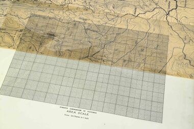
... ...Forest measurement...They were used if a planimeter wasn't available The sheet was overlayed on the map and the shape transferred with a soft China graph or erasable lead pencil The number of "dots" within the shape were counted and converted to an area Each major 1 inch square block contained 100 dots (10 x 10) Forests Commission Victoria (FCV) Forest measurement Surveying Forests Commission of Victoria Area Scale Scale 30 chains to the inch Transparent dot grid sheet Area Scale - Dot Grid ...These transparent sheets were used to measure area on maps at various scales. They were used if a planimeter wasn't available The sheet was overlayed on the map and the shape transferred with a soft China graph or erasable lead pencil The number of "dots" within the shape were counted and converted to an area Each major 1 inch square block contained 100 dots (10 x 10)Transparent dot grid sheet Forests Commission of Victoria Area Scale Scale 30 chains to the inchforests commission victoria (fcv), forest measurement, surveying -
 Department of Energy, Environment and Climate Action
Mapping dividers
... ...Forest measurement...Department of Energy, Environment and Climate Action 71-79 Kyle Road Altona North used to measure distances on maps Forests Commission Victoria (FCV) Forest measurement Surveying mapping Adjustable stainless steel mapping dividers with wooden box Mapping dividers ...used to measure distances on mapsAdjustable stainless steel mapping dividers with wooden boxforests commission victoria (fcv), forest measurement, surveying, mapping -
 Department of Energy, Environment and Climate Action
Coloured mapping inks and pens
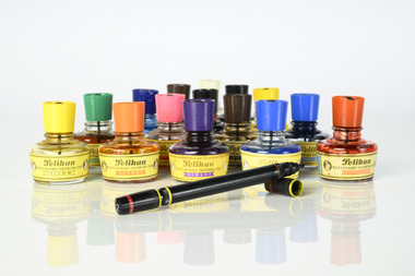
... ...Forest measurement...Forests Commission Victoria (FCV) mapping Forest measurement Surveying Pelikan Pelikan coloured inks in small glass bottles Coloured mapping inks and pens ...Coloured ink used to mark lines of paper maps. Could be used in pen or as a "wash" to colour areas with a soft sable hair paint brush Strict cartographic guidance was provided by the FCV’s 1947 publication - “Handbook of Conventional Signs and Symbols for Use in Forest Mapping and Plan Drawing”. It was slow and exacting work but very rewarding.Pelikan coloured inks in small glass bottlesPelikan forests commission victoria (fcv), mapping, forest measurement, surveying -
 Department of Energy, Environment and Climate Action
Prototype fuel moisture meter
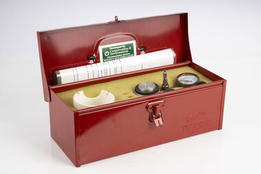
... ...Forest measurement...Forests Commission Victoria (FCV) Bushfire Forest measurement T-H Fine Fuel Meter Prototype Fuel moisture meter Prototype fuel moisture meter ...Bushfire behaviour is influenced by many things including temperature, relative humidity, forest type, fuel quantity and fuel dryness, topography and even slope. Wind has a dominant effect on the Rate of Spread (ROS), and also bushfire size, shape and direction. Fuel arrangement is as important as fuel quantity (tonnes/ha). Fibrous and ribbon bark, together with elevated and near-surface scrub fuels act as ladders which lead flames into the tree canopy. But the availability of fuel to burn depends largely on its moisture content. When it exceeds 20-25% not much will burn, whereas 12-15% is generally ideal for fuel reduction burning, but if the moisture content drops as low as 7-10% virtually everything will ignite, and fire behaviour becomes extreme. During the afternoon of the Ash Wednesday bushfires on 16 February 1983 fuel moisture contents were recorded at Stawell as low as 2.7%. Fine fuels like leaves and bark can rapidly absorb moisture after a shower of rain, or from the air when the Relative Humidity (RH) is high, and the temperature is low. Conversely, they can also dry out very quickly. So even though the overall fuel quantity in the forest doesn’t change, the fine fuel availability can increase rapidly from zero after rain to many tonnes per hectare as the fuel dries out. This can happen over a few hours on hot and windy days. Heavy fuels like logs on the ground take longer to dry out. Since the 1930s foresters, firefighters and researchers have been working to develop quick and reliable techniques for measuring fuel moisture content. One of the most accurate methods is slowly drying a sample of fuel in a conventional oven for 24-48 hours to remove all the moisture and measuring the weight difference, but this takes time and is not practical in the field when rapid measurements are needed. But oven drying is often used as a benchmark to compare other methods. Microwave ovens are faster but can cause uneven drying and even char the fuel. They are also not very practical for use in the field. Some mathematical models rely on weather records such as rainfall, wind speed, evaporation, cloud cover, shading, relative humidity, slope, aspect and season of the year to predict soil and fuel moisture. The Keetch-Byram Drought Index of soil dryness is the most common. But complex fuels with leaves, twigs, grass etc make the predictive models often inadequate for fine fuels. The most common technique in Victorian forests until recently was the trusty Speedy Moisture Meter. Originally developed in England during the 1920s for measuring moisture in wheat and other grains it was adapted for Australian forest fuels in the 1950s (I think). Fuel was first ground using a Spong mincer, often attached to the bullbar of a vehicle, and a small sample placed into the Speedy together with a measure of calcium carbide and then sealed. A chemical reaction created gas pressure which was read on the external dial. There were important techniques with cleaning, mincing and using the chemicals with the Speedy to give reliable readings, but it was quick, inexpensive, robust, portable and practical in the field. It was used routinely before igniting a fuel reduction burn or measuring fuel moisture differentials on slash burns. But in about 1996, Karen Chatto and Kevin Tolhurst from the Department’s Creswick Research Station developed the Wiltronics Fuel Moisture meter which measured electrical resistance. Wiltronics is an Australian owned company operating from Ballarat. The final result was a kit that was portable, accurate and could reliably measure fuel moisture contents between 3% and 200%. Although expensive, it is now widely used by fire agencies around the world which has virtually relegated the Speedy to the back cupboard.Prototype Fuel moisture meterT-H Fine Fuel Meterforests commission victoria (fcv), bushfire, forest measurement -
 Department of Energy, Environment and Climate Action
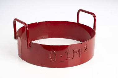
Fuel sampling ring
... ...Forest measurement...The ring was pushed into the litter to sample 0.1m2 Forests Commission Victoria (FCV) Bushfire Forest measurement Heavy metal ring with sharpened bottom edge Fuel sampling ring ...Used to sample fine fuels on the forest floor. The ring was pushed into the litter to sample 0.1m2Heavy metal ring with sharpened bottom edgeforests commission victoria (fcv), bushfire, forest measurement -
 Department of Energy, Environment and Climate Action
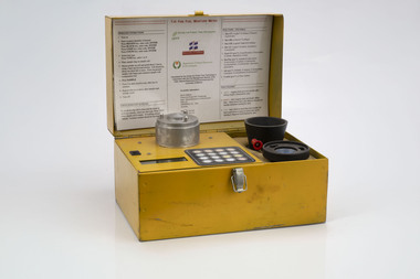
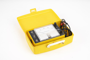
Speedy Moisture meter test kit
... ...Forest measurement...Department of Energy, Environment and Climate Action 71-79 Kyle Road Altona North Used for pressure testing and recalibrating Speedy Moisture meters Forests Commission Victoria (FCV) Bushfire Forest measurement Kit used pressure test Speedy Moisture meters Speedy Moisture meter test kit ...Used for pressure testing and recalibrating Speedy Moisture metersKit used pressure test Speedy Moisture metersforests commission victoria (fcv), bushfire, forest measurement -
 Department of Energy, Environment and Climate Action
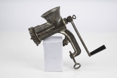
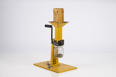
Spong Fuel Mincer
... ...Forest measurement...Forests Commission Victoria (FCV) Bushfire Forest measurement Spong No 10 food mincer Spong Fuel Mincer ...Used to prepare fuel samples to measure their moisture content. Representative samples of fine fuel such as bark, leaves, twigs etc were minced first through a course mincing plate, then a fine plate and the moisture content measured with a Speedy moisture meter or other device. The availability of fuel to burn depends largely on its moisture content. When it exceeds 20-25% not much will burn, whereas 12-15% is generally ideal for fuel reduction burning, but if the moisture content drops as low as 7-10% virtually everything will ignite, and fire behaviour becomes extreme. During the afternoon of the Ash Wednesday bushfires on 16 February 1983 fuel moisture contents were recorded at Stawell as low as 2.7%. Fine fuels like leaves and bark can rapidly absorb moisture after a shower of rain, or from the air when the Relative Humidity (RH) is high, and the temperature is low. Conversely, they can also dry out very quickly. So even though the overall fuel quantity in the forest doesn’t change, the fine fuel availability can increase rapidly from zero after rain to many tonnes per hectare as the fuel dries out. This can happen over a few hours on hot and windy days. Heavy fuels like logs on the ground take longer to dry out. Spong No 10 food mincerforests commission victoria (fcv), bushfire, forest measurement -
 Department of Energy, Environment and Climate Action
Fuel Mincer
... ...Forest measurement...Forests Commission Victoria (FCV) Bushfire Forest measurement Fuel mincer Made at Altona as an alternative design to the commercial Spong Mincer With wooden plug to push fuel into the mincer and glass jar to collect sample Fuel Mincer ...Used to mince fuel samples to measure moisture content Representative samples of fuel such as bark, leaves, twigs etc were minced and the moisture measured The availability of fuel to burn depends largely on its moisture content. When it exceeds 20-25% not much will burn, whereas 12-15% is generally ideal for fuel reduction burning, but if the moisture content drops as low as 7-10% virtually everything will ignite, and fire behaviour becomes extreme. During the afternoon of the Ash Wednesday bushfires on 16 February 1983 fuel moisture contents were recorded at Stawell as low as 2.7%. Fine fuels like leaves and bark can rapidly absorb moisture after a shower of rain, or from the air when the Relative Humidity (RH) is high, and the temperature is low. Conversely, they can also dry out very quickly. So even though the overall fuel quantity in the forest doesn’t change, the fine fuel availability can increase rapidly from zero after rain to many tonnes per hectare as the fuel dries out. This can happen over a few hours on hot and windy days. Heavy fuels like logs on the ground take longer to dry out. Fuel mincer Made at Altona as an alternative design to the commercial Spong Mincer With wooden plug to push fuel into the mincer and glass jar to collect sampleforests commission victoria (fcv), bushfire, forest measurement -
 Department of Energy, Environment and Climate Action
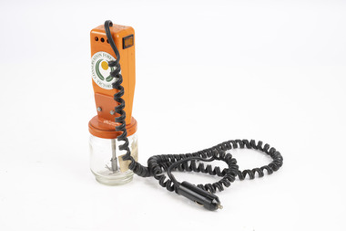
Electric Fuel Mincer
... ...Forest measurement...Forests Commission Victoria (FCV) Bushfire Forest measurement Battery operated Fuel mincer. Plugs into 12 volt car cigarette lighter socket Adaption using parts from commercial food processor Made at Altona as an alternative design to the commercial Spong Mincer Glass jar to collect sample Electric Fuel Mincer ...Used to mince fuel samples to measure moisture content Representative samples of fuel such as bark, leaves, twigs etc were minced and the moisture measured The availability of fuel to burn depends largely on its moisture content. When it exceeds 20-25% not much will burn, whereas 12-15% is generally ideal for fuel reduction burning, but if the moisture content drops as low as 7-10% virtually everything will ignite, and fire behaviour becomes extreme. During the afternoon of the Ash Wednesday bushfires on 16 February 1983 fuel moisture contents were recorded at Stawell as low as 2.7%. Fine fuels like leaves and bark can rapidly absorb moisture after a shower of rain, or from the air when the Relative Humidity (RH) is high, and the temperature is low. Conversely, they can also dry out very quickly. So even though the overall fuel quantity in the forest doesn’t change, the fine fuel availability can increase rapidly from zero after rain to many tonnes per hectare as the fuel dries out. This can happen over a few hours on hot and windy days. Heavy fuels like logs on the ground take longer to dry out. Battery operated Fuel mincer. Plugs into 12 volt car cigarette lighter socket Adaption using parts from commercial food processor Made at Altona as an alternative design to the commercial Spong Mincer Glass jar to collect sampleforests commission victoria (fcv), bushfire, forest measurement -
 Department of Energy, Environment and Climate Action
Timber moisture meter adapted for forest fuels
... ...Forest measurement...Forests Commission Victoria (FCV) Bushfire Forest measurement Adaption of a timber moisture meter made by the FCV radio lab to measure fuel Timber moisture meter adapted for forest fuels ...Representative samples of fuel such as bark, leaves, twigs etc were minced and the moisture measured The availability of fuel to burn depends largely on its moisture content. When it exceeds 20-25% not much will burn, whereas 12-15% is generally ideal for fuel reduction burning, but if the moisture content drops as low as 7-10% virtually everything will ignite, and fire behaviour becomes extreme. During the afternoon of the Ash Wednesday bushfires on 16 February 1983 fuel moisture contents were recorded at Stawell as low as 2.7%. Fine fuels like leaves and bark can rapidly absorb moisture after a shower of rain, or from the air when the Relative Humidity (RH) is high, and the temperature is low. Conversely, they can also dry out very quickly. So even though the overall fuel quantity in the forest doesn’t change, the fine fuel availability can increase rapidly from zero after rain to many tonnes per hectare as the fuel dries out. This can happen over a few hours on hot and windy days. Heavy fuels like logs on the ground take longer to dry out. Adaption of a timber moisture meter made by the FCV radio lab to measure fuelforests commission victoria (fcv), bushfire, forest measurement -
 Department of Energy, Environment and Climate Action
Marconi Moisture meter
... ...Forest measurement...Forests Commission Victoria (FCV) Bushfire Forest measurement TF 933 C Adaption of a commercial timber moisture meter measure fuel Marconi Moisture meter ...Used to measure fuel moisture content Representative samples of fuel such as bark, leaves, twigs etc were minced and the moisture measured The availability of fuel to burn depends largely on its moisture content. When it exceeds 20-25% not much will burn, whereas 12-15% is generally ideal for fuel reduction burning, but if the moisture content drops as low as 7-10% virtually everything will ignite, and fire behaviour becomes extreme. During the afternoon of the Ash Wednesday bushfires on 16 February 1983 fuel moisture contents were recorded at Stawell as low as 2.7%. Fine fuels like leaves and bark can rapidly absorb moisture after a shower of rain, or from the air when the Relative Humidity (RH) is high, and the temperature is low. Conversely, they can also dry out very quickly. So even though the overall fuel quantity in the forest doesn’t change, the fine fuel availability can increase rapidly from zero after rain to many tonnes per hectare as the fuel dries out. This can happen over a few hours on hot and windy days. Heavy fuels like logs on the ground take longer to dry out. Adaption of a commercial timber moisture meter measure fuelTF 933 Cforests commission victoria (fcv), bushfire, forest measurement -
 Department of Energy, Environment and Climate Action
Delton Moisture meter
... ...Forest measurement...Forests Commission Victoria (FCV) Bushfire Forest measurement DCR9-T Commercial timber moisture meter used to measure fuel Delton Moisture meter ...Used to measure moisture content by electric current resistance Representative samples of fuel such as bark, leaves, twigs etc were minced and the moisture measured The availability of fuel to burn depends largely on its moisture content. When it exceeds 20-25% not much will burn, whereas 12-15% is generally ideal for fuel reduction burning, but if the moisture content drops as low as 7-10% virtually everything will ignite, and fire behaviour becomes extreme. During the afternoon of the Ash Wednesday bushfires on 16 February 1983 fuel moisture contents were recorded at Stawell as low as 2.7%. Fine fuels like leaves and bark can rapidly absorb moisture after a shower of rain, or from the air when the Relative Humidity (RH) is high, and the temperature is low. Conversely, they can also dry out very quickly. So even though the overall fuel quantity in the forest doesn’t change, the fine fuel availability can increase rapidly from zero after rain to many tonnes per hectare as the fuel dries out. This can happen over a few hours on hot and windy days. Heavy fuels like logs on the ground take longer to dry out. Commercial timber moisture meter used to measure fuelDCR9-Tforests commission victoria (fcv), bushfire, forest measurement -
 Department of Energy, Environment and Climate Action
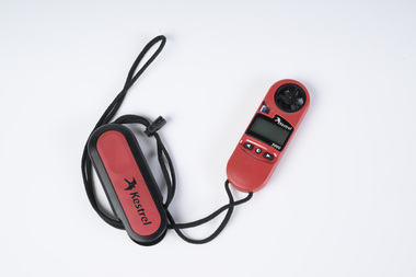
Anemometer
... ...Forest measurement...Department of Energy, Environment and Climate Action 71-79 Kyle Road Altona North Used to measure wind speed which is an important factor in fire behaviour Forests Commission Victoria (FCV) Bushfire Forest measurement Kestrel 3000 Hand-held battery-operated anemometer used to measure wind speed Anemometer ...Used to measure wind speed which is an important factor in fire behaviourHand-held battery-operated anemometer used to measure wind speedKestrel 3000forests commission victoria (fcv), bushfire, forest measurement -
 Department of Energy, Environment and Climate Action
Equipment - Criterion Survey Laser
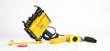
... ...Forest measurement...forests since the late 1920s, coinciding with arrival of the three Norwegian foresters. The program was accelerated during the post-war housing boom. It was driven by the push eastwards away from the Central Highlands to find timber resources after the 1939 bushfire salvage was completed. Spending time in the field with assessment branch was a “rite of passage” for many young forestry graduates leaving Creswick. The work was arduous, and measurements...This item was donated to the Beechworth museum by Peter Black in 2015 and is now at Altona and recorded in Victorian Collections Surveying Forest measurement Laser Technology Inc, Englewood, Colorado, USA Criterion Survey Laser with box and battery Equipment Criterion Survey Laser ...There had been timber assessments in Victorian State forests since the late 1920s, coinciding with arrival of the three Norwegian foresters. The program was accelerated during the post-war housing boom. It was driven by the push eastwards away from the Central Highlands to find timber resources after the 1939 bushfire salvage was completed. Spending time in the field with assessment branch was a “rite of passage” for many young forestry graduates leaving Creswick. The work was arduous, and measurements were taken with simple and robust equipment like Gunters chains, prismatic compass, Abney levels, barometers and clinometers. Data was recorded by hand onto waterproof paper. The Statewide Forest Resource Inventory (SFRI) project began in 1993 and followed a few years after the release Timber industry Strategy. The aim was to bolster the existing 1:25000 scale mapping and improve the accuracy of the volume and growth estimates for the forest estate. This scary looking gadget looks like a speed radar used by the cops. The LTI Criterion Survey Laser and Rangefinder was a powerful instrument that could measure and record tree height, diameter at any visible point up the tree and branch take-off points. It was used to identify and map tree faults such as branches, scars and knots and to calculate tree taper functions. When used correctly, it has an accuracy of better than 1% for height and diameter. It could also measure survey information such as asmuth, distance and elevation. It was expensive back in the day (more than $20,000) - this one was manufactured in 1996 - and heavy. This item was donated to the Beechworth museum by Peter Black in 2015 and is now at Altona and recorded in Victorian Collections Criterion Survey Laser with box and batteryLaser Technology Inc, Englewood, Colorado, USAsurveying, forest measurement -
 Department of Energy, Environment and Climate Action
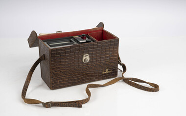
Hasselblad aerial camera with carry case, spare batteries, and film cases (overall poor condtion)
... ...Forest measurement...This item was found in storage at the Beechworth museum and its in poor condtion Forests Commission Victoria (FCV) Forest measurement Surveying mapping Hasselblad 500 ELM camera with 70mm lens, film pack, motor drive and battery In 1964 Hasselblad started production of a motorized camera, the 500 EL The EL/M is a modified version of the EL, "M" means modified, "EL" electric. ...Aerial photos were used to make maps of forest types, timber resources, to survey logging areas and regeneration, to mark boundaries of public land and new plantations, to identify new roads and tracks, as well as for fire suppression. Infrared film was sometimes used to monitor insect and disease attack. The images needed to sharp, with high contrast, and in a large format (most were printed in B&W on 9-inch by 9-inch glossy photographic paper) with at least a 60% overlap to enable stereoscopic viewing and with a 20-30% side lap to allow for aircraft drift. Preferably, the photo scale was close to the final map scale avoid to problems when enlarging and to reduce distortion. Something was needed to supplement the very expensive and infrequent large-area photography programs. From the mid-1960s Victorian foresters began experimenting with small format 70mm and 35mm cameras which proved simple, practical, cheap and flexible. It was found that any SLR camera could be used provided it had a good quality lens and fast shutter speed (preferably down to 1/1000 second). Motorised cameras with a large film capacity had obvious advantages and were essential when access to the camera was not possible during flight. It is also essential for the shutter to operate at low temperatures and those lubricated with silicones were recommended. Components of a typical FCV Divisional Office system included – A Hasselblad or Vinten 70 mm format aerial camera with a focal plane shutter which could be electrically operated. Interchangeable lenses to allow for different photo scales and flying heights. Several large film magazines, which were loaded in a darkroom, each with a capacity of 100 feet or approximately 500 frames. A remote control for the camera in single-shot mode or automatic firing at selected intervals of 2 to 50 seconds. It also needed a frame counter. A light aircraft was modified with an internal mounting for the camera to keep it level and steady. Often a hole was cut through the floor for the lens. The aircraft also needed an inbuilt 12 Volt DC battery to operate the motorised camera shutter. The front passenger seat was generally removed to improve access to the camera. An Aldis drift sight was also fitted. This might be likened to an inverted periscope and is used to determine drift, to facilitate accurate navigation along flight lines and to determine the exposure interval for stereoscopic overlap. This item was found in storage at the Beechworth museum and its in poor condtionHasselblad 500 ELM camera with 70mm lens, film pack, motor drive and battery In 1964 Hasselblad started production of a motorized camera, the 500 EL The EL/M is a modified version of the EL, "M" means modified, "EL" electric. Perhaps the most famous use of the Hasselblad camera was during the Apollo program missions when man first landed on the Moon. Almost all of the still photographs taken during these missions used modified Hasselblad cameras. forests commission victoria (fcv), forest measurement, surveying, mapping -
 Department of Energy, Environment and Climate Action
Planimeter (fixed arm)
... ...Forest measurement...Knowing the scale of the mapsheet the figure was converted to areas or hectares Generally at least three measurements were taken to ensure accuracy and precision Forests Commission Victoria (FCV) Forest measurement Surveying Benalla Planimeter used to measure areas from scale maps. ...The heavy weight is pinned onto the map and the tracing arm is used to follow the boundary to be measured Reading the number of revolutions from the two the scale wheels the area in square inches could be measured. Knowing the scale of the mapsheet the figure was converted to areas or hectares Generally at least three measurements were taken to ensure accuracy and precisionPlanimeter used to measure areas from scale maps. Includes wooden box One revolution of the main wheel equaled 10 square inches. A smaller rotating scale on the side was used to subdivide the area.Benallaforests commission victoria (fcv), forest measurement, surveying -
 Department of Energy, Environment and Climate Action
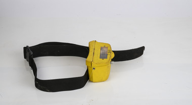
HipChain Distance Measurer
... Forest measurement...Once you reach your endpoint, break the thread and continue. Forest measurement Surveying HipChain Distance Measurer HipChain Distance Measurer ...Hipchains are a reliable tool for precise long distance measurement, particularly with irregular boundaries, in rough terrain or thick scrub To use, simply tie the cotton thread to a fixed object at your starting point, zero the counter, and start walking. As you move, the thread extends, turning the counter. The instrument attaches to your belt, keeping the thread taut and accurate. Once you reach your endpoint, break the thread and continue.HipChain Distance Measurerforest measurement, surveying