Showing 171 items matching "forest track"
-
 Otway Districts Historical Society
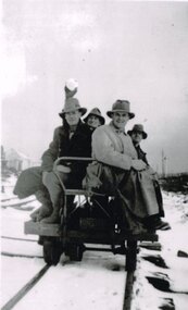
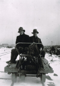
Photograph, R. Preston, Beech Forest: Track gang in snow, c.1940, c.1940
... Beech Forest: Track gang in snow, c.1940....beech forest; railways; g. newland; ned hewing; bill taylor; jim gowty; snow; track gang;...There were two track gangs at Beech Forest until 1954, so a large number of gangers and repairers was present over the years. ...In snow at Beech Forest, a track gang on a trolley at the entrance to the Way and Works shed, comprising G. ...Newland, Ned Hewing, Bill Taylor, Jim Gowty, and Buck. Beech Forest: Track gang in snow, c.1940. Photograph R. ...The railway track was maintained initially by seven three-man gangs headed by a ganger. The gangers tended to be promoted into the Otways but many of their subordinate staff of repairers were local recruits. There were two track gangs at Beech Forest until 1954, so a large number of gangers and repairers was present over the years. World War 2 with petrol and rubber rationing provided a boost to the line. The 1939 bushfire killed a great deal of timber which had to transported out of the Otways, and the commencement of a vigorous wartime pulp wood traffic from Beech Forest meant that only the railway could efficiently handle the volume of traffic. By early 1940 not only the Garratt was running a daily train to Beech Forest but an NA goods train was scheduled to run at night. As a result the track gangs were also particularly busy at the same time.B/W. In snow at Beech Forest, a track gang on a trolley at the entrance to the Way and Works shed, comprising G. Newland, Ned Hewing, Bill Taylor, Jim Gowty, and Buck.beech forest; railways; g. newland; ned hewing; bill taylor; jim gowty; snow; track gang; -
 Eltham District Historical Society Inc
Photograph, Goodwood Powelltown Melbourne Daily rear view
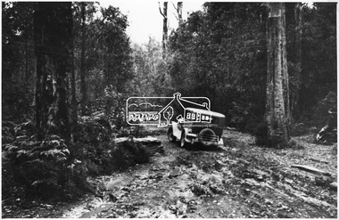
... ...forest track...Two vehicles, possibly 1929 Chryslers negotiate a forest track, probably in the Kinglake National Park. ...Eltham District Historical Society Inc 728 Main Rd Eltham melbourne Two vehicles, possibly 1929 Chryslers negotiate a forest track, probably in the Kinglake National Park. ...Two vehicles, possibly 1929 Chryslers negotiate a forest track, probably in the Kinglake National Park. Front vehicle has sign: Goodwood Powelltown Melbourne daily". Source: Forests Commission of Victoria. Ref. JJ 397This photo forms part of a collection of photographs gathered by the Shire of Eltham for their centenary project book,"Pioneers and Painters: 100 years of the Shire of Eltham" by Alan Marshall (1971). The collection of over 500 images is held in partnership between Eltham District Historical Society and Yarra Plenty Regional Library (Eltham Library) and is now formally known as the 'The Shire of Eltham Pioneers Photograph Collection.' It is significant in being the first community sourced collection representing the places and people of the Shire's first one hundred years.Digital imagesepp, shire of eltham pioneers photograph collection, kinglake, goodwood powelltown melbourne daily, automobile, forest track, chrysler, kinglake national park -
 Eltham District Historical Society Inc
Photograph, Goodwood Powelltown Melbourne Daily
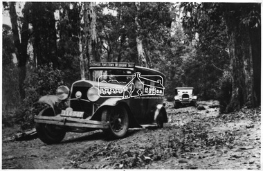
... ...Forest track...Two cars, probably 1929 Chryslers navigate the forest track probably Kinglake National Park. ...Eltham District Historical Society Inc 728 Main Rd Eltham melbourne Two cars, probably 1929 Chryslers navigate the forest track probably Kinglake National Park. Front vehicle has sign: "Goodwood Powelltown Melbourne daily". ...Two cars, probably 1929 Chryslers navigate the forest track probably Kinglake National Park. Front vehicle has sign: "Goodwood Powelltown Melbourne daily". Photo sourced from the Forests Commission of Victoria. Ref. JJ 399This photo forms part of a collection of photographs gathered by the Shire of Eltham for their centenary project book,"Pioneers and Painters: 100 years of the Shire of Eltham" by Alan Marshall (1971). The collection of over 500 images is held in partnership between Eltham District Historical Society and Yarra Plenty Regional Library (Eltham Library) and is now formally known as the 'The Shire of Eltham Pioneers Photograph Collection.' It is significant in being the first community sourced collection representing the places and people of the Shire's first one hundred years.Digital imagesepp, shire of eltham pioneers photograph collection, kinglake, goodwood powelltown melbourne daily, automobile, chrysler, kinglake national park, forest track -
 Lakes Entrance Historical Society
Photograph - Log Cabin at Harrisons Track, Colquhoun forest 1999
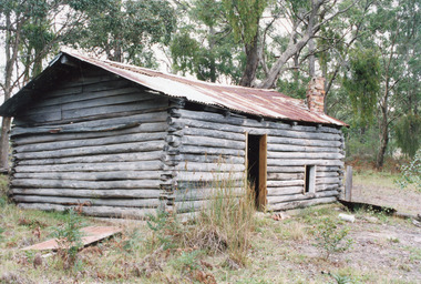
... Log Cabin at Harrisons Track, Colquhoun forest 1999...Lakes Entrance Victoria Photograph Log Cabin at Harrisons Track, Colquhoun forest 1999 ...As story goes - An Italian migrant ? Ianuzzi built the cabin as a home for himself and prospective bride, she declined the offer, he made a living growing vegetables, which he sold, but a generous man who gave away just as much.Colour photograph of a log cabin bush hut situated at Harrisons Track, Colquhoun, showing rustic dwelling, rusting corrugated iron roof without guttering, small door and window on side, top of brick chimney through roof. Lakes Entrance Victoriacabin, buildings -
 Lakes Entrance Historical Society
Map - Bogong Fire Complex Topographic Map Base Swifts Creek Sheet 8, GIS Unit Dept Primary Industry, 2003/1
... Map shows fire complex of East Gippsland names, towns, rivers and forest tracks...Lakes Entrance Historical Society 4 Marine Parade Lakes Entrance gippsland Grid represents 1,000 metre intervals of the Australian Map Grid (AMG) Australian Geoletic Datum Topography Fires Waterways Forest Roads and Streets Map shows fire complex of East Gippsland names, towns, rivers and forest tracks Map Bogong Fire Complex Topographic Map Base Swifts Creek Sheet 8 GIS Unit Dept Primary Industry ...Grid represents 1,000 metre intervals of the Australian Map Grid (AMG) Australian Geoletic DatumMap shows fire complex of East Gippsland names, towns, rivers and forest trackstopography, fires, waterways, forest, roads and streets -
 The Beechworth Burke Museum
Photograph, Christmas 1941
... ...forest track...Taken on Christmas of 1941, shown is a track to Lake Kerferd with forest on both sides. The construction on Lake Kerferd began in 1862 however it wasn't completed until 1874 due to engineering and funding issues. ...It is also linked to political identity of George Briscoe Kerferd and the Beechworth Municipal Council. lake kerferd beechworth water scheme water reserve forest track forest pathway reservoir Legislative Assembly Hon. ...Taken on Christmas of 1941, shown is a track to Lake Kerferd with forest on both sides. The construction on Lake Kerferd began in 1862 however it wasn't completed until 1874 due to engineering and funding issues. The lake was named after George Briscoe Kerferd (1831–1889) who was responsible for Beechworth's water scheme. George Briscoe Kerferd was born on 21 January 1831 in Liverpool, England and arrived in Melbourne April 1853. He spent his first years in Australia in Bendigo before settling down in Beechworth as a wine and spirits merchant. He married Ann Martindale on 17th December 1853 at St James Cathedral, Melbourne and between them they had three sons and five daughters. Kerferd began his political and legal career in Beechworth when he was first elected to the Municipal Council in May 1857. Later he would be elected to the Legislative Assembly for the Ovens District in November 1864, and continued to represent the area until February 1886.This photograph is historically significant as it provides insight into surrounding areas of the water reserves of Victoria. It is also linked to political identity of George Briscoe Kerferd and the Beechworth Municipal Council.Black and white rectangular photograph printed on matte photographic paper.Obverse: Reverse: 8163/ Back track to Lake Kerford/ Beechworth/ Xmas 1941lake kerferd, beechworth, water scheme, water reserve, forest track, forest pathway, reservoir, legislative assembly, hon. george briscoe kerferd, catchments, beechworth water reserve, beechworth catchments, municipal council, st. james cathedral, lakes, reserve, water supply, political projects -
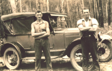 Lakes Entrance Historical Society
Photograph - T Model Ford, Charles Pettman and William Henry Flukes, 1936 c
... Black and white photograph of Charles Pettman and William Henry Flukes standing beside Charles T Model Ford on a forest track East Gippsland...Lakes Entrance Historical Society 4 Marine Parade Lakes Entrance gippsland The T Model Ford cost him 28 pounds Vehicles Topography Black and white photograph of Charles Pettman and William Henry Flukes standing beside Charles T Model Ford on a forest track East Gippsland Charles Pettman and William Henry Flukes Photograph T Model Ford ...The T Model Ford cost him 28 poundsBlack and white photograph of Charles Pettman and William Henry Flukes standing beside Charles T Model Ford on a forest track East Gippslandvehicles, topography -
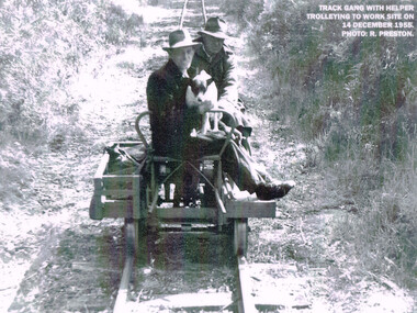 Otway Districts Historical Society
Photograph, R. Preston, Trolleying to work site, 1955, 14 December 1955
... Beech Forest; railways; track gang;...The track was maintained by seven three-man gangs based at Colac, Barongarook, Gellibrand, Banool, Beech Forest (2), and Lavers Hill. ...After 1954, the sole surviving track gang, in charge of Paddy Balcombe, stayed until the line closed. Beech Forest; railways; track gang; A railway track gang, with helper, trolleying to a work site, on 14 December, 1955. ...At its peak the Beech Forest railway employed more than 21 staff between Colac and Crowes. Gangers (men in charge of the track gangs) tended to be promoted into the Otways but many of their subordinate repairers were local recruits. A few of the men who worked in the original construction gangs of 1900-1902 remained and obtained positions in the track gangs along the line. The track was maintained by seven three-man gangs based at Colac, Barongarook, Gellibrand, Banool, Beech Forest (2), and Lavers Hill. However, track gangs lessened as the line shortened. After 1954, the sole surviving track gang, in charge of Paddy Balcombe, stayed until the line closed.A railway track gang, with helper, trolleying to a work site, on 14 December, 1955.beech forest; railways; track gang; -
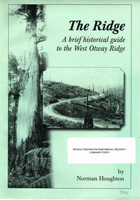 Otway Districts Historical Society
Book, The Ridge. Norman Houghton, 2008
... otway ranges; norman houghton; crowes; lavers hill; macknott; stalker; pettit's siding; wyelangta; the tanks; kincaid; pile siding; weeaproinah; ferguson; buchanan; beech forest; olangolah; turtons track....Otway Districts Historical Society Cliff Young Drive Beech Forest great-ocean-road otway ranges; norman houghton; crowes; lavers hill; macknott; stalker; pettit's siding; wyelangta; the tanks; kincaid; pile siding; weeaproinah; ferguson; buchanan; beech forest; olangolah; turtons track. The Ridge. A brief historical guide to the West Otway Ridge. ...The Ridge. A brief historical guide to the West Otway Ridge. Norman Houghton. Soft cover. iv, 16 p.; illus, map. Artwork and layout: Desktop Dynamics.otway ranges; norman houghton; crowes; lavers hill; macknott; stalker; pettit's siding; wyelangta; the tanks; kincaid; pile siding; weeaproinah; ferguson; buchanan; beech forest; olangolah; turtons track. -
 Otway Districts Historical Society
Photograph, Woosnan, Frank, Track gang at Beech Forest, c.1940, c.1940
... Track gang at Beech Forest, c.1940...colac; beech forest; crowes; railway; track gangs;...The track was maintained by seven three-man gangs based at Colac, Barongarook, Gellibrand, Banool, Beech Forest (where the second Beech Forest crew was based at Wyelangta), and Lavers Hill....Track gang on an NK wagon at Beech Forest, c.1940. Snow covers the ground. ...The track was maintained by seven three-man gangs based at Colac, Barongarook, Gellibrand, Banool, Beech Forest (where the second Beech Forest crew was based at Wyelangta), and Lavers Hill. colac; beech forest; crowes; railway; track gangs; Track gang on an NK wagon at Beech Forest, c.1940. ...At its peak the Colac-Beech Forest-Crowes railway employed more than 21 staff tending the lines that the trains ran over. Gangers (the men in charge of the track gangs) tended to be promoted into the Otways but many of their subordinate repairers were local recruits. A few of the men who worked on the original construction gangs of 1900-02 remained and obtained positions in the track gangs along the line, but these eased out over time. The track was maintained by seven three-man gangs based at Colac, Barongarook, Gellibrand, Banool, Beech Forest (where the second Beech Forest crew was based at Wyelangta), and Lavers Hill.Track gang on an NK wagon at Beech Forest, c.1940. Snow covers the ground. B/W.colac; beech forest; crowes; railway; track gangs; -
 Marysville & District Historical Society
Book - Paperback book, Ghost Towns of the Mountain Goldfields, 1999
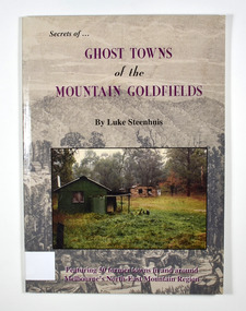
... Cover has a drawing depicting horses, both ridden and pack, walking along a forest track on their way to a small town. There are heavily forested mountains in the distance. ...Cover has a drawing depicting horses, both ridden and pack, walking along a forest track on their way to a small town. There are heavily forested mountains in the distance. ...Ghost towns of the mountain goldfields in VictoriaPaperback. Cover has a drawing depicting horses, both ridden and pack, walking along a forest track on their way to a small town. There are heavily forested mountains in the distance. Overlaid onto the drawing is a modern photograph of an old stone building. In the foreground is a green timber building with a water tank and verandah. It is all set in the clearing in the middle of a forest.Stamp of the Marysville & District Historical Society Inc / P.O. Box 22 / Marysville 3779 Also the inscription: To Alma / Thanks for your help / Signature / LS / November 1999gold, gold mining, gold town, ghost town, victoria, australia, history -
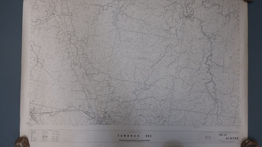
Lakes Entrance Historical Society
Map - Tambo Shire Map
... Shows Nowa Nowa forest area, roads and tracks...Roads and Streets Shows Nowa Nowa forest area, roads and tracks Map Tambo Shire Map ...Shows Nowa Nowa forest area, roads and tracksroads and streets -
 Otway Districts Historical Society
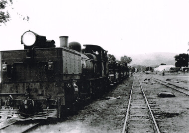
Photograph, Les Ogden, Gellibrand: Excursion train to Beech Forest, 1960, 1960
... Locomotive G42 and an excursion train to Beech Forest, on track number one, in 1960. The fireman, Les Ogden, hangs from the engine. ...Locomotive G42 and an excursion train to Beech Forest, on track number one, in 1960. The fireman, Les Ogden, hangs from the engine. ...Another excursion train travels to Beech Forest in 1960. At Gellibrand railway yards engine G42 leads the train with driver L. Moore and fireman, Les Ogden.B/W. Locomotive G42 and an excursion train to Beech Forest, on track number one, in 1960. The fireman, Les Ogden, hangs from the engine. The other tracks are empty.gellibrand; railway; loco g42; -
 Bendigo Historical Society Inc.
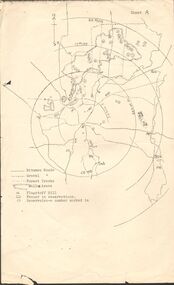
Map - PETER ELLIS COLLECTION: MAP OF WHIPSTICK
... Bitumen roads, gravel, forest tracks, Mallee Areas, Flagstaff Hill, fenced in reservations and reservoirs are marked. ...Bitumen roads, gravel, forest tracks, Mallee Areas, Flagstaff Hill, fenced in reservations and reservoirs are marked. ...Two maps of the Whipstick - Sheet A and Sheet B. Sheet A shows the Whipstick in relation to Bendigo and some surrounding places. Bitumen roads, gravel, forest tracks, Mallee Areas, Flagstaff Hill, fenced in reservations and reservoirs are marked. Also, a circle and part circles of 5-, 10-, 15- and 20-mile radius is marked. North & South are marked. Sheet B is an enlarged area of the Whipstick Scrub area. North and South is marked. There are a number of letters written over both maps.map, bendigo, peter ellis collection, the whipstick, flagstaff hill -
Bendigo Historical Society Inc.
Map - CAMPBELL COLLECTION: BENDIGO AND DISTRICT MAPS
... Bendigo Whipstick Forest Park, 1:75,000, reserved forest and crown land, highway main road access forest tracks. New Moon Mine, Elliot Dam, Nuggety Dam, Rogers Tree, Old Tom Mine, Blow Holes, Skylark Dam, Monument Rock, Hartland Eucalyptus Still and Dam, Hartland Eucalyptus Farm, Millwood Dam, Sandner Eucalyptus Still Site, Various unmarked dams. ...Bendigo Whipstick Forest Park, 1:75,000, reserved forest and crown land, highway main road access forest tracks. New Moon Mine, Elliot Dam, Nuggety Dam, Rogers Tree, Old Tom Mine, Blow Holes, Skylark Dam, Monument Rock, Hartland Eucalyptus Still and Dam, Hartland Eucalyptus Farm, Millwood Dam, Sandner Eucalyptus Still Site, Various unmarked dams. ...Map. Bendigo Whipstick Forest Park, 1:75,000, reserved forest and crown land, highway main road access forest tracks. New Moon Mine, Elliot Dam, Nuggety Dam, Rogers Tree, Old Tom Mine, Blow Holes, Skylark Dam, Monument Rock, Hartland Eucalyptus Still and Dam, Hartland Eucalyptus Farm, Millwood Dam, Sandner Eucalyptus Still Site, Various unmarked dams. (number 391 in map cupboard 1)map, bendigo, country lands -
Lakes Entrance Historical Society
Map - Bairnsdale Region/Nowa Nowa Operations Area, Dept of Conservation and Natural Resources, February 1980
... Shows forest area, roads, tracks, operational boundery, private property, fire tower, helipad, Renic area hut....Lakes Entrance Historical Society 4 Marine Parade Lakes Entrance gippsland Forest Roads and Streets private property fire tower helipad huts Shows forest area, roads, tracks, operational boundery, private property, fire tower, helipad, Renic area hut. ...Shows forest area, roads, tracks, operational boundery, private property, fire tower, helipad, Renic area hut.forest, roads and streets, private property, fire tower, helipad, huts -
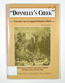 Marysville & District Historical Society
Book - Paperback book, Donnelly's Creek-From rush to ruin of a Gippsland Mountain Goldfield, 1990
... They are walking along a forest track that has some tree stumps alongside it.The back cover has two colour photographs. ...They are walking along a forest track that has some tree stumps alongside it.The back cover has two colour photographs. ...A history of the Donnelly's Creek gold mine in VictoriaPaperback. Front cover has a drawing depicting two horses carrying packs followed by a man mounted on a horse. There is also two men on foot following with packs and walking poles. They are walking along a forest track that has some tree stumps alongside it.The back cover has two colour photographs. The top one is of an old wooden building with what appears to be an attached lean to. Both of the buildings have stone chimneys. There is a group of people sitting and standing outside the main building. The bottom photograph appears to be the ruins of a building and a fence. There are three people viewing the ruins.The captions accompanying the photographs are: History revisited - O'Sullivans Old Toombon Hotel Recreated and Remnants of a Bygone Mining Era.Stamp of the Marysville & District Historical Society Inc / P O Box 22 / Marysville 3779gold, gold miner, gold mining, gold field, gippsland, victoria, australia, history, fulton's creek, seaton, walhalla, aberfeldy, jericho, wood's point -
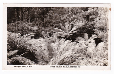 Marysville & District Historical Society
Postcard (item) - Black and white postcard, Rose Stereograph Company, By the Wolfram Track, Marysville, Vic, 1913-1967
... A black and white photograph of a part of the forest that the Wolfram Track, which is part of the Wilks Creek Walking Track, runs through. ...A black and white photograph of a part of the forest that the Wolfram Track, which is part of the Wilks Creek Walking Track, runs through. ...A postcard in a series produced by the Rose Stereograph Company in Victoria, Australia as a souvenir of Marysville.A black and white photograph of a part of the forest that the Wolfram Track, which is part of the Wilks Creek Walking Track, runs through. The Wilks Creek Walking Track is in Marysville in Victoria. The Wolfram Track is named after the Wilks Creek Wolfram Mine which opened in around 1894. Wolframite is one of the principle ores of tungsten. The discovery was made in Wolfram Creek by a Mr Robinson who was probably a local of the district. Four creeks eventually proved to carry alluvial deposits of the ore; Wolfram Creek, Opas Creek, Quartz Creek and Main Creek. These creeks run south-east into Deep Creek, a tributary of the O'Shannassy River which, in turn, runs into the Yarra River.POST CARD The "Rose" Series/ De Luxe A Real Photograph/ Produced in Australia Published by the Rose Stereograph Co.,/ Armadale, Victoria.wolfram track, wilks creek walking track, walking track, marysville, victoria, p. 2334, rose series postcard, postcard, souvenir, p. 2332, wolframite, wolfram creek, opas creek, quartz creek, main creek, deep creek, o'shannassy river, yarra river, mining -
 Kiewa Valley Historical Society
Maps - Tawonga and Feathertop
... Topographical Map - Tawonga 803 Forests Commission of Victoria 1968. Cream paper with black print. Legend: Roads, tracks etc, rivers, Parishes and use of land. 2. ...Topographical Map - Tawonga 803 Forests Commission of Victoria 1968. Cream paper with black print. Legend: Roads, tracks etc, rivers, Parishes and use of land. 2. ...Plan of Tawonga showing roads etc, rivers, use of land in 1968 and of Feathertop in 1969.Historical use of land in Tawonga and Feathertop.1. Topographical Map - Tawonga 803 Forests Commission of Victoria 1968. Cream paper with black print. Legend: Roads, tracks etc, rivers, Parishes and use of land. 2. Feathertop 813. 1969tawonga map 1968, tawonga parishes, feathertop map 1969 -
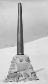 Kiewa Valley Historical Society
Photo: Memorial on the Staircase Spur Track, Mt Bogong
... The Staircase Spur track to its top starts at Mountain Creek Road going through forest and continuing above the snow line to grass land. ...The Staircase Spur track to its top starts at Mountain Creek Road going through forest and continuing above the snow line to grass land. ...Mt Bogong is the highest mountain in Victoria. The Staircase Spur track to its top starts at Mountain Creek Road going through forest and continuing above the snow line to grass land. The weather can change very quickly with cloud and snow making conditions dangerous. Large sepia photo of the Memorial in snow on the Staircase Spur Track on Mt Bogong. The Memorial has a plaque attached: Sacred to the Memory / of Georgine Gadsden / Edward Neave Welch / John McRae / who perished here during a blizzard / about August 2nd 1943staircase spur memorial, mt bogong -
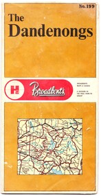 Emerald Museum & Nobelius Heritage Park
Map - Map of the Dandenongs, The Paul Hamlyn Group, c. 1970s
... The other side includes a street index, a list of tourist sites, a list of walking tracks, a map of Sherbrooke Forest, and a map of key approaches from the city to the Dandenongs....The other side includes a street index, a list of tourist sites, a list of walking tracks, a map of Sherbrooke Forest, and a map of key approaches from the city to the Dandenongs. ...George Broadbent was a Geelong-born cyclist record-holder, who produced from 1896 the most comprehensive and detailed maps of Victoria until his death in October 1947. His son had taken over map production in 1945. This map of the Dandenongs c 1970s details tourist sites and walking tracks. This map shows streets and walking tracks and tourist sites significant in the Dandenongs c. 1970s.Front of fold-out map titled 'The Dandenongs No. 199', produced by Broadbents. Folded out, one side is a street map of the Dandenongs. The other side includes a street index, a list of tourist sites, a list of walking tracks, a map of Sherbrooke Forest, and a map of key approaches from the city to the Dandenongs.On front: ' No. 199 / The / Dandenongs / Broadbents / Broadbents / Maps & Guides / A DIVISION OF / THE PAUL HAMLYN / GROUP'broadbents, dandenongs, 1970s, tourist sites, walking tracks -
 Port of Echuca
Coloured Photograph, 04/03/1984
... She has worked in the Wool Industry, the Timber Industry and the Tourist Industry. p.s. adelaide grassie, j.g port of echuca linklater, george poon boon station blair, david murray river darling river logging industry officer brothers. barmah forest fulton & shaw hutchinson, kevin murray downs station blackwood, adelaide On the orange front end loader are the numbers "5900" and the word "case." This is a coloured square photograph of an orange front end loader clearing a track from Hopwood Gardens down to the river. ...The P.S Adelaide was launched on 21st July 1866. It was owned by J.G.Grassie from Poon Boon Station and the Officer Family of Murray Downs Station Swan Hill. The Adelaide was named after the niece of the Officer Bros, Adelaide Blackwood. The shipwright who built her was George Linklater. The Adelaide brought wool and passengers from the wool stations on the Murray and Darling Rivers down to the Echuca Wharf. In 1872 she was sold to David Blair & Sons. She was used to bring timber from the Barmah Forest to the Echuca Wharf. She did this work for the next 80 years. In 1953 she was tied up near the Mill and left. In 1958 she went to Paringa South Australia to work in the sawmill industry again. In 1960 the Echuca Apex Club and The Echuca Historical Society raised enough funds to buy the P.S. Adelaide and return her to Echuca. In November 1963 she was lifted out of the water and placed in Hopwood Gardens as this was thought to be a way of preserving her. In 1984 it was decided to return her to the water to resume work as a passenger vessel. In that time the Port of Echuca and the Echuca Wharf had been restored as a Tourist Precinct. This photograph shows the beginning of the task to return her to the river. It took several weeks in March 1984.The P.S Adelaide is extremely significant as it it the oldest known wooden hulled paddle steamers in the world. She was built in Echuca in 1866 and still operates on the Murray River today. She has worked in the Wool Industry, the Timber Industry and the Tourist Industry.This is a coloured square photograph of an orange front end loader clearing a track from Hopwood Gardens down to the river. The track was used to bring the P.S Adelaide from the gardens back into the river. The P.S Adelaide is in the background. The paddle steamer appears to be up on a trailer of some sort and is surrounded but plastic orange temporary fencing. There are small mounds of soil in the foreground.On the orange front end loader are the numbers "5900" and the word "case." p.s. adelaide, grassie, j.g, port of echuca, linklater, george, poon boon station, blair, david, murray river, darling river, logging industry, officer brothers., barmah forest, fulton & shaw, hutchinson, kevin, murray downs station, blackwood, adelaide -
 Bendigo Military Museum
Photograph - Army Inter-area Orienteering Competition, Kimbolton State Forest, VIC, 1990
... They are part of the Army Survey Regiment’s Collection. .1) to .4) - Photo, colour, 1990, unidentified competitors. .5) - Photo, colour, 1990, L to R: unidentified competitor, Bendigo’s Janet Murray. .6) - Photo, colour, 1990, L to R: unidentified official, Le-Anne (Smallshaw) Shirley, Bendigo’s Janet Murray, unidentified competitors (x2). .7) to .8) - Photo, colour, 1990, unidentified competitors. .9) - Photo, colour, 1990, L to R: unidentified official, Mick Minchin. .10) to .11) - Photo, colour, 1990, Mick Minchin. .12) to .13) - Photo, colour, 1990, Bendigo’s Team L to R: Rene van den Tol, Wolfgang Hofbauer, Mick Minchin, Harris Lee, unidentified competitor, Allan Blake, Janet Murray. .14) & .15) - Photo, colour, 1990, presentations L to R: Rene van den Tol, unidentified competitor. .16) to .19) - Photo, colour, 1990, unidentified competitors. .20) - Photo, colour, 1990, presentations L to R: Rene van den Tol, unidentified competitor. .21) - Photo, colour, 1990, presentations L to R: Rene van den Tol, unidentified competitor, Mick Minchin. .22) - Photo, colour, 1990, BBQ L to R: unidentified (x2), Jeff Rudd, Rene van den Tol, Mick Minchin, Neville Stone, Steve Cooper. .23) - Photo, colour, 1990, BBQ, Wolfgang Hofbauer. .24) - Photo, colour, 1990, BBQ, Janet Murray - in black jacket. .25) - Photo, colour, 1990, BBQ, all unidentified. .26) - Photo, colour, 1990, BBQ, Neville Stone - in green t-shirt, Rene van den Tol in red track suit, remainder unidentified. .27) - Photo, colour, 1990, BBQ L to R: unidentified (x4), Janet Murray, Le-Anne (Smallshaw) Shirley, remainder unidentified. .28) & .29) - Photo, colour, 1990, views of Lake Eppalock. Army Inter-area Orienteering Competition, Kimbolton State Forest ...This set of 29 photographs was taken during Army’s Inter-area Orienteering competition held in the Kimbolton State Forest, near Lake Eppalock, Victoria in 1990. Teams from Albury-Wodonga Bendigo, Broadmeadows, Melbourne Metropolitan, Puckapunyal and Watsonia participated in the annual competition. Bendigo’s Army Survey Regiment led by SGT Mick Minchin hosted the Orienteering events. This set of 29 photographs was taken during Army’s Inter-area Orienteering competition held in Kimbolton State Forest, near Lake Eppalock, Victoria in 1990. The colour photographs are on 35mm negative film and were scanned at 2400 dpi. They are part of the Army Survey Regiment’s Collection. .1) to .4) - Photo, colour, 1990, unidentified competitors. .5) - Photo, colour, 1990, L to R: unidentified competitor, Bendigo’s Janet Murray. .6) - Photo, colour, 1990, L to R: unidentified official, Le-Anne (Smallshaw) Shirley, Bendigo’s Janet Murray, unidentified competitors (x2). .7) to .8) - Photo, colour, 1990, unidentified competitors. .9) - Photo, colour, 1990, L to R: unidentified official, Mick Minchin. .10) to .11) - Photo, colour, 1990, Mick Minchin. .12) to .13) - Photo, colour, 1990, Bendigo’s Team L to R: Rene van den Tol, Wolfgang Hofbauer, Mick Minchin, Harris Lee, unidentified competitor, Allan Blake, Janet Murray. .14) & .15) - Photo, colour, 1990, presentations L to R: Rene van den Tol, unidentified competitor. .16) to .19) - Photo, colour, 1990, unidentified competitors. .20) - Photo, colour, 1990, presentations L to R: Rene van den Tol, unidentified competitor. .21) - Photo, colour, 1990, presentations L to R: Rene van den Tol, unidentified competitor, Mick Minchin. .22) - Photo, colour, 1990, BBQ L to R: unidentified (x2), Jeff Rudd, Rene van den Tol, Mick Minchin, Neville Stone, Steve Cooper. .23) - Photo, colour, 1990, BBQ, Wolfgang Hofbauer. .24) - Photo, colour, 1990, BBQ, Janet Murray - in black jacket. .25) - Photo, colour, 1990, BBQ, all unidentified. .26) - Photo, colour, 1990, BBQ, Neville Stone - in green t-shirt, Rene van den Tol in red track suit, remainder unidentified. .27) - Photo, colour, 1990, BBQ L to R: unidentified (x4), Janet Murray, Le-Anne (Smallshaw) Shirley, remainder unidentified. .28) & .29) - Photo, colour, 1990, views of Lake Eppalock.There are no personnel identified. ‘Inter-Area Orienteering 1990’ annotated on negative sleevesroyal australian survey corps, rasvy, army survey regiment, army svy regt, fortuna -
Federation University Historical Collection
Booklet - Booklet - Media Clippings, University of Ballarat: Community Service Activities, 1994
... Computer and IT programmes; Uni helps kids learn about safe, active, healthy life; Uni eager to foster partnership with local community; Professor David James (Vice Chancellor) to be chair of regional consultation group reforming State's planning system; Ballarat's Martin Hughes of BU Geology Department and Queensland's Neil Phillips to present paper at Geological Society of America in Seattle; Uni to build aquatic centre to attract top swimmers; Open Days planned by Ballarat Universities; Sue Hadden, Ballarat Uni, received $75,000 grant to carry out research on Victoria's disappearing native grasses; Ballarat Uni to host major student sculpture show; Moves to develop high-tech park plan; New Research Plans assisted by Professor Tom O'Donnell; Indian experts look for answers to get more from their depleted desert forests; Uni conducts nursing survey re courses to be offered; Rabbit numbers rise - survey from farmers; Ted Lovett, VFL footballer (Fitzroy) talk on racism in sport at Ballarat Uni.; Australian beer awards at Ballarat Uni.; Study on Unhealthy Fitness - Heart Foundation suggests regular exercise at level suited to individual needs; Survey tracks path of yellow spotting; Tertiary push for hospital - Ararat; University considered for athletics facility; Top-level study on fitness for the elderly to be monitored by Human Movement and Sports Science students, University of Ballarat; Institute of Chartered Accountants will hold its annual accounting information day at the University of Ballarat's Foundation Hall. ...Computer and IT programmes; Uni helps kids learn about safe, active, healthy life; Uni eager to foster partnership with local community; Professor David James (Vice Chancellor) to be chair of regional consultation group reforming State's planning system; Ballarat's Martin Hughes of BU Geology Department and Queensland's Neil Phillips to present paper at Geological Society of America in Seattle; Uni to build aquatic centre to attract top swimmers; Open Days planned by Ballarat Universities; Sue Hadden, Ballarat Uni, received $75,000 grant to carry out research on Victoria's disappearing native grasses; Ballarat Uni to host major student sculpture show; Moves to develop high-tech park plan; New Research Plans assisted by Professor Tom O'Donnell; Indian experts look for answers to get more from their depleted desert forests; Uni conducts nursing survey re courses to be offered; Rabbit numbers rise - survey from farmers; Ted Lovett, VFL footballer (Fitzroy) talk on racism in sport at Ballarat Uni.; Australian beer awards at Ballarat Uni.; Study on Unhealthy Fitness - Heart Foundation suggests regular exercise at level suited to individual needs; Survey tracks path of yellow spotting; Tertiary push for hospital - Ararat; University considered for athletics facility; Top-level study on fitness for the elderly to be monitored by Human Movement and Sports Science students, University of Ballarat; Institute of Chartered Accountants will hold its annual accounting information day at the University of Ballarat's Foundation Hall. ...Booklet of article that appeared in the newspaper outlining events, programmes, etc. that are of community involvement. Computer and IT programmes; Uni helps kids learn about safe, active, healthy life; Uni eager to foster partnership with local community; Professor David James (Vice Chancellor) to be chair of regional consultation group reforming State's planning system; Ballarat's Martin Hughes of BU Geology Department and Queensland's Neil Phillips to present paper at Geological Society of America in Seattle; Uni to build aquatic centre to attract top swimmers; Open Days planned by Ballarat Universities; Sue Hadden, Ballarat Uni, received $75,000 grant to carry out research on Victoria's disappearing native grasses; Ballarat Uni to host major student sculpture show; Moves to develop high-tech park plan; New Research Plans assisted by Professor Tom O'Donnell; Indian experts look for answers to get more from their depleted desert forests; Uni conducts nursing survey re courses to be offered; Rabbit numbers rise - survey from farmers; Ted Lovett, VFL footballer (Fitzroy) talk on racism in sport at Ballarat Uni.; Australian beer awards at Ballarat Uni.; Study on Unhealthy Fitness - Heart Foundation suggests regular exercise at level suited to individual needs; Survey tracks path of yellow spotting; Tertiary push for hospital - Ararat; University considered for athletics facility; Top-level study on fitness for the elderly to be monitored by Human Movement and Sports Science students, University of Ballarat; Institute of Chartered Accountants will hold its annual accounting information day at the University of Ballarat's Foundation Hall. Students from other universities to attend; Prince Edward's visit - challenge of "Great Rubber Tube Raft Regatta" at Lake Wendouree; Uni, company in joint training initiative - installation on Novell's networking software in the degree course; Uni begins study into tree threat; Eureka leadership conference in Ballarat; Leadership conference an outstanding success.Buff coloured cover, black print. Pages glued and bound - black tape. Newspaper articles - photographs and print - on separate sheets in reverse order of appearance in paper; December to February.Symbol of University of Ballarat - cover.computer and it, newspaper items, health, local community involvement, david james, vice chancellor, state's planning system, martin hughes, geology department, neil phillips, queensland university, geological society of america, seattle, aquatic centre, sue hadden, research grant, $75000, native grasses, sculpture exhibitiontom o'donnell, indian experts, nursing survey, rabbit survey, ted lovett, footballer, racism in sport, australian beer awards, unhealthy fitness, heart foundation, athletics facility, fitness for the elderly, human movement and sports science, intitute of chartered accountants, networking system in degree course, eureka leadership conference -
 Orbost & District Historical Society
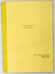
document, BALDWIN SPENCER TRAIL Project Brief 1988, February 1988
... This document was produced by the Department of Conservation, Forests & Land Management, Orbost, to commemorate the visit by Baldwin-Spencer in 1989 as part of the Bicentennial Walking Tracks Project. ...Orbost & District Historical Society Ruskin Street Orbost gippsland This document was produced by the Department of Conservation, Forests & Land Management, Orbost, to commemorate the visit by Baldwin-Spencer in 1989 as part of the Bicentennial Walking Tracks Project. ...This document was produced by the Department of Conservation, Forests & Land Management, Orbost, to commemorate the visit by Baldwin-Spencer in 1989 as part of the Bicentennial Walking Tracks Project. The Baldwin Spencer Trail closely follows the route of scientist and explorer William Baldwin Spencer. Sir Walter Baldwin Spencer KCMG (23 June 1860 – 14 July 1929) was an English-Australian biologist and anthropologist. this booklet is a useful reference tool.A document of 10 pp with a cream cover, titled, Baldwin Spencer Trail Project Brief Feb 1988. It contains mapsbaldwin-spencer -
 Eltham District Historical Society Inc
Photograph, A.C.S.U. Wombelano T.K. 8-9/09/84 with PR
... The Womberlano Falls track is under construction for visitors to enjoy the 1.5 km bushwalk circuit from a near by car park in Kinglake National Park. Wombelano Falls is framed by a eucalypt forest...Eltham District Historical Society Inc 728 Main Rd Eltham melbourne The Womberlano Falls track is under construction for visitors to enjoy the 1.5 km bushwalk circuit from a near by car park in Kinglake National Park. Wombelano Falls is framed by a eucalypt forest ...The Womberlano Falls track is under construction for visitors to enjoy the 1.5 km bushwalk circuit from a near by car park in Kinglake National Park. Wombelano Falls is framed by a eucalypt forest and lush gullies. A.C.S.U. is unidentified but possibly refers to an Association / Australian group of scouts or University studentsTwo colour photographs of working beeacsu, womberlano, kinglake national park, track, construction, working bee -
 Eltham District Historical Society Inc
Photograph - Digital Photograph, Alan King, Kinglake National Park, 27 March 2008
... forest. To manage bushfires, the Committee of Management, then the State Government, worked closely with the Forestry Commission, shire councils and local fire brigades. Early national parks focussed on recreation. But by the 1980s, conservation, education and scientific research became more important, playing a vital role in preserving representative samples of the natural environment. Each year many thousands of people use the park’s extensive network of walking tracks...forest. To manage bushfires, the Committee of Management, then the State Government, worked closely with the Forestry Commission, shire councils and local fire brigades. Early national parks focussed on recreation. But by the 1980s, conservation, education and scientific research became more important, playing a vital role in preserving representative samples of the natural environment. Each year many thousands of people use the park’s extensive network of walking tracks ...Fern gullies around Jehosaphat Gully Covered under National Estate. Published: Nillumbik Now and Then / Marguerite Marshall 2008; photographs Alan King with Marguerite Marshall.; p125 The magnificent Kinglake National Park, fringing Nillumbik’s north, is the largest national park close to Melbourne. Thanks to the vision and hard work of a band of local people, the park was created from what was rapidly becoming degraded land. Seeing a threat to Kinglake’s indigenous flora and fauna, several prominent local people campaigned for a national park, which was established in 1928.1 Since then, the park has grown through donations and acquisitions of land, from around 13,800 acres of land (5585ha) to 22,360 hectares. The Sugarloaf and Everard Blocks – of almost 8000 hectares – stand in Nillumbik and the park extends into Mitchell and Murrundindi Shires and the City of Whittlesea. Mt Everard commemorates William Hugh Everard, State member for Evelyn when the park was established. Before 1928, European settlers had degraded the Kinglake area, which was named after the celebrated English author and lawyer, Alexander William Kinglake. Remains of gold shafts and diggings in the park are reminders of Kinglake’s first settlers, who hoped to strike it rich at the gold diggings. But like other gold fields in this shire, they proved not very lucrative and soon timber cutting replaced mining in importance. However, before long, the accessible timber supply ran out, so in the 1920s agriculture took over – particularly potatoes and berry fruits – which involved large-scale clearing.2 The park’s instigator was retired Melbourne University Professor of Music, William Laver.3 As chair of the Kinglake Progress Association he began negotiations to have crown lands on the southern scarp of the Great Dividing Range reserved as a national park. Even before the park was proclaimed, from 1927, KPA members cut tracks to the major scenic points. Professor Laver was one of several people who gave land for the park, donating around 50 acres (20ha), including the Jehosaphat Gully.4 Laver chaired the park’s first Committee of Management, which raised money to employ a ranger and provide facilities, including tracks and roads for fire protection vehicles, toilets and shelters. The committee charged fees for firewood collection, some grazing of livestock, and visitor entrance, and obtained small State Government and Eltham Shire grants. In 1957 the State Government provided revenue for national parks. Then, in 1975, the State Government took over the management and the Committee of Management became an advisory committee, which disbanded in 1978. Originally, the park covered crown land in the Shires of Eltham and Whittlesea; then Wombelano Falls in Yea and other areas were added. In 1970 the park extended into the Shires of Eltham, Healesville, Whittlesea and Yea.5 Bush fires have been an ongoing problem. In 1939 hundreds of eucalypts and acacias had to be sown around the Jehosaphat Gully to rejuvenate the forest. To manage bushfires, the Committee of Management, then the State Government, worked closely with the Forestry Commission, shire councils and local fire brigades. Early national parks focussed on recreation. But by the 1980s, conservation, education and scientific research became more important, playing a vital role in preserving representative samples of the natural environment. Each year many thousands of people use the park’s extensive network of walking tracks amongst the protected plant and animal life as well as camping, cycling and horse riding. The park, along the slopes of the Great Dividing Range, has lookouts revealing magnificent views of the Melbourne skyline, Port Phillip Bay, the Yarra Valley and the You Yangs. Vegetation in the Masons Falls area includes messmate forest, Austral grass-trees, ferns and Hazel Pomaderris. In spring, orchids, lilies, everlasting daisies, correas, grevillea and heath appear. Around Jehosaphat Gully are wet and dry forest, fern gullies and banksia. Animal life includes wallabies, kangaroos, koalas, echidnas, possums, gliders and bandicoots. Male lyrebirds can be heard mimicking in the Jehosaphat Gully, particularly in the Everard Block in winter.This collection of almost 130 photos about places and people within the Shire of Nillumbik, an urban and rural municipality in Melbourne's north, contributes to an understanding of the history of the Shire. Published in 2008 immediately prior to the Black Saturday bushfires of February 7, 2009, it documents sites that were impacted, and in some cases destroyed by the fires. It includes photographs taken especially for the publication, creating a unique time capsule representing the Shire in the early 21st century. It remains the most recent comprehenesive publication devoted to the Shire's history connecting local residents to the past. nillumbik now and then (marshall-king) collection, kinglake national park, jehosaphat gully -
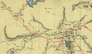 Halls Gap & Grampians Historical Society
Map - Coloured
... Wakeham is credited for the clearing and levelling of the first bridle-path up the gorge. 1870s By the mid 1870s the track had been extended over Valley Gap to the Victoria Forest (the upper region of the Victoria Valley). ...Wakeham is credited for the clearing and levelling of the first bridle-path up the gorge. 1870s By the mid 1870s the track had been extended over Valley Gap to the Victoria Forest (the upper region of the Victoria Valley). ...Background on Bridle Path up Stony Creek Gorge Pre 1840 C. B. Hall, squatter on Mokepilly Run 1841-1842, first European to discover the Fyans Creek valley, the entrance of which became known as Hall's Gap. He later recorded that he followed a number of tracks which he assumed had been made by the Aboriginies and described one as "leading up a wild romantic glen and over on to the source of the Glenelg River". This could well have been the route taken up Stony Creek gorge by the first timber-cutters in this part of the Grampians to the saddle between the Wonderland and Mt. Difficult ranges known as Valley Gap 1850s/60s Timber cutters and shingle splitters were reported to be moving into the eastern side of the Grampians and by the mid 1860s there were a number of families connected to the supplying of timber to Pleasant Creek living in the "Hall's Gap ranges". John Wakeham, the first store owner in Pleasant Creek in 1854, established a timer-mill in upper Stony Creek Gorge in the late 1850s. Wakeham is credited for the clearing and levelling of the first bridle-path up the gorge. 1870s By the mid 1870s the track had been extended over Valley Gap to the Victoria Forest (the upper region of the Victoria Valley). McKeon's bullock team was known to have hauled red gum from the Valley to Stawell in the late 1870s and the 1880s. 1880s In 1887 an article in the Pleasant Creek news describes the Stony Creek Gorge track as "being a ledge alongside the mountain range, formed in the early days with the aid of earth and timber, along which the bullock teams used to travel to Horsham and plains of the Wimmera beyond." 1890s Gold was discovered in the catchment area of Stony Creek and by the end of the 1890s a new track was built from "near the junction of Fyan's and Stony Creeks, up the gorge to the diggings settlement. The mining Department had paid L300 for its construction and, when completed, the track was "three miles and 30 chains in length, the side cuttings at the narrowest part being 10 feet between" and "the watercourses which cross the track at various points" having been "filled up with rocks rolled down the sides of the hills, and consequently there can be no damage caused by bushfires which destroyed the former wooden bridges erected on the old track to Wakeham's saw-mill, the remains of which are still to be seen at the side of the diggings" The article goes on to further describe the track as one which "can with ease travel with a two horse conveyance either up or down" and that the workmen engaged in the construction of the track would be attending "a ball that night at McKeon's farm near the mouth of the gap to celebrate the successful completion of the undertaking". 1900s At what time the bridle path was extended beyond Valley Gap to the Wartook basin on the Mt. Difficult Range has not yet been determined. However, it is known that, by the turn of the century, people were travelling between Halls Gap and the caretakers' residence at Wartook Reservoir along what was now known as the "Bluff Road. Wartook's embankment had been constructed in 1887 and at that time there was already a track from Rosebrook Station homestead (near the present day Wartook Pottery) to the reservoir. Philip Rose owned both Rosebrook and Wartook Stations from the mid 1840s to the late 1850s and had regularly leased the Wartook basin to Cobb & Co. to rest horses there. 1920s Following the war of 1914-1918, tourism really took off in the Grampians, and Halls Gap rapidly grew. People would travel as far as they could on the many tracks then hike to the many lookouts being discovered by local tour guides. This led to the need for access across the range so that horse riders and the increasing number of vehicles could travel between Horsham and Halls Gap. To this end, the Bluff Road was improved and extended on 1929 and at its opening in March, 1930, by Lady Somers it was renamed the Mt. Victory Road.Map of Mt Victory Road and othersaccess routes, mt victory rd, bridle path, roads -
 Halls Gap & Grampians Historical Society
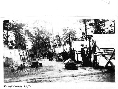
Photograph - Photocopy, C 1936
... After the Depression many hundreds of men worked on building and maintaining roads &: tracks. Some were employed by the Forest Commission of Victoria....After the Depression many hundreds of men worked on building and maintaining roads &: tracks. Some were employed by the Forest Commission of Victoria. ...The relief workers as shown in the photograph were used in the Grampians for logging & road maintenance. After the Depression many hundreds of men worked on building and maintaining roads &: tracks. Some were employed by the Forest Commission of Victoria.people, road gang, structures, tents -
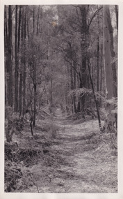
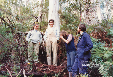
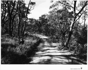 Halls Gap & Grampians Historical Society
Photograph - B/W, C 1960s
... 'Publicity & Public relations Branch, When reproducing please Acknowledge Forests Commission, Victoria, Negative No. 322-14' stamped on back. The photo shows a sandy track through bushland. ...Location unknown.The photo shows a sandy track through bushland.'Forests Commission, Victoria' inscribed on bottom, right of border. 'Publicity & Public relations Branch, When reproducing please Acknowledge Forests Commission, Victoria, Negative No. 322-14' stamped on back.access routes, roads, scenery, grampians ranges