Showing 103 items matching "forests and lands."
-
 Wodonga & District Historical Society Inc
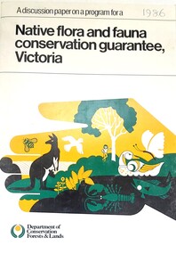
Book - Discussion Paper on Native flora and fauna conservation guarantee, Victoria, Department of Conservation, Forests and Lands, Victoria, 1986
... On bottom of front - Logo Department of Conservation, Forests and Lands...Department of Conservation, Forests and Lands, Victoria ...Discussion Paper on Native flora and fauna conservation guarantee, Victoria Book Discussion Paper on Native flora and fauna conservation guarantee, Victoria Department of Conservation, Forests and Lands, Victoria ...This publication was produce as a discussion paper to inform decisions related to changes in land management and conservation regulations and policy in 1986An A4 size document outlining findings into an investigation into the state of flora and fauna in Victoria.This publication was produce as a discussion paper to inform decisions related to changes in land management and conservation regulations and policy in 1986land management, conservation victoria, water conservation -
 Wodonga & District Historical Society Inc
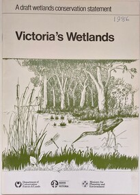
Book - Victoria's Wetlands, Dept. of Conservation, Forests & Lands, 1986
... On foot of cover: Department of Conservation, Forests & Lands, Department of Water Resources, Victoria, Ministry for Planning and Environment...Dept. of Conservation, Forests & Lands...On foot of cover: Department of Conservation, Forests & Lands, Department of Water Resources, Victoria, Ministry for Planning and Environment An 22 page book containing maps and illustrations Victoria's Wetlands Book Victoria's Wetlands Dept. of Conservation, Forests & Lands ...This publication was the result of an inquiry into the state of wetland environments in Victoria. It produced a draft strategy for conservation of threatened areas in the future.An 22 page book containing maps and illustrationsThis publication was the result of an inquiry into the state of wetland environments in Victoria. It produced a draft strategy for conservation of threatened areas in the future.wetland protection, wetlands victoria, water conservation -
 Orbost & District Historical Society
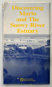
map/brochure, Discovering Marlo & The Snowy River Estuary, December 1988
... In 1983 the Department of Conservation, Forests and Lands replaced the Department of Crown Lands and Survey, the Department of State Forests and the Ministry for Conservation. ...Department of Conservation, Forests and Lands...Orbost & District Historical Society Ruskin Street Orbost gippsland In 1983 the Department of Conservation, Forests and Lands replaced the Department of Crown Lands and Survey, the Department of State Forests and the Ministry for Conservation. ...In 1983 the Department of Conservation, Forests and Lands replaced the Department of Crown Lands and Survey, the Department of State Forests and the Ministry for Conservation. This brochure/map was used as tourist information in Orbost.This item is a useful research tool.A folded map/brochure titled "DISCOVERING MARLO & THE SNOWY RIVER ESTUARY". On the front is a photograph of Marlo and the title in yellow print. There is a locality map for access to Corringle beach and the brochure Includes a key to fishing sites and various tourist locations. On the back of the brochure are notes on fishing, wildlife and a boating guide, map brochure snowy-river marlo -
 Save the Dandenongs League Inc.
Archive (item), Save the Dandenongs League Incorporated, A discussion paper on a program for a Native flora and fauna conservation guarantee, Victoria - Department of Conservation Forests & Lands
... A discussion paper on a program for a Native flora and fauna conservation guarantee, Victoria - Department of Conservation Forests & Lands...A discussion paper on a program for a Native flora and fauna conservation guarantee, Victoria - Department of Conservation Forests & Lands Archive Save the Dandenongs League Incorporated ... -
Save the Dandenongs League Inc.
Document (item), Save the Dandenongs League Incorporated, Save the Dandenongs League Correspondence 1984-1985 [Part 9 of 14]: Dept & Ministry Conserv Forests & Lands
... Save the Dandenongs League Correspondence 1984-1985 [Part 9 of 14]: Dept & Ministry Conserv Forests & Lands...Department of Conservation Forests & Lands Save the Dandenongs League Correspondence 1984-1985 [Part 9 of 14]: Dept & Ministry Conserv Forests & Lands Document Save the Dandenongs League Incorporated ...department of conservation forests & lands -
Save the Dandenongs League Inc.
Document (item), Save the Dandenongs League Incorporated, Save the Dandenongs League Incorporated - January 1986 to September 1986 - Correspondence [Part 4 of 11]: Dept & Mnistry Conserv. Forests & Lands
... Save the Dandenongs League Incorporated - January 1986 to September 1986 - Correspondence [Part 4 of 11]: Dept & Mnistry Conserv. Forests & Lands...Forests & Lands Document Save the Dandenongs League Incorporated ...department of conservation forests & lands -
 Orbost & District Historical Society
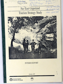
book / document, Far East Gippsland Tourism Strategy Oct 1987, October 1987
... Department of Conservation, Forests and Lands...Far East Gippsland Tourism Strategy Oct 1987 book / document Department of Conservation, Forests and Lands ...The project team for this document comprised E. Beacham, T. Claridge, B. Ebbs, C. Wilso. and J. Cristofaro.This booklet is a useful refernce tool.A document of 86 pp, titled Far East Gippsland Tourism Strategy Study Interim Report October 1987. it has a cream cover and black binding with a b/w photograph of four people in a bushland setting. It contains fold-out maps.tourism-east-gippsland -
 Orbost & District Historical Society
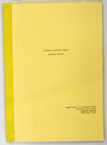
document, BALDWIN SPENCER TRAIL Project Brief 1988, February 1988
... Department of Conservation, Forests and Lands...It contains maps BALDWIN SPENCER TRAIL Project Brief 1988 document Department of Conservation, Forests and Lands ...This document was produced by the Department of Conservation, Forests & Land Management, Orbost, to commemorate the visit by Baldwin-Spencer in 1989 as part of the Bicentennial Walking Tracks Project. The Baldwin Spencer Trail closely follows the route of scientist and explorer William Baldwin Spencer. Sir Walter Baldwin Spencer KCMG (23 June 1860 – 14 July 1929) was an English-Australian biologist and anthropologist. this booklet is a useful reference tool.A document of 10 pp with a cream cover, titled, Baldwin Spencer Trail Project Brief Feb 1988. It contains mapsbaldwin-spencer -
 Eltham District Historical Society Inc
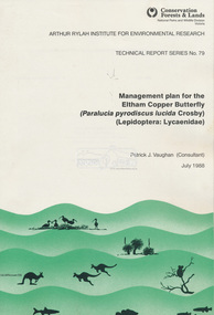
Book, Pat Vaughan, Management plan for the Eltham Copper Butterfly (Paralucia pyrodiscus lucida Crosby), (Lepidoptera: Lycasenidae); Arthur Rylah Institute for Environmental Researcg, Technical Report Series No. 79, July 1988
... ...Conservation Forests & Lands, National Parks and Wildlife Division, Victoria...Eltham District Historical Society Inc 728 Main Rd Eltham melbourne Soft cover bound A4, 54 pages Management plan for the Eltham Copper Butterfly (Paralucia pyrodiscus lucida Crosby), (Lepidoptera: Lycasenidae); Arthur Rylah Institute for Environmental Researcg, Technical Report Series No. 79 Book Book Pat Vaughan Conservation Forests & Lands, National Parks and Wildlife Division, Victoria ... -
 Marysville & District Historical Society
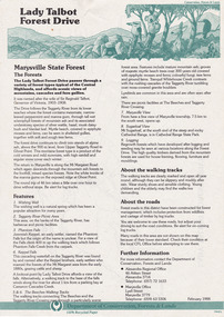
Flyer (item) - Information Flyer, Department of Conservation, Forests & Lands, Lady Talbot Forest Drive, February 1988
... Department of Conservation, Forests & Lands...Lady Talbot Forest Drive Flyer Information Flyer Department of Conservation, Forests & Lands ...A flyer with information on Lady Talbot Forest Drive and the attractions in the area surrounding it.A flyer with information on Lady Talbot Forest Drive and the attractions in the area surrounding it. Lady Talbot Drive a 24 kilometer scenic rainforest car journey which passes a number of walks and waterfalls in the Yarra Ranges National Park. Lady Talbot Drive is named after Lady Sarah Elizabeth, the wife of Sir Reginald Talbot, who was the Governor of Victoria from 25th April, 1904 to 6th July 1908.7761(F1)lady talbot drive, lady talbot forest drive, marysville state forest, sir reginald talbot, lady sarah elizabeth talbot, wishing well, taggerty river, phantom falls, keppel falls, beeches walking track, marysville, mount sugarloaf, logging, victoria, walking tracks -
 Marysville & District Historical Society
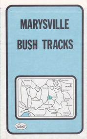
Map (Item) - Bush tracks map, John Siseman et al, MARYSVILLE BUSH TRACKS, 1987
... Management Directory Conservation, Forests and Lands...MARYSVILLE BUSH TRACKS Map Bush tracks map John Siseman Glenn van der Knijff Management Directory Conservation, Forests and Lands Pindari Publications Algona Publications ...A fold out map of the bush tracks in and around Marysville with information regarding each track. This map was published by Pindari Publications and distributed by Algona Publications. The track notes were compiled by John Siseman in 1987. The map was drawn by Glenn van der Knijff.A fold out map of the bush tracks in and around Marysville with information regarding each track.marysville, victoria, australia, map, bush tracks, pindari publications, algona publications, john siseman, gleen van der knijff, lady talbot forest drive, beauty spot walk, michaeldene track, steavenson falls, tree fern gully walk, trestle track, phantom falls, marysville town walk, marysville lookouts round walk, keppel falls, the beeches round walk, cumberland scenic reserve, cambarville, lake mountain, lake mountain walking track -
Lakes Entrance Historical Society
Book, A Study of Land in the Catchment of the Gippslnd Lakes Vol 1, 1988
... Department of Conservation Forests and Lands Victoria...Lakes Entrance Historical Society 4 Marine Parade Lakes Entrance gippsland 108 printed pages in report, wire spiral bound DOCUMENTS Reports Blue cardboard cover with title printed in gold A Study of Land in the Catchment of the Gippslnd Lakes Vol 1 Book Department of Conservation Forests and Lands Victoria ...108 printed pages in report, wire spiral boundBlue cardboard cover with title printed in golddocuments, reports -
Lakes Entrance Historical Society
Book, Department of Conservation Forests and Lands, Management Alternatives for Gippsland Lakes 1989, 1989
... Department of Conservation Forests and Lands...Management Alternatives for Gippsland Lakes 1989 Book Department of Conservation Forests and Lands ...Provides information and inviting public comment and discussion on the management of the Gippsland Lakes Victoria.wetlands, recreation, waterways -
University of Melbourne, Burnley Campus Archives
Document - Conference Papers, Conservation Forests & Lands, Second Landcare Community Conference, 14-15.07.1989
... Conservation Forests & Lands...Second Landcare Community Conference Document Conference Papers Conservation Forests & Lands ...conference, landcare, conservation, community -
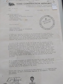 Peterborough History Group
Document - Three letters pertaining to the retention of the Old Bridge
... Two A4 Typewritten letters, one from the Road Construction Authority to the National Trust Australia, the other from the Department of Conservation Forests & Lands to Mr John Irvine. And one hand written letter....RCA letter is stamped "Received 22 Aug 1985", Dept of Conservation Forests & Lands has a pencilled phone no inscribed....Its sentimental value saw locals attempt (although unsuccessfully) to retain the old bridge. peterborough curdies river bridge old peterborough bridge department of conservation forest & lands road construction authority RCA letter is stamped "Received 22 Aug 1985", Dept of Conservation Forests & Lands has a pencilled phone no inscribed. ...Upon confirmation that a new bridge was to be built, there was some discussion about the possibility of retaining the old bridge for pedestrian purposes, or part of the old bridge as a fishing platform. These letters are part of the correspondence re an organisation taking responsibility for the ongoing maintenance so the old bridge could be retained.The old bridge was constructed of locally sourced timber and was such an important structure to the town when built. Its sentimental value saw locals attempt (although unsuccessfully) to retain the old bridge.Two A4 Typewritten letters, one from the Road Construction Authority to the National Trust Australia, the other from the Department of Conservation Forests & Lands to Mr John Irvine. And one hand written letter.RCA letter is stamped "Received 22 Aug 1985", Dept of Conservation Forests & Lands has a pencilled phone no inscribed.peterborough, curdies river bridge, old peterborough bridge, department of conservation forest & lands, road construction authority -
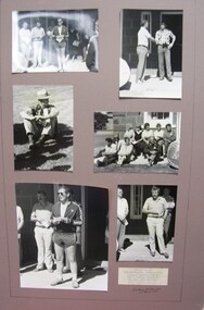 Glenelg Shire Council Cultural Collection
Photograph - Photograph - Montage. Handover Ceremony of Portland Section of Great South West Walk to Department Conservation Forrest and Land, 13/04/1986
... Photographic Montage of handing over of Portland section of Great South West Walk, to the Department Conservation, Forests and Lands....Front: Bottom Right: Sticker, typed Handing over to Depatment,Conservation, Forests and Lands following inaugurul walk on City of Portland Section of the Great South West Walk. ...Photographic Montage of handing over of Portland section of Great South West Walk, to the Department Conservation, Forests and Lands. Photograph Photograph - Montage. ...Glenelg Shire Council RecordsPhotographic Montage of handing over of Portland section of Great South West Walk, to the Department Conservation, Forests and Lands.Front: Bottom Right: Sticker, typed Handing over to Depatment,Conservation, Forests and Lands following inaugurul walk on City of Portland Section of the Great South West Walk. (now a complete circuit) Signature in pen Grahame McDonald 13th April 1986. -
 Department of Energy, Environment and Climate Action
Pye Portable radio and charger
... Conservation Forests and Lands Wangaratta...But it was the convergence of separate technologies such as 5G mobile phones, high-capacity and light-weight lithium batteries, Wi-Fi, the ever-expanding internet, cloud data storage, digital cameras, GPS, personal organisers and hundreds of supporting Apps into powerful smartphones and tablets which revolutionised bushfire communications from the mid-2000s. Bushfire Radios Forests Commission Victoria (FCV) Conservation Forests and Lands Wangaratta Portable radio with handset and charger Pye Portable radio and charger ...After the 1939 bushfires, the Forests Commission Victoria invested heavily in a radically new communications network. After suffering some inevitable delays due to the war, radio VL3AA switched into full operation in October 1945 proudly beaming out 200 watts across the State. But by today’s standards, the technology was primitive and the reception poor unless the user was on a high point somewhere. The radio signal was "line-of-sight" and bounced between fire towers and relay transmitters across the mountains back to the District offices. The advent of solid-state electronics in the 1960s replaced the more delicate valve sets which enabled greater use of vehicle mounted radios. The Commission continued to research, develop and build new radios at its many workshops around Victoria. The network was supported by a large team of skilled radio technicians. The more secure and versatile State Mobile Radio (SMR) digital trunk system came into operation in about 1995. Upgraded Tait Radios were purchased in 2014 after recommendations of the 2009 Bushfires Royal Commission. But it was the convergence of separate technologies such as 5G mobile phones, high-capacity and light-weight lithium batteries, Wi-Fi, the ever-expanding internet, cloud data storage, digital cameras, GPS, personal organisers and hundreds of supporting Apps into powerful smartphones and tablets which revolutionised bushfire communications from the mid-2000s. Portable radio with handset and chargerConservation Forests and Lands Wangarattabushfire, radios, forests commission victoria (fcv) -
 Rutherglen Historical Society
Document - License to thin trees, 1899 (Exact)
... "Department of Lands and Survey. On Forest Business"...Secretary for Lands, Department of Lands and Survey / On Forest Business...On back, copy of Land Act Regulations 1890 Document License to thin trees Secretary for Lands, Department of Lands and Survey / On Forest Business ...Dated July 14th 1899. Sent to Mr W. Cooper / c/o Mr Barrie / Storekeeper / No. 2 Valley / Chiltern / "Copy of Land Act 1896 / Regulations. Chapter XI Thinning Licenses"Document on stiff paper. Letter to Mr W. Cooper granting license to thin trees on a block of land at Chiltern Reserve. On back, copy of Land Act Regulations 1890"Department of Lands and Survey. On Forest Business"license, timber felling, cooper family, forestry, chiltern reserve -
 Department of Energy, Environment and Climate Action
Motorola Syntax radio
... Conservation Forests and Lands Colac Region 09/209...But it was the convergence of separate technologies such as 5G mobile phones, high-capacity and light-weight lithium batteries, Wi-Fi, the ever-expanding internet, cloud data storage, digital cameras, GPS, personal organisers and hundreds of supporting Apps into powerful smartphones and tablets which revolutionised bushfire communications from the mid-2000s. Bushfire Radios Forests Commission Victoria (FCV) Conservation Forests and Lands Colac Region 09/209 Radio with handset Motorola Syntax radio ...After the 1939 bushfires, the Forests Commission Victoria invested heavily in a radically new communications network. After suffering some inevitable delays due to the war, radio VL3AA switched into full operation in October 1945 proudly beaming out 200 watts across the State. But by today’s standards, the technology was primitive and the reception poor unless the user was on a high point somewhere. The radio signal was "line-of-sight" and bounced between fire towers and relay transmitters across the mountains back to the District offices. The advent of solid-state electronics in the 1960s replaced the more delicate valve sets which enabled greater use of vehicle mounted radios. The Commission continued to research, develop and build new radios at its many workshops around Victoria. The network was supported by a large team of skilled radio technicians. The more secure and versatile State Mobile Radio (SMR) digital trunk system came into operation in about 1995. Upgraded Tait Radios were purchased in 2014 after recommendations of the 2009 Bushfires Royal Commission. But it was the convergence of separate technologies such as 5G mobile phones, high-capacity and light-weight lithium batteries, Wi-Fi, the ever-expanding internet, cloud data storage, digital cameras, GPS, personal organisers and hundreds of supporting Apps into powerful smartphones and tablets which revolutionised bushfire communications from the mid-2000s. Radio with handsetConservation Forests and Lands Colac Region 09/209bushfire, radios, forests commission victoria (fcv) -
Lakes Entrance Historical Society
Map - Forest of Victoria
... Shows Mountain Forest, Alpine woodlands and grassy lands, Alpine Ash Forest, Mountain Ash and Gum Forest, Stringybark, Ironbark, Redgum Forest all Victoria...Forest Grassy Land Shows Mountain Forest, Alpine woodlands and grassy lands, Alpine Ash Forest, Mountain Ash and Gum Forest, Stringybark, Ironbark, Redgum Forest all Victoria Map Forest of Victoria ...Shows Mountain Forest, Alpine woodlands and grassy lands, Alpine Ash Forest, Mountain Ash and Gum Forest, Stringybark, Ironbark, Redgum Forest all Victoriaforest, grassy land -
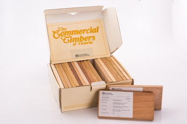 Department of Energy, Environment and Climate Action
Commercial timbers of Victoria, Sample Box
... Labeling and boxing was done by FCV Timber Inspectors, with box and booklet design and graphics handled in-house More recent timber samples were badged as Conservation Forests & Lands, reflecting historical government restructuring in the early 1980s Info: Simon Murphy...Each timber specimen has information on species, occurrence, uses and physical properties Produced for sale by the the FCV and later by the Department of Conservation Forests and Lands. (CFL). ...Each timber specimen has information on species, occurrence, uses and physical properties Produced for sale by the the FCV and later by the Department of Conservation Forests and Lands. (CFL). Sample Box Commercial timbers of Victoria ...Some decades ago a card sorting set for the identification and description of Australian timbers was developed for timber species which were available commercially and were in common usage, by the Commonwealth of Australia (CSIRO, Division of Forest Products) To complement and inform this national timber set each State or Territory developed reference timber sets of representative species. The Commercial Timbers of Victoria set was Victoria’s most recent (circa 1984) expression of this Victorian timber samples were sourced from logs selected by Forest Commission of Victoria (FCV) District Foresters and milled locally. Kiln drying and machining was carried out at timber producers Row, Web and Anderson, in Port Melbourne. Labeling and boxing was done by FCV Timber Inspectors, with box and booklet design and graphics handled in-house More recent timber samples were badged as Conservation Forests & Lands, reflecting historical government restructuring in the early 1980s Info: Simon MurphyProvided the public, industry (timber and associated), and educational facilities with a reference collection of notable Victorian timbers. Initially in a reduced format from 1940-50s, with boxed sets produced from 1981 until 1984A boxed set of timber samples representing the 20 tree species that were considered to be the most notable in Victoria. The set also includes an information booklet. Each timber specimen has information on species, occurrence, uses and physical properties Produced for sale by the the FCV and later by the Department of Conservation Forests and Lands. (CFL). forests commission victoria (fcv) -
 Whitehorse Historical Society Inc.
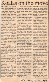
Article, Koalas on the move, 14/01/1986 12:00:00 AM
... Article from 'The Post' 14 January 1986 about relocation of koalas by the Department of Conservation, Forests and Lands....Whitehorse Historical Society Inc. 2-10 Deep Creek Road Mitcham melbourne wildlife koalas victoria. department of conservation forests and lands Article from 'The Post' 14 January 1986 about relocation of koalas by the Department of Conservation, Forests and Lands. ...Article from 'The Post' 14 January 1986 about relocation of koalas by the Department of Conservation, Forests and Lands.Article from 'The Post' 14 January 1986 about relocation of koalas by the Department of Conservation, Forests and Lands.Article from 'The Post' 14 January 1986 about relocation of koalas by the Department of Conservation, Forests and Lands.wildlife, koalas, victoria. department of conservation forests and lands -
 Lakes Entrance Historical Society
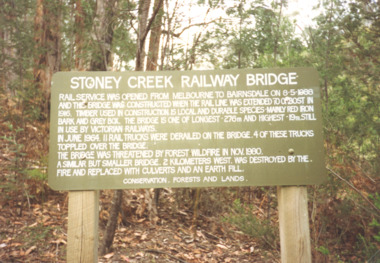
Photograph - Stoney Creek Bridge Nowa Nowa Victoria, Davies Judy, c1990
... Colour photograpf of the sign erected by the Conservation, Forests and Lands Dept. at the Stoney Creek Bridge Nowa Nowa Victoria . ...Lakes Entrance Historical Society 4 Marine Parade Lakes Entrance gippsland Bridges Forestry Tourism Topography Colour photograpf of the sign erected by the Conservation, Forests and Lands Dept. at the Stoney Creek Bridge Nowa Nowa Victoria . ...Colour photograpf of the sign erected by the Conservation, Forests and Lands Dept. at the Stoney Creek Bridge Nowa Nowa Victoria . Plus two other photos of the bridgebridges, forestry, tourism, topography -
 Stawell Historical Society Inc
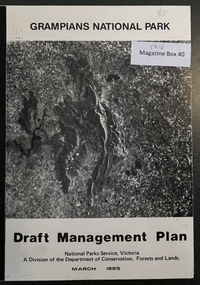
Book - Report, Grampians National Park Draft Management Plan, 1985
... A Division of the department of Conservation, Forest and Lands...A Division of the department of Conservation, Forest and Lands $5 Barry Clugston Soft Cover with B/W Photo of aerial view of ranges of Grampians. ...For Public comment to National Park Service, Victoria. A Division of the department of Conservation, Forest and LandsSoft Cover with B/W Photo of aerial view of ranges of Grampians. Black taped Spine binding.$5 Barry Clugston -
 City of Ballarat Libraries
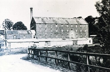
Photograph - Card Box Photographs, Anderson's Mill, Smeaton circa 1960
... Acquired by the then Dept of Conservation Forests & Lands who restored the building & replaced long iron shed with timber veranda....City of Ballarat Libraries Eureka Centre Eureka Street Ballarat East goldfields Acquired by the then Dept of Conservation Forests & Lands who restored the building & replaced long iron shed with timber veranda. ...Acquired by the then Dept of Conservation Forests & Lands who restored the building & replaced long iron shed with timber veranda.anderson's mill, smeaton, building, manufacturing, vehicle -
Federation University Historical Collection
Reports, Unidentified Mammal Report, 1970-1990, 1970-1990
... The folder or correspondence is the result of a Freedom of Information request made to the Department of of Conservation, Forests and Lands in 2011. The folder was collected for research being conducted by David Waldron....Barker Library (top floor) Mount Helen goldfields The folder or correspondence is the result of a Freedom of Information request made to the Department of of Conservation, Forests and Lands in 2011. The folder was collected for research being conducted by David Waldron. australian mythical animals collection david waldron thylacine sassafras peter monhorst jodie hoey kelvin smith traralgon south gormondale bridgewater g. mcclure whorouly albury jim walker andrea westcott john dawson nicole walsh grampians eddy scott talbot lancefield kalorama inglewood gavin cerini dereel rosemary fernandez brian walters alexandra unidentified mammel romsey bill butterworth flowerdale bob hoare trafalgar lyn demopolis broadford green gully ian weir noel pascoe bruce carter mount stirling andrea cooper stawell yvonne shepherd red hills halls gap jill reid puma w.r.c. hill caelli Folder of reports relating to "Big Cats", Thylacines, and other large predators sightings Unidentified Mammal Report, 1970-1990 Reports ...The folder or correspondence is the result of a Freedom of Information request made to the Department of of Conservation, Forests and Lands in 2011. The folder was collected for research being conducted by David Waldron.Folder of reports relating to "Big Cats", Thylacines, and other large predators sightings australian mythical animals collection, david waldron, thylacine, sassafras, peter monhorst, jodie hoey, kelvin smith, traralgon south, gormondale, bridgewater, g. mcclure, whorouly, albury, jim walker, andrea westcott, john dawson, nicole walsh, grampians, eddy scott, talbot, lancefield, kalorama, inglewood, gavin cerini, dereel, rosemary fernandez, brian walters, alexandra, unidentified mammel, romsey, bill butterworth, flowerdale, bob hoare, trafalgar, lyn demopolis, broadford, green gully, ian weir, noel pascoe, bruce carter, mount stirling, andrea cooper, stawell, yvonne shepherd, red hills, halls gap, jill reid, puma, w.r.c. hill, caelli -
Clunes Museum
Administrative record - BOOK, DEPARTMENT OF LANDS AND SURVEY, LICENCE
... LOCALITY - ALL CROWN LANDS, NOT BEING IN STATE FORESTS OR RESERVES FOR ANY SPECIAL PURPOSE. ...LOCALITY - ALL CROWN LANDS, NOT BEING IN STATE FORESTS OR RESERVES FOR ANY SPECIAL PURPOSE. ...RECEIPTS ISSUED BY DEPARTMENT OF LANDS AND SURVEY TO CUT AND TAKE AWAY WOOD. ISSUED EACH QUARTER. LOCALITY - ALL CROWN LANDS, NOT BEING IN STATE FORESTS OR RESERVES FOR ANY SPECIAL PURPOSE. GUM, STRINGYBARK, BOX, MESSMATE AND OTHER KINDS OF EUCALYPTUS TIMBER EXCEPTING RED GUM AND IRON BARK.BLUE CARDBOARD COVERED BOOK CONTAINING TIMBER LICENCES FOR ORDINARY WOOD, COSTING 5/- .1 ISSUED 1886 - 1887 RECEIPT NUMBERS 181901 - 181925 .2 ISSUED 1885 - 1886 RECEIPT NUMBERS 185276 - 185300 DETAILS OF NAMES OF PERSONS LICENCES ISSUED TO ATTACHED TO BACK OF BOOKSlocal history, receipt books, early citizens, wood licences -
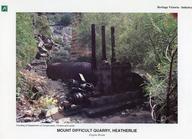 Stawell Historical Society Inc
Photograph, Heatherlie Quarry -- Coloured
... Courtesy of Department of Conservation, Forests and Lands. Mount Difficult Quarry, Heatherlie Engine Room On reverse information about Mount Difficult Quarry, Heatherlie, including two photgraphs....Courtesy of Department of Conservation, Forests and Lands. Mount Difficult Quarry, Heatherlie Engine Room On reverse information about Mount Difficult Quarry, Heatherlie, including two photgraphs. ...Coloured Photo Heatherlie QuarryColour Photograph of old engine and brick chimney surrounded by trees."Heritage Victoria - Industry" on top right. Unknown Logo on top Left. Courtesy of Department of Conservation, Forests and Lands. Mount Difficult Quarry, Heatherlie Engine Room On reverse information about Mount Difficult Quarry, Heatherlie, including two photgraphs.stawell grampians industry -
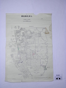 Ballan Shire Historical Society
Map - Map. Bungal, Department of Lands and Survey, Bungal, County of Grant, 09/09/1926
... Lithographed at the Department of Lands and Survey. Melbourne by W. J. Butson on 9.9.1926. ...Bungal. Department of Lands and Survey. ...A map of Bungal in the 1920's showing the allotments, and the size, with the names of the residents. It shows the roads and the Western and Eastern Moorarbool River, and the Whipstick State Forest.Cream coloured map of Bungal in the County of Grant, bounded by the the East Moorarbool River on the East, and the State Forest on the South. It is marked with the scale of chains and the number L.358. Lithographed at the Department of Lands and Survey. Melbourne by W. J. Butson on 9.9.1926. It shows the land allotments with names of owners.Coloured pen marks and circled numbers on various areas. Price 2 shillings marked on bottom right hand edge.bungal, kerrit bareet, egerton, lal lal, borhoneyghurk, bungeeltap, ballark, yaloak, gorong, moorarbool west -
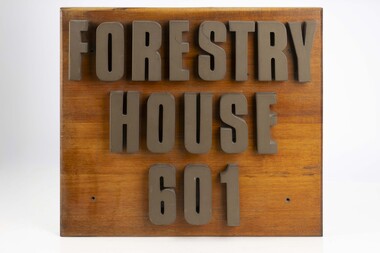 Department of Energy, Environment and Climate Action
Forestry House Sign
... Forestry House was the fist time that Forests Commission Head office staff had been housed in a purpose built building in Melbourne 601 Bourke street is on the corner of Bourke and King streets The building opened in the late 1970s but staff relocated in the late 1980s after the formation of the Department of Conservation Forests and Lands (CFL)...Department of Energy, Environment and Climate Action 71-79 Kyle Road Altona North Forestry House was the fist time that Forests Commission Head office staff had been housed in a purpose built building in Melbourne 601 Bourke street is on the corner of Bourke and King streets The building opened in the late 1970s but staff relocated in the late 1980s after the formation of the Department of Conservation Forests and Lands (CFL) Forests Commission Victoria (FCV) Forest Signs Large wooden sigh from outside Forestry House at 601 Bourke Street Forestry House Sign ...Forestry House was the fist time that Forests Commission Head office staff had been housed in a purpose built building in Melbourne 601 Bourke street is on the corner of Bourke and King streets The building opened in the late 1970s but staff relocated in the late 1980s after the formation of the Department of Conservation Forests and Lands (CFL)Large wooden sigh from outside Forestry House at 601 Bourke Streetforests commission victoria (fcv), forest signs