Showing 73 items matching "gardens drainage"
-
 University of Melbourne, Burnley Campus Archives
Letter, S. Allan Johnson, c. 1971
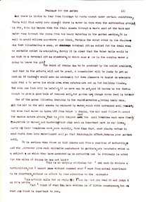
... ...gardens drainage...It is undated , and suggests that two authors are Mr Lothian and Miss N Chisholm, graduates of Burnley offer incorrect information on drainage in gardens. He includes 3 pages of instructions on drainage in gardens. ...The brown paper envelope is addressed to the Burnley Horticultural Gardens, Burnley and is not postmarked. There is no stamp. (Hand delivered.) s. allan johnson drainage gardens drainage incorrect garden drainage criticism of garden drainage practice horticulture drainage instructions Letter to Director, Burnley School of Horticulture re drainage Letter Letter S. ...Critical letter to Director from S. Allan Johnson re drainage. This letter (original and carbon copy) is addressed to the Director School of Horticulture Burnley. It is from S. Allan Johnson who gives the address of Henry George League, 18 George Parade, Melbourne. It is undated , and suggests that two authors are Mr Lothian and Miss N Chisholm, graduates of Burnley offer incorrect information on drainage in gardens. He includes 3 pages of instructions on drainage in gardens. There is a handwriten note on the back of the copy. The letter is full of typing and spelling mistakes. The brown paper envelope is addressed to the Burnley Horticultural Gardens, Burnley and is not postmarked. There is no stamp. (Hand delivered.) Letter to Director, Burnley School of Horticulture re drainage s. allan johnson, drainage, gardens drainage, incorrect garden drainage, criticism of garden drainage practice, horticulture drainage instructions -
 Warrnambool and District Historical Society Inc.
Financial record - Ledger: Warrnambool Water works Trust, Circa 1900
... Similar supplies were also installed at Albert Park, the Botanic Gardens and the Cattle markets and from 1893 to 1939 water was drawn from the Merri River. Drainage...Similar supplies were also installed at Albert Park, the Botanic Gardens and the Cattle markets and from 1893 to 1939 water was drawn from the Merri River. Drainage ...This ledger contains entries which relate to waterworks and associated expenses: construction, pumping schemes, water from stand pipes, meter rent arrears, interest payments, pumping scheme. Early residents in Warrnambool relied on tanks and wells for their water supply and in 1880 the first water supply scheme was implemented from a well on Cannon Hill. Using a windmill the water was pumped up and stored in a small reservoir nearby then piped to the corner of Timor and Liebig Streets where a stand pipe allowed the filling of water carts. Similar supplies were also installed at Albert Park, the Botanic Gardens and the Cattle markets and from 1893 to 1939 water was drawn from the Merri River. Drainage works commenced with the building of the Japan Street tunnel in 1856. The Warrnambool Waterworks Trust was the body responsible for administering these works.The supply and storage of fresh water and drainage of the area was an important factor in the development and sustainability of the town. This ledger provides an insight into the daily operations of this organisation. Large suede covered journal. Tan in colour with pink, green and white on edge of pages. Faded black stylised border around front cover. Inside front covers are patterned in green and tan. Printed sheet with Warrnambool waterworks Trust is pasted inside front cover. Warrnambool Waterworks Trust stamp on sheet inside front cover.warrnambool water works, warrnambool water supply 1900, warrnambool water works ledger 1900, warrnambool waterworks trust -
 Eltham District Historical Society Inc
Photograph - Digital Photograph, Alan King, Diamond Creek, Barak Bushlands, Eltham, 2008
... Part of it was used as a cow paddock and although small patches of vegetation survived, the area was infested with weeds, rabbits, rubbish and drainage from the housing estate. At various times the 4.4 hectares had been used as a market garden and for shire stock piles. ...Part of it was used as a cow paddock and although small patches of vegetation survived, the area was infested with weeds, rabbits, rubbish and drainage from the housing estate. At various times the 4.4 hectares had been used as a market garden and for shire stock piles. ...A habitat corridor and it strengthens the community. Published: Nillumbik Now and Then / Marguerite Marshall 2008; photographs Alan King with Marguerite Marshall.; p185 Barak Bushlands lie west of the Diamond Creek on the corner of Falkiner Street and busy, noisy Main Road. They form part of an important habitat corridor linking the Yarra River to the Kinglake National Park.1 Manna Gums, tawny frogmouths and platypuses are some of the indigenous plants and animals that have made their home there. The bushlands are the result of more than nine years of hard work by the local community with the Nillumbik Council, to transform a degraded flood plain into this refuge of natural beauty. In 1997, shortly after moving into the new Riverside Estate on Falkiner Street, Eltham, several residents noticed the sorry state of the Diamond Creek and surrounding area. Part of it was used as a cow paddock and although small patches of vegetation survived, the area was infested with weeds, rabbits, rubbish and drainage from the housing estate. At various times the 4.4 hectares had been used as a market garden and for shire stock piles. The residents began to restore the area by revegetating land along the Diamond Creek. In 1998 they established the Friends of the Diamond Creek Falkiner Street Reserve2 and 35 families joined from the 90-house Estate. Carolyn Mellor, as the Friends’ Land Manager, undertook a four-year horticulture course to guide this massive project for a volunteer organisation. Since 1999, she has been the Friends’ President. In 1999 the Friends urged the Nillumbik Council to undertake a feasibility study into establishing a wetland system and urban forest. Work began in 2002 with Nillumbik Council funding the project, supplemented by government grants. The Friends also received grants from Melbourne Water and Parks Victoria. Aided by the Friends and other community members, the Council created the Barak Bushlands consisting of a forest, a wetland, a bridge, a path and open space. The beautiful wetland treats most of the estate’s stormwater runoff. Storm water is filtered through plants in the wetland ponds then is released slowly into the billabong, before flowing into the Diamond Creek. The wetland also helps to minimise flooding and the improved water quality provides a flora and fauna habitat. The Friends and other volunteers planted more than 27,000 plants, more than one third of which they grew from seeds they collected at Lower Eltham and Wingrove Parks. Eltham High School students planted thousands of these through a Year Eight program introduced for this purpose. Other groups who assisted were: Green Corps, local Scouts and Guides – 2nd Montmorency, 1st Diamond Creek and 1st Eltham Cub Packs, Eltham College students, Eltham East Primary School, Landcare members, Eltham Lions Club and the Eltham Baptist Church. To maintain enthusiasm for the mammoth task, the Friends and other volunteers ‘adopted’ trees to water and wrote their names on the stakes. In 2004, to recognise the area’s original occupiers, the reserve was named Barak Bushlands. William Barak, who lived from 1824 to 1903, was the last chief of the Yarra Yarra tribe of the Wurundjeri-willam people. Traces of these original inhabitants remain in scar trees (bark sections removed to make a shield or canoe). That same year the Friends’ group was a finalist in the prestigious Federal Government, Banksia Environmental Awards. The Friends have also participated in Clean Up Australia, removing tonnes of rubbish and regularly testing the billabong, wetland and creek, for pollutants. For years the Friends, together with the Australian Platypus Conservancy, have tagged, measured and checked the health of platypuses from the Diamond and Mullum Mullum Creeks. With Latrobe University the Friends have conducted night walks to view owls, possums, bats and sugar gliders. Challenges for the council and the Friends continue with a large rabbit population, some vandalism, weed eradication and maintenance. However, thanks to this community effort, locals can now escape confined urban living on small blocks of land and enjoy the beauty of indigenous plants and animals. Working together has also strengthened the local community,This collection of almost 130 photos about places and people within the Shire of Nillumbik, an urban and rural municipality in Melbourne's north, contributes to an understanding of the history of the Shire. Published in 2008 immediately prior to the Black Saturday bushfires of February 7, 2009, it documents sites that were impacted, and in some cases destroyed by the fires. It includes photographs taken especially for the publication, creating a unique time capsule representing the Shire in the early 21st century. It remains the most recent comprehenesive publication devoted to the Shire's history connecting local residents to the past. nillumbik now and then (marshall-king) collection, barak bushlands, diamond creek (creek), eltham -
 Glen Eira Historical Society
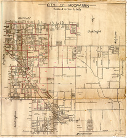
Document - GARDENVALE
... Gardenvale Bent Thomas Brighton Caulfield Elsternwick Railway stations Lempriere family ‘Bentville’ Lempriere’s Paddock Market gardens Nepean Highway Nepean Road North Road Kooyong Road Polo Sheridan family Bluestone houses Bethlehem Hospital Land subdivision Begonia Street Gardenia Road Gardenia Street Magnolia Street Lantana Street Martin Street Shops ‘Ben Burb’ House names Padua Hospital Brighton O’Neill Miss O’Neill College O’Neill Richard O’Neill Estate Elster Avenue O’Neill College Estate Railway Crescent Denver Crescent Brentani Avenue College Street Rosstown Railway Brighton Cemetery Ross Mr Hawthorn Road Ormond Gardenvale Progress Association Elster Creek Parliamentary representatives Landscapes Gardenvale Road Railway lines Subways Traders Association Drainage Floods Document GARDENVALE ...This file contains two items about Gardenvale, which was previously all part of Caulfield: 1/Photocopied eight page document by M. Stewart, 1961, entitled ‘The Gardenvale Story’. It describes Gardenvale Railway and surrounding roads and land. Lempriere’s Paddock, rail tracks on the main roads for the use of market gardeners’ wagons. Sale of land for O’Neill College Estate and construction of a subway through the railway embankment to Gardenvale Shopping centre, including efforts by local people and the council for work to be completed and costs. Footnote is circa 1977. 2/Map of Glen Eira printed from Council website 20/06/2014 showing Glen Eira’s share of Gardenvale.gardenvale, bent thomas, brighton, caulfield, elsternwick, railway stations, lempriere family, ‘bentville’, lempriere’s paddock, market gardens, nepean highway, nepean road, north road, kooyong road, polo, sheridan family, bluestone houses, bethlehem hospital, land subdivision, begonia street, gardenia road, gardenia street, magnolia street, lantana street, martin street, shops, ‘ben burb’, house names, padua hospital, brighton, o’neill miss, o’neill college, o’neill richard, o’neill estate, elster avenue, o’neill college estate, railway crescent, denver crescent, brentani avenue, college street, rosstown railway, brighton cemetery, ross mr, hawthorn road, ormond, gardenvale progress association, elster creek, parliamentary representatives, landscapes, gardenvale road, railway lines, subways, traders association, drainage, floods -
 Eltham District Historical Society Inc
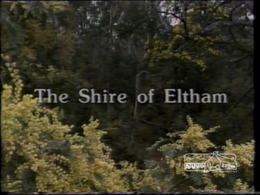
Film - Video (VHS), IMP Productions, The Shire of Etham - The Evergreen Shire (Series 69, Item 4), c.1985
... garden...horse riding...housing estates...hurstbridge...infant welfare centre...john cohen...kangaroo ground...local history centre...montmorency...montsalvat...mudbrick...parks and gardens...peck's dam...pigeon bank...police residence...river of life banner...riverclay...road drainage...Also the Living and Learning Centre, St Andrews Markets and other local markets, the Eltham Leisure Centre, cricket and horse riding at Eltham Lower Park, the Infant Welfare Centre (part of the Eltham War Memorial), how residents are mindful of protecting their historical heritage, the CBA bank and Allwood House at Hurstbridge, Tracey Naughton about the Eltham "As we are" Community Banner project and the “River of Life banner”, the Parks and Gardens office in the former Police Residence building (now the Local History Centre), Alistair Knox Park, road planning and types of roads, tree canopy, Peck's Dam, green carparks, road drainage, Gordon Ford's garden and natural landscapes, and Were Street shops in Montmorency. ...Also the Living and Learning Centre, St Andrews Markets and other local markets, the Eltham Leisure Centre, cricket and horse riding at Eltham Lower Park, the Infant Welfare Centre (part of the Eltham War Memorial), how residents are mindful of protecting their historical heritage, the CBA bank and Allwood House at Hurstbridge, Tracey Naughton about the Eltham "As we are" Community Banner project and the “River of Life banner”, the Parks and Gardens office in the former Police Residence building (now the Local History Centre), Alistair Knox Park, road planning and types of roads, tree canopy, Peck's Dam, green carparks, road drainage, Gordon Ford's garden and natural landscapes, and Were Street shops in Montmorency. ...Shire of Eltham Archives: Series 69, Item 4 This video was produced for the Shire of Eltham by IMP Productions and provides a description of the shire, 277 square km on a north/northeast axis, some 25 km northeast of the centre of Melbourne with a population of around 40,000. Scenes include Yarra River, rural settings and urban settings, housing estates, Shillinglaw Cottage, Pigeon Bank at Kangaroo Ground, the Eltham Railway Trestle Bridge with reference to the fight by locals in the 1970s to save it from replacement, Montsalvat, mudbrick making and its use as a building material, the use of mudbrick in the Eltham Community Centre blending harmoniously with the environment. Emphasises people living in the area due to the qualities of life provided. Also the Living and Learning Centre, St Andrews Markets and other local markets, the Eltham Leisure Centre, cricket and horse riding at Eltham Lower Park, the Infant Welfare Centre (part of the Eltham War Memorial), how residents are mindful of protecting their historical heritage, the CBA bank and Allwood House at Hurstbridge, Tracey Naughton about the Eltham "As we are" Community Banner project and the “River of Life banner”, the Parks and Gardens office in the former Police Residence building (now the Local History Centre), Alistair Knox Park, road planning and types of roads, tree canopy, Peck's Dam, green carparks, road drainage, Gordon Ford's garden and natural landscapes, and Were Street shops in Montmorency. Planning for shopping facilities and carparks with a population of 40,000 growing to 55,000, Arthur Street Mall and carpark, local village feel in the shopping centre. Councillors and Council staff featured include Mary Grant, Bob Manuell, Rodney Roschellor, John Cohen, Alan Baker. Also scenes of Commercial Place, Diamond Valley Railway, Eltham Galley, Riverclay and canoeing on the Yarra intermingled with images of the shire from the Shire of Eltham Pioneers Photograph collection.VHS Video cassette Converted to MP4 file format 00:11:56; 79MBshire of eltham, video recording, shire of eltham archives, alistair knox park, allwood house, arthur street, arthur street mall, bob manuell, canoeing, carparks, cba bank, commercial place, council staff, councillors, cr. mary grant, cricket, diamond valley railway, eltham community banner project, eltham community centre, eltham galley, eltham leisure centre, eltham living and learning centre, eltham lower park, eltham railway trestle bridge, eltham war memorial, gordon ford garden, horse riding, housing estates, hurstbridge, infant welfare centre, john cohen, kangaroo ground, local history centre, montmorency, montsalvat, mudbrick, parks and gardens, peck's dam, pigeon bank, police residence, river of life banner, riverclay, road drainage, road planning, rodney roschellor, shillinglaw cottage, shire of eltham pioneers photograph collection, st andrews market, tracey naughton, tree canopy, were street, yarra river, alan baker -
 Bendigo Historical Society Inc.
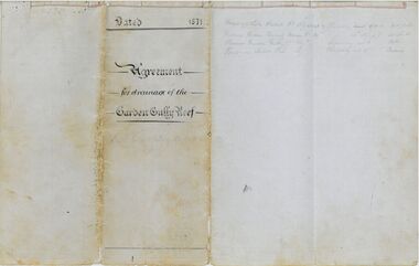
Legal record - Hartnell Legal Documents: Agreement for Drainage of the Garden Gully Reef 1871
... Hartnell Legal Documents: Agreement for Drainage of the Garden Gully Reef 1871...Agreement and Subscription Schedule for Drainage of the Garden Gully Reef 1871 2 pieces of lined A3 paper folded to make a 4 page book bound with string. ...South Garden Gully Sandhurst. Agreement and Subscription Schedule for Drainage of the Garden Gully Reef 1871 2 pieces of lined A3 paper folded to make a 4 page book bound with string. ...Agreement and Subscription Schedule for Drainage of the Garden Gully Reef 1871 2 pieces of lined A3 paper folded to make a 4 page book bound with string. Document handwritten in black ink on blue lined paper with red margins. When closed the book was then folded in 4 to create a pamphlet. The document has extensive notes written in pencil, which are difficult to read. The document also has two water marks. On the cover page is a crest with the initials EE underneath. All other pages have the second which reads R. Barnard 1850. The document makes use of 2 types of seals, a red wax seal and a variety of stamps which indented the paper. The stamps read as follows: 1. Victoria Queen Quartz Mining Co. Registered Bendigo 1870 2. Garden Gully Reef Extended Co. Registered Bendigo. 3. (difficult to read) Sandhurst and Registered are visible. 4. The Premier Garden Gully Company Registered Sandhurst 5. The Queen of Sheba Tribute Co. Registered 1871 6. Victoria Queen Tribute Co. Registered Bendigo. 7. Cemetery Reserve Company Sandhurst Registered 1871 8. Premier Tribute Co. South Garden Gully Sandhurst.the bank of victoria, the victoria queen quartz mining company, jean baptiste loridan, john augustus woodward, the garden gully reef, garden gully reef extended co, victoria queen quartz mining co, the premier garden gully company, the queen of sheba tribute co, victoria queen tribute co., cemetery reserve company, premier tribute co. south garden gully -
Port Melbourne Historical & Preservation Society
Map, City of Port Melbourne, Oct 1963
... Port Melbourne Historical & Preservation Society Port Melbourne Town Hall 333 Bay Street Port Melbourne melbourne Gives a visual understanding of the Port Melbourne area in 1963 local government built environment piers and wharves natural environment - beaches and foreshore parks and gardens piers and wharves - princes pier piers and wharves - station pier engineering - roads streets lanes and footpaths engineering - canals and drainage A detailed map of the Port Melbourne area in October 1963. ...Gives a visual understanding of the Port Melbourne area in 1963A detailed map of the Port Melbourne area in October 1963. Details roads and laneways, undeground cables, light and power poles, sewer, bridges, piers reserve and park areas.local government, built environment, piers and wharves, natural environment - beaches and foreshore, parks and gardens, piers and wharves - princes pier, piers and wharves - station pier, engineering - roads streets lanes and footpaths, engineering - canals and drainage -
Port Melbourne Historical & Preservation Society
Photograph - Railway Reserve, Sandridge, William Paterson, 1870s
... Gardens Sydney Sims ANDERSON Town Clerks Railway Reserve Station Street "P. Anderson" ink, on back:"10" ballpoint, on upper left face of photo View from pedestrian bridge over railway, looking southeast over 'ornamental' Railway Reserve, 1870s. Probably taken from footbridge just north of Raglan Street; open space is believed to be swamp drainage ...One of a series assembled for the Melbourne Exhibition of 1873, original mount hanging in Engineering Department at Port Melbourne Town Hall at 19-9-1994. This set of prints belonged to Town Clerk Syd ANDERSON, then to his daughter-in-law Phyllis ANDERSON (donor). Accompanied by list of captions, both hand written and typed (the latter a partial listing). View from pedestrian bridge over railway, looking southeast over 'ornamental' Railway Reserve, 1870s. Probably taken from footbridge just north of Raglan Street; open space is believed to be swamp drainage area between Raglan and Spring Street. (Location usually attributed to Farrell Street - i.e. taken from footbridge at Bridge and Station, but this proves unlikely as there had been no construction on the swamp between Bridge and Farrell until later.)"P. Anderson" ink, on back:"10" ballpoint, on upper left face of phototransport - railways, built environment, parks and gardens, sydney sims anderson, town clerks, railway reserve, station street -
Port Melbourne Historical & Preservation Society
Book - Town of Port Melbourne, Arthur Victor Heath, Town Surveyor et al, Surveyors Report Book, 1901
... Sandridge Lagoon Local Government - Town of Port Melbourne Fishermans Bend Flood Fire and Fire Services Port Melbourne Town Hall Transport - Horse Transport - Tramways Parks and Gardens Engineering - Roads Streets Lanes and Footpaths Excelsior Hall Societies Clubs Unions and other Organisations Built Environment Industry - Manufacturing Engineering - Canals and Drainage Crimes and Misdemeanours Transport - Ferries South Melbourne Arthur Victor HEATH George BEAZLEY H V CHAMPION Business and Traders - Hotels Stamped inside cover and on some pages, 'Town of Port Melbourne Surveyors Office' Book of reports of Port Melbourne Town Surveyor 1901-1911: 475 pp volume bound in dark green with maroon spine and corners. ...Reports to Council hand entered by Town Surveyor and ATS, with marginal notes on actions taken by Council.Book of reports of Port Melbourne Town Surveyor 1901-1911: 475 pp volume bound in dark green with maroon spine and corners. Gold stamped on spine 'Minute Book' but added leather label below reads 'Surveyors Report Book'. Some inserts (glued in)Stamped inside cover and on some pages, 'Town of Port Melbourne Surveyors Office'sandridge lagoon, local government - town of port melbourne, fishermans bend, flood, fire and fire services, port melbourne town hall, transport - horse, transport - tramways, parks and gardens, engineering - roads streets lanes and footpaths, excelsior hall, societies clubs unions and other organisations, built environment, industry - manufacturing, engineering - canals and drainage, crimes and misdemeanours, transport - ferries, south melbourne, arthur victor heath, george beazley, h v champion, business and traders - hotels -
 Bendigo Historical Society Inc.
Document - DRAINAGE PROBLEMS - BURST WATER MAIN UNDER GARDEN GULLY SANDHEAP
... DRAINAGE PROBLEMS - BURST WATER MAIN UNDER GARDEN GULLY SANDHEAP...Drainage Problems... Burst Water Main under Garden Gully Sandheap...Document DRAINAGE PROBLEMS - BURST WATER MAIN UNDER GARDEN GULLY SANDHEAP ...Handwritten notes from a Bendigo Advertiser report 7 Jan 1907. Three shifts of men working all Saturday and Sunday had not located the main. A large are of Eaglehawk and the City are without water. Had to timber a hole to a depth of 25 ft. Victoria Quartz, Windmill Hill, Needle, Confidence Ext'd, Princess Dagmar, Golden Age, Golden Pyke, Macduff, constellation, Gt Northern, (partly), Specimen Hill, Clarence, New Argus, Comet, Gt Central Victoria and Victoria Consols had to close because they had no water and five to six hundred men believed to be out of work. City Council will put water-carts on and supply residents free of charge. New Moon, South Moon, Virginia , Catherine and Devonshire mines get their water direct from the water race so they did not close down. Document from Albert Richardson Collection of mining history.gold, drainage problems, drainage problems, burst water main under garden gully sandheap, bendigo advertiser, 7/1/1907, victoria quartz, windmill hill, needle, confidence ext'd, princess dagmar, golden age, golden pyke, macduff, constellation, gt northern, (partly), specimen hill, clarence, new argus, comet, gt central victoria, victoria consols, north johnsons, johnson's reef, snobs hill line, new moon south moon, virginia, catherine, devonshire, albert richardson -
 Bendigo Historical Society Inc.
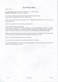
Document - MINING REPORTS - ENGINEDRIVERS & EIGHT HOURS DAY 1873
... ... South Garden Gully Drainage Coy...History House 11 Mackenzie Street Bendigo goldfields BHS Collection Gold mining reports Mining Reports Enginedrivers & Eight Hours Day Bendigo Advertiser 2/6/1873 Engineers and Enginedrivers Association Royal Hotel Young Chum Co Comet Co Robin Hood Co Fraser's Crushing Engine Rainbow Tribute Garden Gully United New Chum & Belle Vue Ext'd Richard Heales Tribute Ellesmere Coy Koch's & Hildebrandt South Garden Gully Drainage Coy Napoleon Tribute Victoria Gold Mines Coy Golden Empire Lazarus Mine Handwritten notes by Albert Richardson (also typed copy) from Bendigo Advertiser Report Monday June 2nd 1873. ...BHS CollectionHandwritten notes by Albert Richardson (also typed copy) from Bendigo Advertiser Report Monday June 2nd 1873. Notes mention Engineers and Engine-drivers Association meeting at Royal Hotel on 31/5/1873. Threat of strike if 8 hour day not granted. Names companies who had agreed to the 8 hours, wages and no reduction in wages.gold, mining reports, mining reports, enginedrivers & eight hours day, bendigo advertiser 2/6/1873, engineers and enginedrivers association, royal hotel, young chum co, comet co, robin hood co, fraser's crushing engine, rainbow tribute, garden gully united, new chum & belle vue ext'd, richard heales tribute, ellesmere coy, koch's & hildebrandt, south garden gully drainage coy, napoleon tribute, victoria gold mines coy, golden empire, lazarus mine -
 Bendigo Historical Society Inc.
Document - MINING REPORTS - MINING RECORD FEB., 1862
... Items mentioned are:- Epsom and Huntly Leads, Pottery Flat, & c, Parliamentary Intelligence, Deep Sinking On Quartz Reefs, The Comet Company (Formerly Cooper's Little Redan), Hustler's Reef Quartz Mining & Drainage Company, Sailors' Gully Quartz Mining Company, Star Reef, Sailor's Gully, Bendigo, Star Reef Quartz Mining Company's Claim, Wilson & Co's Claim, Murdoch and Co's Claim, Hollick and Co.'s Claim, Cook and Co.'s Claim, Coote and Co.'s Claim, Sailor's gully quartz Mining Company's Claim, Garden...Items mentioned are:- Epsom and Huntly Leads, Pottery Flat, & c, Parliamentary Intelligence, Deep Sinking On Quartz Reefs, The Comet Company (Formerly Cooper's Little Redan), Hustler's Reef Quartz Mining & Drainage Company, Sailors' Gully Quartz Mining Company, Star Reef, Sailor's Gully, Bendigo, Star Reef Quartz Mining Company's Claim, Wilson & Co's Claim, Murdoch and Co's Claim, Hollick and Co.'s Claim, Cook and Co.'s Claim, Coote and Co.'s Claim, Sailor's gully quartz Mining Company's Claim, Garden ...Photocopy of pages 2, 3, 4, 6 to 10 of The Mining Record, Feb. 1862. Items mentioned are:- Epsom and Huntly Leads, Pottery Flat, & c, Parliamentary Intelligence, Deep Sinking On Quartz Reefs, The Comet Company (Formerly Cooper's Little Redan), Hustler's Reef Quartz Mining & Drainage Company, Sailors' Gully Quartz Mining Company, Star Reef, Sailor's Gully, Bendigo, Star Reef Quartz Mining Company's Claim, Wilson & Co's Claim, Murdoch and Co's Claim, Hollick and Co.'s Claim, Cook and Co.'s Claim, Coote and Co.'s Claim, Sailor's gully quartz Mining Company's Claim, Garden Gully Reef, Knobel & Co.'s Claim, Ladams and Co.'s Claim, Southern Cross Company, The Rainbow Company, Barry and Co.'s Claim, Union Company's Claim, Winterbottom and Co.s Claim, Jury and Co.'s Claim, Piles and Co.'s Claim, Steers and Co.'s Claim, Watson and Co.'s Claim, Coles and Co.'s Claim, James and Co.'s Claim, Morgan, Kirchner and Co.'s Claim, Boyd and Co.'s Claim, Shanks and Co.'s Claim, Day and Co.'s Claim, Brown and Co.'s Claim, St. Mungo Quartz Mining Company and the Nelson Reef Quartz Mining Company.document, gold, mining reports, mining record feb 1862, bell's life, wellington hotel, botanical gardens, mitchell gardens, bird-in-hand, independent co, ballarat co, perserverance co, north star co, all england co, macleod co, mather and co, gold washing co, bendigo valley co, robey and co, hobbs and co, taylor's, lewis and co, henwood and co, bullock and co, davey and co, webb and lathlean, the welshman's, bon accord, john thomas's, caledonian co, webster, hrdy bros, mcewen and co, the big engine co, epsom huntly and ironstone hill co, 'the thames' steamer, whitely and co, cambridge co, victoria co, dower m'intosh and co, thomas and davies, aurora co, brett's, thomas bros, mitchell brothers, ballarat co, north star co, all england co, mr b g davies, mr ramsay, dr evans, tarrangower times, mr humffray, clunes co, mr courtin, mr lawrence, port phillip and colonial gold mining co, mr bland, r brough smith, john s mcnair, john mathieson, mr r o smith, joseph millen, thomas kaye, john basset, william cook, james cousley, john hill, robert hollinger, thomas houston, george loudon, william manning, john matthews, john mcewen, thomas milligan, john moorhead, robert moorhead, david murdoch, andrew murdoch, joseph nevin, edward o'malley, wm newton paul, james reid, samuel robinson, jesse selwood, james shand, william woods, catherine united claimholders, star reef co, sailor's gully co, churchill davidson, wm wilson, john jervis, james patterson, john carmont, george m'naughten, alexander wiseman, james houston, m'lennan, clark, thomas hollick, james alfred bowles, john lampert, francis palmetser, nichols, little pumping engine co, m'niely, morrison, waight, john coote, robert hamilton, william wilson, john jervis, southern cross co, ladam's claim, knobel, bird, philip ladams, james anderson, cordon, ashley, godwin, burkamp, john lomasney, james bryant, matthew langridge, benjamin exley, j r finlayson, wormold, mccartney, schrade, schumacher, george barry, james patten, peter speares, thomas caley, shadbolt, john lomasney, peat, kenely, mcgenely, egan, exwell, james winterbottom, john winterbottom, william jury, jonathan laidman, john pile, simon howard, peter morris, bignall, charles robison, ferguson, thomas steers, adolphe witts, albert berchdolt, richard urand, thomas watson, klemm, boyd, abbot, peterson, taylor, henry day, walter wallan, brown, grennan, day, young, mr beckwith, joseph thomson, nelson reef quartz mining co -
 Bendigo Historical Society Inc.
Document - VICTORIA HILL - THE BENDIGO DIGGINGS, PRELIMINARY DRAFT FOR BROCHURE
... History House 11 Mackenzie Street Bendigo goldfields BHS Collection MINING Marketing victoria hill Victoria Hill The Bendigo Diggings - Preliminary Draft for Brochure Aust National Travel Association Tullamarine Jetport Emu Bottom Homestead Kyneton Historical Museum Chinese Joss House Eaglehawk Museum Whipstick Scrub Cairn Curran Reservoir Castelmaine Historical Museum and Market Hall National Trust Ballarat Hiatorical Park Echuca's Hopwood Gardens Swan Hill Folk Museum Gibson's Mount Alexander No 2 Squatting Run Captain Brown Chief Commissioner Wright Hustler's Reef Thomas Hustler Mining Board Drainage of Reefs Act 1862 First World War Bendigo Amalgamated Goldfields Second World War Sandhurst W C Vahland Battery Trams Horse Trams Steam Trams Electric Trams Central Nell Gwynne Mine Theodore Ballerstadt George Lansell New Chum Hill Ballerstadt's Open Cut 180 Mine New Chum Syncline Battery William Rae Victoria Quartz Wittscheibe's 'Jeweller's Shop' Luffsman and Sterry Gold Mines Hotel Adventure Bendigo and District Tourist Association Bendigo City Council Bendigo Branch of the Royal Historical Society of Victoria Professor Brian Lewis School of Architecture and Building at the University of Melbourne Taylor Horsfield Lord Robert Cecil South Australian Gold Commissioner Nine typed pages of notes on a preliminary draft for a brochure on the Bendigo Diggings. ...BHS CollectionNine typed pages of notes on a preliminary draft for a brochure on the Bendigo Diggings. First part is the objective which is to preserve the mining history and to have exhibits in the places they were used, e.g. quartz mining machinery exhibited in a quartz mining area, not on an alluvial field. Part B is historical notes on the area. Part C is the Site - Victoria Hill area. Part D is Stage One which consists of carpark area, technological museum, restaurant, mineral haulage line, picnic ground, earthworks and planting over the area. Part E is Stage Two which will consist of the open-air exhibits, in the area surrounded by the mineral haulage line, and the Central Nell Gwynne mine on the west side of the site. Part F is Stage Three which will consist of the winery, the steam tram track, the lake, the wildlife sanctuary and various buildings associated with gold mining. Part G is Costing with the prices to be filled in. Parts H and I are the Appeal and the Committee. Details to be filled in. Notes prepared by Albert Richardson.mining, marketing, victoria hill, victoria hill, the bendigo diggings - preliminary draft for brochure, aust national travel association, tullamarine jetport, emu bottom homestead, kyneton historical museum, chinese joss house, eaglehawk museum, whipstick scrub, cairn curran reservoir, castelmaine historical museum and market hall, national trust, ballarat hiatorical park, echuca's hopwood gardens, swan hill folk museum, gibson's mount alexander no 2 squatting run, captain brown, chief commissioner wright, hustler's reef, thomas hustler, mining board, drainage of reefs act 1862, first world war, bendigo amalgamated goldfields, second world war, sandhurst, w c vahland, battery trams, horse trams, steam trams, electric trams, central nell gwynne mine, theodore ballerstadt, george lansell, new chum hill, ballerstadt's open cut, 180 mine, new chum syncline battery, william rae, victoria quartz, wittscheibe's 'jeweller's shop', luffsman and sterry, gold mines hotel, adventure, bendigo and district tourist association, bendigo city council, bendigo branch of the royal historical society of victoria, professor brian lewis, school of architecture and building at the university of melbourne, taylor horsfield, lord robert cecil, south australian gold commissioner -
 Bendigo Historical Society Inc.
Document - NORMAN OLIVER COLLECTION: MAYOR'S NOTES 1964
... Topics include : a council business meeting dealing with the use of the Garden Gully sports facilities, the Housing Commission garden competition, Royal Commission on supply and consumption of liquor, neighbourhood disputes regarding drainage issues and owner responsibility, Rotary Club slide presentation on Bendigo past and present, tenders to Council for supply of a range of materials, Art Gallery Committee meeting (noting the need for careful selection policy re. donations and borrowings)....Topics include : a council business meeting dealing with the use of the Garden Gully sports facilities, the Housing Commission garden competition, Royal Commission on supply and consumption of liquor, neighbourhood disputes regarding drainage issues and owner responsibility, Rotary Club slide presentation on Bendigo past and present, tenders to Council for supply of a range of materials, Art Gallery Committee meeting (noting the need for careful selection policy re. donations and borrowings). ...The Norman Oliver collection. Norman Oliver was three times Mayor of Bendigo - 1950-51, 1964-65, 1970-71. 1. Two covering pages, with handwriting in blue pen. Mayor's Notes 1964, and Contents of File - Mayor's Notes 1964, Bendigo, Local Government, Town Planning, Water - Coliban Area, Business - marketing, etc., Speech for Graduation of Nurses. 2. Four typed pages of undated Mayor's Notes which make reference to the first week as Mayor, and learning of his appointment on 29 August. Topics include : a council business meeting dealing with the use of the Garden Gully sports facilities, the Housing Commission garden competition, Royal Commission on supply and consumption of liquor, neighbourhood disputes regarding drainage issues and owner responsibility, Rotary Club slide presentation on Bendigo past and present, tenders to Council for supply of a range of materials, Art Gallery Committee meeting (noting the need for careful selection policy re. donations and borrowings).bendigo, council, speech notes, norman joseph oliver , councillor norman oliver. mayor of bendigo. bendigo art gallery. rotary clubs - bendigo. royal commission on supply and consumption of liquor. -
 Ringwood and District Historical Society
Book, City of Ringwood, City of Ringwood 1994 Report & Community Guide, 1994
... Margaret Cheevers 3 Your Council 4 Local State and Federal MPs 5 Council Meetings and Elections 6 History of Ringwood 7 City Manager's Report 8 Organisational structure 9 Human Services 10-19 Environmental Health 20-21 Ringwood Library 22 Parks and Gardens 23 Ringwood's Parks and Reserves 24 Building 25 Engineering Planning Services 26-28 Waste Management 29 Town Planning 30 Traffic and Local Laws 31-33 Roads, Drainage and Major Works 38-39 Halls and Facilities 40-41 Aquatic Centre 42 Convention Centre/Karralika Theatre 43 Golf Course 44 Free Swim & Golf Discount Vouchers 45 Community Organisations 46-64 Finance 65-66 Administration 67 Community Liaison 68 Information Systems 69 Personnel 70-71 Risk Management 71 Rates and Valuations 72 ...Margaret Cheevers 3 Your Council 4 Local State and Federal MPs 5 Council Meetings and Elections 6 History of Ringwood 7 City Manager's Report 8 Organisational structure 9 Human Services 10-19 Environmental Health 20-21 Ringwood Library 22 Parks and Gardens 23 Ringwood's Parks and Reserves 24 Building 25 Engineering Planning Services 26-28 Waste Management 29 Town Planning 30 Traffic and Local Laws 31-33 Roads, Drainage and Major Works 38-39 Halls and Facilities 40-41 Aquatic Centre 42 Convention Centre/Karralika Theatre 43 Golf Course 44 Free Swim & Golf Discount Vouchers 45 Community Organisations 46-64 Finance 65-66 Administration 67 Community Liaison 68 Information Systems 69 Personnel 70-71 Risk Management 71 Rates and Valuations 72 Community information book issued by City of Ringwood for 1994 - covering the facilities and activities of the Ringwood Council and other local organisations and associations. ...The City of Ringwood and the City of Croydon merged in December 1994 and became the City of Maroondah.Community information book issued by City of Ringwood for 1994 - covering the facilities and activities of the Ringwood Council and other local organisations and associations. Includes Ringwood Public Golf Course discount vouchers and two Ringwood Aquatic Centre bonus entry vouchers.CONTENTS: (page no.) Contents A Message from the Mayor - Cr. Margaret Cheevers 3 Your Council 4 Local State and Federal MPs 5 Council Meetings and Elections 6 History of Ringwood 7 City Manager's Report 8 Organisational structure 9 Human Services 10-19 Environmental Health 20-21 Ringwood Library 22 Parks and Gardens 23 Ringwood's Parks and Reserves 24 Building 25 Engineering Planning Services 26-28 Waste Management 29 Town Planning 30 Traffic and Local Laws 31-33 Roads, Drainage and Major Works 38-39 Halls and Facilities 40-41 Aquatic Centre 42 Convention Centre/Karralika Theatre 43 Golf Course 44 Free Swim & Golf Discount Vouchers 45 Community Organisations 46-64 Finance 65-66 Administration 67 Community Liaison 68 Information Systems 69 Personnel 70-71 Risk Management 71 Rates and Valuations 72 rinx -
 City of Moorabbin Historical Society (Operating the Box Cottage Museum)
Certificate - Wedding Certificate Alonzo Box, June 1918
... Alonzo Box, who lived in Oakleigh, was the nephew of William and Elizabeth Box, pioneer market gardeners who resided in 'Box Cottage' 1865 -1914 His occupation is stated as "Pitcher Setter' i.e one who laid pavers, (Pavior), or blue-stone pitchers. It would have been a specialised work requiring skills much the same as a brick layer. In a developing Shire this would have been a very necessary job used in gutter laying, drainage ...Original Marriage Certificate of Alonzo and Mary Box nee Closter (Kloster) June 12th 1918. Alonzo was the nephew of William and Elizabeth Box who settled in Moorabbin Parish in 1865 and developed a market garden and raised their family . On the Marriage Certificate Mary Box has spelt her Maiden name "Closter" with a "C" and not the " K" of her German heritage. Albert and Maria Kloster nee Bolch, were German immigrant Gardeners and Mary was born in Mount Waverley ,Victoria 1889. This marriage was taking place during World War 1 when many immigrants would have altered the spelling of their name.Alonzo Box, who lived in Oakleigh, was the nephew of William and Elizabeth Box, pioneer market gardeners who resided in 'Box Cottage' 1865 -1914 His occupation is stated as "Pitcher Setter' i.e one who laid pavers, (Pavior), or blue-stone pitchers. It would have been a specialised work requiring skills much the same as a brick layer. In a developing Shire this would have been a very necessary job used in gutter laying, drainage works etc.. Original Marriage Certificate of Alonzo and Mary Box nee Closter (Kloster) June 12th 1918 enclosed in a glass covered, wooden frame.'In the State of Victoria/ - (Coat of Arms) - In the Commomwealth of Australia/ FOURTH SCHEDULE, ACTS Nos. 2691 and 2720, - FORM B/ CERTIFICATE OF MARRIAGE/ with date and signatures of participants.brighton, moorabbin, anglican, box william, box elizabeth, box alonzo, box mary, box john, box martha, pitcher setter, pavoir, oakleigh, government victoria, german immigrants -
 City of Moorabbin Historical Society (Operating the Box Cottage Museum)
Map - Maps, T. H. Putt Real Estate Bentleigh, c 1940's
... drainage system. The maps in the book were most likely from the maps produced in the mid 1930’s. Some of the MMBW maps have had extra subdivisions and information, such as measurements, owners names, and street names have been added. There are four maps which have been hand drawn and cover the part of East Bentleigh bordered by East Boundary Road, Centre Road, Warrigal Road and South Road. At the time this area was still market gardens...gardens of the City of Moorabbin. Example of the progress of the Municipality of Moorabbin Putt Real Estate moorabbin bentleigh Bentleigh east cheltenham hampton brighton mckinnon MMBW Melbourne metropolitan board of works maps T. H. Putt A black folder containing 29 pages of maps of the suburbs of the City of Moorabbin. The maps are sections of Melbourne and Metropolitan Board of Works (MMBW) plans which were produced from the 1890s to the 1950s. These maps were used to the design and development of Melbourne's sewerage and drainage ...The train line from the city to Frankston was electrified in 1922 which intensified the sale in the municipality of Moorabbin, particularly land which was in the vicinity of the railway stations. A local Real Estate agent, T. H. Putt used the maps to assist with the selling of the subdivisions of market gardens of the City of Moorabbin. Example of the progress of the Municipality of MoorabbinA black folder containing 29 pages of maps of the suburbs of the City of Moorabbin. The maps are sections of Melbourne and Metropolitan Board of Works (MMBW) plans which were produced from the 1890s to the 1950s. These maps were used to the design and development of Melbourne's sewerage and drainage system. The maps in the book were most likely from the maps produced in the mid 1930’s. Some of the MMBW maps have had extra subdivisions and information, such as measurements, owners names, and street names have been added. There are four maps which have been hand drawn and cover the part of East Bentleigh bordered by East Boundary Road, Centre Road, Warrigal Road and South Road. At the time this area was still market gardens. The maps have been mounted on material by J. Creffield Pty Ltd, 171 King Street, Melbourne Victoria. Creffield Pty Ltd, was a firm of map mounters, heliographers and printers, which commenced business in 1988. The company still operates today (2025) in West Melbourne as Creffield Digital Print. putt, real estate, moorabbin, bentleigh, bentleigh east, cheltenham, hampton, brighton, mckinnon, mmbw, melbourne metropolitan board of works, maps, t. h. putt -
 Ballarat Tramway Museum
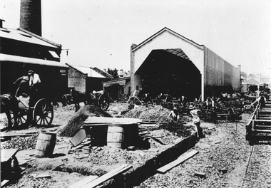
Photograph - Geelong tramway under construction, 1911
... Ballarat Tramway Museum South Gardens Reserve Wendouree Parade Ballarat Ballarat goldfields The photo shows the construction of the first part of the Geelong tram depot, digging trenches for power cables or drainage, some track, wheel sets delivered possibly mid-1911. ...The photo shows the construction of the first part of the Geelong tram depot, digging trenches for power cables or drainage, some track, wheel sets delivered possibly mid-1911. The power station chimney can be seen on the left-hand side. Many workers, horse-drawn carts, and materials can be seen.Yields information about Geelong late 1930s and tramway operations.Black and white photograph - plain back.geelong, tramways, mesco, construction, geelong depot, new tramways -
 Ballarat Tramway Museum
Photograph - Colour Print/s - set of 9, 29/09/1972 12:00:00 AM
... Ballarat Tramway Museum South Gardens Reserve Wendouree Parade Ballarat Ballarat goldfields Trams tramways Depot Construction Gardens Buildings BTPS In ink on rear of each photo "23/9/72" and details - see above Set of nine colour prints of the drainage works and initial track construction carried out by the BTPS outside the depot on 29/9/1972. ...Set of nine colour prints of the drainage works and initial track construction carried out by the BTPS outside the depot on 29/9/1972. Photos with hand written captions on rear. .1 - Drainage works No. 2 Road, BTPS Depot .2 - ditto .3 - ditto .4 - ditto .5 - ditto, working in the pit by the level crossing .6 - Drivers eye view from Car 27, No. 2 road construction commencing - sleepers laid out with rail alongside. .7 - Construction of No. 2 road BTPS depot proceeds .8 - Time: 5.46 3/4 - Subject "The first blow" R. Gilbert, Sec BTPS drives the first "doggie" on the track connecting No. 2 road of the depot to Wendouree Parade. .9 - Time: 5.47pm. Subject: R. Gilbert, Sec BTPS drives the first doggie on the track connecting the depot to Wendouree Parade. Picture take of the first "doggie" being driven home.In ink on rear of each photo "23/9/72" and details - see abovetrams, tramways, depot, construction, gardens, buildings, btps -
 Ballarat Tramway Museum
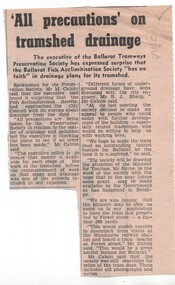
Newspaper, The Courier Ballarat, "All precautions on tram shed drainage", 14/11/1972 12:00:00 AM
... Ballarat Tramway Museum South Gardens Reserve Wendouree Parade Ballarat Ballarat goldfields Trams tramways BTPS Fish Hatchery Drainage date in pencil of "14/11/72" in top right hand corner of cutting. ...Newspaper clipping from The Courier, 14/11/1972 about Mr Maurie Calnin for the BTPS expressing surprise that the Fish Acclimatisation Society had approached the City Council with its worries about drainage from the shed. Notes discussion with Mr. Sharp, the City Engineer and the hope that it would be able to have the tram line saved to Forest St. to enable passengers to disembark at Wendouree Railway Station.date in pencil of "14/11/72" in top right hand corner of cutting.trams, tramways, btps, fish hatchery, drainage -
 Ballarat Tramway Museum
Photograph - Black & White Photograph/s, George Netherway, 15/05/1937 12:00:00 AM
... Gardens Reserve Wendouree Parade Ballarat Ballarat goldfields Trams Tramways Ballarat Lydiard St. Nth Extension New Track Tramways Copy photograph of a small photograph contained within item Reg. No. 587. Photo is of the construction of the Lydiard St. North extension in 1937. Caption from 587 is "South between Walker St. and Landsborough St - see drainage ...Copy photograph of a small photograph contained within item Reg. No. 587. Photo is of the construction of the Lydiard St. North extension in 1937. Caption from 587 is "South between Walker St. and Landsborough St - see drainage trench". Presumably taken at same time as 590. Hi Res scan added 25/3/2011trams, tramways, ballarat, lydiard st. nth extension, new track, tramways -
 Ballarat Tramway Museum
Administrative record - Memorandum, State Electricity Commission of Victoria (SECV), "Electrolysis", 26/01/1939 12:00:00 AM
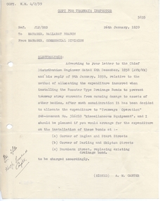
... Ballarat Tramway Museum South Gardens Reserve Wendouree Parade Ballarat Ballarat goldfields Yields information about the installation of electrolysis drainage bonds and the costing allocation - to the tramways, Yields information about the installation of electrolysis drainage bonds and the costing allocation - to the tramways Trams tramways Electrolysis Tramways Power Supply Has an ink notation in the bottom left hand corner. ...Yields information about the installation of electrolysis drainage bonds and the costing allocation - to the tramways, Yields information about the installation of electrolysis drainage bonds and the costing allocation - to the tramwaysTyped quarto sheet, dated 26/1/1939 copy of a memo for the Tramways Inspector prepared by the Manager Ballarat Division for the Manager, Commercial Division, regarding Electrolysis and the installation of Booster Type Drainage bonds and the allocation of the cost of this work. Signed by A. M. Carter.Has an ink notation in the bottom left hand corner.trams, tramways, electrolysis, tramways, power supply -
 Ballarat Tramway Museum
Document - Letter/s, State Electricity Commission of Victoria (SECV), 23/09/1965 12:00:00 AM
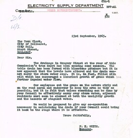
... Ballarat Tramway Museum South Gardens Reserve Wendouree Parade Ballarat Ballarat goldfields Yields information about the nature of correspondence between the SEC and the City re Council issues. Trams tramways City Of Ballarat Drainage ...Yields information about the nature of correspondence between the SEC and the City re Council issues.Copy of a letter on Electricity Supply Department letterhead, quarto paper typed, from Engineer and Manager (Melbourne) to City of Ballarat, dated 23-9-1965, with a copy to the "Works Superintendent", about the condition of the drainage in Gregory St, storm water not getting away - stagnant. Signed F, K White as Manager,trams, tramways, city of ballarat, drainage, depot -
 Heidelberg Golf Club
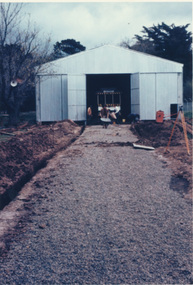
Photograph, Heidelberg Golf Club: Clubhouse renovations 1997-98 - Drainage work and garden, 1997
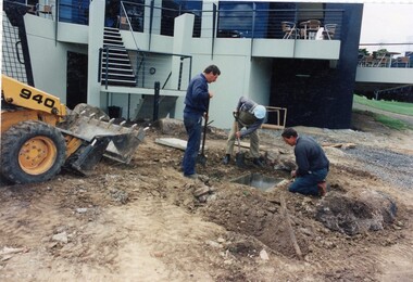
... Heidelberg Golf Club: Clubhouse renovations 1997-98 - Drainage work and garden ...Heidelberg Golf Club: Clubhouse renovations 1997-98 - Drainage work and garden at rear of clubhouse between Eaglemont Room and 4th fairway...Heidelberg Golf Club 8 Main Road Lower Plenty 3093 Heidelberg Golf Club: Clubhouse renovations 1997-98 - Drainage work and garden at rear of clubhouse between Eaglemont Room and 4th fairway Clubhouse redevelopment 1998 HGC Clubhouse 1997 Eaglemont Room 4th fairway Colour photographs x3 and caption, in album Heidelberg Golf Club: Clubhouse renovations 1997-98 - Drainage work and garden Photograph Photograph ...Heidelberg Golf Club: Clubhouse renovations 1997-98 - Drainage work and garden at rear of clubhouse between Eaglemont Room and 4th fairwayColour photographs x3 and caption, in albumclubhouse redevelopment 1998, hgc clubhouse 1997, eaglemont room, 4th fairway -
Marysville & District Historical Society
THE TRIANGLE NEWS-VOL 41 NO 18-MAY 16 2014
... drainage works...building our business community...cleaner needed for marysville villains...alexandra clearing sale...bleak day at emerald for villains...lake mountain...mountain mayhem...tenders...marysville preschool centre...long day care & kindergarten...el kanah marysville...eat in eat out menu...marsyville beer & platter garden...marysville victoria australia field naturalist club camp oeg's camp marsyville triangle news new contact details what's on when in may 2014 seasonal influenza vaccine available the committee of management of the gallipoli park precinct marysville community market creative triangle marysville triangle business & tourism first general members meeting portable skate ramp at buxton reserve church notices marysville golf report intrepid triangle bushwalkers buxton park first bootcamp mayor's chair by cr margaret rae councillor comment advertisements murrindindi shire council capital works program payment of rate instalment residential and rural real estate marysville triangle real estate depression recovery program buxton drainage works building our business community cleaner needed for marysville villains alexandra clearing sale bleak day at emerald for villains lake mountain mountain mayhem tenders marysville preschool centre long day care & kindergarten el kanah marysville eat in eat out menu marsyville beer & platter garden closed for winter black spur inn kitchen assistant wanted an invitation to join efforts emergence from surviving to thriving council continues to advocate for funding support buxton hall trivia night news from gallipoli park precinct lake mountain alpine resort opening weekend biggest morning tea cancer council THE TRIANGLE NEWS-VOL 41 NO 18-MAY 16 2014 ...marysville, victoria, australia, field naturalist club camp, oeg's camp marsyville, triangle news new contact details, what's on when in may, 2014 seasonal influenza vaccine available, the committee of management of the gallipoli park precinct, marysville community market, creative triangle, marysville triangle business & tourism first general members meeting, portable skate ramp at buxton reserve, church notices, marysville golf report, intrepid triangle bushwalkers, buxton park first bootcamp, mayor's chair by cr margaret rae, councillor comment, advertisements, murrindindi shire council capital works program, payment of rate instalment, residential and rural real estate, marysville triangle real estate, depression recovery program, buxton drainage works, building our business community, cleaner needed for marysville villains, alexandra clearing sale, bleak day at emerald for villains, lake mountain, mountain mayhem, tenders, marysville preschool centre, long day care & kindergarten, el kanah marysville, eat in eat out menu, marsyville beer & platter garden closed for winter, black spur inn kitchen assistant wanted, an invitation to join efforts, emergence from surviving to thriving, council continues to advocate for funding support, buxton hall trivia night, news from gallipoli park precinct, lake mountain alpine resort opening weekend, biggest morning tea, cancer council -
 Ballarat Tramway Museum
document - Circular, Ballarat Tramway Preservation Society (BTPS), "Volunteer Work Party Enquiry Sheet", c1979
... Ballarat Tramway Museum South Gardens Reserve Wendouree Parade Ballarat Ballarat goldfields Tram trams BTPS Trackwork Overhead Demi - foolscap duplicated sheet titled "Volunteer Work Party Enquiry Sheet", asking BTPS members to express interest in undertaking work for the Society in construction of trackwork, drainage and overhead. ...Demi - foolscap duplicated sheet titled "Volunteer Work Party Enquiry Sheet", asking BTPS members to express interest in undertaking work for the Society in construction of trackwork, drainage and overhead. Gives contact details and that Bungaree is available for accommodation - c1978. Headed Ballarat Tourist Tramway. Contact details for Len Doull, Bill Kingsley and Peter Winspur. Has space for a person to return to 30 Barcelona St with their details. Sent out at the same time as a Membership Renewal.tram, trams, btps, trackwork, overhead -
 Kew Historical Society Inc
Plan, Melbourne & Metropolitan Board of Works : Borough of Kew : Detail Plan No.1576, 1904
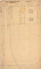
... drainage system. The plans, at a scale of 40 feet to 1 inch (1:480), provide a detailed historical record of Melbourne streetscapes and environmental features. Each plan covers one or two street blocks (roughly six streets), showing details of buildings, including garden layouts and ownership boundaries, and features such as laneways, drains, bridges, parks, municipal boundaries and other prominent landmarks as they existed at the time each plan was produced. ...drainage system. The plans, at a scale of 40 feet to 1 inch (1:480), provide a detailed historical record of Melbourne streetscapes and environmental features. Each plan covers one or two street blocks (roughly six streets), showing details of buildings, including garden layouts and ownership boundaries, and features such as laneways, drains, bridges, parks, municipal boundaries and other prominent landmarks as they existed at the time each plan was produced. ...The Melbourne and Metropolitan Board of Works (MMBW) plans were produced from the 1890s to the 1950s. They were crucial to the design and development of Melbourne's sewerage and drainage system. The plans, at a scale of 40 feet to 1 inch (1:480), provide a detailed historical record of Melbourne streetscapes and environmental features. Each plan covers one or two street blocks (roughly six streets), showing details of buildings, including garden layouts and ownership boundaries, and features such as laneways, drains, bridges, parks, municipal boundaries and other prominent landmarks as they existed at the time each plan was produced. (Source: State Library of Victoria)This plan forms part of a large group of MMBW plans and maps that was donated to the Society by the Mr Poulter, City Engineer of the City of Kew in 1989. Within this collection, thirty-five hand-coloured plans, backed with linen, are of statewide significance as they include annotations that provide details of construction materials used in buildings in the first decade of the 20th century as well as additional information about land ownership and usage. The copies in the Public Record Office Victoria and the State Library of Victoria are monochrome versions which do not denote building materials so that the maps in this collection are invaluable and unique tools for researchers and heritage consultants. A number of the plans are not held in the collection of the State Library of Victoria so they have the additional attribute of rarity.Original survey plan, issued by the MMBW to a contractor with responsibility for constructing sewers in the area identified on the plan within the Borough of Kew. The plan was at some stage hand-coloured, possibly by the contractor, but more likely by officers working in the Engineering Department of the Borough and later Town, then City of Kew. The hand-coloured sections of buildings on the plan were used to denote masonry or brick constructions (pink), weatherboard constructions (yellow), and public buildings (grey). Development in the 20th century has irreparably altered that part of Kew represented in this plan. In the block bounded by Cotham Road, Charles Street, Wellington Street and Gellibrand; just one house standing in 1903 remains. This block included two of the most historic houses in Kew: ‘Ordsall’ (later ‘Southesk’) and ‘Madford’ (previously ‘Elm Lodge’). Ordsall was the home of the second chairman of Kew, John Halfey. It contained some of the most significant interior murals in Kew, created for Halfey by artists working for Cullen & Co. It was demolished in 1960 to make way for the Kew Civic Centre. Elm Lodge had been built for William Siddeley in ca. 1864. Arthur Septimus King purchased it in 1874. The lower paddocks of Madford were sold in 1905 by his wife to the Borough of Kew and, after landscaping by George and Thomas Pockett, opened as the Alexandra Gardens in 1908. Elm Lodge/Madford was in 1922 to become St. Anthony’s Home for Little Children before its subsequent demolition in the 1980s.melbourne and metropolitan board of works, detail plans, maps - borough of kew, mmbw 1576, cartography -
 Kew Historical Society Inc
Plan, Borough of Kew Detail Plan No.1577, 1904
... drainage system. The plans, at a scale of 40 feet to 1 inch (1:480), provide a detailed historical record of Melbourne streetscapes and environmental features. Each plan covers one or two street blocks (roughly six streets), showing details of buildings, including garden layouts and ownership boundaries, and features such as laneways, drains, bridges, parks, municipal boundaries and other prominent landmarks as they existed at the time each plan was produced. ...drainage system. The plans, at a scale of 40 feet to 1 inch (1:480), provide a detailed historical record of Melbourne streetscapes and environmental features. Each plan covers one or two street blocks (roughly six streets), showing details of buildings, including garden layouts and ownership boundaries, and features such as laneways, drains, bridges, parks, municipal boundaries and other prominent landmarks as they existed at the time each plan was produced. ...The Melbourne and Metropolitan Board of Works (MMBW) plans were produced from the 1890s to the 1950s. They were crucial to the design and development of Melbourne's sewerage and drainage system. The plans, at a scale of 40 feet to 1 inch (1:480), provide a detailed historical record of Melbourne streetscapes and environmental features. Each plan covers one or two street blocks (roughly six streets), showing details of buildings, including garden layouts and ownership boundaries, and features such as laneways, drains, bridges, parks, municipal boundaries and other prominent landmarks as they existed at the time each plan was produced. (Source: State Library of Victoria)This plan forms part of a large group of MMBW plans and maps that was donated to the Society by the Mr Poulter, City Engineer of the City of Kew in 1989. Within this collection, thirty-five hand-coloured plans, backed with linen, are of statewide significance as they include annotations that provide details of construction materials used in buildings in the first decade of the 20th century as well as additional information about land ownership and usage. The copies in the Public Record Office Victoria and the State Library of Victoria are monochrome versions which do not denote building materials so that the maps in this collection are invaluable and unique tools for researchers and heritage consultants. A number of the plans are not held in the collection of the State Library of Victoria so they have the additional attribute of rarity.Original survey plan, issued by the MMBW to a contractor with responsibility for constructing sewers in the area identified on the plan within the Borough of Kew. The plan was at some stage hand-coloured, possibly by the contractor, but more likely by officers working in the Engineering Department of the Borough and later Town, then City of Kew. The hand-coloured sections of buildings on the plan were used to denote masonry or brick constructions (pink), weatherboard constructions (yellow), and public buildings (grey). MMBW Plan No.1577 includes some of the most significant houses in Kew: Herbert Henty’s ‘Roxeth’ (now part of Trinity Grammar), ‘Butleigh Wooton’, ‘Bokara’ and ‘Harrow’. It also includes the streets that have since changed their names. That part of College Parade linked to Glenferrie Road is now named College Place, College Parade now extends further north, and Charles Street did not yet reach Barkers Road. Roxeth is one of a number of Henty houses in Kew. Herbert Henty made his home here and was elected a member of Kew Municipal Council in 1864 and mayor in 1868-69. Walter Henry Serle, of Harrow served in the First World War. He was awarded the Military Medal ‘’For conspicuous bravery and devotion to duty. On 29th September near BELLICOURT he showed the greatest bravery and determination when his platoon was attacked by enemy bombing parties. It was due largely to his personal efforts that all the attacks were repulsed. Until wounded, his utter disregard of personal safety and boldness in dealing with the attacks were the means of saving the situation and were an inspiring example to his men.’melbourne and metropolitan board of works, detail plans, maps - borough of kew, mmbw 1577, cartography -
 Kew Historical Society Inc
Plan, Melbourne & Metropolitan Board of Works : Borough of Kew : Detail Plan No.1578, 1904
... drainage system. The plans, at a scale of 40 feet to 1 inch (1:480), provide a detailed historical record of Melbourne streetscapes and environmental features. Each plan covers one or two street blocks (roughly six streets), showing details of buildings, including garden layouts and ownership boundaries, and features such as laneways, drains, bridges, parks, municipal boundaries and other prominent landmarks as they existed at the time each plan was produced. ...drainage system. The plans, at a scale of 40 feet to 1 inch (1:480), provide a detailed historical record of Melbourne streetscapes and environmental features. Each plan covers one or two street blocks (roughly six streets), showing details of buildings, including garden layouts and ownership boundaries, and features such as laneways, drains, bridges, parks, municipal boundaries and other prominent landmarks as they existed at the time each plan was produced. ...The Melbourne and Metropolitan Board of Works (MMBW) plans were produced from the 1890s to the 1950s. They were crucial to the design and development of Melbourne's sewerage and drainage system. The plans, at a scale of 40 feet to 1 inch (1:480), provide a detailed historical record of Melbourne streetscapes and environmental features. Each plan covers one or two street blocks (roughly six streets), showing details of buildings, including garden layouts and ownership boundaries, and features such as laneways, drains, bridges, parks, municipal boundaries and other prominent landmarks as they existed at the time each plan was produced. (Source: State Library of Victoria). This plan forms part of a large group of MMBW plans and maps that was donated to the Society by the Mr Poulter, City Engineer of the City of Kew in 1989. Within this collection, thirty-five hand-coloured plans, backed with linen, are of statewide significance as they include annotations that provide details of construction materials used in buildings in the first decade of the 20th century as well as additional information about land ownership and usage. The copies in the Public Record Office Victoria and the State Library of Victoria are monochrome versions which do not denote building materials so that the maps in this collection are invaluable and unique tools for researchers and heritage consultants. A number of the plans are not held in the collection of the State Library of Victoria so they have the additional attribute of rarity.Original survey plan, issued by the MMBW to a contractor with responsibility for constructing sewers in the area identified on the plan within the Borough of Kew. The plan was at some stage hand-coloured, possibly by the contractor, but more likely by officers working in the Engineering Department of the Borough and later Town, then City of Kew. The hand-coloured sections of buildings on the plan were used to denote masonry or brick constructions (pink), weatherboard constructions (yellow), and public buildings (grey). MMBW Plan No.1578 is significant in that it defines the extent of two private schools: Xavier College and Kew High School (now part of Trinity Grammar) by 1904. In relation to the latter, the plan clarifies which buildings the High School operated from behind the mansion ‘Molina’. Established in 1902, Trinity Grammar was to later lease and subsequently buy Molina (now ‘Merritt House’) and ‘Elsinore’ (now ‘Roberts House’). Xavier College had been established in 1872. This 1904 plan delineates the West Wing and the Great Hall (built in 1890).melbourne and metropolitan board of works, detail plans, maps - borough of kew, mmbw 1578, cartography -
 Kew Historical Society Inc
Plan, Melbourne & Metropolitan Board of Works. Borough of Kew Detail Plan No.1579, 1904
... drainage system. The plans, at a scale of 40 feet to 1 inch (1:480), provide a detailed historical record of Melbourne streetscapes and environmental features. Each plan covers one or two street blocks (roughly six streets), showing details of buildings, including garden layouts and ownership boundaries, and features such as laneways, drains, bridges, parks, municipal boundaries and other prominent landmarks as they existed at the time each plan was produced. ...drainage system. The plans, at a scale of 40 feet to 1 inch (1:480), provide a detailed historical record of Melbourne streetscapes and environmental features. Each plan covers one or two street blocks (roughly six streets), showing details of buildings, including garden layouts and ownership boundaries, and features such as laneways, drains, bridges, parks, municipal boundaries and other prominent landmarks as they existed at the time each plan was produced. ...The Melbourne and Metropolitan Board of Works (MMBW) plans were produced from the 1890s to the 1950s. They were crucial to the design and development of Melbourne's sewerage and drainage system. The plans, at a scale of 40 feet to 1 inch (1:480), provide a detailed historical record of Melbourne streetscapes and environmental features. Each plan covers one or two street blocks (roughly six streets), showing details of buildings, including garden layouts and ownership boundaries, and features such as laneways, drains, bridges, parks, municipal boundaries and other prominent landmarks as they existed at the time each plan was produced. (Source: State Library of Victoria). This plan forms part of a large group of MMBW plans and maps that was donated to the Society by the Mr Poulter, City Engineer of the City of Kew in 1989. Within this collection, thirty-five hand-coloured plans, backed with linen, are of statewide significance as they include annotations that provide details of construction materials used in buildings in the first decade of the 20th century as well as additional information about land ownership and usage. The copies in the Public Record Office Victoria and the State Library of Victoria are monochrome versions which do not denote building materials so that the maps in this collection are invaluable and unique tools for researchers and heritage consultants. A number of the plans are not held in the collection of the State Library of Victoria so they have the additional attribute of rarity.Original survey plan, issued by the MMBW to a contractor with responsibility for constructing sewers in the area identified on the plan within the Borough of Kew. The plan was at some stage hand-coloured, possibly by the contractor, but more likely by officers working in the Engineering Department of the Borough and later Town, then City of Kew. The hand-coloured sections of buildings on the plan were used to denote masonry or brick constructions (pink), weatherboard constructions (yellow), and public buildings (grey). While MMBW Plan No.1579 does not include many buildings, those that it does show are significant to Kew’s history. These include the ‘Kew [Railway] Station’ in Denmark Street and the ‘Recreation Hall’ and rear courts off Wellington Street. The plan shows the outline of the Recreation Hall, constructed in 1880, at the rear of which is listed a bowling green, two tennis courts, a ‘skittle alley’ and a pavilion. When the Hall was first built, the Kew Cricket Club occupied an adjacent ground, however in 1885 this was acquired by the State Government as the future location of the Kew Railway Station. The Plan also shows a single oval at Xavier College. This oval was completed in 1883. One of the current ovals conforms to this oval’s original shape and position in the school grounds.melbourne and metropolitan board of works, detail plans, maps - borough of kew, mmbw 1579, cartography