Showing 13613 items matching "geo-map"
-
 Phillip Island and District Historical Society Inc.
Book, GEO Productions, Geo Australasia, 1994
... Geo Australasia...GEO Magazine featuring eleven pages of Hector Goodall and his marine mammals....GEO Productions...Geo Australasia Book GEO Productions ...GEO Magazine featuring eleven pages of Hector Goodall and his marine mammals.Stamped 'Phillip Island & District Historical Society'. Donor : Kevin Findlay 4.8.1999. Vol. 15, no. 1 (Feb./?Apr. 1993)-Vol. 23, no. 4 (Dec./?Feb. 2001/?2002)wildlife, conservation, australasia, periodicals, description, travel, southeast asia, hector goodall -
 Stawell Historical Society Inc
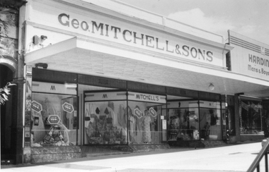
Photograph, Mr Geo. Mitchell & Sons shop in Main Street Stawell
... Mr Geo. Mitchell & Sons shop in Main Street Stawell....The black and white photograph of Geo. Mitchell & Sons shop with its three bay windows is in the Main St. ...Black and white photograph of Geo. Mitchell & Sons drapery shop with three display windows and parapet on top....Geo. Mitchell & Sons....The Mitchell family have strong associations from Stawell's early beginnings. stawell streetscape Geo. Mitchell & Sons. Black and white photograph of Geo. ...The black and white photograph of Geo. Mitchell & Sons shop with its three bay windows is in the Main St. Stawell. The family business closed in c 1987. The Mitchell family have strong associations from Stawell's early beginnings. Black and white photograph of Geo. Mitchell & Sons drapery shop with three display windows and parapet on top.Geo. Mitchell & Sons.stawell streetscape -
 National Wool Museum
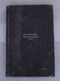
Book, Geo. Hague and Co. Wool Catalogues 1917-18
... Geo. Hague and Co. Wool Catalogues 1917-18..."Geo. Hague and Co. Wool Catalogues 1917-18". ...Geo. Hague and Co. Wool Catalogues 1917-18...GEO. HAGUE & CO. / WOOL CATALOGUES / 1917-18 / L.N.H....Geo. Hague and Co. Wool Catalogues 1917-18 Geo. ..."Geo. Hague and Co. Wool Catalogues 1917-18". Wool appraisement catalogues produced by the brokers George Hague and Co. and containing lists of wool for sale in 1917-18 in Geelong with types, bale brands, quantities, prices, clients etc. This catalogue was saved by Laurie Conolan (Museum Victoria) and came from the Elder's warehouse on Western Beach which was demolished during 1986.Geo. Hague and Co. Wool Catalogues 1917-18GEO. HAGUE & CO. / WOOL CATALOGUES / 1917-18 / L.N.H.wool brokering, wool bale descriptions, wool sales, george hague and co. pty ltd -
University of Melbourne, Burnley Campus Archives
Letter, Geo. W. Bell, Geo. W. Bell, 28.10.1980
... Geo. W. Bell...Handwritten letter to John Patrick from Geo. W. Bell dated 28.10.1980 about the lack of knowledge about the history of Burnley Gardens and various other criticisms. ...Geo. W. Bell...Description of attempts to acquire history of Burnley Gardens with some criticisms. john patrick geo w. bell geo w bell artist 1980 letter history of burnley gardens Handwritten letter to John Patrick from Geo. ...Author is an artist. Description of attempts to acquire history of Burnley Gardens with some criticisms.Handwritten letter to John Patrick from Geo. W. Bell dated 28.10.1980 about the lack of knowledge about the history of Burnley Gardens and various other criticisms. Archive entry includes photocopy also.john patrick, geo w. bell, geo w bell artist, 1980 letter, history of burnley gardens -
 Vision Australia
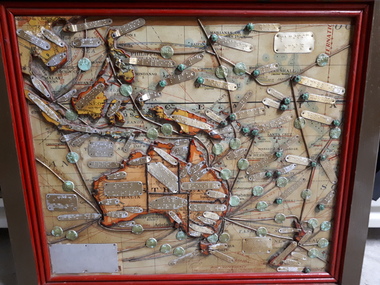
Map - Object, Map of Australia, Polynesia, Melanesia and Malaysia, 1939
... Map of Australia, Polynesia, Melanesia and Malaysia...Map...Tactile map of Australian states and territories, as well as various countries and islands in the South Pacific region, including Papua New Guinea, Indonesia and the Malay peninsula. ...1 paper map with tactile metal markers in red and brown frames...Queensland Braille Map & Model Club...Tunley 1 paper map with tactile metal markers in red and brown frames Map of Australia, Polynesia, Melanesia and Malaysia Map Object Queensland Braille Map & Model Club ...Tactile map of Australian states and territories, as well as various countries and islands in the South Pacific region, including Papua New Guinea, Indonesia and the Malay peninsula. 1 paper map with tactile metal markers in red and brown framesqueensland braille map and model club, r.f. tunley -
Tatura Irrigation & Wartime Camps Museum
Document, Reminiscences of Geo Campbell Camp 13 and Repatriation of German POW's Tuesday 21 January 1947 - Orantes, 27 October1986 Campbell, 6 January 1947 W.O. 2 Woof
... Reminiscences of Geo Campbell Camp 13 and Repatriation of German POW's Tuesday 21 January 1947 - Orantes...An account of Geo Campbell's stint as a guard compressed to 3 pages. ...Clear plastic cover, black margin on which is printed on a white paper strip "Reminiscences of Geo Campbell Camp 13 and Repatriation of German POW's Tuesday 21 January 1947 on H.T. ...Reminiscences of Geo Campbell Camp 13 and Repatriation of German POW's Tuesday 21 January 1947 - Orantes...Tatura Irrigation & Wartime Camps Museum 49 Hogan Street Tatura the-murray An account of Geo Campbell's stint as a guard compressed to 3 pages. ...An account of Geo Campbell's stint as a guard compressed to 3 pages. Also approved application overseas escort V1522 4 W.O. 2 Woof P. R.. Christmas cards and W.O. 2 Woof's diary commencing Tuesday 21 January 1947 of a reasonably placid trip on the H.T. Orantes. A 21 page diary and to conclude the contents, General Birdwood and Australians Anzac Day 1947 Trafalgar Square London and the service of commemoration at St Martins in the field Trafalgar Square.Clear plastic cover, black margin on which is printed on a white paper strip "Reminiscences of Geo Campbell Camp 13 and Repatriation of German POW's Tuesday 21 January 1947 on H.T. Orantes - Warrant Officer 2 P. R. Woof. Reminiscences of Geo Campbell Camp 13 and Repatriation of German POW's Tuesday 21 January 1947 - Orantesgeorge campbell, p. r. woof, h. t. orantes, repatriation -
 Vision Australia
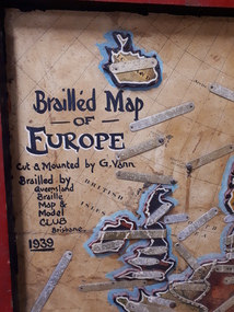
Map - Object, Brailled Map of Europe, 1939
... Brailled Map of Europe...Map...This tactile map of Europe was created in 1939, and brailled by the Queensland Braille Map and Model Club. ...Queensland Braille Map & Model Club...Vision Australia 454 Glenferrie Road Kooyong melbourne This tactile map of Europe was created in 1939, and brailled by the Queensland Braille Map and Model Club. ...This tactile map of Europe was created in 1939, and brailled by the Queensland Braille Map and Model Club. Cut and mounted by G. Vann with geographical inforamtion provided by Miss E Southern. The Queensland Braille Map and Model Club was a volunteer organisation which produced tactile maps from the 1920s to the late 1940s. These were sent as presents to schools, organisations and missions for people who were blind or vision impaired around Australia, New Zealand, Syria, India, Canada, Papua New Guinea and Africa. Due to free postage of Braille obtained by Tilly Aston and her compatriots, the maps were transported gratis within Australia and at a cheap rate overseas. When this map was made, East Prussia, Danzig and the Levant States were all separate countries. Some information about each country (name, area in sq miles and population) is written on a small door on the right hand side, which can be opened to reveal the same information in Braille. At the base is a braille and handwritten note "Information about maps gratis from Miss E Southern "Kingsley" George St, Brisbane. "For lending to the Blind" is written at the base of the wooden frame.1 paper attached to wooden mount with metal labels, on the right hand side a small door with country information on the front and opens to reveal the same in Braille. queensland braille map and model club, r.f. tunley -
Linton Mechanics Institute and Free Library Collection
Book - Novel, Fenn, Geo. Manville et al, First in the Field, A Story of New South Wales by Geo. Manville Fenn, [n.d.] [1894?]
... First in the Field, A Story of New South Wales by Geo. Manville Fenn...Fenn, Geo. Manville...First in the Field, A Story of New South Wales by Geo. Manville Fenn Book Novel Fenn, Geo. Manville Illustrated by W. ...Hardcover book, 416 pages : ill. Book has a black cover.fictiongeo. manville fenn, fiction, new south wales - historical fiction -
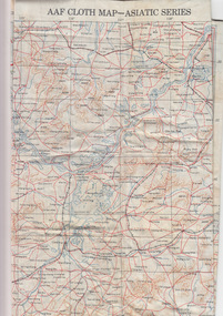 Geelong RSL Sub Branch
Silk Map - Asiatic Series, circa 1940s
... Silk Maps were produced by Great Britain and United States during WW2 some 3.5 million Silk Maps and cloth maps were produced for Allied Military Personnel....An oblong, cream colour silk map, Asiatic Series....AAF Cloth Map-Asiatic Series Side 1 - No 34 Southeast China Side 2 - No35 - Northeast China...Army Map Service US Army Washington DC...Geelong RSL Sub Branch 50 Barwon Heads Road Belmont geelong-and-the-bellarine-peninsula Silk Maps were produced by Great Britain and United States during WW2 some 3.5 million Silk Maps and cloth maps were produced for Allied Military Personnel. ...Silk Maps were produced by Great Britain and United States during WW2 some 3.5 million Silk Maps and cloth maps were produced for Allied Military Personnel.This Silk Map is an original map from the WW2 era.An oblong, cream colour silk map, Asiatic Series.AAF Cloth Map-Asiatic Series Side 1 - No 34 Southeast China Side 2 - No35 - Northeast Chinaww2, silk map, great britain, united states -
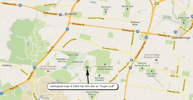 Greensborough Historical Society
Map, Overlay/comparison Map for 1868 Greensborough-Bundoora Geological Map area, 1868_
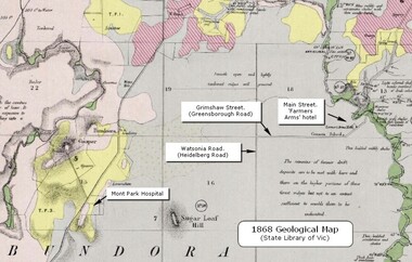
... Map...Overlay/comparison Map for 1868 Greensborough-Bundoora Geological Map area....This map is a comparison to the map at Item 2518, questioning the location of "Sugar Loaf". ...Map copied from Google maps....Annotation on map....Annotation by GHS member Ian Bryant. sugarloaf hill bundoora greensborough - maps Annotation on map. Map copied from Google maps. ...This map is a comparison to the map at Item 2518, questioning the location of "Sugar Loaf". Annotation by GHS member Ian Bryant.Map copied from Google maps.Annotation on map.sugarloaf hill, bundoora, greensborough - maps -
![Geo. Ramsay, Mayor [of Kew] 1925/6](/media/collectors/550653872162f11fb04854aa/items/5922bcacd0cde0131c89c68a/item-media/5c1c293221ea7918c01ddbda/item-fit-380x285.jpg?cb=6) Kew Historical Society Inc
Kew Historical Society IncPhotograph, Geo. Ramsay, Mayor [of Kew] 1925/6, 1925
... Geo. Ramsay, Mayor [of Kew] 1925/6...Framed portrait of Cr. Geo. Ramsay, Mayor of Kew 1925-26. The mounting and framing of the photograph follows a typical layout or style in that each is framed in dark wood, glazed, and laid down on an inscribed board. ...[Inscription] "Geo. Ramsay, Mayor 1925/6....) — municipal collection [Inscription] "Geo. Ramsay, Mayor 1925/6 Framed portrait of Cr. ...Kew achieved independence from the Boroondara Roads Board in 1860. As a new municipality, its first three leaders were designated as chairmen. On becoming a borough in 1863, its leaders were identified as mayors. The earliest photographs date from ca.1906, when the Town of Kew commissioned the noted local photographer Josiah E Barnes to produce standardised portraits of former mayors to be displayed in the Mayoral Chamber of the Town Hall. The collection also includes photographs by other well-known photographic studios such as Burlington Studios, Melba – Melbourne, Stuart Tompkins, Spencer Shier and Talma & Co. The majority of mounts identify the photographer. Eighty photographs are housed in their original frames.This portrait is one of a series of mounted and framed photographic portraits of mayors and town clerks of the former Borough, Town and City of Kew. The portraits were transferred by the City of Kew to the Kew Historical Society in March 1989. A Significance Assessment in 2018, funded by the National Library of Australia confirmed the historic, and often artistic significance of the series.Framed portrait of Cr. Geo. Ramsay, Mayor of Kew 1925-26. The mounting and framing of the photograph follows a typical layout or style in that each is framed in dark wood, glazed, and laid down on an inscribed board. The inscription identifies the name of the mayor and the year/s that he/she served.[Inscription] "Geo. Ramsay, Mayor 1925/6mayors of kew - cr. george ramsay - kew (vic), kew (vic.) — municipal collection -
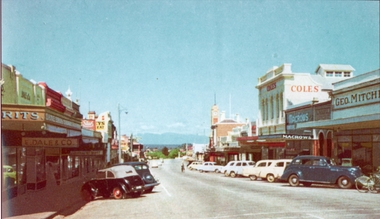 Stawell Historical Society Inc
Photograph, Main Street Stawell looking West with Geo. Mitchell shop on the right c 1955 -- Coloured
... Main Street Stawell looking West with Geo. Mitchell shop on the right c 1955 -- Coloured...Coloured photo c 1955 Main Street Scene looking West. Geo Mitchell Draper on right with Coles and Macrows. ...Coles, Macrows and Geo. Mitchell shops are on the right and E. ...Coles, Macrows and Geo. Mitchell shops are on the right and E. ...Coloured photo c 1955 Main Street Scene looking West. Geo Mitchell Draper on right with Coles and Macrows. On the left E. Dale & Co. shop sign is visible. Either side of the street has cars parked at an angle with a soft canopy car parked on the left side.Colour photograph looking down Main St Stawell with the Grampians in the distance c 1955. This coloured photo has shops either side in view and cars parked at an angle along the street. Coles, Macrows and Geo. Mitchell shops are on the right and E. Dale & Co shop sigh is visible on the left.stawell business streetscape -
 Dandenong/Cranbourne RSL Sub Branch
Document - Framed Information Sheet, About The Map, Circa 2000s
... About The Map....The map was produced over a period of 15 months and drawn in four stages. ...Framed information sheet of the map produced to show the various camps and sights along the Burma Thailand railway. ...The map was produced using a number of older railway maps, including the Escritt translated map and a local Thai road touring map....The map was produced using a number of older railway maps, including the Escritt translated map and a local Thai road touring map. ...The information sheet belongs with a map showing the Burma Thailand Railway and it's route with the various camps and P.O.W centres. The map was produced over a period of 15 months and drawn in four stages. Shows Hellfire Pass formerly ( The Konyu Cutting). The 50 Kilo Camp in Burma. There were 56 stations and 87 camps on the route of the map. The map gives due credibility and was released as a limited edition of 1000 copies only. Copies of the map are displayed all over the world including Staffordshire in England, University of Houston, National Guard Museum of Texas and on display at the Australian and New Zealand Embassies in Bangkok.Framed information sheet of the map produced to show the various camps and sights along the Burma Thailand railway. The map was produced using a number of older railway maps, including the Escritt translated map and a local Thai road touring map. -
 Bendigo Military Museum
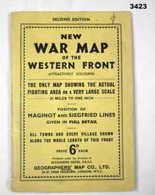
Map - WAR MAP WESTERN FRONT, Geographer's Map Co Ltd, c.WWII
... Map...Map...Folded map fixed into yellow cardboard folder with black printing. ...On cover in black print: “Second Edition. New War Map of the Western Front”...Geographer's Map Co Ltd...Map WAR MAP WESTERN FRONT. Geographer's Map Co Ltd ...Folded map fixed into yellow cardboard folder with black printing. Map covers battle areas late in WWII of Maginot Line & Siegfried Line from Metz, France to Karlsruhe, Germany.On cover in black print: “Second Edition. New War Map of the Western Front”map, seigfreid, maginot -
 Greensborough Historical Society
Map - Geological Map, 1868 Geological map of Greensborough (annotated), 1868_
... 1868 Geological map of Greensborough (annotated)...Map...This geological map from the State Library of Victoria collection has been annotated by GHS member Ian Bryant to show some local landmarks...Digital copy of colour map....Annotations on map show locations....Digital copy of colour map. 1868 Geological map of Greensborough (annotated) Map Geological Map Ian Bryant ...This geological map from the State Library of Victoria collection has been annotated by GHS member Ian Bryant to show some local landmarksDigital copy of colour map.Annotations on map show locations.greensborough - maps, 1860s melbourne, suburbs, geography, roads -
 Bendigo Military Museum
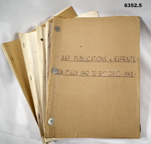
Administrative record - LHQ Cartographic Coy - Map Printing and Reprints 1 July 1942- 31 Dec 1947, LHQ Cartographic Coy, 1942-1947
... LHQ Cartographic Coy - Map Printing and Reprints 1 July 1942- 31 Dec 1947...These records detail which maps were printed during those years. Photographs of the printing machines and the printers who used them are shown in Victorian Collections item 6148 LHQ Carto Coy Souvenir Booklet. 6352.1 Map Publishing and Reprinting Reports 1 July 1942 - 31 Dec 1943 6352.2 Map Publishing and Reprinting Reports 1 July 1943 - 31 Dec 1944 6352.3 Map Publishing and Reprinting Reports 1 July 1944 - 31 Dec 1945 6352.4 Map Publishing and Reprinting Reports 1 July 1945 - 31 Dec 1946 6352.5 Map Publishing and Reprinting Reports 1 July 1946 - 31 Dec 1947...Five Manilla Folders containing Map Printing Reports...Hand written on the Folder covers: 6352.1 Map Publishing and Reprinting Reports 1 July 1942 - 31 Dec 1943 6352.2 Map Publishing and Reprinting Reports 1 July 1943 - 31 Dec 1944 6352.3 Map Publishing and Reprinting Reports 1 July 1944 - 31 Dec 1945 6352.4 Map Publishing and Reprinting Reports 1 July 1945 - 31 Dec 1946 6352.5 Map Publishing and Reprinting Reports 1 July 1946 - 31 Dec 1947...These records detail which maps were printed during those years. Photographs of the printing machines and the printers who used them are shown in Victorian Collections item 6148 LHQ Carto Coy Souvenir Booklet. 6352.1 Map Publishing and Reprinting Reports 1 July 1942 - 31 Dec 1943 6352.2 Map Publishing and Reprinting Reports 1 July 1943 - 31 Dec 1944 6352.3 Map Publishing and Reprinting Reports 1 July 1944 - 31 Dec 1945 6352.4 Map Publishing and Reprinting Reports 1 July 1945 - 31 Dec 1946 6352.5 Map Publishing and Reprinting Reports 1 July 1946 - 31 Dec 1947 Royal Australian Survey Corps RASvy Fortuna Army Survey Regiment Army Svy Regt ASR Hand written on the Folder covers: 6352.1 Map Publishing and Reprinting Reports 1 July 1942 - 31 Dec 1943 6352.2 Map Publishing and Reprinting Reports 1 July 1943 - 31 Dec 1944 6352.3 Map Publishing and Reprinting Reports 1 July 1944 - 31 Dec 1945 6352.4 Map Publishing and Reprinting Reports 1 July 1945 - 31 Dec 1946 6352.5 Map Publishing and Reprinting Reports 1 July 1946 - 31 Dec 1947 Five Manilla Folders containing Map Printing Reports LHQ Cartographic Coy - Map Printing and Reprints 1 July 1942- 31 Dec 1947 Administrative record LHQ Cartographic Coy - Map Printing and Reprints 1 July 1942- 31 Dec 1947 LHQ Cartographic Coy ...The Land Headquarters Cartographic Company relocated to Fortuna Villa, Bendigo in 1942. With printing presses acquired from a number of civilian organizations it printed the maps needed for the Australian WW11 war effort. These records detail which maps were printed during those years. Photographs of the printing machines and the printers who used them are shown in Victorian Collections item 6148 LHQ Carto Coy Souvenir Booklet. 6352.1 Map Publishing and Reprinting Reports 1 July 1942 - 31 Dec 1943 6352.2 Map Publishing and Reprinting Reports 1 July 1943 - 31 Dec 1944 6352.3 Map Publishing and Reprinting Reports 1 July 1944 - 31 Dec 1945 6352.4 Map Publishing and Reprinting Reports 1 July 1945 - 31 Dec 1946 6352.5 Map Publishing and Reprinting Reports 1 July 1946 - 31 Dec 1947Five Manilla Folders containing Map Printing ReportsHand written on the Folder covers: 6352.1 Map Publishing and Reprinting Reports 1 July 1942 - 31 Dec 1943 6352.2 Map Publishing and Reprinting Reports 1 July 1943 - 31 Dec 1944 6352.3 Map Publishing and Reprinting Reports 1 July 1944 - 31 Dec 1945 6352.4 Map Publishing and Reprinting Reports 1 July 1945 - 31 Dec 1946 6352.5 Map Publishing and Reprinting Reports 1 July 1946 - 31 Dec 1947royal australian survey corps, rasvy, fortuna, army survey regiment, army svy regt, asr -
 Federation University Historical Collection
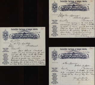
Document, Correspondence from Geo Barker to School of Mines Ballarat
... Correspondence from Geo Barker to School of Mines Ballarat...3 pages of handwritten correspondence from Geo Barker to School of Mines Ballarat ...Barker Library (top floor) Mount Helen goldfields School of Mines is a predecessor of Federation University Geo Barker Invincible Carriage and Wagon Works School of Mines Ballarat 3 pages of handwritten correspondence from Geo Barker to School of Mines Ballarat Correspondence from Geo Barker to School of Mines Ballarat Document ...School of Mines is a predecessor of Federation University 3 pages of handwritten correspondence from Geo Barker to School of Mines Ballarat geo barker, invincible carriage and wagon works, school of mines ballarat -
 Federation University Historical Collection
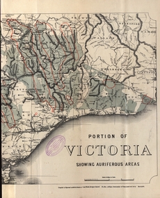
Map - Map and Information, Department of Mines: Map and Suggestions to Prospectors, 1891
... Department of Mines: Map and Suggestions to Prospectors...Map...The map outlines the auriferous (gold bearing) areas in Victoria. ...Document: 4 page type written Map: Portion of Victoria divided into Counties of 1891. ...Reference section on map...Department of Mines: Map and Suggestions to Prospectors Map Map and Information Robert S Bain Alexander Black Hon. ...The map outlines the auriferous (gold bearing) areas in Victoria. The information for prospectors was prepared by the Department of Mines in 1894Document: 4 page type written Map: Portion of Victoria divided into Counties of 1891. Auriferous areas with red.Reference section on mapgold, auriferous areas, department of mines, victoria, map of victoria, prospectors, commissioner of crown lands, hon a mclean, alexander black, surveyor general, a mclean -
 Anglesea and District Historical Society
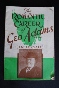
Pamphlet, "T" & "S" Print, The Romantic Career of Geo Adams (Tattersall), 1939
... The Romantic Career of Geo Adams (Tattersall)...The Romantic Career of Geo Adams. Hobart. (TATTERSALL)....Anglesea and District Historical Society 5B McMillan Street Anglesea great-ocean-road geo adams tattersall The Romantic Career of Geo Adams. ...Small booklet on the career of George Adams, founder of Tattersall's. With honesty and integrity as his watchwords he built his business on firm foundations. George Adams died 21 Sept., 1904 but left his character in the business.The Romantic Career of Geo Adams. Hobart. (TATTERSALL).geo adams, tattersall -
 Whitehorse Historical Society Inc.
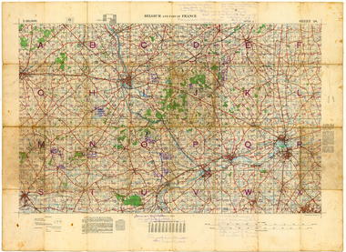
Map - Belgium and part of France map WW1, Belgium and part of France map WW1with penciled annotations by Charles H. Honybun, Nov 1917
... Belgium and part of France map WW1with penciled annotations by Charles H. ...Map...WW1 map of Belgium and part of France used by Allied Troops...Map bounded by Balleul, Poperinghe, Ypres, Menin, Moorsele, Tourooing...Penciled inscriptions on map and the borders added by Charles H. Honybun on ND8206a...Whitehorse Historical Society Inc. 2-10 Deep Creek Road Mitcham melbourne WW1 map of Belgium and part of France used by Allied Troops World War 1914 - 1918 World War 1914 - 1918 Battle of Ypres Maps WW1 map of Ypres and Menin. ...WW1 map of Ypres and Menin. Sheet 28 Edition 3 Scale 1: 40,000 Nov 1917Map bounded by Balleul, Poperinghe, Ypres, Menin, Moorsele, Tourooingnon-fictionWW1 map of Ypres and Menin. Sheet 28 Edition 3 Scale 1: 40,000 Nov 1917world war 1914 - 1918, world war 1914 - 1918 battle of ypres, maps -
 University of Melbourne, Burnley Campus Archives
Photograph - Black and white print, Geo. Russ. Foreman & Propagator, 1922-1923
... Geo. Russ. Foreman & Propagator...On reverse, "Geo. Russ. Foreman & Propagator. 1922 or '23."...University of Melbourne, Burnley Campus Archives 500 Yarra Boulevard Richmond melbourne geo. russ foreman propagator old nursery On reverse, "Geo. ...Black and white photograph. George Russ standing in the Old Nursery. Another copy B91.285.On reverse, "Geo. Russ. Foreman & Propagator. 1922 or '23."geo. russ, foreman, propagator, old nursery -
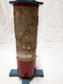 Vision Australia
Map - Object, R.F. Tunley, Braille cylinder map, 1940-1950s
... Braille cylinder map...Map...This map was produced by Richard Francis Tunley and given to the Victorian Braille Library for use by it's patrons. ...1 metal cylindrical map with tactile markers...Commercial & Strategic Map of the British Empire Presented to the Victorian Braille Library...Tunley Commercial & Strategic Map of the British Empire Presented to the Victorian Braille Library 1 metal cylindrical map with tactile markers Braille cylinder map Map Object R.F. ...This map was produced by Richard Francis Tunley and given to the Victorian Braille Library for use by it's patrons. Mr Tunley was a prolific Braille map maker as well as producing other items for blind and vision impaired children, advocated for compulsory education for blind and deaf children and established the Queensland Braille Map and Model Club. Leading by example, his maps were treasured by those who used them and were an outstanding piece of craftsmanship. In this example, the metal cylinder sits on a wooden base and can be turned via a handle in the wooden top or rotating the sides. A brailled red metal plate occupies the bottom third, and large continents have a metal plate, cut to shape, upon which braille country/continent names are placed. Major rivers are traced through raised lines in the metal continental plates, twisted wire traces shipping routes with associated brailled metal plates, raised metal pins in some major locations and more explanatory plates sit in various oceans.1 metal cylindrical map with tactile markersCommercial & Strategic Map of the British Empire Presented to the Victorian Braille Librarybraille library of victoria, r.f. tunley -
 Vision Australia
Photograph - Image, Using a 3D map of Sydney
... Using a 3D map of Sydney...A blind man feels model buildings on a relief map of the Sydney CBD whilst two others look on. ...B/W photograph of blind man using relief map...Learning layout of City of Sydney by raised map Orientation - historical RBS XI...Royal Blind Society of NSW Maps Learning layout of City of Sydney by raised map Orientation - historical RBS XI B/W photograph of blind man using relief map Using a 3D map of Sydney Photograph Image ...A blind man feels model buildings on a relief map of the Sydney CBD whilst two others look on. B/W photograph of blind man using relief mapLearning layout of City of Sydney by raised map Orientation - historical RBS XIroyal blind society of nsw, maps -
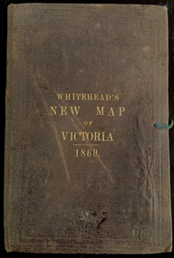 Kew Historical Society Inc
Map, Whitehead's Map of Victoria, With Alphabetical Key, 1869, 1869
... Map...Whitehead's Map of Victoria, With Alphabetical Key, 1869...Map...When E. Whitehead's New Map of Victoria was released in 1869, an advertisement in the Bendigo Advertiser (16 July 1869) noted that: "This beautifully engraved Map has been revised and brought down to the present time; and, with the Alphabetical Key, is the most complete and the cheapest Map ever published; Price, 6d plain; 1s colored; 2s 6d in case; on linen, post free, 2d extra. ...Map of Victoria with gold mining areas, notes on topography, transport routes. ...Cover "WHITEHEAD'S NEW MAP OF VICTORIA 1869"...Whitehead's Map of Victoria, With Alphabetical Key, 1869 Map Map E Whitehead & Co. ...When E. Whitehead's New Map of Victoria was released in 1869, an advertisement in the Bendigo Advertiser (16 July 1869) noted that: "This beautifully engraved Map has been revised and brought down to the present time; and, with the Alphabetical Key, is the most complete and the cheapest Map ever published; Price, 6d plain; 1s colored; 2s 6d in case; on linen, post free, 2d extra. E.. WHITEHEAD and CO, Publishers, 67 Collins-street east." The following year, 1870, Whitehead's promoted the edition in the Portland Guardian and Normanby General Advertiser (3 January 1870), advising that: "WHITEHEAD'S NEW MAP OF VICTORIA, 1869 ... is corrected to the latest date, and around is arranged an Alphabetical Key, with Post Towns and Money Order Olffices marked. The Map being divided into squares and numbered, by reference to the Key any place can be found immediately. Price Is beautifully colored, or mounted on linen in case, 2s 6d. Post free, 2d extra, in Victoria. B. Whitehead and C0., Puolishers, 67 Collins-street East, Melbourne". In the same edition of the Portland Advertiser, they also promoted their business generally, saying: "E WHITEHEAD and Co., Stationers, Engravers, Lithographers, 67 Collins street East, execute every description of Lithographic PRINTING, BILL-HEADS. NOTE Headings. Business Dies Engraved and Embossed on Envelopes &c. ARMS, MONOGRAMS, AND CRESTS Engraved and Embossed in Colour, superior to any other house in the Colony. Specimens, post free, 2d. Lithographers, &c, to H.R.H. the Duke of Edinburgh, and Die-inkers and Embossers to His Excellency Sir J. H. T. Manners-Sutton, K C.B. Orders executed for the Trade". Whitehead’s New Map of Victoria 1869 is is an important record of region created towards the end of the Victorian Gold Rush (1851-1869). In addition to its historical significance, this is a rare map, of which the only known copies in Australian public collections are those held at the National Library of Australia, the State Library of Victoria, State Library of New South Wales and the University of Queensland Library.Map of Victoria with gold mining areas, notes on topography, transport routes. Relief shown by hachures. List of towns with distance from Melbourne in map margin. [Melbourne] : Printed & Published by ... E Whitehead & Co ... 67 Collins Street East, 1869 1 map : col., mounted on linen ; 38.4 x 55.4 cm, folded to 18 x 12 cm.Cover "WHITEHEAD'S NEW MAP OF VICTORIA 1869"maps - victoria - 1860s, e whitehead's new map of victoria 1869, whitehead's map of victoria with alphabetical key 1869, cartography, gold rush -
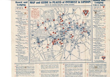 Lara RSL Sub Branch
Map, Map of London
... Map...Map of London...Map of London including Places of interest and Accommodation for Australian Navy, and Australian Imperial Force...Map of London - YMCA - Place of Interest and Accommodation for Soldiers and Sailors in London 1917...Map of London Rising Sun Badge Places of interest Accommodation for sailors and soldiers in London...Lara RSL Sub Branch McClelland Ave Lara Map of London including Places of interest and Accommodation for Australian Navy, and Australian Imperial Force Map given to Australian Navy and Imperial forces in London during WW1 map london ymca ww1 Map of London Rising Sun Badge Places of interest Accommodation for sailors and soldiers in London Map of London - YMCA - Place of Interest and Accommodation for Soldiers and Sailors in London 1917 Map of London Map ...Map of London including Places of interest and Accommodation for Australian Navy, and Australian Imperial ForceMap given to Australian Navy and Imperial forces in London during WW1Map of London - YMCA - Place of Interest and Accommodation for Soldiers and Sailors in London 1917Map of London Rising Sun Badge Places of interest Accommodation for sailors and soldiers in Londonmap london ymca ww1 -
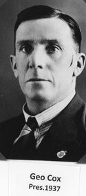 Stawell Historical Society Inc
Photograph, Stawell Athletic Club President Mr Geo Cox 1937
... Stawell Athletic Club President Mr Geo Cox 1937...Stawell Athletic Club President Geo Cox 1937...Stawell Historical Society Inc 46 Longfield St Stawell grampians Stawell Athletic Club President Geo Cox 1937 Stawell Sport Stawell Athletic Club President Mr Geo Cox 1937 Photograph ...Stawell Athletic Club President Geo Cox 1937stawell sport -
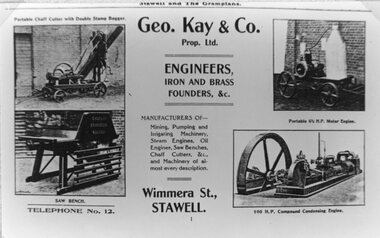 Stawell Historical Society Inc
Newspaper, Geo Kay & Co Foundry in Wimmera Street -- Newspaper Advertisement
... Geo Kay & Co Foundry in Wimmera Street -- Newspaper Advertisement ...Advertisement in Newspaper for Geo Kay & Co Foundry Wimmera Street...Advertisement in Newspaper for Geo Kay & Co Foundry Wimmera Street Stawell Businesses Geo Kay & Co Foundry in Wimmera Street -- Newspaper Advertisement Newspaper ...Advertisement in Newspaper for Geo Kay & Co Foundry Wimmera Streetstawell businesses -
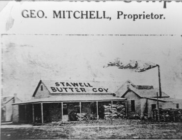 Stawell Historical Society Inc
Photograph, Stawell Butter Company Factory with Mr Geo. Mitchell as the Proprietor c1920's
... Stawell Butter Company Factory with Mr Geo. Mitchell as the Proprietor c1920's...Stawell Butter Company Factory. Early 1920s. Geo. Mitchell Proprietor....Stawell Historical Society Inc 46 Longfield St Stawell grampians Stawell Butter Company Factory. Early 1920s. Geo. Mitchell Proprietor. Stawell Stawell Butter Company Factory with Mr Geo. ...Stawell Butter Company Factory. Early 1920s. Geo. Mitchell Proprietor.stawell -
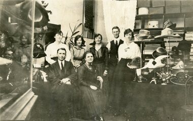 Stawell Historical Society Inc
Photograph, Mr Geo. Smith & Co's Drapery Store with Staff in Main Street Stawell
... Mr Geo. Smith & Co's Drapery Store with Staff in Main Street Stawell...Business Geo. Smith & Co Staff Clothiers and Hatters Main Street Stawell....Stawell Mr Geo. Smith & Co's Drapery Store with Staff in Main Street Stawell Photograph ...Business Geo. Smith & Co Staff Clothiers and Hatters Main Street Stawell.stawell -
 Lara RSL Sub Branch
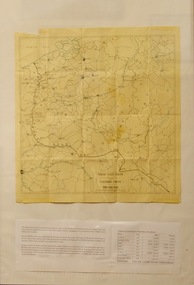
Map, Framed Map of the western front 1914-1918, Map made by G.F.Trudgion R.A.E. circa 1916
... Map...Framed Map of the western front 1914-1918...map...Map...Map showing position of western front line in 1914 at the start of WW1...Map of the western front 1914-1918...Map made by G.F.Trudgion R.A.E. circa 1916...Below is description of Australian ANZAC's on Western Front and a graph on Comparison of Casualties from Major Western Front Battles Map of the western front 1914-1918 Framed Map of the western front 1914-1918 Map Map ...Map showing position of western front line in 1914 at the start of WW1Map is from circa 1916 showing battle area of the Western Front during WW1Map of the western front 1914-1918North West Europe Shewing the Western Front 1914-1918 War. Below is description of Australian ANZAC's on Western Front and a graph on Comparison of Casualties from Major Western Front Battlesmap, g.f.trudgion, r.a.e., western front, ww1, world war one, north west europe, 1914, 1916, ww1 casulaties