Showing 304 items matching "geological library"
-
 Federation University Historical Collection
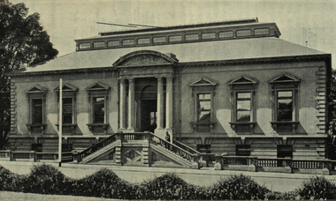
Photograph - black and white, Mines Department Geological Museum and Library, Melbourne
... Mines Department Geological Museum and Library, Melbourne......geological library...Barker Library (top floor) Mount Helen goldfields Photograph included in book "Victoria: Gold and Minerals" issued by Mines Department Victoria, 1935 victoria mines department melbourne geological museum geological library Photograph Mines Department Geological Museum and Library, Melbourne Photograph - black and white ...Photograph included in book "Victoria: Gold and Minerals" issued by Mines Department Victoria, 1935Photographvictoria, mines department, melbourne, geological museum, geological library -
 Kiewa Valley Historical Society
Report - Alpine Study Area Volume 2 Maps, Land Conservation Council, 1970s
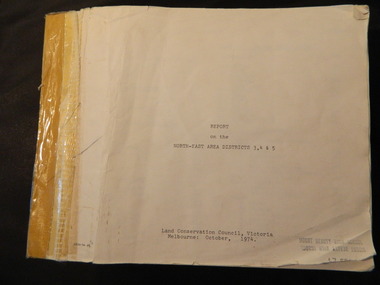
... Stamped in red "Discarded From Stock / Swan Hill Regional Library Blue box shaped folder containing 9 of 10 Maps of the Alpine Study Area produced by the Land Conservation Council. Maps include 1. Public land and descriptive blocks. 2. Physiography. 3. Topography. 4. Geology ...The Victorian Environmental Assessment Council and the former Environment Conservation Council (ECC) and Land Conservation Council (LCC) have completed 36 land use investigations over more than 35 years, including 27 regional reviews. They provide a framework for use of Public Land in Victoria. The Land Conservation Council was established by the Land Conservation Act 1970.These maps provide an assessment of the Alpine area at the time the maps were created. Some of the topics eg. Rainfall and water resources may change over the years thus providing a comparative analysis. Others may provide information for future development such as mineral exploration, building of a dam / tunnel etc.Blue box shaped folder containing 9 of 10 Maps of the Alpine Study Area produced by the Land Conservation Council. Maps include 1. Public land and descriptive blocks. 2. Physiography. 3. Topography. 4. Geology (missing). 5. Rainfall and water resources. 6. Vegetation 7. Land systems. 8. Recreation. 9. Primary production. 10. Minerals Ex library item. Stamped in red "Discarded From Stock / Swan Hill Regional Libraryalpine area, maps of alpine area, land conservation council -
 Kiewa Valley Historical Society
Report - Land Conservation Council x2, Land Conservation Council, Victoria Melbourne, April 1978, October 1974
... Geology, Topography, Land Systems, Outdoor Recreation, Public land and blocks. Primary Production. Vegetation. North East Victoria includes the Kiewa Valley. This report gives an understanding of the development of the area. land conservation council environment public land kiewa valley planning Stamped on Front Cover: "Mount Beauty High School" Has a library borrowing slip at the back of the last page. ...Land Conservation Act 1970 established the Land Conservation Council to investigate and recommend to the Minister use of public land in Victoria. It describes and assesses the natural resources:-Physiography, Geology, Topography, Land Systems, Outdoor Recreation, Public land and blocks. Primary Production. Vegetation.North East Victoria includes the Kiewa Valley. This report gives an understanding of the development of the area.Thick heavy book with 312 pages with black and white photos. Back half has a folder with heavy cardboard attached to thick cardboard back cover. Inside folder are 9 maps with color each with a different title.Stamped on Front Cover: "Mount Beauty High School" Has a library borrowing slip at the back of the last page.land conservation council, environment, public land, kiewa valley, planning -
 Kiewa Valley Historical Society
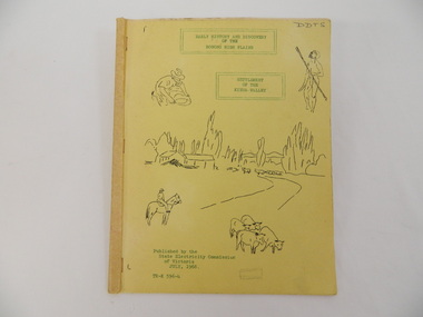
Book - Bogong High Plains x2, Early History and Discovery of the Bogong High Plains, 1968
... Library, the Victorian Historical Society, the North Eastern Victorian Historical Society and the Dept. of Crown Lands & Survey, Melbourne. The book is an accurate history of the Bogong High Plains given the available records at the time. bogong high plains. state electricity commission of victoria. kiewa. aborigines. kiewa valley. mullindollingong pastoral run. flora. geology DDTS hand written on front cover "Early History and Discovery / of the / Bogong High Plains" on cover top centre. ...The State Electricity Commission of Victoria constructed the Kiewa Hydro Electric Scheme in the north east of Victoria. Mr R.M. Duncan prepared the notes. He was a member of the S.E.C. Kiewa Branch from 1949 - 1966. This book was commissioned by the State Electricity Commission of Victoria. It consists of the early history of the Bogong High Plains and the origin of names of places and creeks in the area.This book was researched in 1968 by Mr R.M. Duncan who worked for the S.E.C. on the Kiewa Hydro Electric Scheme from 1949 to 1966. His sources were the Melbourne Public Library, the Victorian Historical Society, the North Eastern Victorian Historical Society and the Dept. of Crown Lands & Survey, Melbourne. The book is an accurate history of the Bogong High Plains given the available records at the time. Yellow cardboard covered book with black sketches and green print. 9 one-sided pages held together by 3 staples and taped over the staples. One - has sheets enclosed "The Three Floras of Bogong" and "General Geology of the Kiewa Area". 6 copies including 1 that is a photocopyDDTS hand written on front cover "Early History and Discovery / of the / Bogong High Plains" on cover top centre. "Settlement / of the / Kiewa-Valley" on cover towards the top slightly to the right. "Published by the / State Electricity Commission / of Victoria / July, 1968" on cover bottom left. "TR-K 596-4" on cover bottom left.bogong high plains. state electricity commission of victoria. kiewa. aborigines. kiewa valley. mullindollingong pastoral run. flora. geology -
 Federation University Historical Collection
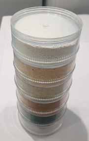
Geological specimen, Five Different Coloured sands
... Barker Library (top floor) Mount Helen goldfields sand geology ^ plastic cylindrical containers housing five different samples of sand Five Different Coloured sands Geological specimen ...^ plastic cylindrical containers housing five different samples of sandsand, geology -
 Federation University Historical Collection
Geological specimen, Rock
... Barker Library (top floor) Mount Helen goldfields Rock Geological specimen ... -
 Federation University Historical Collection
Book - Course Guide, University of Ballarat Program Guide 2012/13, 2012
... Library (top floor) Mount Helen goldfields The University of Ballarat was renamed Federation University Australia in 2014. Applications. Deferring. VTAC fees financial assistance scholarships TAFE Campuses Exchange Universities Stawell Campus Camp Street Campus Arts Academy SMB Campus Mt Helen Campus Ararat Campus Horsham Campus UB Tec Student Experience office Student Living Skills Aboriginal Education Centre Student Learning Skills Conselling UB PASS UB Ready SMB Fitness Centre Disability Helat Services Alumni Gold Key Chapter Student Res idences apprenticeships traineeships unisports ceramics acting teaching nursing human movement Nick Driden engineering geology mining equine Courses handbook Couloured cover, predominantly in ochre, with a young man's face featuring. ...Couloured cover, predominantly in ochre, with a young man's face featuring. Contents include: Applications. Deferring. VTAC, fees, financial assistance, scholarships, TAFE, Campuses, Exchange Universities, Stawell Campus, Camp Street Campus, Arts Academy, SMB Campus, Mt Helen Campus, Ararat Campus, Horsham Campus, UB Tec, Student Experience office, Student Living Skills, Aboriginal Education Centre, Student Learning Skills, Conselling, UB PASS, UB Ready, SMB Fitness Centre, Disability, Helat Services, Alumni, Gold Key Chapter, Student Res, idences, apprenticeships, traineeships, unisports, ceramics, acting, teaching, nursing, human movement, Nick Driden, engineering, geology, mining, equineapplications. deferring. vtac, fees, financial assistance, scholarships, tafe, campuses, exchange universities, stawell campus, camp street campus, arts academy, smb campus, mt helen campus, ararat campus, horsham campus, ub tec, student experience office, student living skills, aboriginal education centre, student learning skills, conselling, ub pass, ub ready, smb fitness centre, disability, helat services, alumni, gold key chapter, student res, idences, apprenticeships, traineeships, unisports, ceramics, acting, teaching, nursing, human movement, nick driden, engineering, geology, mining, equine, courses, handbook -
Federation University Historical Collection
Photograph, Geology Photograph
... Barker Library (top floor) Mount Helen goldfields Mt Helen Campus - predecessor of Federation University Geology Microscopes Students Photograph Colour Photograph Large photogrpah of students in the Geology course using microscopes Geology Photograph Photograph ...Mt Helen Campus - predecessor of Federation UniversityLarge photogrpah of students in the Geology course using microscopesgeology, microscopes, students, photograph, colour photograph -
Federation University Historical Collection
Geological specimen, Petrified
... Barker Library (top floor) Mount Helen goldfields petrified wood rock geology 14 specimens of petrified wood. ...14 specimens of petrified wood. Some smooth some rough.petrified wood, rock, geology -
Federation University Historical Collection
Geological specimen, Jaspar
... Barker Library (top floor) Mount Helen goldfields jaspar geology Six pieces of Jaspar (or jaspar like) rocks. ...Six pieces of Jaspar (or jaspar like) rocks.jaspar, geology -
 Federation University Historical Collection
Photograph, Ballarat School of Mines Associates Board 1951-1957, c1984
... Barker Library (top floor) Mount Helen goldfields In the early 1880s the Ballarat School of Mines Council introduced a three year course of training under the professors to qualify students in the following professions: 1. Mining Engineering 2. Metallurgy 3. Geology ...In the early 1880s the Ballarat School of Mines Council introduced a three year course of training under the professors to qualify students in the following professions: 1. Mining Engineering 2. Metallurgy 3. Geology 4. Electricity [45] Each of these courses had an additional, but optional, fourth year of study. The prescribed subjects of study for an Associateship was set out in the Calendar of the Ballarat School of Mines in each year. Any student who passed the prescribed examinations in any of the above courses was issued with a Certificate of Competency, and conferred with the distinction of Associate. By the 1890s the professorial staff had drawn up a curriculum leading to an Associateship of the Ballarat School of Mines. The first two years work was to be common to all courses, but in the third and subsequent years the student wold be devoted to a specialised branch of study. The Associateship was to be conferred in one of another of the following Courses: Agriculture, Civil Engineering, Electrical Engineering, [Geology], Metallurgy and Mining Engineering. All were three year courses except for Agriculture which was two years. Each course was conducted in accordance with a prescribed curriculum and syllabus. During the 1910s there was an expectation that candidates for the Associate course should have attained the age of sixteen, and have received preparatory training equivalent to University Matriculation at least in the subjects of Elementary Mathematics, English Grammar and Composition, or have passed through Junior Technical School. In 1960 an new procedure for admission to graduate status as Associates was introduced to the Ballarat School of Mines where Associateship would be conferred at a public ceremony. After 01 July 1976 graduates of Ballarat College of Advanced Education and Ballarat College of Advanced Education were admitted in major studies relating to mining for Australian accreditation and overseas purposes. Ballarat School of Mines Associates could ascribe ASMB after their name.Black and white photograph of Associatedsof the Ballarat School of Mines from 1951-1957.Associates of the Ballarat School of Mines :Lists names 1989-1964ballarat school of mines, smb campus, electrical engineering 1958, brian w. schreenan civil engineering 1958, clifford j. restarick metallurgy 1958, john t h. clelland metallurgy 1958, donald c. stevens mining engineering 1958, john g. wolfe civil engineering 1959, james e. mcneil electrical engineering 1959, patrick h. nally civil engineering 1959, graham j. willey metallurgy 1959, stanley p. kisler civil engineering 1959, donald j. overall electrical engineering 1959, brian j. mclennan civil engineering 1959, philip j. davis art 1959, bruce v. mcdougall mining engineering 1959, lancelot j. matthews mechanical engineering 1959, alan w. wilson mechanical engineering 1959, alan w. wilson electrical engineering 1959, george a r. lewis art 1959, noel e. meagher electrical engineering 1960, john l. collier mining engineering 1960, john l. collier civil engineering 1960, frank andrewartha mechanical engineering 1960, norman leckie art 1960, lansell j. groat civil engineering 1960, boon thiam lu mining engineering 1960, oswyn n. hails civil engineering 1960, john a. watts applied chemistry 1960, thomas b. gallagher civil engineering 1960, brian a. bellingham civil engineering 1961, alan c leviston applied chemistry 1961, walter j wynd civil engineering 1961, francis d benjamin civil engineering 1961, leonard e fox mechanical engineering 1961, yan kai chung applied chemistry 1961, george d mcgrath mechanical engineering 1961, john r sawyer mechanical engineering 1961, ronald horgan applied chemistry 1961, douglas j vendy civil engineering 1961, john a barnes electrical engineering 1961, brian w smith metallurgy 1961, william r carlyon metallurgy 1961, chris p livitsanos metallurgy 1961, lawrence g trevan civil engineering 1961, richard g dunlop mechanical engineering 1961, ronald m ingleton mechanical engineering 1961, peter m robinson mechanical engineering 1961, david j jelbart mechanical engineering 1961, john g hollway mechanical engineering 1961, george m hetherington civil engineering 1961, david w brown mechanical engineering 1961, john r gowan civil engineering 1961, geoffrey a christian civil engineering 1961, arthur c burrow mechanical engineering 1961, john n mcarthur applied chemistry 1961, graeme r bromley mechanical engineering 1961, william davison civil engineering 1961, ben a johnson electrical engineering 1961, ben a johnson civil engineering 1961, allan j tinney civil engineering 1961, thomas h j coad applied chemistry 1961, brian h duthie civil engineering 1961, basil c bautovich mechanical engineering 1961, reece pullen electrical engineering 1961, john d carmichael electrical engineering 1961, william j spencer civil engineering 1961, neil a brogden civil engineering 1961, michael villani civil engineering 1961, ralph j hepburn mechanical engineering 1961, peter w linaker mechanical engineering 1961, peter j matthews mechanical engineering 1961, edgar mca bartrop mining engineering 1961, donald j stewart, brian schreenan -
 Federation University Historical Collection
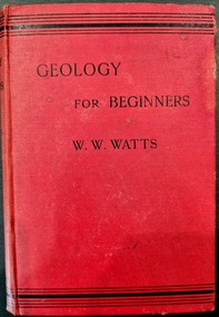
Book - Book - Course Text, W.W. Watts, Geology for Beginners, 1903
... Barker Library (top floor) Mount Helen goldfields Geology Red book of 352 pages and 322 illustrations. ...Red book of 352 pages and 322 illustrations.non-fictiongeology -
 Federation University Historical Collection
Photograph, Professor T.S Hart Head of Department 1897 - 1912
... Barker Library (top floor) Mount Helen goldfields Head of Geology department at School of Mines Ballarat which is a predecessor of Federation University professor t.s. hart head of department photograph geology Black and white Portrait of Professor T.S Hart Head of Department 1897 - 1912 in a red frame Professor T.S Hart Head of Department 1897 - 1912 Photograph ...Head of Geology department at School of Mines Ballarat which is a predecessor of Federation UniversityBlack and white Portrait of Professor T.S Hart Head of Department 1897 - 1912 in a red frameprofessor t.s. hart, head of department, photograph, geology -
 Federation University Historical Collection
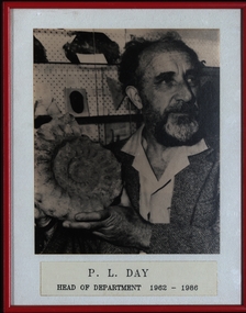
Photograph, P. L. Day Head of Department 1962 - 1986
... Barker Library (top floor) Mount Helen goldfields Head of Geology department at School of Mines Ballarat which is a predecessor of Federation University head of department photograph geology P. ...Head of Geology department at School of Mines Ballarat which is a predecessor of Federation UniversityBlack and white Portrait of P. L. Day Head of Department 1962 - 1986 in a red framehead of department, photograph, geology, p. l. day -
 Federation University Historical Collection
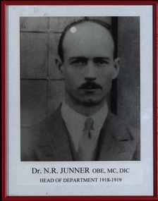
Photograph, Dr. N. R. Junner OBE, MC, DIC Head of Department 1918 - 1919
... Barker Library (top floor) Mount Helen goldfields Head of Geology department at School of Mines Ballarat which is a predecessor of Federation University head of department photograph geology P. ...Head of Geology department at School of Mines Ballarat which is a predecessor of Federation UniversityBlack and white Portrait of Dr. N. R. Junner OBE, MC, DIC Head of Department 1918 - 1919 in a red framehead of department, photograph, geology, p. l. day -
 Federation University Historical Collection
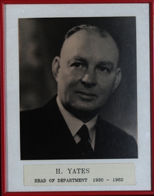
Photograph, H. Yates Head of Department 1920 - 1962
... Barker Library (top floor) Mount Helen goldfields Head of Geology department at School of Mines Ballarat which is a predecessor of Federation University head of department photograph geology P. ...Head of Geology department at School of Mines Ballarat which is a predecessor of Federation UniversityBlack and white Portrait of H. Yates Head of Department 1920 - 1962 in a red framehead of department, photograph, geology, p. l. day -
 Federation University Historical Collection
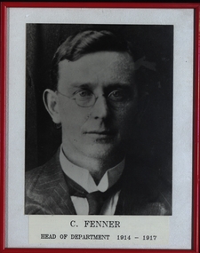
Photograph, C. Fenner Head of Department 1914 - 1917
... Barker Library (top floor) Mount Helen goldfields Head of Geology department at School of Mines Ballarat which is a predecessor of Federation University head of department photograph geology P. ...Head of Geology department at School of Mines Ballarat which is a predecessor of Federation UniversityBlack and white Portrait of C. Fenner Head of Department 1914 - 1917 in a red framehead of department, photograph, geology, p. l. day -
 Federation University Historical Collection
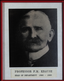
Photograph, Professor F. M. Krause Head of Department 1880 - 1895
... Barker Library (top floor) Mount Helen goldfields Head of Geology department at School of Mines Ballarat which is a predecessor of Federation University head of department photograph geology P. ...Head of Geology department at School of Mines Ballarat which is a predecessor of Federation UniversityBlack and white Portrait of Professor F. M. Krause Head of Department 1880 - 1895 in a red framehead of department, photograph, geology, p. l. day -
 Federation University Historical Collection
Geological specimen, Petrified wood
... Barker Library (top floor) Mount Helen goldfields petrified wood geology Three speimens of petrified wook Petrified wood Geological specimen ...Three speimens of petrified wookpetrified wood, geology -
Federation University Historical Collection
Book, Old Mines - New Vison: A Progres Report on Resurce Potenital Mount Lyell Mineral Field, 1992
... Barker Library (top floor) Mount Helen goldfields Mining Mount Lyell Geology geophysics metallurgy West Lyell Style North Lyell Style Copper Clay Style Hellyer Style A plastic bound report by Murray J. ...A plastic bound report by Murray J. Flintcroft and M.V. McKeown. INcludes photorgaphic reproductions such as the Owen Conglomerate, West Lyell Workshops, Glenn Lyell Alteration Zone, The Blow Opencut Looking North, Little Owen, mining, mount lyell, geology, geophysics, metallurgy, west lyell style, north lyell style, copper clay style, hellyer style -
Federation University Historical Collection
Article - Article - Women, Museums Australia: Women of Note; Lesley Kool, Paleontologist
... Barker Library (top floor) Mount Helen goldfields Lesley Kool is an honorary research associate in the Department of Vertebrate Palaeontology, Museums Victoria and does research in Palaeontology and Geology. ...Lesley Kool is an honorary research associate in the Department of Vertebrate Palaeontology, Museums Victoria and does research in Palaeontology and Geology. Her current project is 'Polar turtles from the Aptian of Victoria, Australia' plus research into the Early Cretaceous fauna and flora of Victoria. A group of researchers from Monash University, including mammalogist, palaeontologist and environmentalist decided to follow up on the discovery of Australia’s first dinosaur bone, the Cape Paterson Claw by William Ferguson, at Eagles Nest in 1903. Lesley Kool joined them. Together with colleagues, including Mike Cleeland of Phillip Island, she has made and researched discoveries over the following 40 years that have, among other things, completely turned worldwide theories on their head about the origins of mammals and how cold-blooded dinosaurs could have existed and thrived within the Antarctic Circle for millions of years. Reflecting on the importance of the work to which she has contributed she says: “These animals were as Australian as the koala and the kangaroo, but very few people are aware they ever existed. We would like to change that view.” Lesley was a Research Assistant at Monash University from 1986 to 2006. She then became Honorary Research Associate at Museums Australia in 2006. Lesley was awarded the Medal of the Order of Australia for Paleontology.women of note, academic, lesley kool, paleontologist, museums australia, honorary research associate, cape paterson claw, eagles nest, monash university, research assistant, medal of the order of australia -
Federation University Historical Collection
Document - Document - Syllabus, Education Department, Victoria, Technical School. Syllabuses for various subjects
... Library (top floor) Mount Helen goldfields The Education Department, Victoria, Syllabuses for Technical Schools. They include Mechanics (Applied) and Mechanics Applied to Mining (Syllabus No. 6), Mechanics and Heat (Syllabus No. 10), Municipal Engineering and Hydraulics (Syllabus No. 26), Engineering Drawing and Design (Syllabus No. 28), Electrical Engineering for Post Office Mechanics, Letter-Press Printing, Geology and Mining Geology (Syllabus No. 3), Electrical Wiring, Geology and Mining Geology (1914), Trade Teachers' Courses, Full Trade Courses, education department victoria syllabuses technical schools mechanics mechanics applied to mining mechanics and heat municipal engineering hydraulics engineering drawing and design electrical engineering post office mechanics letter-press printing geology mining geology electric wiring trade teachers full trade .1: Note at top written in pencil - 18/3/12 and Office Copy .2: Note at top right corner - Office Copy 7/6/13 8 sheets of A4 folded to make A5 document .1: Three syllabuses pinned together .2 to .8: Single syllabus Education Department, Victoria, Technical School. ...The Education Department, Victoria, Syllabuses for Technical Schools. They include Mechanics (Applied) and Mechanics Applied to Mining (Syllabus No. 6), Mechanics and Heat (Syllabus No. 10), Municipal Engineering and Hydraulics (Syllabus No. 26), Engineering Drawing and Design (Syllabus No. 28), Electrical Engineering for Post Office Mechanics, Letter-Press Printing, Geology and Mining Geology (Syllabus No. 3), Electrical Wiring, Geology and Mining Geology (1914), Trade Teachers' Courses, Full Trade Courses,8 sheets of A4 folded to make A5 document .1: Three syllabuses pinned together .2 to .8: Single syllabus.1: Note at top written in pencil - 18/3/12 and Office Copy .2: Note at top right corner - Office Copy 7/6/13education department, victoria, syllabuses, technical schools, mechanics, mechanics applied to mining, mechanics and heat, municipal engineering, hydraulics, engineering drawing and design, electrical engineering, post office mechanics, letter-press printing, geology, mining geology, electric wiring, trade teachers, full trade -
Federation University Historical Collection
Booklet - Booklet - Media Clippings, University of Ballarat: Community Service Activities, 1994
... Library (top floor) Mount Helen goldfields Booklet of article that appeared in the newspaper outlining events, programmes, etc. that are of community involvement. Computer and IT programmes; Uni helps kids learn about safe, active, healthy life; Uni eager to foster partnership with local community; Professor David James (Vice Chancellor) to be chair of regional consultation group reforming State's planning system; Ballarat's Martin Hughes of BU Geology Department and Queensland's Neil Phillips to present paper at Geological Society of America in Seattle; Uni to build aquatic centre to attract top swimmers; Open Days planned by Ballarat Universities; Sue Hadden, Ballarat Uni, received $75,000 grant to carry out research on Victoria's disappearing native grasses; Ballarat Uni to host major student sculpture show; Moves to develop high-tech park plan; New Research Plans assisted by Professor Tom O'Donnell; Indian experts look for answers to get more from their depleted desert forests; Uni conducts nursing survey re courses to be offered; Rabbit numbers rise - survey from farmers; Ted Lovett, VFL footballer (Fitzroy) talk on racism in sport at Ballarat Uni.; Australian beer awards at Ballarat Uni.; Study on Unhealthy Fitness - Heart Foundation suggests regular exercise at level suited to individual needs; Survey tracks path of yellow spotting; Tertiary push for hospital - Ararat; University considered for athletics facility; Top-level study on fitness for the elderly to be monitored by Human Movement and Sports Science students, University of Ballarat; Institute of Chartered Accountants will hold its annual accounting information day at the University of Ballarat's Foundation Hall. ...Booklet of article that appeared in the newspaper outlining events, programmes, etc. that are of community involvement. Computer and IT programmes; Uni helps kids learn about safe, active, healthy life; Uni eager to foster partnership with local community; Professor David James (Vice Chancellor) to be chair of regional consultation group reforming State's planning system; Ballarat's Martin Hughes of BU Geology Department and Queensland's Neil Phillips to present paper at Geological Society of America in Seattle; Uni to build aquatic centre to attract top swimmers; Open Days planned by Ballarat Universities; Sue Hadden, Ballarat Uni, received $75,000 grant to carry out research on Victoria's disappearing native grasses; Ballarat Uni to host major student sculpture show; Moves to develop high-tech park plan; New Research Plans assisted by Professor Tom O'Donnell; Indian experts look for answers to get more from their depleted desert forests; Uni conducts nursing survey re courses to be offered; Rabbit numbers rise - survey from farmers; Ted Lovett, VFL footballer (Fitzroy) talk on racism in sport at Ballarat Uni.; Australian beer awards at Ballarat Uni.; Study on Unhealthy Fitness - Heart Foundation suggests regular exercise at level suited to individual needs; Survey tracks path of yellow spotting; Tertiary push for hospital - Ararat; University considered for athletics facility; Top-level study on fitness for the elderly to be monitored by Human Movement and Sports Science students, University of Ballarat; Institute of Chartered Accountants will hold its annual accounting information day at the University of Ballarat's Foundation Hall. Students from other universities to attend; Prince Edward's visit - challenge of "Great Rubber Tube Raft Regatta" at Lake Wendouree; Uni, company in joint training initiative - installation on Novell's networking software in the degree course; Uni begins study into tree threat; Eureka leadership conference in Ballarat; Leadership conference an outstanding success.Buff coloured cover, black print. Pages glued and bound - black tape. Newspaper articles - photographs and print - on separate sheets in reverse order of appearance in paper; December to February.Symbol of University of Ballarat - cover.computer and it, newspaper items, health, local community involvement, david james, vice chancellor, state's planning system, martin hughes, geology department, neil phillips, queensland university, geological society of america, seattle, aquatic centre, sue hadden, research grant, $75000, native grasses, sculpture exhibitiontom o'donnell, indian experts, nursing survey, rabbit survey, ted lovett, footballer, racism in sport, australian beer awards, unhealthy fitness, heart foundation, athletics facility, fitness for the elderly, human movement and sports science, intitute of chartered accountants, networking system in degree course, eureka leadership conference -
 Federation University Historical Collection
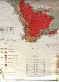
Map, Geological Map (Southern Western Australia), post 1880
... Barker Library (top floor) Mount Helen goldfields Includes the routes of exploration, including E. Giles, A. W. Howitt, Burke & Wills, Hume & Hovell, Major Mitchell, A Forrest. geology exploration railways electric telegraphs A section of a map showing geology and routes of exploration. ...Includes the routes of exploration, including E. Giles, A. W. Howitt, Burke & Wills, Hume & Hovell, Major Mitchell, A Forrest.A section of a map showing geology and routes of exploration. Southern Western Australia only geology, exploration, railways, electric telegraphs -
 Federation University Historical Collection
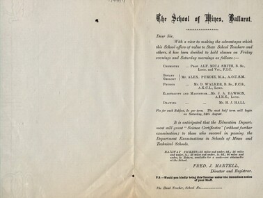
Leaflet, School of Mines: Classes for State School Teachers
... Library (top floor) Mount Helen goldfields The School of Mines in Ballarat decided to offer classes to teachers in State School. These areas were listed and the instructor named. Railway tickets were available from the school. It was hoped the this would enable these teachers to be awarded a "Science Certificate" through the Education Department if they succeeded. Subjects were: Chemistry with Prof Mica Smith; Botany/Geology ...The School of Mines in Ballarat decided to offer classes to teachers in State School. These areas were listed and the instructor named. Railway tickets were available from the school. It was hoped the this would enable these teachers to be awarded a "Science Certificate" through the Education Department if they succeeded. Subjects were: Chemistry with Prof Mica Smith; Botany/Geology with Alex Purdie; Physics with Mr D Walker; Electricity and Magnetism with Mr J Dawson; Drawing with Mr H Hall. Printed notice outlining classes for teachers in scienceballarat school of mines, state school teachers, science certificate, education department, chemistry, mica smith, botany, geology, alex purdie, physics, d walker, electricity, magnetism, j dawson, drawing, h hall -
 Federation University Historical Collection
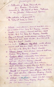
Document, SMB: Catalogue of a Collection of Rocks, Minerals, etc, 1883
... Barker Library (top floor) Mount Helen goldfields This list of rocks, minerals, etc. from Victoria was complied and forwarded by the School of Mines, Ballarat, to the Calcutta International Exhibition. At the end of the exhibition the items were to be presented to the Geological ...This list of rocks, minerals, etc. from Victoria was complied and forwarded by the School of Mines, Ballarat, to the Calcutta International Exhibition. At the end of the exhibition the items were to be presented to the Geological Survey of India. One Hundred items are listed. Pages 4 and 5 also show diagrams relating to the land formations and sections. Places in Victoria are named indicating where items were found. List compiled by Professor Ferdinand Moritz Krause. He joined Ballarat School of Mines in 1880 and lectured in Mineralogy and Geology. He was also the Curator of the Ballarat School of Mines Museum.6 pages, handwrittenSignature of F M Krause Dated 30th August 1883ballarat school of mines, rocks, minerals, calcutta international exhibition, geology survey of india, victoria, professor ferdinand moritz krause, mineralogy, geology, curator, ballarat school of mines museum -
 Federation University Historical Collection
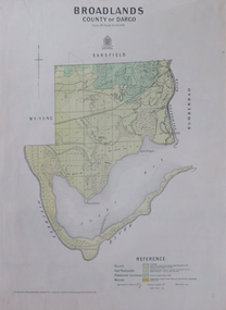
Map, Broadlands, County of Dargo, 1887
... Barker Library (top floor) Mount Helen goldfields broadford j.g. easton DARGO GEOLOGICAL Plan of Broadlands, County of Dargo, Victoria. ...Plan of Broadlands, County of Dargo, Victoria.broadford, j.g. easton, dargo, geological -
 Federation University Historical Collection
Plan, Ballark: County of Grant, 05/01/1889
... Barker Library (top floor) Mount Helen goldfields moreep mount wallace ballark A geological plan of Ballark in the County of Grant. ...A geological plan of Ballark in the County of Grant.moreep, mount wallace, ballark -
 Federation University Historical Collection
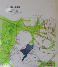
Map, Glenalbyn, County of Gladstone
... Barker Library (top floor) Mount Helen goldfields glenalbyn county of gladstone tarnagulla inglewood kingower kurting old inglewood deep lead salisbury west Copy of a geological map of Glenalbyn. ...Copy of a geological map of Glenalbyn. Some areas have been colours green. Creeks have been coloured blue, roads and reefs have been coloured orange.glenalbyn, county of gladstone, tarnagulla, inglewood, kingower, kurting, old inglewood deep lead, salisbury west -
 Federation University Historical Collection
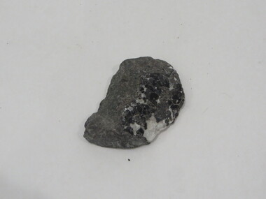
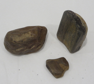
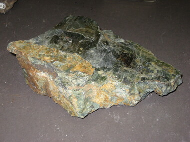
Rocks, Geological specimen
... Barker Library (top floor) Mount Helen goldfields From the Ballarat School of Mines. rocks geology Geological Specimen Geological specimen Rocks ...From the Ballarat School of Mines.Geological Specimenrocks, geology