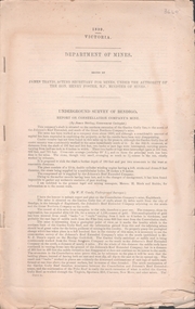
Showing 125 items matching "geologist"
-
 Federation University Historical Collection
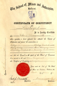
Certificate, Ballarat School of Mines Competency as a Geologist Certificate, o1/06/1911
... Ballarat School of Mines Competency as a Geologist Certificate ...William Baragwanath became Victorian Government Geologist. ...It is a Ballarat School of Mines Certificate of Competency as a Geologist made out to William Baragwanath in 1911. ...Ballarat School of Mines Competency as a Geologist Certificate Certificate ...William Baragwanath became Victorian Government Geologist. Cream coloured vellum certificate with blues Ballarat School of Mines Crest and red seal. It is a Ballarat School of Mines Certificate of Competency as a Geologist made out to William Baragwanath in 1911. The Certificate of Competency included passing examinations in Geology, Mining geology, Mineralogy, Petrology, Mine Surveying and Chemistry.Signed on left 'W. Baragwanath'ballarat school of mines, geology, petrology, mineralogy, surveying, chemistry, baragwanath, martell, frederick martell, maddern, geology alumni, william baragwanath -
 Federation University Historical Collection
Book, Northern Territory of South Australia Report Resulting from the Explorations by the Government Geologist, 1906, 1906
... Northern Territory of South Australia Report Resulting from the Explorations by the Government Geologist, 1906...Northern Territory of South Australia Report Resulting from the Explorations by the Government Geologist, 1906 Book Book C.E. Bristow, Government Printer C.E. ...Pale blue soft covered geological and general report. It includes a chapter of Bathurst Island and Melville Island, Primitive Methhods of Chinese Mining, Early Days of Mining in the Northern Territory Images include sandbank at low tide, Douglas River, Granite at Union Hill, Night Cliff, East Point, union hill, zapopan gold mine Brook's Creek, Blow Gold Mine Yam Creek, Daly River Copper Mine, Mount Ellison Copper Mine, Point Charles Lighthouse, Blacks Camp near Point Charles Lighthouse, The Venture Stranded on a Daly River Sandbank, Hyland Bay Natives, Boabab Trees at Blunder Bay, The Wai Hoi, Mouth of Fitzmaurice River, Point Blaze Natives, Fort Hill and Old Gulnare Jetty Port Darwin, Large Anthill, Daly RIver Natives, Wargie Natives, L.C.E. Gee, H.Y.L. Brown, H. Basedow. F.J. Williamson, Aboriginal crew (Pedro, Peter, Tobatchie, Bubs, Loman), Henry Roberts, Schollert's Grave It also includes a large folder Geological Map of the North-Western District Northern Territory of South Australia. northern territory of south australia, geology, l. o'loughlin, douglas river, bathurst island, melville island, apsley straight, chinese, aboriginal -
 Bendigo Historical Society Inc.
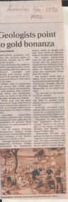
Newspaper - Kangaroo Flat Gold Mine Collection:, Department of Conservation and Environment, May 25/26 2002
... ...geologist...By using instruments that send vibrations into the earth, geologists will peel back the surface layers to expose a hidden landscape of buried hills, valleys and fossil streams, undiscovered gold and mineral wealth, and giant extinct volcanos. ...'Australian' newspaper article, 25/26th May, 2002, 'Geologists point to gold bonanza'. Article describes the $5 million Geotraverse research in Victoria, undertaken by CSIRO geologists, that 'estimate the northern plains of Victoria conceal up to 5000 tonnes of gold'. ...Bendigo mining gold CSIRO geologist geology Victorian Geotraverse project 'Australian' newspaper article, 25/26th May, 2002, 'Geologists point to gold bonanza'. ...Victoria will be sliced in half during the next two years by earth scientists who expect to reveal hidden mineral wealth and better understand land degradation caused by salinity. By using instruments that send vibrations into the earth, geologists will peel back the surface layers to expose a hidden landscape of buried hills, valleys and fossil streams, undiscovered gold and mineral wealth, and giant extinct volcanos. The $3 million project, called the Victorian Geotraverse, will attempt to expose the processes that shaped the state and helped form its mineral wealth. The project will be discussed at a conference, Victoria Undercover, in Benalla this week. Project leader Neil Phillips, chief of CSIRO Exploration and Mining, said the project would attempt to discover where the rest of Victoria's gold deposits might be found and where the next salinity disaster might strike. Using this process they will cut a 500-kilometre swathe through the Grampians, Bendigo, Benalla and Wodonga, curving down to Mallacoota on the far east coast. The project will involve 12 earth science agencies including the Victorian Department of Natural Resources and Environment, Geoscience Australia, the Cooperative Research Centre for Landscape, Environments and Mineral Exploration and the CSIRO. ('Age' newspaper, 28th April, 2002. https://www.theage.com.au/national/going-to-ground-for-state-secrets-20020428-gdu5tz.html Scientists will send shocks through the Victorian earth which will be reflected back and recorded on instruments that will reveal the density of the rocks below.'Australian' newspaper article, 25/26th May, 2002, 'Geologists point to gold bonanza'. Article describes the $5 million Geotraverse research in Victoria, undertaken by CSIRO geologists, that 'estimate the northern plains of Victoria conceal up to 5000 tonnes of gold'. Image on bottom of article, possibly S.T. Gill watercolour, titled 'Victorian miners pan for gold in the mid-1800's'.bendigo mining n.l., bendigo, mining, gold, csiro, geologist, geology, victorian geotraverse project -
 Bendigo Historical Society Inc.
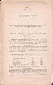
Document - GARDEN GULLY LINE OF REEF, LEASE BLOCKS 5360 AND 5361
... James Stirling, Government Geologist...History House 11 Mackenzie Street Bendigo goldfields BENDIGO Mining garden gully line of reef mines James Stirling, Government Geologist Two page document titled ' Report on lease blocks Nos. 5360 and 5361 Garden Gully line of reef, Bendigo. ...Two page document titled ' Report on lease blocks Nos. 5360 and 5361 Garden Gully line of reef, Bendigo. Produced by the Department of Mines 1899. The area described is about 'one mile and a quarter southeast from the centre of the city of Bendigo, immediately south of the Great Southern Gold Mining Company's workings and is intersected by two auriferous gullies ... Salomon's Gully and Derwenter's Gully'. The alluvial deposits, the Garden Gully line, the Great Souther Co.and old workings are discussed in the paper. A map of the Garden Gully line of reef is attached to the report, showing claimholders and mine names along that section of the reef. Mines named on the map: Great Southern Garden Gully United Ulster Londonderry Burrows Horwoods Sea Amalgamated Garden Gully United Victory and Pandora Unity Carlisle and Garden Gully and Passbye United Cornish United Koch's PioneerJames Stirling, Government Geologistbendigo, mining, garden gully line of reef mines -
Bendigo Historical Society Inc.
Photograph - KEN BICE COLLECTION: CENTRAL DEBORAH MINE, 1949
... ... geologist...Left Tom Rowe, visiting American geologists with Frank Chambers (Mines Department, geologist). ...Left Tom Rowe, visiting American geologists with Frank Chambers (Mines Department, geologist). ...Copy of photo: Two miners and two people dressed in dustcoats, underground. On back in stopes on the cap of the inner reef No. 8 level Central Deborah Mine, Bendigo, 1949. Left Tom Rowe, visiting American geologists with Frank Chambers (Mines Department, geologist). This is a digital only photograph.bendigo, mining, central deborah mine, bendigo, central deborah mine, tom rowe, frank chambers, geologist, mining, miners, american -
Hand Tool Preservation Association of Australia Inc
Hammer
... hammer, geologists...Hand Tool Preservation Association of Australia Inc No physical address melbourne This item is part of the Thomas Caine Tool Collection, owned by The National Trust of Australia (Victoria) and curated by the Hand Tools Preservation Association of Australia. hammer, geologists Hammer ...This item is part of the Thomas Caine Tool Collection, owned by The National Trust of Australia (Victoria) and curated by the Hand Tools Preservation Association of Australia.hammer, geologists -
 Bendigo Historical Society Inc.
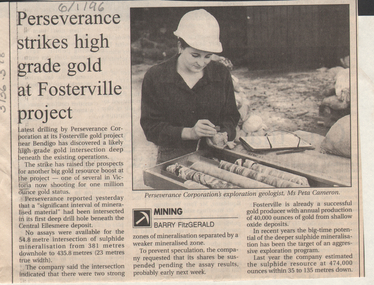
Newspaper - Kangaroo Flat Gold Mine Collection: Perseverance Gold, Fosterville
... ...geologist...Perseverance's exploration geologist Ms Peta Cameron, is pictured with core samples. ...Perseverance's exploration geologist Ms Peta Cameron, is pictured with core samples. ...Bendigo Advertiser article, 6th January 1996, 'Perseverance strikes high grade gold at Fosterville project'. Drilling at Fosterville has 'discovered a likely high grade gold intersection deep beneath the existing operations'. Perseverance's exploration geologist Ms Peta Cameron, is pictured with core samples. gold mining, bendigo, perseverance gold mine, fosterville, core samples, peta cameron, geologist -
 Bendigo Historical Society Inc.
Document - UNDERGROUND SURVEY OF BENDIGO MINES
... Jems Stirling, geologist and W.H Cundy Underground Surveyor, Department of Mines...History House 11 Mackenzie Street Bendigo goldfields BENDIGO Mining garden gully line of reef mines Jems Stirling, geologist and W.H Cundy Underground Surveyor, Department of Mines Two page document, 'Underground survey of Bendigo, report on Constellation Company's Mine on northern extension of the Garden Gully line of reef. ...Two page document, 'Underground survey of Bendigo, report on Constellation Company's Mine on northern extension of the Garden Gully line of reef. Report on the New Chum Railway Reserve Company and the Shenandoah Company, the New Chum Railway Co being immediately south and the Shenandoah Co immediately north of the railway line. Two maps Constellation Co. Mine shaft and New Chum Railway and Shenandoah auriferous reef below 2700 feet.Jems Stirling, geologist and W.H Cundy Underground Surveyor, Department of Minesbendigo, mining, garden gully line of reef mines -
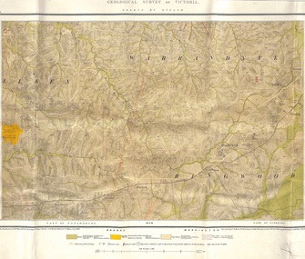 Ringwood and District Historical Society
Map, Geological Survey of Victoria - County of Evelyn, Published June 1893
... Surveyed by R.A. Moon, Field Geologist, under the supervision of R.A.F. Murray, Govt Geologist. ...Surveyed by R.A. Moon, Field Geologist, under the supervision of R.A.F. Murray, Govt Geologist. ...Markings include soil and rock types, alluvial gold workings, quartz reefs.Published under the direction of A.W. Howitt F.G.S. Secretary for Mines. The Hon J.H. McColl, Minister of Mines, June 1893. Surveyed by R.A. Moon, Field Geologist, under the supervision of R.A.F. Murray, Govt Geologist. Lithographed by J. M. Coakley. -
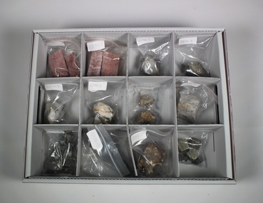 Bendigo Historical Society Inc.
Geological specimen - Rock Samples from Bendigo
... Identified as Bendigo rocks by a Geologist ...History House 11 Mackenzie Street Bendigo goldfields Identified as Bendigo rocks by a Geologist Bengio Rocks Geology A box of rock samples from Bendigo with 12 Compartments. ...Identified as Bendigo rocks by a Geologist A box of rock samples from Bendigo with 12 Compartments. Number 1 Pink rock with striations, 2 Pink rock with striations, 3 Grey rock with white vein, 4 Dark grey rock with one shiny surface, 5 White rock with gold, 6 White rock with shiny inserts, 7 White rock with shiny inserts, 8 Light grey with gold, 9 Dark grey rocks, 10 Dark grey rocks with shinny inserts, 11 Brown rock with crystal inserts, 12 group of cubes two shinny and the remainder black. Part of the Amy Huxtable Collection. bengio, rocks, geology -
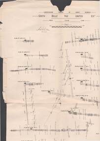 Bendigo Historical Society Inc.
Map - STRUGNELL COLLECTION: UNDERGROUND SURVEY OF MINES BENDIGO, 25/05/01
... Map, Underground Survey of Mines, Bendigo, South Belle Vue United Coy, New Chum Line, Surveyed under the Supervision of H.Herman,B.C.E.,F.G.S.,Acting Government Geologist....History House 11 Mackenzie Street Bendigo goldfields MAP Bendigo belle vue united coy A.S.Whitelaw Map, Underground Survey of Mines, Bendigo, South Belle Vue United Coy, New Chum Line, Surveyed under the Supervision of H.Herman,B.C.E.,F.G.S.,Acting Government Geologist. Map STRUGNELL COLLECTION: UNDERGROUND SURVEY OF MINES BENDIGO ...Map, Underground Survey of Mines, Bendigo, South Belle Vue United Coy, New Chum Line, Surveyed under the Supervision of H.Herman,B.C.E.,F.G.S.,Acting Government Geologist.A.S.Whitelawmap, bendigo, belle vue united coy -
 Bendigo Historical Society Inc.
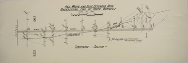
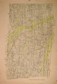
Map - RED WHITE AND BLUE EXTENDED MINE, 5/12/1940
... Caldwell, District Field Geologist, Mines Department Bendigo 5.12.1940...Caldwell, District Field Geologist, Mines Department Bendigo 5.12.1940 Map RED WHITE AND BLUE EXTENDED MINE ...Map: Transverse section of The Red, White and Blue Extended Mine, Sheepshead line of Reef, Bendigo. (9 Copies). By J.J. Caldwell, District Field Geologist, Mines Department Bendigo 5.12.1940map, bendigo, mining plan, red white and blue extended mine, sheepshead line of reef, mining , gold mines, j.j. caldwell -
Clunes Museum
Document - GEOLOGICAL REPORT, CIRCA 1897
... REPORT BY E. LIDGEY, FIELD GEOLOGIST, 1897...Clunes Museum 36 Fraser Street enter building through Collins Place Clunes goldfields REPORT BY E. LIDGEY, FIELD GEOLOGIST, 1897 local history document report mining SEE OVER REPORT ON AURIFEROUS ZONE FROM ROKEWOOD TO CLUNES, AND THENCE TO MOUNT CAMERON Document GEOLOGICAL REPORT ...REPORT BY E. LIDGEY, FIELD GEOLOGIST, 1897REPORT ON AURIFEROUS ZONE FROM ROKEWOOD TO CLUNES, AND THENCE TO MOUNT CAMERONSEE OVERlocal history, document, report, mining -
 Bendigo Historical Society Inc.
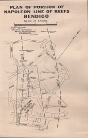
Document - MCCOLL, RANKIN AND STANISTREET COLLECTION: NAPOLEON REEF GOLD MINING CO. N.L, 5 December 1939
... Caldwell District Geologist, Mines Dept, Bendigo 5th Dec 1939....Caldwell District Geologist, Mines Dept, Bendigo 5th Dec 1939. ...Document: 4 Copies of plans showing part of lease No. 10970 (was 10873) and Central Napoleon Lode Channel, prepared by J.J. Caldwell District Geologist, Mines Dept, Bendigo 5th Dec 1939.organization, business, industrial - mining, mccoll rankin & stanistreet, mining, gold mining, napoleon reef -
 Bendigo Historical Society Inc.
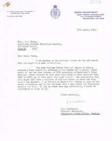
Document - CORRESPONDENCE: WILLIAM GRAHAM, 1974
... Correspondence re William Graham ca. 1870s from Master J P Graham (great-grandson) dated April 1974 and associated correspondence (Sec of BHS and H E Wilkinson, Bendigo District Geologist)....Correspondence re William Graham ca. 1870s from Master J P Graham (great-grandson) dated April 1974 and associated correspondence (Sec of BHS and H E Wilkinson, Bendigo District Geologist). Document CORRESPONDENCE: WILLIAM GRAHAM ...Correspondence re William Graham ca. 1870s from Master J P Graham (great-grandson) dated April 1974 and associated correspondence (Sec of BHS and H E Wilkinson, Bendigo District Geologist).person, individual, william graham, william graham, new moon company. -
 Ringwood and District Historical Society
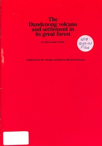
Book, The Dandenong Volcano and Settlement in its Great Forest, 1976
... This booklet fits together the geologist's story of the origins of the Dandenong Ranges with the story of settlement on them, from the first tiny group at Harmony Vale, as told in the manuscript "Corrhanwarrabul the Great Forest" in the possession of the Lilydale and District Historical Society....Ringwood and District Historical Society 125A Warrandyte Road Ringwood North melbourne This booklet fits together the geologist's story of the origins of the Dandenong Ranges with the story of settlement on them, from the first tiny group at Harmony Vale, as told in the manuscript "Corrhanwarrabul the Great Forest" in the possession of the Lilydale and District Historical Society. ...This booklet fits together the geologist's story of the origins of the Dandenong Ranges with the story of settlement on them, from the first tiny group at Harmony Vale, as told in the manuscript "Corrhanwarrabul the Great Forest" in the possession of the Lilydale and District Historical Society. -
Lakes Entrance Historical Society
Book, Walker Mary Howitt, Come Wind Come Weather A Biography of Alfred Howitt, 1971
... A comprehensive account of the remarkable and full life of one of Victorias outstanding pioneer settlers who in his lifetime as bushman explorer geologist naturalist anthropologist police magistrate and experimental farmer left his enduring mark on the hi...Lakes Entrance Historical Society 4 Marine Parade Lakes Entrance gippsland Settlers A comprehensive account of the remarkable and full life of one of Victorias outstanding pioneer settlers who in his lifetime as bushman explorer geologist naturalist anthropologist police magistrate and experimental farmer left his enduring mark on the hi Come Wind Come Weather A Biography of Alfred Howitt Book Walker Mary Howitt ...A comprehensive account of the remarkable and full life of one of Victorias outstanding pioneer settlers who in his lifetime as bushman explorer geologist naturalist anthropologist police magistrate and experimental farmer left his enduring mark on the hisettlers -
 Stawell Historical Society Inc
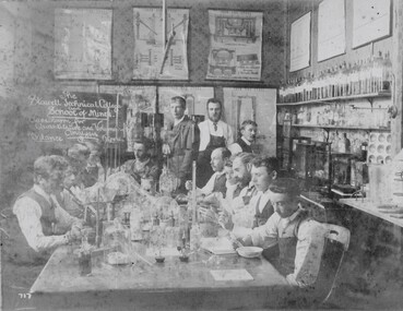
Photograph, School of Mines Stawell Analysis Classroom c1900
... Joseph Wearmouth was a Geologist & Metallurgist. ...Joseph Wearmouth was a Geologist & Metallurgist. Education The Stawell Technical College and School of Mines Classroom for Quantitative and Volumetric Analysis Balance Room Sepia Photograph of Classroom with students and teachers sitting around bench with laboratory glassware School of Mines Stawell Analysis Classroom c1900 Photograph ...J Wearmouth on back of photograph who probably attend the school. Joseph Wearmouth was a Geologist & Metallurgist. Sepia Photograph of Classroom with students and teachers sitting around bench with laboratory glasswareThe Stawell Technical College and School of Mines Classroom for Quantitative and Volumetric Analysis Balance Roomeducation -
 Federation University Historical Collection
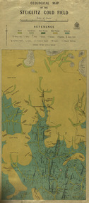
Map, Geological Map of The Stieglitz Gold Field, 1940
... Ferguson, Assistant Field Geologist. Published 1940."...Ferguson, Assistant Field Geologist. Published 1940." steiglitz geology geological map north albion moreep mining mine caribald reef durdidwarrah gilbraltar hill mount pleasant gully township of steiglitz W.H. ...At the bottom of the 2nd page, there is text that reads "Geologically and topographically surveyed in 1909 by W.H. Ferguson, Assistant Field Geologist. Published 1940."Rectangular geological map edged in masking tape showing Steiglitz, Victoria. Scale 48 chains to 4 inches.steiglitz, geology, geological map, north albion, moreep, mining, mine, caribald reef, durdidwarrah, gilbraltar hill, mount pleasant gully, township of steiglitz, w.h. ferguson, garibaldi reef, yankee gully, kinglock mine engine shaft, herbert werner frederick de nully, albion gully, virago reef, mulrooney's reef -
 Federation University Historical Collection
Article - Article - Women, Ballarat School of Mines: Women of Note; Jeanette Perkins, First Female Geology Student, (1927 - )
... ...geologist...She attended an interview with the principal (Heseltine) at the Ballarat School of Mines (SMB) and announced that she wanted to be a geologist. Heseltine was, according to Perkins, aghast: he informed her that there had never been a female geologist at SMB and they didn't want one. ...She attended an interview with the principal (Heseltine) at the Ballarat School of Mines (SMB) and announced that she wanted to be a geologist. Heseltine was, according to Perkins, aghast: he informed her that there had never been a female geologist at SMB and they didn't want one. ...Jeanette Perkins was born in 1927 at Ballarat. She attended Alfredton State School and Pleasant Street State School before completing her secondary schooling at Ballarat High School (BHS). During her later years at BHS Perkins decided that she wanted to become a geologist, but was ineligible for university when she failed Leaving Certificate maths. She attended an interview with the principal (Heseltine) at the Ballarat School of Mines (SMB) and announced that she wanted to be a geologist. Heseltine was, according to Perkins, aghast: he informed her that there had never been a female geologist at SMB and they didn't want one. But Perkins persisted. Only then did Heseltine reluctantly enrol her in the School's Applied Chemistry Course which offered the most geological subjects, moreover, it was the only one he considered available to a 'mere' female. After graduating Perkins was employed as a metallurgical chemist with M.B. Johns Valves, Ballarat. In 1949 she married Alfred Watson. In 1951 Jeanette and Alf Watson moved to Melbourne where she commenced work as a metallurgical chemist at the Maribyrnong Ordnance Factory while studying geology part time: Alf returned to study at the University of Melbourne. Once again, Watson set a precedent by becoming the first female student to study geology part-time at the Melbourne Technical College. Increasing demands brought about by her growing family, she turned to part-time lecturing second and third year stratigraphy and palaeontology at RMIT. In 1957 the Watsons moved to the Mary Kathleen Uranium Mine in NW Queensland where he was appointed electrical design engineer. After their return to Melbourne in 1960, Jeanette taught herself to SCUBA dive and quickly developed a passion for the sport and the marine environment. She taught senior science to secondary students for 10 years whilst working towards a Masters degree. In 1991 Jeanette Watson was awarded a Doctorate from Deakin University.women of note, ballarat school of mines, alfredton state school, pleasant street state school, ballarat high school, leaving certificate maths, interview with principal, heseltine, geologist, applied chemistry course, no female geologists, metallurgical chemist, married 1949, melbourne, ordinance factory, part time study, melbourne technical college, rmit, part time lecturer, scuba diving, science teacher for ten years, masters degree, doctorate, deakin university -
 Tarnagulla History Archive
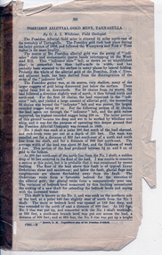
Pages from a book: Poseidon Alluvial Gold Mine, Tarnagulla, Poseidon Alluvial Gold Mine, Tarnagulla, circa 1916
... Whitelaw, Field Geologist. Includes a map (also extracted from the book) with title 'Poseidon Alluvial Gold Mines'. ...Whitelaw, Field Geologist. Includes a map (also extracted from the book) with title 'Poseidon Alluvial Gold Mines'. ...Murray Comrie Collection. Pages from a book (unknown), this excerpt titled 'Poseidon Alluvial Gold Mine, Tarnagulla' by O.A.L. Whitelaw, Field Geologist. Includes a map (also extracted from the book) with title 'Poseidon Alluvial Gold Mines'. Map of the mines entire workings, above and below ground. tarnagulla, poseidon, mine, mining, gold -
 Bendigo Historical Society Inc.
Document - VICTORIA HILL - LETTER TO MR WODETZKI FROM A. RICHARDSON
... He also mentions their geologist, Mr Eric Wilkinson may go over the area to determine what should be marked in regard to rock formations, etc. ...He also mentions their geologist, Mr Eric Wilkinson may go over the area to determine what should be marked in regard to rock formations, etc. ...Handwritten carbon copy of a letter from A Richardson to Mr Wodetzki and a few suggested spots for marking. He also mentions their geologist, Mr Eric Wilkinson may go over the area to determine what should be marked in regard to rock formations, etc. Albert Richardson collection.document, memo, victoria hill, victoria hill, letter to mr wodetzki from a richardson, mines dept, mr eric wilkinson, north old chum mine, ballerstedt's first open cut, lansell's big 180, ballerstedt's second open cut, ballerstedt jun'r, the crushing battery, the victoria quartz, rae's open cut, large cross spur or quartz vein, whip shaft, e j dunn -
 Bendigo Historical Society Inc.
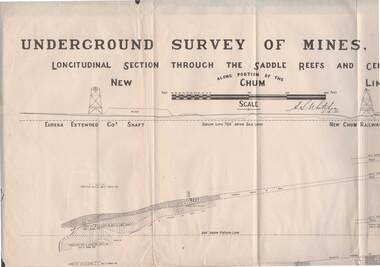
Map - STRUGNELL COLLECTION: NEW CHUM LINE OF REEF, 5/4/01
... Surveyed under the supervision of H.Herman, B.C.E., F.G.S., Acting Government Geologist....Surveyed under the supervision of H.Herman, B.C.E., F.G.S., Acting Government Geologist. Map STRUGNELL COLLECTION: NEW CHUM LINE OF REEF ...Map, Along portion of the New Chum Line, Underground Survey of Mines, Bendigo, Longitudinal Section through the Saddle Reefs and Centre Country. Eureka Extended Co's shaft, New Chum Railway Co's shaft. Surveyed under the supervision of H.Herman, B.C.E., F.G.S., Acting Government Geologist.H.S.Whitelowmap, bendigo, new chum line -
Glen Eira Historical Society
Document - HOWITT FAMILY
... ... Geologist...Information details his family history, religion, his medical affiliations, his garden in Collins St. 2/Two page print out from Wikipedia done 13/12/2013 on Godfrey Howitt giving family history and his medical history in Melbourne; includes a sketch of him. 3/Family tree map by Claire Barton. 4/Print out on Alfred William Howitt, taken from Monash website, on his life as an explorer, geologist and anthropologist. Monash University’s Howitt Hall is named in his honour....Bakewell Miss Howitt William Bakewell Phoebe Caulfield Howitt Alfred William Melbourne Hospital Benevolent Asylum Howitt William Godfrey Farms Entomologist Howitt John Henry Howitt Charles Medical School Committee University of Melbourne Philosophical Society of Victoria Royal Society of Victoria Magistrate Howitt Hall Explorer Geologist Anthropologist ‘Howittia’ blue-flowered mallow Document HOWITT FAMILY ...Four documents on the history of the Howitt family: 1/A photocopied extract on Dr. Godfrey Howitt, taken from biographical information in ‘A Woman of Importance’, by Jean Uhl. Information details his family history, religion, his medical affiliations, his garden in Collins St. 2/Two page print out from Wikipedia done 13/12/2013 on Godfrey Howitt giving family history and his medical history in Melbourne; includes a sketch of him. 3/Family tree map by Claire Barton. 4/Print out on Alfred William Howitt, taken from Monash website, on his life as an explorer, geologist and anthropologist. Monash University’s Howitt Hall is named in his honour.howitt godfrey dr., howitt mrs., bakewell miss, howitt william, bakewell phoebe, caulfield, howitt alfred william, melbourne hospital, benevolent asylum, howitt william godfrey, farms, entomologist, howitt john henry, howitt charles, medical school committee, university of melbourne, philosophical society of victoria, royal society of victoria, magistrate, howitt hall, explorer, geologist, anthropologist, ‘howittia’ blue-flowered mallow -
 Bendigo Historical Society Inc.
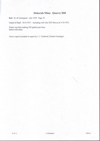
Document - MINING REPORTS - DEBORAH MINE - QUARRY HILL
... Caldwell, District Geologist. Ref. M. & Geological, July 1938. ...Caldwell, District Geologist. Ref. M. & Geological, July 1938. Page 29. ...Handwritten notes from a report by J. J. Caldwell, District Geologist. Ref. M. & Geological, July 1938. Page 29. Depth of Shaft 30 - 9 - 1937 - including well was 1025 feet as at 3 - 10 - 1932. Water was then making 500 gallons per hour. Baled with tanks.document, gold, mining reports, deborah mine quarry hill, m & geological, j j caldwell -
 Bendigo Historical Society Inc.
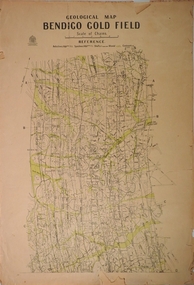
Map - STRUGNELL COLLECTION: BENDIGO GOLD FIELD GEOLOGICAL SURVEY, 1936
... Whitelaw, Field Geologist assisted by E. S. Usher & A. J. J. ...Whitelaw, Field Geologist assisted by E. S. Usher & A. J. J. ...BHS CollectionBendigo Goldfieds Geological Survey. Prepared in 1923 the Bendigo Office, mines Department under the direction of H. Herman, Director Geological Surveys by H. S. Whitelaw, Field Geologist assisted by E. S. Usher & A. J. J. Moore Re-Issued in 1936 Top Section of original map.Dept of Mines Victoriabendigo, gold mining, geological map, mines department, h. herman, h. s. whitelaw, e. s. usher, a. j. moore -
 Bendigo Historical Society Inc.
Map - STRUGNELL COLLECTION: BENDIGO GOLD FIELD GEOLOGICAL SURVEY, 1936
... Whitelaw, Field Geologist assisted by E. S. Usher & A. J. J. ...Whitelaw, Field Geologist assisted by E. S. Usher & A. J. J. ...BHS CollectionBendigo Goldfieds Geological Survey. Prepared in 1923 the Bendigo Office, mines Department under the direction of H. Herman, Director Geological Surveys by H. S. Whitelaw, Field Geologist assisted by E. S. Usher & A. J. J. Moore Re-Issued in 1936 Bottom Section of original map.Dept of Mines Victoriabendigo, gold mining, geological map, h. herman, h. s. whitelaw, e. s. usher, a. j. moore -
 Bendigo Historical Society Inc.
Document - MCCOLL, RANKIN AND STANISTREET COLLECTION: THE SEDGWICK GOLD MINE, 1930's
... Caldwell, Field Geologist...Caldwell, Field Geologist Document MCCOLL, RANKIN AND STANISTREET COLLECTION: THE SEDGWICK GOLD MINE ...Manilla Folder containing documents relating to the Sedgwick Gold Mine, formerly the Great Eastern. Including plan of area applied for lease No. 10414 by E. Peel. Comprehensive hand written description of mine from R. M. Williams. And record taken from the Bendigo office by J. Caldwell, Field GeologistMcColl Rankin & Stanistreetgold mining, miners' safety cage, sedgwick, gold mine, sedgwick, great eastern, geology -
 Bendigo Historical Society Inc.
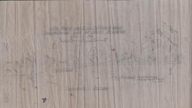
Map - RED WHITE & BLUE EXTENDED - PLAN OF RED WHITE AND BLUE EXTENDED MINE TRANSVERSE SECTION
... Signed by J J Caldwell, District Field Geologist, Mines Department, Bendigo and dated 5/12/1940. ...Signed by J J Caldwell, District Field Geologist, Mines Department, Bendigo and dated 5/12/1940. ...Transverse section of the Red White & Blue Extended Mine on the Sheepshead Line of Reef showing shafts, depths and geological features. Drawn on tracing film in pencil. Signed by J J Caldwell, District Field Geologist, Mines Department, Bendigo and dated 5/12/1940. Notes prepared by Albert Richardson.document, gold, red white & blue extended, red white & blue extended, plan of red white & blue extended mine transverse section, j j caldwell, mines dept bendigo -
 Bendigo Historical Society Inc.
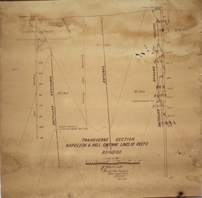
Plan - Napoleon, Nell Gwynne Transverse Section, 14.1.1946
... Caldwell, District Field Geologist, Mines Department, Bendigo. 14.1.46'. ...Caldwell, District Field Geologist, Mines Department, Bendigo. 14.1.46'. ...Napoleon Lease no.11111 is situated immediately south from the Golden Square railway station. It embraces an approx length of 36 chains of the Napoleon Anticline. The old Napoleon shaft, the depth of which is 1020 ft, occupies a central position in the area of about 43 acres. The accompanying sections, which are prepared from mine Managers plans, illustrate the extent of previous underground operations and indicate points at which future prospecting may be advantageously continued. The no.10 (920 ft) south level connects with the main Napoleon shaft no.5 level (479 ft) appears to present the best opportunity for testing the prospects that are believed to have been inadequately investigated by the Bendigo Mines Limited in recent years.Map drawn on heavy paper. Printed on bottom of plan" Transverse Section Napoleon and Nell Gwynne Lines of Reef' and 'J.J. Caldwell, District Field Geologist, Mines Department, Bendigo. 14.1.46'. Napoleon anticline and Central Nell Gwynne anticline marked on map. Map is part of the Margaret Roberts Collection of mining documents. gold mining, bendigo, napoleon gold mine, nell gwynne, reef lines, j.j. caldwell, 1946