Showing 140 items matching "gold workings"
-
 Federation University Historical Collection
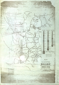
Plan, Plan of Leads and Gold Workings at Baallarat Showing the Complications Under the Frontage System, 1863, 1863
... Plan of Leads and Gold Workings at Baallarat Showing the Complications Under the Frontage System, 1863...Facsimile of a plan of Ballarat showing leads, gold workings an dthe frontage system....Barker Library (top floor) Mount Helen goldfields Facsimile of a plan held by the Public Record Office Victoria. ballarat mining inkermann lead golden point lead robert davidson terrible lead white horse lead frenchman's lead little magpie lead milkmaid's lead woolshed lead nuggety lead blackman's lead canadian lead sailor's gully lad nightingale lead malakoff lead black hill gully pennyweight flat black hill winter's pre-emptive right nelson company great extended great republic lead cgt Facsimile of a plan of Ballarat showing leads, gold workings an dthe frontage system. Plan of Leads and Gold Workings at Baallarat Showing the Complications Under the Frontage System, 1863 Plan Plan Robert Davidson Esq C.E. ...Facsimile of a plan held by the Public Record Office Victoria. Facsimile of a plan of Ballarat showing leads, gold workings an dthe frontage system.ballarat, mining, inkermann lead, golden point lead, robert davidson, terrible lead, white horse lead, frenchman's lead, little magpie lead, milkmaid's lead, woolshed lead, nuggety lead, blackman's lead, canadian lead, sailor's gully lad, nightingale lead, malakoff lead, black hill gully, pennyweight flat, black hill, winter's pre-emptive right, nelson company, great extended, great republic lead, cgt -
 Bendigo Historical Society Inc.
Slide - ALBERT RICHARDSON COLLECTION: CENTRAL DEBORAH GOLD MINE, UNDERGROUND WORKINGS
... ALBERT RICHARDSON COLLECTION: CENTRAL DEBORAH GOLD MINE, UNDERGROUND WORKINGS...Gold...underground workings....History House 11 Mackenzie Street Bendigo goldfields MINE Gold underground workings. Bendigo Mines-Jack Hattam Collection. ...Slide. . Level at 1045 feet at New Moon Gold Mine, Eaglehawk. Crushing material 70 feet in width. Two men drilling while five look on. Image sourced from 'Healthy Golden Bendigo'No. 43 printed on bottom of slidemine, gold, underground workings., bendigo mines-jack hattam collection. -
 Bendigo Historical Society Inc.
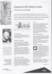
Document - DIAMOND HILL HISTORIC AREA PARKS VICTORIA
... On second page is a map of the area showing historic features: Deborah Consolidated Gold workings Red, White and Blue Extended gold workings Goldfields Extended gold workings Dead Dog Gully, alluvial gold workings Glasgow & Golconda Gold workings and tramway Surface gold mining site Hansel Mundy gold workings Bendigo Goldfields Pty gold workings Stafford gold workings Langdon gold workings Great Opossum Gully alluvial gold workings...On second page is a map of the area showing historic features: Deborah Consolidated Gold workings Red, White and Blue Extended gold workings Goldfields Extended gold workings Dead Dog Gully, alluvial gold workings Glasgow & Golconda Gold workings and tramway Surface gold mining site Hansel Mundy gold workings Bendigo Goldfields Pty gold workings Stafford gold workings Langdon gold workings Great Opossum Gully alluvial gold workings Document DIAMOND HILL HISTORIC AREA PARKS VICTORIA ...Document, two pages, prepared by Parks Victoria in relation to the Diamond Hill Historic Area. Contains information regarding the history of the area; German Miners; Plants and animals. On second page is a map of the area showing historic features: Deborah Consolidated Gold workings Red, White and Blue Extended gold workings Goldfields Extended gold workings Dead Dog Gully, alluvial gold workings Glasgow & Golconda Gold workings and tramway Surface gold mining site Hansel Mundy gold workings Bendigo Goldfields Pty gold workings Stafford gold workings Langdon gold workings Great Opossum Gully alluvial gold workingsbendigo, mining, diamond hill -
 Federation University Historical Collection
Plan, Station Reserve Bakery Hill, Ballaarat
... ...gold workings...Barker Library (top floor) Mount Helen goldfields Station reserve bakery hill railway Ballarat Mair Street Humffray Street NOrth Duke of York Hotel Duke of richmond hotel union hotel kingston st otway st Wellington Claim gravel pits gold workings Robert Burns Hotel .1) Oversized photocopy of large plan depicting railway right of way where Mair and Humffray Streets meet. ....1) Oversized photocopy of large plan depicting railway right of way where Mair and Humffray Streets meet. Main landmarks include Duke of Richmond Hotel, Prince of Wales Hotel, Duke of York Hotel, Welcome Nugget Claim and Shaft, Imperial Hotel, Union Hotel, Kingston St, Otway St, Wellington Claim, Gravel Pits Gold Working and Robert Burns Hotel. .2) Same of above. station reserve, bakery hill, railway, ballarat, mair street, humffray street north, duke of york hotel, duke of richmond hotel, union hotel, kingston st, otway st, wellington claim, gravel pits, gold workings, robert burns hotel -
 Federation University Historical Collection
Booklet, E.J. Dunn, The Back Creek Silver-Lead Mine, near Buchan, Eastern Gippsland, 1905, 1905
... ...taedato creek gold workings...gippsland buchan dickson's caves basin creek caves murrinfal river wilon's caves buchan limestone mt tara goldfield taedato creek gold workings dominion copper mine queen roeed micawbet mne surprise mine good hope mine Sixteen page booklet. ...Sixteen page booklet.gippsland, buchan, dickson's caves, basin creek caves, murrinfal river, wilon's caves, buchan limestone, mt tara goldfield, taedato creek gold workings, dominion copper mine, queen roeed, micawbet mne, surprise mine, good hope mine -
Stawell Historical Society Inc
Map, MPI Mines, Plan View of Township Area 2003, 13/6/2003
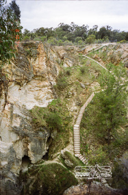
... Showing known old gold workings Stawell Gold Mines. 13 June 2003 ...Stawell Historical Society Inc 46 Longfield St Stawell grampians gold mining 1 : 7500 MPI Mines Showing known old gold workings Stawell Gold Mines. 13 June 2003 Plan View of Township Area 2003 Map MPI Mines ...goldShowing known old gold workings Stawell Gold Mines. 13 June 2003 1 : 7500 MPI Minesmining -
 Ringwood and District Historical Society
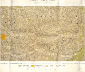
Map, Geological Survey of Victoria - County of Evelyn, Published June 1893
... Markings include soil and rock types, alluvial gold workings, quartz reefs....Markings include soil and rock types, alluvial gold workings, quartz reefs. Geological Survey of Victoria - County of Evelyn, Published June 1893 Map ...Markings include soil and rock types, alluvial gold workings, quartz reefs.Published under the direction of A.W. Howitt F.G.S. Secretary for Mines. The Hon J.H. McColl, Minister of Mines, June 1893. Surveyed by R.A. Moon, Field Geologist, under the supervision of R.A.F. Murray, Govt Geologist. Lithographed by J. M. Coakley. -
Stawell Historical Society Inc
Map, MPI Mines, Plan View of Township Area 2003, 13/6/2003
... Showing known gold workings & Houses Stawell Gold Mines. 13 June 2003 ...Stawell Historical Society Inc 46 Longfield St Stawell grampians gold mining 1 : 7500 MPI Mines Showing known gold workings & Houses Stawell Gold Mines. 13 June 2003 Plan View of Township Area 2003 Map MPI Mines ...goldShowing known gold workings & Houses Stawell Gold Mines. 13 June 2003 1 : 7500 MPI Minesmining -
Clunes Museum
Photograph, EXTENT OF MINE WORKINGS AT CLUNES, 1987
... AERIAL PHOTOGRAPH CLUNES GOLD WORKINGS MAP SUPERIMPOSED. MOUNTED ON CARDBOARD WITH DETAILS OF MINE LOCATION. ...Clunes Museum 36 Fraser Street enter building through Collins Place Clunes goldfields MINE WORKINGS IN CLUNES PORT PHILLIP MINE AERIAL PHOTOGRAPH QUARTZ MINING AERIAL PHOTOGRAPH CLUNES GOLD WORKINGS MAP SUPERIMPOSED. MOUNTED ON CARDBOARD WITH DETAILS OF MINE LOCATION. ...MINE WORKINGS IN CLUNESAERIAL PHOTOGRAPH CLUNES GOLD WORKINGS MAP SUPERIMPOSED. MOUNTED ON CARDBOARD WITH DETAILS OF MINE LOCATION. TYPED DESCRIPTION PASTED BELOW.port phillip mine, aerial photograph, quartz mining -
 Eltham District Historical Society Inc
Photograph, Balaclava Open Cut Mine near Whroo Historic Reserve; 9 Oct 1994, 20/11/1994
... Whroo Historic Reserve contains a number of interesting features relating to the former township and gold workings....Eltham District Historical Society Inc 728 Main Rd Eltham melbourne Whroo Historic Reserve contains a number of interesting features relating to the former township and gold workings. Record of the Society's history of activities - Spring 1994 excursion shire of eltham historical society activities whroo balaclava hill balaclava mine gold mining whroo historic reserve Kodak Gold 100-4 Roll of 35mm colour negative film, 4 strips Balaclava Open Cut Mine near Whroo Historic Reserve; 9 Oct 1994 Photograph ...Whroo Historic Reserve contains a number of interesting features relating to the former township and gold workings.Record of the Society's history of activities - Spring 1994 excursionRoll of 35mm colour negative film, 4 stripsKodak Gold 100-4shire of eltham historical society, activities, whroo, balaclava hill, balaclava mine, gold mining, whroo historic reserve -
 Eltham District Historical Society Inc
Photograph, Whroo Historical Area; 9 Oct 1994, 20/11/1994
... Whroo Historic Reserve contains a number of interesting features relating to the former township and gold workings....Eltham District Historical Society Inc 728 Main Rd Eltham melbourne Whroo Historic Reserve contains a number of interesting features relating to the former township and gold workings. Record of the Society's history of activities - Spring 1994 excursion shire of eltham historical society activities whroo balaclava hill balaclava mine gold mining whroo historic reserve Kodak Gold 100-4 Roll of 35mm colour negative film, 4 strips Whroo Historical Area; 9 Oct 1994 Photograph ...Whroo Historic Reserve contains a number of interesting features relating to the former township and gold workings.Record of the Society's history of activities - Spring 1994 excursionRoll of 35mm colour negative film, 4 stripsKodak Gold 100-4shire of eltham historical society, activities, whroo, balaclava hill, balaclava mine, gold mining, whroo historic reserve -
 Eltham District Historical Society Inc
Photograph, Balaclava Open Cut Mine near Whroo Historic Reserve; 9 Oct 1994, 20/11/1994
... Whroo Historic Reserve contains a number of interesting features relating to the former township and gold workings....Eltham District Historical Society Inc 728 Main Rd Eltham melbourne Whroo Historic Reserve contains a number of interesting features relating to the former township and gold workings. Record of the Society's history of activities - Spring 1994 excursion shire of eltham historical society activities whroo balaclava hill balaclava mine gold mining whroo historic reserve Kodak Gold 100-4 Roll of 35mm colour negative film, 4 strips Balaclava Open Cut Mine near Whroo Historic Reserve; 9 Oct 1994 Photograph ...Whroo Historic Reserve contains a number of interesting features relating to the former township and gold workings.Record of the Society's history of activities - Spring 1994 excursionRoll of 35mm colour negative film, 4 stripsKodak Gold 100-4shire of eltham historical society, activities, whroo, balaclava hill, balaclava mine, gold mining, whroo historic reserve -
 Eltham District Historical Society Inc
Photograph, Whroo Historical Area; 9 Oct 1994, 20/11/1994
... Whroo Historic Reserve contains a number of interesting features relating to the former township and gold workings....Eltham District Historical Society Inc 728 Main Rd Eltham melbourne Whroo Historic Reserve contains a number of interesting features relating to the former township and gold workings. Record of the Society's history of activities - Spring 1994 excursion shire of eltham historical society activities whroo balaclava hill balaclava mine gold mining whroo historic reserve Kodak Gold 100-4 Roll of 35mm colour negative film, 4 strips Whroo Historical Area; 9 Oct 1994 Photograph ...Whroo Historic Reserve contains a number of interesting features relating to the former township and gold workings.Record of the Society's history of activities - Spring 1994 excursionRoll of 35mm colour negative film, 4 stripsKodak Gold 100-4shire of eltham historical society, activities, whroo, balaclava hill, balaclava mine, gold mining, whroo historic reserve -
 Eltham District Historical Society Inc
Photograph, Whroo Historical Area; 9 Oct 1994, 20/11/1994
... Whroo Historic Reserve contains a number of interesting features relating to the former township and gold workings....Eltham District Historical Society Inc 728 Main Rd Eltham melbourne Whroo Historic Reserve contains a number of interesting features relating to the former township and gold workings. Record of the Society's history of activities - Spring 1994 excursion shire of eltham historical society activities whroo balaclava hill balaclava mine gold mining whroo historic reserve Kodak Gold 100-4 Roll of 35mm colour negative film, 4 strips Whroo Historical Area; 9 Oct 1994 Photograph ...Whroo Historic Reserve contains a number of interesting features relating to the former township and gold workings.Record of the Society's history of activities - Spring 1994 excursionRoll of 35mm colour negative film, 4 stripsKodak Gold 100-4shire of eltham historical society, activities, whroo, balaclava hill, balaclava mine, gold mining, whroo historic reserve -
 Federation University Historical Collection
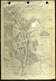
Plan, Creswick, Parish of Creswick, County of Talbot, 1928, 1928
... Parish Plan of Creswick showing Slaty Creek, Old Gold Workings, Police Reserve, Railway Station, Public Gardens, Sawpit Gully, Hospital Reserve, Nigh Soil Depot, Eureka Terracotta Tile COmpany, Creswick Creek, Forest COmmission, Roycroft's Race...creswick Eureka Terracotta Tile Co parish plan Parish Plan of Creswick showing Slaty Creek, Old Gold Workings, Police Reserve, Railway Station, Public Gardens, Sawpit Gully, Hospital Reserve, Nigh Soil Depot, Eureka Terracotta Tile COmpany, Creswick Creek, Forest COmmission, Roycroft's Race Creswick, Parish of Creswick, County of Talbot, 1928 Plan Plan Department of Lands and Survey ...Parish Plan of Creswick showing Slaty Creek, Old Gold Workings, Police Reserve, Railway Station, Public Gardens, Sawpit Gully, Hospital Reserve, Nigh Soil Depot, Eureka Terracotta Tile COmpany, Creswick Creek, Forest COmmission, Roycroft's Racecreswick, eureka terracotta tile co, parish plan -
Federation University Historical Collection
Map - Map - Geological, Geological Survey of Victoria - Ballarat, 09/1858
... The map show alluvial silt, gold drift, geological orders, volcanic, and gold workings. Scale is 8 chains to an inch. WGS 84 Centroid: 37 degrees 33 feet 33 inches south 143 degrees 52 feet 02 inches east W.E. extent: 5km NS extent: 3 km...The map show alluvial silt, gold drift, geological orders, volcanic, and gold workings. Scale is 8 chains to an inch. WGS 84 Centroid: 37 degrees 33 feet 33 inches south 143 degrees 52 feet 02 inches east W.E. extent: 5km NS extent: 3 km Geological Survey of Victoria - Ballarat Map Map - Geological J. ...Coloured Geological Map of Ballarat, edged with masking tape. The map show alluvial silt, gold drift, geological orders, volcanic, and gold workings. Scale is 8 chains to an inch. WGS 84 Centroid: 37 degrees 33 feet 33 inches south 143 degrees 52 feet 02 inches east W.E. extent: 5km NS extent: 3 kmballarat, ballaarat, geology, goldfield, phillips, j. phillips, mining, alfred selwyn, ferguson and mitchell -
 Bendigo Historical Society Inc.
Plan - Central Blue Gold Mine, Unknown
... Longitudinal plan of Central Blue and Little 180 gold mines underground workings. Hand drawn in pencil, with shadings. ...Korong Road. gold mining gold Bendigo central blue Longitudinal plan of Central Blue and Little 180 gold mines underground workings. Hand drawn in pencil, with shadings. ...Lansell's Little 180 gold mine was located on the corner of Alley Street and Mt. Korong Road. Longitudinal plan of Central Blue and Little 180 gold mines underground workings. Hand drawn in pencil, with shadings. Shafts marked: Central Blue and Sheepshead shaft. Plan forms part of the Margaret Roberts Collection.gold mining, gold, bendigo, central blue -
 Ballarat Tramway Museum
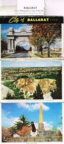
Postcard - Folder set, John Sands and Co, "City of Ballarat", c1950
... Colour - Arch of The Avenue of Honor, Ballarat from Black Hill showing gold workings, Eureka Stockade, The Begonia Conservatory Botanic Gardens, Sturt St between Grenville St and Lydiard St, the floral clock with the Town Hall in the background, The Ballarat Hospital and Autumn in the Botanic Gardens. ...Colour - Arch of The Avenue of Honor, Ballarat from Black Hill showing gold workings, Eureka Stockade, The Begonia Conservatory Botanic Gardens, Sturt St between Grenville St and Lydiard St, the floral clock with the Town Hall in the background, The Ballarat Hospital and Autumn in the Botanic Gardens. ...Yields information about the city of Ballarat late 1940's or early 1950's through a set of photographs and has a strong association with well known photographer - Frank Hurley.Folder of postcards or photographs of the City of Ballarat, photographs by Capt. Frank Hurley, late 1940's or very early 1950's. Series of 7 colour photographs on one side and five black and whites on the other. Colour - Arch of The Avenue of Honor, Ballarat from Black Hill showing gold workings, Eureka Stockade, The Begonia Conservatory Botanic Gardens, Sturt St between Grenville St and Lydiard St, the floral clock with the Town Hall in the background, The Ballarat Hospital and Autumn in the Botanic Gardens. Has a title "City of Ballarat", with a folder tab at the top. Black and white photographs "Ballarat Monument to the Golden Age (The gold monument), Sturt St looking west from the town hall, The City Hall, Ballarat Looking NE from the City Hall with the post office in the foreground and the "The flight from Pompeii - Botanical Gardens" Printed by John Sands and Co.trams, tramways, ballarat, postcards, sturt st, town hall, floral clock, eureka, botanical gardens, hospital, post office, black hill, floral clock -
 Bendigo Historical Society Inc.
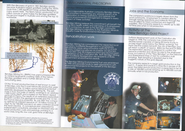
Flyer - Kangaroo Flat Gold Mine Collection: New Bendigo Gold Project, Unknown
... The New Bendigo Gold Project began surface workings at the Carshalton site in Kangaroo Flat, in 1998. ...The New Bendigo Gold Project began surface workings at the Carshalton site in Kangaroo Flat, in 1998. ...The New Bendigo Gold Project began surface workings at the Carshalton site in Kangaroo Flat, in 1998. A decline tunnel was constructed and designed to reach a depth of 800 m below the surface, passing underneath historic workings. The information brochure was produced to provide information to Bendigo community members.Colour trifold information brochure (2 copies). On front: 'New Bendigo Gold Project, Bendigo Mining N.L'. Brochure details background of project, environmental philosophy, rehabilitation work, jobs in the economy and current activity on the New Bendigo Gold Project. bendigo mining n.l., bendigo, mining, gold, kangaroo flat, environmental study -
 Bendigo Historical Society Inc.
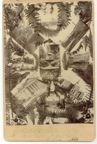
Photograph - CHRISTMAS CARD COLLAGE OF BENDIGO VIEWS
... Above ground mine workings. Lansell's Gold-mine with Needle chimney. ...Above ground mine workings. Lansell's Gold-mine with Needle chimney. Beehive Stock Exchange. ...Photographic collage of 9 Bendigo scenes designed as Christmas card. Bendigo Hospital. Camp Hill School. Capital Theatre. Alexandrina Fountain. Fountain in Fernery. Above ground mine workings. Lansell's Gold-mine with Needle chimney. Beehive Stock Exchange. Unknown female statue in Fernery. Estimated date 1875. Initials AB at bottom right corner.Unknownbendigo, buildings, heritage buildings -
 Bendigo Historical Society Inc.
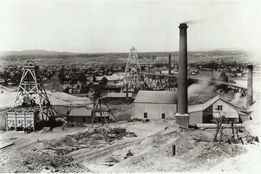
Photograph - NEW CHUM MINE WORKINGS
... Back ' mining gold Bendigo Vic. Mine workings - near New Chum Mine. ' not to be reproduced without permission from the National Library. ...Back ' mining gold Bendigo Vic. Mine workings - near New Chum Mine. ' not to be reproduced without permission from the National Library. ...black and white photo ; ( copy ) view from Chum Hill, poppet heads, buildings and chimneys in middle foreground, residential area in background. On front 545. Back ' mining gold Bendigo Vic. Mine workings - near New Chum Mine. ' not to be reproduced without permission from the National Library. James Lerk 18.2.2000 ; ' view from Chum Hill, left Lazarus Mine, right Lansell's 222 looking south 'organization, business, new chum mine -
Tarnagulla History Archive
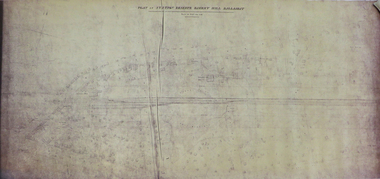
Set of Maps (Mining & Local Area), various
... Time-Lease Graph for Watts Reef, Specimen Reef, Stony Reef, Poverty Reef (second page in detail), created by Eric WIlkinson for Ref Mining NL, 1995 11. 1859 Plan of the Gold Workings & Township of Sandy Creek, Shewing the Mining Leases, Extended Claims & Machinery by R.J. ...Time-Lease Graph for Watts Reef, Specimen Reef, Stony Reef, Poverty Reef (second page in detail), created by Eric WIlkinson for Ref Mining NL, 1995 11. 1859 Plan of the Gold Workings & Township of Sandy Creek, Shewing the Mining Leases, Extended Claims & Machinery by R.J. ...David Gordon Collection. A set of mining documents, maps and plans: 1. Dunolly Deep Leads - showing location and names of deep lead gold deposits in region around Dunolly including at Tarnagulla and Newbridge. Geological Survey of Victoria, Department of Minerals and Energy. Bulletin No. 62, Map No. 4 Dunolly (770 x 485 mm). 2. Poseidon Lead (Facsimile) 3. Nick O Time Lead (Facsimile) 4. Happy Go Lucky Mine prospectus and plan (colour copy) 5. Jones Creek GM Co. (Raven & Gourlay's) Waanyarra - Prospectus (colour copy) 6. Poseidon Area Plan (colour copy) and Poseidon Area map (B&W copy). 7. Cross-section diagram of Spread Eagle Reef 8. New Birthday Gold Mine - area map (colour copy) and mine cross-section ( (colour copy). 9. Cross section of Poverty Reef, by Department of Mines (B&W copy, 2 parts on A2 paper) 10. Time-Lease Graph for Watts Reef, Specimen Reef, Stony Reef, Poverty Reef (second page in detail), created by Eric WIlkinson for Ref Mining NL, 1995 11. 1859 Plan of the Gold Workings & Township of Sandy Creek, Shewing the Mining Leases, Extended Claims & Machinery by R.J. McMillan, Mining Surveyor (B&W copy) 12. Longitundinal and Transverse Vertical Sections of Poverty Reef, Sandy Creek 1859, by R.J. McMillan, Mining Surveyor (B&W copy) 13. Tarnagulla Locality Plan (B&W copy) 14. Universal Grid Reference Map (Topographic) for Laanecoorie North (2 copies) 15. Universal Grid Reference Map (Topographic) for Inglewood South 16. Poverty Reef, Plan showing shafts and early tenements, created by Eric WIlkinson for Ref Mining NL, 1995 17. Locality Map of mining leases in Tarnagulla 18. Plan and Elevation of part of Poverty Reef, Sandy Creek, showing the claims and positions of the shaft. by R.J. McMillan, Mining Surveyor (Facsimile, composed of taped together components) 19.Plan and Elevation of part of Poverty Reef, Sandy Creek, showing the claims and positions of the shaft. by R.J. McMillan, Mining Surveyor (Facsimile, composed of taped together components) -
 Bendigo Historical Society Inc.
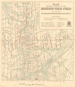
Map - DEPARTMENT OF MINES VICTORIA : PLAN SHOWING PORTION OF THE BENDIGO GOLD FIELD
... , shaft sites, area of Main Goldfield, Deepest mine workings, Gold output of field to 1935, and Dividends paid 1870 - 1935...., shaft sites, area of Main Goldfield, Deepest mine workings, Gold output of field to 1935, and Dividends paid 1870 - 1935. ...Department of Mines Victoria. Plan showing portion of the Bendigo Gold Field. On the back is written, in ink, J. J. Tyler 1937 Northern Area. (He was a teacher at Bendigo High - see donation notes). Across the bottom of the map is written ' M. Hill cr. Myrtle & Barnard' .The named reef lines have been numbered with ink across the bottom of the map. The gullies have been coloured with green pencil and a red pencil line is drawn through the western side of the map. Additional information: anticlinal axial lines at surface, alluvial workings, shaft sites, area of Main Goldfield, Deepest mine workings, Gold output of field to 1935, and Dividends paid 1870 - 1935.bendigo, gold mining, bendigo gold field. gold mining. tyler, j. j. -
 Bendigo Historical Society Inc.
Document - GARDEN GULLY LINE OF REEF, LEASE BLOCKS 5360 AND 5361
... The area described is about 'one mile and a quarter southeast from the centre of the city of Bendigo, immediately south of the Great Southern Gold Mining Company's workings and is intersected by two auriferous gullies ... ...The area described is about 'one mile and a quarter southeast from the centre of the city of Bendigo, immediately south of the Great Southern Gold Mining Company's workings and is intersected by two auriferous gullies ... ...Two page document titled ' Report on lease blocks Nos. 5360 and 5361 Garden Gully line of reef, Bendigo. Produced by the Department of Mines 1899. The area described is about 'one mile and a quarter southeast from the centre of the city of Bendigo, immediately south of the Great Southern Gold Mining Company's workings and is intersected by two auriferous gullies ... Salomon's Gully and Derwenter's Gully'. The alluvial deposits, the Garden Gully line, the Great Souther Co.and old workings are discussed in the paper. A map of the Garden Gully line of reef is attached to the report, showing claimholders and mine names along that section of the reef. Mines named on the map: Great Southern Garden Gully United Ulster Londonderry Burrows Horwoods Sea Amalgamated Garden Gully United Victory and Pandora Unity Carlisle and Garden Gully and Passbye United Cornish United Koch's PioneerJames Stirling, Government Geologistbendigo, mining, garden gully line of reef mines -
 Bendigo Historical Society Inc.
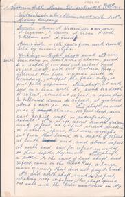
Document - ALBERT RICHARDSON COLLECTION: VICTORIA HILL MINES
... gold.' Owners of mine. Messrs A. Witrtschiebe, A. Sagasser, F. Meison, A. Urban, H. Koch, C. Killian and A. Rudolf. Document details the claim, the shafts sunk, their depth, issues re workings and gold found....gold.' Owners of mine. Messrs A. Witrtschiebe, A. Sagasser, F. Meison, A. Urban, H. Koch, C. Killian and A. Rudolf. Document details the claim, the shafts sunk, their depth, issues re workings and gold found. ...Two page handwritten document titled 'Victoria Hill Mines, Dickers M.R. 23.11.1861. Wittschiebe and Co. Claim. Next north to No. 2, Midway Company' Transcribed by Albert Richardson. Extract from text: 'There are reefs passing through this ground at small intervals in every part of this claim, they all dip north. The mass of leaders struck in No. 4 (shaft) yielded, on an average about 1 1/2 ounces to the ton to the amount, in all, of about 12,000 pounds. From the eastern Victoria, the present proprietors extracted in nine months 55,000 pounds worth of gold.' Owners of mine. Messrs A. Witrtschiebe, A. Sagasser, F. Meison, A. Urban, H. Koch, C. Killian and A. Rudolf. Document details the claim, the shafts sunk, their depth, issues re workings and gold found.Albert Richardsonbendigo, mining, wittschiebe & co. claim -
Federation University Historical Collection
Document, Zelda Martin, Central Victorian Goldmining towns - Boom Towns or Ghost Towns?, c1996
... *Post Office Directory -Daylesford and Hepburn Dunolly / Inkerman: *Brief History *Directory *Pamphlet - Goldfields Historical Museum *Pamphlet - Historic Dunolly - Victoria's Best Kept Secret *Map of Gold Workings at Dunolly Area - showing where the main gold rushes occurred *Brief History - Inglewood *Directory - Inglewood - Name Occupation, Dwelling Kingower: *Brief History *Directory - Name / Ocupation / Dwelling Linton / Happy Valley / Piggoreet: *Brief History *Directory - Lintons McIvor: *"A History of the Shire and the Township of Heathcote" by J.O. ...*Post Office Directory -Daylesford and Hepburn Dunolly / Inkerman: *Brief History *Directory *Pamphlet - Goldfields Historical Museum *Pamphlet - Historic Dunolly - Victoria's Best Kept Secret *Map of Gold Workings at Dunolly Area - showing where the main gold rushes occurred *Brief History - Inglewood *Directory - Inglewood - Name Occupation, Dwelling Kingower: *Brief History *Directory - Name / Ocupation / Dwelling Linton / Happy Valley / Piggoreet: *Brief History *Directory - Lintons McIvor: *"A History of the Shire and the Township of Heathcote" by J.O. ...Zelda Martin was a PhD candidate at the University of Melbourne.[.1] 4th item in light blue display book titled Research Approach/Overview of Chapters/Confirmation of Canditure/Chapters1,2,3&4 of proposed thesis. *Twenty-seven page article on Victorian goldfields towns titled: Central Victorian Goldmining Towns - Boom Towns or Ghost Towns. The article was written during the author's PhD study. It outlines the context methodology, and resources and the chapters of the proposed thesis: (1) Central Victorian Goldmining Towns - The Context (2) Contemporary Views of the Factors Necessary for Town Growth (3) Outward Manifestations of Town Growth (4) The Trappings of Government (5-9) The Main Towns and Their Hinterland. [.2] 5th item in Light Blue display book as above item. *Chapter 1 of proposed thesis titled 'Pick, Shovel and Tin Dish Mining.' Covers in Section A: Central Victoria - Pre 1851: Aborigines in Central Victoria, Squatters, and Government. Section B: The years 1851-1854: The Early Gold Rushes, Government Reaction, Township Surveys, Legislation, Town Development, Local Government and Early Settlement. [.3] 6th item in Light Blue display book as above item. *2A of proposed thesis titled 'Contemporary Views of the Factors Necessary for Town Growth'. Similar information to Chapter 1 plus extra re towns and maps. Sections: Introduction, Context of Place - Geographical Towns Listed, The Context of Time - Pre1851 Aborigines, Governance of Port Phillip, The Squatters, The Villages of Central Victorian Highlands, Conclusion, Condensed Version of Chapter2B. [.4] 7th item in Light Blue display book as above item. *Chapter2B of proposed thesis. Sections: Area of Research, Schools, Banks, Newspapers, Progress Association, Town Development - Sandhurst (Bendigo), Ballarat, Castlemaine,, Maryborough, Ararat and Stawell. [.5] 8th item in Light Blue display book as above item. *Chapter 3 of proposed thesis titled 'Outward Manifestations of Town Growth'. Sections: Introduction, Contemporary Writing, Educationalists, The Bankers, The Townsfolk, Current Theory, General Theories of Urban Development, and Conclusion. [.6] 9th item in Light Blue display book as above item. *Chapter 4 of proposed thesis titled 'Trappings of Government' Sections: Introduction, Early Government Attitudes to Mining and Town Development, Law and Order, Township Surveys, Legislation, Local Government, Transport and Communication, The People and Lobbyists. [.7] 10th item in Light Blue display book as above item. *'The Rise and Fall of Central Victorian Goldmining Towns'. Includes a map showing main Goldfields, a table showing towns and villages at two points in time - 1857 and 1871; a Bibliography of Primary and Secondary Sources. [.8] Resource No1. Black display book titled Local Towns 1 : Alma: *Brief history *Directory *Maps Amphitheatre / Mountain Hut: *Brief History Post Office Directory Ararat: *Brief History *Post Office Directory 1869 - Alphabetical Listing by Occupation *Ararat - Prominent Citizens of 1858 *Langi-Morgala Museum Avoca: *Brief History *Excerpts from 'Avoca The Early Years', Margery and Betty Beavis; pg1 - Beginnings; pg11 - The Midas Touch; pg25 - Local Gold Escorts; pg27 - A Town is Born; pg51- The Administration of Justice; pg53 - The Ways of the Law; pg61 - News of the Day; pg65 - A Time to Play; pg72 - Land Ownership *Post Office Directory (Bailliere's) 1869 *Tourism Map and Information of area *Historic Avoca - A 5.5km Tour *Avoca & the Pyrenees Region - information pamphlet Ballarat: *Early History of Ballarat - Ballarat Historical Society, Publication No.1: origin of the name; Ballaarat - the Beginning; Fabulous Yields from the Ballaarat Goldfield; *Streetscape Lydiard Street. *Hand drawn map showing Leigh River, Old Portland Bay Road, plaque on road to Colac; etc. *Newspaper article re 'The Theatre Royal' ( which stood in the vicinity of the current Owen Williams store) - 'The News'15/04/1998 *Article - 'Ballarat's Mechanics' Institute Lives On' Ballarat Courier, 14/09/1985 *Article - Standing the Test of Time' The News 17/11/1993 re The Mechanics Institute & picture of the Reading Room *'Ballarat a Study of a City, Phyllis Reichl, pub. Nelson, 1968; no.3 place, time and people field studies series *Investigator Vol.33 No.2, 1998 Geelong Historical Society. Article on pg75 describes Ballarat in 1861 *Folded poster - 'Ballarat 100' a history of telegraph communication, pub. Telecom. Beaufort (Fiery Creek): *Brief history *Post Office Directory [.9] Resource No.2 Black Folder Titled Towns cont.No2 Bendigo (Sandhurst): *'Family & Local History at the Bendigo Library - 1851-2001 150 years of gold'. *Bendigo Government Camp in 1853 illustration; key to sketch and names of Government officers stationed there *Excerpts from 'Bendigo and Vicinity' Adolph Haman *The Bendigo Goldfield Registry - pgs 1-7 Introduction *Excerpt: 'Breaking the Grip' *Excerpt: The Most Go-Ahead Place *Excerpts from 'History of Bendigo' - anti license agitation; laying out of town; proposed railway; gold calls and dividends; the Sandhurst Municipality; journalism *Bibliography Blackwood: *Excerpts from 'Aspects of Early Blackwood - The Goldfield, the Landmarks, the Pioneers' Alan J Buckingham and Margaret F Hitchcock, JG Publishing,1980 Buninyong: *A Brief History *Investigator Vol1 No.2 Feb 1966 Geelong Historical Society. Pg3 - Article re gold escort route - Mt Alexander to Adelaide - (see a simple monument on the Western Highway a few miles out of Horsham. Pg 15 - Ballarat Excursion - re the finding of gold. *Three articles published by Buninyong and District Historical Society Inc: (Magpie Exploration; Finding Gold In The Green Hills; Magpie Exploration; Burnt Bridge to Cargarie to Mt Mercer) *Copies of newspaper articles/items *Buninyong Street Directory Carisbrook: *In the Beginning There Was Carisbrook *The History of the Carisbrook Racecourse Carngham / Snake Valley: *Brief History *Directory Castlemaine: *Directory 1865-1866 - Alphabetical and Street *Poster - Castlemaine A Contemporary Guide "The Great Centre" 1866 - A Contemporary Guide to the Fascinating Past *Pamphlet - Castlemaine District Community Hospital *Map - Castlemaine, Maldon & Surrounding Districts *Map and Information - The Dry Diggings Track - a 55kl walk among historic goldfields relics ( Castlemaine Fryerstown Vaughan Mt Franklin Hepburn Daylesford) *Postcard - Former Court House *Directory 1867 - Alphabetical, Trade [.10] Resource No.3 Grey folder Titled Towns 3 Creswick to Maryborough Creswick: *Brief History *Booklet - "Creswick Cemetery Walk" *Booklet - The Buried Rivers of Gold Heritage Trail Creswick *Creswick Historical Museum Information Sheet *Chronological History of Creswick *Alphabetical Directory of the Borough of Creswick *Creswick's Creek Directory 1856 *Historic Creswick Walking Tour *A Brief Account of the Schools of Creswick - Past and Present *100 Years of Railway Travel in Creswick *The Berry Deep Leads *The Spence Home at Jackass Gully in the Creswick State Forest ( William Guthrie Spence - Pioneer) *The New Australian Mine and the 1882 Disaster *Creswick District News, Issue 7, July August 1999 *The Creswick Miners Walk - Information and Map *Maps Chewton: *Brief History *Directory Clunes: *Brief History *Clunes Street Directory Daylesford: *Brief History *Notable Bushfires in Daylesford District Over More Than a Century - "Black Thursday" 1851; 1862; 1899; the Disastrous Hepburn Fire of 1906; 1939; 1944; 1969. *Post Office Directory -Daylesford and Hepburn Dunolly / Inkerman: *Brief History *Directory *Pamphlet - Goldfields Historical Museum *Pamphlet - Historic Dunolly - Victoria's Best Kept Secret *Map of Gold Workings at Dunolly Area - showing where the main gold rushes occurred *Brief History - Inglewood *Directory - Inglewood - Name Occupation, Dwelling Kingower: *Brief History *Directory - Name / Ocupation / Dwelling Linton / Happy Valley / Piggoreet: *Brief History *Directory - Lintons McIvor: *"A History of the Shire and the Township of Heathcote" by J.O. Randell Majorca: *Brief History *Official Post Office Directory 1869 - Name / Occupation/ Address Maldon (Tarrangower): *Brief History Part 1 *Brief History Part 2 *Post Office Directory *List - Alphabetical Order by Names plus Business and Trade (Tarrangower Times Oct/1858) *List - Alphabetical Order by Trade plus Name and Business *Directory - Name / Occupation / Dwelling Maryborough: *Worsley Cottage - built by Arthur Worsley, a contractor in stonework in 1894 [.11] Resource No. 4 Blue Display Book titled Towns 4 Moliagul to Stawell Moliagul: *Brief History *Moligul Legislative Assembly (Voting?) List - Names and Occupations *Moliagul Victorian Post Office Directory 1868 - Name / Ocupation / Address / Comments *"The Welcome Stranger" gold nugget *The Sunday School *The Welcome Stranger Discovery Walk - information and map Moonambel (Mountain Creek) Redbank *Brief History *List of names extracted from advertisments of the Pioneer and Mountain Creek Advertiser 16/02/1861. *Bailliere's Directory 1869 - Alphabetical List of Name / Occupation / Place St Arnaud: *Brief History Sebastapol: *Brief History *Directory 1869 - Alphabetical by Name; plus occupation and address. Browns and Scarsdale: *Brief History *Browns Street Directory - Name and Occupation Smythesdale: *Brief Description *Smythesdale Street Directory -Name and Occupation Stawell (Pleasant Creek) *Brief History *Victorian Official Post Office Directory - Name /Occupation / Dwelling *Chronology - 1841-1920 *Production of gold statistics - 1879 - 1900 *Big Hill *Extracts from "The Golden Years of Stawell". Chapt 1 - Stawell's Coming Out. Capt. 2 - The Gold Rush. Caapt.3 - Cradle of Democracy. Chapt.4 - The Reefs Becomes Stawell. Chapt. 5 - Rushing In. Chapt.6 - The Pioneers. Chapt 7 - The Decade of Optimism. [.12] Resource No. 5: Blue Display Book titled 'Towns Steiglitz to the The Golden Triangle. Steiglitz: Brief History Victorian Post Office Directory 1869 *Map of Steiglitz *List of maps relevant to Steiglitz history *Information 6 tables of data from "Reports of Mining Surveyors Talbot (Back Creek) Brief History Taradale: Post office Directory 1869 - Name/Occupation/Street. Also list in alphabetical order by Occupation Taradale *Chronological Reference to Taradale Mines *Water - The Coliban System of Waterworks *Joseph Brady *The Syphon Tarnagulla (Sandy Creek) *Brief History *Tarnagulla Businessmen Cameos to give depth to advertisments in 'The Tarnagulla Courier' various issues 1864-1871 *Directory - Name/Occupation /Address *List - Name/Business/Trade Wedderburn (Koorong) *Brief History *List - Name/Occupation The Golden Triangle: *The Early Rushes - Wedderburn / Moliagul / Sandy Creek - Tarnagulla / Jones Creek - Waanyarra / Kingower / Dunolly - Goldsborough / Inglweood *Census of 1857 - Population / Occupations *1858-1871 - A Time of Consolidation- Wedderburn / Moliagul / Sandy Creek- Tarnagulla / Arnold *Census 1871 - Population *Information gleaned from the census data - Demographics / Population / Occupations / marital / Birthplace / Religion / Literacy/ Occupation and Housing Cameos *Graphs - Birthplace of settlers /Male-Female Ratio / Married males / Children under 15 as Percentage of Population / Religion *Census 1857 - Statistical data *Maps *Bibliography [.13] Resource No. 6 - Black Display Book Information and Research in Central Victoria including: *Banking - Research from ANZ Bank Archives *Institutions - also includes articles listed from the Ballarat Times Newspaper *Australian mining History Association - A.M.H.A. Bibliography *Australia's Mining History * Bibliography - Land Surveys Victoria - *1853 Administration (Statistics and Other) includes: schools / ministers of religion / police / military / local administration / licences for sale of spirits / distances between various Victorian gold fields. * Victoria Government Gazette (Copy) - N0. 116, 12/12/1854 includes: Gold Felds Commission of Enquiry & No. 85, 15/09/1854 - Addresses presented to the Lieutenant Governor (Sir Charles Hotham) during his tour through the Gold Fields of Victoria,1854. Addresses on behalf of : the people of Bendigo; Members of the Church of England, Bendigo; Members of the Wesleyan Church on the Bendigo Gold Fields; Bendigo Gold District General Hospital; the Bendigo Prospecting Association; Committee of the Bendigo Local Exhibition; Bendigo District Medical Association; Coloured Americans Resident at Bendigo; German Inhabitants of Bendigo; Landowners, Inhabitants, and Miners of Castlemaine; Inhabitants of Forest Creek; Inhabitants of Heathcote and Gold Miners of McIvor; Residents and landholders of the District of Bacchus Marsh; Inhabitants of Kilmore and Vicinity. *Gold Fields Correspondence 1853: letter from Lieutenant Colonel Valiant, (Officer commanding the Troops in Victoria) to the Lieutenant Governor re threatened disturbance at Sandhurst (Bendigo) regarding the Gold License Fee. * Extracts from a book "Victoria" re Gold Fields Commission of Enquiry involving mainly Ballarat and Castlemaine and a chapter titled 'A Tour to the Victorian Gold-Fields' *Lists of central Victorian newspapers - listed by date published 1851to 1874; by first date available to State Library. *A list of cities and towns showing County, population in 1861 &1871, and municipal status. [.14] Resource no.7. Black display book. *Reference: Papers presented to Parliament Victoria - 1859-1860 4 volumes - relevant sections copied. Contains information on Branches of Government. General / Finance / Gold / Gazette / Commission and Warrant / Statistic. *Gold Fields Act. In accordance with the Act the gold fields are divided into six districts - Ballaarat, Castlemaine , Sandhurst, Avoca, Ararat, and Beechworth.. Official staff in each gold district consists of a Resident Warden, Wardens, Wardens' Clerks, Bailiffs, Chinese Protectors, Chinese Interpreters, and Mining Surveyors. *Gold Receiver *Gaols *Police magistrates and Clerks of Petty Sessions, etc. *Field Branch *Immigration and Emigration Overland - Chinese - 1859 *Population on the Goldfields *The Geological Survey - The Government Geologist is assisited by staff from four branches - the office Branch; the Publishing Branch; the Field Branch and the Museum Branch. *Commission to Enquire Into Sludge dated 10/02/1859 (Some sections copied) - Report to the Honorable Chief Commissioner of Public Works, Melbourne re the mode of carrying the sludge from the puddling mills in Sandhurst without interfering with the drainage of the town and the roads in the neighbourhood. [.15] Resource No.8: Camel display book titled Resource No. 8. Aborigines *Lists of book titles - +"Readings in Victorian prehistory" +"The Aborigines of Port Phillip" +Aboriginal languages and clans" +"A History of the Port Phillip District" +"Langi Ghiran 1: Aboriginal Rock...." +"Koorie History: sources for aboriginal studies in the State Library of Victoria", ed. Tom Griffiths, Melb. Friends of the State Library, 1989 +"The Public Lands of Australia Felix"; settlement and land appraisal in Victoria1834-91 with special reference to the Western Plains", J.M.Powell, Melb. Oxford University Press 1970 +*Bibliography of the Victorian Aborigines' from the earliest manuscripts to 31st December 1970, Massoa, Aldo, Melb. Hawthorn Press, 1971 +"Aborigines in Colonial Victoria, 1836-1886", M.F. Christie, Sydney University Press, 1979 +"Urban and Industrial Australia: readings in Human Geography" ed J.M. Powell, Melb. Sorrett Pub. 1974 *Extracts: -Processes of Pioneer Settlement - The Squatting Occupation of Victoria, 1834-60. J.M. Powell -Areal Variations in the Class Structure of the Central-Place Hierarchy. P. Scott - Volume1 and Volume 2: Notes Relating to the Habits of the Natives of Other Parts of Australia and Tasmania. Compiled from various sources for the Government of Victoria by R Brough Smyth. John Curry, O'Neil, Melb. 1st pub. Melb. 1876. p31-45 - Numbers and Distribution of the Aborigines in Victoria -Victorian Aborigines 1835-1901 - A Resource Guide to the Holdings of the Public Record Office, Victoria; published by the Government Information Centre 1984. *History of the Aboriginal Artefacts Displayed in the Daylesford Museum. F. G. Powell (4 page pamphlet) *Letter to Zelda Martin from Peter Lovett, Cultural Officer, Ballarat & District Aboriginal Co- Operative, 05/02/1997 *Map: Ian Clarke Victorian Tribunal Boundary Map - Clans of Central Victoria. *Victorian Rock Art and Mythology - Article about Mount Langhi Ghiran and myths of the Tjapwarong people. *Two Aboriginal myths relating to the Grampians - 'The Monster Emu' / 'The Aquisition of Fire', by the Aborigines in the Grampians Areas *Article titled (chapter 8) Ballarat - information re camping sites in the region. Lake Wendouree / Lake Burrumbeet (includes a myth) / Mt Bunninyong / Lal Lal / Pitfield / Mount Elephant / Mount Egerton / Meredith / Lake Goldsmith / Lake Learmonth / Ercildoune *Notes on the Aborigines of the Wider Ballarat Region plus European names=Aboriginal names. John Morris 26/07/1995 *Role of Aborigines in Town Development in Central Victoria. Mentions Native Police Force est. in Port Phillip 1842 and Central Board for Aborigines est. 1860 *The Grave of King Billy. (Frank Wilson) Pamphlet. *Camping Places in Central and Northern Victoria. Article re Lake Burrumbeet site. *Programme for the Unveiling of Memorial Cairn for Edward Stone Parker 1802-1865. Note portrait not accurate. Accurate portrait is available in the book "A Successful Failure A Trilogy The Aborigines and Early Settlers", Edgar Morrison, Graffiti Publications, 2002. * Large envelope addressed to Mr G Netherway containing newspaper cuttings regarding the life of Edward Stone Parker, the unveiling of the Memorial Cairn as mentioned above, articles titled 'Episodes from Our Early Days' (Edgar Morrison, Yandoit)- The Black's School, A School At Last and The Final years. Also a typed page titled 'Historical Background to E.S.Parker's Career. Includes an interesting tale titled 'When the cat lay doggo' re laying power leads for the unveiling ceremony at the memorial site. [.16] green display folder titled 'Research Aids' *List of references to Commissioners' & W'ardens' Reports (formerly held at La Trobe Library Archives, now at Public Records Office [PRO]). Indicates town referred to / date of report / name of camp if different to town. * Archive information re Anglican Records *Movement around the Goldfields - Miners and Storekeepers - usefulness of newspapers in providing information - areas covered - Castlemaine, Maldon, Ararat, Stawell, Tarnagulla, Dunolly. *Port Phillip /Victoria Directories 1839/1867 - Chronological list of Directories included in this series. *"Notes on the History of Local Government in Victoria" A.W. Greig Melb. University Press 1925 - Photo-copied extract p5-p40. (Source - Deakin University Library) - Introduction by W.Harrison Moore. Section 1 - Development in New South Wales Before Separation. Section 2 - Development in Victoria After Its Separation from New South Wales. Hand written notations: 'roads, markets, and local government 1855 on' ;'opportunity of squatters in parliament' and 'opportunities of matters in parliament p33' * Notes on the Establishment of Surveyor General's Department 1851and Commissioner of Crown Lands and Survey. * Newspaper articles from The Argus, 1849, re the discovery of gold in the Pyrenees region. * Excerpt - a report on schools - A.B.Orlebar, Inspector; re the need for permanent school buildings rather than tents. *Excerpt from - 'Approaches to Urban History', Sean Glynn: The Case for Caution * Except from - 'The Urban Sprinkle', Weston Bate: Country Towns and Australian Regional History *Reference- 'The History of Land Tenure in the Colony of Victoria', John Quick. References the Haines Land Bill, land tenure and Land Leagues. [.17] Light blue envelope folder titled 'Birtchnell's Ballarat, etc. Directory 1862 *Contains various directories for Smythesdale, Buninyong, Clunes, Brown's and Creswick. [.18] Red envelope folder no.2 titled Victorian Gazetteer *Selected pages from 1869 Victorian Gazetteer on A4 paper (with a handwritten note questioning if some pages are from 1868 Victorian Gazetteer as appears to be different sizes - A3 pages.) Information includes locations and descriptions of towns, hotels, banks, communications and populations. (Does not include names, residences and occupations) [.19] Red Envelope folder titled Bailliere's Official Post Office Directory 1868 (or1869 or a mixture of both?) *Preface *Contains a selection of pages of towns highlighted in yellow in the the index *Work on this directory was commenced in 1867. *Information includes: Municipalities - mayors and councilors; lists of towns naming male inhabitants and their occupations. [.20]Yellow manila folder titled Post Grad Seminar Presentation 1996 *Gives some background to Zelda Martin's proposed thesis and why she chose the topic Gold Mining Towns Boom or Bust [.21] A3 display book - No. 1A * A list of 'Relevant Newspapers collected: The Tarrangower Times and Maldon Advertiser (first published 1858) Includes dates 1858-1867. The Mount Alexander Mail. Includes dates 1854-1866 The Tarnagulla Courier. Includes dates from1864-1871 Dunolly and Burnt Creek Express. Includes dates from 1862-1871 * Selection of newspaper pages from The Mount Alexander Mail 1854 to 1856, mostly showing advertisements for businesses and services provided to that community. [.22] A3 display book - No. 1B * Selection of newspaper pages from The Mount Alexander Mail 1857 to 1866, mostly showing advertisements for businesses and services provided to that community. [.23] A3 display book -No. 2 * Selection of newspaper pages from The Tarnagulla Courier 1864 to 1871, mostly showing advertisements for businesses and services provided to that community. [.24] A3 display book - No. 3 *Selection of newspaper pages from The Tarrangower Times (and Maldon and Newstead) Advertiser 1858 to1867, mostly showing advertisements for businesses and services provided to that community. [.25] A3 display book - No.4 * Selection of newspaper pages from The Dunolly and Burnt Creek Express; and The Dunolly and Betbetshire Express 1862 to 1871, mostly showing advertisements for businesses and services provided for that community. [.26] A3 display book - No.5 Includes: * Bryce Ross's Diggings Directory. Includes instructions for using this directory. This directory was used by "all persons having connexion or desiring to communicate with 'working parties, private friends, or Stores at the Diggings." As a directory for each area wwas completed it was published in each month's issue of Bonwick's "Digger's Magazine." Years c1852/1853. This Directory commences first at the head of Forest Creek. Includes a directory for Bendigo and Ballarat. Of interest at the end of the Bendigo and Ballarat directory is a list of the number of storekeepers, butchers, doctors, smiths, eating houses, lemonade sellers and chapels. * The Castlemaine Directory and Book of General Information Comprehending Glass's Model Calendar for the Two Years 1862 and1863. "zelda martin, victorian goldfield towns, bendigo, castlemaine, ballarat, maldon, stawell, ararat, maryborough, creswick, avoca, heathcote, banks, bank of australasia, union bank of australia, government camp, sandhurst, water supply, tarnagulla, talbot, back creek, mountain creek, police court, carisbrook, dunolly, thompson's foundry, charles clacy, anthony trollope, robert cecil, mount alexander, urbanisation, national schools, education, govenrment, industry, railway, transport, settlement, land settlement in central victoria, steiglitz, joseph brady, the new australian mine, berry deep leads, william guthrie spence, creswick state forest, arthur worsley, worsley cottage, the welcome stranger, moliagul, moonambel, redbank, st arnaud, sebastapol, brown's, scarsdale, clunes, chewton, daylesford, bushfires, inkerman, inglewood, kingower, lintons, happy valley, piggoreet, mcivor, majorca, tarrangower, taradale, the coliban system, the syphon, sandy creek, wedderburn, koorong, arnold, jones creek, waanyarra, the golden triangle, census 1857, blackwood, buninyong, durham lead, magpie, carngham, snake valley, alma, amherst, daisy hill, amphitheatre, mountain hut, beaufort, fiery creek, counties, population, gold fields commission of enquiry1854, william westgarth, gold license fee, lieutenant colonel valiant, administration of the victorian gold fields, commission to enquire into sludge 1859, e.s. parker, edward stone parker, edgar morrison, mount franklin protectorate, dja dja wurrung, memorial cairn, franklinford, mt franklin memorial cairn, jajowurrong, dja dja wurung, tjaowarong, wothowurong, assistant protectors, daylesford museum, buluk, rock art - grampians, aboriginal mythology - grampians, aborigines, first nations people, mount franklin, aboriginal artifacts, lake burrumbeet, native police force, central board of aborigines, yandoit, commissioners' reports, wardens' reports, port phillip/victoria directories 1839-1867, local government - victoria 1853/1854, surveyor general's department - 1850's, victorian schools 1850's, a.b.orlebar, haines land bill, william charles haines, wilson gray, land tenure, land leagues, victorian gazetteer, the tarrangower times and maldon advertiser - 1858-1867, the mount alexander mail 1854-1866, the tarnagulla courier 1864, dunolly and burnt creek express 1862-1871, bryce rose's diggings directory, the castlemaine directory 1862-1863