Showing 2979 items matching "goldfield map"
-
 Bendigo Historical Society Inc.
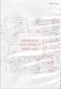
Map - BENDIGO GOLDFIELD MAP 1913, 1913
... BENDIGO GOLDFIELD MAP 1913......Goldfield map 1913...DVD. Bendigo Goldfield Map 1913....Bendigo Goldfield map 1913 DVD. Bendigo Goldfield Map 1913. ...DVD. Bendigo Goldfield Map 1913.bendigo, goldfield map 1913 -
 Bendigo Historical Society Inc.
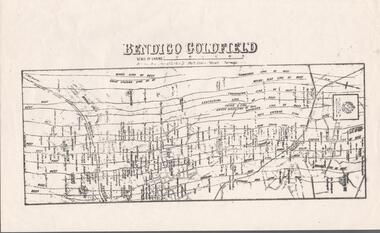
Map - BENDIGO GOLDFIELD MAP
... BENDIGO GOLDFIELD MAP......Bendigo Goldfield Map...Two not very clear copies of the Bendigo Goldfield Map. Streets, Railway Line, Lines of Reefs and mines are shown. ...History House 11 Mackenzie Street Bendigo goldfields MAP Bendigo goldfields Bendigo Goldfield Map Lines of Reefs Dept. of Mines Victoria Two not very clear copies of the Bendigo Goldfield Map. ...Two not very clear copies of the Bendigo Goldfield Map. Streets, Railway Line, Lines of Reefs and mines are shown. Dept. of Mines, Victoria printed on the map. Shows reefs from Bird's Line of Reefs to Lightning Hill Line of Reef.map, bendigo, goldfields, bendigo goldfield map, lines of reefs, dept. of mines victoria -
 Bendigo Historical Society Inc.
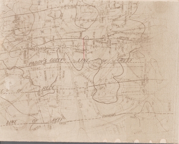
Map - GOLDFIELD MAP
... GOLDFIELD MAP......Goldfield Map...Portion of the map of the Bendigo Goldfield with the Paddy's Gully Line of Reef near the centre. ...History House 11 Mackenzie Street Bendigo goldfields MAP Bendigo goldfields Goldfield Map Paddy's Gully Line of Reef North Johnson Shaft Mine Shafts Portion of the map of the Bendigo Goldfield with the Paddy's Gully Line of Reef near the centre. ...Portion of the map of the Bendigo Goldfield with the Paddy's Gully Line of Reef near the centre. Streets, contours and gullies are included. Underlined in red is the North Johnson Shaft.map, bendigo, goldfields, goldfield map, paddy's gully line of reef, north johnson shaft, mine shafts -
 Bendigo Historical Society Inc.
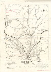
Document - JOAN O'SHEA COLLECTION: DUNNOLLY MAPS, 1980
... Joan O'Shea Collection. Goldfield Maps Dunolly 3 Sheets 1980. Page 1: Mines in Dunolly, Whistling Flat, Painswick and Surrounds. ...GoldField Maps 1980 based on Dunolly 7624 by Division of National Mapping...History House 11 Mackenzie Street Bendigo goldfields GOLD Goldfields goldfield maps dunolly & surrounds GoldField Maps 1980 based on Dunolly 7624 by Division of National Mapping Joan O'Shea Collection. ...Joan O'Shea Collection. Goldfield Maps Dunolly 3 Sheets 1980. Page 1: Mines in Dunolly, Whistling Flat, Painswick and Surrounds. Page 2: Mines in Goldsborough, McKinnons Gap, Bealiba Range, Stewarts Flat and Surrounds. Page 3: Mines in Dunolly, Emu Creek, Bet Bet, Bromley & Surrounds. Scale in Chains and Kilometres.GoldField Maps 1980 based on Dunolly 7624 by Division of National Mappinggold, goldfields, goldfield maps dunolly & surrounds -
 Bendigo Historical Society Inc.
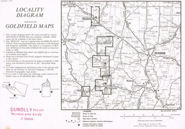
Document - JOAN O'SHEA COLLECTION: LOCALITY DIAGRAM AND NOTES FOR DUNNOLLY GOLDFIELD MAPS
... This locality diagram shows the areas covered by various goldfield maps. The Berlin field encompassed Rheola and parts of the Moliagul and Kingower goldfields. ...Locality diagram and notes for goldfield maps. Dunolly map set. Wedderburn, Berlin, Dunolly, Maryborough, Avoca....Locality diagram and notes for goldfield maps. Dunolly map set. Wedderburn, Berlin, Dunolly, Maryborough, Avoca. ...This locality diagram shows the areas covered by various goldfield maps. The Berlin field encompassed Rheola and parts of the Moliagul and Kingower goldfields. The name 'Berlin' is a corruption of Byrr Lyn, birthplace of Alexander Clelland who made an important strike in 1868.Joan O'Shea Collection. Locality diagram and notes for goldfield maps. Dunolly map set. Wedderburn, Berlin, Dunolly, Maryborough, Avoca.mining, company exploration, dunolly map set., berlin, kingower, wedderburn, gold mining -
 Tarnagulla History Archive
Photocopies of historic maps - Tarnagulla & surrounds, varied
... Includes Tarnagulla goldfields maps. ...Includes Tarnagulla goldfields maps. Photocopies of historic maps - Tarnagulla & surrounds Stokes & Son ...David Gordon Collection. 14 photocopies in clear sleeve. Includes Tarnagulla goldfields maps. -
Bendigo Historical Society Inc.
Map - GEOLOGICAL MAP BENDIGO GOLDFIELD, See above
... GEOLOGICAL MAP BENDIGO GOLDFIELD...map... Bendigo Goldfield...Map: Geological map of the Bendigo Goldfield comprising 2 sheets , Numbered 9358a and 9358b. ...History House 11 Mackenzie Street Bendigo goldfields MAP Bendigo geological Geological map Bendigo Goldfield Map: Geological map of the Bendigo Goldfield comprising 2 sheets , Numbered 9358a and 9358b. ...Map: Geological map of the Bendigo Goldfield comprising 2 sheets , Numbered 9358a and 9358b. Prepared in 1923 re-issued in 1936map, bendigo, geological, geological map, bendigo goldfield -
Bendigo Historical Society Inc.
Map - GOLDEN SQUARE GEOLOGICAL SURVEY, 1992
... Golden Square Geological Survey of Goldfields Coloured map....Golden Square Geological Survey of Goldfields Coloured map. Map GOLDEN SQUARE GEOLOGICAL SURVEY ...BHS CollectionGolden Square Geological Survey of Goldfields Coloured map.Dept of manufacturing and Industry Development.bendigo, gold mining, geological survey -
 Bendigo Historical Society Inc.
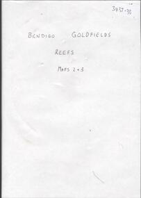
Map - BENDIGO GOLDFIELDS REEFS. MAPS 2 & 3
... DVD. Bendigo Goldfields Reefs, Maps 2 & 3....Bendigo Goldfields Reefs DVD. Bendigo Goldfields Reefs, Maps 2 & 3. Map BENDIGO GOLDFIELDS REEFS. ...DVD. Bendigo Goldfields Reefs, Maps 2 & 3.bendigo, goldfields reefs -
 Bendigo Historical Society Inc.
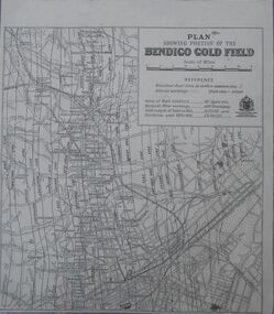
Map - Bendigo Gold Field
... Map...Goldfield...History House 11 Mackenzie Street Bendigo goldfields Map Goldfield Bendigo Plan showing portion of the Bendigo goldfield. ...Plan showing portion of the Bendigo goldfield. Area of main goldfield: 140 square miles. Deepest mine working: 4593' (Victoria quartz). Gold output of field to 1935: 20,775,000 ounces. Dividends paid 1870-1935: 10,740,000 pounds.map, goldfield, bendigo -
 Stawell Historical Society Inc
Photograph, Gold Fields Map Presentation to the Stawell Historical Society, 2001
... Three (3) Colour Photographs 1: SHS President Betty Jackson presented with goldfields map. by goldfoelds manager, Richard Carlton. 2: Mayor Karen Douglas, with Betty Jackson and Richard Carlton 3: Mayor Karen Douglas presenting colouring competition to School children...Stawell Three (3) Colour Photographs 1: SHS President Betty Jackson presented with goldfields map. by goldfoelds manager, Richard Carlton. 2: Mayor Karen Douglas, with Betty Jackson and Richard Carlton 3: Mayor Karen Douglas presenting colouring competition to School children Gold Fields Map Presentation to the Stawell Historical Society Photograph ...Gold Fields Map Presentation to SHS.Three (3) Colour Photographs 1: SHS President Betty Jackson presented with goldfields map. by goldfoelds manager, Richard Carlton. 2: Mayor Karen Douglas, with Betty Jackson and Richard Carlton 3: Mayor Karen Douglas presenting colouring competition to School childrenstawell -
 Bendigo Historical Society Inc.
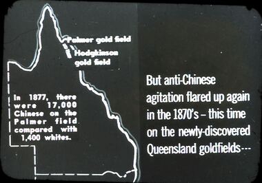
Slide - DIGGERS & MINING. THE CHINESE ON THE GOLD FIELDS, c1870s
... Slide: But anti-Chinese agitation flared up again in 1870's - this time on the newly-discovered Queensland goldfields . . . Map on left is of Queensland: Palmer Goldfield, Hodgkinson gold field. ...Slide: But anti-Chinese agitation flared up again in 1870's - this time on the newly-discovered Queensland goldfields . . . Map on left is of Queensland: Palmer Goldfield, Hodgkinson gold field. ...Diggers & Mining. The Chinese on the Gold Fields. Slide: But anti-Chinese agitation flared up again in 1870's - this time on the newly-discovered Queensland goldfields . . . Map on left is of Queensland: Palmer Goldfield, Hodgkinson gold field. In 1877, there were 17,000 Chinese on the Palmer field compared with 1,400 whites. Markings: 7. Used as a teaching aid.hanimounteducation, tertiary, goldfields -
 Bendigo Historical Society Inc.
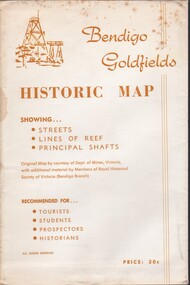
Document - BENDIGO GOLFIELDS HISTORIC MAP
... Bendigo goldfields historic map showing streets, lines of reef, principal shafts. ...History House 11 Mackenzie Street Bendigo goldfields Bendigo map goldfields mines tourism Bendigo goldfields historic map showing streets, lines of reef, principal shafts. ...Bendigo goldfields historic map showing streets, lines of reef, principal shafts. Original map (dept of Mines) with additional material by members of RHSV (Bendigo Branch) . Price 30c. Map; is folded into envelope for sale and storage.bendigo, map, goldfields, mines, tourism -
Bendigo Historical Society Inc.
Map - BENDIGO GOLDFIELD, No date visible
... MAP...Bendigo...mining plan...Bendigo Goldfield...Map: Bendigo Goldfield. Scale 20 chains to 1 inch. Printed by Cambridge Press, Bendigo. ...History House 11 Mackenzie Street Bendigo goldfields MAP Bendigo mining plan Bendigo Goldfield Gold Mines Mining Map: Bendigo Goldfield. ...Map: Bendigo Goldfield. Scale 20 chains to 1 inch. Printed by Cambridge Press, Bendigo. (number 318 in map cupboard 1)map, bendigo, mining plan, bendigo goldfield, gold mines, mining -
 Bendigo Historical Society Inc.
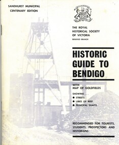
Book - HISTORIC GUIDE TO BENDIGO
... Historic Guide To Bendigo, Centenary 4th edition, 52 pages with maps of goldfields & showing streets, lines of reef & principal shafts.Produced by The Roayl Historical Society of Victoria Bendigo Branch, printed by Cambridge Press Bendigo with black and white photographs....History House 11 Mackenzie Street Bendigo goldfields BENDIGO History city history Historic Guide To Bendigo, Centenary 4th edition, 52 pages with maps of goldfields & showing streets, lines of reef & principal shafts.Produced by The Roayl Historical Society of Victoria Bendigo Branch, printed by Cambridge Press Bendigo with black and white photographs. ...Historic Guide To Bendigo, Centenary 4th edition, 52 pages with maps of goldfields & showing streets, lines of reef & principal shafts.Produced by The Roayl Historical Society of Victoria Bendigo Branch, printed by Cambridge Press Bendigo with black and white photographs.bendigo, history, city history -
 Bendigo Historical Society Inc.
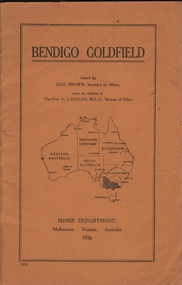
Book - BENDIGO GOLDFIELD
... Contains information on the geology of the Bendigo goldfield and major lines of reef and mines. Map of goldfield showing reef lines and mines attached to back cover....Contains information on the geology of the Bendigo goldfield and major lines of reef and mines. Map of goldfield showing reef lines and mines attached to back cover. ...booklet, 51 pages. 'Bendigo Goldfield' issued by Geo Brown, Secretary for Mines. Mines Department 1936. Contains information on the geology of the Bendigo goldfield and major lines of reef and mines. Map of goldfield showing reef lines and mines attached to back cover.bendigo, mining, bendigo goldfield -
 Bendigo Historical Society Inc.
Book - HISTORIC GUIDE TO BENDIGO
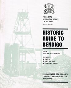
... Three books titled ' The Royal Historical Society of Victoria Bendigo Branch Historic Guide to Bendigo with map of goldfields showing streets, lines of reef, principal shafts. ...History House 11 Mackenzie Street Bendigo goldfields BENDIGO History gold mining book books Bendigo Bendigo history Victoria Victorian history Australian history gold gold fields The Royal Historical Society of Victoria gold discoveries Three books titled ' The Royal Historical Society of Victoria Bendigo Branch Historic Guide to Bendigo with map of goldfields showing streets, lines of reef, principal shafts. ...Three books titled ' The Royal Historical Society of Victoria Bendigo Branch Historic Guide to Bendigo with map of goldfields showing streets, lines of reef, principal shafts. Recommended for tourists, students, prospectors and historicans.' Sixth Edition. Cambridge Press, Bendigo. Maps, photos, diagrams.bendigo, history, gold mining, book, books, bendigo, bendigo history, victoria, victorian history, australian history, gold, gold fields, the royal historical society of victoria, gold discoveries -
 Bendigo Historical Society Inc.
Book - HISTORIC GUIDE TO BENDIGO
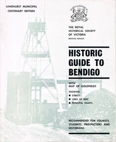
... A copy of a book titled 'The Royal Historical Society of Victoria Bendigo Branch Historic Guide to Bendigo with map of goldfields showing streets, lines of reef, principal shafts. ...History House 11 Mackenzie Street Bendigo goldfields BENDIGO History gold mining book books Bendigo Bendigo history history Australian history Victoria Victorian history goldfields gold The Royal Historical Society of Victoria A copy of a book titled 'The Royal Historical Society of Victoria Bendigo Branch Historic Guide to Bendigo with map of goldfields showing streets, lines of reef, principal shafts. ...A copy of a book titled 'The Royal Historical Society of Victoria Bendigo Branch Historic Guide to Bendigo with map of goldfields showing streets, lines of reef, principal shafts. Recommended for tourists, students, prospectors and historians.' Sandhurst Municipal Centenary Edition. 4th edition. Maps, photos, illustrations.bendigo, history, gold mining, book, books, bendigo, bendigo history, history, australian history, victoria, victorian history, goldfields, gold, the royal historical society of victoria -
 Bendigo Historical Society Inc.
Book - HISTORIC GUIDE TO BENDIGO
... Five copies of ' The Royal Historical Society of Victoria Bendigo Branch Historic Guide to Bendigo with map of goldfields showing streets, lines of reef, principal shafts. ...History House 11 Mackenzie Street Bendigo goldfields BENDIGO History gold mining book books Bendigo Bendigo history history Victorian history Victoria Australian history gold fields gold gold discoveries The Royal Historical Society of Victoria Five copies of ' The Royal Historical Society of Victoria Bendigo Branch Historic Guide to Bendigo with map of goldfields showing streets, lines of reef, principal shafts. ...Five copies of ' The Royal Historical Society of Victoria Bendigo Branch Historic Guide to Bendigo with map of goldfields showing streets, lines of reef, principal shafts. Recommended for tourists, students, prospectors and historians.' Cambridge Press, Bendigo. Third Edition. Maps, photos, illustratons. Only four copies have maps.bendigo, history, gold mining, book, books, bendigo, bendigo history, history, victorian history, victoria, australian history, gold fields, gold, gold discoveries, the royal historical society of victoria -
 Bendigo Historical Society Inc.
Slide - DIGGERS & MINING. GETTING THE GOLD, c1860
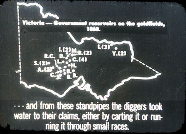
... Slide: Map of Victoria. Victoria - Government reservoirs on the goldfields, 1860. ...Victoria - Government reservoirs on the goldfields, 1860. Letters on map relate to the position of the reservoirs standpipes. ...Diggers & Mining. Getting the Gold. Slide: Map of Victoria. Victoria - Government reservoirs on the goldfields, 1860. Letters on map relate to the position of the reservoirs standpipes. And from these standpipes the diggers took water to their claims, either by carting it or running it through small races. Markings: 72 994.LIF:4. Used as a teaching aid.hanimounteducation, tertiary, goldfields -
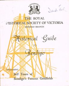 Bendigo Historical Society Inc.
Book - HISTORICAL GUIDE TO BENDIGO
... Including Self Tours of Bendigo's Famous Goldfields' .Cambridge Press, Bendigo.' maps, photos, illustrations. ...Including Self Tours of Bendigo's Famous Goldfields' .Cambridge Press, Bendigo.' maps, photos, illustrations. ...Five copies of ' The Royal Historical Society of Victoria Bendigo Branch Historical Guide to Bendigo. Including Self Tours of Bendigo's Famous Goldfields' .Cambridge Press, Bendigo.' maps, photos, illustrations. Three copies do not contain maps, however, these three copies have number stickers on the bott left front ccover, 0064.2 PAR, 0064.3 PAR, 0064.4 PAR.bendigo, history, gold mining, book, books, bendigo, bendigo history, history, gold mining, mines, the royal historical society of victoria bendigo branch, victoria, goldfields, victorian history, australian history -
 Bendigo Historical Society Inc.
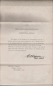
Document - REPORT ON THE BENDIGO GOLDFIELD, EDWARD DYASON
... Grey cover document, 21 typed pages with map of goldfield appended. On front page 'Report on the Bendigo Goldfield Central Area. ...History House 11 Mackenzie Street Bendigo goldfields BENDIGO Gold mining report on goldfield Bendigo goldfield goldmining mining companies reef lines underground workings E.C. Dyason Grey cover document, 21 typed pages with map of goldfield appended. ...Grey cover document, 21 typed pages with map of goldfield appended. On front page 'Report on the Bendigo Goldfield Central Area. This report is the outcome of an investigation into the present condition and future prospects of the Central Area of the Bendigo goldfield, undertaken with a view to seeing what improved methods could be adopted in the conduct of mining operations to neutralise the recent heavy increase in the cost of labour and mining requisites, and so restore the industry to the level of its previous prosperity' Signed by E.C. Dyason, B.Sc. B.M.E., Commonwealth Chambers, Bendigo, Victoria, 15th November, 1918.bendigo, gold mining, report on goldfield, bendigo goldfield, goldmining, mining companies, reef lines, underground workings, e.c. dyason -
 Warrnambool and District Historical Society Inc.
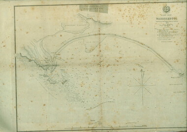
Document, Map: Lady Bay 1853, 1853
... This map is of high historical and comparitive significance as it shows the Lady Bay area prior to the changes that have occurred in the last 160 years with the building of the breakwater. The issue regarding access to Lady Bay remains a current one. The engraver D Tulloch engraved some of the earliest scenes of the goldfields ...This is one of the earliest surveys and maps of Warrnambool harbor, Lady Bay. Being done in 1853, it shows the depths of the bay area marked in fathoms, currents and directions and areas of rocks around mouth of the Merri and the Western side of the bay as well as a large sand spit to the middle right of the beach region.. It also marks the large areas of seaweed and fuci in the outer bay area. It has the area of Pertobe Lagoon marked and shows the early tracks to the town. The engraving work was done by Tulloch and Brown, with Tulloch being one of the earliest engravers and lithographers in the state of Victoria. He arrived in Melbourne in 1849 and set up business with James Davie Brown in 1853 with Brown being a map engraver. They were awarded bronze and silver medals for their work at the Victorian Industrial Exhibition. He also worked in the vignettes on the Proeschel Map of Victoria.This map is of high historical and comparitive significance as it shows the Lady Bay area prior to the changes that have occurred in the last 160 years with the building of the breakwater. The issue regarding access to Lady Bay remains a current one. The engraver D Tulloch engraved some of the earliest scenes of the goldfields in Ballarat and as such has left a record of a very early and important era in Australian history. Rectangular cream paper with black text. Map area is outlined by fine black lined border. Key in top right hand corner and scale at bottom middle of map.Map is labelled Town of Warrnambool printed at top of map. Small logo at top right corner which has “Hydrographic Department” in circle around an anchor. Lady Bay Warrnambool Surveyed by John Barrow assistant surveyor Engraved by Tulloch & Brown in bottom right corner. Melbourne engraved by order of the legislative Council of Victoria in middle bottom.map, warrnambool, town of warrnambool map 1853, tulloch & brown map 1853, lady bay warrnambool,, warrnambool harbour, warrnambool breakwater, warrnambool beach -
 Bendigo Military Museum
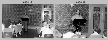
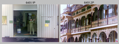
Photograph - Army Survey Regiment Open Day - Briefings and Tours, Fortuna, Bendigo, 1990
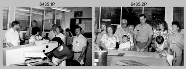
... goldfields These 27 photographs were taken at an Army Survey Regiment Open Day at Fortuna Villa, Bendigo on the 24th of February 1990. This occasion was one of several events held to commemorate the 75th anniversary of the formation of the Royal Australian Survey Corps. Although historical tours of Fortuna occurred on a regular basis, this was the first technical open day since 1972. The Royal Australian Survey Corps recognised that an Open Day was the best way for the local community in Bendigo to gain an insight into the unit’s important role as Defence’s map ...These 27 photographs were taken at an Army Survey Regiment Open Day at Fortuna Villa, Bendigo on the 24th of February 1990. This occasion was one of several events held to commemorate the 75th anniversary of the formation of the Royal Australian Survey Corps. Although historical tours of Fortuna occurred on a regular basis, this was the first technical open day since 1972. The Royal Australian Survey Corps recognised that an Open Day was the best way for the local community in Bendigo to gain an insight into the unit’s important role as Defence’s map production agency, its technical equipment, and its economic importance to Bendigo. It also gave them an opportunity to tour through historic Fortuna Villa. This occasion is covered in more detail in page 143 of Valerie Lovejoy’s book 'Mapmakers of Fortuna – A history of the Army Survey Regiment’ ISBN: 0-646-42120-4. Refer to items 6435.35P and 6436.18P for more photos of the Open Day taken in the Map Production areas of Air Survey and Cartographic Squadron, and production areas of Lithographic Squadron. Photo prints of some of these photos were scanned and catalogued in items 6247.30P and 6291.6P.These 27 photographs were taken at an Army Survey Regiment Open Day held at Fortuna, Bendigo on the 24th of February 1990. The 35mm colour and black & white negatives photographs were scanned at 96 dpi and are part of the Army Survey Regiment’s Collection. .1) & .2) - Photo, black & white, 1990. Ballroom - Visitor briefings by CO LTCOL Rene van den Tol. .3) - Photo, colour, 1990. Ballroom - Visitor briefings by MAJ Ray Redman. .4) - Photo, colour, 1990. Ballroom - Visitor briefings by unidentified UK Exchange officer. .5) - Photo, black & white, 1990. Music Room - Visitor briefings by MAJ Bob Williams. .6) - Photo, black & white, 1990. Orderly Room - ADJT CAPT Peter Parkes. .7) - Photo, colour, 1990. Music Room - ADJT CAPT Peter Parkes with civilian visitors. .8) - Photo, colour, 1990. Music Room - Visitor briefings by CPL Le-Anne (Smallshaw) Shirley. .9) - Photo, colour, 1990. Entrance Foyer - Visitor briefings. .10) - Photo, colour, 1990. CO’s Office - Visitor briefings by CPL Raelene (Munting) Brodie. .11) - Photo, colour, 1990. Mr Pat Thwaites outlining utilisation of satellite imagery to civilian visitors. .12) - Photo, black & white, 1990. Mr Pat Thwaites outlining utilisation of satellite imagery to civilian visitors. .13) - Photo, colour, 1990. Staircase leading up to the top floor - Visitor briefings by CPL Ian Nelson. .14) - Photo, colour, 1990. Building 16 - Visitor briefings by RSM WO1 Neville Stone. .15) - Photo, colour, 1990. Civilian visitors enjoying views of the garden from Fortuna Villa’s rooftop. .16) - Photo, black & white, 1990. Visitor briefings at Fortuna’s rear steps. .17) - Photo, black & white, 1990. Outside Building 16 - Visitor briefings by WO1 Gary Warnest. .18) - Photo, colour, 1990. Outside Building 16 - Visitor briefings by WO2 Adrian ‘Charlie’ Creedy. .19) - Photo, colour, 1990. Outside Building 16 - L to R: SPR Sue (Foote) Bourne, LCPL Sandy Winn, WO2 Adrian ‘Charlie’ Creedy. .20) - Photo, colour, 1990. Outside Building 16 - SGT Greg Byers. .21) - Photo, colour, 1990. Visitors enjoying Devonshire Tea in the gardens next to the Tavern. .22) - Photo, colour, 1990. RSM WO1 Neville Stone and family enjoying Devonshire Tea in the gardens next to the Tavern. .23) - Photo, colour, 1990. Visitors relaxing in the garden next to Fortuna’s lake. .24) - Photo, black & white, 1990. CPL Trevor Poll and others serve up BBQ lunch next to the tennis courts. .25) to .27) - Photo, colour, 1990. Parking at a premium inside the Army Survey Regiment and Chum Street..1P to .27P – no annotationsroyal australian survey corps, rasvy, army survey regiment, army svy regt, fortuna, asr -
 Bendigo Military Museum
Photograph - Army Survey Regiment Open Day - Map Production, Fortuna, Bendigo, 1990
... goldfields These 35 photographs were taken at an Army Survey Regiment Open Day at Fortuna Villa, Bendigo on the 24th of February 1990. This occasion was one of several events held to commemorate the 75th anniversary of the formation of the Royal Australian Survey Corps. Although historical tours of Fortuna occurred on a regular basis, this was the first technical open day since 1972. The Royal Australian Survey Corps recognised that an Open Day was the best way for the local community in Bendigo to gain an insight into the unit’s important role as Defence’s map ...These 35 photographs were taken at an Army Survey Regiment Open Day at Fortuna Villa, Bendigo on the 24th of February 1990. This occasion was one of several events held to commemorate the 75th anniversary of the formation of the Royal Australian Survey Corps. Although historical tours of Fortuna occurred on a regular basis, this was the first technical open day since 1972. The Royal Australian Survey Corps recognised that an Open Day was the best way for the local community in Bendigo to gain an insight into the unit’s important role as Defence’s map production agency, its technical equipment, and its economic importance to Bendigo. It also gave them an opportunity to tour through historic Fortuna Villa. This occasion is covered in more detail in page 143 of Valerie Lovejoy’s book 'Mapmakers of Fortuna – A history of the Army Survey Regiment’ ISBN: 0-646-42120-4. Refer to items 6434.27P and 6436.18P for more photos of the Open Day taken inside Fortuna, the garden areas and production areas of Lithographic Squadron. Photo prints of some of these photos were scanned and catalogued in items 6247.30P and 6291.6P.These 35 photographs were taken at an Army Survey Regiment Open Day held at Fortuna, Bendigo on the 24th of February 1990. The 35mm colour and black & white negatives photographs were scanned at 96 dpi and are part of the Army Survey Regiment’s Collection. .1) - Photo, black & white, 1990. CPL Neale ‘Tex’ Houston with visitors in Aerotriangulation Section. .2) - Photo, black & white, 1990. L to R: MAJ Peter Clark and WO2 Neil ‘Ned’ Kelly with visitors in Aerotriangulation Section. .3) - Photo, black & white, 1990. SGT Bruce Hammond with visitors in Aerotriangulation Section. .4) - Photo, colour, 1990. SGT Bruce Hammond with visitors in Aerotriangulation Section. .5) - Photo, colour, 1990. SGT Steve Gloster with visitors in Aerotriangulation Section. .6) - Photo, colour, 1990. L to R: CPL Noel Brinsmead and CPL Darren Wilkinson with visitors in Aerotriangulation Section. .7) - Photo, colour, 1990. L to R: CPL Noel Brinsmead with visitors in Aerotriangulation Section. .8) - Photo, colour, 1990. MAJ Peter Clark with visitors in Aerotriangulation Section. .9) - Photo, colour, 1990. CPL Mark Lander with visitors in Plotting Section. .10) - Photo, colour, 1990. SSGT Andy Boath with visitors in Plotting Section. .11) - Photo, colour, 1990. SPR Stuart Bowd with visitors in Plotting Section. .12) - Photo, colour, 1990. CAPT Roger Hancock with visitors in Plotting Section. .13) & .14) - Photo, colour, 1990. AUTOMAP 2 - CPL Peter Peterson with visitors. .15) - Photo, colour, 1990, AUTOMAP 2 - L to R: SSGT Graham Johnston, SPR Grant Davis with civilian visitors. .16) - Photo, colour, 1990, AUTOMAP 2 - L to R: CPL Steve McGuiness, SSGT Graham Johnston with civilian visitors. .17) - Photo, colour, 1990, AUTOMAP 2 - civilian visitors. .19) - Photo, colour, 1990, AUTOMAP 2 - L to R: unidentified, SPR Tony Jackson, CPL Mark Westbrook, SSGT Bob Bright, with civilian visitors. .20) - Photo, colour, 1990, AUTOMAP 2 - L to R: WO2 Adrian ‘Charlie’ Creedy, CPL Mark Westbrook, SPR Mick Duggan with civilian visitors. .21) - Photo, colour, 1990, AUTOMAP 2 - L to R: SPR Mick Duggan, CO LTCOM Rene van den Tol, SSGT Bob Bright, CPL Mark Westbrook with civilian visitors. .22) - Photo, colour, 1990, AUTOMAP 2 - L to R: SPR Damien Nolan, unidentified, SPR Peter Smyth with civilian visitors. .23) - Photo, black & white, 1990, AUTOMAP 2 - L to R: SPR Peter Smyth, CAPT Steve Hledik, SGT Martin Evans, MAJ Neil Taylor with civilian visitors. .24) - Photo, black & white, 1990, AUTOMAP 2 - L to R: SPR Mick Duggan, CPL Mark Westbrook with civilian visitors. .25) - Photo, black & white, 1990, AUTOMAP 2 – LCPL Sandy Winn with civilian visitor. .26) - Photo, black & white, 1990. Display of digital storage media. .27) & .28) - Photo, colour, 1990. Cartography - SPR Ian Baldwin with civilian visitors. .29) - Photo, black & white, 1990. Cartography - SPR Ian Baldwin with civilian visitors. .30) - Photo, black & white, 1990. Cartography - SGT Sherri (Dally) Burke with civilian visitors. .31) - Photo, colour, 1990. Cartography - L to R: SGT Sherri (Dally) Burke, SSGT Dennis Learmonth with civilian visitors. .32) - Photo, colour, 1990. Cartography – SGT Barry Hogan with civilian visitors. .33) & .34) - Photo, colour, 1990. Cartography – CPL Dan Cirsky with civilian visitors. .35) - Photo, colour, 1990. Cartography – L to R: SPR Jeanette (Lane) Dury-Lane, CPL Diane (Thomas) Soutar with civilian visitors..1P to .35P – no annotationsroyal australian survey corps, rasvy, army survey regiment, army svy regt, fortuna, asr, automap 2 -
 Bendigo Military Museum
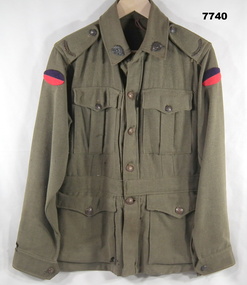
Uniform - JACKET, BATTLE DRESS - ARMY, Australian Defence Industries, 1942
... goldfields Uniform Army Battle Dress WW2 Manufacturers information on two labels. Black ink print - "REGIMENTAL NO./NAME" Red ink print - "V162/ MADE IN/ AUSTRALIA/ 1942/ size". Handwritten black ink pen "XXX/ 20X" Jacket - Khaki colour wool serge fabric. Battle Dress style with belt at waist. Brown metal buttons with shank and split pin. Buttons have raised emblem - map ...Jacket - Khaki colour wool serge fabric. Battle Dress style with belt at waist. Brown metal buttons with shank and split pin. Buttons have raised emblem - map of Australa and Crown and lettering "AUSTRALIAN MILITARY FORCES". Collar, shoulder epaulettes, four front pockets with button down flaps, sleeve cuffs. Unit colour patch insignia - handmade purple over red - 38th Battalion. Collar badges - metal - Rising Sun Badge. Shoulder epaulettes - metal "AUSTRALIA" badge. Manufacturers white cotton fabric label - inside right pocket.Manufacturers information on two labels. Black ink print - "REGIMENTAL NO./NAME" Red ink print - "V162/ MADE IN/ AUSTRALIA/ 1942/ size". Handwritten black ink pen "XXX/ 20X" uniform, army, battle dress, ww2 -
 Bendigo Military Museum
Photograph - Army Survey Regiment Open Day – Lithographic Squadron, Fortuna, Bendigo, 1990
... goldfields These 18 photographs were taken at an Army Survey Regiment Open Day at Fortuna Villa, Bendigo on the 24th of February 1990. This occasion was one of several events held to commemorate the 75th anniversary of the formation of the Royal Australian Survey Corps. Although historical tours of Fortuna occurred on a regular basis, this was the first technical open day since 1972. The Royal Australian Survey Corps recognised that an Open Day was the best way for the local community in Bendigo to gain an insight into the unit’s important role as Defence’s map ...These 18 photographs were taken at an Army Survey Regiment Open Day at Fortuna Villa, Bendigo on the 24th of February 1990. This occasion was one of several events held to commemorate the 75th anniversary of the formation of the Royal Australian Survey Corps. Although historical tours of Fortuna occurred on a regular basis, this was the first technical open day since 1972. The Royal Australian Survey Corps recognised that an Open Day was the best way for the local community in Bendigo to gain an insight into the unit’s important role as Defence’s map production agency, its technical equipment, and its economic importance to Bendigo. It also gave them an opportunity to tour through historic Fortuna Villa. This occasion is covered in more detail in page 143 of Valerie Lovejoy’s book 'Mapmakers of Fortuna – A history of the Army Survey Regiment’ ISBN: 0-646-42120-4. Refer to items 6434.27P and 6435.35P for more photos of the Open Day taken inside Fortuna, the garden areas and Map Production areas of Air Survey and Cartographic Squadron. Photo prints of some of these photos were scanned and catalogued in items 6247.30P and 6291.6P.These 18 photographs were taken at an Army Survey Regiment Open Day held at Fortuna, Bendigo on the 24th of February 1990. The 35mm colour and black & white negatives photographs were scanned at 96 dpi and are part of the Army Survey Regiment’s Collection. .1) - Photo, colour, 1990. Print Troop – WO2 Rob Bogumil with visitors. .2) - Photo, colour, 1990. Print Troop – L to R: SPR Ross Anza, LCPL Janet Murray with visitors. .3) - Photo, black & white, 1990. Print Troop – L to R: LCPL Janet Murray, MAJ Bob Coote, SPR Gary Lord with visitors. .4) - Photo, black & white, 1990. Photo Troop – L to R: WO2 Keith Fenton RE UK Exchange, SGT Steve Burke with visitors. .5) - Photo, colour, 1990. Photo Troop – SGT Steve Burke with visitors. .6) - Photo, colour, 1990. Photo Troop – L to R: unidentified, SGT Steve Burke with visitors. .7) - Photo, colour, 1990. Print Troop – L to R: CPL Peter Breukel, WO2 Keith Fenton RE. UK Exchange with visitors. .8) - Photo, black & white, 1990. Photo Troop - WO2 Keith Fenton RE. UK Exchange. .9) - Photo, black & white, 1990. Print Troop - civilian visitors. .10) - black & white, Print Troop, 1990. - L to R: civilian visitors, SSGT Ian Nichols, CPL John ‘Flash’ Anderson. .11) - Photo, black & white, 1990. Print Troop - L to R: SSGT Ian Nichols, CPL Dale Hudson, Planeta printing press, with civilian visitors. .12) - Photo, colour, 1990. Print Troop - L to R: SSGT Ian Nichols, CAPT Roger Hancock with civilian visitors. .13) - Photo, colour, 1990. Print Troop - LT Marty Lyons with civilian visitors. .14) - Photo, black & white, 1990. Print Troop - L to R: LT Marty Lyons, unidentified with civilian visitors. .15) - Photo, black & white, 1990. Orthophoto Mapping Section - L to R: SSGT Peter Imeson, SGT Bob Garritty with civilian visitors. .16) - Photo, colour, 1990. Optronics raster scanner - WO2 Adrian ‘Charlie’ Creedy with civilian visitors. .17) - Photo, colour 1990. Outside Photo Troop office - L to R: SSGT Rhys De Laine, WO2 Rob Bogumil. .18) - Photo, black & white, 1990. Photo Troop - civilian visitors..1P to .18P – no annotationsroyal australian survey corps, rasvy, army survey regiment, army svy regt, fortuna, asr, litho sqn -
 Bendigo Military Museum
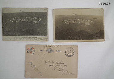
Postcard - POSTCARD - HURDCOTT, AIF CAMP, UK, R. H. Baron, 3. 3/11/1918
... goldfields Cards relate to R.H. Baron's time at Hurdcott AIF Camp during 1918. Part of the "Robert H. Baron", No. 3596, and Cooper Collection. See Catalogue No. 1981P for details of Baron's service. Robert H. Baron Cooper Collection Postcards Hurdcott AIF Camp 1. Handwritten in black ink on back: 'This map ...Cards relate to R.H. Baron's time at Hurdcott AIF Camp during 1918. Part of the "Robert H. Baron", No. 3596, and Cooper Collection. See Catalogue No. 1981P for details of Baron's service.1. Black and white newspaper clipping pasted onto a piece of cream card. Clipping features a black and white photograph of a map of Australia carved into the side of a hill. Caption in black type below photograph. 2. Black and white postcard style photograph of a map of Australia carved into the side of a hill. 3. Plain cream coloured postcard with YMCA logo and AIF insignia at the top. Handwritten address on front and handwritten letter on back.1. Handwritten in black ink on back: 'This map has been cut in the hill and is only about 10 minutes walk from here, Bob' 3. Handwritten in black ink on front: 'Miss M. Baron, 208 Forest St. Bendigo, Victoria, Australia'. Stamped in black on top R.H.C. of front: 'Postmark - AIF Camp P.O. No.4, 18,' Handwritten in black ink on back: 'Letter to R.H. Baron's sister Myrtle from Hurdcott Camp dated 3.11.18.'robert h. baron, cooper collection, postcards, hurdcott aif camp -
 Bendigo Military Museum
Photograph - KLIMSCH Large Format Camera and Wild OR1 Orthorectification Equipment - Army Survey Regiment, Fortuna, Bendigo, c1986
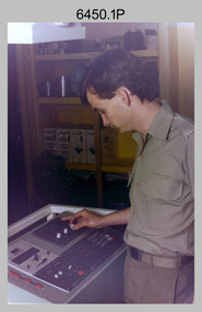
... Bendigo Military Museum 37 - 39 Pall Mall Bendigo goldfields The main tasks undertaken by technicians operating the KLIMSCH Commodore large format camera were enlargements and reductions of map reproduction material. seen in photo .1P is at the operating console. ...The main tasks undertaken by technicians operating the KLIMSCH Commodore large format camera were enlargements and reductions of map reproduction material. seen in photo .1P is at the operating console. See item 6189.4P for more information and photos of CPL Whaling operating the KLIMSCH camera. Orthophoto mapping provided the Survey Corps with the capability to produce map products quickly in the event of a crisis. These are four photographs of equipment used by the Army Survey Regiment to produce orthophotomaps. The WILD OR1 orthophoto projector and workstation shown in photos .3P and .4P was introduced in the mid-1980s. It was the second-generation equipment used to orthorectify colour and monochrome film aerial photography, replacing the system introduced in 1973. See items 6124.5P and 6133.4P for more photographs of orthorectification equipment.These four photographs of KLIMSCH large format camera and Wild OR1 orthorectification equipment was taken at the Army Survey Regiment at Fortuna, Bendigo, c1986. The colour photographs are on 35mm negative film and scanned at 96 dpi. They are part of the Army Survey Regiment’s Collection. .1) - Photo, colour, c1986, CPL John Whaling operating the KLIMSCH Camera. .2) - Photo, colour, c1986, large format film developer. .3) - Photo, colour, c1986, WILD OR-1 Orthorectification Workstation operated by CPL Dave Jobe. .4) - Photo, colour, c1986, WILD OR-1 Orthorectification Workstation..1P to .4P – There are no annotations.royal australian survey corps, rasvy, army survey regiment, army svy regt, fortuna, asr -
 Bendigo Military Museum
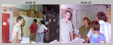
Photograph - Lithographic Squadron Personnel and Equipment, Army Survey Regiment, Fortuna, Bendigo, c1990
... Bendigo Military Museum 37 - 39 Pall Mall Bendigo goldfields These 28 photographs of Lithographic Squadron personnel and equipment was taken at Fortuna, Bendigo circa 1990. The photos were taken on the east side of Fortuna Villa, the Print Room’s map trimming and dispatch work area and the inside and outside Air Survey Support Section (BARCRO). ...These 28 photographs of Lithographic Squadron personnel and equipment was taken at Fortuna, Bendigo circa 1990. The photos were taken on the east side of Fortuna Villa, the Print Room’s map trimming and dispatch work area and the inside and outside Air Survey Support Section (BARCRO).These 28 photographs of Lithographic Squadron Personnel and Equipment was taken at Fortuna, Bendigo circa 1990. The 35mm colour photograph negatives were scanned at 96 dpi and are part of the Army Survey Regiment’s Collection. .1) - Photo, colour, c1990. RAEME and maintenance support, unidentified civilian. .2) - Photo, colour, c1990. Eastern side of Fortuna Villa, unidentified, CPL Le-Anne (Smallshaw) Shirley. .3) - Photo, colour, c1990. Eastern side of Fortuna Villa, SGT Gary Kerr. .4) - Photo, colour, c1990. Eastern side of Fortuna Villa, CPL Roy Hicks. .5) - Photo, colour, c1990. Eastern side of Fortuna Villa, unidentified. .6) - Photo, colour, c1990. Unidentified passing Q-Store & Transport Compound. .7) - Photo, colour, c1990. Data Management & Map Library. .8) - Photo, colour, c1990. Unidentified officer passing Q-Store heading up to Map Library. .9) - Photo, colour, c1990. Eastern side of Fortuna Villa, SPR Michelle Withers. .10) - Photo, colour, c1990. Unidentified RAEME soldier passing Q-Store heading up to Map Library. .11) & .12) - Photo, colour, c1990. Delivery of bulk map printing paper. WO2 Jeff Willey on forklift, unidentified. .13) & .14) - Photo, colour, c1990. Print Room, Wohlenberg MCS-2 guillotine. .15) to .18) - Photo, colour, c1990. Air Survey Support Section (BARCRO), Carl Zeiss Rectifying Enlarger. .19) - Photo, colour, c1990. Air Survey Support Section (BARCRO), film contact frame. .20) - Photo, colour, c1990. Air Survey Support Section (BARCRO), Pakotone film development processors. .21) & .22) - Photo, colour, c1990. Air Survey Support Section (BARCRO) entry/exit. .23) & .24) - Photo, colour, c1990. Air Survey Support Section (BARCRO) miscellaneous equipment. .25) & .26) - Photo, colour, c1990. Air Survey Support Section (BARCRO), CPL Warren ‘Waldo’ Shirley. .27) & .28) - Photo, colour, c1990. Outside Air Survey Support Section (BARCRO), L to R: WO1 Peter Coombes, CPL Warren ‘Waldo’ Shirley..1P to .28P – There are no annotations.royal australian survey corps, rasvy, army survey regiment, army svy regt, fortuna, asr, litho sqn