
Showing 17 items matching "government land auctions"
-
 Federation University Historical Collection
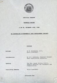
Document - Documents, Tourello: Opening of Tourello Bridge; Tourello Hunt Club, 1909; Tourello Tennis Club; Government Land Auction, 1855
... Tourello: Opening of Tourello Bridge; Tourello Hunt Club, 1909; Tourello Tennis Club; Government Land Auction, 1855......government land auctions...tourello bridge hunt club tennis club government land auctions talbot clunes coghill lenaghan peter lalor R. ...Maps and typed documentstourello bridge, hunt club, tennis club, government land auctions, talbot, clunes, coghill, lenaghan, peter lalor, r. kinnersly, d.t. anderson, ralph willis, creswick -
 Federation University Historical Collection
Poster - Signs, Window signs by Keith Rash
... Government Land Sale, Mr C.N. Thorne purchased this area. In 1893, R. Ludbrook used this property as Auction Rooms. .3) McArtney & aldred first occupied these premises in 1856. ...Government Land Sale, Mr C.N. Thorne purchased this area. In 1893, R. Ludbrook used this property as Auction Rooms. .3) McArtney & aldred first occupied these premises in 1856. ...It is thought the signs were used for Ballarat's Gold Centenary in 1851.Seven window signs by Keith Rash painted onto wallpaper. The signs were designed to sit in shop windows to tell the history of the shop of company. .1) In 1862 Eurgene Bourdet conducted the "Imperial Dining Rooms" here. Board 20/- Board & Lodging 25/- week .2) On 16th Feb. 1853 at the Government Land Sale, Mr C.N. Thorne purchased this area. In 1893, R. Ludbrook used this property as Auction Rooms. .3) McArtney & aldred first occupied these premises in 1856. There were coachbuilders. .4) From the Single Storeyed wooden building once her J.P. Clarke operated as a carrier until 1865. Welsh & Surplice took over as Estate Agents until 1870. .5) Dr James Stewart built this property H.G. Harrison, 1957. J.C. Proctor 1862, John Stokes 1865, were chemists here. In 1856 The Savings Bank commenced here. W.H. Pooley, actuary .6) Wm Moss, tinsmith, occupied this site in 1865. Thos. Freeman,a uctioneer in 1882. .7) Doig & Cant. Gasfitters & Plumbers came here from Main Road in 1866. After 38 years A. Cant removed 2 doors further north .8) In 1871, This part was the shop of Wm Moss, tinsmith & plumberballarat, doig, cant, plumber, william moss, tinsmith, thomas freeman, james stewart, h.g. harrison, j.c. proctor, john stokes, savings bank, w.h. pooley, j.p. clarke, welsh, surplice, mcartney, aldred, coachbuilders, c.n. thorne, r. ludbrook, eugene bourdet -
 The Beechworth Burke Museum
Photograph - Lantern Slide, c1900
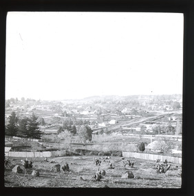
... Government in 1855 to make land available for sale for farming purposes as an alternative occupation and income for people who wished to stay in the region but move away from gold mining. A secondary motivation was to increase the supply of fresh produce and decrease prices of items that otherwise needed to be transported from Melbourne or other regions. Forty-three country lots were initially offered in the Three Mile area, ranging in size from two to ninety acres and costing from £1 to £3 per acre. An additional eighty-five country lots were auctioned...Government in 1855 to make land available for sale for farming purposes as an alternative occupation and income for people who wished to stay in the region but move away from gold mining. A secondary motivation was to increase the supply of fresh produce and decrease prices of items that otherwise needed to be transported from Melbourne or other regions. Forty-three country lots were initially offered in the Three Mile area, ranging in size from two to ninety acres and costing from £1 to £3 per acre. An additional eighty-five country lots were auctioned ...Miners from Snake Valley lobbied the Victorian Government in 1855 to make land available for sale for farming purposes as an alternative occupation and income for people who wished to stay in the region but move away from gold mining. A secondary motivation was to increase the supply of fresh produce and decrease prices of items that otherwise needed to be transported from Melbourne or other regions. Forty-three country lots were initially offered in the Three Mile area, ranging in size from two to ninety acres and costing from £1 to £3 per acre. An additional eighty-five country lots were auctioned later in the year, in addition to many smaller suburban lots. More lots were offered than sold, initially, but this represented conditions of sale requiring the total purchase cost up front which many people interested in purchasing could not afford, especially as land purchased for farming would accrue substantial additional costs for clearing and labour before becoming productive. Further lobbying activities and the election of parliamentary members sympathetic to the cause took place through the 1850s. Ovens Parliamentary Member, Daniel Cameron, was re-elected in 1856 on a platform of surveying the land for public selection with deferred payment options. Land reform remained an issue in the area through the 1850s and early 1860s, impacting broader decisions in the new State of Victoria relating to voting rights, use of Crown land and the farming of land that wasn't always suitable for the purpose. This photograph depicts Beechworth in approximately 1900, after several waves of land sales resulted in increasingly levels of development. Lantern slides, sometimes called 'magic lantern' slides, are glass plates on which an image has been secured for the purpose of projection. Glass slides were etched or hand-painted for this purpose from the Eighteenth Century but the process became more popular and accessible to the public with the development of photographic-emulsion slides used with a 'Magic Lantern' device in the mid-Nineteenth Century. Photographic lantern slides comprise a double-negative emulsion layer (forming a positive image) between thin glass plates that are bound together. A number of processes existed to form and bind the emulsion layer to the base plate, including the albumen, wet plate collodion, gelatine dry plate and woodburytype techniques. Lantern slides and magic lantern technologies are seen as foundational precursors to the development of modern photography and film-making techniques.This glass slide is significant because it provides insight into Beechworth's built environment and infrastructure in the early Twentieth Century, around the time of Australia's Federation. It is also an example of an early photographic and film-making technology in use in regional Victoria in the time period.Thin translucent sheet of glass with a square-edged image printed on the front and framed in a black backing. It is held together by metal strips to secure the edges of the slide.burke museum, beechworth, lantern slide, slide, glass slide, plate, burke museum collection, photograph, monochrome, indigo shire, north-east victoria, farming, squatters, miners, agriculture, land-clearing, land reform, daniel cameron, land sales, three mile, snake valley, tarrawingee -
 Federation University Historical Collection
Photograph - Colour, Chatham-Holmes Collection: Trawalla Estate, Victoria - Soldier Settlement
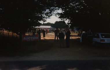
... Government for the Soldier Settlement Scheme. Land was subdivided into 93 allotments with sizes from 250 acres to 680 acres. The land was deemed appropriate for grazing and farming. chatham-holmes collection soldier settlement langi kal kal auction philip chatham trawalla Chatham-Holmes Collection: Trawalla Estate, Victoria - Soldier Settlement Photograph - Colour ...In 1917 a large part of the Trawalla estate was acquired and subdivided by the Commonwealth Government for the Soldier Settlement Scheme. Land was subdivided into 93 allotments with sizes from 250 acres to 680 acres. The land was deemed appropriate for grazing and farming.chatham-holmes collection, soldier settlement, langi kal kal, auction, philip chatham, trawalla -
Port Melbourne Historical & Preservation Society
Document - Notice, Auction, Crown Lands, 1892
... town planning land sales Auction notice of Crown lands, 1892 Document Notice, Auction, Crown Lands Victorian Government Government Printer ...Auction notice of Crown lands, 1892town planning, land sales -
Eltham District Historical Society Inc
Document - Folder, Panton, Joseph Anderson
... land once held by Joseph Anderson Panton. Newspaper article: "Historic painting might be lost to Victoria," The Age, 22 October 1985. Painting by Joseph Anderson Panton of Captain William Lonsdale's house, Victoria's first Government House, to be in forthcoming auction. ...land once held by Joseph Anderson Panton. Newspaper article: "Historic painting might be lost to Victoria," The Age, 22 October 1985. Painting by Joseph Anderson Panton of Captain William Lonsdale's house, Victoria's first Government House, to be in forthcoming auction. ...Joseph Anderson Panton (1831-1913) came from Scotland to Australia in 1851. In Bendigo, he was appointed assistant gold commissioner 1852 and senior commissioner 1854. Over the years, he served as magistrate at Jamieson-Wood's Point, Anderson's Creek, Heidelberg, Geelong and Melbourne. He owned land on the Yarra River and Panton Hill is named for him. Contents Map: J A Panton's landholding with surrounding landholders. Printout and photocopy: Panton, Joseph Anderson, Australian Dictionary of Biography entry. Notes: Joseph Anderson Panton, brief biographical notes. Research Enquiry Form: Vivienne Worthington, seeking sources of information regarding Joseph Anderson Panton, 14 June 2017. Email and associated documents: Michael Kennedy seeking assistance of Eltham Gateway Action Group regarding proposed felling of manna gum tree near bridge across Diamond Creek, on land once held by Joseph Anderson Panton. Newspaper article: "Historic painting might be lost to Victoria," The Age, 22 October 1985. Painting by Joseph Anderson Panton of Captain William Lonsdale's house, Victoria's first Government House, to be in forthcoming auction. Newspaper clippings, A4 photocopies, etcjoseph anderson panton, william b burnley, w walsh, r hall, r a davidson, j orford, b speers, a speers, william bell, t baillie, d mcloughlin, t prior, g e hodgkins, n rodda, w r belcher, g d boursiquot, j p imley, t b darling, h g jones, t sweny, r lane, w gordon, a e morris, d w thring, j carfrae, thomas sweeney, michael kennedy, vivienne worthington, william crozier, j frank, p carrucan, panton hill -
Whitehorse Historical Society Inc.
Newspaper, Land Auction, 29/04/1992 12:00:00 AM
... middlefield primary school auctions primary schools The Site of the former Middlefield Primary School is to be Auctioned on 12th May, 1992, The Site of the former Middlefield Primary School is to be Auctioned on 12th May, 1992, by Barry Plant. State Government agreed to 22% Public Open Space. Land ...The Site of the former Middlefield Primary School is to be Auctioned on 12th May, 1992,The Site of the former Middlefield Primary School is to be Auctioned on 12th May, 1992, by Barry Plant. State Government agreed to 22% Public Open Space.The Site of the former Middlefield Primary School is to be Auctioned on 12th May, 1992,middlefield primary school, auctions, primary schools -
 Kew Historical Society Inc
Plan - Subdivision Plan, Oswinia Estate, East Kew, c.1925
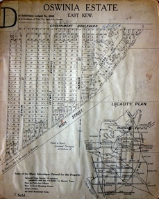
... The ‘Oswinia Estate’ subdivision in East Kew was planned and auctioned in the first half of the 1920s. 169 allotments were created in the triangular section of land bordered by High Street, Burke Road and the Government Boulevard (later Kilby Road). ...These photographs provide significant heritage information relating house design and decoration, fencing and household gardens. subdivision plans - east kew oswinia estate high street, glass street, namur street, government boulevard - kilby road, irymple street, oswin street The ‘Oswinia Estate’ subdivision in East Kew was planned and auctioned in the first half of the 1920s. 169 allotments were created in the triangular section of land bordered by High Street, Burke Road and the Government Boulevard (later Kilby Road). ...Prue Sanderson, in her groundbreaking ‘City of Kew Urban Conservation Study : Volume 2 - Development History’ (1988), summarised the periods of urban development and subdivisions of land in Kew. The periods that she identified included 1845-1880, 1880-1893, 1893-1921, 1921-1933, 1933-1943, and Post-War Development. These periods were selected as they represented periods of rapid growth or decline in urban development. An obvious starting point for Sanderson’s groupings involved population growth and the associated economic cycles. These cycles also highlighted urban expansion onto land that was predominantly rural, although in other cases it represented the decline and breakup of large estates. A number of the plans in the Kew Historical Society’s collection can also be found in other collections, such as those of the State Library of Victoria and the Boroondara Library Service. A number are however unique to the collection.Subdivision plans are historically important documents used as evidence of the growth of suburbs in Australia. They frequently provide information about when the land was sold on which a built structure was subsequently constructed as well as evidence relating to surveyors and real estate and financial agents. The numerous subdivision plans in the Kew Historical Society's collection represent working documents, ranging from the initial sketches made in planning a subdivision to printed plans on which auctioneers or agents listed the prices for which individual lots were sold. In a number of cases, the reverse of a subdivision plan in the collection includes a photograph of a house that was also for sale by the agent. These photographs provide significant heritage information relating house design and decoration, fencing and household gardens.The ‘Oswinia Estate’ subdivision in East Kew was planned and auctioned in the first half of the 1920s. 169 allotments were created in the triangular section of land bordered by High Street, Burke Road and the Government Boulevard (later Kilby Road). The only piece of land excluded was that where the previous Kew Pound had been located at the east tip of the triangle. Allotments were created fronting Glass, High, Namur, Oswin Streets, Irymple Avenue, and the Government Boulevard. The name for the Estate was derived from Oswin’s farm, which had been one of the largest landholdings in East Kew. The selling agents annotated the plan in our collection with crosses indicating those lots that had been sold. The inset locality plan is particularly interesting as it shows the route and stations of the Outer Circle Railway. When the subdivision plan was created, it included the proposed bridge over the Yarra at Burke Road. The bridge was to be officially opened in 1926.subdivision plans - east kew, oswinia estate, high street, glass street, namur street, government boulevard - kilby road, irymple street, oswin street -
![Map, Liquidator's sale, 1896. [Woolpack Estate, Bacchus Marsh]](/media/collectors/5e461d8021ea67224c82f2a1/items/6779ee97032b72846b5995f2/item-media/6779ef33032b72846b599b30/item-fit-380x285.jpg?cb=6) Bacchus Marsh & District Historical Society
Bacchus Marsh & District Historical SocietyMap, Liquidator's sale, 1896. [Woolpack Estate, Bacchus Marsh]
... land in the Bacchus Marsh Valley, and other properties". The auction was conducted by the local agents W. Anderson and Bence in conjunction with Pearce Brothers also of Bacchus Marsh. Land Sales Bacchus Marsh Bacchus Marsh Victoria Maps Woolpack Estate Bacchus Marsh Victoria A single page paper map showing a plan of 150 acres of land from the Woolpack Estate to be sold in various lots in June 1896. Also shown on the map are lots for sale at Robinson's Farm on Coimadai Creek and allotments near Bacchus Marsh railway station, including lots on Government ...The Woolpack Estate was an area of land owned by various landowners in the Bacchus Marsh area since the early Colonial period of the 1840s. The area was located on the eastern side of the Bacchus Marsh township about 7 kilometers from the town. The Lerderderg River ran through part of the land and so did the Melbourne to Ballarat Road. The historic Woolpack Inn associated with James Crook was also located on this land. By 1896 150 acres of this land was under the control of liquidators for the Federal Bank of Australasia who instructed that the land be sub-divided and sold in lots by public auction. A successful sale was held on 24 June 1896. Most of the blocks of land were sold for higher than expected prices and most of the buyers were people from the town and district of Bacchus Marsh. The map includes various details about the land which is described on the map as an "important sale of rich alluvial irrigable flat land in the Bacchus Marsh Valley, and other properties". The auction was conducted by the local agents W. Anderson and Bence in conjunction with Pearce Brothers also of Bacchus Marsh.A single page paper map showing a plan of 150 acres of land from the Woolpack Estate to be sold in various lots in June 1896. Also shown on the map are lots for sale at Robinson's Farm on Coimadai Creek and allotments near Bacchus Marsh railway station, including lots on Government Road (East Maddingley Road), View Street and Government Road (Parwan Road). No scale provided. The map is pasted into a bound volume containing 76 maps or plans in total. High resolution digital image stored on BMDHS computer network. land sales bacchus marsh, bacchus marsh victoria maps, woolpack estate bacchus marsh victoria -
 Wodonga & District Historical Society Inc
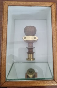
Functional object - Seal - Police Office, Belvoir
... The first sale of land in Belvoir was held at Wangaratta on April 28, 1854, when all the allotments surveyed by Thomas Wedge (excepting those set apart for reserves, government and public areas) were offered at auction. ...The first sale of land in Belvoir was held at Wangaratta on April 28, 1854, when all the allotments surveyed by Thomas Wedge (excepting those set apart for reserves, government and public areas) were offered at auction. ...This seal was used for official police and court documents by the Belvoir Police Office.The initial land survey for the city now known as Wodonga was first undertaken in 1852 by Thomas Wedge - Assistant Surveyor. The new township was called "Belvoir" and was proclaimed by that name in 1852 and again in 1861. The first sale of land in Belvoir was held at Wangaratta on April 28, 1854, when all the allotments surveyed by Thomas Wedge (excepting those set apart for reserves, government and public areas) were offered at auction. Following representations by the Postmaster General on June 23, 1869, the Governor in Council, on July 12, 1869, approved of its Aboriginal name "Wodonga" being restored. The seal was found at the Yackandandah Courthouse by the Circuit Judge, the late Mr. Jim Humphrey. As the Wodonga Historical Society was in recess at that time, the seal was held in trust by the North-East Historical Society in Wangaratta. It was donated to the Wodonga Historical Society in 1987.This item was the official seal of the Belvoir Police office from the beginning of the European settlement of the modern day city of Wodonga, then known as Belvoir. It is one of the earliest relics of that period of history, until its name was changed in 1869.Wood and metal seal bearing the official emblem of the Police Office Belvoir. It would have been used to apply a wax seal to official documents. The seal is mounted in a timber and glass case so that the imprint of the seal can be seen reflected in a mirror mounted in the base of the box.Around the edges of the seal "POLICE OFFICE / BELVOIR"belvoir police, official seal, history wodonga -
 City of Greater Bendigo - Civic Collection
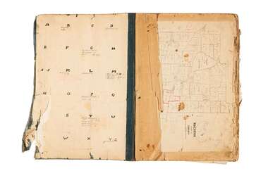
Administrative record - Land Sales, A. J. Mullet Government Printer et al, 1927
... auctioning and selling land. City of Bendigo Commerce Large portfolio style album with dark green / black cloth cover bound with three large metal pins. Forty eight pages with twenty seven Department of Lands and Survey maps and newspaper clippings about land sales and auction details pasted in. Index page. Maps have handwritten notes and markings throughout in pencil and pen. Covers the County's of Gunbower and Tatchera. Includes a receipt slip with hand written notes on reverse on William Wallace & Co letterhead. Administrative record Land Sales A. J. Mullet Government ...This type of album was made by agents auctioning and selling land.Large portfolio style album with dark green / black cloth cover bound with three large metal pins. Forty eight pages with twenty seven Department of Lands and Survey maps and newspaper clippings about land sales and auction details pasted in. Index page. Maps have handwritten notes and markings throughout in pencil and pen. Covers the County's of Gunbower and Tatchera. Includes a receipt slip with hand written notes on reverse on William Wallace & Co letterhead. city of bendigo commerce -
 City of Greater Bendigo - Civic Collection
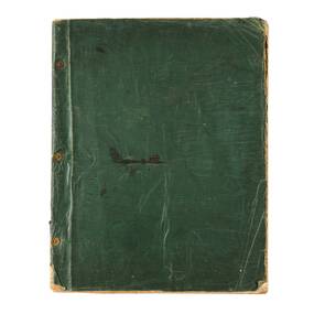
Administrative record - Land Sales, Department of Lands and Survey et al, 1929
... auctioning and selling land. Large portfolio style album with green cloth cover bound with three large metal pins. One hundred and then pages with thirty three Department of Lands and Survey maps pasted in. Index page. Maps have handwritten notes and markings throughout in pencil and pen. Covers the Counties of Bendigo, Rodney, Talbot, Gunbower, Gladstone, Tatchera and Karkarooc, Shires of East Loddon and Huntly and Swan Hill District. Administrative record Land Sales Department of Lands and Survey A. J. Mullet Government ...This type of album was created by agents auctioning and selling land.Large portfolio style album with green cloth cover bound with three large metal pins. One hundred and then pages with thirty three Department of Lands and Survey maps pasted in. Index page. Maps have handwritten notes and markings throughout in pencil and pen. Covers the Counties of Bendigo, Rodney, Talbot, Gunbower, Gladstone, Tatchera and Karkarooc, Shires of East Loddon and Huntly and Swan Hill District. -
 City of Greater Bendigo - Civic Collection
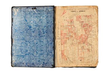
Administrative record - Land Sales, A. J. Mullet Government Printer, 1927
... auctioning and selling land. City of Bendigo Commerce Large portfolio style album with black cloth cover bound with three large metal pins. Blue marbled pastedown endpapers. Seventy nine pages, seventy five with Department of Lands and Survey maps attached. No index page. Maps have handwritten notes and markings throughout in pencil and pen. Covers the Counties of Bendigo, Rodney, Gladstone and Talbot and Parishes of Kerang, Salisbury, Mandurang and Tarnagulla. Includes a hand written note on William Wallace & Co letterhead. Administrative record Land Sales A. J. Mullet Government ...This type of album was created by agents auctioning and selling land.Large portfolio style album with black cloth cover bound with three large metal pins. Blue marbled pastedown endpapers. Seventy nine pages, seventy five with Department of Lands and Survey maps attached. No index page. Maps have handwritten notes and markings throughout in pencil and pen. Covers the Counties of Bendigo, Rodney, Gladstone and Talbot and Parishes of Kerang, Salisbury, Mandurang and Tarnagulla. Includes a hand written note on William Wallace & Co letterhead. city of bendigo commerce -
Ringwood and District Historical Society
Legal record - Real Estate & Stock Institute of Victoria Contract of Sale (C.E.Carter of Ringwood - Agent), Vendor: Florence L. COOMBES. Purchaser: Robert Musgrave EVANS - October, 1944
... government consent for the sale. The contract is prepared on the standard Real Estate and Stock Institute of Victoria form and executed through agent C.E. Carter. The accompanying conditions outline obligations under wartime National Security Regulations, including requirements for Treasurer’s consent and purchaser declarations regarding enemy alien restrictions. If consent is refused, the contract becomes void and money is refunded; if consent is granted at a reduced price, the vendor may accept or terminate. Additional clauses cover possession upon acceptance of title, equal sharing of the valuer’s fee, and standard 1936 copyright conditions relating to land tax, default, instalments, and auction...government consent for the sale. The contract is prepared on the standard Real Estate and Stock Institute of Victoria form and executed through agent C.E. Carter. The accompanying conditions outline obligations under wartime National Security Regulations, including requirements for Treasurer’s consent and purchaser declarations regarding enemy alien restrictions. If consent is refused, the contract becomes void and money is refunded; if consent is granted at a reduced price, the vendor may accept or terminate. Additional clauses cover possession upon acceptance of title, equal sharing of the valuer’s fee, and standard 1936 copyright conditions relating to land tax, default, instalments, and auction ...Copy of contract and covering typewritten summary. Property in Arlington Street, Ringwood - Part of Crown Portion 6, Parish of Ringwood, Certificate of Title Volume 4927, Folio 985626.AI Summary using CoPilot (16/9/2026): The document is a 1944 contract of sale between Florence L. Coombes (vendor) and Robert Musgrave Evans (purchaser) for a parcel of land in Arlington Street, Ringwood, described as part of Crown Portion 6, Parish of Ringwood, Certificate of Title Volume 4927 Folio 985626. The land measures 60 feet by 180 feet, and the agreed purchase price is £165, with a £10 deposit payable on signing and the balance due within 30 days of receiving government consent for the sale. The contract is prepared on the standard Real Estate and Stock Institute of Victoria form and executed through agent C.E. Carter. The accompanying conditions outline obligations under wartime National Security Regulations, including requirements for Treasurer’s consent and purchaser declarations regarding enemy alien restrictions. If consent is refused, the contract becomes void and money is refunded; if consent is granted at a reduced price, the vendor may accept or terminate. Additional clauses cover possession upon acceptance of title, equal sharing of the valuer’s fee, and standard 1936 copyright conditions relating to land tax, default, instalments, and auction rules. The purchaser also agrees to sign an acknowledgment under the Farmers’ Debts Adjustment Act 1935. -
Ringwood and District Historical Society
Legal record - Real Estate & Stock Institute of Victoria Contract of Sale (C.E.Carter of Ringwood - Agent), Vendor: Josephine CROWTHER. Purchaser: Keith Raymond BARRAH - September, 1947
... The contract incorporates the 1946 Copyright Conditions of Sale, including provisions relating to land tax, default, instalments, auction rules, and wartime National Security Regulations requiring government consent for transfers. ...The contract incorporates the 1946 Copyright Conditions of Sale, including provisions relating to land tax, default, instalments, auction rules, and wartime National Security Regulations requiring government consent for transfers. ...Copy of contract with sundry correspondence and covering typewritten summary. Property - Lot 7, Plan of Subdivision 9413, Part of Crown Allotment 130, Parish of Nunawading, Certificate of Title Volume 5495, Folio 1098994.AI Summary using CoPilot (16/9/2026): The documentation records a 1947 contract of sale between Josephine Crowther (vendor) and Keith Raymond Barrah (purchaser) for Lot 7 on Plan of Subdivision 9413, part of Crown Allotment 130 in the Parish of Nunawading, County of Bourke. The land is described in Certificate of Title Volume 5495 Folio 1098994. The agreed purchase price was £66/5/-, with a £7 deposit payable on signing and the balance due within 30 days of receiving Commonwealth Treasurer’s consent. The contract was prepared and executed through C.E. Carter & Son, Estate Agents, Ringwood. The purchaser is described as a “Cadet Artist”, and the vendor’s address is listed as “21 Linton Street, St Kilda.” The contract incorporates the 1946 Copyright Conditions of Sale, including provisions relating to land tax, default, instalments, auction rules, and wartime National Security Regulations requiring government consent for transfers. The accompanying correspondence shows the administrative steps surrounding the sale. Letters between Carter & Son, the purchaser’s solicitor J. Robertson Macmillan, and the vendor confirm the signing of the contract, submission of Form 7, and later receipt of the Treasurer’s consent. A valuation fee of £2/2/- was charged for the required government valuation, with the valuer’s fee shared between vendor and purchaser. A later account to Mrs Crowther explains an additional £1/1/- deduction relating to a separate valuation: “Although the sale fell through we still had to pay for the valuation. We recovered half from the purchaser and the other half was recovered from you.” The file concludes with receipts and account statements documenting the deposit, commission, and valuation charges. -
Ringwood and District Historical Society
Document - Real Estate & Stock Institute of Victoria Contract of Sale (C.E.Carter of Ringwood - Agent), Unsigned draft auction contract. Vendor: Annie Jane INGLIS - 1938
... auction contract of sale of land with Agent's typewritten summary. Properties include Lots 4, 9, 15, 20, 11, 12, 13, 16, 17 and 18, Plan of Subdivision of Crown Portion 1, Parish of Ringwood, County of Bourke. Lot location reference points include a Government...land described comprises multiple allotments within the Parish of Ringwood, County of Bourke, forming a substantial holding across Portions of Portion No. 1. The schedule details Allotments 4 and 9, 15 and 20, and 11, 12, 13, 16, 17 and 18, bounded variously by Orwell Street, Chester Street, Belgrave Road, and a Government Road. These allotments are defined by precise bearings and distances, forming three contiguous sections of land within early subdivisions surveyed by Nelson Polak. Unsigned draft auction ...Unsigned draft auction contract of sale of land with Agent's typewritten summary. Properties include Lots 4, 9, 15, 20, 11, 12, 13, 16, 17 and 18, Plan of Subdivision of Crown Portion 1, Parish of Ringwood, County of Bourke. Lot location reference points include a Government Road, Orwell Street, Chester Street and Belgrave Road, Ringwood.18666 Inglis AI Summary This unsigned 1938 draft contract records the proposed sale of land by Annie Jane Inglis, widow of High Street, Kew, with C. E. Carter of Ringwood acting as agent. The purchase price is left blank, but the terms specify a £50 deposit and payment of the balance within 30 days without interest. The vendor sells as mortgagee, and the purchaser is to accept the title commencing from conveyances dated 1882 and 1907. Special conditions remove certain statutory conditions, require acceptance of measurements without objection, and provide possession or rental entitlement upon full payment. The land described comprises multiple allotments within the Parish of Ringwood, County of Bourke, forming a substantial holding across Portions of Portion No. 1. The schedule details Allotments 4 and 9, 15 and 20, and 11, 12, 13, 16, 17 and 18, bounded variously by Orwell Street, Chester Street, Belgrave Road, and a Government Road. These allotments are defined by precise bearings and distances, forming three contiguous sections of land within early subdivisions surveyed by Nelson Polak. -
Ringwood and District Historical Society
Document - Real Estate & Stock Institute of Victoria Contract of Sale (C.E.Carter of Ringwood - Agent), Unsigned draft auction contract. Vendor: Ada L. Kennedy of Warrandyte Road, Ringwood - March, 1931
... 18667 Kennedy AI Summary The document is an unsigned draft auction contract dated 28 March 1931 for the sale of Lot 3 on Plan of Subdivision 9648, part of Crown Portion 5 and part of a former government road in the Parish of Ringwood. The land...18667 Kennedy AI Summary The document is an unsigned draft auction contract dated 28 March 1931 for the sale of Lot 3 on Plan of Subdivision 9648, part of Crown Portion 5 and part of a former government road in the Parish of Ringwood. The land ...Unsigned draft auction contract of sale of land with Agent's typewritten summary. Property - Lot 3 on Plan of Subdivision 9648, Part of Crown Portion 5, Parish of Ringwood, Certificate of Title Volume 4902 Folio 980219.18667 Kennedy AI Summary The document is an unsigned draft auction contract dated 28 March 1931 for the sale of Lot 3 on Plan of Subdivision 9648, part of Crown Portion 5 and part of a former government road in the Parish of Ringwood. The land is described as having a frontage of “58 feet 6 inches to Whitehorse Road by a depth of 131 feet 5 inches on the west side and 131 feet 9 inches on the east side…” and includes all buildings and erections on the property. Ada L. Kennedy is listed as vendor, with the purchaser’s details and the purchase price left blank. The contract was prepared for auction by C.E. Carter of Ringwood. The terms require a £150 deposit, with the balance payable by weekly instalments of 25 shillings at 7% interest until 28 March 1936, after which the remaining balance becomes due. The purchaser may pay off the whole or part of the purchase money early. The property is sold subject to existing tenancies and easements, and the purchaser must insure the buildings while instalments remain unpaid. Numerous technical amendments appear throughout the pro forma document, indicating it is a working draft.
