Showing 390 items matching grampians ranges
-
 Halls Gap & Grampians Historical Society
Photograph - B/W
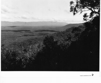
... Grampians Ranges... Grampians Ranges ...Photo is of Victoria Valley with the Victoria Range in the background. Photo is typical of promotional photographs taken by Forests Commission at that time.a thick bush covered valley in foreground (shadowed). Mountain range in background. Photographed from a high spot looking down and across the valley. c1960sscenery, grampians ranges -
 Stawell Historical Society Inc
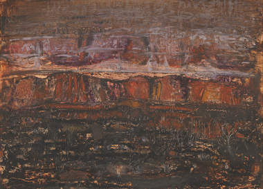
Painting, Will Rees, "Evening Shadows" of Stawell Victoria Aug, 1929
... Framed painting of field trees and Grampians Range... painting of field trees and Grampians Range in background. Houses ...Framed painting of field trees and Grampians Range in background. Houses in distance and what may be a smokestack. 1929To Robert Rees Morcom on his 21st Birthday May 1934. From his Grandfather Will Rees and aunt Elsie Rees. -
Warrnambool and District Historical Society Inc.
Sheet Music, My Grampian Rose, 1940s
... situated close to the Grampians mountain range and the title... having a multi-coloured illustration of the Grampians mountain... of the Grampians mountain range in Victoria. It is in good condition ...This is a waltz piece of music with words and music by Ruby Wharrie. Mrs Wharrie is best known for her doll-making business which she operated in Stawell, Victoria with her husband and son. Mrs Wharrie was the designer of the dolls which were made in the 1940s and 50s. One doll was named ‘Shurl’ to cash in on the popularity of the child actress Shirley Temple and the consequent popularity of the Shirley Temple doll. Stawell is a provincial city situated close to the Grampians mountain range and the title of the music reflects Mrs Wharrie’s interest in the area. ‘My Grampian rose’ is a person and the theme of the music is the fulfilment of love - ‘I am coming back to you, my little Grampian Rose’. This music is of interest as it has been written by a person who lived in western Victoria. It has Ruby Wharrie’s signature inside the front cover, making it more valuable. It is also an example of the sweet and sentimental music produced during the 1940s and 50s as a foil to the sadness and brutality of the world war. This is sheet music of four pages (two pages printed back to back) with the printed music on three pages and the cover having a multi-coloured illustration of the Grampians mountain range in Victoria. It is in good condition and has an old catalogue number ‘94’ on the back page. Front cover: ‘My Grampian Rose, Words and Music by Ruby Wharrie, 2/6’ Inside front cover: ‘Ruby Wharrie’ ruby wharrie, my grampian rose -
 Stawell Historical Society Inc
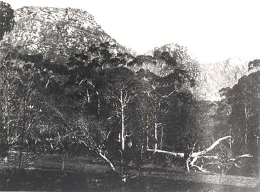
Photograph, Wonderland Range in the Grampians 1866
... Grampians (Wonderland Range). Part of a collection... grampians Photograph Wonderland Range in the Grampians 1866 ...Grampians (Wonderland Range). Part of a collection of Photographs by Mr. O.G. Armstrong as commissioned by the Shire of Stawell for the Inter-colonial and Paris Exhibition in Melbourne in 1866.stawell -
Stawell Historical Society Inc
Book - Report, Grampians National Park Draft Management Plan, 1985
... Soft Cover with B/W Photo of aerial view of ranges... Soft Cover with B/W Photo of aerial view of ranges of Grampians ...For Public comment to National Park Service, Victoria. A Division of the department of Conservation, Forest and LandsSoft Cover with B/W Photo of aerial view of ranges of Grampians. Black taped Spine binding.$5 Barry Clugston -
Stawell Historical Society Inc
Photograph, Aerial Photos of Stawell from a Hot Air Balloon 1992 -- 12 Photos
... Street 5. Florence Street towards Cato Lake & Park 6. Grampians... Street towards Cato Lake & Park 6. Grampians Range with Lake ...Series of 12 Aerial Photos of Stawell. Hot Air Balloon 1992 1. Cnr Maude St & Grant Street 2. Maude St Napier Street & Railway cutting 3. Trotting Track 4. Roundabout Wimmera & Sloane Street 5. Florence Street towards Cato Lake & Park 6. Grampians Range with Lake Lonsdale near center 7. Gold Reef Mall looking West 8. Church Street looking West 9. Looking towards Black Range 10. Moonie Dams Darlington Road Leisure Complex 11. Stawell Gold Mine Evaporations Dams, Stawell Water Reservoirs, Moonie Dams 12. Darlington Road looking towards Black RangeColour photographs from Airstawell -
Stawell Historical Society Inc
Map, Plan of Division Line between Ararat and Stawell Shires 1877, 1877
... Grampians Halls Gap Black Range Stawell Shire Ararat Shire... 28.12.77 Grampians Halls Gap Black Range Stawell Shire Ararat Shire ...Grampians Halls Gap Black Range Stawell Shire Ararat Shire Crowlands TownshipVery Large Map Printed on Linen with Table of bearingsExamined by H.C. Malcolm 28.12.77 Traced By D.H. Meike 28.12.77survey -
 Stawell Historical Society Inc
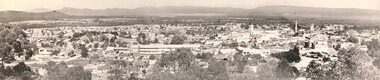
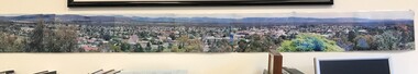
Photograph, Panorama of Stawell from Big Hill c 1966
... prominent in photo. Grampians and Black Range in background. Visible... technical school prominent in photo. Grampians and Black Range ...1966 Panorama from Big Hill. New technical school prominent in photo. Grampians and Black Range in background. Visible are St Patrick's Church, Kinsella, Nalders Garage, Town Hall, St Matthews, Upper Main Street. Trees in foreground.Panorama of Stawell from Big Hill in 1966Magnificent View of Stawell from Big Hill c 1966stawell, education, panorama, streetscape -
 Stawell Historical Society Inc
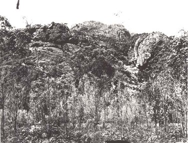
Photograph, Wonderland Range in the Grampians at Halls Gap 1866
... Grampians Halls Gap (Wonderland Range). Part... grampians Photograph Wonderland Range in the Grampians at Halls Gap ...Grampians Halls Gap (Wonderland Range). Part of a collection of Photographs by Mr. O.G. Armstrong as commissioned by the Shire of Stawell for the Inter-colonial and Paris Exhibition in Melbourne in 1866.stawell -
 Stawell Historical Society Inc
Photograph, Panorama of Stawell from Big Hill c 1998 -- Coloured
... . Black Range and Grampians visible in background. Panorama photo... grampians Photograph Panorama of Stawell from Big Hill c 1998 ...Colour Panorama of Stawell c 1998 Overlooking Stawell. Black Range and Grampians visible in background. Panorama photo was taken by Irene Read for Barbara Bennet, a member of the "Big Hill Action Group" The group were fighting Stawell Gold Mines proposal to "Open Pit" the Big Hill area. SGM was at that time owned by an American Company - Pitston-Brinks. Laminated panorama of Stawell from Big Hill c 1998 -- Coloured photographs producing a panorama of Stawell. stawell, panorama -
 The WAMA Project : The National Centre for Environmental Art
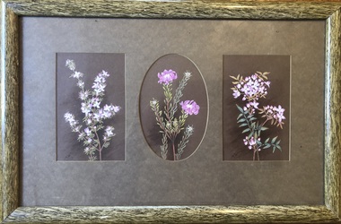
Painting, Marianne Wehl (1867 - 1926), Untitled (Boronia pilosa, Pultenaea subalpina, Boronia latipinna), c1887 to 1924
... found on the higher peaks of the central Grampians ranges... found on the higher peaks of the central Grampians ranges ...The artist: Marianne Louise Charlotte Amalie Wehl (19 Sept. 1867, Mt Gambier; 26 Oct. 1926, Melbourne), a flower painter who was active in South Australia and Victoria, and not to be confused with Marie Magdalene Wehl. Connection with Baron von Mueller: Von Mueller’s younger sister, Clara married Doctor Eduard Wehl and they lived in South Australia. They had 14 children, 6 of whom collected and painted botanical studies – some now in the National Herbarium, Melbourne. A cousin of Doctor Wehl – Carl Wehl – married Sophia Caroline (née Gorte) and one of their daughters was Marianne Wehl. It is recorded that von Mueller visited the Wehls and D’Altons in Halls Gap (Henrietta D'Alton was also a painter of wildflowers), so it is hard to believe that there is no influence at least. Von Mueller had over 1,400 collectors/artists working for him and 225 of them were women and children. Their work is housed in the National Herbarium, Melbourne. The donor believes that Marianne contributed to this work. There is no record of that, however, as only 169 of the artists have been identified, it may be a possibility. Marianne was one of six children of Carl Jakob Wilhelm Wehl (1830–1899) and Sophia Caroline Wehl (née Gorte) (1843–1920). She never married. https://data.environment.sa.gov.au/Content/Publications/JABG34P001_Dowe.pdf The plants: All of the plants painted by Marianne Wehl's in this donation were identified by Botanist Neil Marriott & Wendy Marriott, in July 2022. Neil Marriott said that the quality and beauty of these botanical studies made it easy for them to identify all the plants. He suggested they may be some of the first paintings of Grampians wildflowers. This makes the paintings highly important scientifically and botanically. Visitors to WAMA will be able to compare them with today’s plants in the Endemic Garden. Neil marvelled that Marianne found the specimens, as some of them are endemic and found only in the highest parts of the Grampians (Mt Rosea, Mt William and Major Mitchell Plateau) and are listed as rare and endangered. Some of these same rare plants have now been propagated by the WAMA team and in winter 2022 were planted in WAMA's Endemic Garden. This framed work is considered by him to be the most significant botanically. Boronia pilosa – Hairy boronia. [Wikipedia says it’s a plant in the citrus family Rutaceae and is endemic to south-eastern Australia MH] Pultenaea subalpina - Rosy Bush-pea. Grampians endemic listed as endangered and only found on the tops of Mt William, Major Mitchell Plateau and Mt Rosea - named for the Rosy Bush-pea that grows on its top! This is the only rose-coloured bush pea in the entire genus, which occurs right across Australia!! We have plants ready to plant in the WAMA endemic garden! Boronia latipinna - Grampians Boronia. Grampians endemic only found on the higher peaks of the central Grampians ranges - listed endangered. NB In some records she is called Marianna (as the donor calls her) and in others Marianne. Wildflower art, Wildlife art, wildflowers, Marianne Wehl, Marianna Wehl, Flower paint, Botany, works on paper, von Mueller, Baron von Mueller, Ferdinand von Mueller, Henrietta D'Alton, WAM, Wild Art Museum Australia, Wildlife Art Museum AustraliaGift of Barbara Crick in memory of Marjorie and Lachlan McLennanThree small paintings of pink wildflowers mounted together in original frame. The central image is an oval, flanked by two rectangular images. The frame is probably original – smooth gloss olive green simulating wood or bamboo. It has a new backing paper.Each image LL ' MW' (underlined), central image has signature obscured by oval vignetted matt. On the reverse side it is marked in black felt pen, “McLennan 106 Bennet Rd (4)” This refers to preparation (rematting / framing?) for exhibiting at Horsham Art Gallery in 1981.wildflowers, flowers -
 Flagstaff Hill Maritime Museum and Village
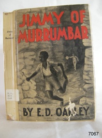
Book, Jimmy of Murrumbar, circa 1938
... and mountain region of the Grampian Ranges of Victoria. Oakely's... of the Grampian Ranges of Victoria. Oakely's parents, Thomas and Eliza ...This novel, Jimmy of 'Murrumbar' by E.D. Oakley (Edward Daniel Oakley 1877-1962), is a children’s adventure story about an Australian indigenous boy who was educated in a mission and worked as a 'black tracker’ for the police to hunt down criminals in the bush and mountain region of the Grampian Ranges of Victoria. Oakely's parents, Thomas and Eliza, had a farm in Warrnambool called 'Oakbank'. Oakley worked at various jobs in the local district and later had his own wheat farms. When he returned to Warrnambool to build commercial premises and work in the retail industry. His influence encouraged Fletcher Jones to open a shop in Warrnambool. His novel - Jimmy of 'Murrumbar' - was written after he retired. The copy of the book in our collection does not have a publication date. The National Library of Australia lists two editions of this book, one dated 1938, the other is undetermined. It was published as part of a series called the Marcie Muir Collection of Australian children's books. No reference has been found to the author or any further works by him/her. The novel was reprinted as a reproduction in 2017 as a paperback and a leather bound edition 'Classic Reprint' by Forgotten Books. WARRNAMBOOL MECHANICS’ INSTITUTE Warrnambool's Mechanics' Institute (or Institution as it was sometimes called) was one of the earliest in Victoria. On 17th October 1853, a meeting was held where it was resolved to request the Lieutenant Governor of the Colony to grant land for the erection of a Mechanics' Institutes building. A committee was formed at the meeting and Richard Osburne chaired the first meeting of this committee. The land on the North West corner of Banyan and Merri Streets was granted but there were no funds to erect the building. The Formal Rights of the Warrnambool Mechanics' Institute's encompassed its aims and these were officially adopted in1859; "This Institution has for its object the diffusion of literary, scientific, and other useful knowledge amongst its members, excluding all controversial subjects, religious or political. These objects are sought to be obtained by means of a circulating library, a reading room, the establishment of classes, debates, and the occasional delivery of lectures on natural and experimental philosophy, mechanics, astronomy, chemistry, natural history, literature, and the useful and ornamental arts, particularly those which have a more immediate reference to the colony." The Warrnambool Mechanics' Institute opened its first reading room in November 1884 in the National School building at the corner of Banyan and Timor Streets. The Institute was funded by member subscription, payable on a quarterly, half-yearly or yearly basis. Samuel Hannaford, the Manager of the Warrnambool Bank of Australasia, was the first Honorary Secretary of the Mechanics' Institutes, and an early President and Vice-President. He also gave several of the early lectures in the Reading Room. Another early Secretary, Librarian and lecturer was Marmaduke Fisher, the teacher at the National School. Lecture topics included The Poets and Poetry of Ireland', 'The Birth and Development of the Earth', 'The Vertebrae - with Remarks on the pleasures resulting from the study of Natural History' and 'Architecture'. In 1856 the Reading Room was moved to James Hider's shop in Timor Street, and by 1864 it was located in the bookshop of Davies and Read. In the 1860's the Mechanics' Institute struggled as membership waned but in 1866, after a series of fundraising efforts, the committee was able to purchase land in Liebig Street, on a site then called Market Square, between the weighbridge and the fire station. A Mechanics' Institute building was opened at this site in August 1871. The following year four more rooms were added to the main Reading Room and in 1873 the Artisan School of Design was incorporated into the Institute. The same year Joseph Archibald established a Museum; however, it deteriorated when he was transferred to Bendigo in 1877. In 1880, with Archibald's return to Warrnambool, the Museum was re-established, and in 1885 a new building was built at the back of the Institute to accommodate the re-created School of Design, the Art Gallery and the Museum. In 1887 the Museum section was moved to the former courthouse in Timor Street (for some time the walls of the building formed part of the TAFE cafeteria but all is now demolished)). In 1911 the Museum was transferred back to the original building and the management of the Mechanics' Institute was handed over to the Warrnambool City Council. The Museum and Art Gallery became one and housed many fine works of art, and the Library continued to grow. The building was well patronised, with records showing that at the beginning of the 20th century there were between 500 and 800 visitors. During World War One the monthly figures were in the thousands, with 3,400 people visiting in January 1915. The Museum was a much loved Institution in Warrnambool until the contents of the Museum and Art Gallery were removed to make room for the Warrnambool City Council Engineers' Department. The contents were stored but many of the items were scattered or lost. When the original building was demolished the site became occupied by the Civic Centre, which included the new City Library. (The library was temporarily located in the old Palais building in Koroit Street.) In the process of reorganisation the Collection was distributed amongst the community groups: -The new City Library took some of the historical books and some important documents, historic photographs and newspapers. -The Art Gallery kept the 19th Century art collection and some of the artefacts from the museum. -The Historical Society has some items -The State Museum has some items -Some items were destroyed -Flagstaff Hill Maritime Village has old newspapers, Government Gazettes, most of the Mechanics' Institute Library, ledgers and documents connected to the Mechanics' Institute Library, some framed and unframed artworks and some photographs. The Warrnambool Mechanics' Institute Library book collection is deemed to be of great importance because it is one of the few collections in an almost intact state, and many of the books are now very rare and of great value. This novel is historically significant for its story, representing the changes to Australian Indigenous culture and life after colonisation. The book appears to be that this is the only work written by E.D. Oakley. It is locally significant for being written by an early prominent Warrnambool family member. Jimmy of Murrumbar : A Story of the Amazing Ability and Fidelity of an Australian Black Tracker Author: E D Oakley (Edward Daniel Oakley) Publisher: Osboldstone & Co, Pty Ltd, Melbourne, Australia The label on the spine with typed text R.A. 823 OAK The front loose endpaper has a sticker from Warrnambool Children’s Library shipwrecked-coast, flagstaff-hill, flagstaff-hill-maritime-museum, warrnambool, maritime-museum, shipwreck-coast, flagstaff-hill-maritime-village, shipwrecked-artefact, book, pattison collection, warrnambool library, warrnambool mechanics’ institute, ralph eric pattison, corangamite regional library service, warrnambool city librarian, mechanics’ institute library, victorian library board, warrnambool books and records, warrnambool children’s library, jimmy of murrumbar, e d oakley, edward daniel oakley, novel, young adult novel, juvenile fiction, australian black tracker, law enforcement - police trackers, tracking and trailing in australia, australian bush, grampian ranges in victoria, warrnambool history, fletcher jones, oakbank, thomas and eliza oakley, indigenous literature, indigenous australians -
 Federation University Historical Collection
Booklet, Thomas Stephen Hart, The Highlands and Main Divide of Western Victoria, 1907, 12/12/1907
Thomas S. Hart was a teacher at the Ballarat School of Mines, and a member of the Ballarat Field Naturalists ClubArticle with illustrations published by the Royal Society of Victoria by Thomas S. Hart. The following plates are included: Fig 1. The Main Divide and some of the transverse ridges Fig 2. Hills on and near the Divide at the Ercildoun and Ascot Gaps Fig. 3. Profile of the Divide at Ascot Gap. Fig. 4. Sketch of the Hills west and north-west from Mt Buninyong - - The divide in Ascot Gap from Mt Blowhard (Serra Range, Mt William, Mt Ararat, Larne Gerin, Ben Major, Mt Cole, Mt Misery, Mt Bolton) Fig. 5. Diagram to illustrate the possible courses of the leads south of the present Divide - Burrumbeet Basin (Smythesdale, Ballarat, Lal Lal , Mt Doran, egerton, Parwan Creet, Rowsley Fault, Eastern Plateau) Fig. 6. Diagramatic cross section of the grampians, south of Hall's Gap. Profile of the Pyranees, from maiden Hill - Diagramatic Section of the Grampians south of Hall's Gap. (Mt Cole, Mt Mitchell, Ben Major, Ben More, Avoca Hill, Hall's Gap.) Fig. 7. Profile of the Pyrenees as seen from Maiden Hill near Waubra.thomas hart, thomas s. hart, ballarat school of mines, ballarat field naturalists club, royal society of victoria, western victoria, ballarat, great dividing range, mt william, volcano, volcanic plains, waterways, lal lal basin, yarrowee creek, ballarat common, lava flow, wendouree, warrenheip, ballarat plateau, mt elephant, grampians, t.s. hart, mt buangor, mt beckworth, mt misery, mt bolton, lal lal iron ored, mt ararat, mt wiliam, mt cole, burrumbeet, mt warrenheip, daylesford, waubra, ercildoun gap, smythesdale, lal lal falls, parwan valley, burrumbeet creek, staffordshire reef, pyranees, bacchus marsh, rowsley fault, ben nevis, avoca hill, landsborough hill, mt blowhard, weatherboard, mclean's hill, fyan's creek, thomas stephen hart, lal lal -
 Nhill Aviation Heritage Centre
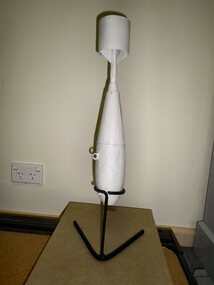
Practice Bomb Replica, c1940
Part of a navigator's training was to practice bomb aiming. These bombs detonated a liquid causing a thin spiral of smoke to rise from the impact point. Thousands were dropped near Nhill.At the end of WWII thousands of the remains of these bombs were removed for recycling. Very few remain as an example of those used during training.This is a reasonable replica of an original smoke bomb used during practice on the bombimg range south of Nhill.No markingsbomb, bomb replica, practice bomb -
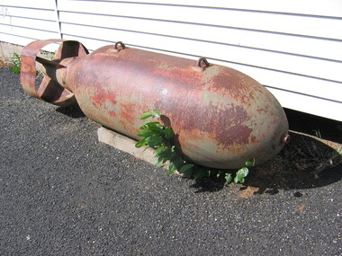 Nhill Aviation Heritage Centre
2000 lb Bomb
This bomb was found on the Bombing Range during the late 1950s.Very few of these bombs were known to have been dropped at Nhill and this is one of only two known to have been recovered unexploded.cylindrical body with rounded nose, plate steel tail fins, fuse fitting on the nose bomb, 2000 pound, bombing range -
 Nhill Aviation Heritage Centre
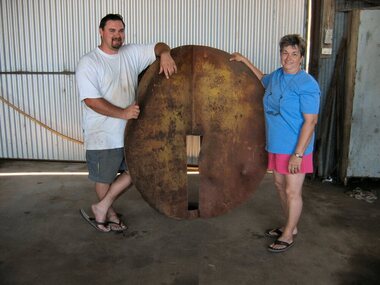
Target, 1941
This was the main target used for bombing and strafing practice during WWII by trainees at the RAAF Air School at Nhill.Original target from the bombing range. Other temporary wooden targets were used but this is the only original target that now exists.This target is made of 10mm steel plate. Two circles approximately 1.5 metres in diameter are slotted and joined at right angles so that when viewed from a distance would always appear as a round ball. Includes four support stays approx. 14 foot long 3" steel pipe with flattened ends.It is marked in several places due to being hit by bombs.target, -
 Nhill Aviation Heritage Centre
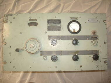
Equipment - Radio Receiver BC-639A, 1940-1949
The BC-639A is a ground based AM VHF receiver covering the nominal frequency range of 100 -156 m/cs. The set was built for the U.S. Army Air Force in WW2 as part of a communication system to communicate with aircraft. A system of similar intent was built in Australia during WW2 by Radio Corporation of Victoria (ASTOR), with the addition of FM facilities. This system used the ARl7 receiver and ATl7 transmitter. Many of the sets had been modified after the war by the then Dept of Civil Aviation for use as monitoring receivers.This type was used at the AeradioThe BC-639A is a ground based AM VHF receiver covering the nominal frequency range of 100 -156 m/cs. The set was built for the U.S. Army Air Force in WW2 as part of a communication system to communicate with aircraft. Dark grey US Military colourradio receiver, bc 639, bc 639a, 639, aeradio -
 Nhill Aviation Heritage Centre
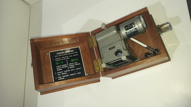
Instrument - Barometer, Aneroid Barometer, c1960s
Precision instrument used meteorological offices on air fields to measure barometric pressure141.1 Metal cube shape instrument with button switch attached is a cylindrical read out and adjuster knob. 141.2 Carry box with hinged lid and metal latch, has three hold down screws. 141.3 Stainless steel and glass thermometer 141.4 batteries 4x 15v. Standard batteries were HT Eveready B123 30v x3, LT Eveready LLII 1.5 v x1Aneroid Barometer, Type No. M.1991/A Range 800-1050mb. Ser No. 686/65, Mechanism Ltd, Made in Englandbarometer, instrument, aneroid barometer, thermometer -
Koorie Heritage Trust
Book, Brambuk Living Cultural Centre, A Journey Through Time, 1990
Intro.: Brambuk welcomes you to a journey through time. A journey that will take you through the experiences of our people the Yardwadjali and Djap Wurrung the traditional owners of the land in and around the magnificent and powerful mountain range of Gariwerd our ancient name for the Grampians...15 p. : ill. (some col.) ; 21 x 30 cm.Intro.: Brambuk welcomes you to a journey through time. A journey that will take you through the experiences of our people the Yardwadjali and Djap Wurrung the traditional owners of the land in and around the magnificent and powerful mountain range of Gariwerd our ancient name for the Grampians...community organisations -- cultural activities (including preservation and/or promotion of traditional culture). other: brambuk living cultural centre -- budja budja -- gariwerd -- halls gap. -
 Horsham Regional Art Gallery
Painting, Len ANNOIS, MacDonnell Ranges, 1964
... grampians Painting MacDonnell Ranges Len ANNOIS ...Gift of Mack Jost, 1986 -
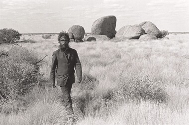 Horsham Regional Art Gallery
Photograph, Jon RHODES, John Tjakamarra, Kintore Ranges, N.T, 1974
Gift of the artist, 2001 -
Stawell Historical Society Inc
Book, Victorian national Parks Assn, The Grampians A Noble Range, 1987
... grampians Book The Grampians A Noble Range Author Jane Calder ...Author Jane CalderBelongs to DR. R Handscombe. PO Box 63 Willauragrampians -
Stawell Historical Society Inc
Book - Research, Black Range
... grampians Research Book Black Range Green 2 ring Binder. Paper ...Families and settlements of Black Range - Newspaper articles, Memories of families, maps, Black range School recordsGreen 2 ring Binder. Paper in plastic insertsBlack Range -
Stawell Historical Society Inc
Archive - Advertising Material, Wonerland Run Gariwerd, 2021
Absolute freaking intensity! You are IN the landscape, and on top of the world. It will chew you up, Spit you out, and you'll love it. All events based from Halls Gap in the mighty Grampians.Colour Card - line drawing of mountain range - rainbow sky with lightning bolt, trees. Name rises out of rock.August 28 & 29 2021 WWW. wonerlandrun.com.au Sat. *km run Fyans Flat Fubn Run / 2 km Venus Baths Run. Sun 20k sundialers, 36k Rosea Run, 60k Wonerland Run -
Stawell Historical Society Inc
Map, CFA, Map of Stawell / deep Lead Fire of 31/12/2005, 2006
Fire Started from lightning strike near Deep Lead and Burned on New years Eve with nasty North Wind, Southerly to Black range, Then Easterly towards Great western. Fire Subduded by Rain Event on 2/1/2006.Laminated Coloured Map of Stawell / Deep Lead 4/1/2006 with Fire Perimeters.CFA GIS Services Community Services -
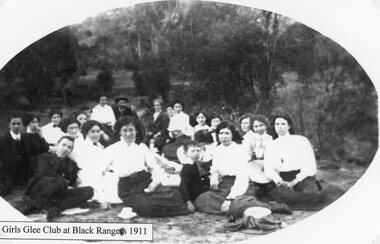 Stawell Historical Society Inc
Photograph, Girls Glee Club in the Black Ranges 1911
Girls Glee Club at Black Ranges 1911stawell -
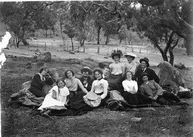 Stawell Historical Society Inc
Photograph, Picnickers probably in the Black Ranges c1900
Picnic Scenes c 1900 probably in the Black Ranges.stawell -
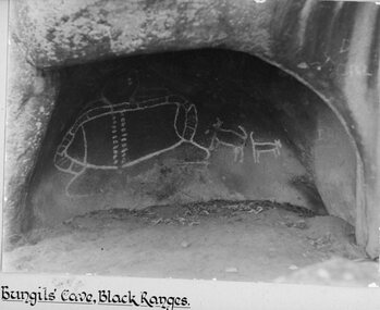 Stawell Historical Society Inc
Photograph, Bunjil’s Cave Aboriginal Rock shelter in the Black Ranges Stawell
Bunjil’s Cave Aborigional Rock shelter. Black Ranges Stawell.stawell aboriginal -
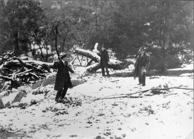 Stawell Historical Society Inc
Photograph, Snow Scene in the Black Ranges 1901-- 2 Photos
Two photographs of Snow Scene Black Ranges 1901stawell -
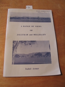 Stawell Historical Society Inc
Book, Isabel Armer, A Range of Views of Jallukar and Bellellen by Isabel Armer, 1996
... grampians Book A Range of Views of Jallukar and Bellellen by Isabel ...stawell