Showing 21 items matching "granite state"
-
 Flagstaff Hill Maritime Museum and Village
Photograph
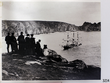
... ...granite state...Black and White Photograph sailing ship Granite State -with people watching in foreground. 253 mm x 202 mm. ...Flagstaff Hill Maritime Museum and Village 89 Merri Street Warrnambool great-ocean-road flagstaff hill warrnambool shipwrecked-coast flagstaff-hill flagstaff-hill-maritime-museum maritime-museum shipwreck-coast flagstaff-hill-maritime-village photograph granite state Black and White Photograph sailing ship Granite State -with people watching in foreground. 253 mm x 202 mm. ...Black and White Photograph sailing ship Granite State -with people watching in foreground. 253 mm x 202 mm. SH 105 Ships F - H.flagstaff hill, warrnambool, shipwrecked-coast, flagstaff-hill, flagstaff-hill-maritime-museum, maritime-museum, shipwreck-coast, flagstaff-hill-maritime-village, photograph, granite state -
 Phillip Island and District Historical Society Inc.
Photographs, 30/11/2009
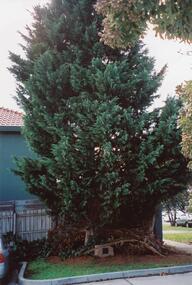
... Colour Photograph 3 Plaque mounted on Granite plinth stating "This tree was planted at the Diamond Jubilee Celebration 4-12-1983 by Mr Peter J Berwick, President Victorian Bush Nursing Association" Colour Photograph 4 Warley Avenue Street Sign mounted on concrete pole. ...Colour Photograph 3 Plaque mounted on Granite plinth stating "This tree was planted at the Diamond Jubilee Celebration 4-12-1983 by Mr Peter J Berwick, President Victorian Bush Nursing Association" Colour Photograph 4 Warley Avenue Street Sign mounted on concrete pole. ...This is a collection of 12 coloured photographs of the Warley Hospital and Nursing home donated by Meg Davis. In 1923 the Warley Hospital was established in a house purchased by Mr Thompson. The new hospital was built in 1962 and the Nursing Home Annex was added in the mid 1970's. The Hospital was closed January 31st 2008.Colour Photograph 1 Cyprus Tree in grounds of the Warley Hospital with Plaque mounted on Granite plinth at base. Colour Photograph 2 Warley Avenue Cowes, Phillip Island with trees lining the street. Colour Photograph 3 Plaque mounted on Granite plinth stating "This tree was planted at the Diamond Jubilee Celebration 4-12-1983 by Mr Peter J Berwick, President Victorian Bush Nursing Association" Colour Photograph 4 Warley Avenue Street Sign mounted on concrete pole. Colour Photograph 5 Warley Hospital driveway alongside front entrance. Colour Photograph 6 Warley Hospital with "Expressions of Interest" Sign in foreground with SOLD across the sign. Colour Photograph 7 Warley Hospital Nursing Home. Colour Photograph 8 Warley Hospital front view with garage underneath. Colour Photograph 9 Warley Hospital Nursing Home. Colour Photograph 10 Warley Hospital front close up view of garage entrance and Nursing home to the right in the background. Colour Photograph 11 Warley Hospital Main Entrance. Colour Photograph 12 Warley Hospital original Medical Centre - now Consulting Rooms. warley hospital cowes phillip island, hospitals, warley nursing home cowes phillip island, warley avenue cowes phillip island, meg davis -
 Bendigo Military Museum
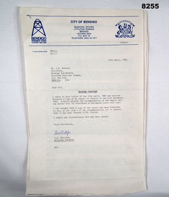
Document - CENOTAPH RESTORATION BENDIGO, City of Bendigo, C.1984
... Granite structure is good, Sandstone needs 90% replacement, brick core in good order. “Estimate of Cost” A price of $30,000 for Budget purposes but could be as low as $25,000. “Recommendation” That Restoration be referred to the 1984/85 Estimates for consideration, copies to Bendigo RSL and State President RSL....Granite structure is good, Sandstone needs 90% replacement, brick core in good order. “Estimate of Cost” A price of $30,000 for Budget purposes but could be as low as $25,000. “Recommendation” That Restoration be referred to the 1984/85 Estimates for consideration, copies to Bendigo RSL and State President RSL. ...This Document is the first in several plus photos and an article following the restoration of the Bendigo Cenotaph (Replica of the Cenotaph in Whitehall London). The letter is from the City of Bendigo Municipal Offices Lyttleton Terrace Bendigo is dated 13th April 1984 from the Building Surveyor Mr P.W. Phillips to Mr J.K. Barnes Secretary Bendigo RSL Sub Branch P.O.Box 449 Bendigo. Letter states that the Surveyors Report was adopted by Council on 21st November 1983 and would then be considered at Estimates later in the year. The Surveyors Report pages 2/3 gives a background report back to 1976 re its condition by the Building Surveyor at the time Mr R.H. Chellow and that an offer to fund at no cost was offered. Unfortunately this did not proceed. Council had approved funds for Stone work etc in the 1976/77 Estimates. The report is under several headings “Restoration of Cenotaph” being the history to this point. “Nature of Repairs Neccessary” - in brief, Extensive repairs, Granite structure is good, Sandstone needs 90% replacement, brick core in good order. “Estimate of Cost” A price of $30,000 for Budget purposes but could be as low as $25,000. “Recommendation” That Restoration be referred to the 1984/85 Estimates for consideration, copies to Bendigo RSL and State President RSL.Document 3 pages stapled together, front page is A4 and the pages 2/3 is Foolscap.Front page has a top section in blue, on the left is a depiction of a Mine Poppet Head, on the right is a Coat of Arms. The letter section is in black type, signed at the bottom in blue pen. Pages 2/3 are all black print.Page 1 points, Coat of Arms, “City of Bendigo - Progress”. “1968/84” - PWP:LT 32.7.1”. Page 2/3, “Building Surveyors Report - 21st November 1983 - B42/83 - (32.7.1)”brsl, smirsl, cenotaph, restoration -
 The Beechworth Burke Museum
Geological specimen - Feldspathic Sandstone
... granitic-type, primary crystalline, rocks. If the sandstone is dominantly plagioclase, then it is igneous in origin Sandstone features prominently in public buildings throughout Victoria. Most of the sandstone used as dimension stone in the State...granitic-type, primary crystalline, rocks. If the sandstone is dominantly plagioclase, then it is igneous in origin Sandstone features prominently in public buildings throughout Victoria. Most of the sandstone used as dimension stone in the State ...Feldspathic arenites are sandstones that contain less than 90% quartz, and more feldspar than unstable lithic fragments, and minor accessory minerals.Feldspathic sandstones are commonly immature or sub-mature.These sandstones occur in association with cratonic or stable shelf settings. Feldspathic sandstones are derived from granitic-type, primary crystalline, rocks. If the sandstone is dominantly plagioclase, then it is igneous in origin Sandstone features prominently in public buildings throughout Victoria. Most of the sandstone used as dimension stone in the State came from three sources: the Heatherlie quarry in the Grampians (Silurian), the Bacchus Marsh area (Permian), and the Barrabool Hills near Geelong (Cretaceous).Sandstone features prominently in public buildings throughout Victoria, making this specimen special as it shows the materials used by Victorian building companies. Sandstone can also be crushed, crushed stone is used in the construction of roadways and road structures such as bridges, and in buildings, both commercial and residential. This specimen is part of a larger collection of geological and mineral specimens collected from around Australia (and some parts of the world) and donated to the Burke Museum between 1868-1880. A large percentage of these specimens were collected in Victoria as part of the Geological Survey of Victoria that begun in 1852 (in response to the Gold Rush) to study and map the geology of Victoria. Collecting geological specimens was an important part of mapping and understanding the scientific makeup of the earth. Many of these specimens were sent to research and collecting organisations across Australia, including the Burke Museum, to educate and encourage further study. A feldspar-rich sandstone, a sandstone intermediate in composition between an arkosic sandstone and a quartz sandstone, containing 10% to 25% feldspar and less than 20% matrix material of clay, sericite, and chlorite. Feldspathic arenite containing less than 90 percent of the composition of quartz. Feldspar is the main composition. Feldspathic arenite may contain fragments of unstable rock, and a little amount of other minerals such as mica and heavy minerals. Some feldspathic arenite have pink or red color because of the presence of potassium feldspar or iron oxide. There are also colored light gray to white. These sandstones are usually medium to coarse grained and can contain a high percentage of granules with angular until subangular roundness. The content of the matrix can appear as the rest up to more than 15 percent, and sorting of grains can present as moderate to poorly sorted. Feldspathic sandstones are generally immature in textural maturity. Feldspathic arenite can not be judged from the structure of the sediment. Bedding can emerge from the laminate parallel to the crossbed. Fossils may appear in the layer deposited on the sea. Feldspathic arenites usually appear on the craton or the continental shelf, which can be associated with conglomerate, quartz lithic arenite, carbonate rock, or evaporites. This sandstone may also appear on the succession of sedimentary basins deposited on an unstable or deep sea, and moving arc setting. According to Pettijohn (1963) Arkose make up about 15 percent of all sandstones. Some Arkose formed in situ when the granite and related rocks disintegrate and generate granular sediments. Most of the material feldspathic sandstones derived from primary crystalline granitic rocks, such as granite or metasomatic rocks containing abundant potassium feldspar. Mineral contained in sandstones is mostly a form of plagioclase feldspar derived from quartz diorite or volcanic rock. Feldspar contained on this sandstone comes from arid to cool climates when the chemical weathering process is reduced.sandstone, natural stone, feldspathic sandstone, burke museum, geology, geological, geological specimen -
 Bendigo Historical Society Inc.
Document - CONNELLY, TATCHELL, DUNLOP COLLECTION: ACCOUNTS ESTATE OF ESTHER ISABELLE CANNING, 1893 - 1894
... stating she received from Canning two weeks wages from the Golden Age Hotel. Attached accounts from the Kent Brewery Co, Bendigo and Hunter Bros, MCCrae St Bendigo. 5 - 1894 - Receipt from Phoenix Fire Office of London, Victorian Branch. 60 Market Street Melbourne. Received from Storie H. Executors late E I Canning. 6 - 1894 - Account from Hinchcliffe Edwin, M. D. View St, Bendigo dated July 20th 1894. 7 - 1894 - Account from W Beebe & Son, Steam Granite...stating she received from Canning two weeks wages from the Golden Age Hotel. Attached accounts from the Kent Brewery Co, Bendigo and Hunter Bros, MCCrae St Bendigo. 5 - 1894 - Receipt from Phoenix Fire Office of London, Victorian Branch. 60 Market Street Melbourne. Received from Storie H. Executors late E I Canning. 6 - 1894 - Account from Hinchcliffe Edwin, M. D. View St, Bendigo dated July 20th 1894. 7 - 1894 - Account from W Beebe & Son, Steam Granite ...Document. Accounts Estate of Esther Isabelle Canning. 1 - 1894 - Ac from Mackay & Co, Bendigo Advertiser Office. 2 - 1893 - Ac from Transton Geo, Wholesale Tobacconist, Bath Buildings Bendigo. 3 - 1894 - City of Bendigo Rate Account to Gourlay, Mary Ann for property in High St. 4 - 1893 - Note from McKenzie Rosa stating she received from Canning two weeks wages from the Golden Age Hotel. Attached accounts from the Kent Brewery Co, Bendigo and Hunter Bros, MCCrae St Bendigo. 5 - 1894 - Receipt from Phoenix Fire Office of London, Victorian Branch. 60 Market Street Melbourne. Received from Storie H. Executors late E I Canning. 6 - 1894 - Account from Hinchcliffe Edwin, M. D. View St, Bendigo dated July 20th 1894. 7 - 1894 - Account from W Beebe & Son, Steam Granite, Marble & Stone Sawing Works. Mitchell St and Lyttleton Terrace for fixing headstone and re gilding old inscription etc. Dated Oct 1894. 8 - 1893 - Receipt from Phoenix Fire Office of London, Victorian Agency - Phoenix Chambers 52 Market St Melbourne dated Feb 2 and Feb 4 1893. 9 - 1894 - Ac from Hinchcliffe Edwin, M. D. View St Bendigo for professional attendance. Estate of the late Mrs Canning Golden Square, Golden Age Hotel, dated Jan 11th 1894 (document torn. 10 - Various receipts pinned together. 1893 - 1894 from City Brewery Company, High St, Bendigo, Ale and Porter Brewers Thros Canning, Golden Square. Also memorandum from Johnston & Illingworth?, City Brewery Co, Golden Square to solicitors requesting payment of accounts in the estate of the late Mrs Canning of Golden Square.cottage, miners, connelly, tatchell & dunlop, mackay & co, bendigo advertiser office, transton geo, city of bendigo, gourlay mary ann, mckenzie rosa, golden age hotel, kent brewery co, hunter bros, phoenix fire office of london, storie h, hinchcliffe edwin, w beebe & son -
 Coal Creek Community Park & Museum
Honour Roll, Kilcunda Road School Honor Roll
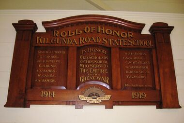
... State School (no.3337), which was located at the north east corner of the intersection of the Bena - Kongwak and Buchanans' Roads, Bena, Victoria, 3946. The school was located amongst the cypress trees at 645 Bena-Kongwak Road. The school was relocated in 2008 to the Coal Creek Community Park and Museum, 12 Silkstone Road, Korumburra, 3950 to become the Masonic Lodge building in the park display. On the west side of the intersection of the Bena - Kongwak and Buchanans' Roads is a brass plaque on a granite...State School (no.3337), which was located at the north east corner of the intersection of the Bena - Kongwak and Buchanans' Roads, Bena, Victoria, 3946. The school was located amongst the cypress trees at 645 Bena-Kongwak Road. The school was relocated in 2008 to the Coal Creek Community Park and Museum, 12 Silkstone Road, Korumburra, 3950 to become the Masonic Lodge building in the park display. On the west side of the intersection of the Bena - Kongwak and Buchanans' Roads is a brass plaque on a granite ...This WWI Honor Roll was originally displayed in the Kilcunda Road State School (no.3337), which was located at the north east corner of the intersection of the Bena - Kongwak and Buchanans' Roads, Bena, Victoria, 3946. The school was located amongst the cypress trees at 645 Bena-Kongwak Road. The school was relocated in 2008 to the Coal Creek Community Park and Museum, 12 Silkstone Road, Korumburra, 3950 to become the Masonic Lodge building in the park display. On the west side of the intersection of the Bena - Kongwak and Buchanans' Roads is a brass plaque on a granite boulder with the following inscription TO COMMEMORATE THE DISTRICT OF KILCUNDA ROAD First Surveyed 1879. This is the site of the KILCUNDA ROAD UNITING CHURCH 1911 to 1966. Diagonally opposite at 645 Bena-Kongwak Road was the site of the KILCUNDA ROAD PRIMARY SCHOOL No: 3337, 1902 to 1975. Erected by The School Mother’s Club continuing as The Kilcunda Road Social Club 2008. One of the few remaining historic items from Kilcunda Road settlement.Honour roll of varnished wood, with three panels, an undulating shaped pediment, plain columns at sides, painted gold text and the Australian Imperial Forces insignia on base.Roll of Honor, Kilcunda Road State School. In Honor of Old Scholars of this school who served the Empire in the Great War, 1914-1919, Australian Imperial Force. (X) These made the supreme sacrifice. Sister J.E. Turner , E.N. Barge, E.F. Binding (X), E.H. Bunn, D. James (X), W.James, A. James (X), R. H. James, A.G. Rose (X), C.W. Stanlake, G. Wuchatsch, R. Wuchatsch, T.E. Young kilcunda road, honour roll, state school no.3337., wwi -
 Bendigo Historical Society Inc.
Newspaper - Newspaper articles by Ken Arnold, Out &About, 2000 - 2003
... Granite Rollers 2.6.00 4. Poverty Mine 9.6.00 5. Golden Monument. St Arnaud 16.6.00 6. Turner Statue 7.7.00 7. Gold Monument. High St Golden Square 30.6.00 8. Gold Monument. Howard Square Bendigo 14.7.00 9. Lansell Statue 21.7.00 10. Shelbourne West School 18.8.00 11. Mologa’s State...Granite Rollers 2.6.00 4. Poverty Mine 9.6.00 5. Golden Monument. St Arnaud 16.6.00 6. Turner Statue 7.7.00 7. Gold Monument. High St Golden Square 30.6.00 8. Gold Monument. Howard Square Bendigo 14.7.00 9. Lansell Statue 21.7.00 10. Shelbourne West School 18.8.00 11. Mologa’s State ...Ken Arnold is a Bendigo author and publisher.A series of one hundred and thirty-five articles written by Ken Arnold and published in the Bendigo Weekly between 2000 and 2003. Each article has a topic or theme and includes historical information and details. Each article includes a photograph. The articles are stored in a red vinyl covered two ring A5 folder. Index below. Number Article Name Date 1. Centenary of Victoria 19.5.00 2. Storm Water Drain 26.5.00 3. Granite Rollers 2.6.00 4. Poverty Mine 9.6.00 5. Golden Monument. St Arnaud 16.6.00 6. Turner Statue 7.7.00 7. Gold Monument. High St Golden Square 30.6.00 8. Gold Monument. Howard Square Bendigo 14.7.00 9. Lansell Statue 21.7.00 10. Shelbourne West School 18.8.00 11. Mologa’s State Schools 25.8.00 12. Salinity Stone. Pyramid Hill 1.9.00 13. Cairn. Carisbrook 8.9.00 14. Commemorative Markers. Taradale 15.9.00 15. Burke Monument. Castlemaine 22.9.00 16. Cairn. Harcourt area 29.9.00 17. Cairn Marks Gold Route 6.10.00 18. Volcanic Rock Cairn. Woodstock 13.10.00 19. Garfield Water Wheel 20.10.00 20. Anticline. Castlemaine 27.10.00 21. Lawson Bridge 10.11.00 22. Plaque. Sutton Grange area 17.11.00 23. Memorial Cairn. Maryborough 1.12.00 24. Lonely Grave 8.12.00 25. Moonlight Flat Church 5.1.01 26. Historic Church. Near Tullaroop reservoir 12.1.01 27. Granite Statue. Castlemaine 19.1.01 28. Marker. Near Tullaroop reservoir 25.1.01 29. Church Site. Mologa 2.2.01 30. Church Site. Mologa 9.2.01 31. Plaque. Mologa 16.2.01 32. Mincha School 23.2.01 33. Historic Marker. Mincha 2.3.01 34. Expedition Marker. Pyramid Hill 9.3.01 35. Irrigation Marker. Tragowel 16.3.01 36. Mologa School Sites 23.3.01 37. Cairn. Pyramid Hill 30.3.01 38. Plaque. Pyramid Hill 6.4.01 39. Bristol Hill Lookout Tower. Maryborough 12.4.01 40. Eppalock Reservoir 20.4.01 41. Colbinabbin Cairn 27.4.01 42. Mount Macedon Cross 4.5.01 43. Memorial Gateway. Macedon 11.5.01 44. Cairn. Daylesford 18.5.01 45. Grave. Carlsruhe 25.5.01 46. Water Tower. Elmore 1.6.01 47. State School Site. Glenalbyn 8.6.01 48. Cairn. Kanya 15.6.01 49. Lonely Grave. Wedderburn 22.6.01 50. Church Cairn. Glenalbyn 29.6.01 51. Kamarooka School 6.7.01 52. Granite Marker. Moyston 13.7.01 53. Memorial Park. Kerang 20.7.01 54. Water Plaque. Bears Lagoon 27.7.01 55. Cemetery. Bears Lagoon 3.8.01 56. Race Monument 10.8.01 57. Cairn. Pyalong 17.8.01 58. Cairn. In memory of Edward Parker 24.8.01 59. Mt Macedon 31.8.01 60. Mt Macedon Cairn 7.9.01 61. Expedition Pass. Chewton 14.9.01 62. Granite Archway. St Arnaud 21.9.01 63. Stuart Mill School Site 28.9.01 64. School Site. Beazley’s Bridge 5.10.01 65. Fosterville 12.10.01 66. Barnadown 19.10.01 67. Salisbury School Site 26.10.01 68. Cricket History at Wattle Flat 2.11.01 69. School Site. Waterloo Plains 9.11.01 70. Carapooee School Site 11.01 71. Turkish Gun. Maldon 11.01 72. Kooreh 30.11.01 73. Marnoo East School 7.12.01 74. Bulgana Site 14.12.01 75. Emu School 21.12.01 76. Kooroocheang 4.1.02 77. Church Site. Gre Gre North 11.1.02 78. Carmens Tunnel. Maldon 18.1.02 79. Monument. Maldon 25.1.02 80. Woodfull Plaques. Maldon 1.2.02 81. Carapooee. St Peters Anglican Church 8.2.02 82. Cairn. Kingower 15.2.02 83. Cob & Co Stopover. Rheola 22.2.02 84. Flynn Monument 1.3.02 85. The Welcome Stranger. Moliagul 8.3.02 86. Campbell’s Creek Reserve 15.3.02 87. Mine. Fryerstown 22.3.02 88. Escott Grave. Near Chewton 28.3.02 89. School No 808. Kurting area 5.4.02 90. Graves. Bendigo Creek 10.5.02 91. School. Fish Point, Benjeroop North 17.5.02 92. Old Township. Diggora 24.5.02 93. Diggora West (1) 31.5.02 94. Diggora West (2) 7.6.02 95. School No 2735. Gower East 14.6.02 96. Pannoomilloo 21.6.02 97. Kamarooka Settlement 28.6.02 98. Mincha West State School No 1931 5.7.02 99. Bridges. Arnold 12.7.02 100. Woodvale 19.7.02 101. A Famous Son of Raywood. Jack Donaldson 26.7.02 102. Tandarra Area Schools 2.8.02 103. Dingee 9.8.02 104. Avonmore 30.8.02 105. Myola East School 6.9.02 106. Colbinabbin West 13.9.02 107. Colbinabbin West School 20.9.02 108. Runnymede area 27.9.02 109. Wanalta 4.10.02 110. School Sites. Between Wanalta and Carop 11.10.02 111. Burramboot 18.10.02 112. Kangaroo Chair. 25.10.02 113. Mincha South 1.11.02 114. Woodlands Church 8.11.02 115. School site. Sylvaterre 15.11.02 116. Terrick Terrick 22.11.02 117. Leitchville 29.11.02 118. Pennyweight Cemetery. Castlemaine 6.12.02 119. Mincha Area 13.12.02 120. Musk School 20.12.02 121. Dowie Park. Carisbrook 3.1.03 122. Neereman School Site 10.1.03 123. Bald Rock 17.1.03 124. Sylvaterre School Site 24.1.02 125. Carlsruhe 31.1.02 126. Athenaeum. Maldon 7.2.03 127. School. Mincha West 14.2.03 128. Yarraberb 21.2.03 129. Settlement Marker. Ravenswood Estate 28.2.03 130. Comini Reserve. Ravenswood 7.3.03 131. Ironbark and Gold Track. Whroo 14.3.03 132. Burke and Wills Obelisk. Castlemaine 21.3.03 133. James Cook Statue. Myers St Bendigo 28.3.03 134. St Marys Church. Axedale 4 .4.03 135. Butter Factory Site. Warragamba 11.4.03 events, monuments, historical sites, landmarks -
 Department of Energy, Environment and Climate Action
Beechworth FCV District office sign
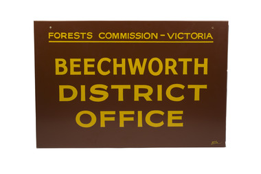
... The granite building in the Beechworth's historic precinct was once the Gold Warden's Office and is one of the town's original buildings. The FCV was the main government authority responsible for management and protection of State forests in Victoria between 1918 and 1983. ...The granite building in the Beechworth's historic precinct was once the Gold Warden's Office and is one of the town's original buildings. The FCV was the main government authority responsible for management and protection of State forests in Victoria between 1918 and 1983. ...This sign proudly hung outside the Forests Commission Victoria (FCV) Beechworth office which is now site of the Forestry Heritage Museum. The granite building in the Beechworth's historic precinct was once the Gold Warden's Office and is one of the town's original buildings. The FCV was the main government authority responsible for management and protection of State forests in Victoria between 1918 and 1983. The Commission was responsible for ″forest policy, prevention and suppression of bushfires, issuing leases and licences, planting and thinning of forests, the development of plantations, reforestation, nurseries, forestry education, the development of commercial timber harvesting and marketing of produce, building and maintaining forest roads, provision of recreation facilities, protection of water, soils and wildlife, forest research and making recommendations on the acquisition or alienation of land for forest purposes″. The Forests Commission had a long and proud history of innovation and of managing Victoria's State forests but in September 1983 lost its discrete identity when it was merged into the newly formed Victorian Department of Conservation, Forests and Lands (CFL) along with the Crown Lands and Survey Department, National Park Service, Soil Conservation Authority and Fisheries and Wildlife Service. After the amalgamation the management of State forests and the forestry profession continued but the tempo of change accelerated, with many more departmental restructures occurring over the subsequent four decades. Responsibilities are currently split between the Department of Energy, Environment and Climate Action (DEECA), Forests Fire Management Victoria (FFMV), Parks Victoria, Melbourne Water, Alpine Resorts Commission, the State Government-owned commercial entity VicForests and the privately owned Hancock Victorian Plantations (HVP).Large office sign. Hand painted in traditional FCV mission brown and gold colour scheme.forests commission victoria (fcv), forest signs -
 City of Melbourne Libraries
Photograph, Bull, Hugh Jones, 1897-1993, Princes Bridge Centenary pylons under construction
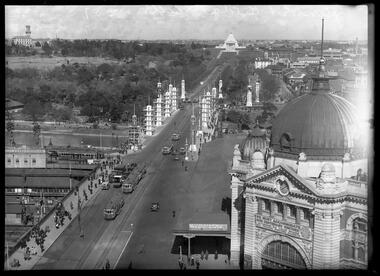
... The bluestones were quarried from Footscray, the Malmsbury stones were from quarries at Kyneton, and the granite from Harcourt. The cost was met by the State of Victoria, City of Melbourne, and six out of seven of its municipalities, and their coats of arms feature on the bridge. ...The bluestones were quarried from Footscray, the Malmsbury stones were from quarries at Kyneton, and the granite from Harcourt. The cost was met by the State of Victoria, City of Melbourne, and six out of seven of its municipalities, and their coats of arms feature on the bridge. ...Princes Bridge Centenary pylons under construction Possibly taken from Young and Jacksons Hotel (formerly Princes Bridge Hotel) on the corner of Flinders and Swanston streets, Flinders Street Station’s clocks and main entrance dominate, along with its distinctive copper dome and decorative façade. The time on the main clock is 1.40pm, and the sign underneath, reflecting Melbourne’s upcoming Centenary reads, “We must accommodate our Centenary visitors! Citizens! Do your share by taking paying guests.” At left is the original Princes Bridge Station, today the site of Federation Square. The riverside tram terminus advertises a Café/Tobacconist/Refreshment Room selling cigars & cigarettes, fountain drinks & confectionery, and in smaller text: “Leave your boot repairs here”. Nearly everyone is dressed in dark suits, coats and hats. The footpaths are wide and there are no traffic lights. The roadway stretches towards the Shrine of Remembrance, not yet dedicated but very dominant on the skyline. Government House is clearly visible across the wide parkland that would come to be known as Kings Domain and that is an area of deep importance to the people of the Eastern Kulin. Originally, Birrarung was part of a network of swamps and lagoons linked to the course of the river. From 1896, Public Works Department engineer Carlo Catani, oversaw a new channel to straighten the river and the swamps and lagoons were filled with spoil from the channel works. From the same vantage point today, only the top of the tower of Government House would be visible. The photo captures the pylons along Princes Bridge, mid-construction and being installed to mark Melbourne’s Centenary. The pylons were not without controversy. Both The Argus and The Age bemoaned them for being “made almost entirely of imported softwood timber”, denying work to native hardwood timber workers and sawmillers, and leading visitors to think Australia did not have its own exceptional native hardwoods. The pylons were also variously described in their incomplete state, as unimaginative and resembling an oilfield. Published: The Age 5 September 1934 Featured in "Newsworthy: Melbourne in photographs 1933-1936" exhibition at East Melbourne Library, October to December 2023. Exhibition caption by project volunteer, Louise McKenzie Photographer notations on slide: "Pylons + St Kilda Rd C57" Published: Age (Melbourne, Vic. : 1854 - 1954), Wednesday 5 September 1934, page 11 Published title: DECORATIONS -- THEN AND NOW. Published caption: "Although not completed yet, some impression of the effect of the decorations on Princes-bridge may be obtained from the first picture which shows the majestic sweep of St Kilda road with the Shrine of Remembrance and Government House dominating the horizon. The area to the left of St. Kilda-road and in front of Government House is portion of the area which it is proposed to call the King's Domain, which extends to Domain-road and Anderson-street..." Description: East-facing, elevated view of Flinders Street Station and Princes Bridge, featuring partially completed pylons erected for Melbourne's Centenary celebrations. The Shrine of Remembrance and Government House can be seen in the distance. In the foreground are trams, cars and trucks, pedestrians, Batman Avenue tram terminus and refreshment rooms. Signage on Flinders Street Station encourages citizens to accommodate Centenary visitors. The Melbourne Centenary was held 1934-35 in celebration John Batman's proclamation that Melbourne "the place for a village". Centenary events included a visit by Prince Henry, Duke of Gloucester. A Centenary Cake measuring 50 feet in height and ten tons in weight was cut into 250,000 pieces and sold at 1 shilling per piece for charity. Spectacular floodlighting of city landmarks, the creation of the Pioneer Women's Memorial Garden, and the MacRobertson Air Race from London, were other notable activities. Research by project volunteer, Louise McKenzie: The photo in The Age collage of 5 September 1934 has a slightly cropped foreground. The original photo has been taken from an elevated vantage point, most probably the roof of the Nicholas Building on the corner of Flinders and Swanston streets. The right foreground is dominated by the main “clocks” entrance to Flinders Street Station, showing its distinctive copper dome and decorative façade. The time on the main clock is 1.40 pm. The main sign on the front of the Station reads, "We Must Accommodate our Centenary Visitors! Citizens! Do your share by taking paying guests. Write to The Official Centenary Accommodation Bureau, 436 Collins St. City. Tel M 4671”. Another sign at eye level at the main entrance says: “Cheap Trips on Sundays”. The sign on the end of the roof along the eastern side of the station reads, “The Babies Need Your Help! Support Broadmeadows Foundling Hospital Appeal. July and August”. Run by the Sisters of St Joseph of the Sacred Heart, St Joseph’s Foundling Hospital was a purpose built infants’ home for up to 300 babies, plus accommodation for expectant mothers, mainly single women. In the early 1930s, the department (Victorian Children’s Welfare Department) contracted St Joseph’s Foundling Hospital to care for an additional 60 infant state wards, and up to 175 non wards at any given time. In 1931 it also operated a mothercraft training school. The centre foreground shows the commencement of Princes Bridge. Beneath the left side of the bridge was the site of the original Princes Bridge Station, by this time incorporated into Flinders Street Station, and today the area is the site of Federation Square. It was linked to Flinders Street station by the railway tracks that ran underneath the northern approach to the bridge. This photo shows a tram terminus which has a Café/Tobacconist/Refreshment Room, selling cigars & cigarettes, fountain drinks & confectionary, and a sign: Leave your boot repairs here. In the foreground is a wide roadway running south/north, comprising two vehicle lanes each heading north/south, and a central section containing two sets of tram tracks. There are cars, buses and delivery vans on the roadway. The trams visible are Glen Iris (Route No. 6; tram no. 448), Toorak (Route No. 8, tram no. 333), ? (No. 7), ? (No. 1), and ? (No. 2A). The footpaths are extremely wide. There is a square newspaper/magazine stand on the eastern side footpath. And also a “Ferry” sign. There are no traffic lights, but a policeman is visible on the roadway. There are pedestrians – men, women, children, a porter with trolley, women with prams. Clothing comprises dark suits, coats and hats for nearly everyone. There are double headed “Collins Street” lights along the side of the roadway, and along the northern riverbank. The roadway in the foreground is an extension of Swanston Street, which becomes Princes Bridge, then St Kilda Road, stretching towards the Shrine of Remembrance, and diverting past it. The Shrine had not yet been officially dedicated, and looks very white and dominant on the skyline. On the LHS of St Kilda Road, Government House is clearly visible across the wide parkland to be known as Kings Domain. The Kings Domain area is important to the people of the Eastern Kulin nation, and also has historical importance for its association with the early settlement of Melbourne and the foundation of British colonial administration in Victoria. On the southern side of the Yarra River (Birrarung) an historic rowing boathouse is visible, located adjacent to the Alexandra Gardens. Originally Birrarung was part of a network of swamps and lagoons linked to the course of the river. From 1896, under the guidance of engineer Carlo Catani* a new channel to straighten the river was created and the swamps and lagoons were filled with spoil from the channel works. The gardens were then created and completed in time for a Royal visit by the Duke of York in May 1901. The gardens are named after Alexandra of Denmark, the wife of King Edward VII. Both these areas, plus the Royal Botanic Gardens Victoria, Shrine of Remembrance Reserve, Sidney Myer Music Bowl, Government House, and the Queen Victoria Gardens together form the Domain Parklands. The extent of the subsequent plantings is evident today, where from the same vantage point only the top of the tower of Government House would be visible. *Catani was born in Florence in 1852, but after arriving in Melbourne worked as a civil engineer for the Victorian Government. His last major project was the reclamation of the foreshore of St Kilda, envisaged in the style of a European resort, complete with a split level esplanade, bathing pavilions, dance halls, amusements and a French-Italian style of landscape complete with palms. The gardens at the end of Fitzroy Street, St Kilda, now bear his name. The historic boathouse visible across the Yarra is another glimpse into Melbourne’s past. “Boathouse Row” comprises 7 amateur rowing clubs, the first established in 1859 (Melbourne University Boat Club). Other Clubs were Richmond, Melbourne, Banks, Melbourne Grammar School, Yarra Yarra and Mercantile. South of the river and west of the bridge is an area today developed into the Melbourne arts precinct of Hamer Hall and the Arts Centre. But at this time it was the home of Wirths Olympia Circus, which comprised Wirths Pleasure Park (an amusement park), a 5,000 seat auditorium – Hippodrome, a roller skating rink, a glaciarium, a cinema, and the Green Mill Dance Hall. Dog shows were also held at Olympia. The Green Mill Dance Hall closed in 1950, and the remainder of the Wirth buildings on site were destroyed by fire in December 1953. The feature of the photo is the pylons erected along Princes Bridge to mark Melbourne’s Centenary in 1934. The sixteen plastered pylons were designed by Roy Prentice, the second person to qualify as an architect at The University of Melbourne’s Bachelor of Architecture degree, in 1933, aged 27. Simon Reeves in his article marking the 100th birthday of Roy Prentice on 20 June 2006 reports that the State Electricity Commission sponsored this work, and the Argus reported that “… the pylons were “illuminated from within to give the effect of soft radiance”. Australia Home Beautiful 1 Oct 1934 reports in a very detailed and comprehensive article: The 10 taller pylons, including flagpole, were 48 ft, with a base of 8 ft. Timber-framed and faced with fibrous plaster and galvanised sheet iron, each structure was securely bolted to a concrete foundation three feet in depth. Panels of glass let into the shaft of each pylon were indirectly lit by 40, 100 watt lamps, and the upper bank of internal lamps were dyed so as to flood the panels with a deep red light. The decorative painted shields and flagpoles/pennants were illuminated by three 200 watt projectors concealed in the roof of each pylon, and were part of an electric night light decoration scheme involving 28 miles of wire to supply more than 20,000 lights. An article in the Argus on 18 October 1934 provided minute detail of the lighting erected in Melbourne for the Centenary, converting it “… into a coloured fairyland by night.” The estimated cost of 10 pounds per hour the lights were on. The display included 800 standard light poles 30 feet high which were tiered with electric bulbs concealed in inverted cones, 138 specially designed “Venetian poles” draped in flags trophies and streamers. The streets included in the electric night light decoration scheme were Bourke Street from Spring to William, the entire length of Collins Street, Flinders Street from Elizabeth to Spring, Lonsdale Street from Elizabeth to Swanston, Swanston and Elizabeth Streets from Flinders to Lonsdale, and parts of Springs and Spencer Streets. Together with the Princes Bridge pylons, approximately 28 miles of wire was required to supply power to the more than 20,000 lights. And that is just in the city of Melbourne. It was estimated the same amount of lighting was duplicated among other local councils. The pylons were not without controversy. The Argus on 28 August 1934 in an article headed “Imported Timber in Pylons” reported that the Princes Bridge pylons are “made almost entirely of imported softwood timber”, and have therefore denied work to native hardwood timber workers and sawmillers. The same day the Melbourne Age ran a similar story, bemoaning the fact that foreign oregon had been used which may lead tourists to think Australia did not have its own exceptional native hardwoods. A Camberwell City Councillor described the pylons as unimaginative, and the Herald reported that skeletons of pylons for the Centenary decorations in their present form led the area to resemble an oilfield! The Yarra River and Princes Bridge have long been a focal point of Melbourne life. In the early days of European settlement in Melbourne a rope-hauled punt carried people across the Yarra River. A surge in population and increased shipping traffic created a need for a bridge. There was difficulty in agreeing on a suitable site for the bridge (options were crossing at Elizabeth, Swanston, Queen or Market Streets), but the NSW Government favoured Swanston Street and the Melbourne Town Council decided on a temporary bridge across the Yarra spanning from the foot of Swanston Street. This first bridge was a single span timber toll bridge designed by Scottish born bridge designer David Lennox, and completed in 1845. It was 120 feet long, had a roadway of 17 feet wide, and a footpath on one side of 4 feet. It was leased to the Melbourne Bridge Company in the name of Robert A Balbirnie. The tollhouse was on the north side of the river and the toll keeper, Patrick Doherty, was credited with saving nine lives during the four years he was in charge of the toll station. The second bridge was stone (completed 1850), and named Prince’s Bridge after the HRH Prince of Wales, later Edward VII. It was designed with an elliptical single arc and an exceedingly small rise in proportion to the span. However, this design created an obstacle for flood waters, and together with Melbourne’s increasing population it was quickly apparent that a new bridge was required. At its opening on 15 November 1850 coincided with the imminent declaration of Victoria as a separate colony, it provided a moment of great celebration for Melbournians and “The opening ceremony was described as the grandest processional display witnessed in the colony.” (ToMelbourne.com.au) Princes Bridge in its present form, as depicted in this photograph, was designed by Jenkins, D’Ebro and Grainger, and constructed in 1886-88 by David Munro. John Grainger (father of Australian composer Percy Grainger) did the majority of the design work for the bridge. The structure was to have three arches each 96 feet wide measured across the river, and the banks on both sides were raised to allow more space for floodwater to flow. St Kilda Road was originally many feet below the current level. The bridge is of architectural significance for its substantial size, giant half columns, extensive use of wrought and cast iron, decorative elements (cast-iron lamps) and the skilled stonemasonry in the construction of the abutments and piers. Its main design features are similar to those of Blackfriars Bridge in London (1870). The bluestones were quarried from Footscray, the Malmsbury stones were from quarries at Kyneton, and the granite from Harcourt. The cost was met by the State of Victoria, City of Melbourne, and six out of seven of its municipalities, and their coats of arms feature on the bridge. The building of the bridge reflected the boom period of Melbourne, including the Victorian gold rush 1851- late 1860s, and its contractor, David Munro, was also responsible for the construction of Queens Bridge and Sandridge Railway Bridge. The Centenary pylons are no longer in place, but today this intersection still plays a major part in Melbourne’s daily life: people still meet “under the clocks” at Flinders Street station, and the route in and out of the city along St Kilda Road is often a feature of parades such as Moomba, the Grand Final Parade, and of course the Anzac Day Parade which commences at the Princes Bridge intersection and finishes at the Shrine of Remembrance. There are many tram routes, which cross the Bridge, and it directs pedestrians towards the Arts Precinct, the various components of Domain Park, plus the Southbank restaurant and rowing precincts. Even though this is a street scene, it feels very intimate; the viewer is instantly immersed in the activity of a Melbourne afternoon, looking down St Kilda Road from a viewpoint near today’s Federation Square. References: DECORATIONS -- THEN AND NOW. (1934, September 5). The Age (Melbourne, Vic. : 1854 - 1954), p. 11. Retrieved September 21, 2023, from http://nla.gov.au/nla.news-article205880269 'Flinders Street railway station', Wikipedia, https://en.wikipedia.org/wiki/Flinders_Street_railway_station 'St Joseph’s Foundling Hospital (1901-75)', Finding Records, Department of Health and Human Services, State of Victoria, https://www.findingrecords.dhhs.vic.gov.au/collectionresultspage/St-JosephsFoundling-Hospital-Babies-Home#departmental-administration 'Alexandra Gardens', City of Melbourne, https://www.melbourne.vic.gov.au/community/parks-open-spaces/major-parks-gardens/Pages/alexandra-gardens.aspx 'Wirths Circus', Wikipedia, https://en.wikipedia.org/wiki/Wirth's_Circus 'Roy Prentice: Centenary Architect', Built Heritage Pty Ltd, Simon Reeves, https://www.builtheritage.com.au/downloads/prentice.pdf 'Princes Bridge', Heritage Council Victoria, https://vhd.heritagecouncil.vic.gov.au/places/817 PORT PHILLIP. (1846, April 1). The Sydney Morning Herald (NSW : 1842 - 1954), p. 3. Retrieved September 21, 2023, from http://nla.gov.au/nla.news-article12886251 'Edward VII', Wikipedia, https://en.wikipedia.org/wiki/Edward_VII 'Princes Bridge', ToMelbourne.com, https://tomelbourne.com.au/princes-bridge/ 'Princes Bridge', eMelbourne, https://www.emelbourne.net.au/biogs/EM01189b.htm 'Princes Bridge', Australia for everyone, http://australiaforeveryone.com.au/files/melbourne/princes-bridge.html 'Victorian gold rush', Wikipedia, https://en.wikipedia.org/wiki/Victorian_gold_rush IMPORTED TIMBER IN PYLONS (1934, August 28). The Argus (Melbourne, Vic. : 1848 - 1957), p. 9. Retrieved September 21, 2023, from http://nla.gov.au/nla.news-article10952507 Princes-Bridge Pylons. (1934, August 28). The Age (Melbourne, Vic. : 1854 - 1954), p. 7. Retrieved September 21, 2023, from http://nla.gov.au/nla.news-article205532235 Pylons Appear Near Princes Bridge (1934, August 18). The Herald (Melbourne, Vic. : 1861 - 1954), p. 1. Retrieved September 21, 2023, from http://nla.gov.au/nla.news-article243104375 PRINCES-BRIDGE PYLONS. (1934, September 20). The Age (Melbourne, Vic. : 1854 - 1954), p. 10. Retrieved September 21, 2023, from http://nla.gov.au/nla.news-article205873535 28 Miles of Wire (1934, October 18). The Argus (Melbourne, Vic. : 1848 - 1957), p. 1 (The Junior Argus). Retrieved September 21, 2023, from http://nla.gov.au/nla.news-article10977836 'Historical references for Boathouse Row, Melbourne', http://boathouserowmelbourne.com.au/history/ 'ITALIAN DELEGATION TO HONOUR CARLO CATANI, DESIGNER OF THE ST KILDA FORESHORE, St Kilda Historical Society, 2001, https://web.archive.org/web/20070928061938/http://www.skhs.org.au/~SKHSarticles/articles/Carlo_Catani.html# HISTORY IN LIGHTS (1934, July 12). The Herald (Melbourne, Vic. : 1861 - 1954), p. 16. Retrieved September 21, 2023, from http://nla.gov.au/nla.news-article243172436 'Dressing Melbourne for the Duke', The Australian home beautiful: a journal for the home builder. Vol 12 No. 10 (1 October 1934), page 21, 58. Retrieved September 14, 2023, from http://nla.gov.au/nla.obj-2950922209Photographer notations on slide: "Pylons + St Kilda Rd C57".centenaries, bridges, lighting, flinders street railway station -
 Tatura Irrigation & Wartime Camps Museum
Photograph, Goulburn Weir, 1890
... Tatura Irrigation & Wartime Camps Museum 49 Hogan Street Tatura the-murray Taken by photographer for State Rivers and Water Supply Commission. goulburn weir victorian state rivers and supply commission Medium sized black and white photograph. Concrete and iron weir structure - granite stone spillway with minor flow of water in centre. ...Taken by photographer for State Rivers and Water Supply Commission.Medium sized black and white photograph. Concrete and iron weir structure - granite stone spillway with minor flow of water in centre. Close up photograph sparse trees on the bank beyond. Gas lamps on walkway.goulburn weir, victorian state rivers and supply commission -
Tatura Irrigation & Wartime Camps Museum
Photograph, Goulburn Weir Gate Replacement, 1970s
... Tatura Irrigation & Wartime Camps Museum 49 Hogan Street Tatura the-murray Taken by photographer for State Rivers and Water Supply Commission. goulburn weir victorian state rivers and supply commission Medium sized black and white photograph. Workmen on the job - replacing gates at Goulburn Weir 1965. Granite ...Taken by photographer for State Rivers and Water Supply Commission.Medium sized black and white photograph. Workmen on the job - replacing gates at Goulburn Weir 1965. Granite blocks and rubble right of picture, workmen pushing barrow of blocks towards right, concrete replacement gates centre picture, S.R and W.C caterpillar tracked dragline near top right corner.goulburn weir, victorian state rivers and supply commission -
Tatura Irrigation & Wartime Camps Museum
Photograph, May, 1888
... Tatura Irrigation & Wartime Camps Museum 49 Hogan Street Tatura the-murray Taken by photographer for State Rivers and Water Supply Commission. goulburn weir victorian state rivers and supply commission Medium sized black and white photograph. Weir being constructed of granite blocks quarried from nearby Mt. ...Taken by photographer for State Rivers and Water Supply Commission.Medium sized black and white photograph. Weir being constructed of granite blocks quarried from nearby Mt. Black. Four men standing on the granite steps - gantry right mid-picture. Note: Empty cart resting mid-top of picture.goulburn weir, victorian state rivers and supply commission -
Tatura Irrigation & Wartime Camps Museum
Photograph, May, 1888
... Tatura Irrigation & Wartime Camps Museum 49 Hogan Street Tatura the-murray Taken by photographer for State Rivers and Water Supply Commission. goulburn weir victorian state rivers and supply commission Medium sized black and white photograph. Weir wall of granite blocks nearing completion viewed from downstream. ...Taken by photographer for State Rivers and Water Supply Commission.Medium sized black and white photograph. Weir wall of granite blocks nearing completion viewed from downstream. Construction camp of tents and sheds mid-picture beyond wall.goulburn weir, victorian state rivers and supply commission -
 City of Ballarat
Artwork, other - Public Artwork, William Dunstan VC Memorial, 1995
... granite in memory of Ballarat born soldier, William Dunstan, who served with honour in Gallipoli, WWI. His unit successfully defended a post despite being seriously wounded. He and one mate were the only survivors of the 10 men defending the trench and all were awarded the Victoria Cross. Following the war Dunstan worked as manager and director of the Herald and Weekly Times. The memorial is of historical significance to the people Ballarat first world war WWI William Dunstan Conflict War In honour of William Dunstan, VC 1895-1957. William Dunstan was born in Ballarat East and educated at Golden Point State ...The Dunstan Memorial is a minimal form of rough-cut bluestone and sheet granite in memory of Ballarat born soldier, William Dunstan, who served with honour in Gallipoli, WWI. His unit successfully defended a post despite being seriously wounded. He and one mate were the only survivors of the 10 men defending the trench and all were awarded the Victoria Cross. Following the war Dunstan worked as manager and director of the Herald and Weekly Times.The memorial is of historical significance to the people BallaratThis is a minimal form of rough-cut bluestone and sheet granite in memory of Ballarat born soldier who served with honor in Gallipoli. His unit successfully defended a post despite being seriously wounded. He and one mate were the only survivors of the 10 men defending the trench and all were awarded the Victoria Cross. In honour of William Dunstan, VC 1895-1957. William Dunstan was born in Ballarat East and educated at Golden Point State School. Shortly after the outbreak of the First World War, 19 year old Dunstan enlisted in the 7th Battalion, 2nd Brigade, 1st Division of the Australian Imperial Forces. Within 3 weeks he was posted to Gallipoli and was immediately embroiled in the Battle of Lone Pine. Early on the morning of 9th August, 1915, Dunstan and 10 other men were defending a trench captured from the Turks. The enemy launched repeated counter attacks and suffered heavy casualties. Only 3 surviving Australians remained and were rebuilding the blown-up barricade of sandbags when the Turks launched a final vicious assault to regain the trench. Struggling to defend their position, the three Australians resorted to catching the Turkish hand bombs and throwing them back at the enemy or smothering those that landed with Turkish great-coats. Hand bombs killed a 10th defender and wounded both Dunstan and his only remaining companion. Again the Turks were driven back and this time the two wounded Australians were left alone until later relieved and hospitalised. As a result of the intensity of the fighting and the tenacity of the 3 defenders, each was awarded Victoria Crosses for their most conspicuous bravery. Following the war, Dunstan enjoyed a successful career to become the Managing Director of the Herald and Weekly Times. He died in Melbourne aged 62 and is remembered with respect by the citizens of Ballarat.first world war, wwi, william dunstan, conflict, war -
 Wodonga & District Historical Society Inc
Album - Hume Reservoir Australia Album - Work inside levee bank, September 1924
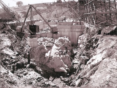
... State for Dominion Affairs on the occasion of his visit to the Hume Reservoir on 2nd November 1927. This album is of local and national significance as it documents the planning and development of the Hume Reservoir up to 1927. It was the largest water reservoir in the British Empire. The album records the pioneering engineering work that went into its construction. Hume Reservoir Australia River Murray Waters Scheme Hume Reservoir Construction DEPARTMENT OF PUBLIC WORKS, N.S.W. RIVER MURRAY WATERS SCHEME. HUME RESERVOIR. 15. Work inside levee bank. Foundations of spillway showing granite ...This set of photos is from a leather bound album bearing the inscription "HUME RESERVOIR AUSTRALIA" plus 'The Rt. Hon. L. C. M. S. Amery, P. C., M .P.' all inscribed in gold. It was presented to The Rt. Hon. L. C. M. S. Amery, P. C., M. P, Secretary of State for Dominion Affairs on the occasion of his visit to the Hume Reservoir on 2nd November 1927. This album is of local and national significance as it documents the planning and development of the Hume Reservoir up to 1927. It was the largest water reservoir in the British Empire. The album records the pioneering engineering work that went into its construction.DEPARTMENT OF PUBLIC WORKS, N.S.W. RIVER MURRAY WATERS SCHEME. HUME RESERVOIR. 15. Work inside levee bank. Foundations of spillway showing granite foundations and a fault in the formation. New South Wales. September 1924.hume reservoir australia, river murray waters scheme, hume reservoir construction -
 Wodonga & District Historical Society Inc
Album - Hume Reservoir Australia Album - View along the face of the quarry, August 1927
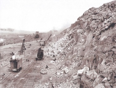
... State for Dominion Affairs on the occasion of his visit to the Hume Reservoir on 2nd November 1927. This album is of local and national significance as it documents the planning and development of the Hume Reservoir up to 1927. It was the largest water reservoir in the British Empire. The album records the pioneering engineering work that went into its construction. Hume Reservoir Australia River Murray Waters Scheme Hume Reservoir Construction DEPARTMENT OF PUBLIC WORKS, N.S.W. RIVER MURRAY WATERS SCHEME. HUME RESERVOIR. 35. Quarry. View along the face of the quarry. Granite ...This set of photos is from a leather bound album bearing the inscription "HUME RESERVOIR AUSTRALIA" plus 'The Rt. Hon. L. C. M. S. Amery, P. C., M .P.' all inscribed in gold. It was presented to The Rt. Hon. L. C. M. S. Amery, P. C., M. P, Secretary of State for Dominion Affairs on the occasion of his visit to the Hume Reservoir on 2nd November 1927. This album is of local and national significance as it documents the planning and development of the Hume Reservoir up to 1927. It was the largest water reservoir in the British Empire. The album records the pioneering engineering work that went into its construction.DEPARTMENT OF PUBLIC WORKS, N.S.W. RIVER MURRAY WATERS SCHEME. HUME RESERVOIR. 35. Quarry. View along the face of the quarry. Granite is being quarried here for the concrete material. Blocks from 2-8 tons in weight are reserved for “plums”. Quantities of large size spalls are sent to Victoria for the toe of the embankment and other purposes but the greatest proportion of the stone is crushed at the quarry to 2½ inches gauge for concrete aggregate. Two steam navvies and two steam travelling cranes are at work on the face. New South Wales. August 1927.hume reservoir australia, river murray waters scheme, hume reservoir construction -
 Wodonga & District Historical Society Inc
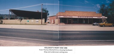
Photograph - Holloways Building Supplies
... A timber mill that had been built at Tallangatta by State Rivers and Water for the purpose of establishing New Tallangatta, was purchased by Holloway Brothers as an extension of their Shelley operation. In 1954 a new mill was built at Granite...A timber mill that had been built at Tallangatta by State Rivers and Water for the purpose of establishing New Tallangatta, was purchased by Holloway Brothers as an extension of their Shelley operation. In 1954 a new mill was built at Granite ...Eric Holloway began spot milling timber at age of 17. He borrowed fifty pound from an uncle in 1934 to purchase a McCormick Deering tractor and saw bench. He went from farm to farm cutting timber for farmers. For a time, he worked on Shelley Station spot milling with WS Walker and Son. In approximately 1946 Arthur and Eric Holloway established a saw mill at Shelley. Another brother Ernie, a builder and returned soldier, worked with them from time to time. Using timber sawn in the mill he built eight basic houses for the mill workers. The brothers employed many migrants: - Yugoslav, Czechs, Russians, Ukrainians, Serbs as well as other hardworking people. This meant there were families, so Ernie also built and furnished a school at Shelley. Application was made for a teacher from the Education Department. At the Shelley mill the workers used ex-army blitzes, GM trucks (for carting logs) army ducks and a centurion tank for parts. The timber from the mill was trucked to Albury and Wodonga, customers being FA Stowe and Mates Timber. The army was also a big customer with Holloways supplying timber for the army huts that were built at Bandiana. A timber mill that had been built at Tallangatta by State Rivers and Water for the purpose of establishing New Tallangatta, was purchased by Holloway Brothers as an extension of their Shelley operation. In 1954 a new mill was built at Granite Flat on the Omeo Highway and the Shelley operation closed. Ernie Holloway was involved in the building of the mill and accommodation houses in Mitta Mitta. The mill workers travelled from Mitta to work each day. Holloways Building Supplies was established at 49 Tallangatta Rd Wodonga at this time. It was established on four house blocks with a little shed, with more land being acquired as the operation expanded. The brothers realized that it would be more profitable to set up their own timber outlet to supply their customers. Arthur Holloway continued to run the sawmills while Eric Holloway concentrated on the Wodonga business. A hardware store, offices and joinery were built as demand continued for building materials. All the timber arriving in the yard from the mill was hand sorted, providing employment for many. With the milling and timber outlets Holloways provided employment for approximately forty staff. The next generation of the Holloway family became involved. A Hyster forklift was purchased which allowed for bulk handling of the timber. Land was purchased in Sanyo Drive where timber was cleated and dried. Select grade timber, F17 dry framing, builders hardware and tools were sold. Holloways endeavoured to be a one stop shop for framing and fitting out of houses. In 1989 the business was sold to Mt Beauty Timbers who later on sold to Dahlsens. The timber mill was decommissioned. The Holloway family retained the ownership of the premises of 49 Thomas Mitchell Drive leasing to Dahlsens until that operation was moved to Albury in 2013. In 2014 the lease land was sold to two local businesses. Leigh Martin Marine purchased the parcel of land adjoining their business. Lester and Son purchased the remaining block and demolished the premises. A funeral parlour was built on that site.These photos are significant because they document the story of an important Wodonga business.A series of coloured photographs depicting aspects of Holloways Building Supplies business in Wodonga.holloways wodonga, wodonga businesses, timber industry -
 Ballarat Heritage Services
photograph - Digital photographs, L.J. Gervasoni, Syme Memorial Boroondara General Cemetery, c2010, c2005-2015
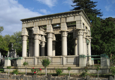
... granite piers which create porch spaces leading to the entrance ways. Two variegated Port Jackson Figs are planted at either end. ... How is it significant? Boroondara Cemetery is of aesthetic, architectural, scientific (botanical) and historical significance to the State of Victoria. ... ... cemetery boroondara kew gatehouse clock tower clocktower heritage memorial Digital image of the Syme memorial in Boroondara Cemetery, Kew. ...The Boroondara General Cemetery is registered by Heritage VictoriaFrom Heritage Victoria Statement of Significance Last updated on - December 15, 2005 (undated change to citation made since 2005) What is significant? Boroondara Cemetery, established in 1858, is within an unusual triangular reserve bounded by High Street, Park Hill Road and Victoria Park, Kew. The caretaker's lodge and administrative office (1860 designed by Charles Vickers, additions, 1866-1899 by Albert Purchas) form a picturesque two-storey brick structure with a slate roof and clock tower. A rotunda or shelter (1890, Albert Purchas) is located in the centre of the cemetery: this has an octagonal hipped roof with fish scale slates and a decorative brick base with a tessellated floor and timber seating. The cemetery is surrounded by a 2.7 metre high ornamental red brick wall (1895-96, Albert Purchas) with some sections of vertical iron palisades between brick pillars. Albert Purchas was a prominent Melbourne architect who was the Secretary of the Melbourne General Cemetery from 1852 to 1907 and Chairman of the Boroondara Cemetery Board of Trustees from 1867 to 1909. He made a significant contribution to the design of the Boroondara Cemetery. Boroondara Cemetery is an outstanding example of the Victorian Garden Cemetery movement in Victoria, retaining key elements of the style, despite overdevelopment which has obscured some of the paths and driveways. Elements of the style represented at Boroondara include an ornamental boundary fence, a system of curving paths which are kerbed and follow the site's natural contours, defined views, recreational facilities such as the rotunda, a landscaped park like setting, sectarian divisions for burials, impressive monuments, wrought and cast iron grave surrounds and exotic symbolic plantings. In the 1850s cemeteries were located on the periphery of populated areas because of concerns about diseases like cholera. They were designed to be attractive places for mourners and visitors to walk and contemplate. Typically cemeteries were arranged to keep religions separated and this tended to maintain links to places of origin, reflecting a migrant society. Other developments included cast iron entrance gates, built in 1889 to a design by Albert Purchas; a cemetery shelter or rotunda, built in 1890, which is a replica of one constructed in the Melbourne General Cemetery in the same year; an ornamental brick fence erected in 1896-99(?); the construction and operation of a terminus for a horse tram at the cemetery gates during 1887-1915; and the Springthorpe Memorial built between 1897 and 1907. ... ... The Syme Memorial (1908) is a memorial to David Syme, political economist and publisher of the Melbourne Age newspaper. The Egyptian memorial designed by architect Walter Richmond Butler is one of the most finely designed and executed pieces of monumental design in Melbourne. It has a temple like form with each column having a different capital detail. These support a cornice that curves both inwards and outwards. The tomb also has balustradings set between granite piers which create porch spaces leading to the entrance ways. Two variegated Port Jackson Figs are planted at either end. ... How is it significant? Boroondara Cemetery is of aesthetic, architectural, scientific (botanical) and historical significance to the State of Victoria. ... ...Digital image of the Syme memorial in Boroondara Cemetery, Kew. cemetery, boroondara, kew, gatehouse, clock, tower, clocktower, heritage, memorial -
Ballarat Heritage Services
Photograph - Australian Studio Pottery, Ceramic urn by Michael Wilson
... state and federal government clients as gifts to international dignitaries in Australia and overseas. Some time during this period, he took time out to obtain a Diploma of Business from the University of Ballarat. In 1996, he released a new dry glazed series of ceramics. In recent years, he has been working with bronze, aluminium, recycled copper, granite...state and federal government clients as gifts to international dignitaries in Australia and overseas. Some time during this period, he took time out to obtain a Diploma of Business from the University of Ballarat. In 1996, he released a new dry glazed series of ceramics. In recent years, he has been working with bronze, aluminium, recycled copper, granite ...Michael WILSON Michael Wilson receiveda Diploma of Fine Art in 1978 and a Graduate Diploma of Education in 1980 from the University of Ballarat (later Federation University). Establishing himself as a full-time potter, he made a range of hand-thrown functional wares with reduced glazes and hand-painted floral decoration featuring Australian native flowers. In 1989, he launched a line of gold lustre boxed ceramics targeted at the corporate gift market. These became popular with both corporate and state and federal government clients as gifts to international dignitaries in Australia and overseas. Some time during this period, he took time out to obtain a Diploma of Business from the University of Ballarat. In 1996, he released a new dry glazed series of ceramics. In recent years, he has been working with bronze, aluminium, recycled copper, granite, basalt, recycled red gum, sandstone and carved hebal blocks to produce a range of sculptures. Work may be marked with a painted 'Wilson' or impressed 'MW' in a flourished script or impressed 'MW' with a map of Australia. michael wilson, ceramics, australian studio pottery -
 Kew Historical Society Inc
Album - Photograph Album No.1, Henry Beater Christian, 1924-26
... State of Victoria, of what is now a distant point in time, and of places that have become radically altered through human intervention. henry beater christian (1886-1962) landscape photography photograph albums kew (vic.) — yarra river kew (vic.) — zig-zag bridge kew (vic.) — macauley’s boathouse studley park (vic.) — yarra river wonderland — grampians (vic.) black spur (vic.) marysville (vic.) maroondah dam (vic.) — construction warburton (vic.) cockatoo (vic.) bruthen (vic.) swan reach road (vic.) glen hills (vic.) lightning creek (vic.) omeo (vic.) glen wills (vic.) mt wills (vic.) sunnyside (vic) granite flat (vic.) toolangi (vic.) yea (vic ). flowerdale (vic.) mt white law (vic.) baw baw (vic.) christian-washfold collection Digital copy of a 47-page photograph album containing 255 gelatinous silver images, loaned by Diane Washfold with permission given to digitise and hold a copy in our collection. ...Henry Christian (c.1809-91), the grandfather of the photographer, was one of the first settlers in Kew. He arrived in Victoria with his wife Agnes and son Orlando in 1855 on the Gypsy Queen. He established a rope-making business in Bulleen Road by 1858 but was declared insolvent two years later. In his final years, he was celebrated as one of the oldest living settlers of the district. His son, Orlando Henry Beater Christian (c.1853-1930) became a member of the Hawthorn Band and a foundation member of the Willsmere Swimming Club. Orlando and his wife Elizabeth had four children of which Henry Beater Christian (1886-1962) was the oldest.An album of photographs, compiled by Henry Beater Christian (1886-1962) of Pakington Street, Kew, depicting individuals, natural and settled environments and the interactions between these worlds. Henry Christian, was a keen explorer, not just of his immediate environment but also of the Victorian wilderness. His major opus is contained in two albums in which he records, sometimes in majestic detail and on other occasions the intimate features of the natural world. His photographic travels during the 1920s, often in solitary ramblings but on other occasions with companions, recall the heroic landscape photography of an earlier era, pioneered by Nicholas Caire. In addition to their aesthetic value, the albums are historically significant records within the State of Victoria, of what is now a distant point in time, and of places that have become radically altered through human intervention.Digital copy of a 47-page photograph album containing 255 gelatinous silver images, loaned by Diane Washfold with permission given to digitise and hold a copy in our collection. The album contains a groups of photographic positives taken by Henry B Christian (a resident of Pakington Street), of places in Kew and throughout regional Victoria during the 1920s. The mainly sepia photographs, while small, are of a high quality. Photographs are typically lightly glued onto pages. Locations are frequently identified by white or black ink, which in a number of cases is illegible due to wear. Readable named locations include: Kew, the Grampians, Marysville, Baw Baw, Daylesford, Hepburn Springs, Bruthen, Swan Reach, Yea, Flowerdale, Port Fairy, Cockatoo, etc.henry beater christian (1886-1962), landscape photography, photograph albums, kew (vic.) — yarra river, kew (vic.) — zig-zag bridge, kew (vic.) — macauley’s boathouse, studley park (vic.) — yarra river, wonderland — grampians (vic.), black spur (vic.), marysville (vic.), maroondah dam (vic.) — construction, warburton (vic.), cockatoo (vic.), bruthen (vic.), swan reach road (vic.), glen hills (vic.), lightning creek (vic.), omeo (vic.), glen wills (vic.), mt wills (vic.), sunnyside (vic), granite flat (vic.), toolangi (vic.), yea (vic, )., flowerdale (vic.), mt white law (vic.), baw baw (vic.), christian-washfold collection -
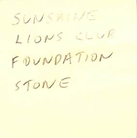 Sunshine and District Historical Society Incorporated
Plaque - Sunshine Lions Club House Of Lions Foundation Stone, 1958
... state of disrepair of the structure. During the demolishing of building, the foundation stone and a time capsule from was recovered. Sunshine Lions Club Corio Street Watt Street Sunshine Granite foundation stone Plaque Sunshine Lions Club House Of Lions Foundation Stone ...The Sunshine Lions Club built the Elderly Citizens Centre Watt Street corner of Corio Street, Sunshine. The building works started in 1958 and the Lions District Governor Bill Burge Phillips laid the foundation stone and time capsule on the 12th February 1958. The building was opened by Victoria's Minister for Health, Ewen Paul Cameron MLC on the 4th March 1959. This building which served the Elderly community of Sunshine and its district for nearly 50 years. The building was subsequently sold to a church group and in 2026 the building was demolished due to the state of disrepair of the structure. During the demolishing of building, the foundation stone and a time capsule from was recovered. Granite foundation stonesunshine lions club, corio street, watt street, sunshine