Showing 30 items matching "grenville county"
-
 Federation University Historical Collection
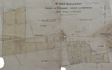
Map, No 6185 Ballaarat Parish of Ballaarat County of Grenville, not dated
... No 6185 Ballaarat Parish of Ballaarat County of Grenville......grenville county...map parish of ballaarat grenville county sebastopol central company engine house wesleyan reserve victoria street yarrowee street charlotte st kyle street Printed map with pencil inscriptions No 6185 Ballaarat Parish of Ballaarat County of Grenville Map Map ...Printed map with pencil inscriptionsmap, parish of ballaarat, grenville county, sebastopol, central company engine house, wesleyan reserve, victoria street, yarrowee street, charlotte st, kyle street -
 Federation University Historical Collection
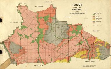
Plan, Haddon, County of Grenville, 1887, 1889
... Haddon, County of Grenville, 1887...Geological Map of Haddon in the County of Grenville surveyed by Ferdinand Krause. ...Haddon, County of Grenville, 1887 Plan Plan Ferdinand M. Krause Crown Lands Department Melbourne Ferdinand M. ...Ferdinand Krause taught at the Ballarat School of MinesGeological Map of Haddon in the County of Grenville surveyed by Ferdinand Krause. haddon, grenville, krause, ferdinand krause, cgt, lake burrumbeet, windermere, chepstowe, bailies creek, snake valley lead, nentingbool preemptice right, cardigan state forest, haddon state forest -
 Federation University Historical Collection
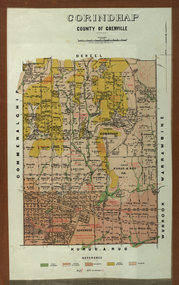
Plan - Parish Plan, Corindhap, County of Grenville, 1898
... Corindhap, County of Grenville...Colour Parish Plan of Corindhap, County of Grenville, and a report on the Parish....Maw Wallace Douglas John Moffatt Colour Parish Plan of Corindhap, County of Grenville, and a report on the Parish. Corindhap, County of Grenville Plan Parish Plan ...Colour Parish Plan of Corindhap, County of Grenville, and a report on the Parish.corindhap, dereel, warrambine, kuracaruc, commeralghip, rokewood, kuruc-a-ruc, w. elder, william elder, john thornly, robert cullen, davis aitcheson, robert gidney, john elder, w. barnard, anton trende, thomas hill, george hobson, h. reynolds, john collins, ironstone quarry, john jacka, patrick shanahan, murdoch mclennon, kaolinitic clay, kaolin, james holt, mary a. palmer, isaac everett, james mooney, michael cahill, fred benjamin, george hopkins, david houghton, john quarrell, j. camm, james macdonald, john thornley, break of day gully, john wilson, thomas middleton, alexander mcpherson, joseph coldwell, h. brand, pereverance co, puddling mils, mary a. stanbrook, c.w. stanbrook, eliza byrnes, james byrnes, j. maw, wallace douglas, john moffatt -
 Federation University Historical Collection
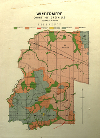
Map, Windermere, County of Grenville
... Windermere, County of Grenville...Coloured geological map of Windermere, County of Grenville. Scale is 40 chains to 1 inch...windermere grenville krause plan map Coloured geological map of Windermere, County of Grenville. ...Coloured geological map of Windermere, County of Grenville. Scale is 40 chains to 1 inchwindermere, grenville, krause, plan, map -
 Federation University Historical Collection
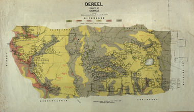
Map, Dereel, County of Grenville, 1890, 1890
... Dereel, County of Grenville, 1890...Geological map of Dereel in the County of Grenville featuing six colours (predominantly grey and yellow). ...Dereel is in western Victoria. dereel ferdinand krause crown lands department plan Geological map of Dereel in the County of Grenville featuing six colours (predominantly grey and yellow). ...Dereel is in western Victoria.Geological map of Dereel in the County of Grenville featuing six colours (predominantly grey and yellow). WGS 84 Centroid Lat: 37 degrees 48 feet 50 inches S Long:143 degrees 42 feet 10 inches S N-S: 6.4 km E-W: 15.2 km dereel, ferdinand krause, crown lands department, plan -
 Federation University Historical Collection
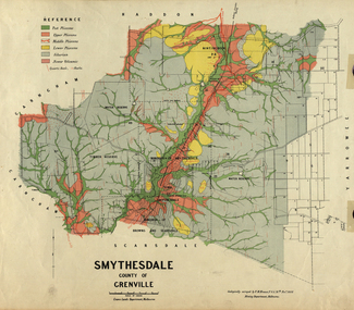
Map, Smythesdale, County of Grenville, 1888, 1889
... Smythesdale, County of Grenville, 1888...Coloured map of the County of Grenville. The edge has been taped. The scale is 40 chains to 1 inch. ...Smythesdale, County of Grenville, 1888 Map Ferdinand M. Krause ...The map maker, Ferdinand M. Krause, was a professor at the Ballarat School of Mines. This land was printed form the Crown Lands Department, Melbourne. Coloured map of the County of Grenville. The edge has been taped. The scale is 40 chains to 1 inch. The map is accompanied with a foolscap sheet printed by the Mines Department in 1898. It is a Report on the Parish of Smythesdale by F.M. Krause and includes information on the water reserve, worked quartz veins, Watson's Hill, Surface Hill and Sugarloaf Hill, Haddon, Trunk Lead and the Crucible Shaft. smythesdale, krause, f.m. krause, ferdinand krause, nitingbool, watson's hill, surface hill, sugarloaf hill, haddon -
 Federation University Historical Collection
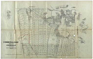
Plan, Commeralghip, County of Grenville, 1905, 03/02/1905
... Commeralghip, County of Grenville, 1905...Plan of allotments in Commeralghip, County of Grenville, Victoria. The plan includes the township of Kaleno, Dereel Pre-Emptice Right (John Cullen), Commeralghip Pre-Emptive Right (John Gordon McMillan and Glenfine Pre-Emptive Right (William Rowe). ...Gift of the Squire Family, 2014 Commeralghip, County of Grenville, 1905 Plan Plan ...The Township of Kaleno is in the Pitfield Plains. The Cape Clear Cemetery T contains the graves of miners and local pioneering families from the Cape Clear, Hollybush, Kaleno, Pitfield Plains, Pitfield, Illabarook, Berringa, Springdallah, Wallinduc, Glenfine, Happy Valley and Western Creek districts.Plan of allotments in Commeralghip, County of Grenville, Victoria. The plan includes the township of Kaleno, Dereel Pre-Emptice Right (John Cullen), Commeralghip Pre-Emptive Right (John Gordon McMillan and Glenfine Pre-Emptive Right (William Rowe). It also includes landholders such as Robert mcPherson, C. Cameron. John Boyd, John Cullen, W.T. Rowe, George Currie, J.P. Mackay, T. McCaffery, G. Hawkins, Alexander McPherson, C. Cameron. Gift of the Squire Family, 2014commeralghip, pitfield plains, kaleno, dereel, glenfine, squire, richard squire, w.t. rowe, john cullen, alexander mcpherson, george currie, mt misery, william rowe, mindai, john gordon mcmillan -
 Federation University Historical Collection
Plan, Crown Lands Department Melbourne, Parish of Clarkesdale, County of Grenville
... Parish of Clarkesdale, County of Grenville...Parish of Clarkesdale, County of Grenville Plan Crown Lands Department Melbourne ...Geolgical plan.clarkesdake, berringa, staffordshire reef, piggoreet -
 Federation University Historical Collection
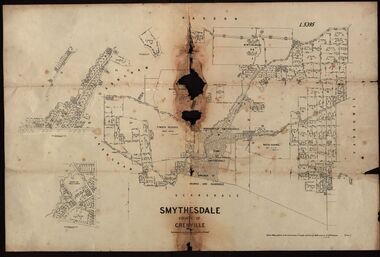
Plan, Smythesdale, County of Grenville, 01/12/1892
... Smythesdale, County of Grenville...Gift of the Squire Family smythesdale scarsdale browns yarrowee carngham samuel barlett sheridan wrigley p. land r. simpson d. davis nintingbool mclachlan a. mclachlan c. taylor w. c. smith d. davies w. williams m. jones t. mcgurk r. selkirk a. mooney A plan showing the Borough of Smythesdale, Smythesdale, Browns and Scarsdale, allotments, water reserve, Timber reserve, Nintingbool Pre-emptive Right, Reserve for public gardens, Reserve for Cricket Ground, Reserve for Reservoir Smythesdale, County of Grenville Plan Department of Lands and Survey T.F. ...This plan is associated with former Ballarat School of Mines Student Richard Squire (1875-1876). Gift of the Squire FamilyA plan showing the Borough of Smythesdale, Smythesdale, Browns and Scarsdale, allotments, water reserve, Timber reserve, Nintingbool Pre-emptive Right, Reserve for public gardens, Reserve for Cricket Ground, Reserve for Reservoirsmythesdale, scarsdale, browns, yarrowee, carngham, samuel barlett, sheridan, wrigley, p. land, r. simpson, d. davis, nintingbool, mclachlan, a. mclachlan, c. taylor, w. c. smith, d. davies, w. williams, m. jones, t. mcgurk, r. selkirk, a. mooney -
 Federation University Historical Collection
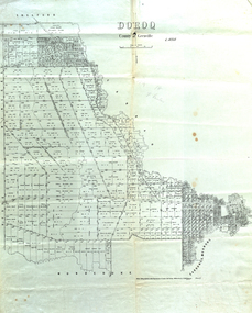
Map, Doroq County of Grenville L4935, 1911, 28 June 1911
... Doroq County of Grenville L4935, 1911...Holland, Robert Morrison Doroq County of Grenville L4935, 1911 Map Map ...This plan is associated with former Ballarat School of Mines Student Richard Squire (1875-1876). Gift of the Squire FamilyParish Plan of Doroq in black ink printed on cream paper. It includes the township of Inverleigh and Barwon Rover. Some of the names on the plan are William McRobie, William MacRobie, Thomas Russell, W.C. Smith, John Bell, J. Moffatt, Thomas Moffatt, John Anderson, George Synnot, Charles Lloyd, William MacRobie, J. Flack, Alexander Campell, T. Maher, William Berthon. Thomas Jewell, James Carstairs, D. MCInnerney, F.H. Holland, Robert Morrison17 7/9 18 9 miles handwritten in pencil Photo lithographed at the Department of Lands and Survey Melbourne by T. E. McGauran 28.6.11 Price 1/-carrunge-murnong, murdeduke, carrah, shelford, inverleigh, barwon river, hesse, wingeel, george russell, george russell's pre-emptive section, john moffatt, w. c. smith, macrobie, john bell, thomas russell, t.f. mcgauran -
 Federation University Historical Collection
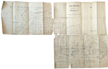
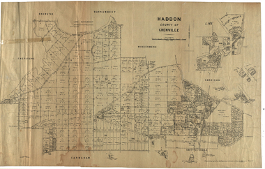
Plan, Haddon County of Grenville, 1887, 1887
... Haddon County of Grenville, 1887...Rennie Haddon County of Grenville, 1887 Plan Department of Lands and Survey J. ...Parish Plan of Haddon showing the township of Haddon, Cardigan and Haddon State Forest, Lake Burrumbeet and Nentingbook Pre-emptive Right. Names on the allotments include H. Cuthbert, B. Hepburn, T.W. Lloyd, J. Palmer, E.A. Wynne, William Collard Smith, A. Porteous, P. Russell, J. Mitchell, G. Renniehandwritten 'J. H. Cunningham Applic'haddon, cardigan, haddon state forest, lake burrumbeet, nentingbook pre-emptive right, h. cuthbert, b. hepburn, t.w. lloyd, j. palmer, e.a. wynne, william collard smith, a. porteous, p. russell, j. mitchell, g. rennie, j. noone, department of lands and survey -
 Friends of Ballarat Botanical Gardens History Group
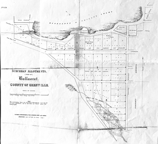
Work on paper - Suburban Allotments (west of) Ballaarat, Wendouree or Yuille's Swamp, County of Grenville 30/4/1856, 30/4/1856. No date given for photocopy
... Wendouree or Yuille's Swamp, County of Grenville 30/4/1856......County of Grenville...Wendouree or Yuille's Swamp, County of Grenville 30/4/1856 Work on paper Suburban Allotments (west of) Ballaarat ...This map of the 1856 survey shows the numbered suburban allotments and the boundaries surrounding this area including Wendouree or Yuilles's Swamp close to where the Ballarat Botanical Gardens and the Lake exist today. This map gives a clear idea of an early survey of this western area and directions to areas of Ballarat surrounding these allotments.2 pages of the same map, except p.2 shows the Township Reserve on the lefthand side of the page. On the back of p.2, righthand corner is the Public Records Stamp.P2, righthand corner is the citation in pencil.john garner, doctor john garner, ballarat botanical gardens, friends of ballarat botanical gardens, map of western suburban allotments 1856, county of grenville, public record office of victoria, john garner collection, gardens, ballarat -
 Federation University Historical Collection
Plan, Haddon, County of Grenville, 1932, 13/04/1932
... Haddon, County of Grenville, 1932...haddon grenville cardigan water supply reserve nentingbook pre-emptive right a. mclachlan lake burrumbeet e.a. wynne p. russell b. hepburn benjamin hepburn nentingbool t.c. wilson j. amoy william collard smith james roach j. mitchell The Haddon Parish Plan shows crown parcels government roads, Crown Reserves, Railway. Scale 40 chains to 1" (1:31, 680) WGS 84 Centroid Lat: 37 degrees 34' 00" S Long: 148 degrees 40' 20" E N.S. 9.3km E.W.: 16.1km Haddon, County ...The Haddon Parish Plan shows crown parcels government roads, Crown Reserves, Railway. Scale 40 chains to 1" (1:31, 680) WGS 84 Centroid Lat: 37 degrees 34' 00" S Long: 148 degrees 40' 20" E N.S. 9.3km E.W.: 16.1kmhaddon, grenville, cardigan, water supply reserve, nentingbook pre-emptive right, a. mclachlan, lake burrumbeet, e.a. wynne, p. russell, b. hepburn, benjamin hepburn, nentingbool, t.c. wilson, j. amoy, william collard smith, james roach, j. mitchell -
 Federation University Historical Collection
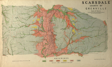
Plan, Scarsdale County of Grenville, 1889, 26/01/1889
... Scarsdale County of Grenville, 1889...scarsdale grenville krause browns and scarsdale mopianimum watershed yarrowee woady yalloak timber reserve department of mines plans cgt crown lands Ferdinand Krause Rectangular plan of a geological survey edged in masking tape. It is predominantly grey, pink and green, but has some yellow. scale is 40 chains to one inch. (see Cat. No. 1098 for report on the Parish of Scarsdale) Scarsdale County ...Rectangular plan of a geological survey edged in masking tape. It is predominantly grey, pink and green, but has some yellow. scale is 40 chains to one inch. (see Cat. No. 1098 for report on the Parish of Scarsdale)scarsdale, grenville, krause, browns and scarsdale, mopianimum, watershed, yarrowee, woady yalloak, timber reserve, department of mines, plans, cgt, crown lands, ferdinand krause -
 Federation University Historical Collection
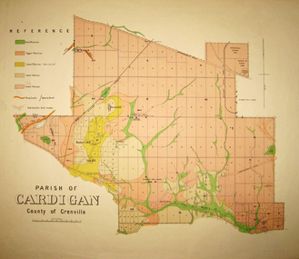
Map - Geological survey, Parish of Cardigan, County of Grenville, c1889
... Parish of Cardigan, County of Grenville...Parish of Cardigan, County of Grenville Map Geological survey ...Geological map of the Parish of Cardigan on a cadastral base showing quartz reefs, shafts, alluvial deposits.cardigan, winter's creek, ballarat cattle yards railway, prince of wales park, ballarat, friendly societies reserve, ballarat industrial school reserve, green hill, bunker's hill, sago hill, diamond drill bores, cardigan propriety, half way house, ti tree creek, albion consols, prince imperial, winter's freehold company -
 Federation University Historical Collection
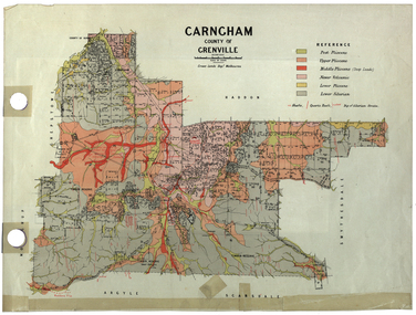
Plan, Carngham, County of Grenville
... Carngham, County of Grenville......county of grenville...Carngham, County of Grenville Plan Plan Crown Lands Department Melbourne ...A plan of Carngham, Victoria.snake valley, timber reserve, poverty point, recreation reserve, carngham, county of ripon, county of grenville, plan -
 Federation University Historical Collection
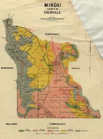
Plan, Mindai County of Grenville
... Mindai County of Grenville...plan geology mindai pitfiled plains old pitfield plains william mckay g. curie l. lowe d. mcnaught grand trunk lead patrick shelton Plan of MIndai showing geological eras. Mindai County of Grenville Plan Plan ...Plan of MIndai showing geological eras.plan, geology, mindai, pitfiled plains, old pitfield plains, william mckay, g. curie, l. lowe, d. mcnaught, grand trunk lead, patrick shelton -
 Federation University Historical Collection
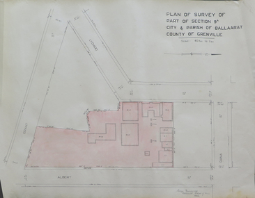
Plan, Plan of Survey of Part of Section 9A City & Parish of Ballarat County of Grenville (Albert Street frontage), 1932
... Plan of Survey of Part of Section 9A City & Parish of Ballarat County of Grenville (Albert Street frontage)...Hand written page by George Murrowood, of technical description of land surveying Grade II 1932 Plan of Survey of Part of Section 9A City & Parish of Ballarat County of Grenville (Albert Street frontage) Plan Plan George Murrowood ...The M.B. John Trade Building was built on the Albert Street Frontage.1. Plan of SMB showing Albert, Grant, Lydiard and Dana streets, on paper with colored highlights undertaken by Ballarat School of Mines student George Murrowood in 1932 2. Hand written page by George Murrowood, of technical description of land surveying Grade II 1932ballarat school of mines, surveying, george murrowood, albert street, alumni, m.b. john building, architectural plan -
 Federation University Historical Collection
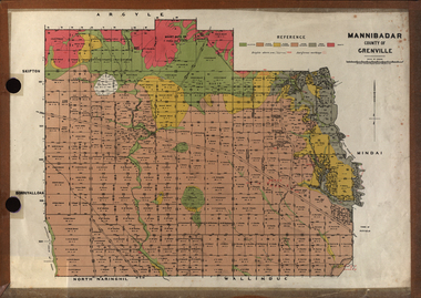
Plan, Mannibadar Geological plan
... Coloured plan of Mannibadar, County of Grenville....Barker Library (top floor) Mount Helen goldfields mannibadar pitfield mount bute emu hills woady yalouk river geology plan Coloured plan of Mannibadar, County of Grenville. Mannibadar Geological plan Plan Crown Lands Department ...Coloured plan of Mannibadar, County of Grenville.mannibadar, pitfield, mount bute, emu hills, woady yalouk river, geology, plan -
 Federation University Historical Collection
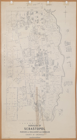
Plan, Borough of Sebastopol, 1940, 01/07/1940
... Plan showing the streets, allotments creeks in the Borough of Sebastopol, Parishes of Ballaarat and Cardigan, County of Grenville, in 1940. ...Barker Library (top floor) Mount Helen goldfields Sebastopol became a suburb of the City of Ballarat. sebastopol t. rider yarrowee creek leigh river St George's Reserve Leigh Creek Sebastopol Public Gardens Sebastopol Recreation Reserve Gravel reserve Night Soil Depot Sanitary depot Rubbish depot Plan showing the streets, allotments creeks in the Borough of Sebastopol, Parishes of Ballaarat and Cardigan, County of Grenville, in 1940. Borough of Sebastopol, 1940 Plan Plan ...Sebastopol became a suburb of the City of Ballarat.Plan showing the streets, allotments creeks in the Borough of Sebastopol, Parishes of Ballaarat and Cardigan, County of Grenville, in 1940. sebastopol, t. rider, yarrowee creek, leigh river, st george's reserve, leigh creek, sebastopol public gardens, sebastopol recreation reserve, gravel reserve, night soil depot, sanitary depot, rubbish depot -
 Old Colonists' Association of Ballarat Inc.
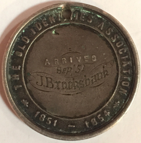
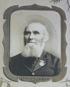
Photograph - Photograph - Colour, John Brooksbank's Old Identities' medal
... Brooksbank's hotel in 1860: "JAMES ODDIE & CO. have received instructions from the Mortgagees, to sell I by auction at their rooms, Dana street, on Thursday, 20th September, at twelve o'clock, All that desirable properly known as the , Halfway House Hotel, Together with all that piece or parcel of ' land situate in the parish of Cardigan and county of Grenville, containing 34 acres 1 rood 26 ½ perches, part of allotment 1, section 6, of said parish, situated on the Ballarat and Smythesdale road, and recently occupied by Mr J. ...Brooksbank's hotel in 1860: "JAMES ODDIE & CO. have received instructions from the Mortgagees, to sell I by auction at their rooms, Dana street, on Thursday, 20th September, at twelve o'clock, All that desirable properly known as the , Halfway House Hotel, Together with all that piece or parcel of ' land situate in the parish of Cardigan and county of Grenville, containing 34 acres 1 rood 26 ½ perches, part of allotment 1, section 6, of said parish, situated on the Ballarat and Smythesdale road, and recently occupied by Mr J. ...The Old Identities' Association was a forerunner of the Old Colonists' Association Ballarat. John Brooksbank was a very early arrival to Ballarat in September 1851, which was not long after the discovery of gold at Ballarat. J. Brooksbank lost a dog in 1857 "LOST from the Half Way House, Smythe's Creek Road, a black bloodhound and kangaroo dog. Anyone detaining him after this date will be prosecuted. J. BROOKSBANK" (Ballarat Star, 30 December 1857) Another very early identity in Ballarat, James Oddie, advertised the sale of J. Brooksbank's hotel in 1860: "JAMES ODDIE & CO. have received instructions from the Mortgagees, to sell I by auction at their rooms, Dana street, on Thursday, 20th September, at twelve o'clock, All that desirable properly known as the , Halfway House Hotel, Together with all that piece or parcel of ' land situate in the parish of Cardigan and county of Grenville, containing 34 acres 1 rood 26 ½ perches, part of allotment 1, section 6, of said parish, situated on the Ballarat and Smythesdale road, and recently occupied by Mr J. Brooksbank. The property consists of a spacious stone building one story high, strong and substantially built, the internal fittings and arrangements are neat and complete. The house possesses all requisite accommodation for a respectable country hotel. In addition are stockyards, stables &c, all well and securely fenced. Terms at Sale. (Ballarat Star, 20 September 1860) Four years later Brookbank was selling his hotel in Lyons Street Ballarat: "RARE OPPORTUNITY.-FOR SALE the BLACK BULL HOTEL, Lyons street. The proprietor of the above hotel being about entering into another line of business, begs to call the attention of parties looking for a safe and profitable investment, the above having undergone thorough repairs, and is now in good working order and doing a fair share of business. The conditions will, be half cash, balance six, nine, and twelve months. Apply, J. Brooksbank, proprietor, on the premises. (Ballarat Star, 22 October 1864)Colour photograph of a sterling silver medal relating to The Old Identities' Association 1851-1854. The medallion, belonging to John Brooksbank, has a drilled hole at the top suggesting it was worn by the owner at some stage in its life. The medal has been engraved: Arrived "Sep 51 J. Brooksbankold identities association, old colonists' association ballarat, c.a. welch, silversmith, numismatics, j. brooksbank, medal -
 Old Colonists' Association of Ballarat Inc.
Photograph - Photograph - Black and White, John Brooksbank
... Brooksbank's hotel in 1860: "JAMES ODDIE & CO. have received instructions from the Mortgagees, to sell I by auction at their rooms, Dana street, on Thursday, 20th September, at twelve o'clock, All that desirable properly known as the , Halfway House Hotel, Together with all that piece or parcel of ' land situate in the parish of Cardigan and county of Grenville, containing 34 acres 1 rood 26 ½ perches, part of allotment 1, section 6, of said parish, situated on the Ballarat and Smythesdale road, and recently occupied by Mr J. ...Brooksbank's hotel in 1860: "JAMES ODDIE & CO. have received instructions from the Mortgagees, to sell I by auction at their rooms, Dana street, on Thursday, 20th September, at twelve o'clock, All that desirable properly known as the , Halfway House Hotel, Together with all that piece or parcel of ' land situate in the parish of Cardigan and county of Grenville, containing 34 acres 1 rood 26 ½ perches, part of allotment 1, section 6, of said parish, situated on the Ballarat and Smythesdale road, and recently occupied by Mr J. ...The Old Identities' Association was a forerunner of the Old Colonists' Association Ballarat. John Brooksbank was a very early arrival to Ballarat in September 1851, which was not long after the discovery of gold at Ballarat. J. Brooksbank lost a dog in 1857 "LOST from the Half Way House, Smythe's Creek Road, a black bloodhound and kangaroo dog. Anyone detaining him after this date will be prosecuted. J. BROOKSBANK" (Ballarat Star, 30 December 1857) Another very early identity in Ballarat, James Oddie, advertised the sale of J. Brooksbank's hotel in 1860: "JAMES ODDIE & CO. have received instructions from the Mortgagees, to sell I by auction at their rooms, Dana street, on Thursday, 20th September, at twelve o'clock, All that desirable properly known as the , Halfway House Hotel, Together with all that piece or parcel of ' land situate in the parish of Cardigan and county of Grenville, containing 34 acres 1 rood 26 ½ perches, part of allotment 1, section 6, of said parish, situated on the Ballarat and Smythesdale road, and recently occupied by Mr J. Brooksbank. The property consists of a spacious stone building one story high, strong and substantially built, the internal fittings and arrangements are neat and complete. The house possesses all requisite accommodation for a respectable country hotel. In addition are stockyards, stables &c, all well and securely fenced. Terms at Sale. (Ballarat Star, 20 September 1860) Four years later Brookbank was selling his hotel in Lyons Street Ballarat: "RARE OPPORTUNITY.-FOR SALE the BLACK BULL HOTEL, Lyons street. The proprietor of the above hotel being about entering into another line of business, begs to call the attention of parties looking for a safe and profitable investment, the above having undergone thorough repairs, and is now in good working order and doing a fair share of business. The conditions will, be half cash, balance six, nine, and twelve months. Apply, J. Brooksbank, proprietor, on the premises. (Ballarat Star, 22 October 1864)Photographic portrait of John Brooksbank from a photographic montage held by the Ballarat Old Colonists' Association.john brooksbank, ballarat old colonists' association, ballarat old colonists' club, old colonists' association -
 Ballarat Heritage Services
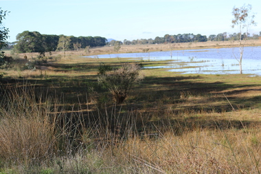
Photograph - Digital photograph, Dorothy Wickham, Winter's Swamp, Ballarat, January to April 2014
... Winter Swamp LAT -37 32 LONG 143 47, Parish of Dowling Forest, County of Grenville Winter Swamp, on the southwest corner of Ballarat West Town Common, was not included in the original proclamation of the Common in 1861. ...Winter Swamp LAT -37 32 LONG 143 47, Parish of Dowling Forest, County of Grenville Winter Swamp, on the southwest corner of Ballarat West Town Common, was not included in the original proclamation of the Common in 1861. ...Study of Winter's Swamp commissioned by BEN and completed by BHS. The swamp was named after one of the first European settlers in the district. Winter Swamp LAT -37 32 LONG 143 47, Parish of Dowling Forest, County of Grenville Winter Swamp, on the southwest corner of Ballarat West Town Common, was not included in the original proclamation of the Common in 1861. However, being marshland, it was not considered suitable for grazing, so was added to the Common soon after 1861. Winter Swamp is a large wetland with native and exotic pasture significant for wildlife. John Winter (Jock) was born in Berwickshire, Scotland. He married Janet Margaret Irving the daughter of Robert Irving, advocate, Bonshaw, Dumfries, Scotland. Winter died in Ballarat in 1875 and was buried at the Ballaarat Old Cemetery. He took up the run Bonshaw from 1841; Leigh River Buninyong 1842-46; Junction, Delatite, March 1851 to September 1862; with sons: Carag Carag and Corop, April 1857 to September 1872; Colbinabbin and Stewart’s Plains, April 1857 to December 1872; St Germains February 1867 to March 1871. (The name became Winter-Irving in 1890). Mr John Winter, who died on August 22 at the age of 72, was a man of some note it the mining community of Ballarat. He was a self-made man, and one of our oldest colonists, it being over a quarter of a century age since he took up county about Ballarat and settled at Bonshaw. He died very rich. It is calculated that if he had retained an interest in all his runs, his income must have been not less than £10,000 or £50,000 a year. Some eight or ten years ago he sold his Bonshaw pre-emption to the Bonshaw Gold mining Company for £20,000, and a few years later the ground belonging now to Winter's Freehold Company brought him £50,000 more, the payment being made at the requisition of the deceased in sovereigns. In these relations Mr. Winter has been closely identified with the mining industry at Ballarat. The deceased was a native of Lauder, in Berwickshire, and landed in Victoria several years before the gold discovery.The principle task of this project was the delivery of a report outlining the history of European settlement in the Skipton and Cardigan/Ballarat districts as pertinent to the use of and impact on the natural environment of the two reserves Skipton Common and Winter Swamp. The report was delivered in digital form only. The report, upon completion, was presented to the Network’s Committee in order to discuss the project. The report identified and described the uses of Skipton Common and Winter Swamp, and their impacts. In particular, this report examined farming/grazing (official and informal), mining, vegetation removal (including the removal of woodlands for timber, grasslands for pasture improvement) & use of riparian areas for access to water and timber removal. Recording the more benign and environmentally friendly uses such as picnicking, community activities, nature walks and the roles of organisations such as Field Naturalists’ and Bird Observers’ clubs, school and scout/guide groups will be relevant in helping to depict overall community attitudes towards the reserves; e.g.: has the Common generally been viewed as little more than a grazing paddock and fire hazard; has Winter Swamp always been the unknown natural asset that seems to have been its lot for at least the past 40 years? In this regard, the more contemporary history of actions surrounding the use and management of the reserves is of particular interest, in view of the extant evidence at both reserves; e.g. the actions of the Shire of Ballarat in the 1980s in establishing Winter Swamp as something of a competitor to Lake Wendouree but with a more environmental bent (although almost none of the plants used are indigenous species, but that is part of the story); the trotting track constructed on Skipton Common in the 1960s following representations to Premier Henry Bolte and the cropping of the western section of the Common to raise funds for the town’s new swimming pool, the fertilizing of the land putting an end to the native grassland vegetation. There are obviously multiple sources of information to source in preparing the report, however sources that the contractor is specifically requested to consult are the Skipton Historical Society, the former Skipton Common managers (specifically Graeme Pett), the Cardigan Windermere Landcare Group and the Learmonth Historical Society (believed to hold many of the former Shire of Ballarat’s records pertaining to the Council’s role as the Committee of Management for both Winter Swamp and the Ballarat West Town Common – Winter Swamp was split between 2 separate Crown Land tenures). The contractor is also encouraged but not required to utilise community newsletters, such as the Skipton Community Newsletter, to publicise and seek information about the project. Skipton Historical Society (Mary Bradshaw) contacted on Thursday 12 June 2.30pm. Mary lived on a farm out of Skipton but is currently living in the township. She remembers walking along the creek of the Common especially in spring and autumn in bare feet and that it was a very pretty place. There were a few snakes around the waterway in summer. People put cows and a couple of horses on the commonage to graze. Graeme Pett has always lived close to the Common and would know a lot about it. Other possible contacts would be Nicole Petress, Secretary of the Progress Association, and the Corangamite Council, Camperdown. Digital images of Winter's Swampwinter's swamp, ballarat, john winter, ballarat environmental network, mullawullah -
 Federation University Historical Collection
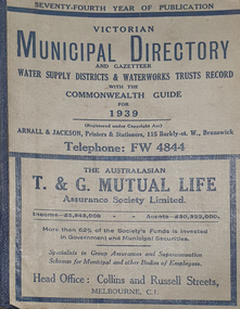
Book - Street Directory, Arnall & Jackson Pty Ltd, Victorian Municipal Directory and Gazatteer, 1939, 1939
... county court...crown lands and survey...Engine Drivers Board...Licensing Court...Sludge Abatement Board...Cities...towns...boroughs...Ballarat...Buninyong...Gordon...grenville...Victorian municipalities municipal councils water supply advertisements Aboriginal Protection Board Agriculture Charities county court crown lands and survey Engine Drivers Board Licensing Court Sludge Abatement Board Cities towns boroughs Ballarat Buninyong Gordon grenville Talbot Traralgon Ballaarat Happy Valley Bungaree Daylesford Glenlyon Glenlyon Shire Hepburn SPrings Beige cover with blue spine. 1052 pages. ...Beige cover with blue spine. 1052 pages. It includes an index to townships, parishes and Railway stations. non-fictionvictorian municipalities, municipal, councils, water supply, advertisements, aboriginal protection board, agriculture, charities, county court, crown lands and survey, engine drivers board, licensing court, sludge abatement board, cities, towns, boroughs, ballarat, buninyong, gordon, grenville, talbot, traralgon, ballaarat, happy valley, bungaree, daylesford, glenlyon, glenlyon shire, hepburn springs -
Federation University Historical Collection
Book - Directory, Arnall & Jackson Pty Ltd, Victorian Municipal Directory and Gazatteer, 1935, 1935
... county court...crown lands and survey...Engine Drivers Board...Licensing Court...Sludge Abatement Board...Cities...towns...boroughs...Ballarat...Buninyong...Gordon...grenville...Victorian municipalities municipal councils water supply advertisements Aboriginal Protection Board Agriculture Charities county court crown lands and survey Engine Drivers Board Licensing Court Sludge Abatement Board Cities towns boroughs Ballarat Buninyong Gordon grenville Talbot Traralgon Ballaarat Happy Valley Bungaree Daylesford Glenlyon Glenlyon Shire Hepburn SPrings Brown cover with maroon spine. 801 pages. ...Brown cover with maroon spine. 801 pages. It includes an index to townships, parishes and Railway stations. non-fictionvictorian municipalities, municipal, councils, water supply, advertisements, aboriginal protection board, agriculture, charities, county court, crown lands and survey, engine drivers board, licensing court, sludge abatement board, cities, towns, boroughs, ballarat, buninyong, gordon, grenville, talbot, traralgon, ballaarat, happy valley, bungaree, daylesford, glenlyon, glenlyon shire, hepburn springs -
Federation University Historical Collection
Book - Directory, Arnall & Jackson Pty Ltd, Victorian Municipal Directory and Gazatteer, 1924, 1924
... county court...crown lands and survey...Engine Drivers Board...Licensing Court...Sludge Abatement Board...Cities...towns...boroughs...Ballarat...Buninyong...Gordon...grenville...Victorian municipalities municipal councils water supply advertisements Aboriginal Protection Board Agriculture Charities county court crown lands and survey Engine Drivers Board Licensing Court Sludge Abatement Board Cities towns boroughs Ballarat Buninyong Gordon grenville Talbot Traralgon Ballaarat Happy Valley Bungaree Daylesford Glenlyon Glenlyon Shire Hepburn SPrings Brown cover with blue spine. 708 pages. ...Brown cover with blue spine. 708 pages. It includes an index to townships, parishes and Railway stations. non-fictionvictorian municipalities, municipal, councils, water supply, advertisements, aboriginal protection board, agriculture, charities, county court, crown lands and survey, engine drivers board, licensing court, sludge abatement board, cities, towns, boroughs, ballarat, buninyong, gordon, grenville, talbot, traralgon, ballaarat, happy valley, bungaree, daylesford, glenlyon, glenlyon shire, hepburn springs -
 Federation University Historical Collection
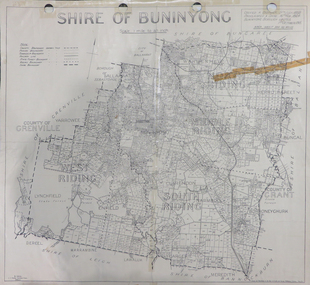
Map, Shire of Buninyong, c1970
... Barker Library (top floor) Mount Helen goldfields The Shire of Buninyong was located on the southern side of Ballarat. shire of buninyong buninyong clarendon narmbool enfield lychfield scotchman's navigators warrenheip scotsburn mt doran durham lead cambrian hill napoleons garibaldi mt clear lal lal bonshaw state forest elaine elaine north cargerie grenville mt mercer millbrook wallace yendon canadian kaolin deposits Mount Helen Campus .1) B.I.A.E., St Martin's, cemetery, mt Buninyong, mt Innes, rly stn Two maps of the Shire of Buninyong. .1) Map showing the County divisions, township boundaries, Railway line, State Forest boundary, riding boundary and shire boundary. ...The Shire of Buninyong was located on the southern side of Ballarat.Two maps of the Shire of Buninyong. .1) Map showing the County divisions, township boundaries, Railway line, State Forest boundary, riding boundary and shire boundary. Identifying words have been added in red and green texta. .2) Shire of Buninyong Parish Plan. Includes Buninyong, Clarendon, Narmbool, Enfield, Lychfield, SCotchman's, Navigators, Warrenheip, Scotsburn, mr Doran, Durham Lead, Cambrian Hill, Napoleons, Garibaldi, Mt Clear, Lal Lal, Bonshaw.1) B.I.A.E., St Martin's, cemetery, mt Buninyong, mt Innes, rly stn shire of buninyong, buninyong, clarendon, narmbool, enfield, lychfield, scotchman's, navigators, warrenheip, scotsburn, mt doran, durham lead, cambrian hill, napoleons, garibaldi, mt clear, lal lal, bonshaw, state forest, elaine, elaine north, cargerie, grenville, mt mercer, millbrook, wallace, yendon, canadian, kaolin deposits, mount helen campus -
 Federation University Historical Collection
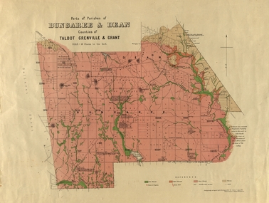
Plan, Bungaree and Dean Parish and Geological Plan, 1890, 07/1890
... Geological and Parish Map of parts of the Parishes of Bungaree and Dean in the Counties of Talbot, Grenville and Grant. The scale is 40 chains to one inch. ...Geological and Parish Map of parts of the Parishes of Bungaree and Dean in the Counties of Talbot, Grenville and Grant. The scale is 40 chains to one inch. ...Ferdinand M. Krause was a Professor at the Ballarat School of Mines.Geological and Parish Map of parts of the Parishes of Bungaree and Dean in the Counties of Talbot, Grenville and Grant. The scale is 40 chains to one inch. bungaree, deen, krause, f.m. krause, musk creek, clarkes hill, badger hill, beale's reservoir, acquainted. -
 Federation University Historical Collection
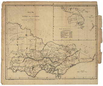
Map, Robert Brough Smyth, Sketch Map of the Colony of Victoria, c1871, c1872
... Barker Library (top floor) Mount Helen goldfields victoria victorian counties robert brough-smyth telegraph population bourke rodney dalhousie evelyn mornington buln-buln tanjil dargo delatite moira bogong bendigo gunbower grant talbot hampden heytesbury polwarth ripon kara-kara gladstone grenville croajingolong tambo benambra This map includes the population of each County in Victoria according to the 1871 Census, as well as the population of each Australian colony and New Zealand. ...This map includes the population of each County in Victoria according to the 1871 Census, as well as the population of each Australian colony and New Zealand. Telegraph Route is given in a detail at the top right. victoria, victorian counties, robert brough-smyth, telegraph, population, bourke, rodney, dalhousie, evelyn, mornington, buln-buln, tanjil, dargo, delatite, moira, bogong, bendigo, gunbower, grant, talbot, hampden, heytesbury, polwarth, ripon, kara-kara, gladstone, grenville, croajingolong, tambo, benambra -
 Federation University Historical Collection
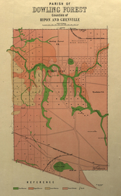
Plan, Parish of Dowling Forest, County of Ripon and Grenville, 19
... Parish of Dowling Forest, County of Ripon and Grenville...Parish of Dowling Forest, County of Ripon and Grenville Plan Department of Crown Lands and Survey ...Scale [1:31 680]. 40 chains to 1 in.Geological map on a cadastral base, showing the occurence of reefs, and alluvial deposits. Relief shown by contours.dowling forest, wyndholm, wyndholm pre-emptive right, miners rest, ballarat racecourse, winter's swamp, police reserve, miner's rest, winters swamp, geology