Showing 92 items matching "griffith island"
-
 Port Fairy Historical Society Museum and Archives
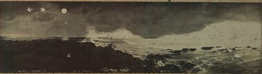
Photograph, Robert Scott, Griffith Island - Stormy Night
... Griffith Island - Stormy Night...Rare old photograph of a stormy night on Griffith Island...Black and white photograph of a stormy night on Griffith Island...Rocks on Griffith Island Port Fairy A Stormy night R.Scott photo...Griffith Island, Port Fairy, South West, Victoria, Australia...Port Fairy Historical Society Museum and Archives 30 Gipps Street Port Fairy great-ocean-road Rare old photograph of a stormy night on Griffith Island Rare photograph of a stormy night on Griffith Island taken with a standing camera beach sea seascape Rocks on Griffith Island Port Fairy A Stormy night R.Scott photo Black and white photograph of a stormy night on Griffith Island Griffith Island - Stormy Night Photograph Photograph Robert Scott ...Rare old photograph of a stormy night on Griffith IslandRare photograph of a stormy night on Griffith Island taken with a standing cameraBlack and white photograph of a stormy night on Griffith IslandRocks on Griffith Island Port Fairy A Stormy night R.Scott photobeach, sea, seascape -
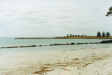
 Ballarat Heritage Services
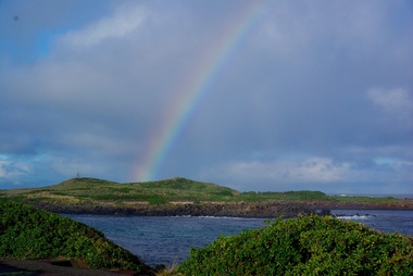
Digital photographs, L.J. Gervasoni, Griffith Island, Port Fairy, c2013
... Griffith Island, Port Fairy......griffith island...Colour photograph of Griffiths Island. ...Griffith Island, Port Fairy, Moyne Shire, Victoria, Australia...Ballarat Heritage Services PO Box 2209 Bakery Hill Post Office goldfields landscape port fairy beach waterscape moyne river griffith island rainbow weather Colour photograph of Griffiths Island. ...Colour photograph of Griffiths Island. landscape, port fairy, beach, waterscape, moyne river, griffith island, rainbow, weather -
 Port Fairy Historical Society Museum and Archives
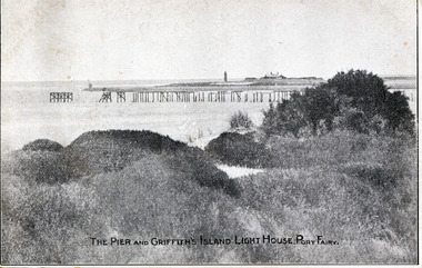
Postcard, Walker and Lugg, The Pier and Griffith island Lighthouse Port Fairy
... The Pier and Griffith island Lighthouse Port Fairy......griffith island...The Pier and Griffith island Lighthouse Port Fairy...The Pier and Griffith Island Lighthouse Port Fairy...Port Fairy Historical Society Museum and Archives 30 Gipps Street Port Fairy great-ocean-road The Pier and Griffith island Lighthouse Port Fairy pier jetty griffith island red lighthouse keepers cottages The Pier and Griffith Island Lighthouse Port Fairy plus photographic copy of black and white photograph of the remnants of the Campbell Street Pier with the lighthouse and its buildings in the background The Pier and Griffith island Lighthouse Port Fairy Postcard Postcard Walker and Lugg ...The Pier and Griffith island Lighthouse Port Fairyplus photographic copy of black and white photograph of the remnants of the Campbell Street Pier with the lighthouse and its buildings in the backgroundThe Pier and Griffith Island Lighthouse Port Fairypier, jetty, griffith island, red lighthouse, keepers cottages -
 Port Fairy Historical Society Museum and Archives
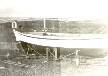
Photograph
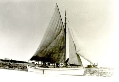
... ...griffith island...Black and white photograph of Bill Haldane standing with his boat Amaryllis as it nears completion on Griffith Island...Griffith Island, Port Fairy, South West, Victoria, Australia...She was requisitioned by the armed services during 1943 and did not return to Port Fairy. fish fishing boat industry amaryllis haldane w.h.haldane Bill haldane griffith island haldane brothers Black and white photograph of Bill Haldane standing with his boat Amaryllis as it nears completion on Griffith Island Photograph Photograph ...Amaryllis was the first fishing boat built by the Haldane Brothers in Port Fairy 1935. A well boat was on the Port Fairy register from 1936 -1943 in the name of W.H.Haldane. She was requisitioned by the armed services during 1943 and did not return to Port Fairy. Black and white photograph of Bill Haldane standing with his boat Amaryllis as it nears completion on Griffith Islandfish, fishing, boat, industry, amaryllis, haldane, w.h.haldane, bill haldane, griffith island, haldane brothers -
 Port Fairy Historical Society Museum and Archives
Photograph
... ...griffith island..."Amarylis" was built on Griffith Island by the Haldane Brothers when they were lighthouse keepers...Black and white photograph of Amaryllis with her coloured sails furled near the slipway on Griffith Island...Port Fairy Historical Society Museum and Archives 30 Gipps Street Port Fairy great-ocean-road "Amarylis" was built on Griffith Island by the Haldane Brothers when they were lighthouse keepers boat industry amaryllis Fishing shark couta griffith island Haldane bros Black and white photograph of Amaryllis with her coloured sails furled near the slipway on Griffith Island Photograph Photograph ..."Amarylis" was built on Griffith Island by the Haldane Brothers when they were lighthouse keepersBlack and white photograph of Amaryllis with her coloured sails furled near the slipway on Griffith Islandboat, industry, amaryllis, fishing, shark, couta, griffith island, haldane bros -
 Port Fairy Historical Society Museum and Archives
Postcard - Post Card, Looking towards the island Port Fairy
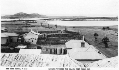
... ...Griffith island...black and white photograph taken from the mill looking towards Griffith Island....Port Fairy Historical Society Museum and Archives 30 Gipps Street Port Fairy great-ocean-road Looking towards the island Port Fairy town townscape river Griffith island south west passage causeway bridge span bridge Ocean sea wetland black and white photograph taken from the mill looking towards Griffith Island. ...Looking towards the island Port Fairyblack and white photograph taken from the mill looking towards Griffith Island.town, townscape, river, griffith island, south west passage, causeway bridge, span bridge, ocean, sea, wetland -
 Port Fairy Historical Society Museum and Archives
Photograph
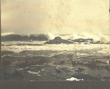
... "Breakers" - Griffith Island...The Breakers - Griffiths Island January 1906...Port Fairy Historical Society Museum and Archives 30 Gipps Street Port Fairy great-ocean-road "Breakers" - Griffith Island breakers griffiths island Sea ocean The Breakers - Griffiths Island January 1906 Photograph Photograph Photograph ..."Breakers" - Griffith IslandPhotographThe Breakers - Griffiths Island January 1906breakers, griffiths island, sea, ocean -
 Port Fairy Historical Society Museum and Archives
Postcard, The Rose Series / The Rose Stereographs, East Beach, Port Fairy Victoria
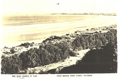
... ...griffith island...Black and white Photograph of East beach looking East South East with dunes in the foreground and the bay and Griffith Island in the background taken for use as a postcard...Port Fairy Historical Society Museum and Archives 30 Gipps Street Port Fairy great-ocean-road east beach Dunes sea ocean griffith island The Rose Series P.1144. Copyright East Beach Port Fairy Victoria Black and white Photograph of East beach looking East South East with dunes in the foreground and the bay and Griffith Island in the background taken for use as a postcard East Beach, Port Fairy Victoria Postcard Postcard The Rose Series / The Rose Stereographs ...Black and white Photograph of East beach looking East South East with dunes in the foreground and the bay and Griffith Island in the background taken for use as a postcardThe Rose Series P.1144. Copyright East Beach Port Fairy Victoriaeast beach, dunes, sea, ocean, griffith island -
 Port Fairy Historical Society Museum and Archives
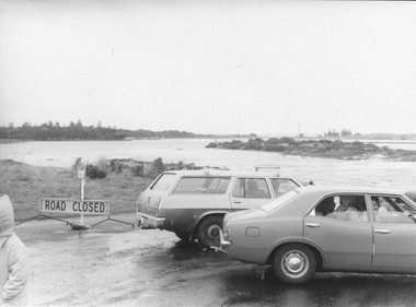
Photograph
... ...griffith island...Causeway over river to Griffith Island after storm 1975 . Southwest passage...Port Fairy Historical Society Museum and Archives 30 Gipps Street Port Fairy great-ocean-road Causeway over river to Griffith Island after storm 1975 . Southwest passage Southwest passage Causeway storm 1975 griffith island Causeway over river 16/05/1975 black and white photograph of Cars parked at causeway during storm Photograph Photograph ...Causeway over river to Griffith Island after storm 1975 . Southwest passageblack and white photograph of Cars parked at causeway during stormCauseway over river 16/05/1975southwest passage, causeway, storm, 1975, griffith island -
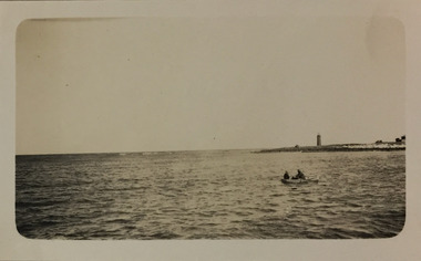 Kew Historical Society Inc
Photograph - Port Fairy Bay, c.1926
... ...Griffith Island...The scene is of Port Fairy Bay, with the Red lighthouse on Griffith Island on the horizon. In the foreground, two men are rowing a boat. ...The scene is of Port Fairy Bay, with the Red lighthouse on Griffith Island on the horizon. In the foreground, two men are rowing a boat. ...Henry Beater Christian (1886-1962) , was a descendant of one of the earliest settler families in Kew. Employed at the Kew Asylum as a 'public servant', he was a skilled amateur photographer, photographing numerous scenes in Kew and on his travels around Victoria. The majority of his photographs date from 1916 to 1929. His finest photographs are housed in two photograph albums. Digital copy of a photograph from page 23 of the 47-page photograph album containing 261 gelatinous silver images, loaned by Diane Washfold with permission given to digitise and hold a copy in our collection. In the 1920s, the photographer travelled throughout Victoria, including on the west coast from Port Campbell to Port Fairy. Trips were presumably made by train and by foot. Lynda Tieman and her team at the Port Fairy Historical Society were able to identify a number of Henry Christian's photographs of Port Fairy of which this is one. The scene is of Port Fairy Bay, with the Red lighthouse on Griffith Island on the horizon. In the foreground, two men are rowing a boat. henry beater christian (1886-1962), landscape photography, christian-washfold collection, photograph albums, port fairy bay, red lighthouse, griffith island -
 Port Fairy Historical Society Museum and Archives
Photograph
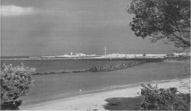
... Coloured photograph of Griffith Island with Norfolk Island Pines and remains of trolly wall...Port Fairy Historical Society Museum and Archives 30 Gipps Street Port Fairy great-ocean-road East Beach East beach battery hill reef training walls norfolk pines Coloured photograph of Griffith Island with Norfolk Island Pines and remains of trolly wall Photograph Photograph ...East BeachColoured photograph of Griffith Island with Norfolk Island Pines and remains of trolly walleast beach, battery hill, reef, training walls, norfolk pines -
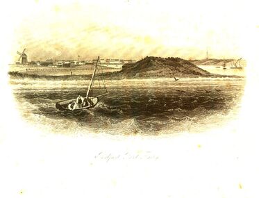 Port Fairy Historical Society Museum and Archives
Work on paper - Digital copy, Belfast Port Fairy
... Engraved and relief print of Drawing of Port Fairy Bay with small boat near Griffith island...Port Fairy Historical Society Museum and Archives 30 Gipps Street Port Fairy great-ocean-road Artist: Samuel Thomas Gill Born 21 May 1818 Perriton, Minehead, Somerset Died 27 October 1880 Melbourne Father: Samuel Gill Mother: Winifred Gill nee Oke engraving australian art Engraved and relief print of Drawing of Port Fairy Bay with small boat near Griffith island Belfast Port Fairy Work on paper Digital copy ...Artist: Samuel Thomas Gill Born 21 May 1818 Perriton, Minehead, Somerset Died 27 October 1880 Melbourne Father: Samuel Gill Mother: Winifred Gill nee Oke Engraved and relief print of Drawing of Port Fairy Bay with small boat near Griffith islandengraving, australian art -
 Port Fairy Historical Society Museum and Archives
Photograph
... Black and white photograph of East Beach near Battery Hill looking toward Griffith Island lighthouse in background...Port Fairy Historical Society Museum and Archives 30 Gipps Street Port Fairy great-ocean-road East Beach south east corner East beach battery hill training walls lighthouse lighthouse keepers cottages flagstaff Black and white photograph of East Beach near Battery Hill looking toward Griffith Island lighthouse in background Photograph Photograph ...East Beach south east cornerBlack and white photograph of East Beach near Battery Hill looking toward Griffith Island lighthouse in backgroundeast beach, battery hill, training walls, lighthouse, lighthouse keepers cottages, flagstaff -
 Port Fairy Historical Society Museum and Archives
Photograph, C. 1925
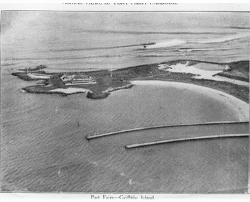
... Black and white aerial photograph of Griffith island showing the lighthouse keeper’s compound, the large flagstaff and the river training walls in the foreground...Golding Handwritten on the back of the copy "Port Fairyb Harbour 1925" Black and white aerial photograph of Griffith island showing the lighthouse keeper’s compound, the large flagstaff and the river training walls in the foreground Photograph Photograph ...Black and white arial photograph of the Moyne river entrance, the original signed by R.W.Golding.Black and white aerial photograph of Griffith island showing the lighthouse keeper’s compound, the large flagstaff and the river training walls in the foregroundHand written on the back "Port Fairy Moyne River Entrance R. W. Golding Handwritten on the back of the copy "Port Fairyb Harbour 1925"local history, photography, photographs, slides, film, arial, moyne river -
 Federation University Historical Collection
Report, Port Fairy: Environmental/Physical Plan, 1999, 11/06/1999
... ...griffith island...Barker Library (top floor) Mount Helen goldfields victorian tourisim industry tourism port fairy alumni port fairy folk festival griffith island portland pea soup mott's cottage mill's cottage port fairy lighthouse moyne river Report compiled by fivestudents of Tourism at University of Ballarat (later Federation University Australia) Port Fairy: Environmental/Physical Plan, 1999 Report Damien King Morag Marjoribanks Belinda Pearce Rebecca Plant Marc Wright ...Report compiled by fivestudents of Tourism at University of Ballarat (later Federation University Australia)victorian tourisim industry, tourism, port fairy, alumni, port fairy folk festival, griffith island, portland, pea soup, mott's cottage, mill's cottage, port fairy lighthouse, moyne river -
Port Fairy Historical Society Museum and Archives
Photograph
... ...griffith island...Port Fairy Historical Society Museum and Archives 30 Gipps Street Port Fairy great-ocean-road Aerial view across the Moyne river aerial moyne river martin's point port fairy barge dredge pudney ground griffith island Black and white photograph of Martins Point, river moyne and the pudney grounds from the air Photograph Photograph ...Aerial view across the Moyne river Black and white photograph of Martins Point, river moyne and the pudney grounds from the air aerial, moyne, river, martin's point, port fairy, barge, dredge, pudney ground, griffith island -
 Port Fairy Historical Society Museum and Archives
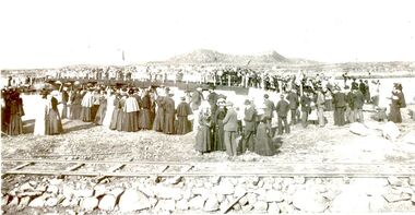
Photograph, Opening of bridge over South West Passage 1887, 1887
... ...Griffith island...This would also allow the public access to the island for fishing. events civil ceremony Griffith island rail bridge Black and White Photograph of Opening of bridge over South West Passage 1887 Opening of bridge over South West Passage 1887 Photograph Photograph ...The opening of the bridge over the South West Passage would now allow the lighthouse keeper to walk between the island and the mainland carrying his produce and herding his cattle rather than loading a boat to transport everything. This would also allow the public access to the island for fishing. Black and White Photograph of Opening of bridge over South West Passage 1887events, civil, ceremony, griffith island, rail, bridge -
Port Fairy Historical Society Museum and Archives
Photograph - Painting, Barque Sydney Griffiths
... ...griffith island...Port Fairy Historical Society Museum and Archives 30 Gipps Street Port Fairy great-ocean-road This photograph was taken after the painting had been repaired and restored by conservators of Melbourne Museum ship boat sea river sydney griffiths barque griffith island coloured photograph of a painting of Barque Sydney Griffiths Barque Sydney Griffiths Photograph Painting ...This photograph was taken after the painting had been repaired and restored by conservators of Melbourne Museumcoloured photograph of a painting of Barque Sydney Griffithsship, boat, sea, river, sydney griffiths, barque, griffith island -
 Port Fairy Historical Society Museum and Archives
Painting - painting, Watercolour, Elsbee?, The Barque Sydney Griffiths, c.1850
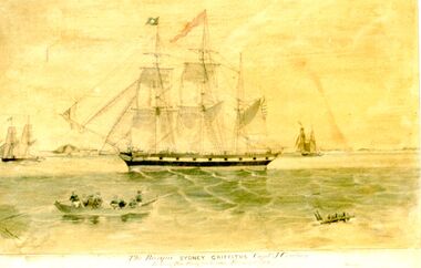
... A watercolour painting on paper and linen in a gold and Black frame showing the Barque "Sydney Griffiths" sailing before Griffith island, also shown "Essington" and "The Brothers" John Griffiths House and other buildings on shore..."Essington" "Brothers" A watercolour painting on paper and linen in a gold and Black frame showing the Barque "Sydney Griffiths" sailing before Griffith island, also shown "Essington" and "The Brothers" John Griffiths House and other buildings on shore The Barque Sydney Griffiths Painting painting, Watercolour Elsbee? ...This painting of the barque Sydney Griffiths and two smaller ships, ‘the brothers’ and Essington’ graced the offices of Powling solicitors for 3 generations. This painting illustrates the scene of the first export of wool from Belfast to England.Depicts a significant moment in time when the first shipment of wool from the port was being loaded for London.A watercolour painting on paper and linen in a gold and Black frame showing the Barque "Sydney Griffiths" sailing before Griffith island, also shown "Essington" and "The Brothers" John Griffiths House and other buildings on shoreThe Barque "Sydney Griffiths" Capt. Cowtan leaving Port Fairy for London, February 8th 1851. "Essington" "Brothers"local history, illustrations, powlings, watercolours, exports, essington, sydney griffiths, shipping, the brothers, wool export, capt cowtan -
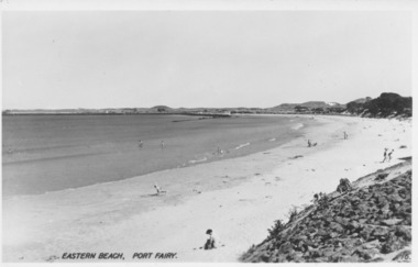 Port Fairy Historical Society Museum and Archives
Photograph, Valentine Publishing Co, Eastern Beach Port Fairy
... Early view looking towards Griffiths Island showing the dunes with vegetation on them...Port Fairy Historical Society Museum and Archives 30 Gipps Street Port Fairy great-ocean-road Early view looking towards Griffiths Island showing the dunes with vegetation on them Reflects change in coast over time beach sea seascape east beach Eastern Beach Port Fairy 16 Black and white photograph of curve of East Beach Eastern Beach Port Fairy Photograph Photograph Valentine Publishing Co. ...Early view looking towards Griffiths Island showing the dunes with vegetation on themReflects change in coast over timeBlack and white photograph of curve of East BeachEastern Beach Port Fairy 16beach, sea, seascape, east beach -
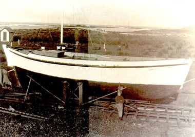 Port Fairy Historical Society Museum and Archives
Photograph
... The fishing boat "Amaryllis" was built by the Haldane Brothers in 1935 on Griffith Island for their own use while they were lighthouse keepers. ...Port Fairy Historical Society Museum and Archives 30 Gipps Street Port Fairy great-ocean-road The fishing boat "Amaryllis" was built by the Haldane Brothers in 1935 on Griffith Island for their own use while they were lighthouse keepers. ...The fishing boat "Amaryllis" was built by the Haldane Brothers in 1935 on Griffith Island for their own use while they were lighthouse keepers. The boat was a well boat RFB 1260 on the Port Fairy register 1936 - 1943 in the name of W.H.Haldane She was owned and operated by the brothers until she was requisitioned by the armed services during 1943. She did not return to Port Fairy.Black and white photographfish haldane brothers, rfb 1260, fishing, boat, industry, amaryllis -
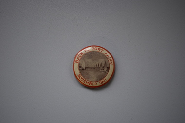 Warrnambool and District Historical Society Inc.
Badge, Back to Port Fairy, 1921
... By 1921 Europeans had settled in Port Fairy for about 85 years, with John Griffiths setting up a whaling station on Griffiths Island in 1836 and James Atkinson establishing the town area in the early 1840s. ...By 1921 Europeans had settled in Port Fairy for about 85 years, with John Griffiths setting up a whaling station on Griffiths Island in 1836 and James Atkinson establishing the town area in the early 1840s. ...This badge was produced to celebrate a gathering of past and present residents at Port Fairy in 1921, with the event officially called ‘Back to Port Fairy’. Port Fairy is on the Princes Highway, 28 kilometres west of Warrnambool. By 1921 Europeans had settled in Port Fairy for about 85 years, with John Griffiths setting up a whaling station on Griffiths Island in 1836 and James Atkinson establishing the town area in the early 1840s. Atkinson called the town Belfast and it was known by this name until 1887 when the name reverted to Port Fairy. The Back to Port Fairy celebrations in 1921 ran from November 10th to November 19th. A month before, in October 1921, the Glaxo factory, a prominent business in Port Fairy for many years, had been established.This badge is of minor interest as a memento of a celebration at Port Fairy in 1921 and is retained for display purposes.This is a metal badge with red edging, red lettering and a grey-coloured image of boats at the Port Fairy wharf. Back to Port Fairy November 1921port fairy, history of warrnambool, badge, port fairy -
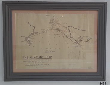 Flagstaff Hill Maritime Museum and Village
Document - Location Chart, The Mahogany Ship, 2007
... The chart shows the coordinates for the Summits of Griffith Island and of Middle Island. It also has the depths of the sea at various intervals and shows the shore and sand dunes, lighthouses and other reference points. ...The chart shows the coordinates for the Summits of Griffith Island and of Middle Island. It also has the depths of the sea at various intervals and shows the shore and sand dunes, lighthouses and other reference points. ...This chart shows a possible site for the fabled wreck called the 'Mahogany Ship'. Flagstaff Hill’s collection includes other objects that some say could be relics from this Ancient Wreck, (also called the Gold Ship, or the Ancient Vessel). The chart shows the coordinates for the Summits of Griffith Island and of Middle Island. It also has the depths of the sea at various intervals and shows the shore and sand dunes, lighthouses and other reference points. The mystery of the Mahogany Ship began in 1836 when two shipwrecked sealers discovered the remains of an “ancient vessel” in the sand dunes about four miles west of Warrnambool. Since the last recorded sightings in the 1880’s the true origin of the Mahogany Ship has remained one of Australia’s most famous historical mysteries or fables. One of the more recent theories is that the vessel was one of the Portuguese ships exploring the Australian coast in 1522. For over one hundred years searchers have attempted to locate and identify the wreck. The search continues for the tangible evidence which will once and for all establish the Mahogany Ship’s place in Australia’s History.The chart represents the worldwide interest in locating the wreck of the Mahogany Ship. Locating the actual wreck or proving the existence of a Portuguese ship's wreck could change the history of the discovery of Australia. A Mahogany Ship committee was formed to gather and research information about the discovery of the wrecked ship. A large amount of money was offered as a prize for finding the wreck or parts of it. People have written books, painted images, made videos and told tales of the ship but it continues to remain a mystery or even a fable. The chart is significant for its possible link to one of Victoria’s and Australia’s maritime mysteries, the Mahogany Ship (also known as the Ancient Wreck). It is one of very few known relics that could give evidence of the existence and history of the vessel. It is listed on the Victorian Heritage Register S438 as it is one of Victoria’s oldest recorded shipwrecks. The identity of the vessel has the potential to change Australia’s history.A chart in a wooden frame, behind glass. The chart shows the approximate position of the mystery Ancient Wreck, later called the "Mahogany Ship". The chart is a copy and is based on the Admiralty Chart by Lieut. Stanley, dated 1872. Lower left: "THE MAHOGANY SHIP" "LOCALITY PLAN, ENLARGED FROM LIEUT. STANLEY'S ADMIRALTY CHART 1872" "APPROXIMATE POSITION OF WRECK MARKED [symbol of a Portuguese cross]" Other labels on chart: "BELFAST" "PORT FIARY" "GRIFFITHS I" "RIVER MOYNE" "RIVER MERRI" "ARMSTRONG BAY" " GORMANS LANE" "TOWER HILL" "KOROIT" "HELEN ROCK" "WARRNAMBOOL" "LADY BAY" "MIDDLE I" "LIGHT HO." Lower right: "G 410 B" Label on the back; "This chart presented to the Mahogany Ship Committee and Flagstaff Hill by Avis Quarrell, April 2007"warrnambool, shipwrecked coast, flagstaff hill maritime museum, shipwreck coast, mahogany ship, ancient vessel, ancient wreck, portuguese ship, coastal reserve, fabled wreck, gold ship, griffiths island, belfast (now port fairy), koroit, location plan, leuit. stanley, admiralty chart 1872, tower hill, merri river, moyne river, middle island, helen rock, armstrong bay, griffiths land -
Port Fairy Historical Society Museum and Archives
Photograph, Mason, John
... he built the Court house in 1859 and completed the breakwater between Rabbit Island and Griffith Island started by James Atkinson and John Griffith in 1849, also the first bridge over the Moyne river which connected with Battery Lane and the Bay. ...He built the Rosebrook Bridge in 1855 and the first official Post Office ( a timber structure in Bank Street) in 1857, replacing it with a stone office in 1865. he built the Court house in 1859 and completed the breakwater between Rabbit Island and Griffith Island started by James Atkinson and John Griffith in 1849, also the first bridge over the Moyne river which connected with Battery Lane and the Bay. ...Captain John Mason came from Stirling in Scotland, arriving at Port Fairy in 1844. One year after James Atkinson obtained his Special Survey of the area. Thus his life covers all the history of Port Fairy when it was known as Belfast. He married Jane Murray in Portland in 1846 and they had 5 children, Jane died in 1855 and ten years later he married Ann Brown widow of Abijah Brown. They had no children and she died in 1887. In due course he became known as Captain Mason, he was not a sea captain, but captain of the Belfast Volunteers, a Rifle Corps formed in 1859 as a consequence of the Crimean War, and later reconstituted as the Belfast Volunteer Corps. For 40 years he displayed a remarkable versatility in his various occupations. Starting as an Innkeeper - he took over the Stag Inn from Captain Saunders in 1852, for 3 years. He then became a carpenter, stonemason, architect, estate agent honorary technical advisor to the Borough and treasurer to the Shire, and Savings Bank Secretary. They thought so well of John mason in Belfast that they elected him to the first Roads Board in 1853 and to the first Municipal Council in 1856. He was Chairman four times and with Councillors David Talbot and Joseph Whitehead designed the Council's Common Seal and the Motto "Commune Bonum".He was the first Mayor of the Borough in 1863 for a period of 7 weeks. He was responsible for the design, supervision or construction of many of the buildings in the town; most still standing today. He built the Rosebrook Bridge in 1855 and the first official Post Office ( a timber structure in Bank Street) in 1857, replacing it with a stone office in 1865. he built the Court house in 1859 and completed the breakwater between Rabbit Island and Griffith Island started by James Atkinson and John Griffith in 1849, also the first bridge over the Moyne river which connected with Battery Lane and the Bay. Among the many buildings associated with John Mason are Gobles Mill, Tynemouth Villa, 10-12 Princes Street, the Mechanics Institute, the Commercial Hotel, Yambuk and Mickey Bourke's Pub in Koroit. However, he did not build "Riverdale" in Gipps Street as is thought. He had a store and workshop on this site but sold the property in 1872 before the house was built. After an almost uninterrupted term as Councillor starting with the Municipality in 1856, John resigned from the Council in 1873. He well deserved the illuminated address they gave to him and the toast that they drank in the Bank Hotel champagne. Within the year he was working for the Borough as its engineer., surveyor, general supervisor and advisor of public works, simply as the man to whom all difficult problems were referred and at very little expense. John Mason was a great worker for his town and devoted himself unsparingly to the community. That his work was appreciated was shown by the way in which people rallied to his aid when, in the end, he found himself in financial difficulties and his reputation was challenge; arrested for embezzling from the Savings Bank of which he was the actuary in 1882. The money was repaid and the charges found not proven at his trial. He was an early member of the Loyal Prince Albert Lodge, and a founding member of the smaller Loyal Belfast Lodge in 1863. He was also a member of the Horticultural Society. Captain John Mason Died on the 14th of October 1891 (see also 62-04-046 photo)Sepia photograph on heavy cardStevenson & McNicoll photo. 108 Elizabeth Street Melbourne copies can be obtained at anytimedefence, captain, mason, carpenter, councillor, mayor -
 Phillip Island and District Historical Society Inc.
Photograph, Early 1900's
... Phillip Island and District Historical Society Inc. phillip-island-and-the-bass-coast Donated by Jessie Smith (nee Small) horses grazing phillip island san remo jessie smith Fiddlers Green Photograph of two horses grazing on hillside at Fiddlers Green, Griffiths Point (now San Remo) foreshore of Westernport. ...Donated by Jessie Smith (nee Small)Photograph of two horses grazing on hillside at Fiddlers Green, Griffiths Point (now San Remo) foreshore of Westernport. White fences dividing paddocks. School house on left behind trees and shed on right of photo. Houses and sea in background.horses grazing, phillip island, san remo, jessie smith, fiddlers green -
 Phillip Island and District Historical Society Inc.
Photograph, Early 1900's
... Phillip Island and District Historical Society Inc. phillip-island-and-the-bass-coast Donated by Jessie Smith (nee Small) horse tethered phillip island jessie smith Griffiths Point San Remo Pier Hotel San Remo Bergin's Pier San Remo Sepia photograph of a horse tethered to fence at Griffiths Point (now San Remo). ...Donated by Jessie Smith (nee Small)Sepia photograph of a horse tethered to fence at Griffiths Point (now San Remo). Pier Hotel in the background on left. Right foreground Bergin's Pier. Mid pier, Government pier. Background part at the Coal pier.horse tethered, phillip island, jessie smith, griffiths point, san remo, pier hotel san remo, bergin's pier san remo -
 Phillip Island and District Historical Society Inc.
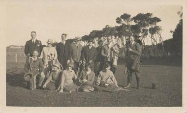
Photograph, Early 1920's
... Phillip Island and District Historical Society Inc. phillip-island-and-the-bass-coast One of 5 photographs donated by Lyn Chambers & Frank Dominick - Wonthaggi Historical Society The following information was sent by a reader of VC for which we are very thankful. The golf course in San Remo was opened in 1922 and was on the land adjacent to Ocean Grove where Griffiths ...One of 5 photographs donated by Lyn Chambers & Frank Dominick - Wonthaggi Historical Society The following information was sent by a reader of VC for which we are very thankful. The golf course in San Remo was opened in 1922 and was on the land adjacent to Ocean Grove where Griffiths point lodge and Davis Point road now stand. One hole was placed on the flat land on the beach. There were red flags and the cows used to eat them. Black & White photograph of a group of people with their golf clubs. Noted on back of photo "San Remo Golf Links". A question mark re location as it seems too flat. Maybe it was in Cowes?? This has now been updated - see below under "Historical Information" 4/9/2016On back: San Remo Golf Links early 1920'sgolf links san remo, lyn chambers -
 Phillip Island and District Historical Society Inc.
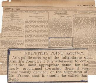
Newspaper clippings, The Age Newspaper, 1888
... Phillip Island and District Historical Society Inc. phillip-island-and-the-bass-coast News item showing report of Public meeting to name township growing at Griffiths Point. ...News item showing report of Public meeting to name township growing at Griffiths Point. Suggested by Mr Fraser that it be named San Remo. 1888Newspaper cutting with highlighted item "Griffiths Point Saturday" taken from The Age.July 9, 1888. No. 421local history, documents, newspapers, griffiths point, san remo, local area development, black & white newspaper clipping, newspapers san remo -
Phillip Island and District Historical Society Inc.
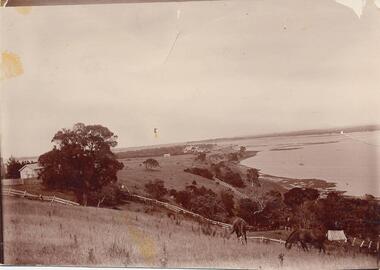
Photograph, c 1900
... Phillip Island and District Historical Society Inc. phillip-island-and-the-bass-coast Coal tramway from Kilcunda to Griffiths Point - horses grazing in foreground. ...Coal tramway from Kilcunda to Griffiths Point - horses grazing in foreground. House and tree on left of photograph. White railway track winding through the fields which are overlooking the water.Kilcunda to Griffiths Point Coal Tramway - rural scene overlooking water.local history, photography, photographs, slides, film, tramway, kilcunda to griffiths point, black & white photograph, miss elms san remo -
Phillip Island and District Historical Society Inc.
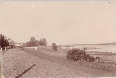
Photograph, c 1900
... Local History PHOTOGRAPHY Photographs Slides Film Coal Tramway Piers San Remo Black & White Photograph Miss Elms San Remo Phillip Island from San Remo Harbour Griffiths Point Coal pier terminus of the Coal Tramway. ...Track leading down to two piers. Boat shed, horse and cart adjacent to pier in foreground. Ferry and fishing boat moored at end of pier. Large tree on left of picture. Phillip Island coastline on far side of water.Griffiths Point Coal pier terminus of the Coal Tramway.Phillip Island from San Remo Harbourlocal history, photography, photographs, slides, film, coal tramway, piers, san remo, black & white photograph, miss elms san remo