Showing 118 items matching "ground operation"
-
 Moorabbin Air Museum
Book - Details of air crew and ground crew operation and maintenance of Lancaster bomber aircraft, The Lancaster Manual The Official Air Publication for the Lancaster Mk I and III, 1942-1945, The Lancaster Manual The Official Air Publication for the Lancaster Mk I and III, 1942-1945, 1977
... Details of air crew and ground crew operation and maintenance of Lancaster bomber aircraft, The Lancaster Manual The Official Air Publication for the Lancaster Mk I and III, 1942-1945...Details of air crew and ground crew operation and maintenance of Lancaster bomber aircraft, The Lancaster Manual The Official Air Publication for the Lancaster Mk I and III, 1942-1945...Moorabbin Air Museum Moorabbin Airport 12 First Street Moorabbin melbourne Details of air crew and ground crew operation and maintenance of Lancaster bomber aircraft, The Lancaster Manual The Official Air Publication for the Lancaster Mk I and III, 1942-1945 Details of air crew and ground crew operation and maintenance of Lancaster bomber aircraft, The Lancaster Manual The Official Air Publication for the Lancaster Mk I and III, 1942-1945 Jacket cover showing photo of in flight Lancaster with blue background The Lancaster Manual The Official Air Publication for the Lancaster Mk I and III, 1942-1945 Book Details of air crew and ground crew operation and maintenance of Lancaster bomber aircraft, The Lancaster Manual The Official Air Publication for the Lancaster Mk I and III, 1942-1945 Royal Airforce ...Details of air crew and ground crew operation and maintenance of Lancaster bomber aircraft, The Lancaster Manual The Official Air Publication for the Lancaster Mk I and III, 1942-1945Jacket cover showing photo of in flight Lancaster with blue backgroundnon-fictionDetails of air crew and ground crew operation and maintenance of Lancaster bomber aircraft, The Lancaster Manual The Official Air Publication for the Lancaster Mk I and III, 1942-1945 -
Moorabbin Air Museum
Book - Rolls Royce Jet Engines, The Jet Engine
... ...Ground operation...Moorabbin Air Museum Moorabbin Airport 12 First Street Moorabbin melbourne Rolls Royce jet engines Basic mechanics Working cycle & airflow Compressors Combustion chambers Turbines Exhaust system Noise suppression Thrust reversal Afterburning Fuel systems Water injection Lubrication Air cooling & sealing Starting and ignition Ice protection Fire protection Controls & instrumentation Powerplant installation Manufacture & overhaul Ground operation V/STOL Thrust redistribution Performance Description of working & underlying principles of aero gas turbine engines, circa 1966 The Jet Engine Book Rolls Royce Jet Engines ...Description of working & underlying principles of aero gas turbine engines, circa 1966non-fictionDescription of working & underlying principles of aero gas turbine engines, circa 1966basic mechanics, working cycle & airflow, compressors, combustion chambers, turbines, exhaust system, noise suppression, thrust reversal, afterburning, fuel systems, water injection, lubrication, air cooling & sealing, starting and ignition, ice protection, fire protection, controls & instrumentation, powerplant installation, manufacture & overhaul, ground operation, v/stol, thrust redistribution, performance -
 Eltham District Historical Society Inc
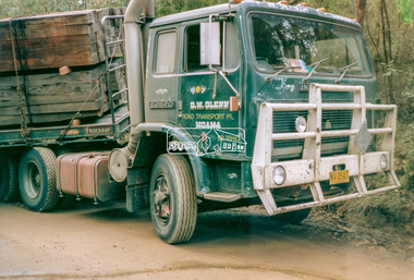
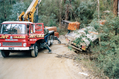
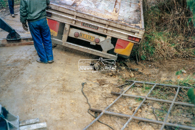
Photograph - Colour Print, Salvage operation in the Henley Road area Kangaroo Ground, c.1990
... Salvage operation in the Henley Road area Kangaroo Ground...Ground...Salvage Operation...Glenn Road Transport Pty Ltd Henley Road Jet Cranes Kangaroo Ground Salvage Operation Trucks LLC543 (Vic. Regn.) NV05AI (Fedl HV Regn.) ...A truck operated by G.W. Glenn Road Transport Pty Ltd of Moama, NSW was transporting a load of sleepers and wood posts along Henley Road, Kangaroo Ground. As a result of signioficantly wet conditions, the truck became disabled when the trailer slipped off the verge of the unsealed muddy road whilst negotiating a hairpin bend. The load was removed from the trailer by Jet Cranes in order to facilitate pulling the trailer back on to the road.g.w. glenn road transport pty ltd, henley road, jet cranes, kangaroo ground, salvage operation, trucks, llc543 (vic. regn.), nv05ai (fedl hv regn.) -
 Eltham District Historical Society Inc
Photograph - Colour Print, Salvage operation in the Henley Road area Kangaroo Ground, c.1990
... Salvage operation in the Henley Road area Kangaroo Ground...Ground...Salvage Operation...Glenn Road Transport Pty Ltd Henley Road Jet Cranes Kangaroo Ground Salvage Operation Trucks LLC543 (Vic. Regn.) NV05AI (Fedl HV Regn.) ...A truck operated by G.W. Glenn Road Transport Pty Ltd of Moama, NSW was transporting a load of sleepers and wood posts along Henley Road, Kangaroo Ground. As a result of signioficantly wet conditions, the truck became disabled when the trailer slipped off the verge of the unsealed muddy road whilst negotiating a hairpin bend. The load was removed from the trailer by Jet Cranes in order to facilitate pulling the trailer back on to the road.g.w. glenn road transport pty ltd, henley road, jet cranes, kangaroo ground, salvage operation, trucks, llc543 (vic. regn.), nv05ai (fedl hv regn.) -
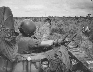
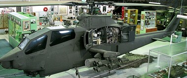 National Vietnam Veterans Museum (NVVM)
Vehicle - Helicopter, Bell AH-IG Cobra Bell AH-1, 1967 approx
... Army in Vietnam to support Australian & U.S. army ground operations. In addition to the M197 three barrelled 20mm Gatling gun, it carried eight anti-armour missiles and forty eight 2.75mm unguided air to ground rockets. ...Army in Vietnam to support Australian & U.S. army ground operations. In addition to the M197 three barrelled 20mm Gatling gun, it carried eight anti-armour missiles and forty eight 2.75mm unguided air to ground rockets. ...After 2 years of negotiation between VVAA Representatives and the US Army, the Huey Cobra has landed in Melbourne. The exercise needed the support of our local Member, Mr. Greg Hunt, to ‘clear the way ‘ through the Customs and GST minefield. The helicopter, valued at $7.9 million is complete with full armaments and was brought to Museum standard while ensuring that no weaponry could ever be reactivated. The Museum paid for the helicopter to be ‘brought to museum standard’. This meant in part that the weaponry was rendered innocuous and various structural members were weakened to ensure that the craft would never fly again. Fortunately the alterations are not apparent to the display, and while there are two other Cobras in Australia, this is the only one with full armament. A heavily armed ground attack helicopter with single Lycoming T53-L-13 turbine engineused by the U.S. Army in Vietnam to support Australian & U.S. army ground operations. In addition to the M197 three barrelled 20mm Gatling gun, it carried eight anti-armour missiles and forty eight 2.75mm unguided air to ground rockets. This particular aircraft served in Vietnam from 1968 until 1971 and was damaged twice in combat. The aircraft is currently finished in a low visibility all-over mid green which includes the full US Army insignia and carries the Serial No. 69-15092helicopters, bell, weaponry, cobra, us military equipment, gunship -
 National Vietnam Veterans Museum (NVVM)
Map
... A large laminated coloured map of Joint Operations Graphic (ground), Vietnam. there are specific information highlighted in pen....National Vietnam Veterans Museum (NVVM) 25 Veterans Drive Newhaven phillip-island-and-the-bass-coast 3RAR McPhail Collection Map A large laminated coloured map of Joint Operations Graphic (ground), Vietnam. there are specific information highlighted in pen. ...A large laminated coloured map of Joint Operations Graphic (ground), Vietnam. there are specific information highlighted in pen.3rar, mcphail collection, map -
 Bendigo Military Museum
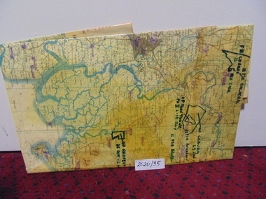
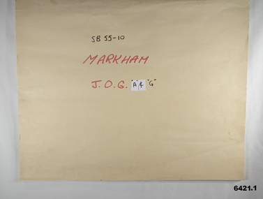
Map - SB55-10 Markham Joint Operations Graphics Air and Ground print separations, Royal Australian Survey Corps, Bendigo, Dec 1981
... This map series was produced in two versions to help coordinate military Ground Operations and Air Operations. The ground users required that heights and measurements were in Metres, whilst air users required height information in Feet for altimeters. ...This map series was produced in two versions to help coordinate military Ground Operations and Air Operations. The ground users required that heights and measurements were in Metres, whilst air users required height information in Feet for altimeters. ...This set of map prints was assembled as a training aid. The collection is a complete set of individual color prints of each colour used on the final printed maps for each map Joint Operations Graphic (JOG) JOG Ground and JOG Air versions. This map series was produced in two versions to help coordinate military Ground Operations and Air Operations. The ground users required that heights and measurements were in Metres, whilst air users required height information in Feet for altimeters. The Air Version also contained more Aeronautical information including safe flying height information called Maximum Elevation Figures (MEF). Later printing of JOG incorporated printing in just four colours Cyan, Magenta, Yellow and Black (CMYK). Item 6421.1 is an example of a JOG Ground and item 6421.2 is an example of its matching JOG Air version.1:250,000 SB55-10 Markham JOG A and G colour separations bound together in a manilla card covered folder bound with a timber edge. royal australian survey corps, rasvy, fortuna, army survey regiment, army svy regt, asr -
 Eltham District Historical Society Inc
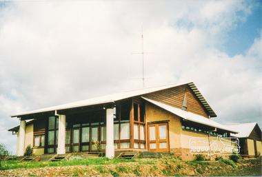
Photograph, Emergency Operations Centre, S.E.S., Kangaroo Ground
... In 2017 known as the Kangaroo Ground Operations Centre a facility for hire managed by the Shire of Nillumbik. ...Two colour photographs of mud brick Emergency Operations Centre building, Kangaroo Ground...Eltham District Historical Society Inc 728 Main Rd Eltham melbourne In 2017 known as the Kangaroo Ground Operations Centre a facility for hire managed by the Shire of Nillumbik. ...In 2017 known as the Kangaroo Ground Operations Centre a facility for hire managed by the Shire of Nillumbik. On 7 February 2009 (Black Saturday) the CFA Incident Control Centre (ICC) was located here. Described in "Worst of Days: Inside the black Saturday firestorm" by Karen Kissane (access via Google books): "..the ICC is part of a mud brick complex built in the 1980s as an emergency operations centre for several agencies, including the State Emergency Service. It is also home to the headquarters of the CFA's Lower Yarra Group. A small office with a whiteboard would be the incident controller's office throughout the office, but a larger central room, with data projectors, "smart boards" and maps would house the rest of the team.."Statement of Significance From the Victorian Heritage Database (2010) What is significant? The 1988 emergency operations centre and the surrounding site to the title boundaries. How is it significant? The emergency operations centre is architecturally, aesthetically, socially and historically significant to the Shire of Nillumbik. Why is it significant? The emergency operations centre is architecturally and historically significant as a good and rare example of a large public building constructed in a 1980s version of the 'Eltham style', and as a rare attempt to adapt the 'Eltham-style' aesthetic to meet the changing demands of the Shire in the 1980s (Criteria B, D & E). The emergency operations centre is architecturally and aesthetically significant because it is constructed of mud brick and features: a central entry with a tile mural (Criterion E). The emergency operations centre is socially significant because it is a focal point for the community and has played an important role in protecting the community since 1988 (Criterion G).Two colour photographs of mud brick Emergency Operations Centre building, Kangaroo Groundbuildings, mud brick, emergency centre, kangaroo ground -
 Bendigo Military Museum
Album - PHOTOGRAPHIC ALBUM WW2, Album of reproduced photographs featuring No 3 Squadron RAAF in Africa, Sicily, Malta and Italy
... Featuring ground crew operations of 3 Squadron RAAF in Africa, Malta, Sicily and Italy. ...Featuring ground crew operations of 3 Squadron RAAF in Africa, Malta, Sicily and Italy. ...Part of Thomason collection of militaria and memorabilia. Album dating from 1950's contains reproductions of photographs known to exist elsewhere. Featuring ground crew operations of 3 Squadron RAAF in Africa, Malta, Sicily and Italy. Part of the collection of William (Bill) Thomason, refer catalogue number 3136P for more items. . Photo album dating from 1950's featuring official distributed photographs featuring No 3 Squadron RAAFpostcards, ww1, ww2 -
 National Vietnam Veterans Museum (NVVM)
Photograph, Gibbons, Denis, Rowe On Patrol
... A black and white photograph of Cpl Normie Rowe looks cautiously at a number of Vietnamse discovered far from the nearest village as his troops move through reasonably open ground whilst on operations. The vietnamese, all women and children were collecting local herbs and grasses....The images held within the National Vietnam Veterans Museum make up the Gibbons Collection Photograph Cpl Normie Rowe Gibbons Collection Catalogue Vietnamese Women Vietnamese Children APC Australian Troops Denis Gibbons A black and white photograph of Cpl Normie Rowe looks cautiously at a number of Vietnamse discovered far from the nearest village as his troops move through reasonably open ground whilst on operations. The vietnamese, all women and children were collecting local herbs and grasses. ...Denis Gibbons (1937 – 2011) Trained with the Australian Army, before travelling to Vietnam in January 1966, Denis stayed with the 1st Australian Task Force in Nui Dat working as a photographer. For almost five years Gibbons toured with nine Australian infantry battalions, posting compelling war images from within many combat zones before being flown out in late November 1970 after sustaining injuries. The images held within the National Vietnam Veterans Museum make up the Gibbons Collection A black and white photograph of Cpl Normie Rowe looks cautiously at a number of Vietnamse discovered far from the nearest village as his troops move through reasonably open ground whilst on operations. The vietnamese, all women and children were collecting local herbs and grasses.photograph, cpl normie rowe, gibbons collection catalogue, vietnamese women, vietnamese children, apc, australian troops, denis gibbons -
 Bendigo Military Museum
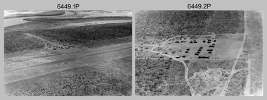
Photograph - RA Svy Project C4 Aerodist Operation, Eastern Arnhem Land, NT, 1967
... operations for 12 years from 1964 to 1975. Aerodist MRC2 was a tellurometer-based system adapted for aircraft to accurately measure distances between non-intervisible ground survey stations, using the aircraft as an intermediate station. ...Unidentified survey operations base, L to R: unidentified technician. .11) - Unidentified technician reading two survey altimeters to compute corrections to the measured distances for atmospheric refraction and to compute the sea level distances from the slope distances aircraft to the ground stations. .12) - Photo, black & white, 1967. ...Unidentified survey operations base, L to R: unidentified technician. .11) - Unidentified technician reading two survey altimeters to compute corrections to the measured distances for atmospheric refraction and to compute the sea level distances from the slope distances aircraft to the ground stations. .12) - Photo, black & white, 1967. ...This is a set of 30 photographs of Royal Australian Survey Corps (RA Svy) personnel from Central Comd Fd Svy Unit (Adelaide) on Aerodist survey operation - Project C4 in Eastern Arnhem Land, Northern Territory in 1967. Photos of personnel were taken either at the operations base at Numbulwar or the main base at Gove (Nhulunbuy). RA Svy conducted nineteen Aerodist operations for 12 years from 1964 to 1975. Aerodist MRC2 was a tellurometer-based system adapted for aircraft to accurately measure distances between non-intervisible ground survey stations, using the aircraft as an intermediate station. Lower order geodetic results could be achieved by survey network trilateration. The measured distances between stations formed survey networks from which each station’s latitude and longitude was computed. Aerodist MRC2 was RA Svy’s major horizontal control survey tool for mainly medium scale topographic mapping (scale 1:100,000 Class A being spatially accurate to within 50 metres) in PNG, northern NT, north-west WA, Kalimantan Barat (West) Indonesia, Sumatra Indonesia, Gulf of Carpentaria and Cape York, QLD. In 1967, the Aerodist MRC2 Master equipment was installed in the aircraft featured in this set of photos, Executive Air Services’ (Essendon VIC) Grand Aero Commander VH-EXX. It was the same aircraft type and company contracted to Division of National Mapping for Aerodist MRC2 surveys. From July to October 1967 the aircraft was attached to Central Comd Fd Svy Unit (Adelaide - Major Don Ridge) on Project C4 eastern-Arnhem Land NT, where 317 Aerodist lines measuring 17,300 line miles were successfully completed. This was the most productive Aerodist project thus far. The most common helicopter used by RA Svy up to 1972 was the civilian Bell 47G-2 and the Sioux Light Observation Helicopters (LOH), the Australian Army’s equivalent featured in this photo set. These light observation helicopters had a limiting load carrying capacity of up to about 500 pounds. By comparison, one Aerodist team including two people weighed up to 1,500 pounds. Source: Royal Australian Survey Corps – Aerodist Years 1964-1975 by Peter Jensen. Refer to Item 9061.26P for more photos taken during this Aerodist survey operation.This is a set of 30 photographs of Royal Australian Survey Corps (RA Svy) personnel on Aerodist survey operations in Eastern Arnhem Land, Northern Territory in 1967. The photographs are on 35mm negative film and scanned at 96 dpi. They are part of the Army Survey Regiment’s Collection. .1) to .4) - black & white, 20th August 1967, Project C4 Aerodist Operations Base - Numbulwar, NT. .5) - Photo, black & white, 1967. Probable wrecked Indonesian fishing vessel. .6) to .8) - Photo, black & white, 1967. Unidentified survey operations base, L to R: unidentified personnel. .9) - Photo, black & white, 1967. Unidentified survey operations base, unidentified soldier driving a Haflinger 4x4 Light utility vehicle. .10) - Photo, black & white, 1967. Unidentified survey operations base, L to R: unidentified technician. .11) - Unidentified technician reading two survey altimeters to compute corrections to the measured distances for atmospheric refraction and to compute the sea level distances from the slope distances aircraft to the ground stations. .12) - Photo, black & white, 1967. Survey operations base, L to R: unidentified (x3), W01 Pat Wood BEM, unidentified. .13) to .16) - Photo, black & white, 1967. Unidentified personnel operating remote Aerodist MRC2 ground instruments. .17) to .18) - Photo, black & white, 1967. Unknown RA Svy office location. .19) to .20) - Photo, black & white, 1967. Aerodist MRC2 Master equipment. .21) to .22) - Photo, black & white, 1967. Aero Commander VH-EXX probably at Gove, NT, Central Comd Fd Svy Unit (Adelaide) – OC Major Don Ridge. .23) to .25) - Photo, black & white, 1967. Aero Commander VH-EXX probably at Gove, NT. Unidentified personnel. .26) - Photo, black & white, 1967. Aero Commander VH-EXX probably at Gove, NT. Aerodist antenna pods are visible on the aircraft. .27) to .29) - Photo, black & white, 1967. Australian Army Sioux Light Observation Helicopter (LOH) probably at Gove, NT. .30) - Photo, black & white, 1967. Panelled U337 survey station, visible as a white cross on aerial identification photo..1P to .2P – date and location on edge of film negative. .5P to .28P – no annotations .29P - annotated in white ‘RW-JEP Gove NT’ .30P - annotated in white ‘U337 Spool No1 Jun67’royal australian survey corps, rasvy, army survey regiment, army svy regt, fortuna, asr, aerodist, surveying, central comd fd svy unit -
 Bendigo Military Museum
Administrative record - Army Survey Regiment - PNG JOG After Action Report Cartographic Sqn March 1982, DR Bowen, US Major, OC Carto Sqn, 22 Mar 1982
... The Royal Australian Survey Corps produced complete coverage of Papua New Guinea of Joint Operations Graphics (JOG) at 1:250,000 scale. JOG were produced in two versions JOG Ground in metres and JOG Air in feet. ...Bendigo Military Museum 37 - 39 Pall Mall Bendigo goldfields The Royal Australian Survey Corps produced complete coverage of Papua New Guinea of Joint Operations Graphics (JOG) at 1:250,000 scale. JOG were produced in two versions JOG Ground in metres and JOG Air in feet. ...The Royal Australian Survey Corps produced complete coverage of Papua New Guinea of Joint Operations Graphics (JOG) at 1:250,000 scale. JOG were produced in two versions JOG Ground in metres and JOG Air in feet. This report estimates the amount of manpower required to complete the last 30 x JOG and JOGA as at 22 March 1982 by Cartographic Squadron.A4 typed 4 x page report stapled top LHSroyal australian survey corps, rasvy, fortuna, army survey regiment, army svy regt, asr, png -
 Bendigo Military Museum
Photograph - RA Svy Project C4 Aerodist Operation, Eastern & Western Arnhem Land, NT, 1967, 1968
... operations for 12 years from 1964 to 1975. Aerodist MRC2 was a tellurometer-based system adapted for aircraft to accurately measure distances between non-intervisible ground survey stations, using the aircraft as an intermediate station. ...They are part of the Army Survey Regiment’s Collection. .1) to .2) – Photo, black & white, 1968, unidentified soldier with an opened can of food, possibly bully beef. .3) – Photo, black & white, 15 Aug 1968, aerial view of terrain taken from a helicopter in vicinity of MILINGIMBI SIERRA. .4) – Photo, black & white, 1967, aerial view of an island taken from a helicopter. .5) & .6) – Photo, black & white, 1967, unidentified soldier driving a Haflinger 4x4 Light utility vehicle with trailer. .7) – Photo, black & white, 1967, unidentified surveyors taking vertical measurements with a leveling instrument and staff. .8) – Photo, black & white, 1967, Australian Army Sioux Light Observation Helicopter (LOH) with float removed. .9) to .11) – Photo, black & white, 1967, Australian Army Sioux Light Observation Helicopter (LOH) with floats. .12) – Photo, black & white, 1967, civilian Bell 47G-2 helicopter (Australian Army Sioux LOH equivalent) refuelled. .13) – Photo, black & white, 1967, survey station on coastline surrounded by white plastic aerial photographic identification panels lined with rocks. .14) & .15) – Photo, black & white, 1967, soldier (possibly a signaller from RA Sigs) operating a radio. .16) – Photo, black & white, 1967, Central Comd Fd Svy Unit Operations Section tent, Main Base Gove (Nhulunbuy) L to R: SPR Harry Dunn, WO1 Pat Wood BEM. .17) – Photo, black & white, 1967, Central Comd Fd Svy Unit Operations Section tent, Main Base Gove (Nhulunbuy) L to R: unidentified, WO1 Pat Wood BEM. .18) – Photo, black & white, 1967, Central Comd Fd Svy Unit Operations Section, Main Base Gove (Nhulunbuy), unidentified Australian Army Catering Corps cook preparing meals. .19) – Photo, black & white, 1967, Central Comd Fd Svy Unit Operations Section, Main Base Gove (Nhulunbuy) mess tent in readiness for meals. .20) – Photo, black & white, 1967, Bank of batteries in transit boxes undergoing recharging using generators. .21) – Photo, black & white, 1967, A topographic survey identification plaque set in a concrete block being weighed using a set of scales hanging from slaughtering gallows. .22) – Photo, black & white, 1967, CPL (Geoff or Gary) Larkin operating the remote Aerodist MRC2 ground instrument at Veronica Island, located north of Nhulunbuy. .23) – Photo, black & white, 1967, L to R: CPL (Geoff or Gary) Larkin with unidentified surveyor operate the remote Aerodist MRC2 ground instrument at Venica Island, located north of Nhulunbuy. .24) & .25 – Photo, black & white, 1967, The Aerodist MRC2 Remote antenna. .26) – Photo, black & white, 1967, The Aerodist MRC2 Remote antenna....operations for 12 years from 1964 to 1975. Aerodist MRC2 was a tellurometer-based system adapted for aircraft to accurately measure distances between non-intervisible ground survey stations, using the aircraft as an intermediate station. ...This is a set of 26 photographs of Royal Australian Survey Corps (RA Svy) personnel from Central Comd Fd Svy Unit (Adelaide) on Aerodist survey operation - Project C4 in Eastern Arnhem Land, Northern Territory in 1967 (photos .4P to .26P) and in Western Arnhem Land, Northern Territory in 1968 (photos .1P to .3P). Photos of personnel were taken either at the operations base at Numbulwar or the main base at Gove (Nhulunbuy). RA Svy conducted nineteen Aerodist operations for 12 years from 1964 to 1975. Aerodist MRC2 was a tellurometer-based system adapted for aircraft to accurately measure distances between non-intervisible ground survey stations, using the aircraft as an intermediate station. Lower order geodetic results could be achieved by survey network trilateration. The measured distances between stations formed survey networks from which each station’s latitude and longitude was computed. Aerodist MRC2 was RA Svy’s major horizontal control survey tool for mainly medium scale topographic mapping (scale 1:100,000 Class A being spatially accurate to within 50 metres) in PNG, northern NT, north-west WA, Kalimantan Barat (West) Indonesia, Sumatra Indonesia, Gulf of Carpentaria and Cape York, QLD. In 1967, the Aerodist MRC2 Master equipment was installed in the aircraft featured in this set of photos, Executive Air Services’ (Essendon VIC) Grand Aero Commander VH-EXX. It was the same aircraft type and company contracted to Division of National Mapping for Aerodist MRC2 surveys. From July to October 1967 the aircraft was attached to Central Comd Fd Svy Unit (Adelaide - Major Don Ridge) on Project C4 eastern-Arnhem Land NT, where 317 Aerodist lines measuring 17,300 line miles were successfully completed. This was the most productive Aerodist project thus far. The most common helicopter used by RA Svy up to 1972 was the civilian Bell 47G-2 and the Sioux Light Observation Helicopters (LOH), the Australian Army’s equivalent featured in this photo set. These light observation helicopters had a limiting load carrying capacity of up to about 500 pounds. By comparison, one Aerodist team including two people weighed up to 1,500 pounds. In 1968, after completion of the Kimberley Aerodist Operation project, the Aerodist system in VH-EXX was immediately deployed to western-Arnhem Land NT for Central Comd Fd Svy Unit (Adelaide - Major Don Ridge) to complete the mapping control across northern NT from mid-July to October. The Aerodist MRC2 Remote antenna seen in Photos .24P to .26P is mounted on a 20 foot pole tower. The antenna direction was controlled by wires/ropes to the two arms under the dish at right angles. The antenna elevation could be changed to the vertical for aircraft height checks as seen in photo .25P. Source: Royal Australian Survey Corps – Aerodist Years 1964-1975 by Peter Jensen. Refer to Item 6449.30P for more photos taken during these Aerodist survey operations.This is a set of 26 photographs of Royal Australian Survey Corps (RA Svy) personnel on Aerodist survey operations in Eastern Arnhem Land, Northern Territory in 1967 and Western Arnhem Land, Northern Territory in 1968. The photographs are on 35mm negative film and scanned at 96 dpi. They are part of the Army Survey Regiment’s Collection. .1) to .2) – Photo, black & white, 1968, unidentified soldier with an opened can of food, possibly bully beef. .3) – Photo, black & white, 15 Aug 1968, aerial view of terrain taken from a helicopter in vicinity of MILINGIMBI SIERRA. .4) – Photo, black & white, 1967, aerial view of an island taken from a helicopter. .5) & .6) – Photo, black & white, 1967, unidentified soldier driving a Haflinger 4x4 Light utility vehicle with trailer. .7) – Photo, black & white, 1967, unidentified surveyors taking vertical measurements with a leveling instrument and staff. .8) – Photo, black & white, 1967, Australian Army Sioux Light Observation Helicopter (LOH) with float removed. .9) to .11) – Photo, black & white, 1967, Australian Army Sioux Light Observation Helicopter (LOH) with floats. .12) – Photo, black & white, 1967, civilian Bell 47G-2 helicopter (Australian Army Sioux LOH equivalent) refuelled. .13) – Photo, black & white, 1967, survey station on coastline surrounded by white plastic aerial photographic identification panels lined with rocks. .14) & .15) – Photo, black & white, 1967, soldier (possibly a signaller from RA Sigs) operating a radio. .16) – Photo, black & white, 1967, Central Comd Fd Svy Unit Operations Section tent, Main Base Gove (Nhulunbuy) L to R: SPR Harry Dunn, WO1 Pat Wood BEM. .17) – Photo, black & white, 1967, Central Comd Fd Svy Unit Operations Section tent, Main Base Gove (Nhulunbuy) L to R: unidentified, WO1 Pat Wood BEM. .18) – Photo, black & white, 1967, Central Comd Fd Svy Unit Operations Section, Main Base Gove (Nhulunbuy), unidentified Australian Army Catering Corps cook preparing meals. .19) – Photo, black & white, 1967, Central Comd Fd Svy Unit Operations Section, Main Base Gove (Nhulunbuy) mess tent in readiness for meals. .20) – Photo, black & white, 1967, Bank of batteries in transit boxes undergoing recharging using generators. .21) – Photo, black & white, 1967, A topographic survey identification plaque set in a concrete block being weighed using a set of scales hanging from slaughtering gallows. .22) – Photo, black & white, 1967, CPL (Geoff or Gary) Larkin operating the remote Aerodist MRC2 ground instrument at Veronica Island, located north of Nhulunbuy. .23) – Photo, black & white, 1967, L to R: CPL (Geoff or Gary) Larkin with unidentified surveyor operate the remote Aerodist MRC2 ground instrument at Venica Island, located north of Nhulunbuy. .24) & .25 – Photo, black & white, 1967, The Aerodist MRC2 Remote antenna. .26) – Photo, black & white, 1967, The Aerodist MRC2 Remote antenna.The following photos are annotated in black ink on edge of film negative: .3P – ’15 Aug ’68, 2000’, 1-C18 ’68 MILINGIMBI SIERRA’ .4P – ’U462’ .8P – ‘1-C3/67 Float Removed’ .13P – ‘U477 10-C3/67 .20P - ‘2-C3/67 Bank of Chargers’ .21P - ‘3-C3/67 Gallows & Scales’ .22P - ‘0462 VERONICA ISLAND NT, CPL Larkin’ .23P - ‘0462 VERONICA ISLAND NT’ .24P - ‘4-C3/67 20’ Aerodist Tower’ .25P - ‘5-C3/67 20’ Aerodist Tower’ .26P - ‘6-C3/67 20’ Aerodist Tower’royal australian survey corps, rasvy, army survey regiment, army svy regt, fortuna, asr, aerodist, surveying, central comd fd svy unit -
 Kiewa Valley Historical Society
Bottle - Medical
... operations Label: 'Evans'/ 50 ml / Nobecutane / Trade Mark / Marking Ink / A plastic ink for the / pre-operative mark- / ing of skin surfaces. / Inflammable / Keep well sealed / and in a cool place ' Small clear glass bottle with a square base. The sides taper to the screw top opening with a bakelite lid which has embossed lines on it for easy opening. The top is on very tightly and a brown solid remains inside one quarter of the way up from the base. On 1 side is a yellow label with black writing and light blue back ground ...This bottle was used in the Tawonga District General Hospital which was built in the 1950's specifically for the increase in population due to the Kiewa Hydro Scheme.Small clear glass bottle with a square base. The sides taper to the screw top opening with a bakelite lid which has embossed lines on it for easy opening. The top is on very tightly and a brown solid remains inside one quarter of the way up from the base. On 1 side is a yellow label with black writing and light blue back ground with white writing at the bottom (of the label). The label is complete but falling off. Base is embossed with numbers unreadable inside an embossed circle.Label: 'Evans'/ 50 ml / Nobecutane / Trade Mark / Marking Ink / A plastic ink for the / pre-operative mark- / ing of skin surfaces. / Inflammable / Keep well sealed / and in a cool place 'medical, hospital, nobecutane marking ink, evans suppolies ltd., medical operations -
 Bendigo Military Museum
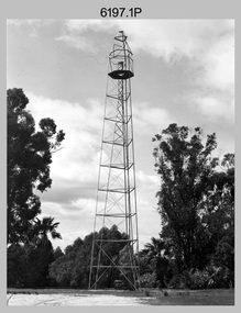
Photograph - Royal Australian Survey Corps Survey Observation Towers, c1950s
... operations. c1950s. Survey observation towers were used mainly to take angular measurements in flat or heavily forested terrain, where height was necessary to achieve observer’s line-of-sight between field survey station. The Bilby Tower seen in photo .5P was erected to a height of 75 feet (23m) above ground...operations. c1950s. Survey observation towers were used mainly to take angular measurements in flat or heavily forested terrain, where height was necessary to achieve observer’s line-of-sight between field survey station. The Bilby Tower seen in photo .5P was erected to a height of 75 feet (23m) above ground ...This is a set of seven photographs of Royal Australian Survey Corps surveyors setting up observation towers in the field and undertaking survey observations during mapping and geodetic control operations. c1950s. Survey observation towers were used mainly to take angular measurements in flat or heavily forested terrain, where height was necessary to achieve observer’s line-of-sight between field survey station. The Bilby Tower seen in photo .5P was erected to a height of 75 feet (23m) above ground level. The use of the Bilby Tower in Topographic Squadron’s field survey operations from 1955 to 1966 is described in page 54 of Valerie Lovejoy’s book 'Mapmakers of Fortuna – A history of the Army Survey Regiment’ ISBN: 0-646-42120-4. CAPT George Ricketts’ period of service was from 1942 to 1976 reaching the rank of LTCOL. It is noted in page 35 of Valerie Lovejoy’s book that then SGT Ricketts hand lettering skills came to the fore from his contribution to the draughting of one of the Japan’s Instruments of Surrender in 1945.This is a set of seven photographs of Royal Australian Survey Corps surveyors setting up observation towers in the field and undertaking survey observations during mapping and geodetic control operations. c1950s. The photographs were printed on photographic paper and are part of the Army Survey Regiment’s Collection. The photographs were scanned at 300 dpi. .1) - Photo, black & white, c1950s, ‘Bilby’ survey observation tower. .2) - Photo, black & white, c1950s, CAPT George Ricketts climbing ‘Bilby’ survey observation tower. .3) - Photo, black & white, c1950s, geodetic survey equipment on ‘Bilby’ survey observation tower. .4) - Photo, black & white, c1950s, two unidentified field surveyors on ‘Bilby’ survey observation tower. .5) - Photo, black & white, c1950s, two unidentified field surveyors, with CAPT Ricketts climbing ‘Bilby’ survey observation tower. .6) - Photo, black & white, c1950s, two unidentified field surveyors undertaking observations on survey observation tower. .7) - Photo, black & white, c1950, two unidentified field surveyors erecting or dismantling a survey observation tower..1P with paper tag annotated ‘Bilby Tower’ .4P on back – ‘Bilby Tower’. .5P on back – ‘Survey Observing Tower. Observing tower used for angular measurement in flat country. 75’ high – CAPT Ricketts climbing. .6P, .7P on back. ‘1960s?’royal australian survey corps, rasvy, army survey regiment, army svy regt, fortuna, asr, surveying -
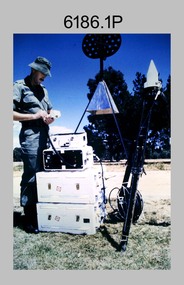
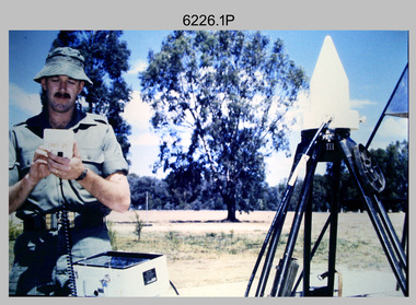 Bendigo Military Museum
Photograph - Demonstration of TI4100 GPS Receiver, Royal Australian Survey Corps, c1988
... operation of Global Positioning System equipment in c1988. The photos were probably taken at the School of Military Survey (SMS), Bonegilla, VIC. Texas Instruments TI4100 portable Global Positioning System (GPS) geodetic receivers were introduced from 1986–1988. The GPS receivers and Ferranti FILS3 helicopter and vehicle mounted Inertial Positioning System (IPS) replaced the TRANSIT satellite receivers. The equipment was deployed to establish the baseline for a GPS controlled air camera and photogrammetric system to significantly reduce the requirement for ground...operation of Global Positioning System equipment in c1988. The photos were probably taken at the School of Military Survey (SMS), Bonegilla, VIC. Texas Instruments TI4100 portable Global Positioning System (GPS) geodetic receivers were introduced from 1986–1988. The GPS receivers and Ferranti FILS3 helicopter and vehicle mounted Inertial Positioning System (IPS) replaced the TRANSIT satellite receivers. The equipment was deployed to establish the baseline for a GPS controlled air camera and photogrammetric system to significantly reduce the requirement for ground ...This is a set of four photographs of WO2 Graham Ragless from the Royal Australian Survey Corps demonstrating the operation of Global Positioning System equipment in c1988. The photos were probably taken at the School of Military Survey (SMS), Bonegilla, VIC. Texas Instruments TI4100 portable Global Positioning System (GPS) geodetic receivers were introduced from 1986–1988. The GPS receivers and Ferranti FILS3 helicopter and vehicle mounted Inertial Positioning System (IPS) replaced the TRANSIT satellite receivers. The equipment was deployed to establish the baseline for a GPS controlled air camera and photogrammetric system to significantly reduce the requirement for ground survey to accurately control air photography for topographic mapping. Personnel from the four field survey squadrons at this time were trained at the SMS to operate the TI4100 receivers. Field survey operations using GPS and IPS equipment followed in the late 1980s. This technology is described in more detail in the RA Svy booklet titled An Introduction to Topographic Mapping. See record ID - 6010. WO2 Graham Ragless progressed to the rank of WO1 and was appointed as RSM of the Army Survey Regiment from 1990 to 1992. Refer to item 6186.2P for more photographs of WO2 Graham Ragless demonstrating the TI4100.This is a set of four photographs of a technician from the Royal Australian Survey Corps demonstrating the operation of Global Positioning System equipment in c1988. Colour photos are on 35mm slide film and were scanned at 96 dpi. .1) to .4) - Photo, colour, c1988, WO2 Graham Ragless demonstrating the operation of a TI4100 GPS receiverThere are no annotations.royal australian survey corps, rasvy, army survey regiment, army svy regt, fortuna, asr, surveying -
 Bendigo Military Museum
Photograph - Johnson Ground Elevation Meter (JGEM) Survey Vehicle - Army Survey Regiment, Fortuna, Bendigo, c1960s
... SGT Geoff Briggs. .12) - Photo, colour, c1960s, JGEM levelling scope, levelling staff, unidentified technicians. .13) & .14) - Photo, colour, c1960s, JGEM levelling scope, unidentified technician. .15) & .16) - Photo, colour, c1960s, probably survey operation adjusted height plotted on block base sheet. Johnson Ground Elevation Meter (JGEM) Survey Vehicle - Army Survey Regiment, Fortuna, Bendigo. ...This is a set of 16 photograph of the Royal Australian Survey Corps’ Johnson Ground Elevation Meter (JGEM) Survey Vehicle taken at the Army Survey Regiment, Fortuna, Bendigo. The JGEM vehicle was extensively used by RA Svy within Australia from the late 1960s. A limited number of Ground Elevation Meter (GEM) station wagon type vehicles were manufactured by General Motors Corporation (GMC) in the USA for the United States Geological Survey, Canada’s mapping agencies, RA Svy and National Mapping (Natmap). The GEM was a four-wheel drive, four-wheel steer vehicle. Four-wheel steering was necessary to avoid systematic errors caused by non-tracking of front and rear wheels on conventionally steered vehicles. The manufacturer substituted the rear axle with a front axle and connected them to form the four-wheel steering mechanism. The two Australian GEM vehicles, referred to as Johnson GEMs (JGEMs) were converted into right-hand drive. After delivery in 1964, acceptance Natmap and RA Svy testing and operator training was undertaken at the Army's School of Military Survey located at Balcombe, Victoria. A small fifth wheel was mounted on a cantilever arm suspension midway between the front and rear wheels on the right side of the vehicle. It was lowered to and raised from its operating position by use of a constant pressure air cylinder. A telescopic bar, suspended between the front and rear axles, provided the reference datum for the angle measurement. The wheel provided the velocity or distance signal through a pulse generator system. A sensitive pendulum mounted on this bar provided the angle measurement for each minute distance traversed. The JGEM contained electromechanical instruments used to determine relative elevations, by trigonometric principles, along a traversed path. These relative elevations were obtained through apparatus which measures the instantaneous angle of inclination of the road and the instantaneous velocity of the meter along such a path. Road routes over which the JGEM operated were planned so that each started and ended as near as practicable to an existing point of known elevation (formally referred to as a level traverse bench mark). The difference in height from the bench mark and the road surface alongside the JGEM’s fifth wheel was measured with a level and staff. Along each route, mapping control photo reference points where new elevation values were required were identified on aerial photographs. Under favourable conditions it was possible to survey as much as 160km in an ordinary working day. The first of RA Svy’s JGEM operations was undertaken in 1:250,000 scale map areas of Queensland. CPL John Hook was the JGEM’s main operator in the early 1970s undertaking operations covering 1:250,000 scale map blocks over northern Victoria and central NSW, each requiring 36 points (9 runs of photography and 4 points across. SPR Lyn Thompson and SPR Bob McDonagh teamed with CPL Hook on some of these JGEM operations. When RA Svy was integrated into the Royal Australian Engineers in 1996, the JGEM vehicle with the Survey Corps collection was donated to its museum. It is believed to be the last of the original manufactured fleet in existence. The JGEM has undergone extensive refurbishment to achieve roadworthiness and is currently housed at The Australian Army Museum of Military Engineering, Hoslworthy Barracks, NSW. It can be viewed by making an appointment with the museum’s curator.This is a set of 16 photograph of the Royal Australian Survey Corps’ Johnson Ground Elevation Meter (JGEM) Survey Vehicle taken at the Army Survey Regiment, Fortuna, Bendigo. The photographs were on 35mm slide film and were scanned at 96 dpi. They are part of the Army Survey Regiment’s Collection. .1) - Photo, colour, c1960s, Johnson Ground Elevation Meter (JGEM) Survey Vehicle .2) - Photo, colour, c1960s, JGEM instrumentation, on-board computer. .3) - Photo, colour, c1960s, JGEM instrumentation. .4) - Photo, colour, c1960s, JGEM instrumentation, on-board computer. .5) - Photo, colour, c1960s, JGEM tyre pressure controller .6) - Photo, colour, c1960s, JGEM rear doors, SGT Geoff Briggs. .7) - Photo, colour, c1960s, JGEM 5th wheel distance/angle measurement device in lowered position, SGT Geoff Briggs. .8) - Photo, colour, c1960s, JGEM 5th wheel distance/angle measurement device in lowered position. .9) & .10) - Photo, colour, c1960s, JGEM tyre pressure system, SGT Geoff Briggs. .11) - Photo, colour, c1960s, JGEM tyre pressure system. SGT Geoff Briggs. .12) - Photo, colour, c1960s, JGEM levelling scope, levelling staff, unidentified technicians. .13) & .14) - Photo, colour, c1960s, JGEM levelling scope, unidentified technician. .15) & .16) - Photo, colour, c1960s, probably survey operation adjusted height plotted on block base sheet. .1P to .16P - Some of the equipment is annotated on the frame of the 35mm slides.royal australian survey corps, rasvy, army survey regiment, army svy regt, fortuna, asr, surveying -
 Bendigo Military Museum
Photograph - Royal Australian Survey Corps Aerial Surveys, c1980
... operations. Photo .9P was taken at a survey station at an unknown location. In this photo an Australian Army Kiowa Light Observation Helicopter (LOH) is supporting a field survey party undertaking Magnavox AN/PRR-14 portable Doppler satellite observations. The satellite receiver’s antenna is plumbed over the survey ground...operations. Photo .9P was taken at a survey station at an unknown location. In this photo an Australian Army Kiowa Light Observation Helicopter (LOH) is supporting a field survey party undertaking Magnavox AN/PRR-14 portable Doppler satellite observations. The satellite receiver’s antenna is plumbed over the survey ground ...This is a set of nine photographs of technicians from the Royal Australian Survey Corps operating aerial surveys equipment c1980s. In photo .1P, CPL Steve Gloster was operating a RC10 air survey camera mounted in an Australian Army Pilatus Porter aircraft. The Wild RC10 super wide-angle air survey cameras were first introduced in 1971, were equipped with virtual distortion free lenses for supplementary, spot and special photography. In photo .2P, Roger Rees was operating Air Profile Recorder (APR) equipment. it was possibly taken during OP NERVOSE 84, sometime between June – August 1984 when based in Ngukurr, Northern Territory. The APR was operated at this time in unison with an RC10 camera. In 1963 the Royal Australian Survey Corps introduced the radar airborne profile recorder (Canadian Applied Research Ltd, Mark V, Airborne Profiler Recorder) was introduced for 1:100,000 mapping to replace terrain heighting by aneroid barometry. Later in 1974-1975, the Australian developed WREMAPS II airborne laser terrain profile recorder was introduced. In photo .3P, Neil Jones appears at the door of Airsearch Beechcraft Queen Air aircraft, Registration / Serial VH-MWX. This aircraft was typically used by RA Svy on air survey operations flying mission with Aerodist, APR and RC10 camera equipment. The Australian Army’s Pilatus Porter (short take-off and landing turbo propeller) was also equipped with a Wild RC10 aerial mapping camera for identification photography. The Pilatus Porter was also used on RA Svy’s map field checking operations. Photo .9P was taken at a survey station at an unknown location. In this photo an Australian Army Kiowa Light Observation Helicopter (LOH) is supporting a field survey party undertaking Magnavox AN/PRR-14 portable Doppler satellite observations. The satellite receiver’s antenna is plumbed over the survey ground mark surrounded by white plastic panels. The panels were used to identify the survey station on aerial photography. Introduced in 1974–1975, the Magnavox AN/PRR-14 portable Doppler satellite (US Navy Navigation Satellite System – TRANSIT) receivers and computing system provided independent three-dimensional point positions anywhere in the world, anytime, in any weather accurate to about 1.5metres with precise satellite ephemerides. The Bell OH-58 Kiowa LOH was a family of military helicopters used for observation, utility, and direct fire support. It was identified by RA Svy in the mid-1970s that considerable time was lost in replacing unserviceable remote equipment by road. Therefore Aerodist operations (pre-dating satellite receiver operations) were fully supported by Army’s Kiowa LOH aircraft. This is a set of nine photographs of technicians from the Royal Australian Survey Corps operating aerial surveys equipment c1980s. .1P to .3P, .5P to .9P - Colour and black and white photos on photographic paper and scanned at 300 dpi. .4P - Colour photo on 35mm slide film and scanned at 96 dpi. .1) & .2) - Photo, black & white, c1980s, CPL Steve Gloster operating an RC10 air camera. .3) - Photo, colour, 1984, Roger Rees operating Air Profile Recorder (APR) equipment. .4) - Photo, colour, c1980s, Neil Jones at the door of an Airsearch Beechcraft Queen Air aircraft, typically used by RA Svy on air survey operations. .5) - Photo, colour, c1980s. A Beechcraft King Air aircraft, also used by RA Svy on air survey operations. .6) - Photo, colour, c1980s. An Australian Army Pilatus Porter, used by RA Svy on air survey and map field checking operations. SGT Peter Mustart is possibly in the foreground. .7) to .8) - Photo, colour, c1980s. An Australian Army Pilatus Porter and unidentified personnel, used by RA Svy on air survey and map field checking operations. .9) - Photo, colour, c1980s. An Australian Army Kiowa helicopter supporting a field survey party undertaking Magnavox AN/PRR-14 portable Doppler satellite observations. There are biro marks on photos .4P to .9Proyal australian survey corps, rasvy, army survey regiment, asr, fortuna, aerial surveys -
 Bendigo Military Museum
Photograph - Demonstration of TI4100 GPS Receiver, Royal Australian Survey Corps, c1988
... operation of Global Positioning System equipment in c1988. The photos were probably taken at the School of Military Survey (SMS), Bonegilla, VIC. Texas Instruments TI4100 portable Global Positioning System (GPS) geodetic receivers were introduced from 1986–1988. The GPS receivers and Ferranti FILS3 helicopter and vehicle mounted Inertial Positioning System (IPS) replaced the TRANSIT satellite receivers. The equipment was deployed to establish the baseline for a GPS controlled air camera and photogrammetric system to significantly reduce the requirement for ground...operation of Global Positioning System equipment in c1988. The photos were probably taken at the School of Military Survey (SMS), Bonegilla, VIC. Texas Instruments TI4100 portable Global Positioning System (GPS) geodetic receivers were introduced from 1986–1988. The GPS receivers and Ferranti FILS3 helicopter and vehicle mounted Inertial Positioning System (IPS) replaced the TRANSIT satellite receivers. The equipment was deployed to establish the baseline for a GPS controlled air camera and photogrammetric system to significantly reduce the requirement for ground ...This is a set of two photographs of WO2 Graham Ragless from the Royal Australian Survey Corps demonstrating the operation of Global Positioning System equipment in c1988. The photos were probably taken at the School of Military Survey (SMS), Bonegilla, VIC. Texas Instruments TI4100 portable Global Positioning System (GPS) geodetic receivers were introduced from 1986–1988. The GPS receivers and Ferranti FILS3 helicopter and vehicle mounted Inertial Positioning System (IPS) replaced the TRANSIT satellite receivers. The equipment was deployed to establish the baseline for a GPS controlled air camera and photogrammetric system to significantly reduce the requirement for ground survey to accurately control air photography for topographic mapping. Personnel from the four field survey squadrons at this time were trained at the SMS to operate the TI4100 receivers. Field survey operations using GPS and IPS equipment followed in the late 1980s. This technology is described in more detail in the RA Svy booklet titled An Introduction to Topographic Mapping. See record ID - 6010. WO2 Graham Ragless progressed to the rank of WO1 and was appointed as RSM of the Army Survey Regiment from 1990 to 1992. Refer to item 6226.4P for more photographs of WO2 Graham Ragless demonstrating the TI4100.This is a set of two photographs of a technician from the Royal Australian Survey Corps demonstrating the operation of Global Positioning System equipment in c1988. Colour photos are on 35mm slide film and were scanned at 96 dpi. .1) and .2) - Photo, colour, c1988, WO2 Graham Ragless demonstrating the operation of a TI4100 GPS receiverThere are no annotations.royal australian survey corps, rasvy, army survey regiment, army svy regt, fortuna, asr, surveying -
 Bendigo Military Museum
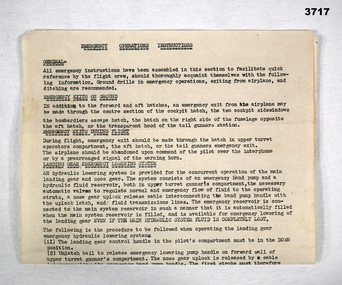
Document - DOCUMENT - AIRCRAFT EMERGENCY OPERATIONS INSTRUCTIONS, c.WWII
... Topics: General, Emergency Exits on Ground, Emergency Exits During Flight, Landing Gear Emergency Lowering System, Emergency Hydrulic Operation of Main Landing Gear Down Position Latches, Caution....Document RAAF WW2 In black type at top: EMERGENCY OPERATIONS INSTRUCTIONS Foolscap size, typed instructions, single sided. Topics: General, Emergency Exits on Ground, Emergency Exits During Flight, Landing Gear Emergency Lowering System, Emergency Hydrulic Operation of Main Landing Gear Down Position Latches, Caution. ...Item in the collection of Arthur Thomas MANLY No 431130 RAAF. Refer Cat No 3710 for his service details.Foolscap size, typed instructions, single sided. Topics: General, Emergency Exits on Ground, Emergency Exits During Flight, Landing Gear Emergency Lowering System, Emergency Hydrulic Operation of Main Landing Gear Down Position Latches, Caution.In black type at top: EMERGENCY OPERATIONS INSTRUCTIONSdocument, raaf, ww2 -
 Bendigo Military Museum
Photograph - 4th Field Survey Squadron deployed on Operation NERIGHT, Queensland & Northern Territory, 1989
... operations. .4) to .5) - Photo, colour, 1989. Unidentified personnel relax next to river/waterhole. .6) - Photo, colour, 1989. Two Bell UH-1H Iroquois helicopters from RAAF’s 35 SQN utilised in the movement of GPS parties. .7) to .9) - Photo, colour, 1989. Unidentified soldier practices repelling from a UH1H Iroquois helicopter. .10) - Photo, colour, 1989. Inside the cockpit of a UH1H Iroquois helicopter. .11) - Photo, colour, 1989. Field Party camp with GPS equipment in foreground. Unidentified soldier prepares a meal. .12) - Photo, colour, 1989. GPS antenna plumbed over a survey ground...operations. .4) to .5) - Photo, colour, 1989. Unidentified personnel relax next to river/waterhole. .6) - Photo, colour, 1989. Two Bell UH-1H Iroquois helicopters from RAAF’s 35 SQN utilised in the movement of GPS parties. .7) to .9) - Photo, colour, 1989. Unidentified soldier practices repelling from a UH1H Iroquois helicopter. .10) - Photo, colour, 1989. Inside the cockpit of a UH1H Iroquois helicopter. .11) - Photo, colour, 1989. Field Party camp with GPS equipment in foreground. Unidentified soldier prepares a meal. .12) - Photo, colour, 1989. GPS antenna plumbed over a survey ground ...This is a set of 19 photographs taken in 1989 during 4th Field Survey Squadron’s deployment on Operation NERIGHT 89 in Queensland and the Northern Territory. It was a two-part operation in 1989 with work conducted in the areas of Camooweal and Weipa. Part 1 was the field completion of topographic maps conducted near Camooweal QLD, along the Barkley Highway on the border between NT and QLD, from the 12th of September to the 20th of October 1989. A Bell Kiowa LOH helicopter from 162 Recce Sqn supported topographic field completion. Operation NERIGHT 89 Part 2 was the acquisition of mapping control by GPS field parties utilising Texas Instruments TI4100 Global Positioning System receivers around Weipa on Cape York Peninsula from the 22nd of September to the 22nd of October 1989. Part 2 Two Bell UH-1H Iroquois helicopters from RAAF’s 35 Squadron were principally used to deploy GPS field parties. Identification photography of control points was taken by air camera operators in AAAvn Pilatus Porter aircraft from 173 Gen Spt Sqn fitted with an RC10 aerial camera. The two parts of the operation were conducted concurrently. This is a set of 19 photographs taken in 1989 during 4th Field Survey Squadron’s deployment on Operation Neright in Queensland & the Northern Territory. The colour photographs are on 35mm negative film and are part of the Army Survey Regiment’s Collection. The photographs were scanned at 96 dpi. .1) to .3) - Photo, colour, 1989. En-route to areas of survey operations. .4) to .5) - Photo, colour, 1989. Unidentified personnel relax next to river/waterhole. .6) - Photo, colour, 1989. Two Bell UH-1H Iroquois helicopters from RAAF’s 35 SQN utilised in the movement of GPS parties. .7) to .9) - Photo, colour, 1989. Unidentified soldier practices repelling from a UH1H Iroquois helicopter. .10) - Photo, colour, 1989. Inside the cockpit of a UH1H Iroquois helicopter. .11) - Photo, colour, 1989. Field Party camp with GPS equipment in foreground. Unidentified soldier prepares a meal. .12) - Photo, colour, 1989. GPS antenna plumbed over a survey ground mark. Witness post on left. .13) & .14) - Photo, colour, 1989. Unknown Cape York Peninsula beaches. .15) & .16) - Photo, colour, 1989. Dramatic fire next to base camp. .17) - Photo, colour, 1989. Aboriginal rock art at unknown location. .18) - Photo, colour, 1989. Aboriginal rock art at unknown location. L to R: unidentified, SPR Andrew Quin. .19) - Photo, colour, 1989. Aboriginal rock art at unknown location. LT Chris Topovsek..1P to .19P – There are no personnel identified. ‘1989 OP NERIGHT’ annotated on negative sleeve.royal australian survey corps, rasvy, 4 fd svy sqn, op neright 89 -
4th/19th Prince of Wales's Light Horse Regiment Unit History Room
Flag, 173rd Airborne Brigade (US)
... ground combat unit in that war. Upon arrival, the 1st Battalion of the Royal Australian Regiment (1 RAR) and a battery from New Zealand (161Royal NZ Artillery) were attached to the Brigade -- making the 173d Airborne the only multi-national combat unit in the war. Initially headquartered in Bien Hoa, the Brigade operated in the four provinces around Saigon. (Xuan Loc, Long Khanh, Phuoc Long & Phuoc Tuy), but (in its roll as a "Fire Brigade") also went to the Central Highlands (Pleiku / Kontum) to fight Viet Cong. The 173d also conducted constant operations...ground combat unit in that war. Upon arrival, the 1st Battalion of the Royal Australian Regiment (1 RAR) and a battery from New Zealand (161Royal NZ Artillery) were attached to the Brigade -- making the 173d Airborne the only multi-national combat unit in the war. Initially headquartered in Bien Hoa, the Brigade operated in the four provinces around Saigon. (Xuan Loc, Long Khanh, Phuoc Long & Phuoc Tuy), but (in its roll as a "Fire Brigade") also went to the Central Highlands (Pleiku / Kontum) to fight Viet Cong. The 173d also conducted constant operations ...173 AIRBORNE BRIGADE (SEPARATE) US ARMY 1 RAR BATTLE GROUP BIEN HOA 1965-1966 On May 5, 1965, the Brigade deployed to South Viet Nam as the first US Army ground combat unit in that war. Upon arrival, the 1st Battalion of the Royal Australian Regiment (1 RAR) and a battery from New Zealand (161Royal NZ Artillery) were attached to the Brigade -- making the 173d Airborne the only multi-national combat unit in the war. Initially headquartered in Bien Hoa, the Brigade operated in the four provinces around Saigon. (Xuan Loc, Long Khanh, Phuoc Long & Phuoc Tuy), but (in its roll as a "Fire Brigade") also went to the Central Highlands (Pleiku / Kontum) to fight Viet Cong. The 173d also conducted constant operations against the southern stronghold of the VC Main Force in the legendary Iron Triangle in War Zone D. The brigade was organized as a balanced airborne combat force consisting of two infantry battalions, an artillery battalion, a support battalion, an engineer company, a cavalry troop, an armour company, and a headquarters company. Upon activation, it became the first and only separate airborne brigade in the United States Army. This was the beginning of a long series of "Firsts" for the Brigade. On 5 May 1965, it became the first US Army ground combat unit committed to the war in South Vietnam, where further organizational changes were to take place. Australians attached to the Brigade were: 1st Battalion, of the Royal Australian Regiment (I RAR) and support troops of the 4/19th Prince of Wales Light Horse Regiment (1Troop), 105 Field Battery Royal Australian Artillery, 161 Field Battery Royal New Zealand Artillery, 3 Field Troop Royal Australian Engineers, 161 Reconnaissance Flight, Royal Australian Army Air Corps, 1st Australian Logistical Support Company. The Brigade's two infantry battalions, the First Battalion of the 503' Infantry (1/503`d) and the Second Battalion, of the 503`d Infantry (2/503`) and the attached Australians of 1 RAR constituted the infantrymen available to the Brigade. Their mission was to protect the Bien Hoa Air Base and to close with and destroy or capture the enemy. This was in fact the first operational ground force formed under the ANZUS Defence Treaty. ANZUS was a mutual defence treaty signed in 1951 between Australia, New Zealand and the United States of America. In 1965 the spirit of this treaty appeared as 173d Airborne Brigade (Sep) a tri-national brigade. The only such tri-national fighting force formed during the Vietnam War. On deployment to South Vietnam in 1965, 1 Troop A Squadron, 4th/19th Prince of Wales's Light Horse Regiment was part of the US 173rd Airborne Brigade combat group. Flag, two colours divided vertically, hoist half mid blue, fly half red. Badge of 173rd Airborne Brigade (730 x 490 mm) in centreflag, 173rd airborne, south vietnam -
 Lara RSL Sub Branch
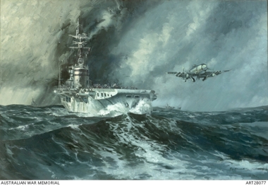
Mounted print of H.M.A.S.Sydney in Korean waters
... The Sydneys' role consisted predominantly of direct attacks on ground targets and assistance to ground operations. Sydney can be seen here launching Hawker Sea Fury fighters from the Nos. 805 and 808 Squadrons with Fairey Firefly on deck. korean war h.m.a.s.. sydney navy lara r.s.l. ...The HMAS Sydney in Korean waters launching Hawker Sea Fury fighters. The HMAS Sydney is flanked on either sides by her destroyer escorts HMAS Tobruk, and HMCS Sioux. A rescue helicopter is hovering above the Sydney.HMAS Sydney joined United Nations forces in Korean waters in October 1951. The Sydneys' role consisted predominantly of direct attacks on ground targets and assistance to ground operations. Sydney can be seen here launching Hawker Sea Fury fighters from the Nos. 805 and 808 Squadrons with Fairey Firefly on deck.Mounted print of H.M.A.S.Sydney in Korean watersRay Honisett H.M.A.S.Sydney in Korean waters.1951_52 1975 oil on canvas 121.9 x 182.9cm Australian War Memorial (28077) Telegraphist E.LOGAN R.A.N. R51533 1957/58korean war, h.m.a.s.. sydney, navy, lara r.s.l. -
 Bendigo Military Museum
Uniform - CLOTH BADGES, RAAF, 1939-45
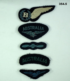
... ground staff No. From 12.2.1942 to 12.9.43 he went through various courses at Sale, Lake Boga, Somerset, Richmond and Adelaide. Finally accepted into Aircrew he embarked from Melbourne for Canada for training as a Bomb Aimer on 27.9.1943, arriving Canada via San Francisco 19.10.1943. He then attended Bomb Aimers Courses at Mossbank and Edmonton. Granted a Commission as a Flying Officer on 24.3.1943, embark for England 10.4.1944 and posted to various bases for advanced training. Finally on 7.3.1945 he is posted to No 462 Sqd RAAF flying Halifax Bombers in Bomber Command and begins operations...ground staff No. From 12.2.1942 to 12.9.43 he went through various courses at Sale, Lake Boga, Somerset, Richmond and Adelaide. Finally accepted into Aircrew he embarked from Melbourne for Canada for training as a Bomb Aimer on 27.9.1943, arriving Canada via San Francisco 19.10.1943. He then attended Bomb Aimers Courses at Mossbank and Edmonton. Granted a Commission as a Flying Officer on 24.3.1943, embark for England 10.4.1944 and posted to various bases for advanced training. Finally on 7.3.1945 he is posted to No 462 Sqd RAAF flying Halifax Bombers in Bomber Command and begins operations ...The patches and insignia belonged to Arthur COWLEY RAAF. (Born Collingwood, enlisted Melbourne) on 22.1.1942 age 18 years 6 months as No 50704 which was a ground staff No. From 12.2.1942 to 12.9.43 he went through various courses at Sale, Lake Boga, Somerset, Richmond and Adelaide. Finally accepted into Aircrew he embarked from Melbourne for Canada for training as a Bomb Aimer on 27.9.1943, arriving Canada via San Francisco 19.10.1943. He then attended Bomb Aimers Courses at Mossbank and Edmonton. Granted a Commission as a Flying Officer on 24.3.1943, embark for England 10.4.1944 and posted to various bases for advanced training. Finally on 7.3.1945 he is posted to No 462 Sqd RAAF flying Halifax Bombers in Bomber Command and begins operations from Foulsham. Arthur completes 8 missions before the war is over with Germany. Departs England 28.11.1945 for Australia and is discharged on 11.1.1946. .1) Bomb Aimers Wings, Cloth, dark blue background with White "B" and Wing. .2) Shoulder Badge, cloth, dark blue with light blue "Australia"& Eagle. .3) Rank Badge, light blue propellor on dark blue background. .4) Badge Shoulder, cloth, Australia light blue on a dark background. .5) Badge Shoulder, cloth, light blue eagle on a dark blue background.air force, raaf, badges uniform -
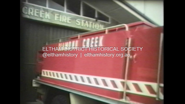 Eltham District Historical Society Inc
Film - Video (VHS), Diamond Creek Fire Brigade, c.1955-1987
... Footage features the Shire of Eltham War Memorial tower at Kangaroo Ground before it was modified with a fire spotter’s cabin. Discusses fire spotting operations from the tower. ...Footage features the Shire of Eltham War Memorial tower at Kangaroo Ground before it was modified with a fire spotter’s cabin. Discusses fire spotting operations from the tower. ...Combination of three movie films. Movie One (1950s): 00:00 – 13:14 Black and white footage of Diamond Creek firemen practising in Diamond Street in the 1950s for forthcoming demonstrations of abilities. Mentions of Gordon Brandy and Joe Hislop Running out hoses from old hose reels along Diamond Street, Diamond Creek Displays from various brigades running out and connecting hoses. Also scenes from the 1950s of Diamond Creek Fire Brigade competing in various locations around Victoria and Tasmania. Mentions of Brigade members Dave Kidd, Bruce Hackett, Ron Kirkbride, Jack Marks, Graham Upton who are prominent in these events. Members of Kyneton Fire Brigade also present. Members competing in running out hose reels, connecting hoses togethers and to hydrants then climbing towers to direct water from hose or at a target hanging above the road. Diamond Creek members identified wearing a diamond on their chest and back. Includes scenes of Scottish pipe bands at the events and significant crowds of spectators. Footage of Mel Stone and Beryl Marks, Stan Redpath and Ron Kirkbride, then Ron Kirkbride and Eric Holt viewing flower displays. Film changes to colour at Diamond Creek oval for practice with fire engine entering oval. Members depicted include Bill May, Jack Sinclair, Jim Cox, Bob Beale, Dave Kidd, Bruce Hackett and Captain Clarrie Stone. Reverts to black and white in the 1950s where the Brigade joins forces with the Diamond Valley Community Hospital for a Gala Day on the Diamond Creek Oval. Changes to colour again, possibly same event and scenes of children on bikes and scooters or with prams and carts racing around the oval. Mention of young lad Brian Laurie who has his own fire truck. Dart throwing, pony rides. Scenes with Dr Don Cordner, Gus Lyons, Vic Cohn (?) and spinning wheel and Diamond Creek School children entertain a large crowd with Maypole dancing. Movie Two (1950s): 13:25 – 19:00 This black and white film was taken by a TV film crew in the 1950s depicts a typical call out for the Diamond Creek Fire Brigade. In this case the careless action of a member of the public throwing a lighted match from a car, which can cause extensive damage. Footage features the Shire of Eltham War Memorial tower at Kangaroo Ground before it was modified with a fire spotter’s cabin. Discusses fire spotting operations from the tower. Shows a fire spotter walking around the top of the tower. A fire is detected, and the information is relayed to the nearest fire station, in this case, Diamond Creek. The telephone call is received, and the alarm sounded. Captain Clarrie Stone and firemen May and Shaw leave their workplaces and prepare for action. Scenes of running across the Main Hurstbridge road showing the shops (Shell service station and Chemist prominent). Scenes entering the fire station which has a pictorial warning covering the entire door “Only you can prevent forest fires – If you’re careless – we’re homeless!” Eric Holt pinpoints the location of the fire while Captain Clarrie Stone and Fireman Shaw take note. The advance vehicle (an FE Holden ute, rego GTE-696) leaves to assess the extent of the fire. Having assessed the fire, Fireman Shaw communicates with base showing radio with call sign VL3JZ. Eric Holt takes the call. In the meantime, Captain Clarrie Stone and Fireman Shaw undertake some limited action to address the fire. Firemen Bill May, Jim Bates and Hugh Bar (?) man the tanker. A photo portrait of Queen Elizabeth is visible hanging on the wall. They are later joined by Firemen Jim Cox, Eric DeBuse (?) and Jack Marks. The tanker is seen departing the station and diverging off before the bridge. Captain Clarrie Stone and Fireman Shaw are seen pumping water on the flames with hand pumps when the tanker arrives. The hose is unreeled, and water turned on the flames. Jack Sinclair joins the action. Jim Cox directs water to the high stuff. The fire put out, Jack Marks and Eric DeBuse wind in the hoses and the team head back to town. It’s peaceful again at the memorial tower. Movie Three (1969-1987): 19:14 – 34:34 Colour film “Fired with Dedication”, Country Fire Authority Victoria, produced by I.L. Wadeson, Commentary by A.M. Hem. Credits with CFA Victoria emblem and then placed over a view of an old-style ladder engine. Opens with the scene of a fire engine outside the Diamond Creek Fire Station then various trophies reflecting the competition success of the brigade in various track and disciplined events. Two trophies shown of particular pride to the brigade were for first place in the Torchlight Procession at the State Championships in Mildura in 1986 and also at Swan Hill in 1981. Still photo scenes of ex Captain Clarrie Stone, Brigade Captain for 21 years; ex Captain Jack Marks, 10 years; ex Captain Ian Douglas, 10 years. Cuts to scene of radio control room, January 1969, and news of a fire on the northern side of the township of Diamond Creek. With scenes of flames in bush, the narration explains that until the early 1960s the area was an orchard district which protected the town against the savagery of bushfires. But due to competition from other areas more suitable for orcharding and easier transport to Melbourne the district could no longer remain competitive, and orchards were replaced by grassed areas, which together with the bush areas were a feeding ground for fire. On 8th January 1969, high temperatures and strong north winds, were, with the carelessness of some individual all that was necessary to produce the worst fire the district had seen. Cuts to scene of blackened fields and cattle - Hundreds of hectares of grass land were blackened, and cattle had to be transported to other areas for agistment. Scene of destroyed buildings in the township – 13 houses and the public hall in the town were destroyed as was the theatre equipment which was owned by the fire brigade. The Church of England Hall and bell tower were badly damaged. The whole town could have been burnt out but for the determination, skill, and courage of the Diamond Creek Fire Brigade. Scenes of all that was left of the home on the hill on the west side of the Church of England. Also, the remains of the old Pisy (?) home on the top of the same hill near Lambert Street, and the ruined Crocker home. Cuts to a scene in the mid-1970s to mid-1980s of a house fire in Haley Street attended by the Diamond Creek Fire Brigade. Although the house was severely damaged, it was saved. Mentions that whilst assistance is appreciated, in some circumstances, those doing so are not properly dressed for fighting fires. Breathing apparatus is a must in structure fire attack. Next scene (either on Mangarook or Coventry oval) showing off four Diamond Creek Fire Brigade efficient and very expensive firefighting units. Features a forward control vehicle Toyota 4WD used for conveying task force personnel to the required areas; a Hino Model 3.2 tanker, diesel powered and carries 3,000 litres of water and has a 16 HP petrol driven pump which delivers 900 litres of water per minute; an International tanker (registration TCM-418) which carries 3,000 litres of water with pumping capacity of 600 litres per minute. The Ford diesel powered pumper (registration MXE-754) is a well-equipped vehicle with a water capacity of 1,000 litres and capable of pumping 1,900 litres of water per minute from the main pump, has many lockers which hose equipment such as breathing apparatus and various types of hose nozzles and foam making equipment. The vehicle carries 360m of 64mm diameter hose which can be laid out from the rear lockers and a portable lighting plant, an Oxy Viva resuscitator to revive smoke inhalation victims and forcible entry tools to gain access to structure fires. Views of the main pump and control panel on the vehicle. As well as the main pump, the vehicle is equipped with an auxiliary pump which allows the facility to pump whilst moving. Fire fighters must undergo constant training and hone their skills, Scenes of a training exercise using the pumper to pump from static water. First, the short lengths of suction hose are coupled, a strainer fitted to ensure debris does not foul the pump. Gauges must be constantly monitored to ensure manageable water pressures are maintained. Pressures are normally controlled to allow two fire fighters to work at each nozzle outlet. Two nozzles are tested, one adjustable jet fog type which is used on flammable gasses or within a structure fire to absorb heat. A straight jet nozzle to project water long distances to protect exposed surfaces close to a fire radiated heat. The pumper is quite a versatile vehicle in handling structure fires, but it also carries specialist equipment needed in containing hazardous chemical incidents. Cuts to scene of parade – the Diamond Creek Fire Brigade has with other neighbouring brigades participated in most town fairs and earns the respect of the watching public. It can be seen why this brigade has been so successful at disciplined contests. Views of Plenty Fire Brigade Road Rescue unit which is equipped with the “Jaws of Life” Scenes of athletic competitions – many neighbouring brigades indulge in friendly but keen competition at the Diamond Creek Town Fair. The young are also encouraged to participate in all aspects of Junior Fire Brigade activities and become tomorrow’s generation of volunteer fire fighters. Scene of the 1986 Diamond Creek Town Fair which was the last time veteran Captain Clarrie Stone BEM marched with the brigade. Clarrie was awarded the British Empire Medal for his service to the Country Fire Authority. Also, scenes of vehicles in the parade. Cuts to scene of brigade members in drill formation for inspection by Acting Chief Harry Rothsay (?) on the occasion of the opening of the new fire station extensions on August 29, 1987. Rudy Libel (?) Captain at the time. Scenes of crowds including many dignitaries of neighbouring brigades present including Lieutenant Gordon Grandy (who came down from Queensland for the occasion) and ex-Secretary David Kidd and wife Betty, also ex Captain Clarrie Stone and Mrs Nel Stone, a life member of the Ladies Auxiliary, the Reverend Jock Ryan, son of J.L Ryan, founder of the Diamond Creek Fire Brigade, Foundation Captain of the fire brigade, Keith Bradbury and Mrs Bradbury. Pauline Dick accepts a community service award for services to the CFA. Recognising over 47 and a half years of service, a presentation is made by Mr Neil Marshall, Acting Chairman of the CFA to ex Captain Clarrie Stone with response by Clarrie. Other members of the official party include Cr. Martin Wright, Shire President Wayne Phillips and local Member of Parliament, Mrs Pauline Toner. Ex foreman John Bennett is presented with a life member’s awards by Captain Rudy Libel. The camera also catches Gwen Cox, Jean Ryan and Bessie Layton (?) Provides historic footage of people, places and equipment and a record of the worst fires expoerienced in Diamond Creek in 1969BASF Standard Quality SQ E-180 VHS dubbing (poor quality) of three films Converted to MP4 file format 0:34:38, 1.85GBOn label: "Donation - August 2000 Diamond Creek Unit Old films made up from Fire Brigade shows at competitions - also Kangaroo Ground Tower being used"video recording, diamond creek fire brigade, 1986 diamond creek town fair, a.m. hem, acting chief harry rothsay, athletic competitions, beryl marks, bessie layton, betty kidd, bill may, bob beale, brian laurie, bruce hackett, captain clarrie stone, chemist, church of england hall, clarrie stone, clarrie stone bem, country fire authority victoria, coventry oval, cr. martin wright, crocker home, dart throwing, dave kidd, david kidd, diamond creek, diamond creek fire station, diamond creek oval, diamond creek school, diamond creek town fair, diamond street, diamond valley community hospital, dr don cordner, eric debuse, eric holt, fe holden ute, fire damage – buildings, fire spotter, fire spotter’s cabin, fire station extension, fired with dedication (film), firefighting units, fireman shaw, firemen jim cox, ford pumper, foundation captain, gala day, gordon brandy, gordon grandy, graham upton, gus lyons, gwen cox, haley street, hino model 3.2 tanker, house fire, i.l. wadeson, ian douglas, international tanker, j.l ryan, jack marks, jack sinclair, january 1969, jaws of life, jean ryan, jim bates and hugh bar, jim cox, joe hislop, john bennett, kangaroo ground, kangaroo ground tower, keith bradbury, kyneton fire brigade, lambert street, main hurstbridge road, mangarook oval, maypole dancing, mel stone, mildura 1986, mrs bradbury, mxe754 vic registration, neil marshall, nel stone, orchard district, oxy viva resuscitator, pauline dick, pauline toner mp, pisy home, plenty fire brigade road rescue unit, pony rides, radio control room, reverend jock ryan, ron kirkbride, rudy libel, shell service station, shire of eltham war memorial, shire president wayne phillips, spinning wheel, stan redpath, state championships, swan hill 1981, tcm418 vic registration, torchlight procession, toyota 4wd, trophies, vic cohn, victorian bushfires - 1969, vl3jz -
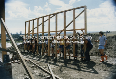 Eltham District Historical Society Inc
Photograph - Colour Print, SES members assisting with construction work on the Eltham Emergency Operations Centre and Kangaroo Ground Hall, 35 Kangaroo Ground-St Andrews Road, Kangaroo Ground, 1988
... Construction kangaroo ground hall mudbrick construction State Emergency Service (Eltham) Eltham Emergency Operations Centre 3 Colour print 10 x 15 cm Originally housed in a 34.5 x 36 x 2.5 cm expandable album with padded cream covers and gold accents; 18 page inserts with clear pocket inserts holding 6 photos per side, total capacity 216 10 x 15 cm photo prints; showing yellowing with age SES members assisting with construction work on the Eltham Emergency Operations Centre and Kangaroo Ground Hall, 35 Kangaroo Ground-St Andrews Road, Kangaroo Ground Photograph Colour Print ...Located at 35 Kangaroo Ground-St Andrews Road, Kangaroo Ground The centre was jointly funded by the Shire of Eltham, Community Employment Programme, Country Fire Authority and State Emergency Service. It was opened by the Shire President of the Shire of Eltham, Cr. Alan Baker, at a ceremony attended by Members of Parliament, Councillors, & Representatives of the Victoria Police, Country Fire Authority, State Emergency Service, Ambulance Service Melbourne, Salvation Army & residents of the Shire of Eltham on Saturday, 13 February 1988.construction, kangaroo ground hall, mudbrick construction, state emergency service (eltham), eltham emergency operations centre -
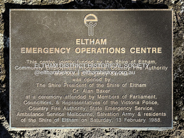 Eltham District Historical Society Inc
Photograph - Digital Photograph, Peter Pidgeon, Plaque, Eltham Emergency Operations Centre (and Kangaroo Ground Hall), 35 Kangaroo Ground-St Andrews Road, Kangaroo Ground, 5 July 2025
... Centre Salvation Army shire of eltham State Emergency Service (Eltham) Victoria Police Peter & Elizabeth Pidgeon Collection Born digital image file Plaque, Eltham Emergency Operations Centre (and Kangaroo Ground Hall), 35 Kangaroo Ground-St Andrews Road, Kangaroo Ground Photograph Digital Photograph Peter Pidgeon ...The dedication plaque, mounted on a rock near the flag pole at entrance reads: This centre, jointly funded by the Shire of Eltham, Community Employment Programme, Country Fire Authority and State Emergency Service was opened by The Shire President of the Shire of Eltham Cr. Alan Baker at a ceremony attended by Members of Parliament, Councillors, & Representatives of the Victoria Police, Country Fire Authority, State Emergency Servicve, Ambulance Service Melbourne, Salvation Army & residents of the Shire of Eltham on Saturday, 13 February 1988. See also: Kangaroo Ground Hall. (2025, July 5). Retrieved from https://www.nillumbik.vic.gov.au/Council/Facilities-and-property/Council-facilities-for-hire/Kangaroo-Ground-Hallkangaroo ground hall, mudbrick construction, nillumbik shire council property, ambulance service victoria, community employment program, country fire authority, cr. alan baker, eltham emergency operations centre, salvation army, shire of eltham, state emergency service (eltham), victoria police, peter & elizabeth pidgeon collection -
 Eltham District Historical Society Inc
Photograph, Memorial Tower, Kangaroo Ground c.1934, 1934c
... The work has been undertaken by the people of the Shire a a tribute of love and admiration for those who were known and dear to use in the days of their youth and early manhood, who went out from amongst us, never to return, and whose self-sacrifice has made us, each and all, thier ever-lasting debtors" Harry Gilham, Eltham District Historical Society Kangaroo Ground Tower of Remembrance, A Journey in Time: a column about Nillumbik's history, Nillumbik Mail, 9th August, 2000 Since that research the following has been sourced from Eltham and Whittlesea Shires Advertiser and Diamond Creek Valley Advocate, April 8, 1921, p. 3 Retrieved April 25, 2020, from http://nla.gov.au/nla.news-article57639687 Eltham Shire Council From Town Clerk, Melbourne, stating that a light machine-gun captured by the 22nd battalion, A.I.F. at La Motte Farm, near Beaurvoir, on Oct. 3rd, 1918, during the operations which won the Beauvoir line and completed the smashing of the great Hindenburg defence-system, has been alloted to the Shire of Eltham. - On the motion of Crs Hubbard and Smedley, it was decided to have the gun placed in the Memorial Park. ...The work has been undertaken by the people of the Shire a a tribute of love and admiration for those who were known and dear to use in the days of their youth and early manhood, who went out from amongst us, never to return, and whose self-sacrifice has made us, each and all, thier ever-lasting debtors" Harry Gilham, Eltham District Historical Society Kangaroo Ground Tower of Remembrance, A Journey in Time: a column about Nillumbik's history, Nillumbik Mail, 9th August, 2000 Since that research the following has been sourced from Eltham and Whittlesea Shires Advertiser and Diamond Creek Valley Advocate, April 8, 1921, p. 3 Retrieved April 25, 2020, from http://nla.gov.au/nla.news-article57639687 Eltham Shire Council From Town Clerk, Melbourne, stating that a light machine-gun captured by the 22nd battalion, A.I.F. at La Motte Farm, near Beaurvoir, on Oct. 3rd, 1918, during the operations which won the Beauvoir line and completed the smashing of the great Hindenburg defence-system, has been alloted to the Shire of Eltham. - On the motion of Crs Hubbard and Smedley, it was decided to have the gun placed in the Memorial Park. ...Sepia photograph of Joyce McMahon and 'Tiny' Carroll at the War Memorial Tower, Kangaroo Ground c.1934. The guns were installed in 1934 and removed in 1942. Taken in the early 1930s, the photograph ... shows the Kangaroo Ground Tower of Remembance with Joyce McMahon, daughter-in-law of Mr. P. J.McMahon, the then Shire of Eltham Secretary, her horse and a very tall person patting the horse. He is ex-serviceman W. "Tiny" Caroll who was the council's caretaker of the surrounding War Memorial Park. He lived in the stone cottage which still stands in the park. "Tiny" is seen as the fictional character "Tiny Bourke" who, in author Alan Marshall's book "This is the Grass", "was a giant of a man, well over six feet high, with huge hands that completely encircled the cup of tea". The bronze casting, which shows the 79 names of those who paid the "supremen sacrifice" in World War 1 (1914-1918), was erecfed above the entrance to the Tower in September, 1930. The Monterey cypress trees which now form the windbreak around the park's fenceline, were just knee high in this photograph. They were planted in August 1926, with all the plantings paid for, and done, by the public as the Tower was being erected. The two field guns have been identified as of German origin, Krupp 77 mm calibre captured on October 4, 1918 at Geneve, France. They were removed in 1943/44 as a wartime requirement of the Australian Govenment. A public notice dated October 16, 1926 by Cr. H Rutter, Chairman of the Eltham Soldiers War Memorial League stated: "On the summit of that central and conspicuous landmark, Garden Hill, there is being erected a massive memorial tower which will, for all time, remind every passerby of the part played by the men of the Shire of Eltham in the Great War. The work has been undertaken by the people of the Shire a a tribute of love and admiration for those who were known and dear to use in the days of their youth and early manhood, who went out from amongst us, never to return, and whose self-sacrifice has made us, each and all, thier ever-lasting debtors" Harry Gilham, Eltham District Historical Society Kangaroo Ground Tower of Remembrance, A Journey in Time: a column about Nillumbik's history, Nillumbik Mail, 9th August, 2000 Since that research the following has been sourced from Eltham and Whittlesea Shires Advertiser and Diamond Creek Valley Advocate, April 8, 1921, p. 3 Retrieved April 25, 2020, from http://nla.gov.au/nla.news-article57639687 Eltham Shire Council From Town Clerk, Melbourne, stating that a light machine-gun captured by the 22nd battalion, A.I.F. at La Motte Farm, near Beaurvoir, on Oct. 3rd, 1918, during the operations which won the Beauvoir line and completed the smashing of the great Hindenburg defence-system, has been alloted to the Shire of Eltham. - On the motion of Crs Hubbard and Smedley, it was decided to have the gun placed in the Memorial Park. Sepia Photographgarden hill, gun, joyce mcmahon, kangaroo ground, memorial tower, shire of eltham war memorial tower, tiny carroll, war memorials, war trophy, william carroll