Showing 5 items matching "h.c. crouch"
-
 Kew Historical Society Inc
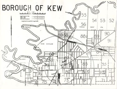
Plan, Borough of Kew, 1910
... ...h.c. crouch...The overhead transparency is of a map produced by H.C. Crouch Borough Surveyor in 1910...The overhead transparency is of a map produced by H.C. Crouch Borough Surveyor in 1910 The Rogers Collection provides a comprehensive insight into the working habits of a historian in the 1960s and 1970s. ...This work forms part of the collection assembled by the historian Dorothy Rogers, that was donated to the Kew Historical Society by her son John Rogers in 2015. The manuscripts, photographs, maps, and documents were sourced by her from both family and local collections or produced as references for her print publications. Many were directly used by Rogers in writing ‘Lovely Old Homes of Kew’ (1961) and 'A History of Kew' (1973), or the numerous articles on local history that she produced for suburban newspapers. Most of the photographs in the collection include detailed annotations in her hand. The overhead transparency is of a map produced by H.C. Crouch Borough Surveyor in 1910The Rogers Collection provides a comprehensive insight into the working habits of a historian in the 1960s and 1970s. Together it forms the largest privately-donated collection within the archives of the Kew Historical Society.An overhead transparency of a plan of Kew comparing the roads in 1860 with later roads constructed by 1910. Sections of the plan are marked with the location of particular buildings, farms or transport routes.Borough of Kewborough of kew, h.c. crouch -
 Ringwood and District Historical Society
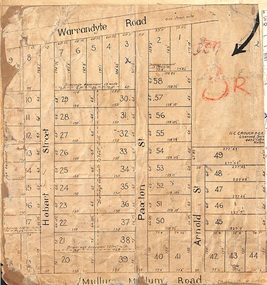
Map, Residential Subdivision Allotment Layout on Mullum Mullum Road, Hobart Street, Paxton Street, Arnold Street and Warrandyte Road, Ringwood, Vic. circa 1920
... H.C. Crouch, Licensed Surveyor, 443 Lt Collins Street, Melbourne....Ringwood and District Historical Society 125A Warrandyte Road Ringwood North melbourne H.C. Crouch, Licensed Surveyor, 443 Lt Collins Street, Melbourne. ...One of 3 unrelated land subdivision maps on cardboard backing.H.C. Crouch, Licensed Surveyor, 443 Lt Collins Street, Melbourne. -
 Ringwood and District Historical Society
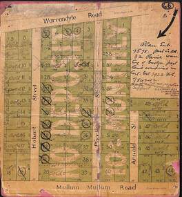
Map, Residential Subdivision Allotment Layout on Mullum Mullum Road, Hobart Street, Paxton Street, Arnold Street and Warrandyte Road, Ringwood, Vic. (Undated, circa 1920)
... H.C. Crouch, Licensed Surveyor, 443 Lt Collins Street, Melbourne. ...Ringwood and District Historical Society 125A Warrandyte Road Ringwood North melbourne H.C. Crouch, Licensed Surveyor, 443 Lt Collins Street, Melbourne. ...Map on cardboard backing clipped from Subdivision Plan 7578 - Part of Crown Allotment 32, Parish of Warrandyte, County of Evelyn.H.C. Crouch, Licensed Surveyor, 443 Lt Collins Street, Melbourne. Includes handwritten real estate sales notations and Certificate of Title reference - Vol 3922 Fol 784242. -
 Ringwood and District Historical Society
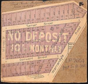
Map, The Ringwood Estate - Second Sub-Division, Ringwood, Victoria - 1919
... H.C. Crouch BCE, Licensed Surveyor, 443 LtCollins Street, Melbourne. ...Ringwood and District Historical Society 125A Warrandyte Road Ringwood North melbourne H.C. Crouch BCE, Licensed Surveyor, 443 LtCollins Street, Melbourne. ...Three cardboard-backed copies of map clipped from land sale auction brochure. Subdivision includes Warrandyte Road, Tamar Street, Mersey Street and Derwent Street.H.C. Crouch BCE, Licensed Surveyor, 443 LtCollins Street, Melbourne. Handwritten real estate notations in margins and on some allotments include sales information and reference LP7604 - Part of Crown Allotment 31B. Auction date June 14th, 1919. -
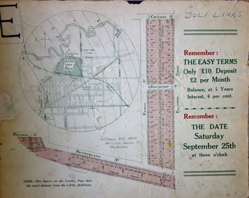 Kew Historical Society Inc
Plan - Subdivision Plan, H C Crouch, Old Golf Links Estate, 1930s
... The Plan identifies the surveyor (sic) H.C. Crouch BCE MVIS, 443 Little Collins St., Melbourne. ...The Plan identifies the surveyor (sic) H.C. Crouch BCE MVIS, 443 Little Collins St., Melbourne. ...The land in North Kew between the Outer Circle Railway and the River Yarra was released in sections. This release included 80 lots. Most of this area was released during the Depression years in the early 1930s.Subdivision plans are historically important documents used as evidence of the growth of suburbs in Australia. They frequently provide information about when the land was sold on which a built structure was subsequently constructed as well as evidence relating to surveyors and real estate and financial agents. The numerous subdivision plans in the Kew Historical Society's collection represent working documents, ranging from the initial sketches made in planning a subdivision to printed plans on which auctioneers or agents listed the prices for which individual lots were sold. In a number of cases, the reverse of a subdivision plan in the collection includes a photograph of a house that was also for sale by the agent. These photographs provide significant heritage information relating house design and decoration, fencing and household gardens.One part of a massive subdivision of the Old Golf Links Estate in North Kew of 80 allotments bordering Sutherland Avenue, Ramsay Avenue, Belford Road, Beresford Street and Coleman Avenue. Inset on the plan at the top left, the route of the Outer Circle Railway is clearly marked. The Kew Golf Links is identified in its current location. The land on which Greenacres Golf Club was to be constructed is at this time marked as ‘Recreation Ground’. The ‘new bridge’ over the Yarra at Burke Road is also marked on the inset map. The Plan identifies the surveyor (sic) H.C. Crouch BCE MVIS, 443 Little Collins St., Melbourne. The date of the subdivision auction sale in identified as Saturday September 25th at three o'clock.Annotations: "E" top left. "Golf Links" top right. Lots 73-76 ticked and listed as "6" poundssubdivisions -- kew (vic.), old golf links estate