Showing 757 items matching "high street -- kew east"
-
 Kew Historical Society Inc
Photograph - High Street, Kew East
... High Street, Kew East...High Street, Kew East in 1916 looking west. ..."High Street, East kew, near rail bridge."..., East kew, near rail bridge." High Street, Kew East in 1916 looking west. Photograph High Street, Kew East ...In 1980, Mr Laurie Bennett presented the Kew Historical Society with a number of photographs and postcards from the estate of his mother Eileen Mary Bennett (nee Clark). His mother was the daughter of Lawrence FH Clark(?-1946) and Mary Clark (?-1925) of 22 Harp Road, East Kew, in whose yard the photograph was taken. A year before the donation occurred a notice appeared in the Canberra Times stating that: "BENNETT, Eileen Mary. — May 8th at Tuross Heads, N.S.W. Late of 22 Harp Rd, East Kew, (Vic). Dearly loved wife of the late Harold Bennett, loved mother and mother in law of Laurie and Shirley (Melbourne), Kevin and Doreen (Canberra), grandmother of Linda, Stephen, Paul, Gabrielle, Peter, Mark and Jon."Part of a large collection of photographs and postcards in the collection. This dated photograph allows the researcher to identify development by 1916 in Kew and East Kew.High Street, Kew East in 1916 looking west. "High Street, East kew, near rail bridge."laurie bennett, eileen mary bennett, eileen mary clark -
 Kew Historical Society Inc
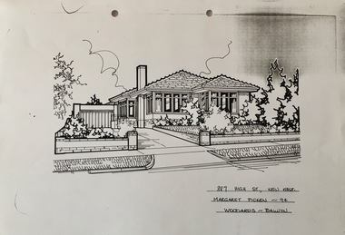
Drawing - Property Illustration, Margaret Picken, 887 High Street, Kew East, 1994
... 887 High Street, Kew East...property illustrations — buildings — kew east (vic.)...887 high street...Copy on paper of a pen and ink drawing of 887 High Street, Kew East by Margaret Picken....High Street Kew melbourne This drawing is one of a series created by Margaret Picken for real estate agents in Melbourne between 1983 and 2006. Each work is signed and dated by the artist. The drawings in the Picken Collection are invaluable assets for identifying architectural features and styles. The year in which the work was created is also a valuable record for house historians, as a number of the properties depicted have either been altered since that date or demolished. artist -- margaret picken 1950- property illustrations — buildings — kew east (vic.) 887 high street -- kew east (vic.) 887 HIGH ST., KEW EAST / MARGARET PICKEN ~94 / WOODARDS ~ BALWYN Copy on paper of a pen and ink drawing of 887 High Street, Kew East by Margaret Picken. 887 High Street, Kew East Drawing Property Illustration Margaret Picken Woodards (Balwyn) ...After training as a Cartographic Draftsman within the mining industry, I worked as a property illustrator for real estate firms in the eastern suburbs of Melbourne for 23 years from 1983. I initially photographed houses with a Polaroid camera and made a 'thumbnail' sketch while there. The photos were used to scale off a sketch in pencil and then that sketch was overlaid with drafting film and the 'pen and ink' completed. The pens I used were the Rotring ‘Rapidigraph’ drafting pens. The ink was also made by Rotring (German).The film was ‘Rapidraw’, polyester drafting film, double matte. It takes a very fine line and doesn’t bleed. As well as house sketches, there were often floor plans and site plans ordered. Aerial sketches were ordered when the property needed an overall view. (Margaret Picken, 2020)This drawing is one of a series created by Margaret Picken for real estate agents in Melbourne between 1983 and 2006. Each work is signed and dated by the artist.Gift of Margaret Picken, 2020Copy on paper of a pen and ink drawing of 887 High Street, Kew East by Margaret Picken.887 HIGH ST., KEW EAST / MARGARET PICKEN ~94 / WOODARDS ~ BALWYNartist -- margaret picken 1950-, property illustrations — buildings — kew east (vic.), 887 high street -- kew east (vic.) -
![EJ Harvey, Motor Engineers, High Street [Kew East], circa 1925](/media/collectors/550653872162f11fb04854aa/items/586f9929d0ce2607f0b81f1a/item-media/586f99e0d0ce2607f0b8546f/item-fit-380x285.jpg?cb=6) Kew Historical Society Inc
Kew Historical Society IncPhotograph - Photograph [copy], EJ Harvey, Motor Engineers, High Street [Kew East], circa 1925, c. 1925
... EJ Harvey, Motor Engineers, High Street [Kew East], circa 1925...The building was in High Street, Kew East between Clyde and Oswin Streets. ...Harvey, Motor Engineers workshop, High Street, East Kew. The garage was on the corner of Clyde Street....Inscription reverse: "High Street, East Kew - present site of Harvey Phillips Retro Vision[*] shop. ...Kew Historical Society Inc Kew Court House 188 High Street Kew melbourne The building was in High Street, Kew East between Clyde and Oswin Streets. ...The building was in High Street, Kew East between Clyde and Oswin Streets. The site is currently (2017) occupied by a canoe retailer.Rare and historic photograph of an early business in the Harp Village shopping precinctGarage - E.J. Harvey, Motor Engineers workshop, High Street, East Kew. The garage was on the corner of Clyde Street.Inscription reverse: "High Street, East Kew - present site of Harvey Phillips Retro Vision[*] shop. Gift of Edna Phillips. Edna loaned KHS the original photo and KHS had it copied." * Note - Harvey Phillips Retravision not Retro Vision].motor engineers (kew), garages (kew), e.j. harvey -
 Kew Historical Society Inc
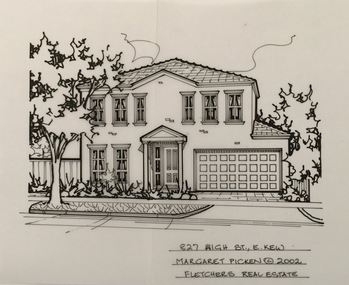
Drawing - Property Illustration, Margaret Picken, 827 High Street, Kew East, 2002
... 827 High Street, Kew East......827 high street - kew east (vic)....Pen and ink architectural drawing on drafting film of 827 High Street, East Kew by Margaret Picken....High Street Kew melbourne This drawing is one of a series created by Margaret Picken for a number of real estate agents in Melbourne between 1983 and 2005. Each work is signed and dated by the artist. The series of drawings in the Picken Collection are invaluable assets for identifying architectural features and styles. The year in which the drawing was created is also a valuable record for house historians, as a number of the properties depicted have either been altered since that date or demolished. artist -- margaret picken 1950- architectural drawings -- houses -- kew (vic.) 827 high street - kew east (vic). 827 HIGH ST., E.KEW / MARGARET PICKEN © 2002 / FLETCHERS REAL ESTATE Pen and ink architectural drawing on drafting film of 827 High Street, East Kew by Margaret Picken. 827 High Street, Kew East Drawing Property Illustration Margaret Picken Fletchers Real Estate ...After training as a Cartographic Draftsman within the mining industry, I worked as a property illustrator for real estate firms in the eastern suburbs of Melbourne for 23 years from 1983. I initially photographed houses with a Polaroid camera and made a 'thumbnail' sketch while there. The photos were used to scale off a sketch in pencil and then that sketch was overlaid with drafting film and the 'pen and ink' completed. The pens I used were the Rotring ‘Rapidigraph’ drafting pens. The ink was also made by Rotring (German).The film was ‘Rapidraw’, polyester drafting film, double matte. It takes a very fine line and doesn’t bleed. As well as house sketches, there were often floor plans and site plans ordered. Aerial sketches were ordered when the property needed an overall view. (Margaret Picken, 2020)This drawing is one of a series created by Margaret Picken for a number of real estate agents in Melbourne between 1983 and 2005. Each work is signed and dated by the artist.Gift of Margaret Picken, 2020Pen and ink architectural drawing on drafting film of 827 High Street, East Kew by Margaret Picken.827 HIGH ST., E.KEW / MARGARET PICKEN © 2002 / FLETCHERS REAL ESTATEartist -- margaret picken 1950-, architectural drawings -- houses -- kew (vic.), 827 high street - kew east (vic). -
 Kew Historical Society Inc
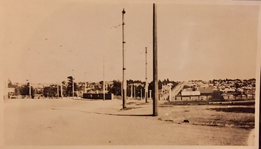
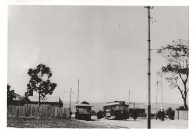
Slide - High Street, Kew East, 1980
... High Street, Kew East...high street -- kew east (vic.)...Slide High Street, Kew East ...One of a group of slides taken by members of the Society of built heritage in Kew in 1979-80. The selection of subject matter reflects the priorities of the period. The colour of some slides has degraded.The slides represent a snapshot in time of built architecture in Kew, much of which has changed in the forty-plus period since they were created. 35mm colour transparency (slide) of the Kew East shopping centre looking west in 1980.high street -- kew east (vic.), shopping centre -- kew east (vic.), commerce -- kew east (vic.) -
 Kew Historical Society Inc
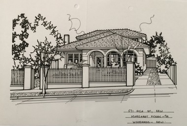
Drawing - Property Illustration, Margaret Picken, 571 High Street, Kew East, 1994
... 571 High Street, Kew East......571 high street - kew east (vic)....High Street Kew melbourne This drawing is one of a series created by Margaret Picken for a number of real estate agents in Melbourne between 1983 and 2005. Each work is signed and dated by the artist. The series of drawings in the Picken Collection are invaluable assets for identifying architectural features and styles. The year in which the drawing was created is also a valuable record for house historians, as a number of the properties depicted have either been altered since that date or demolished. artist -- margaret picken 1950- architectural drawings -- houses -- kew (vic.) 571 high street - kew east (vic). 571 HIGH ST., KEW / MARGARET PICKEN ~94 / WOODARDS ~ KEW Pen and ink drawing on drafting film of 571 High Street, Kew by Margaret Picken. 571 High Street, Kew East Drawing Property Illustration Margaret Picken Woodards (Kew) ...After training as a Cartographic Draftsman within the mining industry, I worked as a property illustrator for real estate firms in the eastern suburbs of Melbourne for 23 years from 1983. I initially photographed houses with a Polaroid camera and made a 'thumbnail' sketch while there. The photos were used to scale off a sketch in pencil and then that sketch was overlaid with drafting film and the 'pen and ink' completed. The pens I used were the Rotring ‘Rapidigraph’ drafting pens. The ink was also made by Rotring (German).The film was ‘Rapidraw’, polyester drafting film, double matte. It takes a very fine line and doesn’t bleed. As well as house sketches, there were often floor plans and site plans ordered. Aerial sketches were ordered when the property needed an overall view. (Margaret Picken, 2020)This drawing is one of a series created by Margaret Picken for a number of real estate agents in Melbourne between 1983 and 2005. Each work is signed and dated by the artist.Gift of Margaret Picken, 2020Pen and ink drawing on drafting film of 571 High Street, Kew by Margaret Picken.571 HIGH ST., KEW / MARGARET PICKEN ~94 / WOODARDS ~ KEWartist -- margaret picken 1950-, architectural drawings -- houses -- kew (vic.), 571 high street - kew east (vic). -
 Kew Historical Society Inc
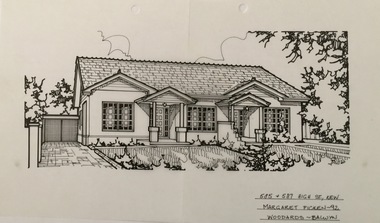
Drawing - Property Illustration, Margaret Picken, 585 & 587 High Street, Kew East, 1992
... 585 & 587 High Street, Kew East...585 & 587 high street - kew east (vic)....High Street Kew melbourne This drawing is one of a series created by Margaret Picken for a number of real estate agents in Melbourne between 1983 and 2005. Each work is signed and dated by the artist. The series of drawings in the Picken Collection are invaluable assets for identifying architectural features and styles. The year in which the drawing was created is also a valuable record for house historians, as a number of the properties depicted have either been altered since that date or demolished. artist -- margaret picken 1950- architectural drawings -- houses -- kew (vic.) 585 & 587 high street - kew east (vic). 585 + 587 HIGG ST., KEW / MARGARET PICKEN ~92 / WOODARDS ~ BALWYN Pen and ink architectural drawing on drafting film of 585 & 587 High Street, Kew by Margaret Picken. 585 & 587 High Street, Kew East Drawing Property Illustration Margaret Picken Woodards (Balwyn) ...After training as a Cartographic Draftsman within the mining industry, I worked as a property illustrator for real estate firms in the eastern suburbs of Melbourne for 23 years from 1983. I initially photographed houses with a Polaroid camera and made a 'thumbnail' sketch while there. The photos were used to scale off a sketch in pencil and then that sketch was overlaid with drafting film and the 'pen and ink' completed. The pens I used were the Rotring ‘Rapidigraph’ drafting pens. The ink was also made by Rotring (German).The film was ‘Rapidraw’, polyester drafting film, double matte. It takes a very fine line and doesn’t bleed. As well as house sketches, there were often floor plans and site plans ordered. Aerial sketches were ordered when the property needed an overall view. (Margaret Picken, 2020)This drawing is one of a series created by Margaret Picken for a number of real estate agents in Melbourne between 1983 and 2005. Each work is signed and dated by the artist.Gift of Margaret Picken, 2020Pen and ink architectural drawing on drafting film of 585 & 587 High Street, Kew by Margaret Picken.585 + 587 HIGG ST., KEW / MARGARET PICKEN ~92 / WOODARDS ~ BALWYNartist -- margaret picken 1950-, architectural drawings -- houses -- kew (vic.), 585 & 587 high street - kew east (vic). -
 Kew Historical Society Inc
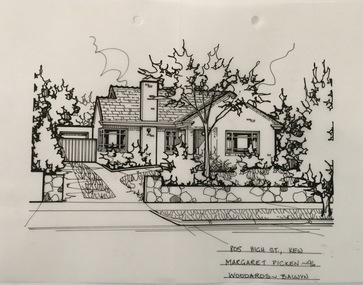
Drawing - Property Illustration, Margaret Picken, 805 High Street, Kew East, 1996
... 805 High Street, Kew East......805 high street - kew east (vic)...High Street Kew melbourne This drawing is one of a series created by Margaret Picken for a number of real estate agents in Melbourne between 1983 and 2005. Each work is signed and dated by the artist. The series of drawings in the Picken Collection are invaluable assets for identifying architectural features and styles. The year in which the drawing was created is also a valuable record for house historians, as a number of the properties depicted have either been altered since that date or demolished. artist -- margaret picken 1950- architectural drawings -- houses -- kew (vic.) 805 high street - kew east (vic) 805 HIGH ST., KEW / MARGARET PICKEN ~96 / WOODARDS ~ BALWYN Pen and ink architectural drawing on drafting film of 805 High Street, Kew by Margaret Picken. 805 High Street, Kew East Drawing Property Illustration Margaret Picken Woodards (Balwyn) ...After training as a Cartographic Draftsman within the mining industry, I worked as a property illustrator for real estate firms in the eastern suburbs of Melbourne for 23 years from 1983. I initially photographed houses with a Polaroid camera and made a 'thumbnail' sketch while there. The photos were used to scale off a sketch in pencil and then that sketch was overlaid with drafting film and the 'pen and ink' completed. The pens I used were the Rotring ‘Rapidigraph’ drafting pens. The ink was also made by Rotring (German).The film was ‘Rapidraw’, polyester drafting film, double matte. It takes a very fine line and doesn’t bleed. As well as house sketches, there were often floor plans and site plans ordered. Aerial sketches were ordered when the property needed an overall view. (Margaret Picken, 2020)This drawing is one of a series created by Margaret Picken for a number of real estate agents in Melbourne between 1983 and 2005. Each work is signed and dated by the artist.Gift of Margaret Picken, 2020Pen and ink architectural drawing on drafting film of 805 High Street, Kew by Margaret Picken.805 HIGH ST., KEW / MARGARET PICKEN ~96 / WOODARDS ~ BALWYNartist -- margaret picken 1950-, architectural drawings -- houses -- kew (vic.), 805 high street - kew east (vic) -
 Kew Historical Society Inc
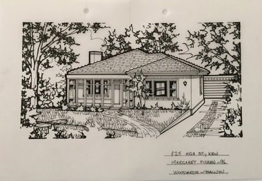
Drawing - Property Illustration, Margaret Picken, 825 High Street, Kew East, 1996
... 825 High Street, Kew East......825 high street - kew east (vic)....High Street Kew melbourne This drawing is one of a series created by Margaret Picken for a number of real estate agents in Melbourne between 1983 and 2005. Each work is signed and dated by the artist. The series of drawings in the Picken Collection are invaluable assets for identifying architectural features and styles. The year in which the drawing was created is also a valuable record for house historians, as a number of the properties depicted have either been altered since that date or demolished. artist -- margaret picken 1950- architectural drawings -- houses -- kew (vic.) 825 high street - kew east (vic). 825 HIGH ST., KEW / MARGARET PICKEN ~96 / WOODARDS ~ BALWYN Pen and ink architectural drawing on drafting film of 825 High Street, Kew by Margaret Picken. 825 High Street, Kew East Drawing Property Illustration Margaret Picken Woodards (Balwyn) ...After training as a Cartographic Draftsman within the mining industry, I worked as a property illustrator for real estate firms in the eastern suburbs of Melbourne for 23 years from 1983. I initially photographed houses with a Polaroid camera and made a 'thumbnail' sketch while there. The photos were used to scale off a sketch in pencil and then that sketch was overlaid with drafting film and the 'pen and ink' completed. The pens I used were the Rotring ‘Rapidigraph’ drafting pens. The ink was also made by Rotring (German).The film was ‘Rapidraw’, polyester drafting film, double matte. It takes a very fine line and doesn’t bleed. As well as house sketches, there were often floor plans and site plans ordered. Aerial sketches were ordered when the property needed an overall view. (Margaret Picken, 2020)This drawing is one of a series created by Margaret Picken for a number of real estate agents in Melbourne between 1983 and 2005. Each work is signed and dated by the artist.Gift of Margaret Picken, 2020Pen and ink architectural drawing on drafting film of 825 High Street, Kew by Margaret Picken.825 HIGH ST., KEW / MARGARET PICKEN ~96 / WOODARDS ~ BALWYNartist -- margaret picken 1950-, architectural drawings -- houses -- kew (vic.), 825 high street - kew east (vic). -
 Kew Historical Society Inc
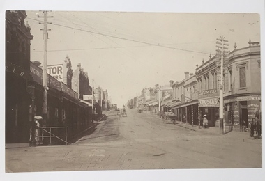
Postcard - High Street, East Kew, c.1927
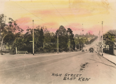
... High Street, East Kew...High Street, Kew is the main Road in Kew. It was once also known as Bulleen Road, or Main Street. This section of the road is in Kew, although the narrow section on the right hand side of the photo is now Kew East. ...Small, colorised real photo postcard of High Street, East Kew. Electric light poles line the road. ...Kew. Electric light poles line the road. Victoria Park is on the left and further on the horizon is the Boroondara General Cemetery. Postcard High Street, East ...High Street, Kew is the main Road in Kew. It was once also known as Bulleen Road, or Main Street. This section of the road is in Kew, although the narrow section on the right hand side of the photo is now Kew East. High Street progresses through a number of significant road junctions: beginning at Barkers Road; progressing through the intersection of Studley Park Road, Denmark Street and Princess Street at Kew Junction; branching left at the junction with Cotham Road; before reaching the junction with Valerie Street and Harp Road. It reaches its end at the junction of Burke Road, Kilby Road, Bulleen Road and High Street itself. An early photograph of this iconic Memorial that locates it in its context. Small, colorised real photo postcard of High Street, East Kew. Electric light poles line the road. Victoria Park is on the left and further on the horizon is the Boroondara General Cemetery.high street -- kew (vic.), victoria park, tram lines -- kew (vic.) -
 Kew Historical Society Inc
Photograph, Mavis Mackinnon, 1930s
... kew (vic)...miss tozer - milliner - high street - east kew (vic)...Mavis Mackinnon was a Kew resident who worked as dressmaker in business with Miss Tozer, a Milliner of High Street, East Kew, c1930-c.1939....Digital copy of a studio portrait of Mavis Mackinnon, dressmaker in business with Miss Tozer, Milliner of High Street, East Kew, c1930-c.1939....Kew Historical Society Inc Kew Court House 188 High Street Kew melbourne Mavis Mackinnon was a Kew resident who worked as dressmaker in business with Miss Tozer, a Milliner of High Street, East Kew, c1930-c.1939. mavis mackinnon dressmakers - kew (vic) miss tozer - milliner - high street - east kew (vic) Digital copy of a studio portrait of Mavis Mackinnon, dressmaker in business with Miss Tozer, Milliner of High Street, East Kew, c1930-c.1939. ...Mavis Mackinnon was a Kew resident who worked as dressmaker in business with Miss Tozer, a Milliner of High Street, East Kew, c1930-c.1939.Digital copy of a studio portrait of Mavis Mackinnon, dressmaker in business with Miss Tozer, Milliner of High Street, East Kew, c1930-c.1939.mavis mackinnon, dressmakers - kew (vic), miss tozer - milliner - high street - east kew (vic) -
![High Street, East Kew [looking west], 1977](/media/collectors/550653872162f11fb04854aa/items/586f8bbfd0ce0e07f06d22ed/item-media/586f8c3ad0ce0e07f06d44cc/item-fit-380x285.jpg?cb=6) Kew Historical Society Inc
Kew Historical Society IncPhotograph, High Street, East Kew, 1977
... High Street, East Kew..., looking approximately west toward Cemetery, October 1977. High Street, East Kew Photograph Photograph ...The Kew Historical Society's Pictures Collection is comprised of photographs and original works of art. The photographs include original (mainly) images dating from the 1870s to the present. A number of these photographs derive from the former City of Kew's Civic Collection while others are the work of amateur and professional photographers. Most of the images in the collection depict people, places and objects within the suburbs of Kew and Kew East. Other photographs depict other locations in Melbourne and Victoria. A number of the photographs are of statewide and/or national significance.View from junction of High and Strathalbyn Sts., Kew East, looking approximately west toward Cemetery, October 1977. Inscription reverse: "KH-72. View from junction of High St. & Strathalbyn Sts, Kew E. Looking approx. west, towards Cemetery. October 1977."high street -- kew (vic.), streetscapes -- kew (vic.) -
 Kew Historical Society Inc
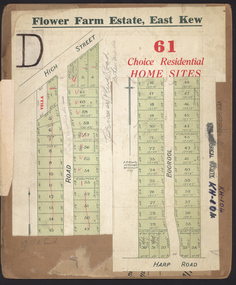
Plan - Subdivision Plan, Flower Farm Estate, East Kew, 1922
... east kew...flower farm estate...High Street...Kew East occurred in 1922. It included 61 lots on either side of Boorool Road between High Street and Harp Road. ...Kew. The Plans in the collection are rarely in pristine form, being working plans on which the agent would write notes and record lots sold and the prices of these. The subdivision plans are historically significant examples of the growth of urban Melbourne from the beginning of the 20th Century up until the 1980s. A number of the plans are double-sided and often include a photograph on the reverse. subdivision plans - east kew flower farm estate High Street ...Pru Sanderson, in her groundbreaking ‘City of Kew Urban Conservation Study : Volume 2 - Development History’ (1988), summarised the periods of urban development and subdivisions of land in Kew. The periods that she identified included 1845-1880, 1880-1893, 1893-1921, 1921-1933, 1933-1943, and Post-War Development. These periods were selected as they represented periods of rapid growth or decline in urban development. An obvious starting point for Sanderson’s groupings involved population growth and the associated economic cycles. These cycles also highlighted urban expansion onto land that was predominantly rural, although in other cases it represented the decline and breakup of large estates. A number of the plans in the Kew Historical Society’s collection can also be found in other collections, such as those of the State Library of Victoria and the Boroondara Library Service. A number are however unique to the collection.The Kew Historical Society collection includes almost 100 subdivision plans pertaining to suburbs of the City of Melbourne. Most of these are of Kew, Kew East or Studley Park, although a smaller number are plans of Camberwell, Deepdene, Balwyn and Hawthorn. It is believed that the majority of the plans were gifted to the Society by persons connected with the real estate firm - J. R. Mathers and McMillan, 136 Cotham Road, Kew. The Plans in the collection are rarely in pristine form, being working plans on which the agent would write notes and record lots sold and the prices of these. The subdivision plans are historically significant examples of the growth of urban Melbourne from the beginning of the 20th Century up until the 1980s. A number of the plans are double-sided and often include a photograph on the reverse. The subdivision called the ‘Flower Farm Estate’ in Kew East occurred in 1922. It included 61 lots on either side of Boorool Road between High Street and Harp Road. In an advertisement in The Argus in the same year, the proximity of the estate to the newly erected shops at the corner of Harp Road and High Street is noted. The Flower Farm Estate and similar subdivisions in Kew East were assisted by the extension of the High Street tramline in 1924.subdivision plans - east kew, flower farm estate, high street - kew east (vic.), boorool road -- kew east (vic.), harp road -- kew east (vic.) -
 Kew Historical Society Inc
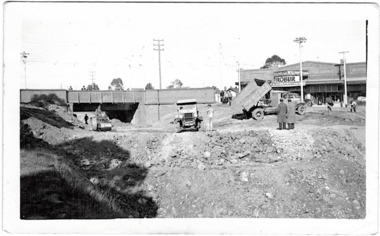
Photograph - Filling in the Outer Circle Railway cutting at East Kew, 1939
... ...high street -- kew east...East Kew. In the background is the metal bridge with brick piers, adjacent to the Harp Junction. The bridge crossed the cutting, linking the two parts of High Street. ... working on a significant piece of urban infrastructure. outer circle railway railway cuttings harp junction high street -- kew east Annotation in pencil on verso: "Filling in Outer Circle line at High St East Kew prior to straightening High St. ...W.D. Vaughan (Kew's Civic Century, 1960, pp.195-6) quotes Council Minutes of 1938 and 1939 to record that: "After protracted negotiations between the Council, the Railways Department and the Tramways Board agreement was reached in June, 1938, for the filling of the railway cutting at the Harp Junction and shifting tram tracks to the High Street alignment ... The Outer Circle railway land from Princess Street to Park Crescent was purchased by the Kew Council in October, 1939, for 2,750 [pounds]. The land from Park Crescent to High Street was leased for 1 [pound] per annum. Considerable work was done in levelling the embankments to the original surface level."Important and rare photograph of the period, showing major works by Kew Council in Kew East working on a significant piece of urban infrastructure.Small, original black and white positive (photograph) showing workers and vehicles filling in the tracks of the former Outer Circle railway at East Kew. In the background is the metal bridge with brick piers, adjacent to the Harp Junction. The bridge crossed the cutting, linking the two parts of High Street. Behind the tip truck, painted on the side with the name 'Fowler Quarries' [located Keilor Road, North Essendon], one can see shops [including T.G. Garroway, Cash Grocer] in High Street. What appears to be the City of Kew Steamroller is immediately in front of the bridge. A group of passers-by watch from the bridge and from the road. Annotation in pencil on verso: "Filling in Outer Circle line at High St East Kew prior to straightening High St. (c. Feb 1930?)outer circle railway, railway cuttings, harp junction, high street -- kew east -
 Kew Historical Society Inc
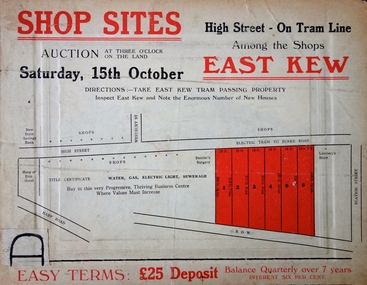
Plan - Subdivision Plan, Shop Sites, East Kew, c.1927
... east kew...high street - east kew...The subdivision proposed to create six shop sites in High Street between the Harp of Erin and Station Street. The plan shows this stretch of High Street, East Kew already lined with shops that include the hotel on the corner, the new State Savings Bank, a dentist’s surgery and Lambert’s Store. ...kew This is one of a small number of subdivision plans for commercial property in the collection. The subdivision proposed to create six shop sites in High Street between the Harp of Erin and Station Street. The plan shows this stretch of High Street, East ...Subdivision plans are historically important documents used as evidence of the growth of suburbs in Australia. They frequently provide information about when the land was sold on which a built structure was subsequently constructed as well as evidence relating to surveyors and real estate and financial agents. The numerous subdivision plans in the Kew Historical Society's collection represent working documents, ranging from the initial sketches made in planning a subdivision to printed plans on which auctioneers or agents listed the prices for which individual lots were sold. In a number of cases, the reverse of a subdivision plan in the collection includes a photograph of a house that was also for sale by the agent. These photographs provide significant heritage information relating house design and decoration, fencing and household gardens.This is one of a small number of subdivision plans for commercial property in the collection. The subdivision proposed to create six shop sites in High Street between the Harp of Erin and Station Street. The plan shows this stretch of High Street, East Kew already lined with shops that include the hotel on the corner, the new State Savings Bank, a dentist’s surgery and Lambert’s Store. The High Street Tram was to reach Burke Road in 1925, so the proposed subdivision must postdate that event, and the opening of the Bank in 1926.subdivision plans - east kew, high street - east kew -
 Kew Historical Society Inc
Photograph, Stewart West, Kew Junction Looking West along High Street, 1995
... High Street, Kew, looking east from Kew Junction. c. 1995...Kew Historical Society Inc Kew Court House 188 High Street Kew melbourne Photo created for a display about Kew comparing old (19th) and new (20th century) photographs Provides a picture of High Street Kew in the decade following the second widening of High Street in the 1950s. high street (kew) kew junction stewart west High Street, Kew, looking east from Kew Junction. c. 1995 Kew Junction Looking West along High Street Photograph Photograph Stewart West ...Photo created for a display about Kew comparing old (19th) and new (20th century) photographsProvides a picture of High Street Kew in the decade following the second widening of High Street in the 1950s.High Street, Kew, looking east from Kew Junction. c. 1995high street (kew), kew junction, stewart west -
 Kew Historical Society Inc
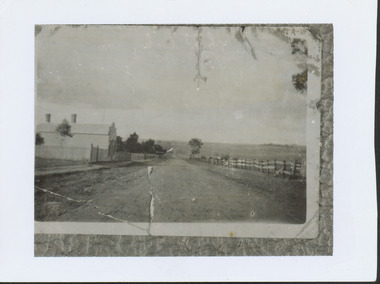
Photograph - High Street looking north to Burke Road, 1907-08
... ...High Street -- East Kew (Vic)...A rare image of the open farmland in the eastern part of Kew looking towards Burke Road in 1907-8. Harp of Erin High Street -- East Kew (Vic) harp estate HIGH ST LOOKING NOTRTH TO BURKE RD FROM HARP / EDWD GLYNN'S LOT 91 FROM 1851 / GIFT FROM BENNETT FAMILY 22 HARP RD EAST KEW 1980 / 1907-8 Damaged, and very rare, black & white photograph of what was to become the suburb of East Kew, taken by a member of the Bennett family in 1907-8. ...While a number of subdivisions of what was to become Kew East occurred in the 1880s, such as the 'Mount Pleasant Estate' (1888) and 'Monterey Estate' (1888), Glynn's Lot 91 remained open farmland until the Harp Estate (1912) was sold, hence the undeveloped nature of the view in 1907-8.A rare image of the open farmland in the eastern part of Kew looking towards Burke Road in 1907-8.Damaged, and very rare, black & white photograph of what was to become the suburb of East Kew, taken by a member of the Bennett family in 1907-8. The photograph is taken from the Harp of Erin Hotel showing, apart from a building on the left (no longer extant), fenced open farmland stretching into the far distance.HIGH ST LOOKING NOTRTH TO BURKE RD FROM HARP / EDWD GLYNN'S LOT 91 FROM 1851 / GIFT FROM BENNETT FAMILY 22 HARP RD EAST KEW 1980 / 1907-8harp of erin, high street -- east kew (vic), harp estate -
 Kew Historical Society Inc
Map - Map of Kew and Hawthorn Districts
... RW Perry / Real Estate & Insurance Agent, 602 High Street, East Kew...Kew (Vic.) RW Perry / Real Estate & Insurance Agent, 602 High Street, East Kew Two-colour map of Kew and Hawthorn Districts produced for by R.L. ...Map of Kew, East Kew and Hawthorn produced for a Kew Real Estate Agent, RW Perry. The map is undated.Two-colour map of Kew and Hawthorn Districts produced for by R.L. Jarrett for RW Perry, Real Estate & Insurance Agent. The map has unusual features such as a planned railway link from Kew Station to the former Outer Circle Railway. RW Perry / Real Estate & Insurance Agent, 602 High Street, East Kewmaps - kew (vic), maps - hawthorn (vic), r.w. perry, real estate agents -- kew (vic.) -
 Kew Historical Society Inc
Photograph, High Street, Kew, 1891
... Early photograph of High Street, Kew, looking east from Kew Junction....Kew Historical Society Inc Kew Court House 188 High Street Kew melbourne Early photograph of High Street, Kew, looking east from Kew Junction. high street, kew kew junction streets -- kew (Vic) High Street, Kew, circa 1891. ...Early photograph of High Street, Kew, looking east from Kew Junction.High Street, Kew, circa 1891.high street, kew, kew junction, streets -- kew (vic) -
 Melbourne Tram Museum
Photograph - High St Kew - Harp of Erin - PMTT, Les Poole, 1916
... Photograph shows a PMTT four-wheel Californian combination tram at the High Street East Kew terminus just northeast of Strathalbyn Street and Harp Road. ...Photograph shows a PMTT four-wheel Californian combination tram at the High Street East Kew terminus just northeast of Strathalbyn Street and Harp Road. ...Photograph shows a PMTT four-wheel Californian combination tram at the High Street East Kew terminus just northeast of Strathalbyn Street and Harp Road. The Harp of Erin Hotel fence and tree are on the right. There are few other buildings in the view. The Kew Cemetery line was extended along High Street to Strathalbyn Street, Kew on 8/5/1915. There is a tramway shelter on the left-hand side of the road. This photo is not taken at Burke Road. Yields information about the High Street Kew tram line c1916.Black and white photograph with a stamp and details on the rear.Has the stamp of the ARHS Vic Div L G Poole Collection and in ink "Harp of Erin 1916 - Hotel Burke Rd."trams, tramways, kew, high st kew, pmtt, shelters, harp of erin -
 Bendigo Historical Society Inc.
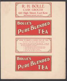
Document - CAMBRIDGE PRESS COLLECTION: LABEL - BOLLE'S PURE BLENDED TEA
... Bolle, Cash Grocer, 641 High Street, East Kew. This package contains 1/2 Lb. ...Street Bendigo goldfields BUSINESS Printers cambridge press Cambridge Press Collection R H Bolle Bolle's Pure Blended Tea Sheet with the four side labels for a packet of tea. Two are the same. Bolle's Pure Blended Tea in white with a gold outline on a red background and gold border. The third one has How to Make a Good Cup of Tea printed in red on a white background with a gold border and a flower in each corner. It is inside a double red border. The fourth has R. H. Bolle, Cash Grocer, 641 High Street, East Kew ...Sheet with the four side labels for a packet of tea. Two are the same. Bolle's Pure Blended Tea in white with a gold outline on a red background and gold border. The third one has How to Make a Good Cup of Tea printed in red on a white background with a gold border and a flower in each corner. It is inside a double red border. The fourth has R. H. Bolle, Cash Grocer, 641 High Street, East Kew. This package contains 1/2 Lb. Net. Has the same printing and border as the third one.business, printers, cambridge press, cambridge press collection, r h bolle, bolle's pure blended tea -
 Kew Historical Society Inc
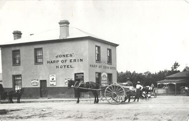
Photograph, Harp of Erin Hotel, c.1880
... Strategically situated on Bulleen Road (High Street) in East Kew, the ‘Harp of Erin’ was built on the corner of Harp Road and High Street. ...Kew Historical Society. harp of erin hotel dorothy rogers "Harp of Erin Hotel. Has been altered several times. First built by Edw. Glynn 1851. Not the first which was built in 1854." Harp of Erin (c.1864-1956). Strategically situated on Bulleen Road (High Street) in East ...This work forms part of the collection assembled by the historian Dorothy Rogers, that was donated to the Kew Historical Society by her son John Rogers in 2015. The manuscripts, photographs, maps, and documents were sourced by her from both family and local collections or produced as references for her print publications. Many were directly used by Rogers in writing ‘Lovely Old Homes of Kew’ (1961) and 'A History of Kew' (1973), or the numerous articles on local history that she produced for suburban newspapers. Most of the photographs in the collection include detailed annotations in her hand. The Rogers Collection provides a comprehensive insight into the working habits of a historian in the 1960s and 1970s. Together it forms the largest privately-donated collection within the archives of the Kew Historical Society.Harp of Erin (c.1864-1956). Strategically situated on Bulleen Road (High Street) in East Kew, the ‘Harp of Erin’ was built on the corner of Harp Road and High Street. The present hotel is the third to be built on the site. A second, two storey brick and stucco hotel built c.1864 replaced an earlier wooden structure built in 1854 by Edward Glynn. The ‘Harp’ was a local landmark, used by the Melbourne Hunt Club for their meetings. The Club had their kennels behind the hotel, and at meets, red-coated riders might be seen assembling from all directions. The later building was constructed in 1956."Harp of Erin Hotel. Has been altered several times. First built by Edw. Glynn 1851. Not the first which was built in 1854."harp of erin hotel, dorothy rogers -
 Kew Historical Society Inc
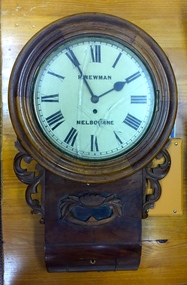
Functional object, H Newman, Boxed Wall Clock, 19th Century
... Roy Cronin 156 High Street Kew Jeweller and watchmaker. East side between Denmark Street and Cotham Road. ...Roy Cronin 156 High Street Kew Jeweller and watchmaker. East side between Denmark Street and Cotham Road. roy cronin - watchmaker - jeweller - kew (vic) h newman - melbourne (vic) - collins street - jeweller - clockmaker Wood, enamel, brass and glass wall clock, the movement made by H Newman of Collins Street, Melbourne. ...DEATH OF MR. H. NEWMAN. Widespread regret will be felt at the announcement of the death of Mr Henry Newman, an old colonist and a member of firm of Newman and Sons Proprietary Limited, jewellers, which occurred at his residence, "Sadova," William street, on Saturday, at the age of 89 years. Mr Newman who was born at Riga, in Russia, went to England when a lad, became naturalised, and emigrated to Victoria 61 years ago. He tried his fortune at Ballarat but soon afterwards returned to Melbourne, and began business as a jeweller, on a site in Collins street that is now occupied by Scott's Hotel. A few years later Mr Newman went back to England, where he was married. On his return to Victoria again he resumed his jewellery business in Elizabeth street opposite the General Post-office. An interesting fact in connection with his business is that his first journeyman watchmaker was Mr. Thomas Gaunt, the founder of the firm of Messrs. T. Gaunt & Co. Five years ago Mr. Newman retired from the business, which has since been carried on by his two elder sons. Although he took no active part in public affairs, Mr Newman was held in high regard on account of his business integrity, sterling personal worth. and the unostentatious way in which he did good. His vitality, even in his later years, was wonderful. On four occasions he met with accidents, having been twice knocked down by motorcars and twice by trams, without having sustained injury. A widow and grown up family of four sons and four daughters survive him. The Age Monday 27 October 1913, page 9. Roy Cronin 156 High Street Kew Jeweller and watchmaker. East side between Denmark Street and Cotham Road. Wood, enamel, brass and glass wall clock, the movement made by H Newman of Collins Street, Melbourne. A small label on the interior records the name R. Cronin, 156 High St, Kew, 1/7/20. It is unclear whether Cronin, a watchmaker and jeweller may have repaired or sold the clock. The clock (broken) is housed in a steel box.roy cronin - watchmaker - jeweller - kew (vic), h newman - melbourne (vic) - collins street - jeweller - clockmaker -
 Ballarat Tramway Museum
Slide - 35mm slide/s - set of 7, Noel Simons, 23/10/1965 12:00:00 AM
... High St. Kew" 1179.2 - "SW2 436 in Cotham Rd., Kew, about to enter High St." 1179.3 - "W2 545 in High Street Kew, nearly opposite Cotham Road" 1179.4 - "W2 648 entering High Street from High Street South, Kew". 1179.5 - "W2 566 entering High St. South from High St. Kew" 1179.6 - "W2 572 entering Victoria Pde from Brunswick St. East...High St Kew Cotham Road Victoria Parade Melbourne tram 545 tram 488 tram 436 tram 648 tram 566 tram 572 tram 378 All have date stamp of "23 Oct 1965" in purple ink. All black ink unless otherwise noted. 1179.1 - "W2 488 Entering Cotham Rd. from High St. Kew" 1179.2 - "SW2 436 in Cotham Rd., Kew, about to enter High St." 1179.3 - "W2 545 in High Street Kew, nearly opposite Cotham Road" 1179.4 - "W2 648 entering High Street from High Street South, Kew". 1179.5 - "W2 566 entering High St. South from High St. Kew" 1179.6 - "W2 572 entering Victoria Pde from Brunswick St. East ...Set of 7 Kodachrome transparencies taken on 23/10/1965 in Melbourne. 1179.1 - W2 488 (route 42, Mont Albert) at the corner of High St. and Cotham Road Kew. Taken from Kew Post Office, has Bank of New South Wales in the background, CBC bank and the Greyhound Hotel. Tram has ads for Kolotex stockings and Ryco oil filters. 1179.2 - SW2 436, in bound (route 45, City) leaving Cotham Road, about to join High St, Kew. Buildings on the south side of Cotham Road in photo. Tram has an ad along with others for Vincent's powders. 1179.3 - W2 545 (route 48, North Balwyn) in High St. Kew. Has Commercial bank in background along with other shops. 1179.4 - W2 648 (route 42, Mont Albert) turning from High St. South into High St at Kew Junction, with Clifton Hotel in background. Tram has an ad for Kenric clothes. Note an MFBB street fire alarm by the tram stop. 1179.5 - W2 566 (inbound route 42, City) at same location as 1179.5. Tram has a Jex and a Remy Martin Brandy ads. on front dash panel. 1179.6 - W2 572 entering Victoria Parade from Brunswick St. Fitzroy. Tram has a Jex and a Remy Martin Brandy ads. on front dash panel. Eastern Hill Fire Station and ICI building in background. 1179.7 - W2 378 (inbound, route 45, City) and W2 572, inbound, in Victoria Parade between Brunswick St and Gismo St. East Melbourne. Otherwise as for 1179.6.All have date stamp of "23 Oct 1965" in purple ink. All black ink unless otherwise noted. 1179.1 - "W2 488 Entering Cotham Rd. from High St. Kew" 1179.2 - "SW2 436 in Cotham Rd., Kew, about to enter High St." 1179.3 - "W2 545 in High Street Kew, nearly opposite Cotham Road" 1179.4 - "W2 648 entering High Street from High Street South, Kew". 1179.5 - "W2 566 entering High St. South from High St. Kew" 1179.6 - "W2 572 entering Victoria Pde from Brunswick St. East Melbourne" 1179.7 - "W2 378 and 572 in Victoria Pde between Brunswick and Gisborne Sts. East Melbourne."tramways, trams, kew, high st kew, cotham road, victoria parade, melbourne, tram 545, tram 488, tram 436, tram 648, tram 566, tram 572, tram 378 -
 Uniting Church Archives - Synod of Victoria
Photograph, Rev. Ron Albiston, Undated c.1940s
... High School, the Victorian Congregational College and the University of Melbourne. From a young age he held positions within the local church, was secretary of the East Kew Congregational Church at the age of 16, as well as superintendent of the Sunday School from the age of 15. Ron was supported during his life and ministry by his wife of 63 years, Dorothy. He was ordained at Northcote Congregational Church on 21 December 1942. His ministry was exercised in Northcote/Clifton Hill (1942–45), Yarrawonga and associated district (1945–50), Ballarat Dawson Street...Street Malvern East melbourne The Rev. Ronald W Albiston 28/9/1919–16/08/2006 was educated at Melbourne Boys' High School, the Victorian Congregational College and the University of Melbourne. From a young age he held positions within the local church, was secretary of the East Kew ...The Rev. Ronald W Albiston 28/9/1919–16/08/2006 was educated at Melbourne Boys' High School, the Victorian Congregational College and the University of Melbourne. From a young age he held positions within the local church, was secretary of the East Kew Congregational Church at the age of 16, as well as superintendent of the Sunday School from the age of 15. Ron was supported during his life and ministry by his wife of 63 years, Dorothy. He was ordained at Northcote Congregational Church on 21 December 1942. His ministry was exercised in Northcote/Clifton Hill (1942–45), Yarrawonga and associated district (1945–50), Ballarat Dawson Street and "Zion" Sebastopol (1950–68), and Rockdale Congregational, Sydney, later Uniting (1968–83). Due to ill health, Ron retired on the 30th of April 1983. He was President of the Australian Council of Churches from 1971 to 1973, President of the Congregational Union of NSW from 1973 to 1975. As a member of the Joint Planning Committee he was involved in the development of the Uniting Church and inaugural Chairperson. Following union, he was a member and later Chairman of the Board of Social Responsibility. He was instrumental in founding the Mayflower Village for the Aged, the Rockdale Community Aid Service, and helped form the St George Community Conference.The Rev. Ronald W Albiston 28/9/1919–16/08/2006 was educated at Melbourne Boys' High School, the Victorian Congregational College and the University of Melbourne. From a young age he held positions within the local church, was secretary of the East Kew Congregational Church at the age of 16, as well as superintendent of the Sunday School from the age of 15. Ron was supported during his life and ministry by his wife of 63 years, Dorothy. He was ordained at Northcote Congregational Church on 21 December 1942. His ministry was exercised in Northcote/Clifton Hill (1942–45), Yarrawonga and associated district (1945–50), Ballarat Dawson Street and "Zion" Sebastopol (1950–68), and Rockdale Congregational, Sydney, later Uniting (1968–83). Due to ill health, Ron retired on the 30th of April 1983. He was President of the Australian Council of Churches from 1971 to 1973, President of the Congregational Union of NSW from 1973 to 1975. As a member of the Joint Planning Committee he was involved in the development of the Uniting Church and inaugural Chairperson. Following union, he was a member and later Chairman of the Board of Social Responsibility. He was instrumental in founding the Mayflower Village for the Aged, the Rockdale Community Aid Service, and helped form the St George Community Conference.The Rev. Ronald W Albiston 28/9/1919–16/08/2006 was educated at Melbourne Boys' High School, the Victorian Congregational College and the University of Melbourne. From a young age he held positions within the local church, was secretary of the East Kew Congregational Church at the age of 16, as well as superintendent of the Sunday School from the age of 15. Ron was supported during his life and ministry by his wife of 63 years, Dorothy. He was ordained at Northcote Congregational Church on 21 December 1942. His ministry was exercised in Northcote/Clifton Hill (1942–45), Yarrawonga and associated district (1945–50), Ballarat Dawson Street and "Zion" Sebastopol (1950–68), and Rockdale Congregational, Sydney, later Uniting (1968–83). Due to ill health, Ron retired on the 30th of April 1983. He was President of the Australian Council of Churches from 1971 to 1973, President of the Congregational Union of NSW from 1973 to 1975. As a member of the Joint Planning Committee he was involved in the development of the Uniting Church and inaugural Chairperson. Following union, he was a member and later Chairman of the Board of Social Responsibility. He was instrumental in founding the Mayflower Village for the Aged, the Rockdale Community Aid Service, and helped form the St George Community Conference.Informal B & W photo of the Rev. Ron Albiston. Albiston is standing, hands clasped behind back, smiling into the camera. He's dressed in a suit with clerical collar and waistcoat. The photo has been taken outdoors, possibly at a picnic."Rev. Ron Albiston"albiston, ron, congregational minister -
 Kew Historical Society Inc
Photograph - Victorian Villa, High Street, c.1922
... High Street. It occupied part of Lot 91, bought by Edward Glyn in the land sale of 16th October 1851, and run as a flower farm’. The subdivision called the ‘Flower Farm Estate’ in East Kew occurred in 1922. ...high street - kew (vic.) violet farm estate subdivisions - kew (vic.) Photographer's name on photograph, lower right, and stamp on mount lower right: "A. Aberline, Glenferrie". An old inscription on this photograph identifies it as ‘an elegant timber villa in High Street. It occupied part of Lot 91, bought by Edward Glyn in the land sale of 16th October 1851, and run as a flower farm’. The subdivision called the ‘Flower Farm Estate’ in East ...Subdivision plans are historically important documents used as evidence of the growth of suburbs in Australia. They frequently provide information about when the land was sold on which a built structure was subsequently constructed as well as evidence relating to surveyors and real estate and financial agents. The numerous subdivision plans in the Kew Historical Society's collection represent working documents, ranging from the initial sketches made in planning a subdivision to printed plans on which auctioneers or agents listed the prices for which individual lots were sold. In a number of cases, the reverse of a subdivision plan in the collection includes a photograph of a house that was also for sale by the agent. These photographs provide significant heritage information relating house design and decoration, fencing and household gardens.An old inscription on this photograph identifies it as ‘an elegant timber villa in High Street. It occupied part of Lot 91, bought by Edward Glyn in the land sale of 16th October 1851, and run as a flower farm’. The subdivision called the ‘Flower Farm Estate’ in East Kew occurred in 1922. [The subdivision plan is on the reverse of this photo.] The Estate included 61 lots on either side of Boorool Road between High Street and Harp Road. In the MMBW Detail Plan 2017 of 1926, a number of these new villas had already been built. Matching houses with MMBW maps can always be a challenge, however if this house was near the corner of Boorool Road and High Street, it seems to fit the profile of a house called ‘Maxton’ (demolished).Photographer's name on photograph, lower right, and stamp on mount lower right: "A. Aberline, Glenferrie".houses - maxton - high street - kew (vic.), violet farm estate, subdivisions - kew (vic.) -
 Kew Historical Society Inc
Plan - Subdivision Plan, Jas R Mathers Son & McMillan, Eastlawn Estate : East Kew Auction Sale, 1914
... High, Station and Wright Streets, Harp and Normanby Roads, and Woodlands Avenue. Pru Sanderson in the Kew Conservation Study (Vol.2, 1988) wrote that the Eastlawn Estate ‘covered the western half of the failed Harp of Erin Estate’. Contemporary advertisements promoted the Eastlawn Estate as: ‘There will be no more convenient district nor pleasant Suburb than East...High, Station and Wright Streets, Harp and Normanby Roads, and Woodlands Avenue. Pru Sanderson in the Kew Conservation Study (Vol.2, 1988) wrote that the Eastlawn Estate ‘covered the western half of the failed Harp of Erin Estate’. Contemporary advertisements promoted the Eastlawn Estate as: ‘There will be no more convenient district nor pleasant Suburb than East ...The Kew Historical Society's map collection includes a substantial number of real estate subdivision plans, mainly of Kew but also of surrounding suburbs in Melbourne. Most of the subdivision plans date from the 1920s and 1930s when the districts old homes and local farmland were being split up to accommodate residential growth in the postwar period. These early plans were assembled by a local firm, Jas R Mather & McMillan, which had an office in Cotham Road. Many of the plans, and sometimes photos, were annotated by the agents.Subdivision plans are historically important documents used as evidence for the growth of suburbs in Australia. They frequently provide information about when the land was sold as well as evidence relating to surveyors and real estate and financial agents. The numerous subdivision plans in the Kew Historical Society's collection represent working documents, ranging from the initial sketches made in planning a subdivision to printed plans on which auctioneers or agents listed the prices for which individual lots were sold. In a number of cases, the reverse of a subdivision plan in the collection includes a photograph of a house that was also for sale by the agent. These photographs provide significant heritage information relating house design and decoration, fencing and household gardens.The photograph may also be aesthetically significant depending on the importance of the photographic atelier.The ‘Eastlawn Estate’ was surveyed and ready for auction in March 1914, three months before the outbreak of World War I. Sixty-six allotments, created on the ‘order of Mr & Miss Preston’ surrounded the mansion of Woodlands in Harp Road. Woodlands formed part of the Estate, being advertised as lot 1. The allotments faced High, Station and Wright Streets, Harp and Normanby Roads, and Woodlands Avenue. Pru Sanderson in the Kew Conservation Study (Vol.2, 1988) wrote that the Eastlawn Estate ‘covered the western half of the failed Harp of Erin Estate’. Contemporary advertisements promoted the Eastlawn Estate as: ‘There will be no more convenient district nor pleasant Suburb than East Kew for the busy business man. When the Electric Tram is laid, he will be able to journey quickly and pleasantly direct from Collins Street to his home in the Eastlawn Estate in about 20 minutes’. The actual plans of subdivision were included in advertisements in The Argus and in the local newspapers."C" top left. Various annotations.subdivision plans - kew, station street, normanby road, high street, woodlands avenue, harp road, woodlands - kew -
 Kew Historical Society Inc
Furniture - Toolbox constructed from recycled materials
... High Street Kew melbourne Toolbox, made by Salvation Army Brigadier Warren Trestrail (1895-1971), during the Great Depression from recycled kerosene tins and packing boxes. It proved to be a useful piece of furniture as the family moved around Australia during various postings within the Australian States and Territories. In World War II, Warren Trestrail embarked with the first convoy of soldiers from Australia to the Middle East ...Toolbox, made by Salvation Army Brigadier Warren Trestrail (1895-1971), during the Great Depression from recycled kerosene tins and packing boxes. It proved to be a useful piece of furniture as the family moved around Australia during various postings within the Australian States and Territories. In World War II, Warren Trestrail embarked with the first convoy of soldiers from Australia to the Middle East and served as Salvation Army welfare officer through the Libyan campaign, at Tobruk, and in Greece. In 1942, it was announced that Salvation Army war services at Darwin would be placed under his direction. He had previously been in charge of South Australian war activities. The item was donated to the Society in 2001 by Sadie Trestrail, who had been a teacher at Kew East Primary School for many years. It is a fine example of vernacular furniture made of recycled materials .Depression-era toolbox constructed from recycled kerosene tins and parts of wooden packing boxes. The five tin drawers are made of sections of kerosene tins with handles soldered to the centre of each new drawer. A number of drawers have separators constructed of tin or aluminium. The wooden planks encasing the the drawers are covered with a degraded shellac coating. An analysis of the interior indicates that the brand names of the original parts are largely extant. furniture - recycled - depession era - 1930s, great depression - 1930s - australia, warren trestrail, salvation army, vernacular furniture -
 Kew Historical Society Inc
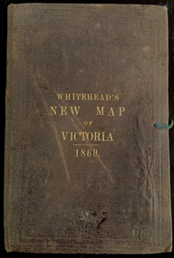
Map, Whitehead's Map of Victoria, With Alphabetical Key, 1869, 1869
... High Street Kew melbourne When E. Whitehead's New Map of Victoria was released in 1869, an advertisement in the Bendigo Advertiser (16 July 1869) noted that: "This beautifully engraved Map has been revised and brought down to the present time; and, with the Alphabetical Key, is the most complete and the cheapest Map ever published; Price, 6d plain; 1s colored; 2s 6d in case; on linen, post free, 2d extra. E.. WHITEHEAD and CO, Publishers, 67 Collins-street east ...When E. Whitehead's New Map of Victoria was released in 1869, an advertisement in the Bendigo Advertiser (16 July 1869) noted that: "This beautifully engraved Map has been revised and brought down to the present time; and, with the Alphabetical Key, is the most complete and the cheapest Map ever published; Price, 6d plain; 1s colored; 2s 6d in case; on linen, post free, 2d extra. E.. WHITEHEAD and CO, Publishers, 67 Collins-street east." The following year, 1870, Whitehead's promoted the edition in the Portland Guardian and Normanby General Advertiser (3 January 1870), advising that: "WHITEHEAD'S NEW MAP OF VICTORIA, 1869 ... is corrected to the latest date, and around is arranged an Alphabetical Key, with Post Towns and Money Order Olffices marked. The Map being divided into squares and numbered, by reference to the Key any place can be found immediately. Price Is beautifully colored, or mounted on linen in case, 2s 6d. Post free, 2d extra, in Victoria. B. Whitehead and C0., Puolishers, 67 Collins-street East, Melbourne". In the same edition of the Portland Advertiser, they also promoted their business generally, saying: "E WHITEHEAD and Co., Stationers, Engravers, Lithographers, 67 Collins street East, execute every description of Lithographic PRINTING, BILL-HEADS. NOTE Headings. Business Dies Engraved and Embossed on Envelopes &c. ARMS, MONOGRAMS, AND CRESTS Engraved and Embossed in Colour, superior to any other house in the Colony. Specimens, post free, 2d. Lithographers, &c, to H.R.H. the Duke of Edinburgh, and Die-inkers and Embossers to His Excellency Sir J. H. T. Manners-Sutton, K C.B. Orders executed for the Trade". Whitehead’s New Map of Victoria 1869 is is an important record of region created towards the end of the Victorian Gold Rush (1851-1869). In addition to its historical significance, this is a rare map, of which the only known copies in Australian public collections are those held at the National Library of Australia, the State Library of Victoria, State Library of New South Wales and the University of Queensland Library.Map of Victoria with gold mining areas, notes on topography, transport routes. Relief shown by hachures. List of towns with distance from Melbourne in map margin. [Melbourne] : Printed & Published by ... E Whitehead & Co ... 67 Collins Street East, 1869 1 map : col., mounted on linen ; 38.4 x 55.4 cm, folded to 18 x 12 cm.Cover "WHITEHEAD'S NEW MAP OF VICTORIA 1869"maps - victoria - 1860s, e whitehead's new map of victoria 1869, whitehead's map of victoria with alphabetical key 1869, cartography, gold rush