Showing 902 items matching "high street south"
-
 Kew Historical Society Inc
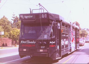
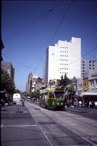
Photograph - A Class 237 in High Street South, 1990
... A Class 237 in High Street South...Laminated colour enlargement of an A Class tram No.237 in High Street South taken at a re-enactment from the Kew Depot in 1990....A Class 237 in High Street South"...Photograph A Class 237 in High Street South ...This colour photograph, with 15 others are enlargements gifted to the Society by Mel Lawrence in 2016. They were taken at a commemorative event from the Kew Tram Depot. Laminated colour enlargement of an A Class tram No.237 in High Street South taken at a re-enactment from the Kew Depot in 1990.Annotation reverse: "Kew Depot. A Class 237 in High Street South"kew tram depot, class a trams - melbourne -
 Kew Historical Society Inc
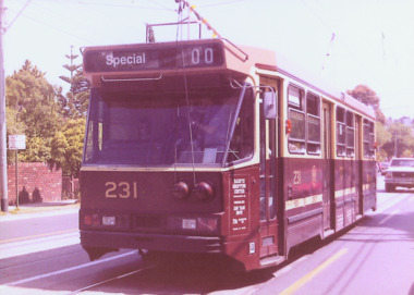
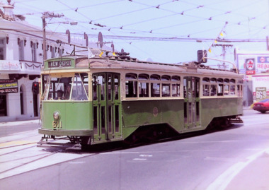
Photograph - A Class 231 in High Street South, 1990
... A Class 231 in High Street South...Laminated colour enlargement of A Class tram 231 in High Street South, during a re-enactment from the Kew Depot in 1990....A Class 231 in High Street South"...Photograph A Class 231 in High Street South ...This colour photograph, with 15 others are enlargements gifted to the Society by Mel Lawrence in 2016. They were taken at a commemorative event from the Kew Tram Depot. Laminated colour enlargement of A Class tram 231 in High Street South, during a re-enactment from the Kew Depot in 1990.Annotation reverse: "Kew Depot 1990. A Class 231 in High Street South"kew tram depot, trams -- melbourne, a class trams -
 Kew Historical Society Inc
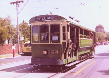
Photograph - S Class 164 in High Street South, 1990
... S Class 164 in High Street South...Laminated colour enlargement of an 'S Class' tram No 164 in High Street South, taken at a re-enactment at the Kew Depot in 1990....S Class 164 in High Street South."...Photograph S Class 164 in High Street South ...This colour photograph, with 15 others are enlargements gifted to the Society by Mel Lawrence in 2016. They were taken at a commemorative event at the Kew Tram Depot. Laminated colour enlargement of an 'S Class' tram No 164 in High Street South, taken at a re-enactment at the Kew Depot in 1990.Annotation reverse: "Kew Depot 1990. S Class 164 in High Street South."kew tram depot, s class trams -- melbourne -
 Kew Historical Society Inc
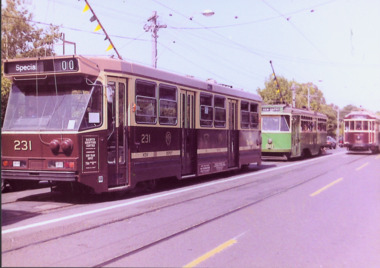
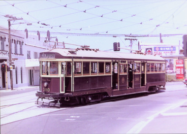
Photograph - A Class 231, Y1 Class B11 & W2 Class 380 in High Street South, 1990
... A Class 231, Y1 Class B11 & W2 Class 380 in High Street South...Laminated colour enlargement of trams in High Street South during a re-enactment from the Kew Depot in 1990....A Class 231, Y1 Class, B11 & W2 Class 380 in High Street South"...Photograph A Class 231, Y1 Class B11 & W2 Class 380 in High Street South ...This colour photograph, with 15 others are enlargements gifted to the Society by Mel Lawrence in 2016. They were taken at a commemorative event from the Kew Tram Depot. Laminated colour enlargement of trams in High Street South during a re-enactment from the Kew Depot in 1990.Annotation reverse: "Kew Depot 1990. A Class 231, Y1 Class, B11 & W2 Class 380 in High Street South"kew tram depot, a class trams, trams -- melbourne, y1 class trams, w2 class trams -
 Kew Historical Society Inc
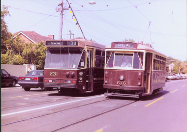
Photograph - Class A 231 & X2 Class 676 in High Street South, 1990
... Class A 231 & X2 Class 676 in High Street South...Laminated colour enlargement of a Class A 231 & X2 Class 676 in High Street South taken at a re-enactment from the Kew Depot in 1990....Class A 231 & X2 Class 676 in High Street South"...Photograph Class A 231 & X2 Class 676 in High Street South ...This colour photograph, with 15 others are enlargements gifted to the Society by Mel Lawrence in 2016. They were taken at a commemorative event from the Kew Tram Depot. Laminated colour enlargement of a Class A 231 & X2 Class 676 in High Street South taken at a re-enactment from the Kew Depot in 1990.Annotation reverse: "Kew Depot 1990. Class A 231 & X2 Class 676 in High Street South"kew tram depot, class a trams - melbourne, x2 class trams - melbourne -
 Kew Historical Society Inc
Photograph - W Class 380 turning out of Barkers Road into High Street South, 1990
... W Class 380 turning out of Barkers Road into High Street South...Laminated colour enlargement of W Class tram No.380 turning out of Barkers Road into High Street South, during a re-enactment in 1990....W Class 380 turning out of Barkers Road into High Street South"...Photograph W Class 380 turning out of Barkers Road into High Street South ...This colour photograph, with 15 others are enlargements gifted to the Society by Mel Lawrence in 2016. They were taken at a commemorative event from the Kew Tram Depot. Laminated colour enlargement of W Class tram No.380 turning out of Barkers Road into High Street South, during a re-enactment in 1990.Annotation reverse: "Kew Depot 1990. W Class 380 turning out of Barkers Road into High Street South"kew tram depot, trams -- melbourne, a class trams -
 Kew Historical Society Inc
Photograph - Y1 Class 611 in Barkers Road and High Street South, 1990
... Y1 Class 611 in Barkers Road and High Street South...Laminated colour enlargement of Y1 Class 611, on the corner of Barkers Road and High Street South, during a re-enactment from the Kew Depot in 1990....Y1 Class 611, turning out of Barkers Road into High Street South"...Photograph Y1 Class 611 in Barkers Road and High Street South ...This colour photograph, with 15 others are enlargements gifted to the Society by Mel Lawrence in 2016. They were taken at a commemorative event from the Kew Tram Depot. Laminated colour enlargement of Y1 Class 611, on the corner of Barkers Road and High Street South, during a re-enactment from the Kew Depot in 1990.Annotation reverse: "Kew Depot 1990. Y1 Class 611, turning out of Barkers Road into High Street South"kew tram depot, trams -- melbourne, y1 class trams -
 Kew Historical Society Inc
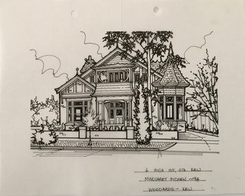
Drawing - Property Illustration, Margaret Picken, 6 High Street South, Kew, 1994
... 6 High Street South, Kew......6 high street south - kew (vic)....Pen and ink architectural drawing on drafting film of 6 High Street South, Kew by Margaret Picken....STH., KEW / MARGARET PICKEN ~94 / WOODARDS ~ KEW Pen and ink architectural drawing on drafting film of 6 High Street South, Kew by Margaret Picken. 6 High Street South, Kew Drawing Property Illustration Margaret Picken Woodards (Kew) ...After training as a Cartographic Draftsman within the mining industry, I worked as a property illustrator for real estate firms in the eastern suburbs of Melbourne for 23 years from 1983. I initially photographed houses with a Polaroid camera and made a 'thumbnail' sketch while there. The photos were used to scale off a sketch in pencil and then that sketch was overlaid with drafting film and the 'pen and ink' completed. The pens I used were the Rotring ‘Rapidigraph’ drafting pens. The ink was also made by Rotring (German).The film was ‘Rapidraw’, polyester drafting film, double matte. It takes a very fine line and doesn’t bleed. As well as house sketches, there were often floor plans and site plans ordered. Aerial sketches were ordered when the property needed an overall view. (Margaret Picken, 2020)This drawing is one of a series created by Margaret Picken for a number of real estate agents in Melbourne between 1983 and 2005. Each work is signed and dated by the artist.Gift of Margaret Picken, 2020Pen and ink architectural drawing on drafting film of 6 High Street South, Kew by Margaret Picken.6 HIGH ST. STH., KEW / MARGARET PICKEN ~94 / WOODARDS ~ KEWartist -- margaret picken 1950-, architectural drawings -- houses -- kew (vic.), 6 high street south - kew (vic). -
 Kew Historical Society Inc
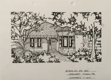
Drawing - Property Illustration, Margaret Picken, 24 High Street South, Kew, 1992
... 24 High Street South, Kew......24 high street south - kew (vic)....Pen and ink architectural drawing on drafting film of 24 High Street South, Kew by Margaret Picken....STH., KEW / MARGARET PICKEN ~92 / WOODARDS ~ KEW Pen and ink architectural drawing on drafting film of 24 High Street South, Kew by Margaret Picken. 24 High Street South, Kew Drawing Property Illustration Margaret Picken Woodards (Kew) ...After training as a Cartographic Draftsman within the mining industry, I worked as a property illustrator for real estate firms in the eastern suburbs of Melbourne for 23 years from 1983. I initially photographed houses with a Polaroid camera and made a 'thumbnail' sketch while there. The photos were used to scale off a sketch in pencil and then that sketch was overlaid with drafting film and the 'pen and ink' completed. The pens I used were the Rotring ‘Rapidigraph’ drafting pens. The ink was also made by Rotring (German).The film was ‘Rapidraw’, polyester drafting film, double matte. It takes a very fine line and doesn’t bleed. As well as house sketches, there were often floor plans and site plans ordered. Aerial sketches were ordered when the property needed an overall view. (Margaret Picken, 2020)This drawing is one of a series created by Margaret Picken for a number of real estate agents in Melbourne between 1983 and 2005. Each work is signed and dated by the artist.Gift of Margaret Picken, 2020Pen and ink architectural drawing on drafting film of 24 High Street South, Kew by Margaret Picken.24 HIGH ST. STH., KEW / MARGARET PICKEN ~92 / WOODARDS ~ KEWartist -- margaret picken 1950-, architectural drawings -- houses -- kew (vic.), 24 high street south - kew (vic). -
 Kew Historical Society Inc
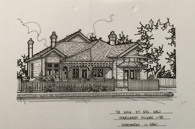
Drawing - Property Illustration, Margaret Picken, 74 High Street South, Kew, 1993
... 74 High Street South, Kew......74 high street south - kew (vic)....Pen and ink architectural drawing on drafting film of 74 High Street South, Kew by Margaret Picken....STH., KEW / MARGARET PICKEN ~93 / WOODARDS ~ KEW Pen and ink architectural drawing on drafting film of 74 High Street South, Kew by Margaret Picken. 74 High Street South, Kew Drawing Property Illustration Margaret Picken Woodards (Kew) ...After training as a Cartographic Draftsman within the mining industry, I worked as a property illustrator for real estate firms in the eastern suburbs of Melbourne for 23 years from 1983. I initially photographed houses with a Polaroid camera and made a 'thumbnail' sketch while there. The photos were used to scale off a sketch in pencil and then that sketch was overlaid with drafting film and the 'pen and ink' completed. The pens I used were the Rotring ‘Rapidigraph’ drafting pens. The ink was also made by Rotring (German).The film was ‘Rapidraw’, polyester drafting film, double matte. It takes a very fine line and doesn’t bleed. As well as house sketches, there were often floor plans and site plans ordered. Aerial sketches were ordered when the property needed an overall view. (Margaret Picken, 2020)This drawing is one of a series created by Margaret Picken for a number of real estate agents in Melbourne between 1983 and 2005. Each work is signed and dated by the artist.Gift of Margaret Picken, 2020Pen and ink architectural drawing on drafting film of 74 High Street South, Kew by Margaret Picken.74 HIGH ST. STH., KEW / MARGARET PICKEN ~93 / WOODARDS ~ KEWartist -- margaret picken 1950-, architectural drawings -- houses -- kew (vic.), 74 high street south - kew (vic). -
 Kew Historical Society Inc
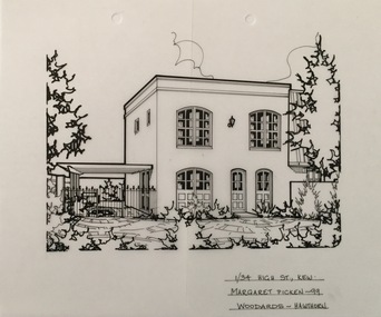
Drawing - Property Illustration, Margaret Picken, 1/34 High Street South, Kew, 1999
... 1/34 High Street South, Kew......1/34 high street south - kew (vic)....Pen and ink architectural drawing on drafting film of 1/34 High Street South, Kew by Margaret Picken....STH., KEW / MARGARET PICKEN ~99 / WOODARDS ~ HAWTHORN Pen and ink architectural drawing on drafting film of 1/34 High Street South, Kew by Margaret Picken. 1/34 High Street South, Kew Drawing Property Illustration Margaret Picken Woodards (Hawthorn) ...This drawing is one of a series created by Margaret Picken for a number of real estate agents in Melbourne between 1983 and 2005. Each work is signed and dated by the artist.Gift of Margaret Picken, 2020Pen and ink architectural drawing on drafting film of 1/34 High Street South, Kew by Margaret Picken.1/34 HIGH ST. STH., KEW / MARGARET PICKEN ~99 / WOODARDS ~ HAWTHORNartist -- margaret picken 1950-, architectural drawings -- houses -- kew (vic.), 1/34 high street south - kew (vic). -
 Wodonga & District Historical Society Inc
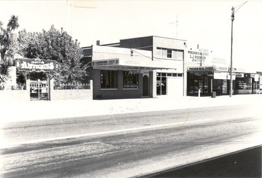
Photograph - Codling Collection 01 - High Street just south of South Street. Early to mid 1980's
... Codling Collection 01 - High Street just south of South Street. Early to mid 1980's....Codling Collection 01 - High Street just south of South Street. Early to mid 1980's....Buildings in High Street just south of the intersection with South Street, Wodonga. ...South Street. Early to mid 1980's. Photograph Codling Collection 01 - High Street just south of South Street. ...Miss Olive Codling was a Foundation Member and a Life Member of the Wodonga Historical Society. Many of her prize-winning photos are held in the Society Collection. She also held a range of roles and committee positions in a wide range of Wodonga community organisations. These included the Horticultural Society, the Wodonga Arts Council, the Wodonga Camera Club and the Wodonga Lapidary Club. This photo collection is significant as it documents how the businesses and buildings in Wodonga have evolved and contributed to community throughout the 20th century.Buildings in High Street just south of the intersection with South Street, Wodonga. Businesses including Chitty's Antiques, Hoover City Chinese Restaurant, Phegan Real Estate and Jay Dean Construction. Between Hoover City and Phegan's was Number 90 High Street. Harris Lieberman Solicitors was at that location in the mid 1970s. In 2021, a hairdresser operates out of the former Phegan's store and Hoover City is the location of Rock 'n' Roll Roasts. Chitty's Antiques occupied part of the former Bank of N.S.W. premises. It later became The Secret Cup coffee shop which has since closed.wodonga businesses, high st wodonga, chitty antiques, phegan real estate, hoover city chinese restaurant -
 Kew Historical Society Inc
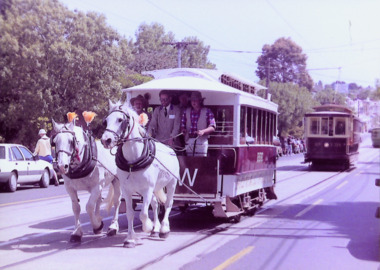
Photograph - Horse Tram in High Street South, 1990
... Horse Tram in High Street South...Laminated colour enlargement of a horse-drawn tram in High Street South after leaving the Kew Tram Depot in 1990. ...Photograph Horse Tram in High Street South ...The original route of the Kew Horse tram extended from Victoria Bridge to the Boroondara General (Kew) Cemetery. This colour photograph, with 15 others are enlargements gifted to the Society by Mel Lawrence in 2016. They were taken at a commemorative event at the Kew Tram Depot.Laminated colour enlargement of a horse-drawn tram in High Street South after leaving the Kew Tram Depot in 1990. The printed word 'Kew' was presumably added for the event. Annotation reverse: "Kew Depot 1990. Horse tram in High St. Sth followed by V Class 214"kew tram depot, kew horse tram -
 Kew Historical Society Inc
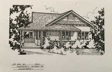
Drawing - Property Illustration, Margaret Picken, 50 High Street South, Kew, 1990
... 50 High Street South, Kew...Pen and ink architectural drawing on drafting film of 50 High Street South, Kew by Margaret Picken....The year in which the drawing was created is also a valuable record for house historians, as a number of the properties depicted have either been altered since that date or demolished. artist -- margaret picken 1950- architectural drawings -- houses -- kew (vic.) 50 high street - kew (vic). 50 HIGH ST., KEW / MARGARET PICKEN '90 / WOODARDS ~ Pen and ink architectural drawing on drafting film of 50 High Street South, Kew by Margaret Picken. 50 High Street South, Kew Drawing Property Illustration Margaret Picken Woodards ...After training as a Cartographic Draftsman within the mining industry, I worked as a property illustrator for real estate firms in the eastern suburbs of Melbourne for 23 years from 1983. I initially photographed houses with a Polaroid camera and made a 'thumbnail' sketch while there. The photos were used to scale off a sketch in pencil and then that sketch was overlaid with drafting film and the 'pen and ink' completed. The pens I used were the Rotring ‘Rapidigraph’ drafting pens. The ink was also made by Rotring (German).The film was ‘Rapidraw’, polyester drafting film, double matte. It takes a very fine line and doesn’t bleed. As well as house sketches, there were often floor plans and site plans ordered. Aerial sketches were ordered when the property needed an overall view. (Margaret Picken, 2020)This drawing is one of a series created by Margaret Picken for a number of real estate agents in Melbourne between 1983 and 2005. Each work is signed and dated by the artist.Gift of Margaret Picken, 2020Pen and ink architectural drawing on drafting film of 50 High Street South, Kew by Margaret Picken.50 HIGH ST., KEW / MARGARET PICKEN '90 / WOODARDS ~ artist -- margaret picken 1950-, architectural drawings -- houses -- kew (vic.), 50 high street - kew (vic). -
 Wodonga & District Historical Society Inc
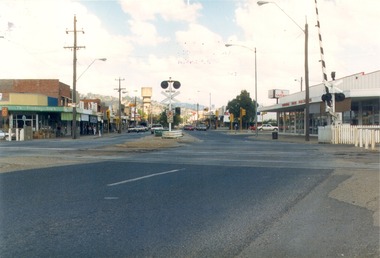
Photograph - Codling Collection 01 - High Street Wodonga looking south from the railway crossing, 1987
... Codling Collection 01 - High Street Wodonga looking south from the railway crossing...Codling Collection 01 - High Street Wodonga looking south from the railway crossing...High Street Wodonga looking south from the railway crossing. ...Codling Collection 01 - High Street Wodonga looking south from the railway crossing Photograph Codling Collection 01 - High Street Wodonga looking south from the railway crossing ...Miss Olive Codling was a Foundation Member and a Life Member of the Wodonga Historical Society. Many of her prize-winning photos are held in the Society Collection. She also held a range of roles and committee positions in a wide range of Wodonga community organisations. These included the Horticultural Society, the Wodonga Arts Council, the Wodonga Camera Club and the Wodonga Lapidary Club. This photo collection is significant as it documents how the businesses and buildings in Wodonga have evolved and contributed to community throughout the 20th century.High Street Wodonga looking south from the railway crossing. Railway boom gate and Wodonga Home Furnishers on the right. Safeway sign in the carpark in the background. The Water Tower is in the distance. The Finishing Touch is on the left. This photo was taken for Heritage Week 1987.wodonga businesses, high st wodonga, railway crossing -
 Wodonga & District Historical Society Inc
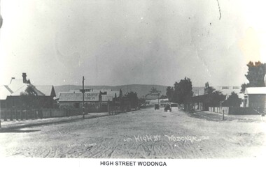
Photograph - High Street Wodonga, looking south, Thomas Bonsema, c1916
... High Street Wodonga, looking south...High Street Wodonga, looking south...This view of High Street looking south was taken from the Fire Tower which was on the north west corner of Elgin Street and High Street intersection. ...A black and white image of a section of High Street, Wodonga looking towards the south and hills in the background....High Street Wodonga, looking south Photograph High Street Wodonga, looking south Thomas Bonsema ...This view of High Street looking south was taken from the Fire Tower which was on the north west corner of Elgin Street and High Street intersection. The Shire Hall is in the front right. On the left are Dumbrell Timber merchant and Schlink & Son, General Storekeepers. After this is the area which would later be developed as Woodland Grove. The finger post in the front points to Barnawartha. Our Collection includes several photographs signed BONSEMA WODONGA or sometimes simply TBW. Thomas Peter John Bonsema was born in Wodonga in 1876 to Peter John Bonsema and Mary Ann nee Nash. His name first appears on the Electoral Roll for Wodonga in 1909 and on the Electoral Roll in 1912 he is listed as a photographer. His photographs capture many scenes and events around Wodonga and surrounding areas. Thomas Bonsema married Minna Louisa Jones in 1912. By 1914 he had moved to Chiltern, Victoria where he established Bonsema’s Photographic Studio. From this time onward many of his works bore the signature “BONSEMA CHILTERN”. As well as continuing to photograph landscapes and important buildings, Mr Bonsema was often the official photographer at school and community celebrations. He also sold many framed photographs and postcards from his premises at 68 -70 Conness Street, Chiltern. By 1943 Thomas John Bonsema had relocated to New South Wales and died in Beecroft, NSW on 14th July 1944. Some of his photographs are held in the Victorian State Library and Mitchell Library Sydney Collections.These images are significant because they are the work of a recognised photographer Thomas Bonsema who was born in Wodonga in 1876. A black and white image of a section of High Street, Wodonga looking towards the south and hills in the background.Across bottom of image - BONSEMA WODONGA - HIGH STREET WODONGAbonsema photography, thomas peter john bonsema, high street wodonga -
 Rutherglen Historical Society
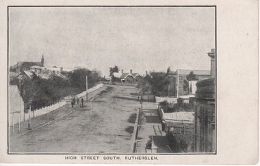
Image, High Street South, Rutherglen, c1890
... High Street South, Rutherglen...Black and white postcard photograph of High Street, Rutherglen, facing south....High Street South, Rutherglen Image ...At left of photo is the roof and spire of St Stephen's Church. The building that can be seen at the centre of the photo is the house now located between the police station and the former court house.Black and white postcard photograph of High Street, Rutherglen, facing south.high street -
 Melbourne Tram Museum
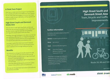
Pamphlet, Yarra Trams, "High Street South and Denmark St, Kew - tram, bicycle and traffic improvements", 2009
... "High Street South and Denmark St, Kew - tram, bicycle and traffic improvements"...Set of two pamphlets issued to advise passengers of tramway works and improvements during 2009. .1 - "High Street South and Denmark St, Kew - tram, bicycle and traffic improvements" - introduction of tram lanes and no right hand turns - April 2009 .2 - "Tram Improvement works Routes 48, 70, 109 and 112" - construction of curves from Wellington and Flinders St into Spring St and from Spring St into Collins St and other changes - May - July 2009...Melbourne Tram Museum 8 Wallen Road Hawthorn melbourne Trams tramways High St Kew Collins St Spring St City Circle Route 48 Route 70 Route 109 Route 112 Route 24 Construction Set of two pamphlets issued to advise passengers of tramway works and improvements during 2009. .1 - "High Street South and Denmark St, Kew - tram, bicycle and traffic improvements" - introduction of tram lanes and no right hand turns - April 2009 .2 - "Tram Improvement works Routes 48, 70, 109 and 112" - construction of curves from Wellington and Flinders St into Spring St and from Spring St into Collins St and other changes - May - July 2009 "High Street South and Denmark St, Kew - tram, bicycle and traffic improvements" Pamphlet Yarra Trams ...Set of two pamphlets issued to advise passengers of tramway works and improvements during 2009. .1 - "High Street South and Denmark St, Kew - tram, bicycle and traffic improvements" - introduction of tram lanes and no right hand turns - April 2009 .2 - "Tram Improvement works Routes 48, 70, 109 and 112" - construction of curves from Wellington and Flinders St into Spring St and from Spring St into Collins St and other changes - May - July 2009trams, tramways, high st kew, collins st, spring st, city circle, route 48, route 70, route 109, route 112, route 24, construction -
 Melbourne Tram Museum
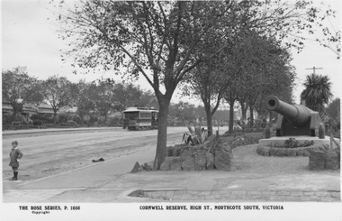
Postcard - Cornwell Reserve, High Street, Northcote South, Rose Stereograph Co, 1913-1920s
... Cornwell Reserve, High Street, Northcote South...Photograph looks north along High Street from corner of Urquhart Street with a Northcote line cable tram travelling northward. The large cannon is one of two located at southern end of High Street in June 1913 by the Northcote South Ratepayer’s Association. ...On front: 'The Rose Series P 1056 Cornwell Reserve, High Street, Northcote South'; on rear: 'Postcard - A real photograph Produced in Australia'...Yields information about High Street Northcote South Northcote cable tram Cornwell Reserve High Street Linear Reserve. ...Photograph looks north along High Street from corner of Urquhart Street with a Northcote line cable tram travelling northward. The large cannon is one of two located at southern end of High Street in June 1913 by the Northcote South Ratepayer’s Association. The cannons were originally built in England in 1884/8 5 and installed in Melbourne's South Channel Fort off Sorrento to defend against possible Russian invasion. Cornwell Reserve is now known as High Street Linear Reserve. Rose postcard 1056.Yields information about High Street Northcote South Postcard with label below photograph and postcard markings on rear. On front: 'The Rose Series P 1056 Cornwell Reserve, High Street, Northcote South'; on rear: 'Postcard - A real photograph Produced in Australia'northcote, cable tram, cornwell reserve, high street linear reserve., high st, urquhart st, rose series -
 Kew Historical Society Inc
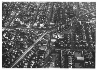
Photograph - Kew Junction, Herald & Weekly Times, 1962
... high street kew...studley park road...kew war memorial...kew post office...kew police station...kew court house...high street south...An aerial photograph of Kew Junction, showing the intersection of High Street South, Studley Park Road, Princess Street, High Street and Denmark Street. ...An aerial photograph of Kew Junction, showing the intersection of High Street South, Studley Park Road, Princess Street, High Street and Denmark Street. ...This is an aerial oblique image looking north. It shows Kew Junction before construction of VicRoads (Country Roads Board), Murphy's (Leo's) supermarket, and office towers. It also shows a building on the land now known as the Raoul Wallenberg Reserve, the Kew Municipal Offices in Walpole Street, and St Paul's School for the Blind in Fernhurst Grove, and Kew Bowling Club in Wellington Street.An aerial photograph of Kew Junction, showing the intersection of High Street South, Studley Park Road, Princess Street, High Street and Denmark Street. A number of buildings, now demolished can be identified in the photo, including Jellis’ Bakeries on the corner of Princess Street and Studley Park Road." Annotation on reverse: "Kew Historical Society from Mr L. H. Chinner".kew junction, aerial photograph (kew), oblique aerial, st paul's school for the blind, kew municipal offices, high street kew, studley park road, kew war memorial, kew post office, kew police station, kew court house, high street south, kew, wellington street kew, denmark street kew -
 Melbourne Tram Museum
Slide - MMTB, KCR, Yarra and MTA, tramway operations set of 12, Hugh Ballment, 1950s to 1990s
... ...High Street South...Set of 12 photos by Hugh Ballment, unless noted, of MMTB, KCR, MTA and Yarra trams: HBM127 - MTA Tram 2, cNov 1997, Swanston St, northbound, near Lonsdale Street HBM128 - MTA SW5 class tram No. 848, April 1988, High Street South, Kew, Near back road Kew depot HBM129 - MTA A Class trams No.235, 251, Apr 1988, High Street South, Kew at Barkers Road, shows the east exit track from the Kew Depot into High Street South. ...Melbourne Tram Museum 8 Wallen Road Hawthorn melbourne Set of 12 photos by Hugh Ballment, unless noted, of MMTB, KCR, MTA and Yarra trams: HBM127 - MTA Tram 2, cNov 1997, Swanston St, northbound, near Lonsdale Street HBM128 - MTA SW5 class tram No. 848, April 1988, High Street South, Kew, Near back road Kew depot HBM129 - MTA A Class trams No.235, 251, Apr 1988, High Street South, Kew at Barkers Road, shows the east exit track from the Kew Depot into High Street South. ...Set of 12 photos by Hugh Ballment, unless noted, of MMTB, KCR, MTA and Yarra trams: HBM127 - MTA Tram 2, cNov 1997, Swanston St, northbound, near Lonsdale Street HBM128 - MTA SW5 class tram No. 848, April 1988, High Street South, Kew, Near back road Kew depot HBM129 - MTA A Class trams No.235, 251, Apr 1988, High Street South, Kew at Barkers Road, shows the east exit track from the Kew Depot into High Street South. HBM130 - Yarra Tram 866, cNov 1997, Spencer St, City Circle livery, at Bourke St. In the background is the Spencer St station building. HBM131 - KCR, cNov1997, ComEng Dandenong, Tuen Mun tram, Hong Kong, in the water testing bay. With a Comeng train shell alongside. HBM132 - MTA Tram 2040, cNov1997, Spencer St, at Latrobe Street, with the Australia Post and the Remand Centre buildings in the background. Tram has an advertisment for Bertocchi. HBM133 - MTA Tram 2023, cNov1997, Bourke Street, at Elizabeth Street with London Stores, and Roger David in the background. HBM134 - MTA Tram 169, cNov1997, Queensbridge, running a route 55 Domain & St Kilda Road service. In the background are the National Mutual, Port Authority, and National Bank buildings. A Comeng train is on the viaduct HBM135 -, cNov 1997, East Camberwell, ComEng train HBM136 - MTA Tram 276, Apr 1988, Collins Street, At Spring Street, running a route 109 to Mont Albert. HBM137 - MTA B class tram No. 2002, and A class tram No. 284, c1997?, Clarendon Street, South Melbourne, running each Route 96 to St Kilda and Route 109 to Mont Albert, respectively. Has a large Crown Casino and Planet Hollywood signs in the background. HBM138 - MMTB Trams 934, 252, 1950s, Batman Ave, RAAF tram, leaving for Burwood route 74. Has a route 72. W2 class tram behind. Yields information about Melbourne tram operations, with 1950s to 1980s photos of Melbourne tramways.Kodachrome cardboard and plastic mounts, with notes - set of 12new tramway, elizabeth st, flinders st, kew depot, bourke st, swanston st, tram 2, tram 848, tram 235, tram 251, tram 866, spencer st, city circle, tram 2040, tram 2023, tram 169, hong kong, comeng, tram 286, tram 2002, tram 284, tram 934, tram 252, raaf, batman ave, clarendon st, a class, high street south, b class, w2 class, sw6 class -
 Ruyton Girls' School
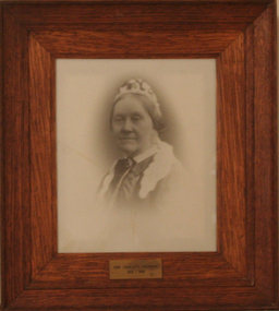
Photograph - Photographic Portrait, Mrs Charlotte Anderson
... ...High Street South...Mrs Anderson operated Ruyton initially in her own home of 63 Bulleen Road, Kew (now 63 High Street South). According to Ruyton histories, Mrs Anderson is said to have begun the school with her own two sons, four daughters and some of her Alsop nieces and nephews who resided in Kew. ...Mrs Anderson operated Ruyton initially in her own home of 63 Bulleen Road, Kew (now 63 High Street South). According to Ruyton histories, Mrs Anderson is said to have begun the school with her own two sons, four daughters and some of her Alsop nieces and nephews who resided in Kew. ...Mrs Charlotte Anderson was born Charlotte Eliza Alsop in England in 1838 and arrived in Australia in 1848. She married lawyer James Anderson in 1864, and in the year of his death in 1878 she became the founding owner-Principal of Ruyton Girls' School, Kew. Mrs Anderson operated Ruyton initially in her own home of 63 Bulleen Road, Kew (now 63 High Street South). According to Ruyton histories, Mrs Anderson is said to have begun the school with her own two sons, four daughters and some of her Alsop nieces and nephews who resided in Kew. Around the time of the addition of Maud King, the first student outside the family, the school changed to a 'Ladies College', and the boys were sent elsewhere for their education. By late 1881 Mrs Anderson began using the name 'Ruyton' for the school, in honour of a connection to Ruyton-XI-Towns, Shropshire, England where her great-grandfather had been vicar and where she was baptised. In 1882 Mrs Anderson moved the School to Edgecomb in Studley Park Road from 1882-1888. The larger premises enabled her to begin accepting boarding students from 1882. She retired due to ill health and sold the school to her friend Miss Eliza Bromby. Mrs Anderson lived at 'Bongamero', in the King Valley, Victoria until her death in 1906. She is buried in Boroondara Cemetery. One of Ruyton's four Houses, Anderson, is named for Charlotte Anderson. Artwork AC/0099 is a framed reproduction photograph of an original portrait of Mrs Anderson, c.1900-1906. The location and date of the original photograph is unknown, but may be held among Ruyton papers at the State Library of Victoria (MS 12079). The reproduction was probably created to be part of the gallery of Principals and significant people for the Conference/Boardroom, Henty House.A framed, black & white reproduction of a photographic portrait. The portrait shows the head and shoulders of a middle aged woman wearing Victorian-era clothing including a dark ribbon tied around her collar. She wears a lace cap on her head, and the cap's tail is draped around her shoulders. The woman's body is partially turned away from the camera, while her face is turned toward the camera. Plaque on frame: "Mrs Charlotte Anderson/ 1878-1888"charlotte anderson, ruyton, ruyton girls' school, kew (vic), bulleen road, high street south, studley park road, edgecomb, woman, school, teacher, principal, anderson, reproduction, 1990s -
 Kew Historical Society Inc
Archive (Sub-series) - Subject File, Kew Historical Society, FULLER, Alfred, 1958
... Archive file containing a one page article from Kewriosity (Dec 1985-Jan 1986) on Alfred Fuller, the brewer and organ builder who had his business in High Street South, next to the Clifton Hotel....High Street Kew melbourne Since its foundation in 1958, members of the Kew Historical Society have been compiling and storing information about subjects relating to the history of Kew and its environs, of which this file is an example. Typically files will contain primary and secondary sources. kew historical society - archives music - organs - kew (vic) manufacturing - kew (vic) alfred fuller breweries - kew (vic) Archive file containing a one page article from Kewriosity (Dec 1985-Jan 1986) on Alfred Fuller, the brewer and organ builder who had his business in High Street South, next to the Clifton Hotel. ...Various partiesReference, Research, InformationSecondary Values (KHS Imposed Order)Subject file containing a one page article from Kewriosity (Dec 1985-Jan 1986) on Alfred Fuller, the brewer and organ builder who had his business in High Street South, next to the Clifton Hotel.kew historical society - archives, music - organs - kew (vic), manufacturing - kew (vic), alfred fuller, breweries - kew (vic)kew historical society - archives, music - organs - kew (vic), manufacturing - kew (vic), alfred fuller, breweries - kew (vic) -
 Kew Historical Society Inc
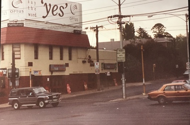
Photograph - Clifton Hotel, Kew Junction, 1994
... Fading colour positive photograph of the Clifton Hotel at Kew Junction on the corner of High Street South and Studley Park Road. The hotel had been modified extensively over time, disguising the original Italianate facade. ...Studley Park Road at Kew Junction. 1994 Fading colour positive photograph of the Clifton Hotel at Kew Junction on the corner of High Street South and Studley Park Road. The hotel had been modified extensively over time, disguising the original Italianate facade. ...Of the eight hotels established in Kew since European settlement, The Hotel Kew, known for most of its existence, as the Clifton Hotel was the seventh to be built in 1868. Its location on the corner of Studley Park Road and High Street at Kew Junction makes it a prominent landmark. Its current name is confusing for local historians as its main rival for the first 52 years was O'Shaughnessy's Hotel (1855), later renamed the Kew Hotel, on the corner of High Street and Denmark Street. Looking at the façade of the Hotel Kew, it is hard to imagine its mid-nineteenth appearance. There have probably been at least four renovations or rebuilding(s) of the structure. The documented renovations have occurred in the 1930s when the late Victorian façade was given an Art Deco update. In about 1970 its façade was again 'improved'. The many publicans who have held the licenses of the Clifton Hotel have been identified in in the 'Tetlow Index' and on the 'Boroondara Local History Wiki'. The most significant of these are Henry Madden (1880-87); Michael O'Donnell (1902-1920); and the Cronin-Ryan family (1935–53ff).Fading colour positive photograph of the Clifton Hotel at Kew Junction on the corner of High Street South and Studley Park Road. The hotel had been modified extensively over time, disguising the original Italianate facade. This is the colour scheme of the fourth restoration, including huge advertising billboards on the roof.Reverse: "Clifton Hotel. Studley Park Road at Kew Junction. 1994clifton hotel -- kew (vic.), hotels -- kew (vic.), kew junction -
Kew Historical Society Inc
Archive (Sub-series) - Subject File, Conservation Study (Kew) 1978, 1978
... The proposal to the Urban Renewal Authority relates to those houses in Denmark Street, High Street South and Barkers Road, then known as ‘The Triangle’ (historically known as O’Shaughnessy’s Paddock. ...High Street Kew melbourne Since its foundation in 1958, members of the Kew Historical Society have been compiling and storing information about subjects relating to the history of Kew and its environs, of which this file is an example. Typically files will contain primary and secondary sources. urban renewal -- kew (vic.) conservation studies -- kew (vic.) kew triangle association Archive file containing a copy of the City of Kew’s Urban Renewal Proposal (13pp), dated June 1978. The proposal to the Urban Renewal Authority relates to those houses in Denmark Street, High Street South ...Various partiesReference, Research, InformationSecondary Values (KHS Imposed Order)Subject file containing a copy of the City of Kew’s Urban Renewal Proposal (13pp), dated June 1978. The proposal to the Urban Renewal Authority relates to those houses in Denmark Street, High Street South and Barkers Road, then known as ‘The Triangle’ (historically known as O’Shaughnessy’s Paddock. The report refers to the Kew Triangle Association.urban renewal -- kew (vic.), conservation studies -- kew (vic.), kew triangle associationurban renewal -- kew (vic.), conservation studies -- kew (vic.), kew triangle association -
 Kew Historical Society Inc
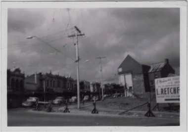
Photograph - Kew Junction during road widening, December 1958
... Kew Junction is the intersection of five major roads - Denmark Street, High Street, High Street South, Studley Park Road and Princess Street. ...Kew Historical Society Inc Kew Court House 188 High Street Kew melbourne Kew Junction is the intersection of five major roads - Denmark Street, High Street, High Street South, Studley Park Road and Princess Street. ...Kew Junction is the intersection of five major roads - Denmark Street, High Street, High Street South, Studley Park Road and Princess Street. The original widening of High Street in the 1930s expanded that street by removing shops on the south side of the street from Cotham Road to Denmark Street. Further widening in 1958 removed shops at the west end of High Street to allow for increased traffic using Princes Street and Denmark Street.Original, black and white positive of Kew Junction, including the corner with Denmark Street during road widening in the 1958.Inscribed verso: "Kew Junction Dec 1958 / When the road was being widened by the removal of a number of shops / Notice saying Retchford's Estate agency's temporary office is at the top end of Denmark Street, Kew"kew junction, denmark street -- kew (vic.), major roadworks -- kew (vic.) -
 Kew Historical Society Inc
Photograph - Denmark Street, Kew, 1972
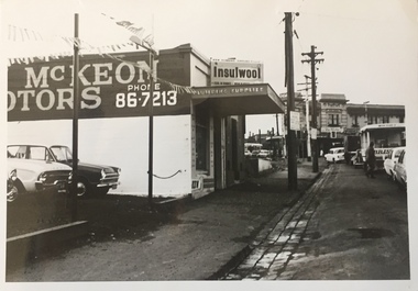
... High Street and Princess Street (later demolished during the widening of Kew Junction). Notable are the bluestone guttering and what appears to be vacant land on the apex of the triangle of land bounded by High Street South, Denmark Street and Barkers Road. ...High St prior to reconstruction of channeling &c 1972." Original black and white photographic positive of automobiles and buildings in Denmark Street, Kew, immediately before the road enters Kew Junction. On the left is McKeon Motors and a retailer of Insulwool, while in the distance is the pharmacy on the corner of High Street and Princess Street (later demolished during the widening of Kew Junction). Notable are the bluestone guttering and what appears to be vacant land on the apex of the triangle of land bounded by High Street South ...The Engineer's Department of the former City of Kew had an extensive collection of photograph of sites in Kew requiring documentation to inform public works. It also kept images of engineering practice in other parts of Melbourne, and overseas, that could be used as models for local activity. Many of these photographs (and plans) were donated to our collection in the 1980s. A number of the photographs are annotated, either on the image itself or on the reverse.This photograph, and others sourced from the City Engineer's Department of the former City of Kew, qualifies as an important record of local streets, public works, street beautification, and engineering techniques of the period. Original black and white photographic positive of automobiles and buildings in Denmark Street, Kew, immediately before the road enters Kew Junction. On the left is McKeon Motors and a retailer of Insulwool, while in the distance is the pharmacy on the corner of High Street and Princess Street (later demolished during the widening of Kew Junction). Notable are the bluestone guttering and what appears to be vacant land on the apex of the triangle of land bounded by High Street South, Denmark Street and Barkers Road. This site was the original location of O'Shaughnessy's 'Kew Hotel', and after the destruction by fire of the latter, the location of a service station. [It is now the site of the Cresco Reserve].Annotation verso: "Indicating the existence of a vehicular entrance at Denmark St abuttal of No.188 High St prior to reconstruction of channeling &c 1972."denmark street -- kew (vic.), kew junction, luestone gutters, mckeon motors, insulwool -
 Kew Historical Society Inc
Photograph, Stuart Tompkins Studio, Electricity Supply Poles, Warrigal Road, Ashwood, 1965
... The photograph, taken at the intersection of Warrigal Road and High Street South, Ashwood looks north along High Street Road. ...No.4 Warrigal Road - Ashwood. South of High Street Road looking north. Wooden and steel poles with different brackets in median strip." ...The photograph, taken at the intersection of Warrigal Road and High Street South, Ashwood looks north along High Street Road. ...Research provided by Stuart Tompkins Studio, Box Hill, into alternatives for median strip street lighting to be used in Burke Road, Kew. The photographers identified variants in different suburbs appropriate to Kew's needs.The series from which the photograph is drawn provides a snapshot by a commercial photographic studio of each named vicinity in 1965 as well as providing examples of public works infrastructure being commissioned by local government in the 1960s. The photos originally formed part of the Engineering Department's files in the City of Kew before being donated to the kew Historical Society.Electricity Supply Poles, Warrigal Road, Ashwood, 1965. Stuart Tompkins Studio provided this photograph for the Kew City Council. The photograph, taken at the intersection of Warrigal Road and High Street South, Ashwood looks north along High Street Road. The intent of the photograph was to provide the Council with models of electricity supply poles. In the photo, wooden and steel poles can be seen in the median strip. The photograph also includes the shops bordering High Street Road during this period. [There are three copies of this photograph in the Collection.]. Typed inscription on reverse: "Electricity Supply Poles. Photographed for Kew City Council 8/2/65. No.4 Warrigal Road - Ashwood. South of High Street Road looking north. Wooden and steel poles with different brackets in median strip." Studio stamp: "Stuart Tompkins Studio. 547 Station Street, Box Hill. WX1439."electric light poles, public works -- 1960s, civic infrastructure -- 1960s -
 Kew Historical Society Inc
Photograph, Stuart Tompkins Studio, Electricity Supply Poles, Warrigal Road, Ashwood, 1965
... The photograph, taken at the intersection of Warrigal Road and High Street South, Ashwood looks north along High Street Road. ...No.4 Warrigal Road - Ashwood. South of High Street Road looking north. Wooden and steel poles with different brackets in median strip." ...The photograph, taken at the intersection of Warrigal Road and High Street South, Ashwood looks north along High Street Road. ...Research provided by Stuart Tompkins Studio, Box Hill, into alternatives for median strip street lighting to be used in Burke Road, Kew. The photographers identified variants in different suburbs appropriate to Kew's needs.The series from which the photograph is drawn provides a snapshot by a commercial photographic studio of each named vicinity in 1965 as well as providing examples of public works infrastructure being commissioned by local government in the 1960s. The photos originally formed part of the Engineering Department's files in the City of Kew before being donated to the kew Historical Society.Electricity Supply Poles, Warrigal Road, Ashwood, 1965. Stuart Tompkins Studio provided this photograph for the Kew City Council. The photograph, taken at the intersection of Warrigal Road and High Street South, Ashwood looks north along High Street Road. The intent of the photograph was to provide the Council with models of electricity supply poles. In the photo, wooden and steel poles can be seen in the median strip. The photograph also includes the shops bordering High Street Road during this period. [There are three copies of this photograph in the Collection.]. Typed inscription on reverse: "Electricity Supply Poles. Photographed for Kew City Council 8/2/65. No.4 Warrigal Road - Ashwood. South of High Street Road looking north. Wooden and steel poles with different brackets in median strip." Studio stamp: "Stuart Tompkins Studio. 547 Station Street, Box Hill. WX1439."electric light poles, civic infrastructure - 1960s, public works -- 1960s -
 Kew Historical Society Inc
Photograph, Stuart Tompkins Studio, Electricity Supply Poles, Warrigal Road, Ashwood, 1965
... The photograph, taken at the intersection of Warrigal Road and High Street South, Ashwood looks north along High Street Road. ...No.4 Warrigal Road - Ashwood. South of High Street Road looking north. Wooden and steel poles with different brackets in median strip." ...The photograph, taken at the intersection of Warrigal Road and High Street South, Ashwood looks north along High Street Road. ...Research provided by Stuart Tompkins Studio, Box Hill, into alternatives for median strip street lighting to be used in Burke Road, Kew. The photographers identified variants in different suburbs appropriate to Kew's needs.The series from which the photograph is drawn provides a snapshot by a commercial photographic studio of each named vicinity in 1965 as well as providing examples of public works infrastructure being commissioned by local government in the 1960s. The photos originally formed part of the Engineering Department's files in the City of Kew before being donated to the kew Historical Society.Electricity Supply Poles, Warrigal Road, Ashwood, 1965. Stuart Tompkins Studio provided this photograph for the Kew City Council. The photograph, taken at the intersection of Warrigal Road and High Street South, Ashwood looks north along High Street Road. The intent of the photograph was to provide the Council with models of electricity supply poles. In the photo, wooden and steel poles can be seen in the median strip. The photograph also includes the shops bordering High Street Road during this period. [There are three copies of this photograph in the Collection.]. Typed inscription on reverse: "Electricity Supply Poles. Photographed for Kew City Council 8/2/65. No.4 Warrigal Road - Ashwood. South of High Street Road looking north. Wooden and steel poles with different brackets in median strip." Studio stamp: "Stuart Tompkins Studio. 547 Station Street, Box Hill. WX1439."electric light poles, public infrastructure -- 1960s, civic works -- 1960s