Showing 3240 items matching "highways"
-
 Dandenong & District Historical Society
Document - Highways - Fortune Festival, Articles Concerning Highways - Fortune Festival
... Articles Concerning Highways - Fortune Festival...Highways - Fortune Festival, Newspaper Article, History...Articles concerning Highways - Fortune Festival...Highways - Fortune Festival, Newspaper Article, History Articles concerning Highways - Fortune Festival Articles Concerning Highways - Fortune Festival Document Highways - Fortune Festival ...Highways - Fortune Festival, Newspaper Article, History -
 Charlton Golden Grains Museum Inc
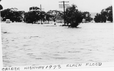
Photograph, B/W photograph 1973 Flash Flood on Calder Highway
... B/W photograph 1973 Flash Flood on Calder Highway...1973 Flash Flood on Calder Highway...Unframed B/W photograph 1973 Flash Flood on Calder Highway...Flood Calder Highway, Flash flood...Charlton Golden Grains Museum Inc 1 High Street Charlton goldfields 1973 Flash Flood on Calder Highway Charlton Calder Highway Floods Flood Calder Highway, Flash flood Unframed B/W photograph 1973 Flash Flood on Calder Highway B/W photograph 1973 Flash Flood on Calder Highway Photograph Photograph ...1973 Flash Flood on Calder HighwayUnframed B/W photograph 1973 Flash Flood on Calder HighwayFlood Calder Highway, Flash floodcharlton, calder highway, floods -
 Warrnambool and District Historical Society Inc.
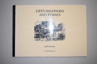
Book, Jack Rooke, Life’s Highways and Byways, 1995
... Life’s Highways and Byways...The pages contain some sketches and black and white photographs. Life’s Highways and Byways Book Jack Rooke ...This is a booklet written by Jack Rooke about his life. Born in 1910 Jack Rooke faced early the challenges of living in the bush in the Camperdown and Panmure areas. He describes the difficulties of the small farmer and the tough living conditions. He also records the struggle to survive during the Depression years in the 1930s and his heartache after his farm was burnt out in the Ash Wednesday fires. Rooke’s story mirrors that of many settlers in the Western District in the early to mid 20th century and so he has produced an important social history in a simple but compelling manner. This booklet is of considerable importance as it gives the details of the life of one person facing the challenges of living in the bush in the district around Warrnambool in the 20th century. It is a simple but great social history that should be read by the younger generation today.This is a soft cover book of 40 pages. It has been self-published and home-produced with a buff-coloured cover and a plastic overlay. The cover has a black and white illustration. The pages contain some sketches and black and white photographs. early 20th century settlement in the warrnambool district, history of warrnambool, jack rooke, camperdown, panmure -
Lakes Entrance Historical Society
Book, Synan Peter, Highways of Water- How shipping on the Lakes shaped Gippsland, 1989
... Highways of Water- How shipping on the Lakes shaped Gippsland...Lakes Entrance Historical Society 4 Marine Parade Lakes Entrance gippsland Ships and Shipping Land Settlement Waterways A history of the Gippsland Lakes Victoria as a transport system for trade with in the lakes and river systems, and coastal and interstate trade Highways of Water- How shipping on the Lakes shaped Gippsland Book Synan Peter ...A history of the Gippsland Lakes Victoria as a transport system for trade with in the lakes and river systems, and coastal and interstate tradeships and shipping, land settlement, waterways -
 Whitehorse Historical Society Inc.
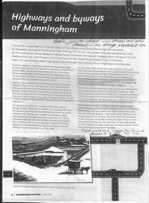
Article - Manningham Matters, Dr Richard Lay, Highways and Byways of Manningham, June 2021
... Highways and Byways of Manningham...August Schwerkolt walked between his properties at Northcote and Mitcham and probably crossed the Yarra River at the Banksia St bridge and took the ridge route which is now the Manningham, Doncaster and Mitcham Roads. Highways and Byways of Manningham Article Manningham Matters Dr Richard Lay Manningham Matters ...August Schwerkolt walked between his properties at Northcote and Mitcham and probably crossed the Yarra River at the Banksia St bridge and took the ridge route which is now the Manningham, Doncaster and Mitcham Roads.August Schwerkolt walked between his properties at Northcote and Mitcham and probably crossed the Yarra River at the Banksia St bridge and took the ridge route which is now the Manningham, Doncaster and Mitcham Roads.non-fictionAugust Schwerkolt walked between his properties at Northcote and Mitcham and probably crossed the Yarra River at the Banksia St bridge and took the ridge route which is now the Manningham, Doncaster and Mitcham Roads.schwerkolt august, mitcham, doncaster road, mitcham road -
 Melbourne Tram Museum
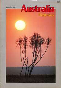
Magazine, Kevin Weldon, "Australia Highways", Jan 1985
... "Australia Highways"...Yields information the Canberra Tradesmen club. trams tramways Canberra Tradesmen Club Canberra tram 156 tram 447 Transporting Trams Magazine - 52 A4 full colour pages centre stapled - Vol 1 No 1 - January 1985 "Australia Highways" Magazine Kevin Weldon Robert Beattie ...Magazine dated Jan 1985, the first and apparently the only issue published with articles on Fort Denison, trams for the Canberra Tradesmen's club, Robyn Archer, Pyjama Cricket, the glory of Kakadu, the longest backyard fence in the world, Australia takes to the beaches and a Calendar of events around Australia. Published by Kevin Weldon & Associate - see reference. The article on the trams at the Tradesmen's club including the moving of Adelaide D156, interior photos of trams at the club including W2 447. Written by Robert Beattie.Yields information the Canberra Tradesmen club.Magazine - 52 A4 full colour pages centre stapled - Vol 1 No 1 - January 1985trams, tramways, canberra tradesmen club, canberra, tram 156, tram 447, transporting trams -
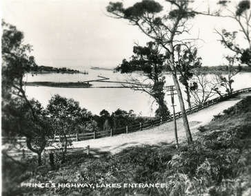
 Lakes Entrance Historical Society
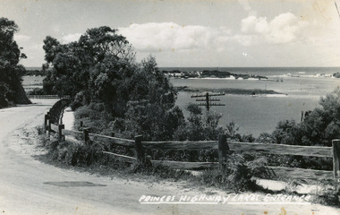
Postcard - Jemmys Point Lakes Entrance c1925, Rose Series
... Post and rail fence beside highway and no vegetation on sand dunes eastern part of Cunninghame Arm...Black and white postcard showing view of Cunninghame Arm from Jemmys Point, gravel Princes Highway, North Arm bridge and end of town Lakes Entrance Victoria...Nearing Lakes Entrance on the Princes Highway...Post and rail fence beside highway and no vegetation on sand dunes eastern part of Cunninghame Arm Township Waterways Nearing Lakes Entrance on the Princes Highway Black and white postcard showing view of Cunninghame Arm from Jemmys Point, gravel Princes Highway, North Arm bridge and end of town Lakes Entrance Victoria Postcard Jemmys Point Lakes Entrance c1925 Rose Series ...Post and rail fence beside highway and no vegetation on sand dunes eastern part of Cunninghame ArmBlack and white postcard showing view of Cunninghame Arm from Jemmys Point, gravel Princes Highway, North Arm bridge and end of town Lakes Entrance VictoriaNearing Lakes Entrance on the Princes Highwaytownship, waterways -
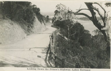 Lakes Entrance Historical Society
Postcard - Princes Highway Lakes Entrance, 1930 c
... Princes Highway Jemmys Point showing gravel road post and rail fence freshly excavated cliff with Entrance glimpses in distance Lakes Entrance Victoria. ...Black and white postcard taken of Princes Highway Jemmys Point showing gravel road post and rail fence freshly excavated cliff with Entrance glimpses in distance Lakes Entrance Victoria...Looking Down the Princes Highway Lakes Entrance...Number 04204.1 Civil Engineering Roads and Streets Fences Looking Down the Princes Highway Lakes Entrance Black and white postcard taken of Princes Highway Jemmys Point showing gravel road post and rail fence freshly excavated cliff with Entrance glimpses in distance Lakes Entrance Victoria Postcard Princes Highway Lakes Entrance ...Princes Highway Jemmys Point showing gravel road post and rail fence freshly excavated cliff with Entrance glimpses in distance Lakes Entrance Victoria. Also a second black and white postcard taken much later of Princes Highway Jemmys Point Lakes Entrance showing sealed road with double lines in centre, post and rail fence, Entrance in distance. Donor Susan Samuel 2 January 2015. Number 04204.1Black and white postcard taken of Princes Highway Jemmys Point showing gravel road post and rail fence freshly excavated cliff with Entrance glimpses in distance Lakes Entrance VictoriaLooking Down the Princes Highway Lakes Entrancecivil engineering, roads and streets, fences -
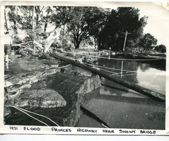 Orbost & District Historical Society
black and white photograph, February 1971
... This photograph was taken near the Snowy River Bridge on the the old Princes Highway in Orbost, near the caravan park. The 1971 flood was the the worst flood on record. ...A black / white photograph of debris, fallen power lines, a tree across the highway and floodwaters across the road....on front at bottom - handwritten in upper case print - " 1971 FLOOD PRINCES HIGHWAY NEAR SNOWY BRIDGE"...Princes Highway, Orbost, e, Victoria, Australia...Floods have been an integral part of Orbost's history for hundreds of years. floods-orbost-1971 on front at bottom - handwritten in upper case print - " 1971 FLOOD PRINCES HIGHWAY NEAR SNOWY BRIDGE" A black / white photograph of debris, fallen power lines, a tree across the highway and floodwaters across the road. black and white photograph ...This photograph was taken near the Snowy River Bridge on the the old Princes Highway in Orbost, near the caravan park. The 1971 flood was the the worst flood on record. At Jarrahmond it was at least 11 metres and up to one and a half kilometres wide on the flats causing enormous damage to the flood plain. Records say that "The brown floodwater stain in Bass Strait could be seen from passing airliners." Considerable damage was done to railway infrastructure, roads and farms. More information from the APRIL, 2008 newsletter by John Phillips. (see orbosthistory.com.au)This is pictorial evidence of a significant local event. Floods have been an integral part of Orbost's history for hundreds of years.A black / white photograph of debris, fallen power lines, a tree across the highway and floodwaters across the road.on front at bottom - handwritten in upper case print - " 1971 FLOOD PRINCES HIGHWAY NEAR SNOWY BRIDGE"floods-orbost-1971 -
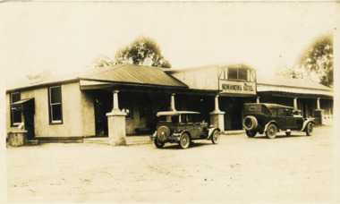 Lakes Entrance Historical Society
Postcard - Nowa Nowa Hotel 1930 c
... ...Highways...Nowa Nowa Hotel Prince's Highway...Hotels Vehicles Tourism Highways Nowa Nowa Hotel Prince's Highway Black and white postcard of Nowa Nowa Hotel with two 1930's cars parked out front Postcard Nowa Nowa Hotel 1930 c ...Black and white postcard of Nowa Nowa Hotel with two 1930's cars parked out frontNowa Nowa Hotel Prince's Highwayhotels, vehicles, tourism, highways -
 Robin Boyd Foundation
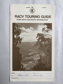
Map, RACV, RACV Touring Guide
... Strip maps and route information for via the Maroondah Highway from melbourne to benalla....In blue pan Maroondah Highway....Robin Boyd Foundation 290 Walsh Street South Yarra melbourne Walsh St library In blue pan Maroondah Highway. Strip maps and route information for via the Maroondah Highway from melbourne to benalla. ...Strip maps and route information for via the Maroondah Highway from melbourne to benalla.In blue pan Maroondah Highway.walsh st library -
 Lakes Entrance Historical Society
Postcard - Princes Highway Kalimna c1930, Valentine Series
... Black and white postcard of a bend in the Princes Highway as it winds around Jemmys Point, car parked beside highway, two people leaning on post and rail fence, Bullock Island and Lakes Entrance in the distance. ...Princes Highway Lakes Entrance...Fences Transport Roads and Streets Princes Highway Lakes Entrance Black and white postcard of a bend in the Princes Highway as it winds around Jemmys Point, car parked beside highway, two people leaning on post and rail fence, Bullock Island and Lakes Entrance in the distance. ...Black and white postcard of a bend in the Princes Highway as it winds around Jemmys Point, car parked beside highway, two people leaning on post and rail fence, Bullock Island and Lakes Entrance in the distance. Lakes Entrance VictoriaPrinces Highway Lakes Entrancefences, transport, roads and streets -
 Lakes Entrance Historical Society
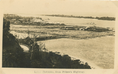
Postcard - Lakes Entrance from Princes Highway c1925
... Sepia postcard of a view of Lakes Entrance from the highway near Jemmy's Point...Lakes Entrance from Princes Highway...Lakes Entrance Historical Society 4 Marine Parade Lakes Entrance gippsland Settlement Topography Waterways Hotels Lakes Entrance from Princes Highway Sepia postcard of a view of Lakes Entrance from the highway near Jemmy's Point Postcard Lakes Entrance from Princes Highway c1925 ...Sepia postcard of a view of Lakes Entrance from the highway near Jemmy's PointLakes Entrance from Princes Highwaysettlement, topography, waterways, hotels -
Lakes Entrance Historical Society
Map - Kalimna
... ...Highways...Map shows reserve, private streets and Government roads in the township of Kalimna. Shows Princes Highway...Shows Princes Highway Map Kalimna ...Map shows reserve, private streets and Government roads in the township of Kalimna. Shows Princes Highwayroads and streets, township, highways -
 Flagstaff Hill Maritime Museum and Village
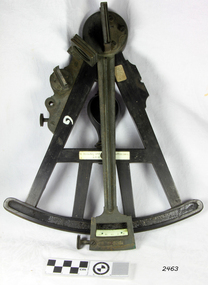
Octant, Late 18th to mid-19th century
... (Henry Hemsley 1, 1786-89, who had premises at 85 Fleet St London and Henry Hemsley 2, 1828-56), whose workshop was at 135-138 Radcliff Highway London. Therefore, based on the inscribed workshop address Henry Hemsley 2 is responsible for making this example....Hemsley 135-138 Ratliff Highway, London", no box...Hemsley 135-138 Ratcliff Highway, London"...Hemsley 135-138 Ratliff Highway, London", no box Octant H. Hemsley ...An Octant is a doubly reflecting navigation instrument used primarily by sailors to measure the angular distance between two visible objects and was a forerunner of the sextant. The name comes from the Latin octo, or “one-eighth of a circle,” for the Octant’s arc which spans 45°, or one-eighth of a circle. The primary use of an Octant is to measure the angle between an astronomical object and the horizon for the purposes of celestial navigation. The estimation of this angle is known as sighting or shooting the object, or taking a sight. The angle, and the time when it was measured, can be used to calculate a position line on a nautical chart (latitude), for example, sighting the Sun at noon or Polaris at night (in the Northern Hemisphere) gives an angle by which the latitude can then be estimated. Sighting the height of a landmark on land can also give a measure of distance. History: The principle of the Octant as an instrument to measure ones latitude was first implemented around 1742-present but was superseded by the improvement of the octant to a sextant, a very similar instrument, better made and able to measure bigger angles 120°, allowing the measurement of Luna distances to give longitude when used with an accurate chronometer. The sextant started to appear around 1730 and had been attributed to by John Hadley (1682–1744) and Thomas Godfrey (1704–1749), but reference to the sextant was also found later in the unpublished writings of Isaac Newton (1643–1727). Earlier links can be found to Bartholomew Gosnold (1571–1607) indicating that the use of a Sextant for nautical navigation predates Hadley's implementation. In 1922, the sextant was modified for aeronautical navigation by Portuguese navigator and naval officer Gago Coutinho. Henry Hemsley was a lesser-known instrument maker and optician working in London in the late 17th and early 18th century. However, it should be noted that there were two Henry Hemsley opticians and instrument makers around this period. (Henry Hemsley 1, 1786-89, who had premises at 85 Fleet St London and Henry Hemsley 2, 1828-56), whose workshop was at 135-138 Radcliff Highway London. Therefore, based on the inscribed workshop address Henry Hemsley 2 is responsible for making this example.The octant is representative of its type and although not fully complete it demonstrates how 18th and 19th-century mariners determined their latitude on a chart to navigate their way across the world's oceans in the 18th and 19th century. It also demonstrates the skill and workmanship of the early instrument makers that operated from London at this time and provided most of the navigational instrumentation use by commercial and military navies of the time.Octant, ebony wooden frame and handle. Scale is missing from recess in frame. "H. Hemsley 135-138 Ratliff Highway, London", no box"H. Hemsley 135-138 Ratcliff Highway, London"flagstaff hill, warrnambool, shipwrecked-coast, flagstaff-hill, flagstaff-hill-maritime-museum, maritime-museum, shipwreck-coast, flagstaff-hill-maritime-village, navigation, navigational instrument, instrument used for navigation, sextant, henry hemsley, instrument maker, london, octant -
 Glen Eira Historical Society
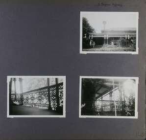
Album - Album page, 31 Nepean Highway, Circa 1972
... 31 Nepean Highway...Page 140 of Photograph Album with three (landscape) photographs of Roseneath on Nepean Highway. ...Handwritten: 31 Nepean Highway [top right] / 140 [bottom right]...31 Nepean Highway, Elsternwick, Melbourne, Victoria, Australia..."Roseneath" compares with "Cumbernauld" (pre 1872) at 504 Hawthorn Road and "Glenmoore" (1870) at 1 St Georges Road. trevor hart verandah chimneys porch decorative brackets single storey cast iron columns return verandah garden nepean highway roseneath italianate 1870's elsternwick cast iron work victorian style polychrome bricks william millar slate roofs brick houses house names Handwritten: 31 Nepean Highway [top right] / 140 [bottom right] Page 140 of Photograph Album with three (landscape) photographs of Roseneath on Nepean Highway. 31 Nepean Highway Album Album page ...This photograph is part of the Caulfield Historical Album 1972. This album was created in approximately 1972 as part of a project by the Caulfield Historical Society to assist in identifying buildings worthy of preservation. The album is related to a Survey the Caulfield Historical Society developed in collaboration with the National Trust of Australia (Victoria) and Caulfield City Council to identify historic buildings within the City of Caulfield that warranted the protection of a National Trust Classification. Principal photographer thought to be Trevor Hart, member of Caulfield Historical Society. Most photographs were taken between 1966-1972 with a small number of photographs being older and from unknown sources. All photographs are black and white except where stated, with 386 photographs over 198 pages. Victorian Heritage Database - HO48 - 31 Nepean Highway Elsternwick https://vhd.heritagecouncil.vic.gov.au/places/35531 (at 15/08/2021) "Roseneath" at 31 Point Nepean Road is a bi-chromatic Italianate villa built for William Millar in 1874. It is aesthetically and historically important. "Roseneath's aesthetic value derives from its survival as a substantially intact bi-chromatic brick villa, distinguished by the symmetrical north and south facing bays and by its spacious grounds. Its historical value rests on its comparatively early date and link with Shire councillor William Millar. The choice of bi-chromatic brick, which was highly fashionable at the time, is also of note. "Roseneath" compares with "Cumbernauld" (pre 1872) at 504 Hawthorn Road and "Glenmoore" (1870) at 1 St Georges Road.Page 140 of Photograph Album with three (landscape) photographs of Roseneath on Nepean Highway. Handwritten: 31 Nepean Highway [top right] / 140 [bottom right]trevor hart, verandah, chimneys, porch, decorative brackets, single storey, cast iron columns, return verandah, garden, nepean highway, roseneath, italianate, 1870's, elsternwick, cast iron work, victorian style, polychrome bricks, william millar, slate roofs, brick houses, house names -
 Hume City Civic Collection
Photograph
... The old Calder Highway before the construction of the duplication of the Calder Highway between the Railway crossing and Plumpton Road....A coloured panoramic view of the old Caler Highway at Diggers Rest. It is unmounted....Hume City Civic Collection 44 Macedon Street Sunbury melbourne The old Calder Highway before the construction of the duplication of the Calder Highway between the Railway crossing and Plumpton Road. old calder highway diggers rest plumpton road railways george evans collection A coloured panoramic view of the old Caler Highway at Diggers Rest. ...The old Calder Highway before the construction of the duplication of the Calder Highway between the Railway crossing and Plumpton Road.A coloured panoramic view of the old Caler Highway at Diggers Rest. It is unmounted.old calder highway, diggers rest, plumpton road, railways, george evans collection -
 Lakes Entrance Historical Society
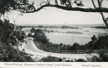
Postcard - Princes Highway, Lakes Entrance, Victoria, Bulmer H D, 1930C
... Black and white postcard of Princes Highway, entrance and Bullock Island taken from Kalimna Hill Lakes Entrance, Victoria...Princes Highway, Entrance and Bullock Island, Lakes Entrance...Lakes Entrance Historical Society 4 Marine Parade Lakes Entrance gippsland 2x black and white small format postcards both 6x9|1x tinted small format postcard 6x9|All above show inscription 'Road and Entrance' Coast Fences Roads and Streets Princes Highway, Entrance and Bullock Island, Lakes Entrance Black and white postcard of Princes Highway, entrance and Bullock Island taken from Kalimna Hill Lakes Entrance, Victoria Postcard Princes Highway, Lakes Entrance, Victoria Bulmer H D ...2x black and white small format postcards both 6x9|1x tinted small format postcard 6x9|All above show inscription 'Road and Entrance'Black and white postcard of Princes Highway, entrance and Bullock Island taken from Kalimna Hill Lakes Entrance, VictoriaPrinces Highway, Entrance and Bullock Island, Lakes Entrancecoast, fences, roads and streets -
 Rutherglen Historical Society
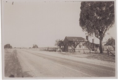
Photograph - Image, 1949
... Black and white photograph of a weatherboard building set close to the edge of a highway...On back of photo: "Old miners Post Office on Murray Valley Highway near Rutherglen 1949"...Rutherglen Historical Society Murray Street Rutherglen high-country miners post office murray valley highway post offices gold mining On back of photo: "Old miners Post Office on Murray Valley Highway near Rutherglen 1949" Black and white photograph of a weatherboard building set close to the edge of a highway Photograph Image ...Black and white photograph of a weatherboard building set close to the edge of a highwayOn back of photo: "Old miners Post Office on Murray Valley Highway near Rutherglen 1949"miners post office, murray valley highway, post offices, gold mining -
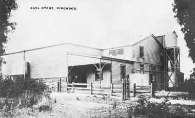 Ringwood and District Historical Society
Photograph, Ringwood Cool Store, corner of Wantirna Road and Maroondah Highway, Ringwood - c.1920s
... Ringwood Cool Store, corner of Wantirna Road and Maroondah Highway, Ringwood - c.1920s....Old Coolstores in Maroondah Highway, corner Wantirna Road...Typed below photograph, "Old Coolstores in Maroondah Highway, corner Wantirna Rd." Written on photograph, "Cool Store, Ringwood"....Old Coolstores in Maroondah Highway, corner Wantirna Road Ringwood Cool Store, corner of Wantirna Road and Maroondah Highway, Ringwood - c.1920s. ...Old Coolstores in Maroondah Highway, corner Wantirna RoadTyped below photograph, "Old Coolstores in Maroondah Highway, corner Wantirna Rd." Written on photograph, "Cool Store, Ringwood".coolstore -
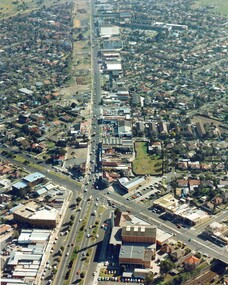 City of Kingston
Photograph - Colour, c. 1982
... This aerial photograph of South Road and Nepean Highway, Moorabbin shows the area where houses and shops on the south side of the Nepean Highway have demolished for the widening of the highway. ...Colour photograph of an aerial view of South Road and Nepean Highway, Moorabbin. The image shows houses on the south side of the Nepean Highway that have demolished for widening of road. ...City of Kingston Parkdale Library 96 Parkers Road, Parkdale Parkdale This aerial photograph of South Road and Nepean Highway, Moorabbin shows the area where houses and shops on the south side of the Nepean Highway have demolished for the widening of the highway. ...This aerial photograph of South Road and Nepean Highway, Moorabbin shows the area where houses and shops on the south side of the Nepean Highway have demolished for the widening of the highway. The pressures of rapid urban development in Moorabbin and beyond, especially to the south of Moorabbin caused bottlenecks and delays, especially at the South Road and Nepean Highway intersection, hence the scheme to widen Nepean Highway.The pressures of rapid urban development in terms of people, housing construction, industrial development and commercial activity, in Moorabbin and beyond, especially to the south would put pressure on road infrastructure in the region. In the early 1980s, a major road expansion of the Nepean Highway was implemented to increase capacity on this major thoroughfare for vehicle commuters. Car use had also increased with commuters from the increasingly populous southern suburbs travelling to their place of work in the Melbourne CBD.Colour photograph of an aerial view of South Road and Nepean Highway, Moorabbin. The image shows houses on the south side of the Nepean Highway that have demolished for widening of road. It features housing and commercial buildings looking north towards Cummins Road.Handwritten blue ink: 82 - 5452 - 11 Handwritten red ink: 112% Handwritten black ink: Ch. 7nepean highway, south road, moorabbin, roads, transport, infrastructure -
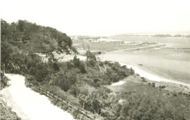
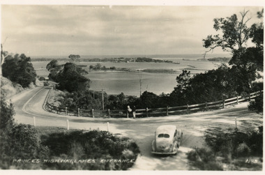
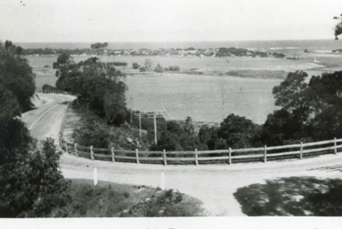
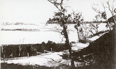 Lakes Entrance Historical Society
Photograph - The Entrance Lakes Entrance Victoria c1910
... Black and white photograph of the Princes Highway at Kalimna. It shows the road around Jemmys Point. ...The Entrance from Princes Highway...Roads and Streets Vegetation Fences Waterways The Entrance from Princes Highway Black and white photograph of the Princes Highway at Kalimna. ...Black and white photograph of the Princes Highway at Kalimna. It shows the road around Jemmys Point. Bullock Island and a distant view of the man made entrance. Gumtrees along roadside. Lakes Entrance VictoriaThe Entrance from Princes Highwayroads and streets, vegetation, fences, waterways -
 Lakes Entrance Historical Society
Postcard - Princes Highway Kalimna c1920, Bulmer H D
... Tinted postcard of a bend in the Princes Highway, Jemmy's Point. It shows the road between the steep cutting and post and rail fence. ...Princes Highway, Lakes Entrance...Black and white copy same size Topography Waterways Roads and Streets Princes Highway, Lakes Entrance Tinted postcard of a bend in the Princes Highway, Jemmy's Point. ...Black and white copy same sizeTinted postcard of a bend in the Princes Highway, Jemmy's Point. It shows the road between the steep cutting and post and rail fence. Glimpse of footbridge to Bullock Island, entrance and hummocks. Lakes Entrance VictoriaPrinces Highway, Lakes Entrance topography, waterways, roads and streets -
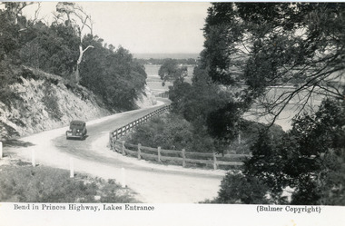 Lakes Entrance Historical Society
Postcard - Princes Highway Kalimna, Bulmer H D, 1935c
... Black and white postcard of the Princes Highway as it winds around Jemmys Point. A motor car driving up the hill between steep road cutting and post and rail fence. ...Bend in Princes Highway, Lakes Entrance A pretty bend in the Princes Highway ...Fences Roads and Streets Bend in Princes Highway, Lakes Entrance A pretty bend in the Princes Highway Black and white postcard of the Princes Highway as it winds around Jemmys Point. ...Black and white postcard of the Princes Highway as it winds around Jemmys Point. A motor car driving up the hill between steep road cutting and post and rail fence. View of the lake and ocean in the distance. Lakes Entrance Victoria . Plus a second postcard of the same sceneBend in Princes Highway, Lakes Entrance A pretty bend in the Princes Highway fences, roads and streets -
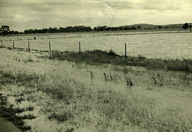 Charlton Golden Grains Museum Inc
Photograph, Charlton Tribune, B/W photograph of 1971 flood, Nov 1971
... Paddocks and roadside along Calder Highway....Paddocks and roadside along Calder Highway....Calder Highway, Charlton, Victoria, Australia...Paddocks and roadside along Calder Highway. Charlton Calder Highway Floods Unframed photograph of 1971 flood. ...1971 flood at Charlton. Paddocks and roadside along Calder Highway.Unframed photograph of 1971 flood. Paddocks and roadside along Calder Highway.charlton, calder highway, floods -
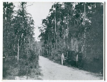 Orbost & District Historical Society
black and white photograph, 1913
... This photograph shows the regrowth of vegetation on the road between Genoa and the border - now the Princes Highway....on back - " Princes Highway showing the regrowth.....1913"...Orbost & District Historical Society Ruskin Street Orbost gippsland This photograph shows the regrowth of vegetation on the road between Genoa and the border - now the Princes Highway. This is a pictorial record of the main road from Orbost to the New South border, The Princes Highway, in the early 20th century. princes-highway-genoa transport on back - " Princes Highway showing the regrowth.....1913" A large black / white photograph of a bush road wwith a vehicle and a man on the side of it. black and white photograph ...This photograph shows the regrowth of vegetation on the road between Genoa and the border - now the Princes Highway.This is a pictorial record of the main road from Orbost to the New South border, The Princes Highway, in the early 20th century.A large black / white photograph of a bush road wwith a vehicle and a man on the side of it.on back - " Princes Highway showing the regrowth.....1913"princes-highway-genoa transport -
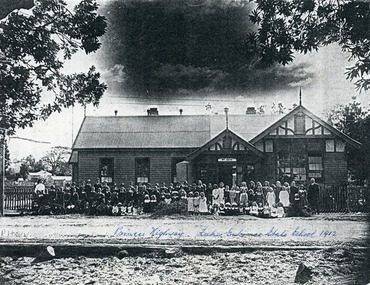 Lakes Entrance Historical Society
Photograph - Lakes Entrance State School Buildings c1912
... Three photographs of black and white print of Lakes Entrance State School no 2672 with teachers and children in front of building facing the lake, highway in front. Lakes Entrance Victoria...Princes Highway, Lakes Entrance State School c1912...Was situated on the cnr of the Esplanade and Bulmer Street Schools Buildings Princes Highway, Lakes Entrance State School c1912 Three photographs of black and white print of Lakes Entrance State School no 2672 with teachers and children in front of building facing the lake, highway in front. ...Was situated on the cnr of the Esplanade and Bulmer StreetThree photographs of black and white print of Lakes Entrance State School no 2672 with teachers and children in front of building facing the lake, highway in front. Lakes Entrance VictoriaPrinces Highway, Lakes Entrance State School c1912schools, buildings -
 Lakes Entrance Historical Society
Postcard - View from Jemmys Point Lakes Entrance c1950, Bulmer H D, 1950c
... Black and white postcard of the Princes Highway Jemmys Point, showing Bullock Island between North Arm and Cunninghame Arm, distant view of the entrance from Bass Strait to the Gippsland Lakes. ...Princes Highway and a view of the Entrance...Vegetation Roads and Streets Princes Highway and a view of the Entrance Black and white postcard of the Princes Highway Jemmys Point, showing Bullock Island between North Arm and Cunninghame Arm, distant view of the entrance from Bass Strait to the Gippsland Lakes. ...Also one other postcard same donated by M & V Carpenter in spares box.Black and white postcard of the Princes Highway Jemmys Point, showing Bullock Island between North Arm and Cunninghame Arm, distant view of the entrance from Bass Strait to the Gippsland Lakes. Post and rail fence along roadside. Lakes Entrance VictoriaPrinces Highway and a view of the Entrance vegetation, roads and streets -
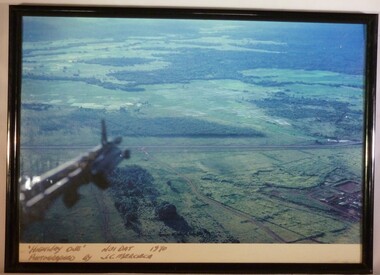 National Vietnam Veterans Museum (NVVM)
Photograph - A Framed Coloured Photograph, 'Highway One' Nui Dat 1970. Photographed by J.C. Mercieca, c.1970
... 'Highway One' Nui Dat 1970. Photographed by J.C. ...A colour photograph in a black frame titled "Highway One" Nui Dat 1970. Below the part of the helicopter that is in the photograph you can see the lush green landscape...."Highway One" Nui Dat 1970 Photographed by J.C. ...'Highway One' Nui Dat 1970. Photographed by J.C. ...This photograph was taken by Cpl Joseph Charles Mercieca (A316866) who served with the Royal Australian Air Force. He served in Vietnam with No. 1 Operational Support Unit from July 1969 to July 1970.A colour photograph in a black frame titled "Highway One" Nui Dat 1970. Below the part of the helicopter that is in the photograph you can see the lush green landscape."Highway One" Nui Dat 1970 Photographed by J.C. Merciecacpl joseph charles mercieca, a316866, royal australian air force, no.1 operational support unit, photograph, highway one, nui dat -
 Lakes Entrance Historical Society
Postcard - Princes Highway at Jemmys Point. Lakes Entrance Victoria, 1930c
... Black and white small format postcard of the Princes Highway at Jemmys Point. It shows the road winding around the hill between the scrub covered hill and the post and rail guard fence, Bullock Island and rock groynes in the lake also entrance in distance. ...Princes Highway, Lakes Entrance...Lakes Entrance Historical Society 4 Marine Parade Lakes Entrance gippsland Also faded copy identical image Islands Fences Roads and Streets Princes Highway, Lakes Entrance Black and white small format postcard of the Princes Highway at Jemmys Point. ...Also faded copy identical imageBlack and white small format postcard of the Princes Highway at Jemmys Point. It shows the road winding around the hill between the scrub covered hill and the post and rail guard fence, Bullock Island and rock groynes in the lake also entrance in distance. Lakes Entrance VictoriaPrinces Highway, Lakes Entranceislands, fences, roads and streets