Showing 1627 items matching "historic buildings and sites"
-
 Whitehorse Historical Society Inc.
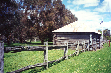
Photograph, Historic Buildings and sites, 1966
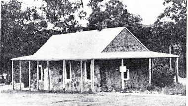
... Historic Buildings and sites...Whitehorse Historical Society Inc. 2-10 Deep Creek Road Mitcham melbourne schwerkolt cottage Extract from Historic Buildings of Victoria showing Schwerkolt Cottage Historic Buildings and sites Photograph Photograph ...Extract from Historic Buildings of Victoria showing Schwerkolt Cottageschwerkolt cottage -
 Whitehorse Historical Society Inc.
Article, Kilns Inspected, 1994
... Historic Buildings Council believes the old Kilns and Chimneys on the Monier site in Mitcham Road are of State significance and should be retained, but the Company has appealed to Mr. ...Article in Nunawading Gazette, Historic Buildings Council believes the old Kilns and Chimneys on the Monier site in Mitcham Road are of State significance and should be retained, but the Company has appealed to Mr. ...Article in Nunawading Gazette, Historic Buildings Council believes the old Kilns and Chimneys on the Monier site in Mitcham Road are of State significance and should be retained, but the Company has appealed to Mr. ...Printedd Article in Nunawading Gazette.Article in Nunawading Gazette, Historic Buildings Council believes the old Kilns and Chimneys on the Monier site in Mitcham Road are of State significance and should be retained, but the Company has appealed to Mr. MacLellan to allow them to demolish.Printedd Article in Nunawading Gazette.pottery kilns, monier limited, historic buildings council -
Lakes Entrance Historical Society
Book, Historic Buildings Council, Victoria, Victorian Heritage Register, 1995
... A register of historic buildings, sites and shipwrecks in Victoria drawn from information available at 26 June 1995, supplied by Historic Buildings Council and Maritime Heritage unit of Heritage Victoria. ...Lakes Entrance Historical Society 4 Marine Parade Lakes Entrance gippsland Heritage Shipwrecks Architecture A register of historic buildings, sites and shipwrecks in Victoria drawn from information available at 26 June 1995, supplied by Historic Buildings Council and Maritime Heritage unit of Heritage Victoria. ...A register of historic buildings, sites and shipwrecks in Victoria drawn from information available at 26 June 1995, supplied by Historic Buildings Council and Maritime Heritage unit of Heritage Victoria. This is now the province of the Heritage Council, Victoriaheritage, shipwrecks, architecture -
 Sunshine and District Historical Society Incorporated
Archive - Historical Building Council
... Brochure Protecting Victorias Heritage by Historic Building Council Guidelines for Participants February 1991 Historic Buildings Council Hearings Flyer HBC Registration what it means Brochure today a promise to the future Winter 1995 Booklet Historic Buildings Council 1994 to 1995 Annual Report Booklet Historic Buildings Council Victoria Booklet The Parliament of Victoria and Parliament House Thirteenth Edition 1980 Brochure today A new Heritage Council Spring 1993 Brochure today a promise to the future Winter 1994 An Act to make Provision with respect ot the Preservation of Buildings Works and Objects of Historic or Architectural Importance or Interest 14 May 1974 Letter 2 April 1987 from Sunshine and District Historical Society to Historic Buildings Council about Preservation of the Massey Ferguson site Sunshine Letter 14 April 1987 from Historic Buildings Council to Sunshine and District Historical Society Letter 18 May 1987 from Historic Buildings Council to Sunshine and District Historical Society about Massey Ferguson Complex Devonshire Road Sunshine...Historical Building Brochure Protecting Victorias Heritage by Historic Building Council Guidelines for Participants February 1991 Historic Buildings Council Hearings Flyer HBC Registration what it means Brochure today a promise to the future Winter 1995 Booklet Historic Buildings Council 1994 to 1995 Annual Report Booklet Historic Buildings Council Victoria Booklet The Parliament of Victoria and Parliament House Thirteenth Edition 1980 Brochure today A new Heritage Council Spring 1993 Brochure today a promise to the future Winter 1994 An Act to make Provision with respect ot the Preservation of Buildings Works and Objects of Historic or Architectural Importance or Interest 14 May 1974 Letter 2 April 1987 from Sunshine and District Historical Society to Historic Buildings Council about Preservation of the Massey Ferguson site Sunshine Letter 14 April 1987 from Historic Buildings Council to Sunshine and District Historical Society Letter 18 May 1987 from Historic Buildings Council to Sunshine and District Historical Society about Massey Ferguson Complex Devonshire Road Sunshine Collection of documents published by the Historical Building Council Archive Historical Building Council ...Brochure Protecting Victorias Heritage by Historic Building Council Guidelines for Participants February 1991 Historic Buildings Council Hearings Flyer HBC Registration what it means Brochure today a promise to the future Winter 1995 Booklet Historic Buildings Council 1994 to 1995 Annual Report Booklet Historic Buildings Council Victoria Booklet The Parliament of Victoria and Parliament House Thirteenth Edition 1980 Brochure today A new Heritage Council Spring 1993 Brochure today a promise to the future Winter 1994 An Act to make Provision with respect ot the Preservation of Buildings Works and Objects of Historic or Architectural Importance or Interest 14 May 1974 Letter 2 April 1987 from Sunshine and District Historical Society to Historic Buildings Council about Preservation of the Massey Ferguson site Sunshine Letter 14 April 1987 from Historic Buildings Council to Sunshine and District Historical Society Letter 18 May 1987 from Historic Buildings Council to Sunshine and District Historical Society about Massey Ferguson Complex Devonshire Road Sunshinehistorical, building -
 Sunshine and District Historical Society Incorporated
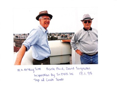
Photograph - McKay factory Bulk Store and the Historic Buildings Council on 17 January 1995, 17/01/1995 12:00:00 AM
... Series of 31 photographs depicting two buildings The Bulk store shows neglect after demolition of factory site and buildings Prior to incorporation into development of land for shopping complex proposed by Woolworths developers This building was one of two subjects for preservation of Historic Buildings Council hearing Developers for Woolworths made submissions for demolition Historic Buildings Council finding was in favour of preservation Reason for inspection was to provide information and input for Sunshine and District Historical Society preservation submission...McKay Massey Harris Massey Ferguson Series of 31 photographs depicting two buildings The Bulk store shows neglect after demolition of factory site and buildings Prior to incorporation into development of land for shopping complex proposed by Woolworths developers This building was one of two subjects for preservation of Historic Buildings Council hearing Developers for Woolworths made submissions for demolition Historic Buildings Council finding was in favour of preservation Reason for inspection was to provide information and input for Sunshine and District Historical Society preservation submission McKay factory Bulk Store and the Historic Buildings Council on 17 January 1995 Photograph McKay factory Bulk Store and the Historic Buildings Council on 17 January 1995 ...Series of 31 photographs depicting two buildings The Bulk store shows neglect after demolition of factory site and buildings Prior to incorporation into development of land for shopping complex proposed by Woolworths developers This building was one of two subjects for preservation of Historic Buildings Council hearing Developers for Woolworths made submissions for demolition Historic Buildings Council finding was in favour of preservation Reason for inspection was to provide information and input for Sunshine and District Historical Society preservation submissionh.v. mckay, h.v. mckay massey harris, massey ferguson -
 Sunshine and District Historical Society Incorporated
Document - Historical Building Hearing by Council and Harvester Site and Massey Ferguson Site and Bulk Store
... Photocopy Aerial Photograph of Harvester Site and Bulk Store|Historical Building Hearing by Council 9 to 16 May about Harvester Site and Bulk Store|Flyer Bulk Store and Electrical Power House December 1994|Letter from Melbournes Living Museum of the West Inc to Historic Buildings Council about Harvester site former Massey Ferguson complex Sunshine|Historic Buildings Act 1981 Report on Application for a Permit|Letter 2 May 1995 from Brimbank City Council to Historic Buildings Council about former Ferguson Site Historic Buildings Register Nos 667|Written submissions on behalf of Burns Bridge Australia Pty Ltd in the matter of the Historic Buildings Act 1981 12 April 1995|Letter 14 February 1995 from National Trust to Historic Buildings Council about Massey Ferguson Site Devonshire Road Sunshine|Written report Allom Lovell and Associates Pty Ltd The Sunshine Harvester Massey Ferguson site and the subject buildings General Overview History of the Development of the Site|Minutes Sunshine and District Historical Society Inc Steering meeting held on 16th March 1993 at the Hunt Club Deer Park|Newspaper article The Advocate 24 March 1999 Sunshine Harvester Festival 27 March 1999|Newspaper article Brimbank Independent 9 September 1997 Harvester site development on target|Newspaper article The Advocate 24 March 1999 Festival to celebrate the Harvester site|Brimbank News Around Brimbank Hidden Treasure McKay Smithy Heritage Trail Sunshine Pictorial map|Newspaper article The Advocate 9 October 1996 Librarys big showpiece A restored 1906 Harvester|Newspaper article The Advocate 8 March 1995 Blockbuster Our movie house to be No 1 16 screen megaplex cinema|Newspaper article Brimbank Independent Appeal expected on Historic Buildings Decision|Newspaper article The Advocate 22 February 1995 Harvester buildings stay|Newspaper article Brimbank Independent 17 January 1995 Demolition Plan Protest action will try to save historic Harvester buildings|Newspaper article Sunshine Advocate 18 January 1995 Showdown Harvester site fight looms|Newspaper article Brimbank Independent 10 January 1995 $70m plans for Harvester site|Newspaper article The Advocate 25 January 1995 Its our heritage|Newspaper article Sunshine Advocate 14 December 1994 Shops cinemas set|Newspaper article The Advocate 10 March 1993 Massey site shop group bids for a slice|Newspaper article The Advocate 28 October 1992 Secret report on MF site Mystery surrounds the future of the Massey Ferguson site and legal action involving an accident|Newspaper article The Advocate 24 April 1991 Grand New City|Newspaper article The Advocate 31 July 1985 Sunshine to get massive facelift|Newspaper article The Western Times 31 July 1985 Big Plans for Sunshine shops centre|Newspaper article Western Independent 9 March 1985 $482000 top up after Sunshine $6.25m buy...Massey Ferguson Sunshine Harvester Works Photocopy Aerial Photograph of Harvester Site and Bulk Store|Historical Building Hearing by Council 9 to 16 May about Harvester Site and Bulk Store|Flyer Bulk Store and Electrical Power House December 1994|Letter from Melbournes Living Museum of the West Inc to Historic Buildings Council about Harvester site former Massey Ferguson complex Sunshine|Historic Buildings Act 1981 Report on Application for a Permit|Letter 2 May 1995 from Brimbank City Council to Historic Buildings Council about former Ferguson Site Historic Buildings Register Nos 667|Written submissions on behalf of Burns Bridge Australia Pty Ltd in the matter of the Historic Buildings Act 1981 12 April 1995|Letter 14 February 1995 from National Trust to Historic Buildings Council about Massey Ferguson Site Devonshire Road Sunshine|Written report Allom Lovell and Associates Pty Ltd The Sunshine Harvester Massey Ferguson site and the subject buildings General Overview History of the Development of the Site|Minutes Sunshine and District Historical Society Inc Steering meeting held on 16th March 1993 at the Hunt Club Deer Park|Newspaper article The Advocate 24 March 1999 Sunshine Harvester Festival 27 March 1999|Newspaper article Brimbank Independent 9 September 1997 Harvester site development on target|Newspaper article The Advocate 24 March 1999 Festival to celebrate the Harvester site|Brimbank News Around Brimbank Hidden Treasure McKay Smithy Heritage Trail Sunshine Pictorial map|Newspaper article The Advocate 9 October 1996 Librarys big showpiece A restored 1906 Harvester|Newspaper article The Advocate 8 March 1995 Blockbuster Our movie house to be No 1 16 screen megaplex cinema|Newspaper article Brimbank Independent Appeal expected on Historic Buildings Decision|Newspaper article The Advocate 22 February 1995 Harvester buildings stay|Newspaper article Brimbank Independent 17 January 1995 Demolition Plan Protest action will try to save historic Harvester buildings|Newspaper article Sunshine Advocate 18 January 1995 Showdown Harvester site fight looms|Newspaper article Brimbank Independent 10 January 1995 $70m plans for Harvester site|Newspaper article The Advocate 25 January 1995 Its our heritage|Newspaper article Sunshine Advocate 14 December 1994 Shops cinemas set|Newspaper article The Advocate 10 March 1993 Massey site shop group bids for a slice|Newspaper article The Advocate 28 October 1992 Secret report on MF site Mystery surrounds the future of the Massey Ferguson site and legal action involving an accident|Newspaper article The Advocate 24 April 1991 Grand New City|Newspaper article The Advocate 31 July 1985 Sunshine to get massive facelift|Newspaper article The Western Times 31 July 1985 Big Plans for Sunshine shops centre|Newspaper article Western Independent 9 March 1985 $482000 top up after Sunshine $6.25m buy Historical Building Hearing by Council and Harvester Site and Massey Ferguson Site and Bulk Store Document Historical Building Hearing by Council and Harvester Site and Massey Ferguson Site and Bulk Store ...Photocopy Aerial Photograph of Harvester Site and Bulk Store|Historical Building Hearing by Council 9 to 16 May about Harvester Site and Bulk Store|Flyer Bulk Store and Electrical Power House December 1994|Letter from Melbournes Living Museum of the West Inc to Historic Buildings Council about Harvester site former Massey Ferguson complex Sunshine|Historic Buildings Act 1981 Report on Application for a Permit|Letter 2 May 1995 from Brimbank City Council to Historic Buildings Council about former Ferguson Site Historic Buildings Register Nos 667|Written submissions on behalf of Burns Bridge Australia Pty Ltd in the matter of the Historic Buildings Act 1981 12 April 1995|Letter 14 February 1995 from National Trust to Historic Buildings Council about Massey Ferguson Site Devonshire Road Sunshine|Written report Allom Lovell and Associates Pty Ltd The Sunshine Harvester Massey Ferguson site and the subject buildings General Overview History of the Development of the Site|Minutes Sunshine and District Historical Society Inc Steering meeting held on 16th March 1993 at the Hunt Club Deer Park|Newspaper article The Advocate 24 March 1999 Sunshine Harvester Festival 27 March 1999|Newspaper article Brimbank Independent 9 September 1997 Harvester site development on target|Newspaper article The Advocate 24 March 1999 Festival to celebrate the Harvester site|Brimbank News Around Brimbank Hidden Treasure McKay Smithy Heritage Trail Sunshine Pictorial map|Newspaper article The Advocate 9 October 1996 Librarys big showpiece A restored 1906 Harvester|Newspaper article The Advocate 8 March 1995 Blockbuster Our movie house to be No 1 16 screen megaplex cinema|Newspaper article Brimbank Independent Appeal expected on Historic Buildings Decision|Newspaper article The Advocate 22 February 1995 Harvester buildings stay|Newspaper article Brimbank Independent 17 January 1995 Demolition Plan Protest action will try to save historic Harvester buildings|Newspaper article Sunshine Advocate 18 January 1995 Showdown Harvester site fight looms|Newspaper article Brimbank Independent 10 January 1995 $70m plans for Harvester site|Newspaper article The Advocate 25 January 1995 Its our heritage|Newspaper article Sunshine Advocate 14 December 1994 Shops cinemas set|Newspaper article The Advocate 10 March 1993 Massey site shop group bids for a slice|Newspaper article The Advocate 28 October 1992 Secret report on MF site Mystery surrounds the future of the Massey Ferguson site and legal action involving an accident|Newspaper article The Advocate 24 April 1991 Grand New City|Newspaper article The Advocate 31 July 1985 Sunshine to get massive facelift|Newspaper article The Western Times 31 July 1985 Big Plans for Sunshine shops centre|Newspaper article Western Independent 9 March 1985 $482000 top up after Sunshine $6.25m buymassey ferguson, sunshine harvester works -
 Dutch Australian Heritage Centre Victoria
Wall Tile (Tegel), Mosa
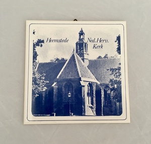
... Tile (b) is an image of the Cruquius Museum on the site of a one-time pumping station....Tile (b) is an image of the Cruquius Museum on the site of a one-time pumping station. Wall Tile (Tegel) Royal Holland Mosa ...(a) and (b) - A set of two ceramic wall tiles featuring historic buildings in the town of Heemstede in the province of North Holland. The images are in shades of blue. Tile (a) depicts the Dutch Reformed Church building (Netherlands Reformed Church). Tile (b) is an image of the Cruquius Museum on the site of a one-time pumping station.On the back of each tile are the words Mosa Royal Holland. Tile (a) also has the numbers 86 and 89 imprinted. -
 Bendigo Historical Society Inc.
Document - BENDIGO HERITAGE WALK DOCUMENT
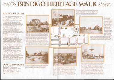
... Each destination has a history of the site described....Each destination has a history of the site described. Document BENDIGO HERITAGE WALK DOCUMENT ...Foldout A3 size tourist document 'Bendigo Heritage Walk' Documents historic buildings along a set heritage walk in the CBD area. Destinations include Charing Cross, Dudley House, Hargreaves Mall, Law Courts, Alexandra Fountain, Rosalind park. Each destination has a history of the site described.bendigo, buildings, heritage walk, bendigo, heritage -
Kew Historical Society Inc
Archive (Sub-series) - Subject File, Community Centre (Kew), 1958
... Properties discussed included 14/16 Princess Street and the hall (Neama) on the site of St Paul’s School. ...Properties discussed included 14/16 Princess Street and the hall (Neama) on the site of St Paul’s School. Community Centre (Kew) Archive Subject File ...Various partiesReference, Research, InformationSecondary Values (KHS Imposed Order)Subject file containing correspondence between office-bearers of the Kew Historical Society and the City of Kew relating to the possibility of purchasing historic buildings from demolition and for use as a community centre and historical society premises or museum. Properties discussed included 14/16 Princess Street and the hall (Neama) on the site of St Paul’s School.community centres -- kew (vic), historical museums - proposedcommunity centres -- kew (vic), historical museums - proposed -
Bendigo Historical Society Inc.
Document - National Trust Collection: Heritage Bid For Central Victorian Goldfields, 1981
... The Bendigo City Council requested a list of historic buildings requiring urgent maintenance to support applications for Australian Government renovation funding and potential inclusion in the Historic Buildings Register. 3084.51c 1981 International Charter for the Restoration of Monuments and Sites (Venice 1966), and the Resolutions of the 5th General Assembly of ICOMOS (Moscow 1978) known as The Burra Charter...The Bendigo City Council requested a list of historic buildings requiring urgent maintenance to support applications for Australian Government renovation funding and potential inclusion in the Historic Buildings Register. 3084.51c 1981 International Charter for the Restoration of Monuments and Sites (Venice 1966), and the Resolutions of the 5th General Assembly of ICOMOS (Moscow 1978) known as The Burra Charter Document National Trust Collection: Heritage Bid For Central Victorian Goldfields ...In November 1981 the City of Bendigo sent out an official invitation and informational outline for two significant events in Bendigo; the Public launch of the World Heritage Bid for the Central Victorian Goldfields and the official launch of the Central Nell Gwynne Poppet Legs Restoration The Central Nell Gwynne Mine operated from 1906 to 1950, reaching a depth of 1,912 feet and yielding 61,884 ounces of gold (approx. $25 million at current prices). The mine was one of the finest on the Bendigo field, with notable engineering features such as tubular steel lattice poppet legs and extensive mining equipment, much of which remains visible on site.Goals are to Stabilize the existing structure, Fabricate internal supports for the poppet legs and winding wheels, Restore original paint colors and install flood lighting. Estimated Cost was $55,000.Project, Team:Supervision: Kurt Bruhn (City Engineer), Colin Campbell Contractor: AllWeld Bendigo; Heritage Consultant: Andrew Ward,Engineering Consultant: Howard Osborne, Project Coordinator: Norm Cameron The restoration was funded by a loan from the Central Goldfields Restoration Fund, as part of a Commonwealth/State Bicentennial Project through the Ministry for Planning and Environment.Invitation to Public Launch, Programme for the launch, Burra Charter - International Charter for the Conservation and Restoration of Monuments and sites, Building included in the initial Register. This item contains the following documents: 3084.51a Invitation from the City of Bendigo to attend the Bendigo Bid for World Heritage of the Goldfields; and the launch of the Central Nell Gwynne Poppet Legs Restoration Project 9th Nov 1989 3084.51b Letters in 1974 from the Natrional Trust. The Bendigo City Council requested a list of historic buildings requiring urgent maintenance to support applications for Australian Government renovation funding and potential inclusion in the Historic Buildings Register. 3084.51c 1981 International Charter for the Restoration of Monuments and Sites (Venice 1966), and the Resolutions of the 5th General Assembly of ICOMOS (Moscow 1978) known as The Burra Charterhistory, national trust bendigo collection, bendigo, central goldfields, nell gwynne mine, north virginia mine -
 Sunbury Family History and Heritage Society Inc.
Photograph, Bill Walls, c1978
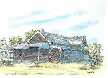
... The artist was Bill Walls who did a number of similar sketches of historic buildings and sites in the Sunbury and Bulla area in the 1970s....The artist was Bill Walls who did a number of similar sketches of historic buildings and sites in the Sunbury and Bulla area in the 1970s. ...The building in the sketch is the former Manse for the Bulla Presbyterian Church. The artist was Bill Walls who did a number of similar sketches of historic buildings and sites in the Sunbury and Bulla area in the 1970s.A photograph of a coloured sketch of a house with bluestone walls and a slate roof. There is a closed-in addition building on one side and a verandah across the front with a lean-to structure on the other end of the building.bulla, presbyterian church, manse -
Kew Historical Society Inc
Archive (Sub-series) - Subject File, Fernhurst (Kew), 1973
... Villa Maria and St Paul’s School currently occupy the site. Part of the site was later subdivided to create Elphinstone Street. ...Villa Maria and St Paul’s School currently occupy the site. Part of the site was later subdivided to create Elphinstone Street. ...Various partiesReference, Research, InformationSecondary Values (KHS Imposed Order)Subject file containing research related to George Wharton and his house Fernhurst, originally situated on the corner of Princess Street and Studley Park Road, but later subdivided. The house was in the 20th century converted into flats and later bought by the Catholic Church, who established St Paul’s School for the Blind on the site. The situation was complicated as the Church also bought the neighbouring Neama and Mandalay. Villa Maria and St Paul’s School currently occupy the site. Part of the site was later subdivided to create Elphinstone Court. The file contains photocopied extracts from histories and detailed research and correspondence between the School, the Kew Historical Society, the National Trust of Victoria, and the Historic Buildings Preservation Council relating to both Neama and Fernhurst. There is a reference in a letter from St Paul’s inviting the Society to collect artefacts from the site. There are no known current items in the collection relating to the collection of these. kew (vic) - history, victorian architects - george wharton, fernhurst (kew), st paul’s school for the blindkew (vic) - history, victorian architects - george wharton, fernhurst (kew), st paul’s school for the blind -
Clunes Museum
Film - DVD, Nine Network Australia, Postcards - Episode 22, 2008, 2008
... Images of significant sites and historic buildings as well as streetscapes and landscapes of Clunes....Images of significant sites and historic buildings as well as streetscapes and landscapes of Clunes. ...Visual programme featuring Widow Twankey's, a local cafe, and the Clunes Museum prior to the redevelopment of the site at 36 Fraser Street, in 2012. Interviews of Tim Hayes, owner of Widow Twankey's and Pat Cook the Curator of Clunes Museum. Images of significant sites and historic buildings as well as streetscapes and landscapes of Clunes.DVD IN WHITE PAPER SLEEVE CHANNEL 9 POSTCARDS, EPISODE 22 "GENERAL SHOW"widow twankey's, pat cook, tim hayes, clunes museum -
 Melbourne Tram Museum
Newspaper - Photocopy, The Age, Roper rejects proposal to protect historic tram engine room, 28-11-1989
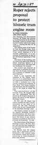
... The Tramways have a small sub-station on the site. Quotes Douglas Hill of the National Trust and Roz Hansen of the Historic Buildings Council. ...The Tramways have a small sub-station on the site. Quotes Douglas Hill of the National Trust and Roz Hansen of the Historic Buildings Council. ...Provides a report from The Age, 28-11-1989 written by Ingrid Swendsen, about the rejection by the Planning and Environment Minister , Tom Roper to protect the former cable tram winding or Engine house on the corner of Bridge and Punt Roads Richmond, despite the recommendation of the Historic Buildings Council to add it to the register. The building was later demolished by the Roads Corporation to widen the intersection. The Tramways have a small sub-station on the site. Quotes Douglas Hill of the National Trust and Roz Hansen of the Historic Buildings Council. Provides a report on the rejection of a recommendation to protect a historic building.Photocopy of a newspaper clipping from The Age 28-11-1989 - Roper rejects proposal to protect historic tram engine roomtrams, tramways, cable trams, engine house, winding house, punt road, bridge road, demolition, richmond, historic buildings council -
 Ballarat Heritage Services
Photograph - Photograph - Colour, Clare Gervasoni, Carisbrook Police Lockup, c1998, c1998
... Standing in the park beside Bucknall Street it is the town's one significant historic building. It was originally built on the police paddock adjacent to the primary school and moved to its present site in 1886. ...Standing in the park beside Bucknall Street it is the town's one significant historic building. It was originally built on the police paddock adjacent to the primary school and moved to its present site in 1886. ...The Logs at Carisbrook was the major gaol in the extensive Carisbrook Police District until 1858, and remained Carisbrook's gaol for low key offenders until about 1900. The lockup was registered by the National Trust on 22/10/1964.Colour photograph of the Carisbrook Police Lockup The Police staton was originally known as the Loddon Punt opening in 1851. The lock up was completed in October 1854 by James Corbet at a cost of 380 pounds. Standing in the park beside Bucknall Street it is the town's one significant historic building. It was originally built on the police paddock adjacent to the primary school and moved to its present site in 1886. The walls are made of interlocking horizontally-laid logs. The shingle roof has been replaced with corrugated iron. The lockup was built on site from local materials, and opened in 1851. It was moved to its current position ofter the original locationn flooded. The police station was closed in 1941. carisbrook, carisbrook lockup, carisbrook police lockup, log cabin, police, police paddock, the logs -
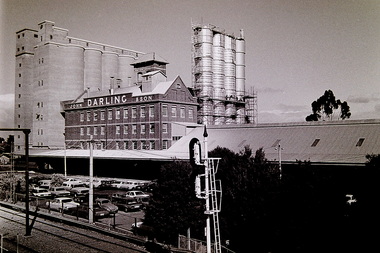 Sunshine and District Historical Society Incorporated
Photograph - John Darling And Sons Flour Mill Sydney Street Albion 1990 Photographs, Ken Irwin, 18th May 1990
... With the mill’s future uncertain, the site has been added to the Victoria's State Register of Historic Buildings....With the mill’s future uncertain, the site has been added to the Victoria's State Register of Historic Buildings. ...These photographs, taken by The Advocate newspaper in 1990, show the former John Darling & Son Flour Mill, now owned by Goodman Fielder, approximately twelve months after its closure. With the mill’s future uncertain, the site has been added to the Victoria's State Register of Historic Buildings.John Darling & Son Flour Mill in Albion is one of the most important industrial heritage sites in Melbourne’s west, a rare, largely intact example of a major early‑20th‑century roller flour mill, and a cornerstone of Sunshine’s transformation into a planned “garden industrial suburb.” These photographs capture the John Darling & Son Flour Mills when they had the stainless-steel silos which have been subsequently demolished. They also capture the Albion Railway Station and its carpark.John Darling Flour Mills Albion 36.1john darling and sons flour mill, flur mills, albion railway station, sydney street, albion, goodman fielder -
 Sunbury Family History and Heritage Society Inc.
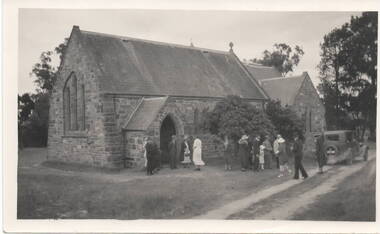
Photograph, c 1930s
... The original site has not been developed because some early graves are there....The original site has not been developed because some early graves are there. ...St. Mary's Anglican Church at Bulla originally occupied a site along Oaklands Road, adjacent to 'Woodlands' homestead. It was established in 1859. With the building of the Melbourne Airport at Tullamarine it was found that the church on its existing site was directly under the flight path and subject to possible damage from vibrations caused by the aircraft. As a result the historic building was demolished stone by stone and rebuilt in the Bulla township adjacent to the Alistair Clark Rose Garden. The original site has not been developed because some early graves are there.St. Mary's Church at Bulla is one of the earliest to be established in the Bulla district. Its mother church, St Pauls Church of England at the original Broadmeadows township was established in 1850 and it still stands and operates on its original site.A non-digital black and white photograph with a cream border of a stone church with the congregation members entering the church. A saloon car is parked near the church.st. mary's church of england, bulla., churches. -
Kew Historical Society Inc
Archive (Sub-series) - Subject File, Congregational Church (Walpole Street, Kew), 1958
... The file contains numerous original and copied primary sources as well as short histories and correspondence between the Kew Historical Society and the Historic Buildings Preservation Council when it was proposed to demolish the church. ...The file contains numerous original and copied primary sources as well as short histories and correspondence between the Kew Historical Society and the Historic Buildings Preservation Council when it was proposed to demolish the church. ...Various partiesReference, Research, InformationSecondary Values (KHS Imposed Order)Subject file containing information about the Congregational Church in Walpole Street, Kew (demolished 1979). The file contains numerous original and copied primary sources as well as short histories and correspondence between the Kew Historical Society and the Historic Buildings Preservation Council when it was proposed to demolish the church. Following the demolition of the Church, an aged care facility - Bodalla - was erected (since demolished). The file contains some information on Bodalla and a foundation stone relating to the former Church which was placed on the site. In the file, there is a photocopy of a brass plaque from 1860 that refers to the architect being George Wharton and the builders Messrs. Leach & Bicknell. congregational church -- kew (vic), churches -- kew (vic), walpole street -- kew (vic.)congregational church -- kew (vic), churches -- kew (vic), walpole street -- kew (vic.) -
 Sunshine and District Historical Society Incorporated
Archive - H.V McKay Bulk Store
... Newspaper Article Messenger 8 January 1998 titled Saved by change of heart|Newspaper Article The Advocate 29 July 1998 titled Eyesore or piece of history|Newspaper Article titled Bulk Store is meaningless Shirley A Strossa|Newspaper Article Advocate 22 July 1998 titled Bulk Store dissent|Petition Sunshine Harvester factory Buildings Form|Historic Building Act 1981 Permit 12470 Massey Ferguson Complex|Letter from Melbourne's Living Museum of the West Incorporated 5 January 1995 expressing objection to Mr Ray Tonkin Historic Buildings Council|Newspaper Article Sunshine Advocate 25 January 1995 titlled It's our heritage|Letter to Historic Buildings Council Hearing of Application 14 February 1995|Notes Submission to hearing of Historic Building Council on 14th February 1995|Notice informing public in 1995|Flyer titled Save Our Bulk Store Building|Flyer titled Why was saving the HV McKay Bulk Store|Flyer titled The Bulk Store must be saved|Written submissions on behalf of the applicant 12 April 1995|Newspaper Article Independent 25 April 1995 titled Demolition Bid|Historical Buildings Council 1994 to 1995 Annual Report|Newspaper Article Advocate 26 April 1995 titled Surprise Appeal Woolworths seeks nod to demolish buildings|Submission in the matter of the Historic Building Act 1981 and Burns Bridge Australia on behalf of Fabcot to demolish two brick buildings on the former Massey Ferguson site 12 April 1995|Letter to Historic Building Council 1 May 1995 S&DHS opposes the further application by Burns Bridge Australia for a permit to demolish two Sunshine Harvester Factory Building namely the bulk store and the electrical power house|Letter from Department of Planning and Development to Fabcot Pty Ltd 18 May 1995 regarding Massey Ferguson Complex Devonshire Road Sunshine encloses permit allowing the demoltition of the substation powerhouse building|Newspaper Article Brimbank Independent 23 May 1995 titled Compromise Breatkthrough for harvester site complex|Newspaper Article The Advocate 24 May 1995 titled Harvester building must be retained|Letter to Historic Buildings Council 24 August 1995 raising concerns|Newspaper Article The Times 30 August 1995 titled Woolworths unveils $70m Sunshine plan|Newspaper Article The Advocate 4 June 1997 titled Reaping the benefits|Letter to Heritage Victoria 23 September 1997 oppose Application from Amanda Johns of Minter Ellison for a permit to demolish the building|Letter from Melbourne's Living Museum of the West Incorporated 9 October 1997 expressing concern to S&DHS|Letter to Brimbank City Council 20th October 1997 S&DHS to draw certain matters to your attention|Newspaper Article The Advocate 29 October 1997 titled Renewed bid to Demolish Eyesore|Newspaper Article Brimbank Independent 4 November 1997 titled Fomer council blamed for McKay buildings disrepair The Sunshine factory was the birthplace of the basic award wage in Australia|Newspaper Article Brimbank Messenger 11 November 1997 titled Demolition threat on historic building|Newspaper Article Brimbank Independent 11 November 1997 titled Council waits for Heritage Victoria report before decision on Bulk Store threat|Newspaper Article The Age 13 November 1997 titled Past harvest of labor struggle and victory|Newspaper Article The Advocate 19 November 1997 titled Protecting our history|Letter from Adminstrative Appeals Tribunal 25 November 1997 advising hearing date|Letter to Adminstrative Appeals Tribunal 4 December 1997 Community & S&DHS objections to the demolition|Newspaper Article The Advocate 10 December 1997 titled Cinema Chaos|Newspaper Article The Age 15 December 1997 titled Rallying to maintain a little ray of Sunshine|Newspaper Article The Advocate 17 December 1997 titled Bulk Store Victory|Newspaper Article The Advocate 17 December 1997 titled McKay store fails to rate|Letter to Heritage Victoria from Beauchamp Consulting Engineers recommended repair method for the Former Massey Ferguson Bulk Store|Newspaper Article Brimbank Independent 17 February 1998 titled Bulk Store to be saved|Collection of documents of Gwen Goedecke regarding saving the Bulk Store|Advertising Melbourne's first 20 screen megaplex Village Cinemas|Blank Application to add building to the register of Historic buildings|Typed report from Beauchamp Consulting Engineers for Recommended Repair Method for Bulk Store|Typed report from Speroulla Christodoulou to Trades Hall Council regarding developer Woolworths want to demolish the Bulk Store building including all newspaper articles|Newspaper Article Brimbank Independent 26 January 1999 Funding Rejection for bulk store plans|Typed report The Story of How the Bulk Store was saved|Notice HV McKay Electrical Power House and Bulk Store|Typed report Why was saving the HV McKay Bulk Store so important?...McKays Sunshine Harvester Works Bulk Store Newspaper Article Messenger 8 January 1998 titled Saved by change of heart|Newspaper Article The Advocate 29 July 1998 titled Eyesore or piece of history|Newspaper Article titled Bulk Store is meaningless Shirley A Strossa|Newspaper Article Advocate 22 July 1998 titled Bulk Store dissent|Petition Sunshine Harvester factory Buildings Form|Historic Building Act 1981 Permit 12470 Massey Ferguson Complex|Letter from Melbourne's Living Museum of the West Incorporated 5 January 1995 expressing objection to Mr Ray Tonkin Historic Buildings Council|Newspaper Article Sunshine Advocate 25 January 1995 titlled It's our heritage|Letter to Historic Buildings Council Hearing of Application 14 February 1995|Notes Submission to hearing of Historic Building Council on 14th February 1995|Notice informing public in 1995|Flyer titled Save Our Bulk Store Building|Flyer titled Why was saving the HV McKay Bulk Store|Flyer titled The Bulk Store must be saved|Written submissions on behalf of the applicant 12 April 1995|Newspaper Article Independent 25 April 1995 titled Demolition Bid|Historical Buildings Council 1994 to 1995 Annual Report|Newspaper Article Advocate 26 April 1995 titled Surprise Appeal Woolworths seeks nod to demolish buildings|Submission in the matter of the Historic Building Act 1981 and Burns Bridge Australia on behalf of Fabcot to demolish two brick buildings on the former Massey Ferguson site 12 April 1995|Letter to Historic Building Council 1 May 1995 S&DHS opposes the further application by Burns Bridge Australia for a permit to demolish two Sunshine Harvester Factory Building namely the bulk store and the electrical power house|Letter from Department of Planning and Development to Fabcot Pty Ltd 18 May 1995 regarding Massey Ferguson Complex Devonshire Road Sunshine encloses permit allowing the demoltition of the substation powerhouse building|Newspaper Article Brimbank Independent 23 May 1995 titled Compromise Breatkthrough for harvester site complex|Newspaper Article The Advocate 24 May 1995 titled Harvester building must be retained|Letter to Historic Buildings Council 24 August 1995 raising concerns|Newspaper Article The Times 30 August 1995 titled Woolworths unveils $70m Sunshine plan|Newspaper Article The Advocate 4 June 1997 titled Reaping the benefits|Letter to Heritage Victoria 23 September 1997 oppose Application from Amanda Johns of Minter Ellison for a permit to demolish the building|Letter from Melbourne's Living Museum of the West Incorporated 9 October 1997 expressing concern to S&DHS|Letter to Brimbank City Council 20th October 1997 S&DHS to draw certain matters to your attention|Newspaper Article The Advocate 29 October 1997 titled Renewed bid to Demolish Eyesore|Newspaper Article Brimbank Independent 4 November 1997 titled Fomer council blamed for McKay buildings disrepair The Sunshine factory was the birthplace of the basic award wage in Australia|Newspaper Article Brimbank Messenger 11 November 1997 titled Demolition threat on historic building|Newspaper Article Brimbank Independent 11 November 1997 titled Council waits for Heritage Victoria report before decision on Bulk Store threat|Newspaper Article The Age 13 November 1997 titled Past harvest of labor struggle and victory|Newspaper Article The Advocate 19 November 1997 titled Protecting our history|Letter from Adminstrative Appeals Tribunal 25 November 1997 advising hearing date|Letter to Adminstrative Appeals Tribunal 4 December 1997 Community & S&DHS objections to the demolition|Newspaper Article The Advocate 10 December 1997 titled Cinema Chaos|Newspaper Article The Age 15 December 1997 titled Rallying to maintain a little ray of Sunshine|Newspaper Article The Advocate 17 December 1997 titled Bulk Store Victory|Newspaper Article The Advocate 17 December 1997 titled McKay store fails to rate|Letter to Heritage Victoria from Beauchamp Consulting Engineers recommended repair method for the Former Massey Ferguson Bulk Store|Newspaper Article Brimbank Independent 17 February 1998 titled Bulk Store to be saved|Collection of documents of Gwen Goedecke regarding saving the Bulk Store|Advertising Melbourne's first 20 screen megaplex Village Cinemas|Blank Application to add building to the register of Historic buildings|Typed report from Beauchamp Consulting Engineers for Recommended Repair Method for Bulk Store|Typed report from Speroulla Christodoulou to Trades Hall Council regarding developer Woolworths want to demolish the Bulk Store building including all newspaper articles|Newspaper Article Brimbank Independent 26 January 1999 Funding Rejection for bulk store plans|Typed report The Story of How the Bulk Store was saved|Notice HV McKay Electrical Power House and Bulk Store|Typed report Why was saving the HV McKay Bulk Store so important? ...Newspaper Article Messenger 8 January 1998 titled Saved by change of heart|Newspaper Article The Advocate 29 July 1998 titled Eyesore or piece of history|Newspaper Article titled Bulk Store is meaningless Shirley A Strossa|Newspaper Article Advocate 22 July 1998 titled Bulk Store dissent|Petition Sunshine Harvester factory Buildings Form|Historic Building Act 1981 Permit 12470 Massey Ferguson Complex|Letter from Melbourne's Living Museum of the West Incorporated 5 January 1995 expressing objection to Mr Ray Tonkin Historic Buildings Council|Newspaper Article Sunshine Advocate 25 January 1995 titlled It's our heritage|Letter to Historic Buildings Council Hearing of Application 14 February 1995|Notes Submission to hearing of Historic Building Council on 14th February 1995|Notice informing public in 1995|Flyer titled Save Our Bulk Store Building|Flyer titled Why was saving the HV McKay Bulk Store|Flyer titled The Bulk Store must be saved|Written submissions on behalf of the applicant 12 April 1995|Newspaper Article Independent 25 April 1995 titled Demolition Bid|Historical Buildings Council 1994 to 1995 Annual Report|Newspaper Article Advocate 26 April 1995 titled Surprise Appeal Woolworths seeks nod to demolish buildings|Submission in the matter of the Historic Building Act 1981 and Burns Bridge Australia on behalf of Fabcot to demolish two brick buildings on the former Massey Ferguson site 12 April 1995|Letter to Historic Building Council 1 May 1995 S&DHS opposes the further application by Burns Bridge Australia for a permit to demolish two Sunshine Harvester Factory Building namely the bulk store and the electrical power house|Letter from Department of Planning and Development to Fabcot Pty Ltd 18 May 1995 regarding Massey Ferguson Complex Devonshire Road Sunshine encloses permit allowing the demoltition of the substation powerhouse building|Newspaper Article Brimbank Independent 23 May 1995 titled Compromise Breatkthrough for harvester site complex|Newspaper Article The Advocate 24 May 1995 titled Harvester building must be retained|Letter to Historic Buildings Council 24 August 1995 raising concerns|Newspaper Article The Times 30 August 1995 titled Woolworths unveils $70m Sunshine plan|Newspaper Article The Advocate 4 June 1997 titled Reaping the benefits|Letter to Heritage Victoria 23 September 1997 oppose Application from Amanda Johns of Minter Ellison for a permit to demolish the building|Letter from Melbourne's Living Museum of the West Incorporated 9 October 1997 expressing concern to S&DHS|Letter to Brimbank City Council 20th October 1997 S&DHS to draw certain matters to your attention|Newspaper Article The Advocate 29 October 1997 titled Renewed bid to Demolish Eyesore|Newspaper Article Brimbank Independent 4 November 1997 titled Fomer council blamed for McKay buildings disrepair The Sunshine factory was the birthplace of the basic award wage in Australia|Newspaper Article Brimbank Messenger 11 November 1997 titled Demolition threat on historic building|Newspaper Article Brimbank Independent 11 November 1997 titled Council waits for Heritage Victoria report before decision on Bulk Store threat|Newspaper Article The Age 13 November 1997 titled Past harvest of labor struggle and victory|Newspaper Article The Advocate 19 November 1997 titled Protecting our history|Letter from Adminstrative Appeals Tribunal 25 November 1997 advising hearing date|Letter to Adminstrative Appeals Tribunal 4 December 1997 Community & S&DHS objections to the demolition|Newspaper Article The Advocate 10 December 1997 titled Cinema Chaos|Newspaper Article The Age 15 December 1997 titled Rallying to maintain a little ray of Sunshine|Newspaper Article The Advocate 17 December 1997 titled Bulk Store Victory|Newspaper Article The Advocate 17 December 1997 titled McKay store fails to rate|Letter to Heritage Victoria from Beauchamp Consulting Engineers recommended repair method for the Former Massey Ferguson Bulk Store|Newspaper Article Brimbank Independent 17 February 1998 titled Bulk Store to be saved|Collection of documents of Gwen Goedecke regarding saving the Bulk Store|Advertising Melbourne's first 20 screen megaplex Village Cinemas|Blank Application to add building to the register of Historic buildings|Typed report from Beauchamp Consulting Engineers for Recommended Repair Method for Bulk Store|Typed report from Speroulla Christodoulou to Trades Hall Council regarding developer Woolworths want to demolish the Bulk Store building including all newspaper articles|Newspaper Article Brimbank Independent 26 January 1999 Funding Rejection for bulk store plans|Typed report The Story of How the Bulk Store was saved|Notice HV McKay Electrical Power House and Bulk Store|Typed report Why was saving the HV McKay Bulk Store so important?|Letter to Brimbank City Council suggestion to use the Bulk Store as a youth centre|Letter to Norman Carlton at Sunshine and District Historical Society from Brimbank Council 8 September 2003|Letter from National Trust to Historical Buildings Council dated 5 March 1987|Report for submission in support of the Proposed demolition of Registered Historic Buildings for Former Bulk Store and Former Power Station Prepared for Burns Bridge Australia on behalf of Woolworths Pty Ltd|Letter to Heritage Victoria from Frank Ford dated 23 September 1997 pointing out structural reports and Brimbank Councils position and cultural significance of the Bulk Store Building|Handwritten Notes about Bulk Store 12 December 1997|Handwritten Notes about Bulk Store 15 December 1997|Handwritten Notes about Bulk Store 25 January 1998|Handwritten Notes about Bulk Store 29 January 1998|Various correspondence of City of Sunshine Councillors touring interstate for ideas of shopping mallsh.v. mckays, sunshine harvester works, bulk store -
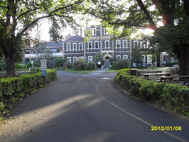 Vision Australia
Photograph - Image, St Kilda Road building in 2010, 6/1/2010
... In 2007, Vision Australia sold it's iconic 557-563 St Kilda Road site. The historic bluestone building was in need of renovation and repair, had limited space for staff and clients and with more demand for services in suburban and regional areas, did not meet the needs of the national organisation. ...Vision Australia 454 Glenferrie Road Kooyong melbourne In 2007, Vision Australia sold it's iconic 557-563 St Kilda Road site. The historic bluestone building was in need of renovation and repair, had limited space for staff and clients and with more demand for services in suburban and regional areas, did not meet the needs of the national organisation. ...In 2007, Vision Australia sold it's iconic 557-563 St Kilda Road site. The historic bluestone building was in need of renovation and repair, had limited space for staff and clients and with more demand for services in suburban and regional areas, did not meet the needs of the national organisation. The purchaser was mainly interested in the Ormond Hall section, which they sub-divided off and sold to the tenant of the Belgian Beer Cafe. The remainder of the site was then sold on to another developer. Unable to quickly proceed with their plans on developing the site for residential buildings, the site fell into some disrepair in the interim which was when these images were taken. Later the site was sold again and residential buildings now occupy part of the block. 20 images taken of and from St Kilda Road buildingroyal victorian institute for the blind, buildings, myer house, ferguson and urie -
Clunes Museum
Sign - DISPLAY PANEL, 2000
... THESE SCHOOLS WERE EASILY MOVED TO THE SITE OF THE LATEST GOLDRUSH. WITH GREATER COMMUNITY STABILITY PERMANENT SCHOOLS WERE ESTABLISHED. ...THESE SCHOOLS WERE EASILY MOVED TO THE SITE OF THE LATEST GOLDRUSH. WITH GREATER COMMUNITY STABILITY PERMANENT SCHOOLS WERE ESTABLISHED. ...COPIES OF DISPLAY PANELS DONATED TO THE PEOPLE OF CLUNES BY THE HUGH WILLIAMSON FOUNDATION.INTERPRETIVE DISPLAY PANEL DEPICTING HISTORY OF SCHOOL DAYS IN CLUNES. WOODEN DISPLAY PANEL AND LAMINATED COPY.SCHOOL DAYS CHILDREN OF EARLY GOLDFIELD TOWNS WERE TAUGHT IN TENT SCHOOLS. THESE SCHOOLS WERE EASILY MOVED TO THE SITE OF THE LATEST GOLDRUSH. WITH GREATER COMMUNITY STABILITY PERMANENT SCHOOLS WERE ESTABLISHED. CLUNES STATE SCHOOL NO. 1552 WAS OPENED IN JULY 1875 ON LAND DONATED BY RIVETT H. BLAND, MANAGER OF THE PORT PHILIP GOLD MINING CO. SHORTLY BEFORE WORLD WAR ONE, THIS SCHOOL BECAME VICTORIA'S THIRD HIGHER ELEMENTARY SCHOOL. TODAY IT IS STILL USED TO EDUCATE THE CHILDREN OF CLUNES STATE SCHOOL NO. 136 WAS BUILT IN 1881 ON THE SITE OF AN EARLIER TEMPORARY SCHOOL THAT WAS BUILT IN 1857. THE DESIGN WAS FIRST USED AT HORSHAM. AND INCLUDES AN EARLY EXAMPLE OF A LARGE SCHOOL VERANDAH. IN 1892 THIS SCHOOL AMALGAMATED WITH STATE SCHOOL NO. 1552 AND WAS USED AS THE INFANT SCHOOL. IT CLOSED ITS DOORS IN 1922 AND WAS LATER USED AS A MILL FOR THE CLUNES KNITTING AND MAUFACTURING CO. LTD. IT NOW HOUSES THE CLUNES BOTTLE MUSEUM THE CLUNES CATHOLIC SCHOOL OPENED IN 1875 AND CLOSED IN 1926 THE LATEST EDUCATIONAL ASSET AT CLUNES IS A CAMPUS OF WESLEY COLLEGE. BLENDING HISTORIC BUILDINGS AND MODERN ARCHITECTURE THE CAMPUS IS SITUATED IN SERVICE STREETlocal history, civic momentoes, presentations, williamson, hugh foundation -
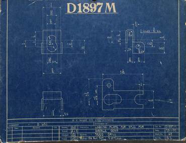 Sunshine and District Historical Society Incorporated
Archive - Sunshine Harvester Works H.V. McKay Massey Harris & Massey Ferguson - Miscelaneous Information
... Menhennitt 2693.15 - Russell Street Gates - Merv Brooks, John McIntyre & Roy Roberts 2693.16 - Massey Ferguson Historic Building Demolition Permit...McKay Massey Hassey Massey Ferguson - Alec Galbraith 43 Years Of Service Complimentary Dinner Menu 2693.07 - Sunshine Harvester Works - Museum Of Victoria Website Information 2693.08 - Massey Ferguson Site - City Of Sunshine Stimulating Sunshine's Local Economy Council's Purchase Of Massey Ferguson Site 2693.09 - Sunshine Harvester Works - Newspaper Articles 2693.10 - Braybrook Implement Works Testimonials 2693.11 - H.V. ...2693.01 - H.V. McKay - D1197M Locking Plate Blue Print 2693.02 - H.V. McKay - FDR92 Side Delivery Chute Blue Print 2693.03 - H.V. McKay - Russell Street Gates 2693.04 - H.V. McKay - Sunshine Harvester Website Launch 2001 2693.05 - H.V. McKay Massey Harris - Bert Ustick's Retirement Function Invitation To Ed Jenkins 2693.06 - H.V. McKay Massey Hassey Massey Ferguson - Alec Galbraith 43 Years Of Service Complimentary Dinner Menu 2693.07 - Sunshine Harvester Works - Museum Of Victoria Website Information 2693.08 - Massey Ferguson Site - City Of Sunshine Stimulating Sunshine's Local Economy Council's Purchase Of Massey Ferguson Site 2693.09 - Sunshine Harvester Works - Newspaper Articles 2693.10 - Braybrook Implement Works Testimonials 2693.11 - H.V. McKay Memorial Scholarship 2693.12 - Sunshine Harvester Factory - A History Of Sunshine Harvester 2693.13 - H.V. McKay Satellite Horse Hoes Or Scufflers 2693.14 - H.V. McKay Machinery By E. E. Wegener & H. Menhennitt 2693.15 - Russell Street Gates - Merv Brooks, John McIntyre & Roy Roberts 2693.16 - Massey Ferguson Historic Building Demolition Permith.v. mckays massey ferguson, sunshine harvester works -
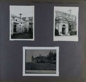 Glen Eira Historical Society
Album - Album page, Helenslea now Shelford CEGGS, Hood Crescent, Circa 1972
... The mansion has been the site of Shelford Church of England Girls’ Grammar School - now Shelford Girls’ Grammar School - since circa 1922....The mansion has been the site of Shelford Church of England Girls’ Grammar School - now Shelford Girls’ Grammar School - since circa 1922. ...This photograph is part of the Caulfield Historical Album 1972. This album was created in approximately 1972 as part of a project by the Caulfield Historical Society to assist in identifying buildings worthy of preservation. The album is related to a Survey the Caulfield Historical Society developed in collaboration with the National Trust of Australia (Victoria) and Caulfield City Council to identify historic buildings within the City of Caulfield that warranted the protection of a National Trust Classification. Principal photographer thought to be Trevor Hart, member of Caulfield Historical Society. Most photographs were taken between 1966-1972 with a small number of photographs being older and from unknown sources. All photographs are black and white except where stated, with 386 photographs over 198 pages. The mansion has been the site of Shelford Church of England Girls’ Grammar School - now Shelford Girls’ Grammar School - since circa 1922.From Victorian Heritage Database citation for HO115: "Helenslea" 3 Hood Crescent, Caulfield North https://vhd.heritagecouncil.vic.gov.au/places/35212 as at 21/10/2020 ''Helenslea'' was built for Sir George Stephen, MLA, barrister and mining investor by 1863. It was built with an address to Glen Eira Road with the driveway gates close by the present Helenslea Road corner. The present address is no. 3 Hood Crescent, Caulfield North. It is historically, aesthetically and socially significant. It is historically significant (Criterion A) as the home of Sir George Stephen, MLA for Collingwood, barrister and mining investor and for its capacity to demonstrate Caulfield's early attraction as a residential retreat for Melbourne's eminent citizens. It is aesthetically significant (Criterion E) as a villa residence characteristic of the mid Victorian period, predating the use of cast iron and comparing in this respect with Charles Webb's "Farleigh" (1865) at 6 Farleigh Grove, Brighton. Its substantial nature causes it to be the earliest surviving mansion house in the Municipality. The porch, external austerity and opulent entrance hall and staircase are important contributory elements whilst the survival of the exterior surfaces predominantly in an unpainted state enhances its level of integrity. It is socially significant (Criterion G) for its association with Shelford C.E.G.G.S. since 1922. Page 86 of Photograph Album with three photographs (two portrait and one landscape ) of different views of Helenslea. One is a photo of a photograph.Handwritten: "Helenslea" now C.E.G.G.S Hood Cres [top right] / third photo is of a photograph titled "Shelford" / 86 [bottom right]trevor hart, hood crescent, helenslea, c.e.g.g.s., school, 1860's, sir george stephen, unpainted, mansion, shelford, villa residence, mid victorian, glen eira road, helenslea road, ceggs, porches, stairs, caulfield north, entrances, shelford church of england girls' grammar school, shelford girl's grammar, ivy -covered walls, caulfield -
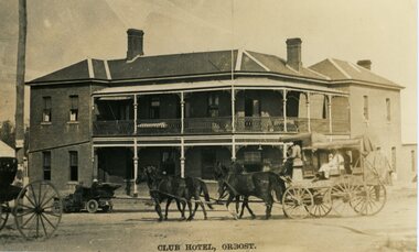 Orbost & District Historical Society
Photograph - postcard, Club Hotel, Orbost, c1920
... This photo is of the second building on the same site. In 2026, the Orbost Club Hotel still exists as the historic two storey building shown in this postcard....This photo is of the second building on the same site. In 2026, the Orbost Club Hotel still exists as the historic two storey building shown in this postcard. ...This is an old postcard with a photograph of the two-storey Club Hotel in Orbost, dated around 1920s (judging from the vehicles in the photo). The Club Hotel was one of the first buildings in early Orbost, with the earliest Hotel, built 1884, being a one-storey timber construction which no longer exists. This photo is of the second building on the same site. In 2026, the Orbost Club Hotel still exists as the historic two storey building shown in this postcard.This postcard is significant because it is a c.1920s photograph of the Club Hotel, Orbost, a building which still exists in Orbost.A b/w photo of a two-storey building with several chimneys - on a corner block. In the front is a 4 horse carriage with people sitting inside, and a motor vehicle. CLUB HOTEL, ORBOST orbost, hotel, club hotel -
 Eltham District Historical Society Inc
Slide, Joh Ebeli, The old Baker's house prior to demolition, corner of York Street and Main Road, Eltham, c.Sep. 1979
... The society had no official connection with any proposal to retain the building or any part of it on any other site. The issues involved were part of a wider consideration of the matter of preservation of historic buildings. ...The society had no official connection with any proposal to retain the building or any part of it on any other site. The issues involved were part of a wider consideration of the matter of preservation of historic buildings. ...Photo taken immediately prior to the demolition of the old baker's shop on the corner of Main Road and York Street, Eltham. Joh Ebeli and Elwers Howard endeavoured to preserve some parts of the house. The old weatherboard building, possibly dating from the 1860s, comprised a dwelling with a shop in the front room opening off a timber verandah deck which directly fronted the Main Road footpath. At the rear is a brick building of much later date which was for many years used for the bakery. The buildings were demolished for flat construction. Publicity at the time was oriented toward moves to preserve the weatherboard building which came from a number of individuals including members of this society. The society had no official connection with any proposal to retain the building or any part of it on any other site. The issues involved were part of a wider consideration of the matter of preservation of historic buildings. In this case the Society and in particular the committee had been aware for some years of the impending demolition. The possibility of the preservation of the building had been canvassed on a number of occasions. The Society’s view was that whilst the baker’s shop was an interesting old building which contributed to the character of Main Road, it was not of sufficient importance to wage an organised campaign for its preservation. It considered that if the building were to be preserved for historical reasons it would be far more feasible to retain it in its present location than to re-build it on another site.35 mm colour positive transparency Mount - Agfachrome Professional black (Germany) 4 dotsmain road, old eltham bakery, york street -
 Bendigo Historical Society Inc.
Newspaper - Fortuna Articles - "Fortuna part sale idea", Jan 24 2009
... historic mansion, ornamental lake, and mining battery. Non-heritage areas could be subdivided for private housing and possibly a health or aged-care facility. A new road connecting Marble and Chum streets could open up the site for these developments. The land west of the heritage lake and buildings...historic mansion, ornamental lake, and mining battery. Non-heritage areas could be subdivided for private housing and possibly a health or aged-care facility. A new road connecting Marble and Chum streets could open up the site for these developments. The land west of the heritage lake and buildings ...Steve Gibbons, Federal Member for Bendigo, suggests selling non-heritage parts of the Fortuna Villa property to fund maintenance of the historic mansion, ornamental lake, and mining battery. Non-heritage areas could be subdivided for private housing and possibly a health or aged-care facility. A new road connecting Marble and Chum streets could open up the site for these developments. The land west of the heritage lake and buildings is proposed for housing, while the corner of Chum and Booth streets is suggested for a health or aged-care facility. Gibbons emphasizes that only the original George Lansell property and its historic buildings are of heritage value; army-era buildings are not. He proposes that proceeds from development and ongoing rates be set aside to fund future maintenance of the heritage assets. Gibbons insists the mansion should remain in public ownership to preserve George Lansell's legacy and avoid burdening taxpayers or ratepayers. He is open to other ideas for the property's future use but stresses the need for a sustainable funding source. The City of Greater Bendigo is awaiting reports from the Department of Defence before making decisions about the property's future.Fortuna Article - "Fortuna part sale idea" Jan 24 2009 The Bendigo Advertiser by Sara Mennie This item contains the following: 11217.34a Colour Photo of Steve Gibbons, Federal Member for Bendigo 11217.34b Colour Photo of proposed extensions to the Fortuna site 11217.34c Part of Page 4 - Article "Fortuna part sale idea" 11217.34d Colour Photo of Front Page Photo from the Bendigo Advertiser showing Fortuna with a "For Sale Sign"non-fictionbendigo, fortuna, george lansell, steve gibbons -
 Sunshine and District Historical Society Incorporated
Article - Newpapers 1990's
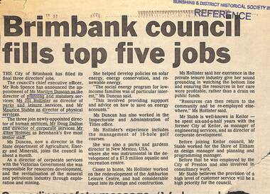
... 3831.01 - Newspaper Articles 1990's - Brimbank Council fills top five director jobs 3831.02 - Newspaper Articles 1990's - Australian Heritage Commission Arundel Rd Bridge & McKay Gardens Photo 01 3831.02 - Newspaper Articles 1990's - Australian Heritage Commission Arundel Rd Bridge & McKay Gardens Photo 02 3831.03 - Newspaper Articles 1990's - Albion Energy Park 3831.04 - Newspaper Articles 1990's - Council Money Crisis 3831.05 - Newspaper Articles 1990's - Sunshine City Band 60 Years Together 3831.06 - Newspaper Articles 1990's - Dr Patrick O'Brien retires 3831.07 - Newspaper Articles 1990's - Birth of a new nation 3831.08 - Newspaper Articles 1990's - Sunshine's historical heritage signs 3831.09 - Newspaper Articles 1990's - Rob Spence CEO plans no secrets council 3831.10 - Newspaper Articles 1990's - Sunshine Harvester Site Redevelopment 3831.11 - Newspaper Articles 1990's - Brimbank's Community Reference Panel 3831.12 - Newspaper Articles 1990's - New Sunshine Court House 3831.13 - Newspaper Articles 1990's - Rob Spence Council's Chief quits 3831.14 - Newspaper Articles 1990's - City Of Brimbank Commissioner Jan Nathan 3831.15 - Newspaper Articles 1990's - New Sunshine Police Office 3831.16 - Newspaper Articles 1990's - Havester Site Historic Buildings Appeal 3831.17 - Newspaper Articles 1990's - Brimbank a growing city CEO Rob Spence & Commissioner Jane Nathan 3831.18 - Newspaper Articles 1990's - Havester site purchased by Woolworths 3831.19 - Newspaper Articles 1990's - New Sunshine Megaplex Cinema Complex 3831.20 - Newspaper Articles 1990's - Sunshine Market Place opens 3831.21 - Newspaper Articles 1990's - Sunshine R.S.L. 75th anniversary 3831.22 - Newspaper Articles 1990's - Frank O'Connor 3831.23 - Newspaper Articles 1990's - Deer Park Foley family at Deer Park State School 3831.24 - Newspaper Articles 1990's - Historical signs 3831.25 - Newspaper Articles 1990's - Ballarat Rd Cnr Anderson Notice of Application for a Permit (Former Nettlefolds site) 3831.26 - Newspaper Articles 1990's - James 'Jim' Gaylor 3831.27 - Newspaper Articles 1990's - Donald 'Don' McKay's ashes scattered at H.V. ...3831.01 - Newspaper Articles 1990's - Brimbank Council fills top five director jobs 3831.02 - Newspaper Articles 1990's - Australian Heritage Commission Arundel Rd Bridge & McKay Gardens Photo 01 3831.02 - Newspaper Articles 1990's - Australian Heritage Commission Arundel Rd Bridge & McKay Gardens Photo 02 3831.03 - Newspaper Articles 1990's - Albion Energy Park 3831.04 - Newspaper Articles 1990's - Council Money Crisis 3831.05 - Newspaper Articles 1990's - Sunshine City Band 60 Years Together 3831.06 - Newspaper Articles 1990's - Dr Patrick O'Brien retires 3831.07 - Newspaper Articles 1990's - Birth of a new nation 3831.08 - Newspaper Articles 1990's - Sunshine's historical heritage signs 3831.09 - Newspaper Articles 1990's - Rob Spence CEO plans no secrets council 3831.10 - Newspaper Articles 1990's - Sunshine Harvester Site Redevelopment 3831.11 - Newspaper Articles 1990's - Brimbank's Community Reference Panel 3831.12 - Newspaper Articles 1990's - New Sunshine Court House 3831.13 - Newspaper Articles 1990's - Rob Spence Council's Chief quits 3831.14 - Newspaper Articles 1990's - City Of Brimbank Commissioner Jan Nathan 3831.15 - Newspaper Articles 1990's - New Sunshine Police Office 3831.16 - Newspaper Articles 1990's - Havester Site Historic Buildings Appeal 3831.17 - Newspaper Articles 1990's - Brimbank a growing city CEO Rob Spence & Commissioner Jane Nathan 3831.18 - Newspaper Articles 1990's - Havester site purchased by Woolworths 3831.19 - Newspaper Articles 1990's - New Sunshine Megaplex Cinema Complex 3831.20 - Newspaper Articles 1990's - Sunshine Market Place opens 3831.21 - Newspaper Articles 1990's - Sunshine R.S.L. 75th anniversary 3831.22 - Newspaper Articles 1990's - Frank O'Connor 3831.23 - Newspaper Articles 1990's - Deer Park Foley family at Deer Park State School 3831.24 - Newspaper Articles 1990's - Historical signs 3831.25 - Newspaper Articles 1990's - Ballarat Rd Cnr Anderson Notice of Application for a Permit (Former Nettlefolds site) 3831.26 - Newspaper Articles 1990's - James 'Jim' Gaylor 3831.27 - Newspaper Articles 1990's - Donald 'Don' McKay's ashes scattered at H.V. ...Large collection of various newpapers articles from the 1990's with many articles on Sunshine & District -
 Bendigo Historical Society Inc.
Slide - Adelaide Vale Homestead Fosterville
... [In Butcher & Flanders, Bendigo Historic Buildings, 1987, the date of the house is given as 1868. ...[In Butcher & Flanders, Bendigo Historic Buildings, 1987, the date of the house is given as 1868. ...Adelaide Vale Homestead was begun in 1853 by John Harvey and was later occupied by Edward and Andrew O'Keefe. The building comprises a series of single storey stone buildings arranged behind a simple composed, verandah facade with a centrally located doorway flanked by windows. A central corridor leads from this doorway to a transverse corridor which was probably once an open breezeway. A free- standing octagonal pavilion is located close to the house. This is an interesting homestead dating from early times and constructed of local stone. The front facade is typically composed and the plan reflects the continuous growth of the property throughout the nineteenth century. The octagonal pavillion is a significant and unusual feature. The homestead is picturesquely sited and overlooks the Campaspe River valley, the Burke and Wills expedition camped nearby on their ill-fated expedition north. The old cheese factory is the sole survivor of the once extensive out-buildings. Some of the nineteenth century buildings have been demolished and there have been some later additions and alterations, notably an extensive side wing added in the 1920's. [In Butcher & Flanders, Bendigo Historic Buildings, 1987, the date of the house is given as 1868. Presumably this house replaced an older one on the property.]Adelaide Vale Homestead Fostervillehistory, bendigo, national trust collection bendigo, adelaide vale homestead -
 Sunshine and District Historical Society Incorporated
Archive - HV McKay Electrical Power House and Bulk House
... Flyer HV McKay Electrical Power House and Bulk House|Extract Unveiling Memorial Plaque for Russell Street Gates 11 April 2000|Typed Notes Submission to hearing of Historic Buildings Countil on 14 February 1995 on Burns Bridge|Typed Letter 5 January 1995 Former Massey Ferguson Site Sunshine|Flyer Bulk Store and Electrical Power House|Typed Letter to The Chairman and Members Local Government Board Sustaining Local Government|Typed Letter to Minister for Planning the Honourable robert MacLellan Massey Ferguson Complex 4 October 1994|Newspaper Article Sunshine Advocate 23 August 1989 Australian Industry End of the Road|Newspaper Article 29 September 1928 Carnival Period ends today Saturday From Slab Smithy to Mammoth Factory|Newspaper Article The Age 13 November 1997 HV McKay Bulk Store Past Harvest of labor struggle and victory|Newspaper Article Advocate 9 September 1998 Few had all fingers|Newspaper Article Advocate 6 April 2004 HV McKay exhibit documents harvester manufacturing empire Museum honours Sunshine founder|Newspaper Article Advocate 27 January 2004 Box of treasures from firms past|Newspaper Article Sunshine Advocate Of the past in clean up|Newspaper Article The Advocate 13 December 1990 Sunshine farewells the place where it all began...McKays Sunshine Harvester Works Electricity' Flyer HV McKay Electrical Power House and Bulk House|Extract Unveiling Memorial Plaque for Russell Street Gates 11 April 2000|Typed Notes Submission to hearing of Historic Buildings Countil on 14 February 1995 on Burns Bridge|Typed Letter 5 January 1995 Former Massey Ferguson Site Sunshine|Flyer Bulk Store and Electrical Power House|Typed Letter to The Chairman and Members Local Government Board Sustaining Local Government|Typed Letter to Minister for Planning the Honourable robert MacLellan Massey Ferguson Complex 4 October 1994|Newspaper Article Sunshine Advocate 23 August 1989 Australian Industry End of the Road|Newspaper Article 29 September 1928 Carnival Period ends today Saturday From Slab Smithy to Mammoth Factory|Newspaper Article The Age 13 November 1997 HV McKay Bulk Store Past Harvest of labor struggle and victory|Newspaper Article Advocate 9 September 1998 Few had all fingers|Newspaper Article Advocate 6 April 2004 HV McKay exhibit documents harvester manufacturing empire Museum honours Sunshine founder|Newspaper Article Advocate 27 January 2004 Box of treasures from firms past|Newspaper Article Sunshine Advocate Of the past in clean up|Newspaper Article The Advocate 13 December 1990 Sunshine farewells the place where it all began HV McKay Electrical Power House and Bulk House Archive HV McKay Electrical Power House and Bulk House ...Flyer HV McKay Electrical Power House and Bulk House|Extract Unveiling Memorial Plaque for Russell Street Gates 11 April 2000|Typed Notes Submission to hearing of Historic Buildings Countil on 14 February 1995 on Burns Bridge|Typed Letter 5 January 1995 Former Massey Ferguson Site Sunshine|Flyer Bulk Store and Electrical Power House|Typed Letter to The Chairman and Members Local Government Board Sustaining Local Government|Typed Letter to Minister for Planning the Honourable robert MacLellan Massey Ferguson Complex 4 October 1994|Newspaper Article Sunshine Advocate 23 August 1989 Australian Industry End of the Road|Newspaper Article 29 September 1928 Carnival Period ends today Saturday From Slab Smithy to Mammoth Factory|Newspaper Article The Age 13 November 1997 HV McKay Bulk Store Past Harvest of labor struggle and victory|Newspaper Article Advocate 9 September 1998 Few had all fingers|Newspaper Article Advocate 6 April 2004 HV McKay exhibit documents harvester manufacturing empire Museum honours Sunshine founder|Newspaper Article Advocate 27 January 2004 Box of treasures from firms past|Newspaper Article Sunshine Advocate Of the past in clean up|Newspaper Article The Advocate 13 December 1990 Sunshine farewells the place where it all beganh.v. mckays, sunshine harvester works, electricity'