Showing 19 items matching "historic landscape image"
-
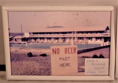 National Vietnam Veterans Museum (NVVM)
Photograph, 1968-1969 (Approximate)
... Historic landscape image...National Vietnam Veterans Museum (NVVM) 25 Veterans Drive Newhaven phillip-island-and-the-bass-coast Historic landscape image Photograph Vung Tau Peter Badcoe Club Vung Tau A Colour picture in white frame of a long house with a swimming pool at the front and a sign said "No beer past here" Photograph Photograph ...A Colour picture in white frame of a long house with a swimming pool at the front and a sign said "No beer past here"Peter Badcoe Club Vung Tauhistoric landscape image, photograph, vung tau -
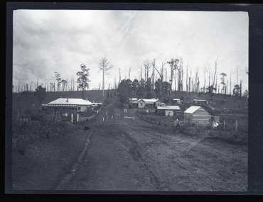 Emerald Museum & Nobelius Heritage Park
Negative - Image of Main Road, Gembrook, Baker & Rouse, Early 20th century
... images taken apparently around the same time at Gembrook c. early 20th century. This negative of the main road features two historic buildings, the Ranges Hotel and the General Store as well as a few houses and the railway station. The General Store was built in front of the railway station. This negative shows former iconic and historical buildings in Gembrook. Gembrook Ranges Hotel Ferntree Gully to Gembrook Railway General Store Main Road early 20th century Handwritten on (not original) packet containing negative: 'Gembrook township' Black and white negative - landscape ...This negative is one of a batch of ten images taken apparently around the same time at Gembrook c. early 20th century. This negative of the main road features two historic buildings, the Ranges Hotel and the General Store as well as a few houses and the railway station. The General Store was built in front of the railway station.This negative shows former iconic and historical buildings in Gembrook.Black and white negative - landscape view - showing the main road in Gembrook heading west. The last building on the left is the Ranges Hotel and the second last building on the right is the double-gabled General Store which fronts the railway station. This negative has been kept inside a packet which is not original.Handwritten on (not original) packet containing negative: 'Gembrook township'gembrook, ranges hotel, ferntree gully to gembrook railway, general store, main road, early 20th century -
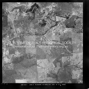 Eltham District Historical Society Inc
Photograph - Aerial Photograph, Landata, Eltham / Research, Vic, Jan. 1951
... Historic Aerial Imagery Source: Landata.vic.gov.au Aerial Photo Details: Project No :65 Project : MELBOURNE AND METROPOLITAN PROJECT NO. 2 Run : 7 Frame : 8 Date : 01/1951 Film Type : B/W Camera : EAG9 Flying Height : 12200 Scale : 12000 Film Number : 1419 GDA2020 : 37°42'32"S, 145°10'41"E MGA2020 : 339408, 5824924 (55) Melways : 22 F3 (ed. 42) Historical aerial photos and photo maps provide viusal evidence of the chronology of changes to the built landscape of the district and assist in dating other images Aerial Photo 1951-01 Eltham Neil Webster Collection Brinkkotter Road Eltham College Leane Drive Maroondah Aqueduct Melways 22F3 Nyora Road Yarramie Reserve Digital jpg and electronic PDF file Eltham / Research, Vic. ...Centred on Brinkkotter Road opposite Yarramie Reserve, Eltham bounded by Maroondah Aqueduct to north, Nyora Road to south, Eltham College to east and Leane Drive to west. Historic Aerial Imagery Source: Landata.vic.gov.au Aerial Photo Details: Project No :65 Project : MELBOURNE AND METROPOLITAN PROJECT NO. 2 Run : 7 Frame : 8 Date : 01/1951 Film Type : B/W Camera : EAG9 Flying Height : 12200 Scale : 12000 Film Number : 1419 GDA2020 : 37°42'32"S, 145°10'41"E MGA2020 : 339408, 5824924 (55) Melways : 22 F3 (ed. 42)Historical aerial photos and photo maps provide viusal evidence of the chronology of changes to the built landscape of the district and assist in dating other imagesaerial photo, 1951-01, eltham, neil webster collection, brinkkotter road, eltham college, leane drive, maroondah aqueduct, melways 22f3, nyora road, yarramie reserve -
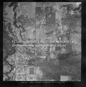 Eltham District Historical Society Inc
Photograph - Aerial Photograph, Landata, Eltham, Vic, Jan. 1951
... Historic Aerial Imagery Source: Landata.vic.gov.au Aerial Photo Details: Project No :65 Project : MELBOURNE AND METROPOLITAN PROJECT NO. 2 Run : 7 Frame : 9 Date : 01/1951 Film Type : B/W Camera : EAG9 Flying Height : 12200 Scale : 12000 Film Number : 1419 GDA2020 : 37°42'23"S, 145°09'39"E MGA2020 : 337874, 5825170 (55) Melways : 22 B3 (ed. 42) Historical aerial photos and photo maps provide viusal evidence of the chronology of changes to the built landscape of the district and assist in dating other images Aerial Photo 1951-01 Eltham Neil Webster Collection Arthur Street Beard Street Catholic Ladies College frank street Main Road Maroondah Aqueduct Maroong Drive Melway 22B3 Research (Vic.) ...Centred on Beard Street between Main Road and Frank Street, Eltham bounded by Maroondah Aqueduct to north, Arthur Street to south, Maroong Drive to east and Catholic Ladies College to west. Historic Aerial Imagery Source: Landata.vic.gov.au Aerial Photo Details: Project No :65 Project : MELBOURNE AND METROPOLITAN PROJECT NO. 2 Run : 7 Frame : 9 Date : 01/1951 Film Type : B/W Camera : EAG9 Flying Height : 12200 Scale : 12000 Film Number : 1419 GDA2020 : 37°42'23"S, 145°09'39"E MGA2020 : 337874, 5825170 (55) Melways : 22 B3 (ed. 42)Historical aerial photos and photo maps provide viusal evidence of the chronology of changes to the built landscape of the district and assist in dating other imagesaerial photo, 1951-01, eltham, neil webster collection, arthur street, beard street, catholic ladies college, frank street, main road, maroondah aqueduct, maroong drive, melway 22b3, research (vic.) -
 Eltham District Historical Society Inc
Photograph - Aerial Photograph, Landata, Eltham, Vic, Jan. 1951
... Historic Aerial Imagery Source: Landata.vic.gov.au Aerial Photo Details: Project No :65 Project : MELBOURNE AND METROPOLITAN PROJECT NO. 2 Run : 7 Frame : 10 Date : 01/1951 Film Type : B/W Camera : EAG9 Flying Height : 12200 Scale : 12000 Film Number : 1419 GDA2020 : 37°42'14"S, 145°08'36"E MGA2020 : 336339, 5825416 (55) Melways : 21 H2 (ed. 42) Historical aerial photos and photo maps provide viusal evidence of the chronology of changes to the built landscape of the district and assist in dating other images Aerial Photo 1951-01 Eltham Neil Webster Collection Allendale Road Allison Crecent Reserve Dudley Street Melway 21H2 Scenic Crescent Sherbrook Road St Helena Road Zig Zag Road Digital jpg and electronic PDF file Eltham, Vic. ...Centred on Allison Crecent Reserve, Sherbrook Road and Scenic Crescent, Eltham bounded by Allendale Road to north, Dudley Street to south, Zig Zag Road to east and St Helena Road to west. Historic Aerial Imagery Source: Landata.vic.gov.au Aerial Photo Details: Project No :65 Project : MELBOURNE AND METROPOLITAN PROJECT NO. 2 Run : 7 Frame : 10 Date : 01/1951 Film Type : B/W Camera : EAG9 Flying Height : 12200 Scale : 12000 Film Number : 1419 GDA2020 : 37°42'14"S, 145°08'36"E MGA2020 : 336339, 5825416 (55) Melways : 21 H2 (ed. 42)Historical aerial photos and photo maps provide viusal evidence of the chronology of changes to the built landscape of the district and assist in dating other imagesaerial photo, 1951-01, eltham, neil webster collection, allendale road, allison crecent reserve, dudley street, melway 21h2, scenic crescent, sherbrook road, st helena road, zig zag road -
 The Beechworth Burke Museum
Photograph, 1920-1950
... This image of hydraulic sluicing methods shows the extent of water-works engineering in the landscape. This photograph has historic and research potential for understanding changes to the landscape, the evolution of mining methods, and the extensive construction, manipulation and management of water networks in the Beechworth district. burke museum beechworth museum beechworth gold fields gold rush victorian gold rush hydraulic sluicing spring creek netwown falls mining tunnels water races tailraces gold ming history colonial australia australian gold rushes mining technology beechworth historic district indigo gold trail indigo shire john pund water manipulation water engineering three mile creek three mile mine water race large-scale mining methods historical mining construction alluvial mining mining environmental impacts baarmutha water barons Reverse: 7597-1 / Sluice Mining / Copied from original on loan from Webb (Qld) / Donated Nov 2009 / Baarmutha Three Mile Mine c1920-1950 / Managed by the Plain Bros then Parkinsons / Current Location is: Beechworth Animal Shelter / used for Baarmutha Black and white rectangular photograph on matte paper Photograph Photograph ...This image taken between 1920-1930 depicts open-cut hydraulic sluicing at the Three Mile Mine, located about five kilometres south of Beechworth. Alluvial, or surface, mining began on this site in the 1850s, but was soon replaced by hydraulic sluicing methods. By the start of 1880 it is estimated that nine hundred miles of water races had been cut though soil and rock in the Beechworth district. Hydraulic sluicing employs high pressure jets of water to blast away large areas of earth and wash it down to be run through a sluice box. Gold gets caught in the sluice and the remaining slurry is washed away. Large water quantities were required for hydraulic sluicing, and the long water races and deep tailraces that were constructed were considered great engineering feats. This method of mining is extremely effective, but causes significant environmental damage and impacts to waterways and agricultural operations. Miners at Beechworth built extensive networks of races and dams to secure reliable supplies of water on a scale far greater than elsewhere in Victoria. By the 1880s Beechworth's water barons continued to hold more than half of all the water right licences on issue and undertook sluicing operations on a massive scale. The manipulation of surface and ground water via race networks was well planned and recorded in detail by local mining surveyors. The maps that were created, combined with modern geo-spatial technologies, provide a vital key in understanding the great lengths to which miners went to capture and control critical water resources. Today, Three Mile mine is called Baarmutha. The Three Mile Mine was unproductive until 1865 when John Pund and three other miners secured a fifteen year license and constructed a water race from Upper Nine Mile Creek to Three Mile Creek. In the early twentieth century Pund & Co. averaged over one thousand ounces of gold per year from the mine. After Pund's death in 1915, GSG Amalgamated Co operated the site, continuing sluicing until 1950. This image of hydraulic sluicing methods shows the extent of water-works engineering in the landscape. This photograph has historic and research potential for understanding changes to the landscape, the evolution of mining methods, and the extensive construction, manipulation and management of water networks in the Beechworth district. Black and white rectangular photograph on matte paperReverse: 7597-1 / Sluice Mining / Copied from original on loan from Webb (Qld) / Donated Nov 2009 / Baarmutha Three Mile Mine c1920-1950 / Managed by the Plain Bros then Parkinsons / Current Location is: Beechworth Animal Shelter / used for Baarmuthaburke museum, beechworth museum, beechworth, gold fields, gold rush, victorian gold rush, hydraulic sluicing, spring creek, netwown falls, mining tunnels, water races, tailraces, gold ming history, colonial australia, australian gold rushes, mining technology, beechworth historic district, indigo gold trail, indigo shire, john pund, water manipulation, water engineering, three mile creek, three mile mine, water race, large-scale mining methods, historical mining construction, alluvial mining, mining environmental impacts, baarmutha, water barons -
 Bay Steamers Maritime Museum
Framed Painting, S. T. Wattle, 1998
... This painting shows that Wattle was appreciated as a historic vessel, a fun mode of transportation and that there was some appeal to seeing images in her likeness such as this painting. oil painting passenger vessel tourists wattle painting bay steamers maritime museum port phillip bay The painting is signed in the bottom right hand corner " '98 David Carden" Oil painting of the Steam Tug Wattle after conversion to a passenger-carrying vessel.The port side of the ship is shown in an open water landscape, and is moving towards the left hand edge of the frame S. ...This is an oil painting of the Steam Tug Wattle after conversion to a passenger carrying vessel. She was a popular tourist outing for people in the Port Philip Bay area. This painting shows that Wattle was appreciated as a historic vessel, a fun mode of transportation and that there was some appeal to seeing images in her likeness such as this painting.Oil painting of the Steam Tug Wattle after conversion to a passenger-carrying vessel.The port side of the ship is shown in an open water landscape, and is moving towards the left hand edge of the frame The painting is signed in the bottom right hand corner " '98 David Carden"oil painting, passenger vessel, tourists, wattle, painting, bay steamers maritime museum, port phillip bay -
 Glenelg Shire Council Cultural Collection
Work on paper - Watercolour, Florence Tatham Mellblom, Portland Shire Hall, n.d
... image lower left, 63.5 x 101.5 cm. Linen-backed. Text continues in lower margin: 'Arbuckle, Waddell Pty Ltd Print, Melb.', Mellblom (nee Henry) was a painter, naturalist and photographer. She was born at Portland, Victoria, and studied art in Ballarat. She was a talented etcher from childhood, and joined the Portland Camera club. She also produced many watercolour paintings of the historic places of Portland. She was married (1932) to Karl Enoch Mellblom. Female Artist Women Female Landscape ...From Antiques Reporter: Florence Tatham Mellblom, (Australian, 1900 - 1983), Visit Portland The First Victorian Settlement, during the Centenary Celebrations from 15th to 23rd November 1934', 1934 colour lithograph, signed 'F. Mellblom' in image lower left, 63.5 x 101.5 cm. Linen-backed. Text continues in lower margin: 'Arbuckle, Waddell Pty Ltd Print, Melb.', Mellblom (nee Henry) was a painter, naturalist and photographer. She was born at Portland, Victoria, and studied art in Ballarat. She was a talented etcher from childhood, and joined the Portland Camera club. She also produced many watercolour paintings of the historic places of Portland. She was married (1932) to Karl Enoch Mellblom.A bluestone building on an arid landscape. Yellow grass in the foreground with one tree standing at the front. There is a blue sky behind. The left hand wing has a door which is slightly open. Above each wing is an engraved piece of stone. Left - Portland, right - Shire. An old rickety fence to the left of the building.Bottom Right - F. Mellblomfemale artist, women, female, landscape, portland landscape, portland shire -
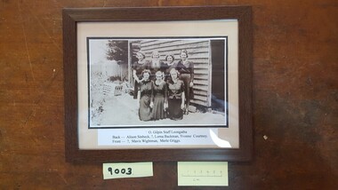 Coal Creek Community Park & Museum
Photograph - O. Gilpin Store Staff, Leongatha, c.1940
... historic record Gilpin store Female staff Leongatha 1940s workers Alison Sinbeck Lorna Backman Yvonne Courtney Mavis Wightman Merle Griggs O. Gilpin Staff Leongatha / Back - Alison Sinnbeck,?, Lorna Backman, Yvonne Courtney. / Front - ?, Mavis Wightman, Merle Griggs. Dark wooden-framed rectangular photograph with glass, mounted with cream and black matt board. Landscape-oriented black + white image ...Dark wooden-framed rectangular photograph with glass, mounted with cream and black matt board. Landscape-oriented black + white image representing seven women in front of rustic weatherboard building.O. Gilpin Staff Leongatha / Back - Alison Sinnbeck,?, Lorna Backman, Yvonne Courtney. / Front - ?, Mavis Wightman, Merle Griggs.historic record, gilpin store, female staff, leongatha, 1940s, workers, alison sinbeck, lorna backman, yvonne courtney, mavis wightman, merle griggs -
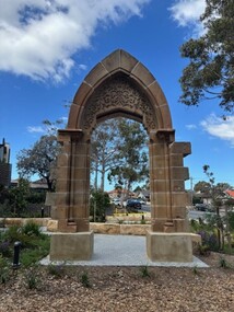 Vision Australia
Photograph - Image, Denise Pellow, Archway at Enfield, 2025
... The developers of the site recognised that it was part of the historic fabric of Sydney however, and placed it within the landscaped front entrance to the site. Sydney Industrial Blind Institution Buildings Royal Blind Society of NSW Edmund Blacket 10 digital images of stone archway Archway at Enfield Photograph Image Denise Pellow ...In 1878 Sydney Industrial Blind Institution was built on the corner of Boomerang and William Streets in Sydney. Designed by Edmund Blacket, it was intended to be a workshop, showroom for items produced there and accomodate 10-12 people to live on the premises. The three story building (and subsequent extensions) ended up being used up until 1971, when the need for more space and the limitations of city buildings necessitated the move to Enfield. As part of this transition, and due to the demolition of the old building, a stone archway was removed in 1971 and relocated to the new RBS offices in Mitchell Street. Almost half a century later, that site was sold however the archway could not be moved to the various commercial offices that now housed staff. City of Sydney council did not have a suitable location, as the original site was now a private housing complex, NSW Dept of Heritage did not preserve parts of buildings and it was not from a building originally located within the boundaries of the Burwood Council. The developers of the site recognised that it was part of the historic fabric of Sydney however, and placed it within the landscaped front entrance to the site.10 digital images of stone archwaysydney industrial blind institution, buildings, royal blind society of nsw, edmund blacket -
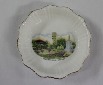 Wodonga & District Historical Society Inc
Memorabilia - China Souvenir Bowl Woodland Grove Wodonga, c. 1920 - 1940
... historic and social significance as it depicts which features of the city the community valued in the past. It has artistic significance as an example of the kinds of souvenirs used widely across Australia to represent communities and the landscape. wodonga souvenirs woodland grove ceramics Beneath the painted central image "WOODLAND GROVE, WODONGA A white glazed china souvenir bowl. ...A wide range of small china pieces carrying scenic views of holiday destinations or key locations were a popular kind of souvenir during much of the 20th century. Several different items have been produced to commemorate Wodonga and its landmarks over time. These items document key changes in Wodonga and its heritage. This plate depicts three key landmarks in Wodonga. THE SOLDIERS' MEMORIAL in Wodonga was unveiled on Tuesday 18th November 1924. It was designed by Messrs. Hosken & Co., of Hawthorn, Victoria. The monument is all of Australian workmanship. The pedestal is made of Harcourt granite, 9ft x 9ft at the base, and rising in seven courses to a height of 10ft 2in. The emblems (rising sun and wreath) are of bronze, and the lettering of the inscription and names of fallen soldiers are in raised lead letters. Originally the Memorial was completed with a full life size, 6ft in height, sculpture of an Australian soldier in Sicilian marble. The memorial bore the inscriptions: ERECTED BY THE RESIDENTS OF WODONGA AND DISTRICT IN MEMORY of the Men of this Town and District who fell in the Great War, 1914-1919, Also in grateful recognition of the men who served and returned. “Lest We Forget.” In 1982, due to frequent vandalism and high cost of materials to repair, the soldier statue was removed and later installed at the RSL Rooms. THE WATER TOWER is a major landmark of High Street, Wodonga. It began operation from 1924 until it ceased operation in 1959. It stood unused for a decade until the lower section was modified and put to use as “ The Tower’s Cobbler’s Inn” in 1962. In 1972 Wodonga City Council proposed to demolish the Tower. Their suggestion received an unfavorable response from the city’s citizens, so the Tower still stands today. THE BAND ROTUNDA was officially opened on Sunday 5th September 1920 at the naming of the triangular reserve at the corner of High and Hovell Streets as Woodland Grove. The Wodonga Band gave a public performance on this occasion. The tri-coloured ribbon, which stretched across the entrance to the Rotunda was cut by Mrs R.H Murphy, daughter of Mr. John Woodland, secretary of the Wodonga Shire Council for 35 years, after whom the area was named. The rotunda has since been moved to Martin Park, Wodonga. This item has local historic and social significance as it depicts which features of the city the community valued in the past. It has artistic significance as an example of the kinds of souvenirs used widely across Australia to represent communities and the landscape.A white glazed china souvenir bowl. Frilled edge. Includes a painted representation of Woodland Grove, Wodonga, VictoriaBeneath the painted central image "WOODLAND GROVE, WODONGAwodonga, souvenirs, woodland grove, ceramics -
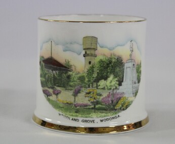 Wodonga & District Historical Society Inc
Memorabilia - China Souvenir Cup Woodland Grove Wodonga, c. 1925 - 1940
... historic and social significance as it depicts which features of the city the community valued in the past. It has artistic significance as an example of the kinds of souvenirs used widely across Australia to represent communities and the landscape. souvenirs wodonga woodland grove soldiers memorial wodonga landmarks "WOODLAND GROVE, WODONGA." A white souvenir cup made from china with a water colour image ...A wide range of small china pieces carrying scenic views of holiday destinations or key locations were a popular kind of souvenir during much of the 20th century. Several different items have been produced to commemorate Wodonga and its landmarks over time. These items document key changes in Wodonga and its heritage. This cup depicts three key landmarks in Wodonga. THE SOLDIERS' MEMORIAL in Wodonga was unveiled on Tuesday 18th November 1924. It was designed by Messrs. Hosken & Co., of Hawthorn, Victoria. The monument is all of Australian workmanship. The pedestal is made of Harcourt granite, 9ft x 9ft at the base, and rising in seven courses to a height of 10ft 2in. The emblems (rising sun and wreath) are of bronze, and the lettering of the inscription and names of fallen soldiers are in raised lead letters. Originally the Memorial was completed with a full life size, 6ft in height, sculpture of an Australian soldier in Sicilian marble. The memorial bore the inscriptions: ERECTED BY THE RESIDENTS OF WODONGA AND DISTRICT IN MEMORY of the Men of this Town and District who fell in the Great War, 1914-1919, Also in grateful recognition of the men who served and returned. “Lest We Forget.” In 1982, due to frequent vandalism and high cost of materials to repair, the soldier statue was removed and later installed at the RSL Rooms. THE WATER TOWER is a major landmark of High Street, Wodonga. It began operation from 1924 until it ceased operation in 1959. It stood unused for a decade until the lower section was modified and put to use as “ The Tower’s Cobbler’s Inn” in 1962. In 1972 Wodonga City Council proposed to demolish the Tower. Their suggestion received an unfavorable response from the city’s citizens, so the Tower still stands today. THE BAND ROTUNDA was officially opened on Sunday 5th September 1920 at the naming of the triangular reserve at the corner of High and Hovell Streets as Woodland Grove. The Wodonga Band gave a public performance on this occasion. The tri-coloured ribbon, which stretched across the entrance to the Rotunda was cut by Mrs R.H Murphy, daughter of Mr. John Woodland, secretary of the Wodonga Shire Council for 35 years, after whom the area was named. The rotunda has since been moved to Martin Park, Wodonga. This item has local historic and social significance as it depicts which features of the city the community valued in the past. It has artistic significance as an example of the kinds of souvenirs used widely across Australia to represent communities and the landscape.A white souvenir cup made from china with a water colour image of Woodland Grove, Wodonga which incorporates the Soldier Memorial, Water Tower and the Rotunda."WOODLAND GROVE, WODONGA."souvenirs, wodonga, woodland grove, soldiers memorial, wodonga landmarks -
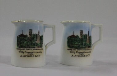 Wodonga & District Historical Society Inc
Memorabilia - China Souvenir Jugs Woodland Grove Wodonga, c. 1940
... historic and social significance as it depicts which features of the city the community valued in the past. It has artistic significance as an example of the kinds of souvenirs used widely across Australia to represent communities and the landscape. wodonga souvenirs woodland grove ceramics arnolds wodonga Beneath the image : "WOODLAND GROVE, VIC. / With Compliments/ from/ A. ...A wide range of small china pieces carrying scenic views of holiday destinations or key locations were a popular kind of souvenir during much of the 20th century. Several different pieces were used to depict Wodonga during this period, primarily focusing on the Woodland Grove and the Soldier Memorial. In 1924, Arthur Arnold and his father Wilhelm Arnold had established a general store in High Street, near the water tower, but in 1931–32 they moved to new premises in High Street on the corner of what is now known as Elgin Boulevard. In 1933-34 they widened the frontage of the shop and added new premises at the rear for the sale of produce. As customer debt mounted during the depression, it became difficult for Arthur and Wilhelm to re-stock the shop, so they enticed customers into paying their accounts by rewarding them with a small individual cream or milk jug upon payment. The jugs were made in Czechoslovakia and displayed the war memorial, water tower and bandstand from Woodland Grove, Wodonga. The Arnolds continued to trade until they finally closed their store in 1950. Wilhelm Arnold was a brother of J G Arnold, whose business ultimately became the present-day Arnold’s Fruit Market, Wodonga. This item has local historic and social significance as it depicts which features of the city the community valued in the past. It has artistic significance as an example of the kinds of souvenirs used widely across Australia to represent communities and the landscape.A pair of miniature white jugs with a gold rim and handle detailing. A hand-coloured transfer image fills the front side depicts Woodland Grove Wodonga, including the Soldiers' Memorial, Water Tower and RotundaBeneath the image : "WOODLAND GROVE, VIC. / With Compliments/ from/ A. Arnold & Co."wodonga, souvenirs, woodland grove, ceramics, arnolds wodonga -
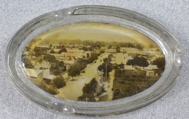 Wodonga & District Historical Society Inc
Memorabilia - Souvenir Glass Ashtray Wodonga, Victoria
... historic and social significance as it depicts which features of the city the community valued in the past. It has artistic significance as an example of the kinds of souvenirs used widely across Australia to represent communities and the landscape. wodonga victoria souvenir high street wodonga ash trays An oval shaped glass ashtray, incorporating a sepia print image of High Street, Wodonga, Victoria Souvenir Glass Ashtray Wodonga, Victoria Memorabilia Souvenir Glass Ashtray Wodonga, Victoria ...A wide range of small china or glass pieces carrying scenic views of holiday destinations or key locations were a popular kind of souvenir during much of the 20th century. Several different items have been produced to commemorate Wodonga and its landmarks over time. These items document key changes in Wodonga and its heritage. This ashtray showcases a photo of High Street, Wodonga, VictoriaThis item has local historic and social significance as it depicts which features of the city the community valued in the past. It has artistic significance as an example of the kinds of souvenirs used widely across Australia to represent communities and the landscape.An oval shaped glass ashtray, incorporating a sepia print image of High Street, Wodonga, Victoriawodonga victoria, souvenir, high street wodonga, ash trays -
 Clunes Museum
Film - DVD, Nine Network Australia, Postcards - Episode 22, 2008, 2008
... Images of significant sites and historic buildings as well as streetscapes and landscapes of Clunes....Images of significant sites and historic buildings as well as streetscapes and landscapes of Clunes. ...Visual programme featuring Widow Twankey's. a local cafe, and the Clunes Museum prior to the redevelopment of the site at 36 Fraser Street, in 2012. Interviews of Tim Hayes, owner of Widow Twankey's and Pat Cook the Curator of Clunes Museum. Images of significant sites and historic buildings as well as streetscapes and landscapes of Clunes.DVD IN WHITE PAPER SLEEVE CHANNFEL 9 POSTCARDS, EPISODE 22 "GENERAL SHOW"widow twankey's, pat cook, tim hayes, clunes museum -
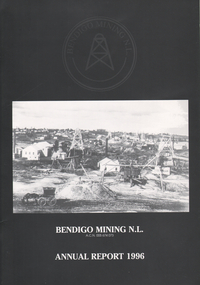 Bendigo Historical Society Inc.
Booklet - Bendigo Mining N.L. Annual Report 1996, 1996
... image of early Bendigo mine landscape. Written on front cover: 'Bendigo Mining N.L. Annual Report 1996' Twenty eight page booklet, with maps of tenement areas and exploration projects; reserve and resource ounces; longitudinal project Deborah line of reef; historic production 1931 - 1954 Deborah line of reef; Williams United Gold Project; Williams United Surface Plan; Birds/South Carshalton Gold project and financial reports. ...image of early Bendigo mine landscape. Written on front cover: 'Bendigo Mining N.L. Annual Report 1996' Twenty eight page booklet, with maps of tenement areas and exploration projects; reserve and resource ounces; longitudinal project Deborah line of reef; historic production 1931 - 1954 Deborah line of reef; Williams United Gold Project; Williams United Surface Plan; Birds/South Carshalton Gold project and financial reports. ...Black cover with image of early Bendigo mine landscape. Written on front cover: 'Bendigo Mining N.L. Annual Report 1996' Twenty eight page booklet, with maps of tenement areas and exploration projects; reserve and resource ounces; longitudinal project Deborah line of reef; historic production 1931 - 1954 Deborah line of reef; Williams United Gold Project; Williams United Surface Plan; Birds/South Carshalton Gold project and financial reports. bendigo mining n.l., deborah line of reef, williams united gold project, williams united surface plan, birds/south carshalton gold project -
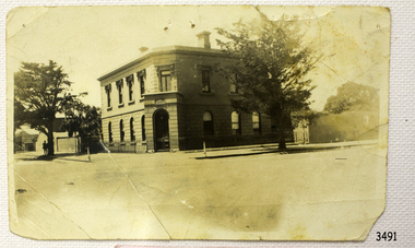 Flagstaff Hill Maritime Museum and Village
Photograph - Building, Bank of Australasia Warrnambool, ca. 1860
... historic building Roberts & Co. James Cust bank of australasia warrnambool Label with: "AH2 2 / W.BOOL" Writing in pen: "D. K. Frew / --- / ---- / ----" Black and white (or sepia) rectangular photograph, landscape orientation. Image ...This sepia coloured photograph show the image of the former Bank of Australasia in Warrnambool. The two-storey building was built for the bank on the corner of Timor and Kepler Streets and opened there for business in 1860. It is now one of the City's Historic Buildings. The Bank of Australasia was incorporated by Royal Charter of England in March 1834. It came to Australia on 14th December 1835, opening in Sydney. The Acting Superintendent of the Bank of Australasia in Sydney at that time was David Charters McArthur. He was Superintendent from 1867-to 1876. The Melbourne branch of the Bank of Australasia opened on 28th August 1838 in a two-roomed brick cottage on the north side of Little Collins Street. Two huge mastiff dogs were kept in the backyard and let loose at night to guard the bank. The government also provided an armed military sentinel. Due to the bank's rapid growth, a new building for the Melbourne branch was opened in 1840 at 75 Collins Street West. By 1879 the bank had been upgraded to a magnificent two-storey building on the corners of Collins and Queens Streets, with the entry on Collins Street. In 1951 the Bank of Australasia amalgamated with the Union Bank to form the Australia and New Zealand Bank, now known as the ANZ. Then in 1970, the ANZ merged with both the ES&A and the London Bank of Australia to form the ANZ Banking Group Limited. The ANZ Banking Group Ltd kindly donated a variety of historic items from the Bank of Australasia. BANK of AUSTRALASIA, WARRNAMBOOL – In 1854 Warrnambool had two banks, the Union Back and the Bank of Australasia. Later, completely different bank businesses opened; in 1867 the National Bank of Australasia, then in 1875 the Colonial Bank of Australasia. The original Warrnambool branch of the Bank of Australasia was established in July 1854, and operated from a leased cottage on Merri Street, close to Liebig Street. The bank later bought a stone building previously erected by drapers Cramond & Dickson on the corner of Timor and Gibson Streets. Samuel Hannaford was a teller and then Manager at the Warrnambool branch from 1855 to 1856 and the Warrnambool Council chose that bank for its dealings during 1856-57. In 1859 Roberts & Co. was awarded the contract to build the new Bank of Australasia branch for the sum of £3,000. The land was on a sand hill on the northeast corner of Timor and Kepler Streets and had been bought in 1855 from investor James Cust. The new building opened on May 21, 1860. The bank continued to operate there until 1951 when it merged with the Union Bank to form the ANZ Bank, which continued operating from its Liebig Street building. Warrnambool City Council purchased the former Bank of Australasia building in 1971 and renovated it, then on 3rd December 1973 it was officially opened as the Art Gallery by Cr. Harold Stephenson and Gallery Director John Welsh. The Gallery transferred to the purpose-built building in Liebig Street in 1986 and the old bank building is now the Gallery club. Staff at the Bank of Australasia in Warrnambool included the following men but others were also involved: Samuel Hannaford, Teller then Manager from 1855-1856; W H Palmer, Manager from January 1857 until November 1869 when the Teller Basil Spence was promoted to Manager; H B Chomley, Manager from April 1873 and still there in 1886; A Butt, Manager in 1895-1904; J R McCleary Accountant and Acting Manager for 12 months, until 1900; A Kirk, Manager 1904; J Moore, staff until his transfer to Bendigo in December 1908; J S Bath was Manager until 1915; C C Cox, Manager until April 1923; Richard C Stanley, Manager 1923 to April 1928. The photograph is significant historically for its connection with the Bank of Australasia. The early Australian bank was established in 1834 by Royal Charter and opened in Sydney, Australia, in Sydney in 1835. The bank had many Australian offices in November 1877, particularly on the east and south coasts. Victoria had 45 percent of all Offices. The photograph has local historical significance for its association with the Warrnambool Bank of Australasia, which was established early in Warrnambool's history. It was Warrnambool Council’s first bank. The bank continued to operate until the organisation's merger in 1951 when it became the ANZ Bank Group of today. The Bank was an integral part of the growth of local commerce and the community.Black and white (or sepia) rectangular photograph, landscape orientation. Image of a two-storey building on a street corner. It is the former Bank of Australasia, Warrnambool, on the corner of Timor and Kepler Streets that was built in 1860. The reverse has a round, serrated-edged red label with an inscription, covered in opaque tape, plus four lines of handwritten text. There are several pin holes through the photograph.Label with: "AH2 2 / W.BOOL" Writing in pen: "D. K. Frew / --- / ---- / ----"flagstaff hill, warrnambool, shipwrecked coast, flagstaff hill maritime museum, maritime museum, shipwreck coast, flagstaff hill maritime village, great ocean road, bank of australasia, boa, union bank, australia & new zealand bank, anz bank, david charters mcarthur, d c mcarthur, commerce, banking, samuel hannaford, w h palmer, basil spence, h b chomley, a butt, j r mccleary, a kirk, j moore, j s bath, c c cox, richard c stanley, historic building, roberts & co., james cust, bank of australasia warrnambool -
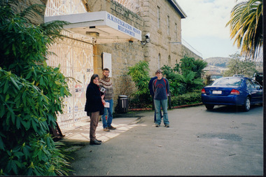 Wooragee Landcare Group
Photograph, 2004
... image holds in representing the events Wooragee Landcare Group held in order to educate the public. The photograph also exemplifies the historic significance of the area due to the Beechworth Prison's relation to important historical eras and events. Wooragee Wooragee Landcare Wooragee Landcare Group beechworth prison h.m beechworth prison beechwoth gaol ned kelly greg johnson agriculture victoria Department of Primary Industries DPI Reverse: WAN NA E0NA0N2. NN1- 1 2906 / [PRINTED] (No.15) / 870 Landscape ...This photo was taken in 2004 and pictures Luke Bailey and Glen Scholfield, the Wooragee Landcare Group coordinator, outside Beechworth Prison. This was the last year Wooragee Landcare Group met with Beechworth Prison Farm and Industry Managers at the prison itself, where they discussed weed and rabbit control on the prison's 'Rockery' block. The weed and rabbit controls that were explored in this event aimed to educate people on how to manage common pests in the Wooragee landscape and improve the appearance of the Beechworth Prison. The Beechworth prison itself is significant as it was built between 1859 and 1864 and is designed using a radiating 'panopticon' method which had proved an efficient, cost-effective design for easy surveillance of prisoners by allowing guards to watch over a large area from a central observation point. The prison is historically significant for its association with the early development of Beechworth as the government administrative centre of north-eastern Victoria. It is part of a major precinct of public buildings and has links to numerous other places in Beechworth which used granite quarried and broken at the prison by male inmates. It is also significant for its associations with the bushranger Ned Kelly and the Kelly storyThe photo holds significance due to the social and educational context the image holds in representing the events Wooragee Landcare Group held in order to educate the public. The photograph also exemplifies the historic significance of the area due to the Beechworth Prison's relation to important historical eras and events.Landscape coloured photograph printed on gloss paperReverse: WAN NA E0NA0N2. NN1- 1 2906 / [PRINTED] (No.15) / 870wooragee, wooragee landcare, wooragee landcare group, beechworth prison, h.m beechworth prison, beechwoth gaol, ned kelly, greg johnson, agriculture victoria, department of primary industries, dpi -
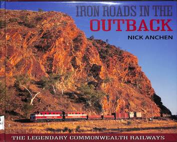 Victorian Railway History Library
Book, Nick Anchen, Iron Roads in the Outback, 2017
... landscapes on Earth. They were railways like no other, where men and women battled extreme temperatures, flash floods and maddening isolation to keep the trains running. This publication is the culmination of 25 years of Outback exploration, research, photography and interviews by author Nick Anchen. The result is a diverse book which brings to life both the beauty and harshness of the Australian Outback, through a collection of fascinating and historic images ...The Iron Roads of the Australian Outback - the legendary Commonwealth Railways were built through some of the harshest landscapes on Earth. They were railways like no other, where men and women battled extreme temperatures, flash floods and maddening isolation to keep the trains running. This publication is the culmination of 25 years of Outback exploration, research, photography and interviews by author Nick Anchen. The result is a diverse book which brings to life both the beauty and harshness of the Australian Outback, through a collection of fascinating and historic images, along with the memories of former Commonwealth Railways employees. Following an introductory chapter on the vastness and grandeur of the Australian interior - highlighted by the memoirs of 1950s flying doctor Macarthur Job - the book delves into the story of the Central Australia Railway. This was the line built through the 'back of beyond' - the forbidding desert country of South Australia and the Northern Territory. It was here that operators of famous trains such as The Ghan battled searing heat, dust storms and raging floodwaters to keep the trains running. The chapter includes stories by well known Ghan conductor 'Aspro' Lyons, and 'Piano Playing Chef' Paddy Greenfield - along with enginemen Wolf Markowski and John Theel, both of whom worked trains on this famous railway. The story of the North Australia Railway - 'The Line to Nowhere' - is the tale of a ramshackle railway which came alive during the dark days of World War II. The memoirs of wartime engineman Jim Prentice are eye opening, as are the hair raising accounts of surviving Tropical Cyclone Tracy, as told by rolling stock foreman Bill Donaldson. The Trans-Australian Railway was built across one of the harshest and loneliest environments on Earth - the vast Nullarbor Plain. Stories from enginemen Jack Slattery and Ron Howrie, along with Nullarbor resident and roadmaster's wife Cathy Beek, tell not only of the rudimentary living conditions and maddening isolation, but of the great camaraderie amongst the railway people who kept trains such as the Trans-Australian and the Tea and Sugar running. As well as examining the ruins and relics from the long-closed CR narrow gauge lines, the book also includes a chapter on the much-loved Pichi Richi Railway - the last surviving portion of that great Transcontinental Railway dream from another age.ill, maps, p.208.non-fictionThe Iron Roads of the Australian Outback - the legendary Commonwealth Railways were built through some of the harshest landscapes on Earth. They were railways like no other, where men and women battled extreme temperatures, flash floods and maddening isolation to keep the trains running. This publication is the culmination of 25 years of Outback exploration, research, photography and interviews by author Nick Anchen. The result is a diverse book which brings to life both the beauty and harshness of the Australian Outback, through a collection of fascinating and historic images, along with the memories of former Commonwealth Railways employees. Following an introductory chapter on the vastness and grandeur of the Australian interior - highlighted by the memoirs of 1950s flying doctor Macarthur Job - the book delves into the story of the Central Australia Railway. This was the line built through the 'back of beyond' - the forbidding desert country of South Australia and the Northern Territory. It was here that operators of famous trains such as The Ghan battled searing heat, dust storms and raging floodwaters to keep the trains running. The chapter includes stories by well known Ghan conductor 'Aspro' Lyons, and 'Piano Playing Chef' Paddy Greenfield - along with enginemen Wolf Markowski and John Theel, both of whom worked trains on this famous railway. The story of the North Australia Railway - 'The Line to Nowhere' - is the tale of a ramshackle railway which came alive during the dark days of World War II. The memoirs of wartime engineman Jim Prentice are eye opening, as are the hair raising accounts of surviving Tropical Cyclone Tracy, as told by rolling stock foreman Bill Donaldson. The Trans-Australian Railway was built across one of the harshest and loneliest environments on Earth - the vast Nullarbor Plain. Stories from enginemen Jack Slattery and Ron Howrie, along with Nullarbor resident and roadmaster's wife Cathy Beek, tell not only of the rudimentary living conditions and maddening isolation, but of the great camaraderie amongst the railway people who kept trains such as the Trans-Australian and the Tea and Sugar running. As well as examining the ruins and relics from the long-closed CR narrow gauge lines, the book also includes a chapter on the much-loved Pichi Richi Railway - the last surviving portion of that great Transcontinental Railway dream from another age. commonwealth railways (australia) -- history., central australia railway -- history.