Showing 112 items matching "history of public reserves"
-
 Federation University Historical Collection
Book, Historic Sites Survey: North Central Study Area, 1979, 1979
... ...history of public reserves...Barker Library (top floor) Mount Helen goldfields The North Central Study Area included the Shires of Avoca, Bet Bet, east Loddon, Goulburn, Untly, Kara Kara, Korong, Maldon, Marong, Metcalfe, McIvor, Newstead, Strathfieldsaye, Stawell, Talbot, Clunes, Tullaroop and Waranga. castlemaine mount alexander goldfield maldon percydale warrenmang moliagul tarnagulla stuart mill the whipstick whroo rushworth graytown ironbark forest st arnoaud new bendigo landsborough inglewood kurting wedderburn wehla kooroora langham flat mcintyre rheola diamond hill fosterville coliban water works green gully newstead muckleford forest costerfield graytown bailieston waranga irrigaiton system eucalyptus distillery mia mia bridge korokubeal township researce concegella slate quarry chewton fryerstown kingower timor talbot majorca carisbroook clunes st arnaud taradale icomos dunolly limestone castlemaine slate quarry harcourt granite taradale railway viaduct loddon united waterworks trust gouldburn weir carisbrook lock-up history of tree planting in streets history of public reserves r.u. nicholls nurseryman thomas lang francis moss ballarat botanical gardens ballarat school of mines botanical gardens lake wendouree victoria park, ballarat muont holled smith ballaarat old cemetery planting eastern oval ballarat east botanical gardens ballarat east town hall gardens eureka stockade reserve ballarat observatory plantings yarrowee creek plantings yarrowee bluestone channels ballarat woollen mill band and albion mullock heap black hill plantings yarrowee creek channels canadian creek channel specimen vale channel poverty point reserve union jack reserve buninyong imperial mine, buninyong victoria street plantings bridge mall sturt street gardens ballarat avenue of honour plantings white flat oval plantings camp street elms burnt creek 153 page book with white plastic binding. ...The North Central Study Area included the Shires of Avoca, Bet Bet, east Loddon, Goulburn, Untly, Kara Kara, Korong, Maldon, Marong, Metcalfe, McIvor, Newstead, Strathfieldsaye, Stawell, Talbot, Clunes, Tullaroop and Waranga. 153 page book with white plastic binding. It is an historic sites survey for the North Central Study Area commissioned by the Land Conservation Council, the Ministry for COnservation and the Australian Heritage Commission. castlemaine, mount alexander goldfield, maldon, percydale, warrenmang, moliagul, tarnagulla, stuart mill, the whipstick, whroo, rushworth, graytown ironbark forest, st arnoaud, new bendigo, landsborough, inglewood, kurting, wedderburn, wehla, kooroora, langham flat, mcintyre, rheola, diamond hill, fosterville, coliban water works, green gully, newstead, muckleford forest, costerfield, graytown, bailieston, waranga irrigaiton system, eucalyptus distillery, mia mia bridge, korokubeal township researce, concegella slate quarry, chewton, fryerstown, kingower, timor, talbot, majorca, carisbroook, clunes, st arnaud, taradale, icomos, dunolly, limestone, castlemaine slate quarry, harcourt granite, taradale railway viaduct, loddon united waterworks trust, gouldburn weir, carisbrook lock-up, history of tree planting in streets, history of public reserves, r.u. nicholls nurseryman, thomas lang, francis moss, ballarat botanical gardens, ballarat school of mines botanical gardens, lake wendouree, victoria park, ballarat, muont holled smith, ballaarat old cemetery planting, eastern oval, ballarat east botanical gardens, ballarat east town hall gardens, eureka stockade reserve, ballarat observatory plantings, yarrowee creek plantings, yarrowee bluestone channels, ballarat woollen mill, band and albion mullock heap, black hill plantings, yarrowee creek channels, canadian creek channel, specimen vale channel, poverty point reserve, union jack reserve buninyong, imperial mine, buninyong, victoria street plantings, bridge mall, sturt street gardens, ballarat avenue of honour plantings, white flat oval plantings, camp street, elms, burnt creek -
 Warrnambool and District Historical Society Inc.
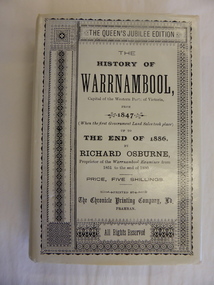
Book, The History of Warrnambool by Richard Osburne, 1980
... history. He was associated with the establishment of the Aboriginal Reserves, Fire Brigade, Mechanics’ Institute, Warrnambool Council, National School, Presbyterian Church, Public Wants Committee, Villiers Building Society, Fish Protection Society, Dramatic Club, Cricket Club, Otway Gold Exploration Syndicate and other institutions. ...history. He was associated with the establishment of the Aboriginal Reserves, Fire Brigade, Mechanics’ Institute, Warrnambool Council, National School, Presbyterian Church, Public Wants Committee, Villiers Building Society, Fish Protection Society, Dramatic Club, Cricket Club, Otway Gold Exploration Syndicate and other institutions. ...Richard Osburne (1825-1895) came to Warrnambool in 1847, a pioneer resident in the new settlement. In 1851, with John Wilkinson, he founded Warrnambool’s first newspaper, the Warrnambool Examiner, and issued it weekly for some months until he left the town for the goldfields. Returning in 1853 he resumed publication of the Examiner and continued it, intermittently in its last few years, until 1880. He was acknowledged in his day as the Father of the Warrnambool Press and was a dominant figure in Warrnambool’s early history. He was associated with the establishment of the Aboriginal Reserves, Fire Brigade, Mechanics’ Institute, Warrnambool Council, National School, Presbyterian Church, Public Wants Committee, Villiers Building Society, Fish Protection Society, Dramatic Club, Cricket Club, Otway Gold Exploration Syndicate and other institutions. In 1882 he went to live in Melbourne, returning to publish his ‘History of Warrnambool’ in 1887, a Queen’s Jubilee publication. Richard Osburne’s book is a seminal work of the 19th century history of Warrnambool and its importance cannot be over-emphasized. The original copies of this book are now hard to get and are very valuable. This facsimile is kept because the facsimiles are also now becoming rare and they are good examples of the way a facsimile is reproduced and the reason for the existence of this particular reprint– the importance and usefulness of Osburne’s history and the need to make it accessible to researchers today.This is a facsimile edition (1980) of Richard Osburne's book on the history of Warrnambool from 1847 to 1886. It is a hard cover buff-coloured book with gold lettering on the spine. The dust cover is cream-coloured paper with black writing. Inside the cover is a map of southwest Victoria (1880). There are five fold-up inserts (sketches, diagrams etc), a number of business advertisements, sepia photographs and sketches and an index. The dust cover includes information on the author. There are 25 chapters, a foreword by the Prime Minister of Australia, Malcolm Fraser and a Preface The proceeds of the book reprint went to Flagstaff Hill Maritime Village.This is a facsimile edition (1980) of Richard Osburne’s book on the history of Warrnambool from 1847 to 1886. It is a hard cover buff-coloured book with gold lettering on the spine. The dust cover is cream–coloured paper with black writing. Inside the cover is a map of southwest Victoria (1880). There are five fold-up inserts (sketches, diagrams etc), a number of business advertisements, sepia photographs and sketches and an index. The dust cover includes information on the author. There are 25 chapters, a foreword by the Prime Minister of Australia, Malcolm Fraser and a Preface The proceeds of the book reprint went to Flagstaff Hill Maritime Village.richard osburne, the history of warrnambool, warrnambool examiner -
Marysville & District Historical Society
THE TRIANGLE NEWS-VOL 39 NO 11-MARCH 30 2012
... history group...narbethong reunion...narbethong hall...emotions anonymous international meeting...travel the silk road at alexandra library...marysville real estate...buxton reserve news...marysville & district lions...maryton park b & b...marysville lake mountain visitor information centre...public...Marysville & District Historical Society 39 Darwin Street Marysville yarra-valley-and-the-dandenong-ranges marysville victoria australia wirreanda children's festival what's on when in april the committee of management of the gallipoli park precinct yarra valley yoga creative triangle cultural community agm marysville golf report triangle bushwalkers church notices triangle community pot luck dinner advertisements murrindindi shire council dog/cat registrations marysville pharmacy marysville medical clinic beyong bushfires petra meer journal workshop mayor's chair ladies lunch saladin lodge expressions of interest memorials consultation tender stage two marysville & district sesquicentenary celebrations narbethong history group narbethong reunion narbethong hall emotions anonymous international meeting travel the silk road at alexandra library marysville real estate buxton reserve news marysville & district lions maryton park b & b marysville lake mountain visitor information centre public notice THE TRIANGLE NEWS-VOL 39 NO 11-MARCH 30 2012 ...marysville, victoria, australia, wirreanda children's festival, what's on when in april, the committee of management of the gallipoli park precinct, yarra valley yoga, creative triangle, cultural community agm, marysville golf report, triangle bushwalkers, church notices, triangle community pot luck dinner, advertisements, murrindindi shire council, dog/cat registrations, marysville pharmacy, marysville medical clinic, beyong bushfires, petra meer journal workshop, mayor's chair, ladies lunch, saladin lodge, expressions of interest, memorials consultation tender stage two, marysville & district sesquicentenary celebrations, narbethong history group, narbethong reunion, narbethong hall, emotions anonymous international meeting, travel the silk road at alexandra library, marysville real estate, buxton reserve news, marysville & district lions, maryton park b & b, marysville lake mountain visitor information centre, public notice -
 Orbost & District Historical Society
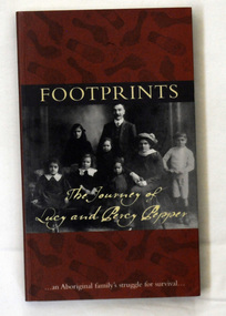
book, Footprints, 2008
... -co-author Simon Flagg from the Koorie Records Unit, Public Record Office Victoria, This book, with its transcripts of original letters, is an invaluable historical resource for university and school students on Aboriginal history in Victoria and what happened on Aboriginal reserves. pepper-family aboriginal-history A book titled "Footprints", which portrays the struggles of Lucy and Percy Pepper in the first half of the twentieth century. ...Co-author Simon Flagg from the Koorie Records Unit, Public Record Office Victoria, did most of the research for the book. Rita Watkins, a descendent of Percy and Lucy, provided photographs and family stories for the book. "As well as brief chapter introductions, the book contains transcripts of the letters to, from and about the Pepper Family. Among various aspects of the family's life, the letters show Lucy Pepper's long battle with tuberculosis and her request to live with other family members on a mission. But she was denied this natural wish because 'half-caste' Aboriginal people were excluded from the missions." -co-author Simon Flagg from the Koorie Records Unit, Public Record Office Victoria,This book, with its transcripts of original letters, is an invaluable historical resource for university and school students on Aboriginal history in Victoria and what happened on Aboriginal reserves. A book titled "Footprints", which portrays the struggles of Lucy and Percy Pepper in the first half of the twentieth century. It was published jointly by the National Archives of Australia and Public Record Office Victoria, both of which hold original records of the family's correspondence with bureaucracy over the years. The book was authored by Simon Flagg and Dr Sebastian Gurciullo. The cover has a dark brown background with black footprints printed over it. They are both bare foot and shoe prints. It has a b /w photograph of a family posed for the camera. Across the top is the title FOOTPRINTS printed in pale yellow. At the bottom of the photo in pale yellow script is "the journey of Lucy and Percy Pepper". At the foot of the front cover is " An Aboriginal Family's struggle for survival". pepper-family aboriginal-history -
 Glen Eira Historical Society
Letter - Rosstown Railway
... Public Meetings Meetings Ross James Hogan O.B. ARROW ENGRAVING Campbell F. Snowball Miss. Elsternwick Gladstone Parade Nineteen Walters W.R. Marara Road Gardens Marara Road Marara Gardens Narrawong Road Ceremonies Caulfield Mayors Polglase Norma Mayoral Secretaries Railways Routes Documents Correspondence Rudski Brian Calder Graham Events and Activities Official Buildings Insignia Local Government Local Officials and Employees Parks and Reserves Buildings Structures and Establishments Official Events Festivals and Celebrations Occupations Political Processes Local History History Financial Economics Local Government Finance Letter Rosstown Railway ...This file contains two items: 1/A group of eight letters, predominantly between Hon. Secretary of Caulfield Historical Society R. Ballantyne and members of the Caulfield City Council written between 1981 and 1983, regarding the installation of a plaque in commemoration of the centenary of the Rosstown Railway. The first two letters are handwritten from R. Ballantyne to G. Calder and Carol Camy, dated 01/06/1981 and 22/02/1982. The letter to G. Calder supports a suggestion in the May edition of the CAULFIELD CONTACT for the installation of a plaque in celebration of the centenary of the Rosstown Railway, suggesting a potential site for another plaque on Curraweena Road. The letter to Carol Harry discusses the costing of the plague and a possible contribution towards this cost from the Caulfield Historical Society. The letter appears to be incomplete, having no sign off from the author. Attached to the letter is what appears to be a suggestion for the inscription of the plaque. The letters addressed to R. Ballantyne are typed and dated 12/06/1981, 24/06/1981, 14/07/19891, 17/12/1981 and 08/09/1983, from A. Craig and D.B. Hogan on behalf of City Manager G.K. Calder and City Liason Officer Carol Harry. All letters concern the commemorative plaque, with these from Carol Harry including handwritten notes which appear to be in R. Ballantyne’s handwriting. The final letter is from Mayoral Secretary Norma Polglase to Miss B. Snowball, dated 23/08/1983, inviting her to attend the unveiling of the plaque. Also included in the item are Council Committee Meeting minutes, dated 16/05/1981, broaching the subject of installing the plaque in Koornang Road. 2/Four colour photographs and two black and white copies of one of the photographs, all dated 18/09/1983 and showing the opening of the commemorative plaque in Marrara Gardens. Two photographs picture Mayor Brian Rudski and City Manager Graham Calder with a crowd of unidentified people present. One photograph and both copies are of the inscription on the plaque, with the wording identical to that of the handwritten note by R. Ballantyne, in item one.caulfield, caulfield south, calder g.k., calder g., hawthorn road, glen eira road, ballantyne r., office workers, caulfield contact, norman peter, groups, glen huntly, koornang road, mills, sugar mills, caulfield historical society, caulfield city council, caulfield town hall, official buildings, glen huntly neville street fourteen, parliamentary representatives, rosstown, rosstown railway, rosstown railway centenary, festivals and celebrations, centenaries, historical markers, plaques, monuments and memorials, ross murray, railways, land transport, curraweena road, parts of buildings or structures, bluestone structures, construction materials, caulfield community liaison officer, harry carol, currency, finances, onley peter, elsternwick, oakleigh, council meetings, caulfield council chambers, caulfield municipal chambers, caulfield municipal offices, craig a., caulfield city manager, city of caulfield, caulfield physical environment committee, public meetings, meetings, ross james, hogan o.b., arrow engraving, campbell f., snowball miss., elsternwick gladstone parade nineteen, walters w.r., marara road gardens, marara road, marara gardens, narrawong road, ceremonies, caulfield mayors, polglase norma, mayoral secretaries, railways routes, documents, correspondence, rudski brian, calder graham, events and activities, official buildings, insignia, local government, local officials and employees, parks and reserves, buildings structures and establishments, official events, festivals and celebrations, occupations, political processes, local history, history, financial economics, local government finance -
Glen Eira Historical Society
Document - History of the City of Caulfield
... history of the City of Caulfield’. 13 pages. Covers the following subjects: Powers, Planning, Public Works, Trading Undertakings, Health Services, Municipalities, Wards Electors or Ratepayers, Voters Roll, Councillors, Officers, Finance, Nature of Soil and Vegetation, Parks and Gardens and Reserves, Coat of Arms, Boundaries, How Did Caulfield get its Name, Aboriginal Influence, Caulfield Road Board, Shire of Caulfield, Borough and Town and the City of Caulfield. ...history of the City of Caulfield’. 13 pages. Covers the following subjects: Powers, Planning, Public Works, Trading Undertakings, Health Services, Municipalities, Wards Electors or Ratepayers, Voters Roll, Councillors, Officers, Finance, Nature of Soil and Vegetation, Parks and Gardens and Reserves, Coat of Arms, Boundaries, How Did Caulfield get its Name, Aboriginal Influence, Caulfield Road Board, Shire of Caulfield, Borough and Town and the City of Caulfield. ...This file contains 4 items: 1/Typewritten document titled ‘The City of Caulfield’. Author and date unknown. 1 page (back and front), 2 copies. Document covers topics such as origins of the name ‘Caulfield’, early settlement and the Caulfield Cup. 2/Typewritten document titled ‘History of Caulfield Council’. Author and date unknown. 6 pages, 3 copies. Document covers subjects such as early settlement, Aboriginal influence, Caulfield Road Board, Shire of Caulfield, Borough and town boundaries, coat of arms, and Freedom of Entry to the City. 3/Typewritten document (undated + author unknown) titled ‘The Structure of Local Government in Victoria with a history of the City of Caulfield’. 13 pages. Covers the following subjects: Powers, Planning, Public Works, Trading Undertakings, Health Services, Municipalities, Wards Electors or Ratepayers, Voters Roll, Councillors, Officers, Finance, Nature of Soil and Vegetation, Parks and Gardens and Reserves, Coat of Arms, Boundaries, How Did Caulfield get its Name, Aboriginal Influence, Caulfield Road Board, Shire of Caulfield, Borough and Town and the City of Caulfield. Also covered is early settlement. Note at the end of the document mentions that the historical content contained in the last section was based upon a thesis for the Department of Town and Regional Planning, University of Melbourne, 1968 by L. Alwis, P. Rowe, N. Wootten. Melbourne, ‘City of Caulfield: An Illustrated City Report’. 4/Typewritten document (undated) titled ‘The Structure of Local Government in Victoria with notes on the history of the City of Caulfield’. 8 pages, 2 copies. This document also includes a map/diagram of the city with boundaries and wards showing locations of railway stations and parks. Document covers the structure of local government and its functions then goes on to focus on City of Caulfield with subjects similar to those covered in item 3. Document signed off by Deputy Town Clerk.city of caulfield, caulfield john, caulfield baron, caulfield racecourse, elsternwick, ripponlea, st. mary’s church, caulfield council, kooyong road, neerim road, bambra road, greenmeadows house, caulfield park, paddy’s swamp, dandenong road, caulfield grammar school, chisholm institute of technology, murrumbeena, glen eira road, alma road, orrong road, balaclava road, inkerman road, ‘grosmont’, caulfield school room, caulfield road board, caulfield road district, crimean war, victorian amateur turf club, caulfield cup, glenhuntly road, north road, glenhuntly station, ormond station, outer circle railway, local government, gardenvale, carnegie, rosstown, poath road, nepean highway, hotham street, ormond park, princes park, ross william murray, caulfield institute of technology, ‘ross’ folly’, hawthorn road, glenhuntly, ormond, morris t. w., lloyd charles du plan, meals on wheels, shire of caulfield, caulfield railway station, caulfield rsl, bouran road, murrum murrumbeen, kooyong road, great dandenong road, neerim road, trams, prahran and malvern tramways trust, fisher andrew, mackinnon reserve, dover street, ‘glen eira’, blair max cr., insignia, third ordnance services unit, schools, street lighting, lampriere, mr. bevan, the caulfield leader, davies j. henry, curraweena road, st. georges road, o’neill college, hope george, market gardens, koornang reserve, packer reserve, murrumbeena reserve, hopetoun gardens, greenmeadows gardens, mirambeena, caulfield technical college, hart john, langdon h. j., ‘rosecraddock’, judge webb, ‘crotonhurst’, service james, ‘kilwinning’, ricketson henry, grimwade frederick sheppard, airdrie, jenner, st. aubin’s, caulfield john p. t., harlston, lempriere, lord reserve, ‘cantala’ -
 Eltham District Historical Society Inc
Photograph - Digital Photograph, Alan King, Edendale Farm Homestead, 29 January 2008
... reserves and roadsides and support Nillumbik Friends environmental groups. The Friends propagate plants at the nursery, which grows indigenous plants and sells these to the public.3 The centre demonstrates the sustainable living the farm teaches, with features like solar hot water and drive lighting and for the fireplace, logs of recycled cardboard. Edendale has had a varied history...reserves and roadsides and support Nillumbik Friends environmental groups. The Friends propagate plants at the nursery, which grows indigenous plants and sells these to the public.3 The centre demonstrates the sustainable living the farm teaches, with features like solar hot water and drive lighting and for the fireplace, logs of recycled cardboard. Edendale has had a varied history ...Edendale Farm is Nillumbik Shire Council's environment centre situated in Gastons Road, Eltham between the railway and the Diamond Creek. The homestead on the property was built in 1896 and is of historical significance, being the subject of a Heritage Overlay under the Nillumbik Planning Scheme. The Edendale property was originally part of an extensive land purchase in 1852 from the Crown by pioneer Eltham farmer Henry Stooke. He initially purchased 51 acres and later expanded his holdings by purchasing another three adjacent Crown allotments extending northerly from Josiah Holloway's Little Eltham subdivision. Despite clearing the land, Stooke did not build on this property, choosing to live on his property "Rosehill" at Lower Plenty. In 1896 Thomas Cool, Club Manager of the Victoria Coffee Palace in Melbourne purchased 7 acres of the original Stooke land and built the house now known as Edendale. Cool did not farm the land, instead using it as a gentleman’s residence, retiring to Eltham at weekends. In 1918 he purchased an additional 7 acres but in 1919 he sold the property. Later owners included J.W. Cox, the Gaston family and D. Mummery. In the 1980s the Eltham Shire Council purchased the site for use as a Council depot, but this use did not proceed. Subsequently, it was used as the Council pound. The Edendale Farm Pet Education and Retention Centre was established in the summer of 1988/1989 and was set up to replace the existing dog kennels with a high standard pet retention centre. The design style of the building was established to compliment the features of the existing house. It was equipped with 10 retention pens, a veterinary room and a pet education area where school children and other interested parties learnt about pet care procedures. It was later developed into a community farm and was run by an advisory committee and in 2000 it became an Environment Centre. In early 2006 an advisory committee was established for the development of a master plan for future development at Edendale Farm. The committee included Russell Yeoman, a former long-time shire planner and founding member of the Eltham District Historical Society. At the time of filming the Master Plan and future for Edendale was about continuing to develop Edendale as a centre of environment learning and looking at expanding displays and school program, running a lot more of life-long learning and workshops around sustainable living. Covered under Heritage Overlay, Nillumbik Planning Scheme. Published: Nillumbik Now and Then / Marguerite Marshall 2008; photographs Alan King with Marguerite Marshall.; p101 A sharp turn from busy Wattletree Road by the railway line, brings a surprise. Only 1.4 km from Eltham’s centre, sheep feed, blissfully unaware of the hectic suburban activity so close by. At the entrance to the 5.6ha Edendale Farm is another surprise. A work of art that looks like huge tree trunks transformed into bowler and top-hatted men. The Fences Act 1968 by Tony Trembath with Mark Cain and John Doyle, 1996, is classified by the National Trust of Australia as having Regional Significance. The title refers to a government act on disputes between neighbors over the placement of fences and boundaries. This takes a ‘wry swipe’ at a community divided by trivial squabbles. It also celebrates making do with limited resources.1 Further along on the left, the office wall is decorated with a massive Eltham Copper Butterfly, designed by Robert Tickner and made by school children with used plastic bottles and other waste material. Nillumbik Council runs Edendale as an Environmental Education Centre, to help preserve and enhance the local environment. As early as 1988 the former Eltham Shire Council realised Edendale’s importance in meeting people’s needs, particularly of children, to enjoy farmland. The centre, with the Eltham North Reserve to the north - including remnant bushland and open parkland - makes up the major part of the public open space for this area. The council considers this area will become increasingly important to the local community for recreational use.2 Educational programs aim to encourage community involvement to ensure the long-term rehabilitation and protection of natural bushland areas. Edendale is used by people of all ages - from school children to adults - for environmental programs and workshops, as well as for recreation, to enjoy the domestic animals and to picnic. Edendale is also home to the Environmental Works staff who manage reserves and roadsides and support Nillumbik Friends environmental groups. The Friends propagate plants at the nursery, which grows indigenous plants and sells these to the public.3 The centre demonstrates the sustainable living the farm teaches, with features like solar hot water and drive lighting and for the fireplace, logs of recycled cardboard. Edendale has had a varied history as a dog pound and even as a retreat for Thomas Cool, Club Manager of the Victoria Coffee Palace in Melbourne. His single-storey weatherboard house built in 1896, which still stands, was grander than most homes in Eltham. Although such buildings were common in many other parts of Melbourne, Eltham’s poverty and remoteness did not encourage such construction. The Victorian rectangular-shaped house, with a corrugated iron roof and veranda, has elegant large rooms, leadlight windows, ceiling roses, two bay windows and ornately carved wooden fireplace surrounds. Cool bought seven acres (2.8ha) from pioneer Eltham farmer Henry Stooke’s 200 acre (81ha) farm, which he had bought from the Crown in 1852. In 1918 Cool bought an extra seven acres (2.8ha) but in 1919 sold the estate to farmer John Cox. In 1933 Cox sold Edendale to Mrs Elizabeth Gaston, after whom the road leading to the centre was named. The property was owned by several Gaston family members, who called it Edendale, then by a police constable, Douglas Mummery, until the Shire of Eltham bought it in 1970. Oddly Edendale was known as Mummery’s for almost 20 years, although Mummery owned it only for a short time.4 The shire used Edendale as a dog pound until amalgamation with other municipalities in 1996. The pound then moved to the Yan Yean Road, Plenty site, which had been used by the former Diamond Valley Shire Council. To the west and north the centre is bounded by Diamond Creek and on the east by the Melbourne-Hurstbridge railway line. Part of the Research creek forms the centre’s southern boundary.This collection of almost 130 photos about places and people within the Shire of Nillumbik, an urban and rural municipality in Melbourne's north, contributes to an understanding of the history of the Shire. Published in 2008 immediately prior to the Black Saturday bushfires of February 7, 2009, it documents sites that were impacted, and in some cases destroyed by the fires. It includes photographs taken especially for the publication, creating a unique time capsule representing the Shire in the early 21st century. It remains the most recent comprehenesive publication devoted to the Shire's history connecting local residents to the past. nillumbik now and then (marshall-king) collection, edendale farm -
Glen Eira Historical Society
Document - Lempriere Avenue, 10, St. Kilda East
... history of the property at 10 Lempriere Avenue, St. Kilda East, built on a subdivision of the land of William George Lempriere. Includes some information on the Lempriere Family and public park, Greenmeadows Gardens. The document by Rosalind Landells, David Bick and Hilary Bullock of the Brighton Historical Society is dated October 30, 1995. Includes handwritten notes covering mostly same information. Includes bibliography. Greenmeadows Lempriere William George Clarke William Senior Lempriere John Thomson Zimmerman A.K. Nelson Frank L. Greenmeadows Gardens Lempriere Avenue Nelson M.D. St. Kilda East Parks and Reserves ...A brief history of the property at 10 Lempriere Avenue, St. Kilda East, built on a subdivision of the land of William George Lempriere. Includes some information on the Lempriere Family and public park, Greenmeadows Gardens. The document by Rosalind Landells, David Bick and Hilary Bullock of the Brighton Historical Society is dated October 30, 1995. Includes handwritten notes covering mostly same information. Includes bibliography.greenmeadows, lempriere william george, clarke william senior, lempriere john thomson, zimmerman a.k., nelson frank l., greenmeadows gardens, lempriere avenue, nelson m.d., st. kilda east, parks and reserves, zucker a.a., greenmeadows lane, lempriere family, lempriere’s paddock, councillors -
 Bendigo Historical Society Inc.
Photograph - PALL MALL: HUSTLER'S ROYAL RESERVE MINE, early 1900
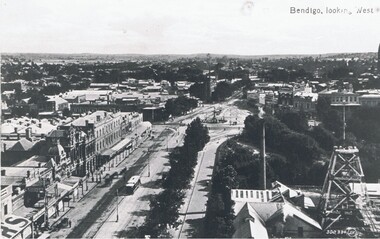
... History House 11 Mackenzie Street Bendigo goldfields PLACE Aerial view of bendigo pall mall Valentine ? Black and white photo . View of Pall Mall and Hustler's Royal Reserve Mine, Bendigo, looking west. James Lerk ( 5/11/1999 ) 'View from the public ...Black and white photo . View of Pall Mall and Hustler's Royal Reserve Mine, Bendigo, looking west. James Lerk ( 5/11/1999 ) 'View from the public offices tower, Hustler's Royal Reserve Mine, from the post office tower 'Valentine ?place, aerial view of bendigo, pall mall -
 Bendigo Historical Society Inc.
Newspaper - LONG GULLY HISTORY GROUP COLLECTION: LONG GULLY SCHOOL HAS A PROUD RECORD
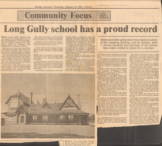
... History Group - Long Gully School has a Proud Record... Bendigo Advertiser 14/2/1990... Maurie McDonald... Long Gully Primary School No 2120... Alan Crossley... Colin Buzza...Long Gully Post Office... 1872 Education Act... California Gully No 123... Rae's Ironbark School No 323... Violet Street No 877... Long Gully Mechanics' Institute... Shamrock Hotel Sandhurst... Wesleyan School... German School... Mr Blaney's School... Sandhurst Board of Advice... Church of England Reserve... Crawford Brothers... Bath Hotel Sandhurst... Minister of Public...History House 11 Mackenzie Street Bendigo goldfields BENDIGO History long gully history group The Long Gully History Group - Long Gully School has a Proud Record Bendigo Advertiser 14/2/1990 Maurie McDonald Long Gully Primary School No 2120 Alan Crossley Colin Buzza Long Gully Post Office 1872 Education Act California Gully No 123 Rae's Ironbark School No 323 Violet Street No 877 Long Gully Mechanics' Institute Shamrock Hotel Sandhurst Wesleyan School German School Mr Blaney's School Sandhurst Board of Advice Church of England Reserve Crawford Brothers Bath Hotel Sandhurst Minister of Public Instruction Manchester Arms Newspaper cutting titled Long Gully school has a proud record. ...Newspaper cutting titled Long Gully school has a proud record. Paper dated Wednesday, February 14, 1990. Article was Community Focus with Maurie McDonald. The school was holding a reunion on Sunday, April 1. Article mentions some history of the school, distances from other schools and the meetings and a petition to get the school. Eventually a tender was accepted from Crawford Brothers, Bath Hotel, Sandhurst, for 2745 pounds, for the erection of the new building with an extra 50 pound for white brick facings. The new school was opened by the Minister of Public Instruction on January 15, 1879. There is a photo of the school in the article. There are also two pink photo copies of the article. One has the last line under the photo not printed.bendigo, history, long gully history group, the long gully history group - long gully school has a proud record, bendigo advertiser 14/2/1990, maurie mcdonald, long gully primary school no 2120, alan crossley, colin buzza, long gully post office, 1872 education act, california gully no 123, rae's ironbark school no 323, violet street no 877, long gully mechanics' institute, shamrock hotel sandhurst, wesleyan school, german school, mr blaney's school, sandhurst board of advice, church of england reserve, crawford brothers, bath hotel sandhurst, minister of public instruction, manchester arms -
 Bendigo Historical Society Inc.
Photograph - FOUNTAIN IN ROSLIND PARK
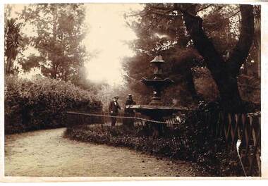
... History House 11 Mackenzie Street Bendigo goldfields PLACE Public gardens rosalind park Fountain in Roslind Park. Bendigo. Violet and Mr Baker. Photograph - black and white. Written on back of photo -' Fountain in Rosalind Park, old camp reserve ...Photograph - black and white. Written on back of photo -' Fountain in Rosalind Park, old camp reserve. Violet and Mr Baker'. The photo shows a three tier fountain, water emitting from top, surrounded by a simple metal fence. Man and woman standing alongside fence looking at fountain, presumably Violet and Mr. Baker.place, public gardens, rosalind park, fountain in roslind park. bendigo. violet and mr baker. -
 Bendigo Historical Society Inc.
Photograph - AUSTIN COLLECTION: Ray Beer, Central Deborah Gold Mine
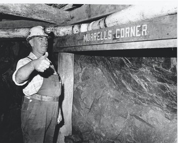
... public in 1971. Initially the surface was open for just 12 hours a week and as the demand for viewing a part of Bendigo's history increased, so did the opening hours. In 1974 the mine was gazetted as a Public Historical Purposes Reserve...public in 1971. Initially the surface was open for just 12 hours a week and as the demand for viewing a part of Bendigo's history increased, so did the opening hours. In 1974 the mine was gazetted as a Public Historical Purposes Reserve ...Ray Beer was an employee of the Central Deborah Gold Mine. February 15th 2009: Bendigo Advertiser: 'MINING stalwart Raymond Beer has died at the age of 74 after a battle with cancer. He leaves behind an extended family and a legacy in Bendigo’s mining history. Ray was mine manager at the Central Deborah Gold Mine - appointed in 1978 - and led the team that made possible the underground project at the second level. He had a vision to allow visitors to go underground and experience Bendigo’s mining heritage first hand. Ray was responsible for developing the new battery, shaft and poppet head to make this a reality. It took persistence and lots of hard work. Friend and work colleague Bill McNamara said Ray was as good as 10 men. His enthusiasm and work ethic were unprecedented. Ray will be sadly missed by his wife, Thelma, six children, 15 grandchildren, seven brothers, three sisters, his extended family, and friends. He will be remembered for his kindness, tenacity and strength of character. In recognition of his contribution to Bendigo’s mining history, after more than 20 years of service at his retirement, a bronze life-sized statue was unveiled in his honour'. Central Deborah Gold Mine history: At its peak, Central Deborah Gold Mine reached a depth of 412 metres. It has 17 separate levels and 15 kilometres of drives and cross cuts (tunnels). The Central Deborah was very much a hands-on mine and the conditions that the miners worked in would be considered shocking by today's standards – being lowered underground in a cage with only two sides, often working ankle to knee deep in water, filling up to 32 ore trucks a shift by hand which were then pushed a mile or more along rails in the drives, working by carbide lamp, breathing in the fumes and rock dust and communication by bells. Geez, they were ironmen. However, at the time working conditions were considered to be among the best on the goldfields at Central Deborah, after all it was one of the only mines that had hot showers. Following Central Deborah Gold Mine's closure, the Bendigo skyline began to noticeably change. Obvious remnants of mining such as poppet heads, engine rooms, service quarters, battery houses and chimneys were steadily disappearing. After intense lobbying by the local community, the Bendigo City Council purchased the still very much intact Central Deborah Gold Mine in 1970 for a mere $6,000 to ensure that a vital link to Bendigo's historic golden past was maintained. The Bendigo Trust was then formed to oversee the operations of the Central Deborah Gold Mine, which led to the surface of the mine being opened to the public in 1971. Initially the surface was open for just 12 hours a week and as the demand for viewing a part of Bendigo's history increased, so did the opening hours. In 1974 the mine was gazetted as a Public Historical Purposes Reserve and attracted such visitors as H.R.H Prince Charles. By far the greatest shortcoming at this stage was that no one could view the underground workings, as these had become flooded. After what could only be described as a monumental effort by everyone involved, Level 2 of the mine was officially opened to the public by the Premier of Victoria, the Honourable John Cain, on 20 June 1986, which brought to fruition a long standing dream.Black and white photograph. Ray Beer, underground at Central Deborah Gold Mine, standing alongside wooden sign 'Murrell's Corner'. Sign is placed horizontally on timber supports, side of drive visible in background. Ray is wearing bib and brace overalls and hard hat with a belt around his waist. He is giving a 'thumbs up' sign. gold mining, central deborah gold mine, ray beer, mine manager -
 Bendigo Historical Society Inc.
Photograph - AUSTIN COLLECTION: Central Deborah Gold Mine Lift Shaft
... public in 1971. Initially the surface was open for just 12 hours a week and as the demand for viewing a part of Bendigo's history increased, so did the opening hours. In 1974 the mine was gazetted as a Public Historical Purposes Reserve...public in 1971. Initially the surface was open for just 12 hours a week and as the demand for viewing a part of Bendigo's history increased, so did the opening hours. In 1974 the mine was gazetted as a Public Historical Purposes Reserve ...Central Deborah Gold Mine history: At its peak, Central Deborah Gold Mine reached a depth of 412 metres. It has 17 separate levels and 15 kilometres of drives and cross cuts (tunnels). The Central Deborah was very much a hands-on mine and the conditions that the miners worked in would be considered shocking by today's standards – being lowered underground in a cage with only two sides, often working ankle to knee deep in water, filling up to 32 ore trucks a shift by hand which were then pushed a mile or more along rails in the drives, working by carbide lamp, breathing in the fumes and rock dust and communication by bells. Geez, they were ironmen. However, at the time working conditions were considered to be among the best on the goldfields at Central Deborah, after all it was one of the only mines that had hot showers. Following Central Deborah Gold Mine's closure, the Bendigo skyline began to noticeably change. Obvious remnants of mining such as poppet heads, engine rooms, service quarters, battery houses and chimneys were steadily disappearing. After intense lobbying by the local community, the Bendigo City Council purchased the still very much intact Central Deborah Gold Mine in 1970 for a mere $6,000 to ensure that a vital link to Bendigo's historic golden past was maintained. The Bendigo Trust was then formed to oversee the operations of the Central Deborah Gold Mine, which led to the surface of the mine being opened to the public in 1971. Initially the surface was open for just 12 hours a week and as the demand for viewing a part of Bendigo's history increased, so did the opening hours. In 1974 the mine was gazetted as a Public Historical Purposes Reserve and attracted such visitors as H.R.H Prince Charles. By far the greatest shortcoming at this stage was that no one could view the underground workings, as these had become flooded. After what could only be described as a monumental effort by everyone involved, Level 2 of the mine was officially opened to the public by the Premier of Victoria, the Honourable John Cain, on 20 June 1986, which brought to fruition a long standing dream.Black and white photograph, looking from bottom of lift shaft towards the surface; light visible at top of shaft. Lift cables and safety mesh on sides of shaft. gold mining, central deborah gold mine, ray beer, mine manager -
 Bendigo Historical Society Inc.
Photograph - AUSTIN COLLECTION: Central Deborah Gold Mine, Possibly 1990's
... public in 1971. Initially the surface was open for just 12 hours a week and as the demand for viewing a part of Bendigo's history increased, so did the opening hours. In 1974 the mine was gazetted as a Public Historical Purposes Reserve...public in 1971. Initially the surface was open for just 12 hours a week and as the demand for viewing a part of Bendigo's history increased, so did the opening hours. In 1974 the mine was gazetted as a Public Historical Purposes Reserve ...Central Deborah Gold Mine history: At its peak, Central Deborah Gold Mine reached a depth of 412 metres. It has 17 separate levels and 15 kilometres of drives and cross cuts (tunnels). The Central Deborah was very much a hands-on mine and the conditions that the miners worked in would be considered shocking by today's standards – being lowered underground in a cage with only two sides, often working ankle to knee deep in water, filling up to 32 ore trucks a shift by hand which were then pushed a mile or more along rails in the drives, working by carbide lamp, breathing in the fumes and rock dust and communication by bells. Geez, they were ironmen. However, at the time working conditions were considered to be among the best on the goldfields at Central Deborah, after all it was one of the only mines that had hot showers. Following Central Deborah Gold Mine's closure, the Bendigo skyline began to noticeably change. Obvious remnants of mining such as poppet heads, engine rooms, service quarters, battery houses and chimneys were steadily disappearing. After intense lobbying by the local community, the Bendigo City Council purchased the still very much intact Central Deborah Gold Mine in 1970 for a mere $6,000 to ensure that a vital link to Bendigo's historic golden past was maintained. The Bendigo Trust was then formed to oversee the operations of the Central Deborah Gold Mine, which led to the surface of the mine being opened to the public in 1971. Initially the surface was open for just 12 hours a week and as the demand for viewing a part of Bendigo's history increased, so did the opening hours. In 1974 the mine was gazetted as a Public Historical Purposes Reserve and attracted such visitors as H.R.H Prince Charles. By far the greatest shortcoming at this stage was that no one could view the underground workings, as these had become flooded. After what could only be described as a monumental effort by everyone involved, Level 2 of the mine was officially opened to the public by the Premier of Victoria, the Honourable John Cain, on 20 June 1986, which brought to fruition a long standing dream.Black and white photograph. Two men with hard hats and lights, inspecting quartz outcrop on wall of drive at Central Deborah Gold Mine.gold mining, central deborah gold mine, ray beer, mine manager -
 Bendigo Historical Society Inc.
Photograph - AUSTIN COLLECTION: Operating rock drill, Central Deborah Gold Mine, Possibly 1990's
... public in 1971. Initially the surface was open for just 12 hours a week and as the demand for viewing a part of Bendigo's history increased, so did the opening hours. In 1974 the mine was gazetted as a Public Historical Purposes Reserve...public in 1971. Initially the surface was open for just 12 hours a week and as the demand for viewing a part of Bendigo's history increased, so did the opening hours. In 1974 the mine was gazetted as a Public Historical Purposes Reserve ...Central Deborah Gold Mine history: At its peak, Central Deborah Gold Mine reached a depth of 412 metres. It has 17 separate levels and 15 kilometres of drives and cross cuts (tunnels). The Central Deborah was very much a hands-on mine and the conditions that the miners worked in would be considered shocking by today's standards – being lowered underground in a cage with only two sides, often working ankle to knee deep in water, filling up to 32 ore trucks a shift by hand which were then pushed a mile or more along rails in the drives, working by carbide lamp, breathing in the fumes and rock dust and communication by bells. Geez, they were ironmen. However, at the time working conditions were considered to be among the best on the goldfields at Central Deborah, after all it was one of the only mines that had hot showers. Following Central Deborah Gold Mine's closure, the Bendigo skyline began to noticeably change. Obvious remnants of mining such as poppet heads, engine rooms, service quarters, battery houses and chimneys were steadily disappearing. After intense lobbying by the local community, the Bendigo City Council purchased the still very much intact Central Deborah Gold Mine in 1970 for a mere $6,000 to ensure that a vital link to Bendigo's historic golden past was maintained. The Bendigo Trust was then formed to oversee the operations of the Central Deborah Gold Mine, which led to the surface of the mine being opened to the public in 1971. Initially the surface was open for just 12 hours a week and as the demand for viewing a part of Bendigo's history increased, so did the opening hours. In 1974 the mine was gazetted as a Public Historical Purposes Reserve and attracted such visitors as H.R.H Prince Charles. By far the greatest shortcoming at this stage was that no one could view the underground workings, as these had become flooded. After what could only be described as a monumental effort by everyone involved, Level 2 of the mine was officially opened to the public by the Premier of Victoria, the Honourable John Cain, on 20 June 1986, which brought to fruition a long standing dream.Black and white photograph. Two men with hard hats and lights standing in front of underground rock surface at Central Deborah Gold Mine. Paul Maker on left hand side of image is operating a small rock drill. John Jeffrey on right hand side is observing the procedure. gold mining, central deborah gold mine, rock drill, underground -
 Bendigo Historical Society Inc.
Document - ALBERT RICHARDSON COLLECTION: CENTRAL NELL GWYNNE RECOMMENDATIONS FOR MINING MUSEUM
... History House 11 Mackenzie Street Bendigo goldfields BENDIGO Mining central nell gwynne Six page typed document, signed by Albert Richardson, and a handwritten copy of same. Written on top right of typed document: 'These recommendations all adopted by General Meeting Bendigo and District Tourist Association, 30.11.1967' Document describes the 'Central Nell Gwynne area, situated at West Bendigo, approximately 150 yards north of main Calder Highway to Mildura, local section Marong Road, which is a public purposes reserve under Section 14 of the Land's Act 1958. ...Six page typed document, signed by Albert Richardson, and a handwritten copy of same. Written on top right of typed document: 'These recommendations all adopted by General Meeting Bendigo and District Tourist Association, 30.11.1967' Document describes the 'Central Nell Gwynne area, situated at West Bendigo, approximately 150 yards north of main Calder Highway to Mildura, local section Marong Road, which is a public purposes reserve under Section 14 of the Land's Act 1958. The steel poppet legs donated by the late Jack Barker to the City Council for preservation be a permanent reminder of the gold mining era and containing the engine beds and 20 head crushing battery foundation, be developed as a mining museum for tourists, educational and historical purposes'bendigo, mining, central nell gwynne -
 Bendigo Historical Society Inc.
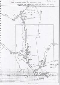
Document - DIAMOND HILL STATE SCHOOL SITE
... History House 11 Mackenzie Street Bendigo goldfields BENDIGO Education diamond hill state school Map (copy) showing the site of Diamond Hill State School, 1873. On top of page 'extracted from Diamond Hill Public Park Reserve ...Map (copy) showing the site of Diamond Hill State School, 1873. On top of page 'extracted from Diamond Hill Public Park Reserve File RS8128, drawn and reproduced at the Department of Lands and Survey, Melbourne'bendigo, education, diamond hill state school -
 Bendigo Historical Society Inc.
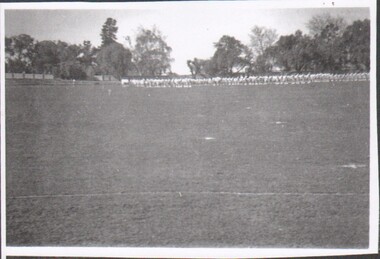
Photograph - Bendigo High School
... History House 11 Mackenzie Street Bendigo goldfields In 1907, the Bendigo Continuation School began and was renamed the Bendigo High School in 1912. Its remit was to provide further education for those wishing to enter the public service, become teachers or attend university. In 1976 it became the first Victorian senior secondary school catering exclusively to Year 11 and 12 students. The phasing out of lower forms was completed by 1979 and in 1984 the school was renamed Bendigo Senior Secondary School. BHS marching Upper Reserve ...In 1907, the Bendigo Continuation School began and was renamed the Bendigo High School in 1912. Its remit was to provide further education for those wishing to enter the public service, become teachers or attend university. In 1976 it became the first Victorian senior secondary school catering exclusively to Year 11 and 12 students. The phasing out of lower forms was completed by 1979 and in 1984 the school was renamed Bendigo Senior Secondary School.B&W photograph of Bendigo High School students marching at the upper reserve, circa 1947.bhs marching, upper reserve -
 Bendigo Historical Society Inc.
Document - PETER ELLIS COLLECTION: NOTES MENTIONING WHIPSTICK REGION
... History House 11 Mackenzie Street Bendigo goldfields BENDIGO Parks and gardens Public Reserves Peter Ellis Collection North/Central L.C.C. ...Four pages of typed notes mentioning the Whipstick Region, Mandurang Forest, Jackass Flat, Diamond Hill Area, One Tree Hill, and the Coliban/Sandhurst Water Supply Reserve. Mentioned are the Birds, Mammals, Geology, Flora, Ground Flora, Orchids,Lilies, Mistletoe, Ferns and Grasses of some of the areas.bendigo, parks and gardens, public reserves, peter ellis collection, north/central l.c.c. region bendigo block, bendigo field naturalists club, shipstick scrub, mandurang forest, one tree hill public park, redvers j eddy, coliban/sandhurst water supply reserve -
 Bendigo Historical Society Inc.
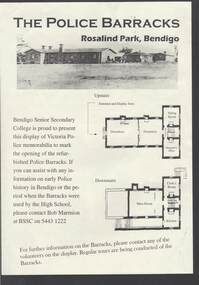
Document - THE POLICE BARRACKS ROSALIND PARK BENDIGO
... History House 11 Mackenzie Street Bendigo goldfields BUILDINGS Government police barracks The Police Barracks Rosalind Park Bendigo Bendigo Senior Secondary College High School Bob Marmion P O Flanagan Public Works Alfred T Snow John Robertson Bendigo Goldfield Bendigo Gaol Bendigo Supreme Court Building Camp Reserve Mounted Constable James 'Tiger' Scholes 6438 Education Department City of Greater Bendigo Graham Bastian Willi Carney Bob Cameron MP Ms Jacinta Allan MP Steve Gibbons MHR Bob Blachford Pale yellow page containing a picture and upstairs and downstairs plans of the Police Barracks, Rosalind Park, Bendigo. ...Pale yellow page containing a picture and upstairs and downstairs plans of the Police Barracks, Rosalind Park, Bendigo. On the back is the history of the building and its use over the years since it was completed in 1860. On the 9 November 2002, the Bendigo Senior Secondary College presented a display of Police memorabilia to mark the opening of the refurbished Police Barracks. There were tours of the Barracks, displays and a Mounted Police display with horses. The Official Party was: Mr Graham Bastian, Principal, Bendigo Senior Secondary College, Mr Bob Cameron MP, member for Bendigo West, Ms Jacinta Allan MP, Member for Bendigo East, Ms Willi Carney, Mayor, City of Greater Bendigo, Mr Steve Gibbons MHR, Member for Bendigo and Mr Rob Blachford. There is a running sheet for the opening.buildings, government, police barracks, the police barracks rosalind park bendigo, bendigo senior secondary college, high school, bob marmion, p o flanagan, public works, alfred t snow, john robertson, bendigo goldfield, bendigo gaol, bendigo supreme court building, camp reserve, mounted constable james 'tiger' scholes 6438, education department, city of greater bendigo, graham bastian, willi carney, bob cameron mp, ms jacinta allan mp, steve gibbons mhr, bob blachford -
 Bendigo Historical Society Inc.
Document - MARKS COLLECTION: MAP OF PARISH OF STRATHFIELDSAYE 1858, 8th September, 1858
... History House 11 Mackenzie Street Bendigo goldfields MAP Bendigo parish of strathfieldsaye 1858 Buff coloured document. On top 'Country Lands, Parish of Strathfieldsaye, County Unnamed'. On bottom 'Scale 40 chains to an inch. Public Lands Office, Melbourne Sept 8th. 1858. William Collis, Lith ( lithographer )'. Map shows Village Reserve ...Buff coloured document. On top 'Country Lands, Parish of Strathfieldsaye, County Unnamed'. On bottom 'Scale 40 chains to an inch. Public Lands Office, Melbourne Sept 8th. 1858. William Collis, Lith ( lithographer )'. Map shows Village Reserve on Emu Creek, road from Sandhurst, Sheepwash Creek and Splitters Creek. Wellington Hotel marked on map near intersection of Sheepwash Creek, Axe Creek and Emu Creek. Axe Creek Pound near Splitters Creek.map, bendigo, parish of strathfieldsaye 1858 -
 Bendigo Historical Society Inc.
Newspaper - PETER ELLIS COLLECTION: NEWSPAPER ARTICLE, 22nd May, 2015
... history,' he said. 'Probably his biggest legacy is the number of young people who have been made aware of bush music and are continuing to play it today and will play it in the future.' As a life member of the Bendigo Field Naturalists Mr Ellis was also involved in campaigns to establish the Whipstick and Kamarooka State Parks and the Saloman's Gully and Jackass Flat Flora Reserves, and lobbied for the inclusion of One Tree Hill in the Greater Bendigo National Park. A public...history,' he said. 'Probably his biggest legacy is the number of young people who have been made aware of bush music and are continuing to play it today and will play it in the future.' As a life member of the Bendigo Field Naturalists Mr Ellis was also involved in campaigns to establish the Whipstick and Kamarooka State Parks and the Saloman's Gully and Jackass Flat Flora Reserves, and lobbied for the inclusion of One Tree Hill in the Greater Bendigo National Park. A public ...Newspaper article from the Bendigo Advertiser stuck on A4 printer paper. Article is dated Friday, May 22, 2015. Article is accompanied by a picture of Peter Ellis and is captioned as such. Article is written by Jason Walls and is titled Loss for folk music history. Article reads: Celebrated Bendigo Music identity, historian and naturalist Peter Ellis OAM died suddenly this week after a brief illness. He was 69. Mr Ellis was highly regarded as a collector and preserver of traditional bush music, with his collection of dance related material the largest in the National Library Archives in Canberra. He was award an Order of Australia Medal in 2012 for services to the arts through the collection and preservation of Australian folk history and heritage. Mr Ellis was a founding member of the Emu Creek Bush Band and achieved two platinum and several gold records in his more than 30 years with the Wedderburn Old Timers Band. Fellow Emu Creek Bush Band member and close friend John Williams said Mr Ellis had made an invaluable contribution to the preservation of Australia's musical and dance heritage, travelling extensively across the country recording and notating folk music. 'In 500 year's time, as long as they can find the technology, people will be able to resurrect our bush dancing history,' he said. 'Probably his biggest legacy is the number of young people who have been made aware of bush music and are continuing to play it today and will play it in the future.' As a life member of the Bendigo Field Naturalists Mr Ellis was also involved in campaigns to establish the Whipstick and Kamarooka State Parks and the Saloman's Gully and Jackass Flat Flora Reserves, and lobbied for the inclusion of One Tree Hill in the Greater Bendigo National Park. A public funeral service will beheld at the Mulqueen Family Chapel on Bridge Street on Monday, May 25, at 11am, followed by a private cremation. An extensive obituary will be published in Saturday's Bendigo Advertiser.person, individual, peter ellis oam -
 Bendigo Historical Society Inc.
Document - VARIOUS ARTICLES FOR SOCIETY NEWSLETTER, DECEMBER 1971
... Bendigo'' - mention of Hill's Open Air Bazaar; ''The Pops'' in the Upper Reserve; the 'Tivoli; the 'Lyseum (sic) ''opposite Lake Weerona''; Wests Pictures in Market Square; the Lyric Theatre; Oscar Flight's orchestra; 4. Handwritten notes (reviews) re book ''Historic Public Buildings of Australia (Cassel - Aust) ''with excellent section on Bendigo'' and book ''These Verdant Plains'' - a history of the Shire of East Loddon (Hawthorn Press); 5. ...Bendigo'' - mention of Hill's Open Air Bazaar; ''The Pops'' in the Upper Reserve; the 'Tivoli; the 'Lyseum (sic) ''opposite Lake Weerona''; Wests Pictures in Market Square; the Lyric Theatre; Oscar Flight's orchestra; 4. Handwritten notes (reviews) re book ''Historic Public Buildings of Australia (Cassel - Aust) ''with excellent section on Bendigo'' and book ''These Verdant Plains'' - a history of the Shire of East Loddon (Hawthorn Press); 5. ...Various articles for Newsletter ('Marunari??) for November???? 1. Re Jack Moorhead (''the most competent engine driver in the Bendigo field'') with handwritten copy of same; 2. 3 pages of handwritten notes for inclusion in the newsletter - various topics; 3. ''The Canons (sic) on Camp Hill'' - history of the Lookout Tower site and flag post, cannons and statue - semi-nude lady - which was damaged in storm and later removed. Source of information for this item attributed to Misses D and D Davenpor, London and the Bendigo Advertiser; handwritten notes re this same article. 4. ''Boys will be boys'' by Mr A Richardson - article based on Annual Report of the Secretary for Mines and Water Supply, 1885 re 11 year old lad who fell down mine; handwritten notes on same article. Various articles for Society newsletter, December 1971; 1. Handwritten note for end of year from President, Neil Murray; 2. Typewritten page titled '' Unknown fate of early diggers'' by W Perry, Eaglehawk; 3. Typewritten article (author - R.A.) re ''The 'Flicks' in (early - deleted?) Bendigo'' - mention of Hill's Open Air Bazaar; ''The Pops'' in the Upper Reserve; the 'Tivoli; the 'Lyseum (sic) ''opposite Lake Weerona''; Wests Pictures in Market Square; the Lyric Theatre; Oscar Flight's orchestra; 4. Handwritten notes (reviews) re book ''Historic Public Buildings of Australia (Cassel - Aust) ''with excellent section on Bendigo'' and book ''These Verdant Plains'' - a history of the Shire of East Loddon (Hawthorn Press); 5. Activities during October (1971?) - typewritten and handwritten copies; 6. Tour report and report on flow of water from the old 'Shamrock' mine, Golden Square - typewritten and handwritten copies; 7. Article re ''Illira'', 57 Forest St, built by Mr Robert Moorhead ca. 1880s, author Mrs B Mullins - handwritten and typewritten copies; 8. Typewritten article describing the ''Bendigo City Market' (handwritten at bottom Mrs Lydia Chancellor, and, Used Dec 1971).document, names of bendigo pioneers -
 Bendigo Historical Society Inc.
Document - VICTORIA HILL - RECOMMENDATION - MINING PROJECT
... History House 11 Mackenzie Street Bendigo goldfields MINE Gold victoria hill Victoria Hill Recommendation - Mining Project Central Nell Gwynne Jack Barker Victoria Hill Area Big 180 Victoria Quartz New Chum Hill (Old Chum Hill) P. M. G. Repeater Station Mine's Department Land's Department Lansell Fortuna A H Q Survey Regiment Lazarus Mine B C V 8 Television Studio Two (a & b) typed copy of a recommendation for mining project, accepted Nov. 1967. Recommendation for Central Nell Gwynne area, now a public purposes reserve ...Two (a & b) typed copy of a recommendation for mining project, accepted Nov. 1967. Recommendation for Central Nell Gwynne area, now a public purposes reserve for preservation as a permanent reminder of the gold mining era. Victoria Hill Area mentioned for it's geographical and historical significance. The New Chum Hill area rich in historical and mining. Notes on development of the Central Nell Gwynne, Victoria Hill and New or Old Chum Hill areas. Notes prepared by Albert Richardson.mine, gold, victoria hill, victoria hill, recommendation - mining project, central nell gwynne, jack barker, victoria hill area, big 180, victoria quartz, new chum hill (old chum hill), p. m. g. repeater station, mine's department, land's department, lansell, fortuna, a h q survey regiment, lazarus mine, b c v 8 television studio -
 Flagstaff Hill Maritime Museum and Village
Functional object - Latch, before 1890
... The identity of the vessel has the potential to change Australia’s history. warrnambool shipwrecked coast flagstaff hill maritime museum shipwreck coast mahogany ship latch relic old warrnambool museum ancient vessel ancient wreck oven latch fireplace latch galley oven Gold ship Gorman's Lane Coastal Reserve Tower Hill Latch, iron. Flat iron latch tapers inward from loop handle to narrow end with prongs. Handmade. Functional object Latch James Gilroy, Public ...Due to the interest of a public works inspector, James Gilroy, who in 1890 dug in the 'ship's remains' of a wreck now known as the Mahogany Ship, Ancient Wreck, Gold Ship, or Ancient Vessel, three relics were located. Two of these objects, a bronze bolt and an iron latch, are part of Flagstaff Hill’s collection of shipwreck artefacts. The third object was a heavily oxidised ‘quantity of ironwork’. - The iron latch was possibly from a galley oven door or fireplace - The bronze bolt, spike or pin Both the bolt and latch are listed on the same page in the records of the Old Warrnambool Museum, and noted that they were found by K.A.G. (or H.A.G.) on the site of the Ancient wreck in 1890. Interestingly, another item in these records is ‘Notes on Ancient wreck, near Gorman’s Lane’. Gorman’s Lane is just inland from the sand dunes of the Coastal Reserve at Tower Hill. The current location of these Notes is unknown. The Museum opened in 1886 and continued until 1963, when it was closed by the Warrnambool City Council and the whole collection was put into storage. The council then transferred items to various places, including Flagstaff Hill and the current Warrnambool Art Gallery. Flagstaff Hill’s early Accession Records book lists the items as being received from the Old Warrnambool Museum collection; the Latch is record 152 and the Pin is record 153. An article, ‘Birthplace of our History’ by Don Dean, is on file in the Warrnambool and District Historical Society. It was published in the Australian POST, on March 17, 1955. This article describes the findings of the items going back to 1890, along with other information about sightings of what has come to be known as the Mahogany Ship. The mystery of the Mahogany Ship began in 1836 when two shipwrecked sealers discovered the remains of an “ancient vessel” in the sand dunes about four miles west of Warrnambool. Since the last recorded sightings in the 1880’s the true origin of the Mahogany Ship has remained one of Australia’s most famous historical mysteries. One of the more recent theories is that the vessel was one of the Portuguese ships exploring the Australian coast in 1522. For over one hundred years, searchers have attempted to locate and identify the wreck. The search continues for the tangible evidence which will once and for all establish the Mahogany Ship’s place in Australia’s History. The latch has local historic significance as it was found in the sand dunes of Warrnambool in 1890. The latch is also significant for being part of the original 1886 Warrnambool Museum's collection. The latch is significant for its possible link to one of Victoria’s and Australia’s maritime mysteries, the Mahogany Ship (also known as the Ancient Wreck). It is one of the very few known relics that could give evidence of the existence and history of the vessel. The ship is listed on the Victorian Heritage Register S438 as it is one of Victoria’s oldest recorded shipwrecks. The identity of the vessel has the potential to change Australia’s history.Latch, iron. Flat iron latch tapers inward from loop handle to narrow end with prongs. Handmade. warrnambool, shipwrecked coast, flagstaff hill maritime museum, shipwreck coast, mahogany ship, latch, relic, old warrnambool museum, ancient vessel, ancient wreck, oven latch, fireplace latch, galley oven, gold ship, gorman's lane, coastal reserve, tower hill -
 Flagstaff Hill Maritime Museum and Village
Functional object - Bolt, before 1890
... The identity of the vessel has the potential to change Australia’s history. warrnambool shipwrecked coast flagstaff hill maritime museum shipwreck coast mahogany ship relic pin spike old warrnambool museum nail ancient vessel ancient wreck portuguese ship Gold Ship Gorman’s Lane Coastal Reserve Tower Hill Bolt, also referred to as spike or pin. Bronze bolt, round body with head on one end that has straight sides, tapers to a point at the other end. Functional object Bolt James Gilroy, Public ...Due to the interest of a public works inspector, James Gilroy, who in 1890 dug in the 'ship's remains' of a wreck now known as the Mahogany Ship, Ancient Wreck, Gold Ship, or Ancient Vessel, three relics were located. Two of these objects, a bronze bolt and an iron latch, are part of Flagstaff Hill’s collection of shipwreck artefacts. The third object was a heavily oxidised ‘quantity of ironwork’. - The iron latch was possibly from a galley oven door or fireplace - The bronze bolt, spike or pin Both the bolt and latch are listed on the same page in the records of the Old Warrnambool Museum, and noted that they were found by K.A.G. (or H.A.G.) on the site of the Ancient wreck in 1890. Interestingly, another item in these records is ‘Notes on Ancient wreck, near Gorman’s Lane’. Gorman’s Lane is just inland from the sand dunes of the Coastal Reserve at Tower Hill. The current location of these Notes is unknown. The Museum opened in 1886 and continued until 1963, when it was closed by the Warrnambool City Council and the whole collection was put into storage. The council then transferred items to various places, including Flagstaff Hill and the current Warrnambool Art Gallery. Flagstaff Hill’s early Accession Records book lists the items as being received from the Old Warrnambool Museum collection; the Latch is record 152 and the Pin is record 153. An article, ‘Birthplace of our History’ by Don Dean, is on file in the Warrnambool and District Historical Society. It was published in the Australian POST, on March 17, 1955. This article describes the findings of the items going back to 1890, along with other information about sightings of what has come to be known as the Mahogany Ship. The mystery of the Mahogany Ship began in 1836 when two shipwrecked sealers discovered the remains of an “ancient vessel” in the sand dunes about four miles west of Warrnambool. Since the last recorded sightings in the 1880’s the true origin of the Mahogany Ship has remained one of Australia’s most famous historical mysteries. One of the more recent theories is that the vessel was one of the Portuguese ships exploring the Australian coast in 1522. For over one hundred years, searchers have attempted to locate and identify the wreck. The search continues for the tangible evidence which will once and for all establish the Mahogany Ship’s place in Australia’s History. The bolt has local historic significance as it was found in the sand dunes of Warrnambool in 1890. The bolt is also significant for being part of the original 1886 Warrnambool Museum's collection. The bolt is significant for its possible link to one of Victoria’s and Australia’s maritime mysteries, the Mahogany Ship (also known as the Ancient Wreck). It is one of the very few known relics that could give evidence of the existence and history of the vessel. The ship is listed on the Victorian Heritage Register S438 as it is one of Victoria’s oldest recorded shipwrecks. The identity of the vessel has the potential to change Australia’s history.Bolt, also referred to as spike or pin. Bronze bolt, round body with head on one end that has straight sides, tapers to a point at the other end.warrnambool, shipwrecked coast, flagstaff hill maritime museum, shipwreck coast, mahogany ship, relic, pin, spike, old warrnambool museum, nail, ancient vessel, ancient wreck, portuguese ship, gold ship, gorman’s lane, coastal reserve, tower hill -
 Ringwood and District Historical Society
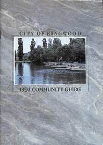
Book, City of Ringwood, City of Ringwood 1992 Community Guide, 1992
... CONTENTS: (page no.) 1991/92 COUNCIL REPRESENTATIVES 4 1992 CALENDAR 51 AQUATIC CENTRE 8 AQUATIC CENTRE VOUCHERS 49 CHIEF EXECUTIVE'S REPORT 6 CIVIC CENTRE TELEPHONE INDEX — DIRECT DIALLING 53 COMMUNITY DIRECTORY 35-47 COMMUNITY SERVICES 17-19 COUNCIL & COMMITTEE CYCLES 4 COUNCIL FINANCES & 1991/92 RATES 16 COUNCILLORS 3 FUNCTIONAL RESPONSIBILITIES 15 HISTORY OF RINGWOOD 5 HOUSING & RESIDENTIAL DEVELOPMENT 29-30 INFRASTRUCTURE 34 LOCAL, STATE & FEDERAL GOVERNMENT ELECTIONS 32 MANAGEMENT TEAM 14 MAYORAL MESSAGE – Cr. Max Williams 1 NEIGHBOURHOOD MAP 26-27 NOTES 52 PAPER & CARDBOARD COLLECTION SERVICE 22 PARKS & RESERVES — PUBLIC FACILITIES 31 PROTECTING OUR COMMUNITY 23-24 PROTECTING THE ENVIRONMENT 20-21 RINGWOOD FESTIVAL & HIGHLAND CARNIVAL 13 RINGWOOD GOLF COURSE 7 STRATEGIC BIKE PLAN 11 STREET INDEX A-L 25 STREET INDEX L-Z 28 THE LIBRARY 12 THE RINGWOOD CONVENTION & PERFORMING ARTS CENTRE 10 TRAFFIC MANAGEMENT 33 YOUR PERSONAL DIRECTORY 50 ...Ringwood and District Historical Society 125A Warrandyte Road Ringwood North melbourne rinx CONTENTS: (page no.) 1991/92 COUNCIL REPRESENTATIVES 4 1992 CALENDAR 51 AQUATIC CENTRE 8 AQUATIC CENTRE VOUCHERS 49 CHIEF EXECUTIVE'S REPORT 6 CIVIC CENTRE TELEPHONE INDEX — DIRECT DIALLING 53 COMMUNITY DIRECTORY 35-47 COMMUNITY SERVICES 17-19 COUNCIL & COMMITTEE CYCLES 4 COUNCIL FINANCES & 1991/92 RATES 16 COUNCILLORS 3 FUNCTIONAL RESPONSIBILITIES 15 HISTORY OF RINGWOOD 5 HOUSING & RESIDENTIAL DEVELOPMENT 29-30 INFRASTRUCTURE 34 LOCAL, STATE & FEDERAL GOVERNMENT ELECTIONS 32 MANAGEMENT TEAM 14 MAYORAL MESSAGE – Cr. Max Williams 1 NEIGHBOURHOOD MAP 26-27 NOTES 52 PAPER & CARDBOARD COLLECTION SERVICE 22 PARKS & RESERVES — PUBLIC FACILITIES 31 PROTECTING OUR COMMUNITY 23-24 PROTECTING THE ENVIRONMENT 20-21 RINGWOOD FESTIVAL & HIGHLAND CARNIVAL 13 RINGWOOD GOLF COURSE 7 STRATEGIC BIKE PLAN 11 STREET INDEX A-L 25 STREET INDEX L-Z 28 THE LIBRARY 12 THE RINGWOOD CONVENTION & PERFORMING ARTS CENTRE 10 TRAFFIC MANAGEMENT 33 YOUR PERSONAL DIRECTORY 50 Community information book issued by City of Ringwood for 1992 - covering the facilities and activities of the Ringwood Council and other local organisations and associations. ...Community information book issued by City of Ringwood for 1992 - covering the facilities and activities of the Ringwood Council and other local organisations and associations. Includes two Aquatic Centre entry vouchers valid until June 30th, 1992.CONTENTS: (page no.) 1991/92 COUNCIL REPRESENTATIVES 4 1992 CALENDAR 51 AQUATIC CENTRE 8 AQUATIC CENTRE VOUCHERS 49 CHIEF EXECUTIVE'S REPORT 6 CIVIC CENTRE TELEPHONE INDEX — DIRECT DIALLING 53 COMMUNITY DIRECTORY 35-47 COMMUNITY SERVICES 17-19 COUNCIL & COMMITTEE CYCLES 4 COUNCIL FINANCES & 1991/92 RATES 16 COUNCILLORS 3 FUNCTIONAL RESPONSIBILITIES 15 HISTORY OF RINGWOOD 5 HOUSING & RESIDENTIAL DEVELOPMENT 29-30 INFRASTRUCTURE 34 LOCAL, STATE & FEDERAL GOVERNMENT ELECTIONS 32 MANAGEMENT TEAM 14 MAYORAL MESSAGE – Cr. Max Williams 1 NEIGHBOURHOOD MAP 26-27 NOTES 52 PAPER & CARDBOARD COLLECTION SERVICE 22 PARKS & RESERVES — PUBLIC FACILITIES 31 PROTECTING OUR COMMUNITY 23-24 PROTECTING THE ENVIRONMENT 20-21 RINGWOOD FESTIVAL & HIGHLAND CARNIVAL 13 RINGWOOD GOLF COURSE 7 STRATEGIC BIKE PLAN 11 STREET INDEX A-L 25 STREET INDEX L-Z 28 THE LIBRARY 12 THE RINGWOOD CONVENTION & PERFORMING ARTS CENTRE 10 TRAFFIC MANAGEMENT 33 YOUR PERSONAL DIRECTORY 50 rinx -
 Coal Creek Community Park & Museum
Bottle, glass, Post 1916 - c.1939
... RESERVE,) at 12 o'clock, AN INVOICE of Drawings, Prints, Crayons, Portraits, coloured Figures II M. Ships '"Vindictive," "Victory," "Pomona," ''Vanguard," " Carysfoot," " Magicienne," &c., coloured ; the Channel Fleet, Jenny Lind, and a large quantity of Engravings. Three hundred volumes Books, comprising Novels, History, Poetry, School Books, &c., &c., &c. A large quantity of assorted stationery consisting of boxes of India rubber bands, pens, show cases, fancy wafers, satin note paper. One cask Stephen's Fluid Ink, in pints and half-pints. Terms— Cash'. TROVE : The Argus (Melbourne, Vic. : 1848 - 1957) Tuesday 27 March 1956 p 2 Advertising 'PUBLIC...RESERVE,) at 12 o'clock, AN INVOICE of Drawings, Prints, Crayons, Portraits, coloured Figures II M. Ships '"Vindictive," "Victory," "Pomona," ''Vanguard," " Carysfoot," " Magicienne," &c., coloured ; the Channel Fleet, Jenny Lind, and a large quantity of Engravings. Three hundred volumes Books, comprising Novels, History, Poetry, School Books, &c., &c., &c. A large quantity of assorted stationery consisting of boxes of India rubber bands, pens, show cases, fancy wafers, satin note paper. One cask Stephen's Fluid Ink, in pints and half-pints. Terms— Cash'. TROVE : The Argus (Melbourne, Vic. : 1848 - 1957) Tuesday 27 March 1956 p 2 Advertising 'PUBLIC ...TROVE : Port Philip Gazette and Settler's Journal (Vic. : 1845 - 1850) Saturday 21 April 1849 p 3 Advertising 'On MONDAY, 23RD INSTANT, (WITHOUT RESERVE,) at 12 o'clock, AN INVOICE of Drawings, Prints, Crayons, Portraits, coloured Figures II M. Ships '"Vindictive," "Victory," "Pomona," ''Vanguard," " Carysfoot," " Magicienne," &c., coloured ; the Channel Fleet, Jenny Lind, and a large quantity of Engravings. Three hundred volumes Books, comprising Novels, History, Poetry, School Books, &c., &c., &c. A large quantity of assorted stationery consisting of boxes of India rubber bands, pens, show cases, fancy wafers, satin note paper. One cask Stephen's Fluid Ink, in pints and half-pints. Terms— Cash'. TROVE : The Argus (Melbourne, Vic. : 1848 - 1957) Tuesday 27 March 1956 p 2 Advertising 'PUBLIC NOTICE TO BOTTLERS, BOTTLE DEALERS. Etc., RE PROPERTY BRANDED BOTTLES WHICH ARE NOT SOLD The undermentioned Firms and Companies,' carrying on businesses at Sydney and elsewhere, HEREBY GIVE NOTICE that all Bottles delivered by them to their customers having: a notification moulded thereon (including bottom) that they are, or remain the property of. the Firms and Companies mentioned below ARE NOT SOLD WITH THE CONTENTS THEREOF BUT REMAIN THE PROPERTY OF SUCH FIRMS AND COMPANIES. Such Bottles are loaned solely for the purpose of enabling the contents to be delivered to purchasers from the said Firms and 'Companies and to all subsequent purchasers of the contents. As soon as the Bottles are emptied of their contents they must not be refilled destroyed, damaged, or used again for any purpose, but must, on demand be delivered up to the Companies or Firms whose names are moulded thereon or to their Accredited Agents: BUTLER & NORMAN PTY. LTD., MANDIBLE STREET. ALEXANDRIA, N.S.W. The remuneration received by Collectors, Dealers, etc.,- is simply an allowance for the safe custody and collection of the Bottles LEGAL ACTION WILL BE TAKEN AGAINST ANY PERSON OR COMPANY VIOLATING THE PROPERTY RIGHTS OF THESE FIRMS OR COMPANIES' BRANDED BOTTLES. ABC Mop Co.......................Stephens Ink (Australia) Pty Ltd.......................'.Squat round clear glass ink bottle with embossed text on heel at base and monogram on base'PROPERTY OF STEPHENS INKS AUSTRALIA LTD' on heel of base. Austrralian Glass Manufacturers monogram on base with embossed illustration of a feather quill.ink bottle -
Ballarat Tramway Museum
Document, Hector Bell Junior, "Street passenger transport system of Geelong Urban Area", 1949
... Ballarat Tramway Museum South Gardens Reserve Wendouree Parade Ballarat Ballarat goldfields Report by Hector H Bell Junior of the MMTB early 1949, titled "Street passenger transport system of Geelong Urban Area". Looks at the history of public ...Report by Hector H Bell Junior of the MMTB early 1949, titled "Street passenger transport system of Geelong Urban Area". Looks at the history of public transport in Geelong, tramway data, financial analysis, the Geelong bus system, buses servicing the North Shore industries - principally the Ford Works, the condition of the bus fleet, taxi and private car hire services, functions of a street transport authority, town planning, populations and traffic surveys, relative values of passenger vehicles, trolley buses, industry and recommendations. Said the tramway system was obsolete, should be a rail service between North and South Geelong, set up a street transport body, replan the Geelong railway station, additional roads to service the North Shore area. Refers to attachments. Has a list of people involved in the preparation of the report. See item 112 for the AETA response of April 1949 to this report.Yields information about the Geelong tram and bus services in 1948/49 and how it could be developed or reformed. Has a close association with Hector Bell Junior, the son of the then MMTB Chairman.Document - 18 foolscap sheets photocopied and stapled in three places along the side.tramways, secv, geelong, statistics, history, passenger services, reports, aeta -
 Ballarat Tramway Museum
Newspaper, Basil Silcove, "What you always wanted to know about Trams", 3/10/1971
... Ballarat Tramway Museum South Gardens Reserve Wendouree Parade Ballarat Ballarat goldfields Newspaper clipping with an article written by Basil Silcove titled "What you always wanted to know about Trams" featuring a photo of Ballarat 36 in Melbourne after the close of the Ballarat system, and a European (Tatra?) PCC type tram. Article looks at the history of trams around the world, Melbourne, tramcar production in Europe and public ...Newspaper clipping with an article written by Basil Silcove titled "What you always wanted to know about Trams" featuring a photo of Ballarat 36 in Melbourne after the close of the Ballarat system, and a European (Tatra?) PCC type tram. Article looks at the history of trams around the world, Melbourne, tramcar production in Europe and public transport in General. On the rear has the Melbourne TV programmes.Yields information about the history of trams around the world.Newspaper sheet - torn from the Sunday News 3/10/1971.tramways, closure, europe, tram 36, new tramcars