Showing 37 items matching "hopkins point"
-
 Kew Historical Society Inc
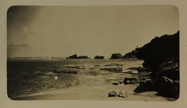
Photograph - Mouth of the Hopkins River, Point Ritchie, Warrnambool, c.1926
... Mouth of the Hopkins River, Point Ritchie, Warrnambool......Hopkins River...Point...The location in this photograph has been identified by Kathleen Gervasoni as the mouth of the Hopkins River, Point Ritchie, Warrnambool. ...The location in this photograph has been identified by Kathleen Gervasoni as the mouth of the Hopkins River, Point Ritchie, Warrnambool. Photograph Mouth of the Hopkins River, Point Ritchie, Warrnambool ...Henry Beater Christian (1886-1962) , was a descendant of one of the earliest settler families in Kew. Employed at the Kew Asylum as a 'public servant', he was a skilled amateur photographer, photographing numerous scenes in Kew and on his travels around Victoria. The majority of his photographs date from 1916 to 1929. His finest photographs are housed in two photograph albums. Digital copy of a photograph from page 23 of the 47-page photograph album containing 261 gelatinous silver images, loaned by Diane Washfold with permission given to digitise and hold a copy in our collection. Henry Christian took a number of walking and rail trips, individually or with friends, around regional and rural Victoria during the 1920s. This photo is from a series of twelve photographs of parts of the west coast of Victoria, including Port Fairy and Warrnambool. The location in this photograph has been identified by Kathleen Gervasoni as the mouth of the Hopkins River, Point Ritchie, Warrnambool. henry beater christian (1886-1962), landscape photography, christian-washfold collection, photograph albums, hopkins river, point ritchie, warrnambool -
 Warrnambool and District Historical Society Inc.
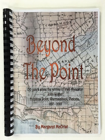
Booklet, Beyond the Point, 2007
... ...hopkins point...They lived at Hopkins Point, Warrnambool and the book, ‘Beyond the Point’ tells the story of the Logan descendants. ...Front Cover: ‘Beyond the Point, 150 years since the arrival of Irish ancestor, John Logan, Hopkins Point, Warrnambool, Victoria, 1857-2007, by Margaret McOrist’. ...They lived at Hopkins Point, Warrnambool and the book, ‘Beyond the Point’ tells the story of the Logan descendants. ...This book was written in 2007 by Margaret McOrist to mark the 150th anniversary of the arrival in the Warrnambool area of John Logan. It is a sequel to a 1991 book, ‘Clotted Cream and Mangels’ which told the story of John Logan and his wife Mary Gardner. They lived at Hopkins Point, Warrnambool and the book, ‘Beyond the Point’ tells the story of the Logan descendants. When the farm land was sub-divided and sold the nearby beach was named ‘Logans Beach’. This book is of considerable interest as it tells the story of the descendants of important early settlers, John Logan and Mary Gardner. The area where they first settled is now of major interest as Logans Beach (named for the Logan family) is the well-known whale watching area. Southern Right Whales return to this beach each year and the females calve and remain up to three months at this beach, making it an important ‘whale nursery’. This is a soft cover book with black plastic ring binding and clear plastic sheets covering the front and back paper covers. The front cover has a reproduction of an 1891 map of Warrnambool and district with the title of the book and other information superimposed on the map. The back cover is black. The book has 101 pages and contains information on the Logan families who lived at Tooram in Allansford and their descendants. There are many black and white and colour photographs, diagrams, maps and family trees. Front Cover: ‘Beyond the Point, 150 years since the arrival of Irish ancestor, John Logan, Hopkins Point, Warrnambool, Victoria, 1857-2007, by Margaret McOrist’. john logan and mary gardner, hopkins point, logans beach, tooram, history of warrnambool -
 Warrnambool and District Historical Society Inc.
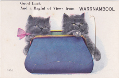
Postcard - Views of Warrnambool
... ...hopkins falls...thunder point...Pictures depicting scenes of Warrnambool & District. 9 pictures are, The Beach. Hopkins River. Thunder Point. Liebig St. Botanical Gardens. ...Warrnambool and District Historical Society Inc. 2 Gilles Street (south of Merri St) Warrnambool great-ocean-road Pictures depicting scenes of Warrnambool & District. 9 pictures are, The Beach. Hopkins River. Thunder Point. Liebig St. Botanical Gardens. ...Pictures depicting scenes of Warrnambool & District. 9 pictures are, The Beach. Hopkins River. Thunder Point. Liebig St. Botanical Gardens. Breakwater and pier. Hopkins River. Soldiers Memorial. Hopkins Falls.A typical souvenir postcard from the 1930'sOblong postcard with flip down views of Warrnambool from a purse with two kittensValentine's Mail Novelty Post Card; Good Luck And a Bagful of Views from WARRNAMBOOLwarrnambool, hopkins river, warrnambool breakwater, warrnambool postcards, postcards, hopkins falls, thunder point, soldiers memorial -
 Ballarat Heritage Services
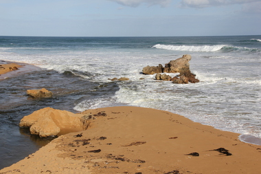
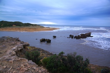
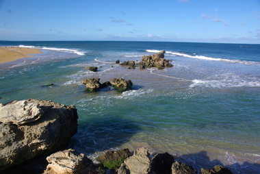
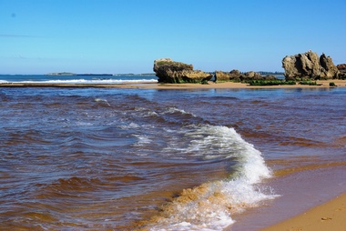
Digital photographs, L.J. Gervasoni, Hopkins River Mouth, c2010 - 2017
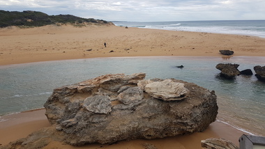
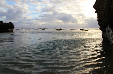
... hopkins river...mouth...point...Ballarat Heritage Services PO Box 2209 Bakery Hill Post Office goldfields hopkins river mouth point ritchie bluehole warrnambool coast coastal beach seascape Three colour photographs of the mouth of the Hopkins River at Warrnambool. ...Three colour photographs of the mouth of the Hopkins River at Warrnambool.hopkins river, mouth, point ritchie, bluehole, warrnambool, coast, coastal, beach, seascape -
 Ballarat Heritage Services
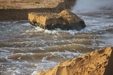
Digital photographs, L.J. Gervasoni, Hopkins River Mouth blocked, c2010 - 2017
... hopkins river...mouth...point...Ballarat Heritage Services PO Box 2209 Bakery Hill Post Office goldfields hopkins river mouth point ritchie bluehole warrnambool coast coastal beach seascape blocked Hopkins River Mouth blocked Digital photographs L.J. ...hopkins river, mouth, point ritchie, bluehole, warrnambool, coast, coastal, beach, seascape, blocked -
 Ballarat Heritage Services
Digital photographs, L.J. Gervasoni, Hopkins River Mouth blocked, c2010 - 2017
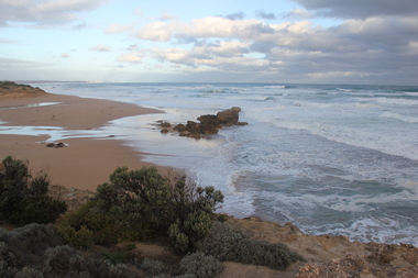
... hopkins river...mouth...point...Ballarat Heritage Services PO Box 2209 Bakery Hill Post Office goldfields hopkins river mouth point ritchie bluehole warrnambool coast coastal beach seascape blocked Colour photograph of the blocked mouth of the Hopkin's River at Warrnambool. ...Colour photograph of the blocked mouth of the Hopkin's River at Warrnambool.hopkins river, mouth, point ritchie, bluehole, warrnambool, coast, coastal, beach, seascape, blocked -
 Ballarat Heritage Services
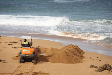
Photograph - Digital photographs, L.J. Gervasoni, Hopkins River Mouth blocked - channel digger, c2010 - 2017
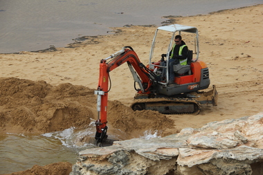
... hopkins river...mouth...point...Ballarat Heritage Services PO Box 2209 Bakery Hill Post Office goldfields hopkins river mouth point ritchie bluehole warrnambool coast coastal beach seascape blocked digger opening mouth mechanical opening Colour photograph of the blocked mouth of the Hopkins River being opened by a channel digger. ...Colour photograph of the blocked mouth of the Hopkins River being opened by a channel digger. hopkins river, mouth, point ritchie, bluehole, warrnambool, coast, coastal, beach, seascape, blocked, digger, opening mouth, mechanical opening -
 Ballarat Heritage Services
Digital photographs, L.J. Gervasoni, Hopkins River Mouth blocked - artificial channel, c2010 - 2017
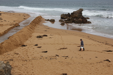
... hopkins river...mouth...point...Ballarat Heritage Services PO Box 2209 Bakery Hill Post Office goldfields hopkins river mouth point ritchie bluehole warrnambool coast coastal beach seascape blocked digger opening mouth mechanical opening Colour photograph of an artificial chanel in the blocked mouth of the Hopkins River, Warrnambool. ...Colour photograph of an artificial chanel in the blocked mouth of the Hopkins River, Warrnambool. hopkins river, mouth, point ritchie, bluehole, warrnambool, coast, coastal, beach, seascape, blocked, digger, opening mouth, mechanical opening -
 Ballarat Heritage Services
Digital photographs, L.J. Gervasoni, Hopkins River Mouth blocked - artificial channel, c2010 - 2017
... hopkins river...mouth...point...Ballarat Heritage Services PO Box 2209 Bakery Hill Post Office goldfields hopkins river mouth point ritchie bluehole warrnambool coast coastal beach seascape blocked digger opening mouth mechanical opening Colour photograph of an rtificial chanel at the mouth of the Hopkin's River, Warrnambool. ...Colour photograph of an rtificial chanel at the mouth of the Hopkin's River, Warrnambool. hopkins river, mouth, point ritchie, bluehole, warrnambool, coast, coastal, beach, seascape, blocked, digger, opening mouth, mechanical opening -
 Ballarat Heritage Services
Digital photographs, L.J. Gervasoni, Hopkins River Mouth blocked - artificial channel - sand falling in, c2010 - 2017
... hopkins river...mouth...point...Ballarat Heritage Services PO Box 2209 Bakery Hill Post Office goldfields hopkins river mouth point ritchie bluehole warrnambool coast coastal beach seascape blocked digger opening mouth mechanical opening Hopkins River Mouth blocked - artificial channel - sand falling in Digital photographs L.J. ...hopkins river, mouth, point ritchie, bluehole, warrnambool, coast, coastal, beach, seascape, blocked, digger, opening mouth, mechanical opening -
 Ballarat Heritage Services
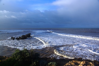
Photograph - Digital photographs, L.J. Gervasoni, Hopkins River Mouth in flood, c2010 - 2017
... hopkins river...mouth...point...Ballarat Heritage Services PO Box 2209 Bakery Hill Post Office goldfields hopkins river mouth point ritchie bluehole warrnambool coast coastal beach seascape flood The flooded Hopkins River flows into the sea at Warrnambool. ...The flooded Hopkins River flows into the sea at Warrnambool.hopkins river, mouth, point ritchie, bluehole, warrnambool, coast, coastal, beach, seascape, flood -
 Ballarat Heritage Services
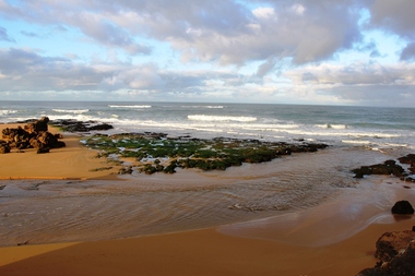
Digital photographs, L.J. Gervasoni, Hopkins River Mouth reef exposed after flood, c2010 - 2017
... hopkins river...mouth...point...Ballarat Heritage Services PO Box 2209 Bakery Hill Post Office goldfields hopkins river mouth point ritchie bluehole warrnambool coast coastal beach seascape flood post flood reef exposed geology coastal geomorphology Hopkins River Mouth reef exposed after flood Digital photographs L.J. ...hopkins river, mouth, point ritchie, bluehole, warrnambool, coast, coastal, beach, seascape, flood, post flood, reef, exposed, geology, coastal geomorphology -
 Ballarat Heritage Services
Digital photographs, L.J. Gervasoni, Hopkins River Mouth in flood as the waters receed, c2010 - 2017
... hopkins river...mouth...point...Ballarat Heritage Services PO Box 2209 Bakery Hill Post Office goldfields hopkins river mouth point ritchie bluehole warrnambool coast coastal beach seascape flood post flood geology coastal geomorphology waters receeding Colour photograph of the mouth of the Hopkins River at Warrnambool, Hopkins River Mouth in flood as the waters receed Digital photographs L.J. ...Colour photograph of the mouth of the Hopkins River at Warrnambool,hopkins river, mouth, point ritchie, bluehole, warrnambool, coast, coastal, beach, seascape, flood, post flood, geology, coastal geomorphology, waters receeding -
 Ballarat Heritage Services
Digital photographs, L.J. Gervasoni, Hopkins River Mouth in flood - waters receeding, c2010 - 2017
... hopkins river...mouth...point...Ballarat Heritage Services PO Box 2209 Bakery Hill Post Office goldfields hopkins river mouth point ritchie bluehole warrnambool coast coastal beach seascape flood post flood geology coastal geomorphology waters receeding Hopkins River Mouth in flood - waters receeding Digital photographs L.J. ...hopkins river, mouth, point ritchie, bluehole, warrnambool, coast, coastal, beach, seascape, flood, post flood, geology, coastal geomorphology, waters receeding -
 Ballarat Heritage Services
Digital photographs, L.J. Gervasoni, Hopkins River Mouth after the flood, c2010 - 2017
... hopkins river...mouth...point...Ballarat Heritage Services PO Box 2209 Bakery Hill Post Office goldfields hopkins river mouth point ritchie bluehole warrnambool coast coastal beach seascape flood post flood geology coastal geomorphology waters receeding Hopkins River Mouth after the flood Digital photographs L.J. ...hopkins river, mouth, point ritchie, bluehole, warrnambool, coast, coastal, beach, seascape, flood, post flood, geology, coastal geomorphology, waters receeding -
 Ballarat Heritage Services
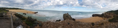
Digital photographs, L.J. Gervasoni, Hopkins River Mouth - panorama, c2010 - 2017
... hopkins river...mouth...point...Ballarat Heritage Services PO Box 2209 Bakery Hill Post Office goldfields hopkins river mouth point ritchie bluehole warrnambool coast coastal beach seascape coastal geomorphology pano Colour photograph of the mouth of the Hopkin's River at Warrnambool, Victoria. ...Colour photograph of the mouth of the Hopkin's River at Warrnambool, Victoria. hopkins river, mouth, point ritchie, bluehole, warrnambool, coast, coastal, beach, seascape, coastal geomorphology, pano -
 Ballarat Heritage Services
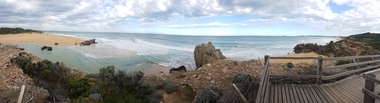
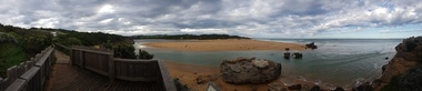
Digital photographs, L.J. Gervasoni, Hopkins River Mouth - panorama, c2010 - 2017
... hopkins river...mouth...point...Ballarat Heritage Services PO Box 2209 Bakery Hill Post Office goldfields hopkins river mouth point ritchie bluehole warrnambool coast coastal beach seascape coastal geomorphology pano Panoramic photograph of the mouth of the Hopkin's River at Warrnambool. ...Panoramic photograph of the mouth of the Hopkin's River at Warrnambool.hopkins river, mouth, point ritchie, bluehole, warrnambool, coast, coastal, beach, seascape, coastal geomorphology, pano -
 Ballarat Heritage Services
Digital photographs, L.J. Gervasoni, Hopkins River Mouth - panorama, c2010 - 2017
... hopkins river...mouth...point...Ballarat Heritage Services PO Box 2209 Bakery Hill Post Office goldfields hopkins river mouth point ritchie bluehole warrnambool coast coastal beach seascape coastal geomorphology pano Colour photograph of the mouth of the Hopkins River, Warrnambool. ...Colour photograph of the mouth of the Hopkins River, Warrnambool.hopkins river, mouth, point ritchie, bluehole, warrnambool, coast, coastal, beach, seascape, coastal geomorphology, pano -
 Ballarat Heritage Services
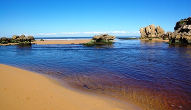
Digital photographs, L.J. Gervasoni, Hopkins River Mouth - double channel post flood, c2010 - 2017
... hopkins river...mouth...point...Ballarat Heritage Services PO Box 2209 Bakery Hill Post Office goldfields hopkins river mouth point ritchie bluehole warrnambool coast coastal beach seascape coastal geomorphology Hopkins River Mouth - double channel post flood Digital photographs L.J. ...hopkins river, mouth, point ritchie, bluehole, warrnambool, coast, coastal, beach, seascape, coastal geomorphology -
 Ballarat Heritage Services
Digital photographs, L.J. Gervasoni, Hopkins River Mouth - blocked - mechanical digger, c2010 - 2017
... hopkins river...mouth...point...Ballarat Heritage Services PO Box 2209 Bakery Hill Post Office goldfields hopkins river mouth point ritchie bluehole warrnambool coast coastal beach seascape coastal geomorphology Hopkins River Mouth - blocked - mechanical digger Digital photographs L.J. ...hopkins river, mouth, point ritchie, bluehole, warrnambool, coast, coastal, beach, seascape, coastal geomorphology -
 Warrnambool and District Historical Society Inc.
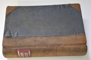
Administrative record - Bakery Ledger, Andrew Jack, Dyson & Co., Melbourne, Baker's Ledger, 1940s
... The bakery served many nearby areas including Wangoom, Hopkins Point, Cudgee, Mepunga, Naringal and Lake Glllear. ...The bakery served many nearby areas including Wangoom, Hopkins Point, Cudgee, Mepunga, Naringal and Lake Glllear. ...This ledger comes from the Model Bakery business of G.W. Greaves, a baker and pastrycook In Allansford in the first half of the 20th century. Allansford is a township 10 kilometres east of Warrnambool, now incorporated into the City of Warrnambool. The ledger contains details of the Greaves business sales of goods, mostly bread, from 1946 to 1948 and includes the names of the customers, the orders and the moneys owing. The bakery served many nearby areas including Wangoom, Hopkins Point, Cudgee, Mepunga, Naringal and Lake Glllear. This ledger is of interest as it illustrates the size of the Allansford bakery and contains many names of people in the area in the 1940s, making it a valuable research object.This is a ledger with a black cover and leather coverings at the corners and a brown leather spine. The red label on the spine has gold lettering and ornamental edges. The inside of the cover has a red mottled pattern and has tape and string stitching. A maker's label is also inside the front cover. The pages are ruled with red lines and contain handwritten entries. There are some loose invoices. The cover is very faded and stained.Baker's Ledger Andrew Jack, Dyson & Co. Wholesale Stationersallansford bakery, greaves model bakery -
 Warrnambool and District Historical Society Inc.
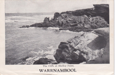
Postcard - Strip Card photos of Warrnambool, Mid 20th century
... ‘The Cliffs at Shelley Point’, ‘Hopkins Falls’. ...‘The Cliffs at Shelley Point’, ‘Hopkins Falls’. This is a series of 15 black and white postcards of views of Warrnambool folded into a packet originally designed to be sent by mail but the cover is missing. ...These types of folding postcards, showing scenes and buildings in Australian towns, were mass produced for tourists in the 1930s, 40s and 50s and later. Many similar cards of Warrnambool views have survived today. These commercial photographs are of minor interest as there are many other copies available. They show what tourists were buying 60 or 70 years ago and give us some idea of what Warrnambool streets and tourist spots looked like at that time. This is a series of 15 black and white postcards of views of Warrnambool folded into a packet originally designed to be sent by mail but the cover is missing. The photographs have a white background. The word ‘Warrnambool’ is on the front card. Each card has a title eg. ‘The Cliffs at Shelley Point’, ‘Hopkins Falls’. warrnambool, tourism -
 Warrnambool and District Historical Society Inc.
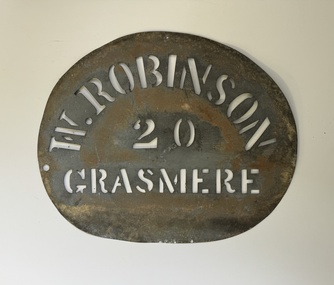
Functional object - Robinson Farm Labelling Stencil, c.1950
... James Robinson came to Australia in 1857 and he and his family farmed at Springvale at Hopkins Point, then at what was termed 'Manning's old Purnim Farm' on the Merri Rive at Grasmere (the Manning brothers, Frederick and John were early farmers in the district). ...James Robinson came to Australia in 1857 and he and his family farmed at Springvale at Hopkins Point, then at what was termed 'Manning's old Purnim Farm' on the Merri Rive at Grasmere (the Manning brothers, Frederick and John were early farmers in the district). ...This stencil has been made to label packaged produce (wool bales, packaged meat etc) from a farm in Grasmere, near Warrnambool. The name, W. Robinson, suggests that this is William Robinson the son of James and Jane Robinson. James Robinson came to Australia in 1857 and he and his family farmed at Springvale at Hopkins Point, then at what was termed 'Manning's old Purnim Farm' on the Merri Rive at Grasmere (the Manning brothers, Frederick and John were early farmers in the district). The Robinson brothers, James and Stuart were well-known in the Warrnambool district as champion ploughmen. James's son, William married firstly Christina MacLennan and then Elizabeth Neale of Tooram, Allansford. William died in 1959 but the stencil was probably used on the property after his death. This farm stencil is of interest as a memento of farming at Grasmere in the first half of the 20th century.This is a metal stencil, oval in shape. It has letters cut out in the metal for stencilling purposes. It has been painted or sprayed and is rusted in places.W. Robinson 20 Grasmerewilliam robinson grasmere, manning's purnim farm -
 Warrnambool and District Historical Society Inc.
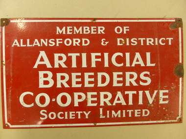
Plaque, Artificial Breeders Co-operative, Circa 1965
... These included Michael Melican (Wangoom), Gerald Mugavin (Wollaston), Noel Garner (Hopkins Point), Jim Halford (Naringal East) and Grant Warnock (Southern Cross). ...These included Michael Melican (Wangoom), Gerald Mugavin (Wollaston), Noel Garner (Hopkins Point), Jim Halford (Naringal East) and Grant Warnock (Southern Cross). ...The Allansford Artificial breeders was commenced in 1960 As a business its main focus was on the improvement of local herds for local farmers.As a result of 32 district farmers meeting at the Allansford Mechanics Hall, the Allansford & District Artificial Breeders Co-operative Society was formed. The subscription for membership was £7 10s. The meeting was instigated through the efforts of Noel Garner, a Hopkins Point farmer, who was manager of No.1 and No.2 Warrnambool Herd Testing Associations, and Gethan Fenton, a field officer with the Warrnambool Herd Testing Association. Bill Quinlan, who had been a herd tester under Noel Garner’s management, became the first employee of the Artificial Breeders. WCB support was available from the beginning as a room was provided behind the factory offices and the AI fees were collected by the factory from suppliers’ milk cheques. In the first 12 months Bill worked alone with some assistance from Russell Learmonth and Roger Walsh, both Kraft employees. Both factories realised the benefits of herd improvement in view of their overall increased production so membership was encouraged. Semen from the best sires in Canada and New Zealand were made available and farmers also could soon see the benefits. The initial board of directors, unlike WCB beginnings, consisted entirely of farmers. These included Michael Melican (Wangoom), Gerald Mugavin (Wollaston), Noel Garner (Hopkins Point), Jim Halford (Naringal East) and Grant Warnock (Southern Cross). Membership grew rapidly and after one year there were 164 members with another 100 joining the following year. After a year of coping alone Bill was joined by Ray Eccles from Purnim and then Pat Gleeson, later a Warrnambool car dealer. John Fitzgerald became a part-time technician. These signs were attached to the entrance gates of users. In the mid 1970s it became known as the Warrnambool Co-operative and while it maintained a strong rural and farming focus a opened a retail store in Warrnambool in Timor Street in the 1970's which became the largest trading department store in the district. By the late 1990s they had 8000 members and employed 84 full time and 120 casual staff. It met a sorry end in the 2000's.This sign is a link to a business which had a large exposure in the latter part of the 20th Century. As such it has social and historical significance. Rectangular metal sign, painted red with white text and white border around the edge. Screw holes in corners. Member of Allansford & district Artificial Breeders Co-operative Society Limited allansford artificial breeders, warrnambool co-operative society limited -
 Flagstaff Hill Maritime Museum and Village
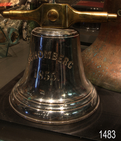
Functional object - Bell, Schomberg 1855, Before 1855
... Their journey eventually led them to the home of settler John Manning, located at Hopkins Point near Warrnambool. Manning took possession of the bells and subsequently presented them to two churches in Warrnambool. ...Their journey eventually led them to the home of settler John Manning, located at Hopkins Point near Warrnambool. Manning took possession of the bells and subsequently presented them to two churches in Warrnambool. ...The Rescue and Journey of the Schomberg Bells: This bell was the smaller of two rescued by the crew of the Schomberg following the ship’s wreck in 1855. While the specific purpose of the smaller bell is unknown, it may have served to assemble the crew or signal mealtimes on board. After surviving the shipwreck, the crew carried both bells as they made their way along the coastline. Their journey eventually led them to the home of settler John Manning, located at Hopkins Point near Warrnambool. Manning took possession of the bells and subsequently presented them to two churches in Warrnambool. The smaller bell went to St Joseph’s Catholic Church, while the larger bell went to St John’s Presbyterian Church. After around a year, the small bell at St Joseph’s developed a crack and became unusable. Thomas Manifold imported a replacement bell for the church, and the damaged bell was stored at his farm. Years later, when the property was sold to John Logan, the discarded bell was donated to the old Warrnambool Museum upon its opening in 1886. The Curator, Joseph Archibald, placed the bell on display in the entry. In 1975, it was transferred from the Warrnambool Art Gallery to Flagstaff Hill. The ’Mystery’ of the small bell solved: Despite numerous attempts by the staff at Flagstaff Hill to restore the bell’s lustre, the bell remained dull and tarnished. In October 1986, Director Peter Ronald decided to send the bell for professional advice. The bell was entrusted to Briggs Marine Products, a renowned brass founder established in 1912. Upon examination, the specialists at Briggs discovered the reason behind the bell’s persistent lack of shine: it had originally been silver-plated, but most of the plating had worn away over time. The experts at Briggs then undertook the task of restoring the bell, successfully returning it to a gleaming silver surface. The Sailing Ship Schomberg: Launched in 1855, the Schomberg was regarded as the “Noblest” ship afloat at the time. Owned by the Black Ball Line, it was built for their passenger fleet by Alexander Hall of Aberdeen at a cost of £43,103. The construction featured three skins: one planked fore and aft and two diagonally planked, all fastened with screw-threaded trunnels (wooden rails). The ship’s First Class accommodation was luxurious, boasting velvet pile carpets, large mirrors, rosewood, birds-eye maple and mahogany timbers, satin damask soft furnishings, and an oak-lined library with a piano. Schomberg had a capacity for 1,000 passengers. The ship’s master, Captain James Nicol Forbes—also known as ‘Bully’ Forbes—was only 34 years old at the launch. He had a reputation for setting and breaking speed records on the Black Ball Line’s Marco Polo and Lightning. In 1852, Forbes completed the London to Melbourne journey on the Marco Polo in 68 days, a record at the time, though 53 passengers died during the voyage. In 1854, he sailed the Lightning to Melbourne in 76 days and returned in only 63 days—a record that stood among sailing ships. Forbes was known for driving his ship and crew to their limits, often prioritising speed over passenger comfort. Determined to set new records, he promised to reach Melbourne in sixty days, declaring he would do so “with or without the help of God.” The Maiden Voyage and the Wreck: Schomberg departed Liverpool on 6th October 1855, flying a banner that read “Sixty Days to Melbourne”. The vessel carried 430 passengers and 3,000 tons of cargo, including materials to build the Melbourne to Geelong Railway and a bridge over the Yarra River. Among the cargo were a cow for fresh milk, pens for fowls and pigs, and 90,000 gallons of water for drinking and washing. Additionally, it transported 17,000 letters and 31,800 newspapers. The ship and cargo were insured for $300,000, a considerable sum for the era. Poor winds while crossing the equator delayed Schomberg’s progress. Land was first sighted on Christmas Day at Cape Bridgewater near Portland. Captain Forbes followed the coastline towards Melbourne, but was reportedly playing cards when the third mate, Henry Keen, reported land only three miles away. The ship ran aground on a sand spit near Curdie’s Inlet (approximately 56 km west of Cape Otway) on 26th December 1855, after 78 days at sea. The sand spit and nearby currents were not marked on Forbes’s map. During the night, the crew launched a lifeboat to search for a safe landing spot for the passengers. The scouting party advised Forbes to wait until morning, as rough seas posed a danger to the lifeboats. At dawn, the ship’s Chief Officer spotted the SS Queen and signalled for help. The master of the Queen brought his vessel alongside, and all passengers and crew disembarked safely. The Black Ball Line’s Melbourne agent sent another steamer to collect the passengers’ baggage, and other steamers assisted with cargo salvage until worsening weather forced operations to cease. Notably, a plunderer later recovered a case of Wellington boots, but all were for the left foot. The wreck and its cargo were sold to local merchants Manifold & Bostock, who did not attempt further salvage. They later sold their interest to a Melbourne businessman and two seafarers. In 1864, after two men drowned in their attempt to reach the Schomberg, salvage efforts were abandoned. By 1870, parts of the ship had washed ashore on New Zealand’s South Island. Today, the wreck is about nine metres below the surface. Although most woodwork has disintegrated, the vessel’s shape remains discernible due to the railway irons, girders, and framework. Various goods and materials from the ship are scattered nearby. The bell is particularly significant in that along with other items from the wreck helped in part to having the legislation changed to protect shipwrecks, with far tighter controls being employed to oversee the salvaging of wreck sites. This bell forms part of the Schomberg collection at Flagstaff Hill maritime museum. The collection as a whole is of historical and archaeological significance at a State level. Flagstaff Hill’s collection of artefacts from the Schomberg is also significant for its association with the Victorian Heritage Registered Schomberg shipwreck (VHR S 612). The collection is of additional significance because of the relationship between the objects salvaged, as together they help us to interpret the story of the Schomberg. The collection as a whole is historically significant for representing aspects of Victoria's maritime history and its potential to interpret social and historical themes from society at the time of the wreck. A small ship’s bell. The silver-plated metal bell bears the ship’s name and year of construction on one side and the name and address of the ship’s builders on the other. These details are deeply engraved into the metal and formed in bold, upper-case lettering. The bell has two bell stands: the left and the right. Both stands have an Iron pipe bent into an inverted ‘Y’ shape, with a hole along its length and feet attached to a rectangular metal plate at the other two ends. Feet are bolted to a timber base that has a hole drilled through the centre for mounting. Bell's front; “SCHOMBERG” with “1855” below. Bell's back “HALL & SONS (crack splits letter “N”) / BUILDERS (in italics) / ABERDEEN” (crack splits letter “B”).flagstaff hill, flagstaff hill maritime museum and village, warrnambool, maritime museum, maritime village, great ocean road, shipwreck coast, schomberg, silver plated bell, mess bell, bell stands, captain ‘bully’ forbes, alexander hall and son, james baines and company, liverpool’s black ball line, bell, schomberg bell, ship's bell, small bell, st joseph's church, briggs marine, john manning, john logan, warrnambool museum, briggs foundry, silver bell -
 Warrnambool and District Historical Society Inc.
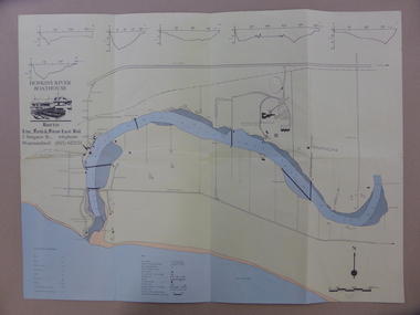
Map - An Angler's map of the Hopkins River Estuary, Angler's map Hopkins River, 1980s
... The Hopkins River Estuary has been a focal point for fishermen throughout Warrnambool’s history. warrnambool anglers’ club history of warrnambool Hopkins River Hopkins River Estuary John sherwood This is a sheet of paper folded three times to produce a folded map. ...This is a map of the Hopkins River Estuary prepared by Dr John Sherwood for the benefit of anglers. The information on the sheet includes the location of sand banks, the water depths, boat ramp facilities and public access facilities. Some of the information has been gathered from aerial photographs. The map has been produced by the Warrnambool Institute of Advanced Education which was developed in the late 1960s from the tertiary section of the Warrnambool Technical College and with all its departments established by 1984 at the Sherwood Campus five kilometres from Warrnambool on the Princes Highway. Today the site is occupied by Deakin University, Warrnambool campus. The Warrnambool Anglers’ Club has its headquarters on the banks of the Hopkins River near the mouth of the river and the Lyndoch Aged Care facility.This map is of interest as a specialist one, providing fishermen with detailed information on all aspects of the Hopkins river estuary. Fishing has been both a profession and a popular recreational pursuit for Warrnambool residents since the early days of the city’s settlement. The Hopkins River Estuary has been a focal point for fishermen throughout Warrnambool’s history. This is a sheet of paper folded three times to produce a folded map. The front cover has a black and white photograph of two fishermen with a large fish. The map of the Hopkins River Estuary is in yellow, blue and black and covers the side of one sheet and three quarters of the other side. There is an advertisement for the Hopkins River Boathouse with a black and white sketch of the boathouse and notes on the map written by Dr John Sherwood. There are several diagrams showing the water depths. The map has some silverfish damage and some tearing at the folds. warrnambool anglers’ club, history of warrnambool, hopkins river, hopkins river estuary, john sherwood -
 Warrnambool and District Historical Society Inc.
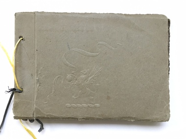
Book, Scrap Book, Circa 1930
... This album contains photographs of many local and beach scenes such as view over Warrnambool, Botanic Gardens, Hopkins River and Bridge, Warrnambool railway station, Proudfoots, Thunder Point, Christ Church and the War Memorial. ...Warrnambool and District Historical Society Inc. 2 Gilles Street (south of Merri St) Warrnambool great-ocean-road This album contains photographs of many local and beach scenes such as view over Warrnambool, Botanic Gardens, Hopkins River and Bridge, Warrnambool railway station, Proudfoots, Thunder Point, Christ Church and the War Memorial. ...This album contains photographs of many local and beach scenes such as view over Warrnambool, Botanic Gardens, Hopkins River and Bridge, Warrnambool railway station, Proudfoots, Thunder Point, Christ Church and the War Memorial. There are a couple of photographs of groups of people picnicking on the main beach. The newspaper cutting showing firemen dousing the last of the flames of the fire has onlookers including four children in the foreground. The Ozone Coffee Palace was built in 1890-1891 and burnt down February23, 1929. It was one of the largest fires in Warrnambool It was designed by Mr J McLeod. It was grand in design and decoration. The term Coffee Palace was used to describe temperance hotels which were built during the 1880’s -1890’s. They typically were multi-purpose and had a large number of rooms for ballrooms and leisure activities. Coffee palaces were aimed at families in coastal areas and inner city locations. Examples of some are The Windsor Hotel Melbourne, Ozone, Queenscliff and Kilbreda Convent in Mentone. This album has social and historical significance as it shows a collection of local scenes which is a record of familiar scenes such as the gardens, Hopkins River and beach scenes. The groups of people are unknown but the images provide a snapshot of customs and costumes of the early 1920’s.Khaki coloured soft card tied with a dark green cord which has broken and has been replaced with yellow string. There is an embossing of a lion/dragon on front cover with ribbons. 20 pages with photographs glued to most. A cutting relating to the fire at the Ozone mansions is inside the front cover.warrnambool history, early warrnambool photographs, ozone coffee palace -
 Warrnambool and District Historical Society Inc.
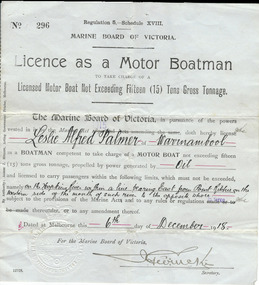
Document, Licence Motor boatman, 1918
... Written material: ‘Leslie Alfred Palmer of Warrnambool, oil, on the Hopkins River within a line bearing east from Point Ritchie on the western side of the mouth of such river to the opposite shore, 6th December 1918’ ...Motor Boat Licence 1918 Warrnambool Leslie Palmer Hopkins River Written material: ‘Leslie Alfred Palmer of Warrnambool, oil, on the Hopkins River within a line bearing east from Point Ritchie on the western side of the mouth of such river to the opposite shore, 6th December 1918’ This is a paper licence issued by the Marine Board of Victoria in 1918. ...This is a licence issued to Leslie Palmer in 1918. It gives him authority to operate a motor boat across the banks of the Hopkins River near the mouth and to carry passengers. As there is a bridge at the mouth of the river it is assumed that this motor boat was used to go across the river from a private house, making it more convenient than going by road to cross the bridge. It was, and still is, a common practice to use boats to cross the river from private homes built along the banks of the Hopkins River.This is a significant item as it is an original certificate and is interesting because the licence was a restricted one, for use only in crossing the Hopkins River. This is a paper licence issued by the Marine Board of Victoria in 1918. The certificate has printed material and entries written in black ink. It has the seal of the Marine Board and the signature of the SecretaryWritten material: ‘Leslie Alfred Palmer of Warrnambool, oil, on the Hopkins River within a line bearing east from Point Ritchie on the western side of the mouth of such river to the opposite shore, 6th December 1918’ motor boat licence 1918, warrnambool, leslie palmer, hopkins river -
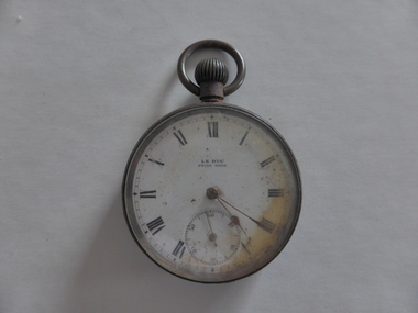 Warrnambool and District Historical Society Inc.
Watch, Watch from Nestor
... Hopkins River in 1921. This was one of the great tragic incidents in Warrnambool in the early 20th century nestor sinking norman borthwick constable sharrock ‘Le Duc, Swiss made’ This is a Swiss-made watch made of gunmetal with a glass face and a metal winder at the top and a ring to attach the watch to a chain. The figures are Roman numerals and there is a separate minute hand dial. The watch is much rusted and is not able to be easily opened to see the mechanism. The gold-coloured hands point ...This watch belonged to Norman Borthwick of Ecklin, who, with his wife and two children, Janet, aged 7 and Jack, aged 6, were survivors of the sinking of the cruise boat, Nestor, on the Hopkins River in January 1921. The boat was on its regular trip from the Hopkins River boatsheds to Jubilee Park with 80 passengers. Ten people were drowned when the boat began to take water and sank about a kilometre upstream. Norman Borthwick was wearing the watch at the time and the hands have stopped at 5.20 p.m. on the day of the tragedy. A hero of the day was Constable Sharrock who drowned after saving the lives of several of those on boardThis watch is of great significance as it is an item that belonged to Norman Borthwick who was wearing the watch when he survived the sinking of the Nestor in the Hopkins River in 1921. This was one of the great tragic incidents in Warrnambool in the early 20th centuryThis is a Swiss-made watch made of gunmetal with a glass face and a metal winder at the top and a ring to attach the watch to a chain. The figures are Roman numerals and there is a separate minute hand dial. The watch is much rusted and is not able to be easily opened to see the mechanism. The gold-coloured hands point to the time of 20 past 5. The face of the watch is discoloured on the right hand side.‘Le Duc, Swiss made’nestor sinking, norman borthwick, constable sharrock -
 Flagstaff Hill Maritime Museum and Village
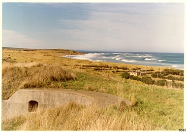
Photograph - Historical, Flagstaff Hill, Warrnambool Garrison Fortifications looking towards the Moyjil (Point Ritchie), 1970s
... HOPKINS / This is the original site of one of the cannons overlooking the Bay. Access to this area could be between the light-houses (throught the cottage grounds), or a service entrance - past the iron huts used by Lands Department." Coloured photograph, glassy print, one of a set of five. Photograph shows the original site of one of the gun emplacements for the cannons, cannons Historical, looking towards the Moyjil, ,Point ...The photograph shows the location of the concrete, horseshoe shaped gun emplacement erected for the cannons. It is part of the Historic Precinct on Flagstaff Hill. The area was accessed either through the space between the Lighthouses (through the cottage grounds) or a service entrance, past the iron huts used by the Lands Department. This photograph, a print, is one of a set of five that show the site of Flagstaff Hill. It is presumed to have been taken by John Lindsay, Founding Director of Flagstaff Hill Maritime Museum and Village. One of the photographs in the set has the pencil inscription "Photo J Lindsay". It was taken in the early 1970s during the initial stages of the development of Flagstaff Hill as a Museum and Maritime Village. The photographs belonged to the donor's grandparents, who lived in the Warrnambool district of Allansford/Naringal. The photograph is a record of the site and surrounds of Flagstaff Hill Maritime Museum and Village before its development and opening in 1975. It shows the east side of the Surfside Holiday Park in its earlier days. The photograph is significant for recording the location and condition of the original concrete cannon emplacement on the Hill.Coloured photograph, glassy print, one of a set of five. Photograph shows the original site of one of the gun emplacements for the cannons, cannons Historical, looking towards the Moyjil, ,Point Ritchie and overlooking Lady Bay, Warrnambool. The horseshoe shaped concrete gun emplacement is in the foreground on the grassed slopes overlooking the Bay. The site and ablution block of the Surfside Holiday Park is centre right. The left shows the sore of Lady Bay with the cliffs of the Southern Ocean in the distance. The photograph's paper has the printer's watermark on the back. The early 1970s scene is presumed to have been photographed by John Lindsay, Warrnambool.Label on the back: "FIRST GUN EMPLACEMENT LOOKING TOWARDS THE HOPKINS / This is the original site of one of the cannons overlooking the Bay. Access to this area could be between the light-houses (throught the cottage grounds), or a service entrance - past the iron huts used by Lands Department."flagstaff hill, flagstaff hill maritime museum and village, warrnambool, maritime museum, maritime village, great ocean road, shipwreck coast, 1970s, photograph, gun emplacement, surfside holiday park, lady bay, hopkins river, flagstaff hill site, john lindsay, concrete gun emplacement, cannon emplacement, original emplacement