Showing 6 items matching "kerrit bareet"
-
 Ballan Shire Historical Society
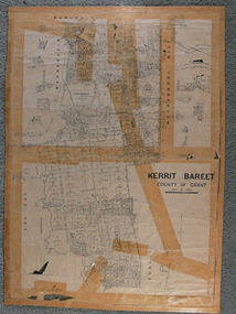
Map - Map. Kerrit Bareet, Department of Lands and Survey, Kerrit Bareet. County of Grant, 08/1944
... Map. Kerrit Bareet....Kerrit Bareet. County of Grant.......kerrit bareet...A map of the Kerrit Bareet area within the County of Grant showing properties and names of owners in 1944....A map of Kerrit Bareet in the County of Grant. Black printing on buff coloured paper. ...Shows a Scale in Chains and Price 2/. Kerrit Bareet. County of Grant. Map Map. Kerrit Bareet. ...A map of the Kerrit Bareet area within the County of Grant showing properties and names of owners in 1944.Significant to people researching land usage and ownership. Also those researching families in the area at that time.A map of Kerrit Bareet in the County of Grant. Black printing on buff coloured paper. Details roads, rivers, railways, property boundaries and names of property owners and towns and villages. The map is easily readable although there is some physical damage and that and the borders have been reinforced with sellotape. Shows a Scale in Chains and Price 2/.gordon, bungal, kerrit bareet, lal lal, moorarbool river, warrenheip, bungaree, wallace, moorarbool west -
 Federation University Historical Collection
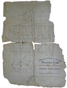
Plan, Eugene Bellairs, Moorabool Creek, Parish of Kerrit-Bereet, 01/08/1855
... ...Kerrit-Bareet...Barker Library (top floor) Mount Helen goldfields Moorabool Kerrit-Bareet moorabool creek eugene bellairs Plan of the Moorabool Creek on the Melbourne Road Moorabool Creek, Parish of Kerrit-Bereet Plan Eugene Bellairs J.B. ...Plan of the Moorabool Creek on the Melbourne Roadmoorabool, kerrit-bareet, moorabool creek, eugene bellairs -
 Federation University Historical Collection
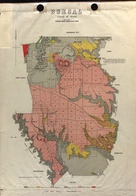
Map - Plan, E.J. Dunn, Bungal County of Grant Parish Plan
... ...Kerrit Bareet...Dunn was the surveyor of this parish plan. plan bungal bungeltap black horse co. egerton egerton mount egerton sister rose shaft south learmonth co Kerrit Bareet Bungaeeltap Yaloak Eastern Moorabool River Corong Bungal Station Preemptive Right Lal Lal Western Moorabool River Moorabool Rover Borhoneychurck Mount Egerton Battery Bungal Creek Colour geological plan of Bungal in the County of Grant, Victoria. ...E.J. Dunn was the surveyor of this parish plan.Colour geological plan of Bungal in the County of Grant, Victoria. The areas circled in red ar craters.plan, bungal, bungeltap, black horse co. egerton, egerton, mount egerton, sister rose shaft, south learmonth co, kerrit bareet, bungaeeltap, yaloak, eastern moorabool river, corong, bungal station preemptive right, lal lal, western moorabool river, moorabool rover, borhoneychurck, mount egerton battery, bungal creek -
 Ballan Shire Historical Society
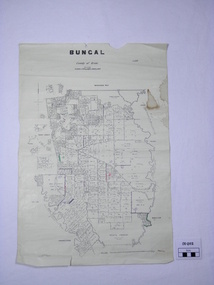
Map - Map. Bungal, Department of Lands and Survey, Bungal, County of Grant, 09/09/1926
... ...kerrit bareet...It shows the roads and the Western and Eastern Moorarbool River, and the Whipstick State Forest. bungal kerrit bareet egerton lal lal borhoneyghurk bungeeltap ballark yaloak gorong moorarbool west Coloured pen marks and circled numbers on various areas. ...A map of Bungal in the 1920's showing the allotments, and the size, with the names of the residents. It shows the roads and the Western and Eastern Moorarbool River, and the Whipstick State Forest.Cream coloured map of Bungal in the County of Grant, bounded by the the East Moorarbool River on the East, and the State Forest on the South. It is marked with the scale of chains and the number L.358. Lithographed at the Department of Lands and Survey. Melbourne by W. J. Butson on 9.9.1926. It shows the land allotments with names of owners.Coloured pen marks and circled numbers on various areas. Price 2 shillings marked on bottom right hand edge.bungal, kerrit bareet, egerton, lal lal, borhoneyghurk, bungeeltap, ballark, yaloak, gorong, moorarbool west -
 Ballan Shire Historical Society
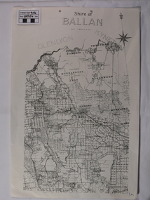
Map - Map. Shire of Ballan, Shire of Ballan
... ...kerrit bareet...Ballan Shire Historical Society 45-47 Steiglitz St Ballan goldfields This is a fairly comprehensive map of the former Shire of Ballan which is now amalgamated into the Shire of Moorabool. gordon ballan bungal kerrit bareet borhoneyghurk bungeeltap ballark yaloak gorong beremboke wallace ingliston hunterston millbrook bradshaw myrniong blackwood moorarbool greendale bayup trentham bullarto korweinguboora glenlyon bolwarra A black and white map of the Shire of Ballan showing major roads, rivers, towns, settlements, State parks and forests and land subdivisions. ...This is a fairly comprehensive map of the former Shire of Ballan which is now amalgamated into the Shire of Moorabool.A black and white map of the Shire of Ballan showing major roads, rivers, towns, settlements, State parks and forests and land subdivisions. It appears to be a copy of the original as no dates or maker or printer appear on the map. There is a scale of 2 miles to 1 inch.gordon, ballan, bungal, kerrit bareet, borhoneyghurk, bungeeltap, ballark, yaloak, gorong, beremboke, wallace, ingliston, hunterston, millbrook, bradshaw, myrniong, blackwood, moorarbool, greendale, bayup, trentham, bullarto, korweinguboora, glenlyon, bolwarra -
 Federation University Historical Collection
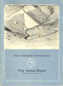
Book, Exchange Press Pty Ltd, West Moorabool Water Board First Annual Report For The Year Ended 30th June 1969, 1969
... ...kerrit bareet...Lal Lal gordon bungaree wallace lal lal kerrit bareet buninyong bungal lal lal reservoir Bungal dam Mt egerton Hopwoods Hill gordon fiskens Hill green hill mt buninyong clarendon R.G. ...Documents the concept, construction and management of the Bungal dam built on the West Moorabool River in 1972 to safeguard the water supplies of Geelong and Ballarat. Provides details of the history, the West Morrabool Water Board and its members, the Act and finances.BookInk on paperlal lal, gordon, bungaree, wallace, lal lal, kerrit bareet, buninyong, bungal, lal lal reservoir, bungal dam, mt egerton, hopwoods hill, gordon, fiskens hill, green hill, mt buninyong, clarendon, r.g. biggs, w.f. stephen, r.a. horsfall, w.a. borthwick, t.m. conroy, sir henry bolte, west moorabool water board