Showing 679 items matching "land surveys"
-
 Bendigo Historical Society Inc.
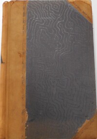
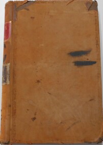
Document - LANDS OFFICE - CROWN LANDS SURVEYED AND SOLD SANDHURST - 1857 - 1879, 1857 - 1879
... ... land surveys...Contains details of crown land surveyed and sold, district of Sandhurst. ...Contains details of crown land surveyed and sold, district of Sandhurst. ...Journal: black hard cover with buff spine and corners. Contains details of crown land surveyed and sold, district of Sandhurst. Double pages numbered on top right, page columns - parish, town lands, particulars, survey fees, date of survey, date of sale, auction, selection price per acre, total amount, purchaser. No index. On spine '08' 'Bendigo A' 26th June 1857 to 1879 (?)Lands Officeplace, land sales, lands office, crown land, land surveys, bendigo, sandhurst -
 Bendigo Historical Society Inc.
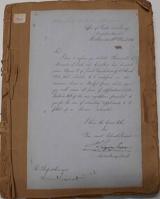
Document - LAND AND SURVEY CIRCULARS 1876 - 1883, 1876 - 1883
... LAND AND SURVEY CIRCULARS 1876 - 1883...... land surveys...Document: land and survey circulars - brown paper covered journal tied with string along spine. ...History House 11 Mackenzie Street Bendigo goldfields ORGANIZATION Bendigo Sandhurst land sales land surveys Office of Lands and Survey Document: land and survey circulars - brown paper covered journal tied with string along spine. ...Document: land and survey circulars - brown paper covered journal tied with string along spine. On front cover top LH corner '04A' Stuck to front cover is blue foolscap handwritten letter from Office of Lands and Survey (Occupation Branch) Melbourne 15th. March 1876. Journal contains copies of letters signed by District Surveyor, Sandhurst.Office of Lands and Surveyorganization, bendigo, sandhurst, land sales, land surveys -
 Warrnambool and District Historical Society Inc.
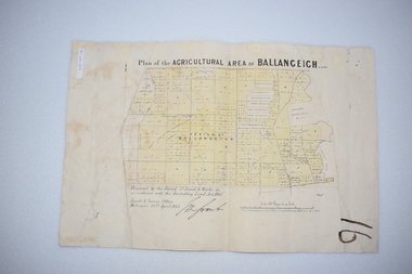
Original Document, Map: Agricultural area of Ballangeich 1865, 1865
... ...Land surveys Victoria 1865...At the top: Plan of the Agricultural area of Ballangeich 1865 At the bottom left: Prepared by the Board of Lands & Works in accordance with the Amending Land Act 1865 Lands & Survey Office Melbourne 13th April 1865. ...This map is typical of many which were produced in the 1860's in Victoria during a significant period of Victoria's and Warrnambool district history. history of warrnambool ballangeich Land surveys Victoria 1865 Lands Act 1865 Victoria Ballangeich map 1865 At the top: Plan of the Agricultural area of Ballangeich 1865 At the bottom left: Prepared by the Board of Lands & Works in accordance with the Amending Land Act 1865 Lands & Survey Office Melbourne 13th April 1865. ...George Eddington arrived in Australia in 1839 and named and established property in 1841 calling the property Ballangeich after a Pass near his home town of Stirling in Scotland. It is situated 151 miles west of Melbourne and to the south of Mortlake and was originally part of the Mortlake shire, which was proclaimed 26th Jan 1864. Nearest streams are the Hopkins Riverand Lyall and Drysdale creek running through good agricultural land. This map relates to the breaking up of large runs which the Victorian government enabled through selection acts of the 1860's. The previously larger runs which were mainly cattle and sheep based were now more open to closer settlement and a greater variety in farming.The lots range in size from approximately 50 acres to around 600 acres.Some areas are set aside for reserves. By 1886 the population of Ballangeich had grown to around 600 with an hotel, three state schools and a church.Tri weekly coaches ran to Colac, Warrnambool and Camperdown providing access to supplies mail and communication. This map is typical of many which were produced in the 1860's in Victoria during a significant period of Victoria's and Warrnambool district history.Rectangular light card paper with black text showing allotments of land The area is coloured in green with scale at bottom right cornerAt the top: Plan of the Agricultural area of Ballangeich 1865 At the bottom left: Prepared by the Board of Lands & Works in accordance with the Amending Land Act 1865 Lands & Survey Office Melbourne 13th April 1865. With signaturehistory of warrnambool, ballangeich, land surveys victoria 1865, lands act 1865 victoria, ballangeich map 1865 -
 Glen Eira Historical Society
Map - CAPLES PLACE SUBDIVISION
... ... Land Surveys...Land Subdivisions Documents Maps Glen Eira CAPLES PLACE CAPLES PLACE Subdivision Land Surveys Orrong Road Mulgrave Road Prahran Grove Somerset Road Prahran Grove Prahran Grove East Walk Land Allotments Town Planning Garden Road Map CAPLES PLACE SUBDIVISION ...This file contains a copy of a map of the CAPLES PLACE SUBDIVISION, undated and author unknown. The map provides the dimensions of roads and allotments in the area, including also handwritten notes from the original document and others written directly onto the copy.land subdivisions, documents, maps, glen eira, caples place, caples place subdivision, land surveys, orrong road, mulgrave road, prahran grove, somerset road, prahran grove, prahran grove, east walk, land allotments, town planning, garden road -
Glen Eira Historical Society
Document - Historic Conservation Areas Project
... Survey... Town Planning... Heritage Studies... Rodda Andrew... City of Caulfield... Housing Estates... Victoria National Estate Grants Program... Australia Icomos... Burra Charter... Buildings Structures and Establishments... Land...Ford Hazel Preliminary Conservation Survey Town Planning Heritage Studies Rodda Andrew City of Caulfield Housing Estates Victoria National Estate Grants Program Australia Icomos Burra Charter Buildings Structures and Establishments Land Surveys Suburbs Historic Buildings Architectural Significance ‘Caulfield’s Heritage Study’ Soloman Geulah Dr. ...Contains 4 items relating to historic conservation: 1/Five newsletters (one page each newsletter, dated 07/1975, 08/1975, 09/1975, 10/1975 and the final one 12/1975) describing how the project evolved, project funds, progress, study method, project 1 report, project 2 report and summary as no further funds available. Project was to include all of Melbourne but funding did not allow this. Note: newsletters stamped with Caulfield Historical Society. 2/Letter (one page on official city of Caulfield letterhead) from Andrew Rodda (manager planning) to Hazal Ford (dated 13/11/1989) describing ‘council resolved on 18/07/1989 to proceed with preliminary conservation survey’ and mentions that a copy is included. 3/Preliminary conservation survey for the City of Caulfield (nine pages) describing background, study area, budget, purpose, study outline, timeframe, report format, ownership, tasks and background information (mentions number and types of houses and properties as at 1986 and 1988) and a map of City of Caulfield. 4/Booklet (28 pages) titled ‘Heritage Area – Caulfield North Draft Heritage Guidelines July 1999 – City of Glen Eira’, containing Caulfield North Heritage Area, cultural heritage, Heritage Overlay Area, architectural description, common architectural forms and features, development guidelines, key design checklist. It includes a map of the Caulfield North Heritage Overlay Area, two illustrations about the development envelope and many black-and-white photographs of houses and architectural features.historic conservation areas project niven barbara, newsletters, town planning, historic buildings, heritage studies, housing, royal historical society of victoria (rhsv), read michael, plans, local government, historical societies, committee for urban action (cua), national trust, hopkins sherry ms., ford hazel, preliminary conservation survey, town planning, heritage studies, rodda andrew, city of caulfield, housing estates, victoria national estate grants program, australia icomos, burra charter, buildings structures and establishments, land surveys, suburbs, historic buildings, architectural significance, ‘caulfield’s heritage study’, soloman geulah dr., caulfield library, dandenong road, nepean highway, hotham street, iknerman road, orrong road, north road, poath road, ‘plan of the city of caulfield’, north ward, east ward, south ward, west ward, kooyong road, neerim road, bambra road, balaclava road, shire of caulfield, railways, world war 1914-1918, depression 1929-1939, rippon lea, labassa, parks, mansions, community services, ‘caulfield north draft heritage guidelines july 1999’, city of glen eira, caulfield north heritage area, glen eira heritage management plan, mayfield grove, normanby avenue, carnarvon street, glenferrie street, arthur street, malakoff street, normanby road, heritage advisory service, construction materials, victorian style, mediterranean style, spanish mission style, californian bungalow style, federation style, architectural style, architectural features, heritage conservation design, building construction, building regulations, aboriginal peoples, carnarvon road -
Glen Eira Historical Society
Article - Watts, William Cowley
... ... Land surveys...Watts and Sons Shire of Caulfield Drainage Irrigation sewerage Sanitation Land surveys Royal Society Mansion Retail trade Merchants Station Place Watts James S Murray Street "Whybe" Article Watts, William Cowley ...This file contains four items about William Cowley Watts, brother of Thomas Henry Watts:. 1/ Photocopy of two articles from newspapers on one page. One entitled "Portait for the Mayoral Gallery" (Caulfield Contact 01/09/1988) relates to a portrait of William Cowley Watts, who was the Shire President of Caulfield in 1876 and 1883, being added to Council's memorial gallery of Mayors. The other entitled "GLENHUNTLY-steeped in history" (Southern Cross 18/06/1986) states that the history of the suburb Glenhuntly is derived from the house Glen Huntly built in 1855 as the home of Thomas Watts. It was the first architect designed house in Caulfield. A black and white photograph of the house with Thomas Watts' family is included in the Southern Cross article. The house was named after the ship Glen Huntly which travelled from Scotland to Port Phillip Bay arriving 7 April 1840 2/ Research notes (2 pages) on the Watts family of Caulfield being one line of info (likely from rate books but unsourced and undated) giving 1874 details of a property in Orrong Road for William Cowley Watts on one page; plus a separate page with one line of information (unsourced and undated) giving 1910 Directory information for James S Watts architect at "Whybe" Murray St E. south side. 3/ An A4 typed article about William Cowley Watts which is similar but not the same as the Caulfield Contact article above. 4/ A photocopy combining a photo of a head and shoulders portrait of a man with handwritten notes identifying him as William Cowley Watts (1839-1883), Shire President of Caulfield, City Surveyor of Melbourne.watts william cowley, watts thomas henry, shire president, councillors, caulfield, monuments, memorials, portrait, gallery of mayors, city offices, architects, architecture, national trust, victorian institute of architects, city surveyor of melbourne, drainage system, watts charles george, caulfield grammar school, fellow of the federal institute of accountants, city treasurer of melbourne, watts geoffrey, glen huntly, glenhuntly, glenhuntly traders association, caulfield city council, huntly street, grange road, glenhuntly road, watts john, watts mary, thos. h. watts and sons, shire of caulfield, drainage, irrigation sewerage, sanitation, land surveys, royal society, mansion, retail trade, merchants, station place, watts james s, murray street, "whybe" -
Glen Eira Historical Society
Document - Helenslea, Shelford CEGGS
... survey... Architectural features... Land...land and subsequent ownership before purchase by the Shelford School in 1922. The notes also provide that old photographs before school additions are in possession of the school Head. Hood Judge Shelford Church of England Girls Grammar School Stephen George Sir Hood Crescent Foote survey Architectural features Land surveys Caulfield North Document Helenslea, Shelford CEGGS ...One page of handwritten and typed notes, undated and unattributed, about the architectural features and grounds of the house Helenslea also providing brief information about past owners and occupants of the house. The notes refer to George Stephen as the original grantee of land and subsequent ownership before purchase by the Shelford School in 1922. The notes also provide that old photographs before school additions are in possession of the school Head.hood judge, shelford church of england girls grammar school, stephen george sir, hood crescent, foote survey, architectural features, land surveys, caulfield north -
Glen Eira Historical Society
Plan - Nettalie
... ... Land surveys...Caulfield Caulfield North Elsternwick St Kilda East Parish of Prahran Parish of Moorabbin Caulfield Road District Melbourne and Brighton Railway Rosstown Railway Elsternwick Railway Station Caulfield Railway Station Rosstown Railway Station Murrumbeena Railway Station Baptist Church Paddy’s Swamp reserve Cemetery Reserve Leman Swamp Reserve Caulfield Racecourse Reserve Brighton Cemetery The Vine Caulfield Hotel The Tam O’Shanter Hotel Melbourne Hunt Hotel Royal Hotel Hotham Street Horne Street Nepean Highway North Road Orrong Road Dandenong Road Princes Highway Kooyong Road Alma Road Inkerman Road Balaclava Road Glen Eira Road Glen Huntly Road Hawthorn Road Cemetery Road Bambra Road Redan Road Kambrook Road Neerim Road Booran Road Racecourse Road Grange Road Koornang Road Murrumbeena Road Crosbie Road Kangaroo Road Poath Road Ford W Lempriere Cople J Riddell J C Manifold J Testar T Billing R H Semple Blundell Shaw A Butchart G Stephen J W Stephen G Sir Hart J Duncan G Blackie R Stephen F McCombie T Woollaston H Higgins J Lloyd J C Daish J McLeod J Hughes D Wilson A Jamieson G Webb G H Renwick S Pennington H Dunn J Kirkpatrick W Ricketson W Toad A Sayce J Watts T Widgery Store Guess J Anketell J Clack J Sissen W Clayton G Dickson D Bevan J Hart T Anderson J Hart Mrs Webb H Masters S Waghorn J Hemming C Hiam C Farquhar W Newing T Payne T Cooper R Snipe S Chambers J Forster W Summers R Harriman B Warrick O’Connell Long J Peck R Cochrane C Murray Ross W Evans C Kennedy J Maclean N Forster Lyall W Dean J Newton H Looker W Baker C Johnston Crosbie J Kerr Jones Parr Nelson C Montgomery L Parsons W James J C Sibon C Smith Sydney W Plans Maps Land subdivisions Land use Settlements Roads and streets Hotels Churches Police stations Post offices Land surveys Railway stations Railways Schoolhouses Commerce Clergy residences Official buildings Local government Road districts Plan Nettalie ...An A4 photocopy of the 'Plan of the Caulfield Road District' dated 1867. This plan shows the location of the properties owned by A Shaw and Blundell on Balaclava and Orrong Roads where Nettalie is situated. The plan includes all the landowners listed where their property was, the street names and other landmarks of 1867 including railways, hotels and reserves.caulfield, caulfield north, elsternwick, st kilda east, parish of prahran, parish of moorabbin, caulfield road district, melbourne and brighton railway, rosstown railway, elsternwick railway station, caulfield railway station, rosstown railway station, murrumbeena railway station, baptist church, paddy’s swamp reserve, cemetery reserve, leman swamp reserve, caulfield racecourse reserve, brighton cemetery, the vine caulfield hotel, the tam o’shanter hotel, melbourne hunt hotel, royal hotel, hotham street, horne street, nepean highway, north road, orrong road, dandenong road, princes highway, kooyong road, alma road, inkerman road, balaclava road, glen eira road, glen huntly road, hawthorn road, cemetery road, bambra road, redan road, kambrook road, neerim road, booran road, racecourse road, grange road, koornang road, murrumbeena road, crosbie road, kangaroo road, poath road, ford w, lempriere, cople j, riddell j c, manifold j, testar t, billing r h, semple, blundell, shaw a, butchart g, stephen j w, stephen g sir, hart j, duncan g, blackie r, stephen f, mccombie t, woollaston h, higgins j, lloyd j c, daish j, mcleod j, hughes d, wilson a, jamieson g, webb g h, renwick s, pennington h, dunn j, kirkpatrick w, ricketson w, toad a, sayce j, watts t, widgery, store, guess j, anketell j, clack j, sissen w, clayton g, dickson d, bevan j, hart t, anderson j, hart mrs, webb h, masters s, waghorn j, hemming c, hiam c, farquhar w, newing t, payne t, cooper r, snipe s, chambers j, forster w, summers r, harriman b, warrick, o’connell, long j, peck r, cochrane c, murray ross w, evans c, kennedy j, maclean n, forster, lyall w, dean j, newton h, looker w, baker c, johnston, crosbie j, kerr, jones, parr, nelson c, montgomery l, parsons w, james j c, sibon c, smith sydney w, plans, maps, land subdivisions, land use, settlements, roads and streets, hotels, churches, police stations, post offices, land surveys, railway stations, railways, schoolhouses, commerce, clergy residences, official buildings, local government, road districts -
Box Hill Historical Society
Book, Box Hill Historical Society, Papers read before the Box Hill Historical Society Vol. I, 1964/68, 1968
... Elgar's Special Survey...Land...Box Hill Historical Society Box Hill Heritage Centre Suite 7 Town Hall Hub Box Hill melbourne Elgar's Special Survey Land surveys Ballyshanassy Schools Churches Aspinall family Woodhouse Grove Methodist Church Catholic Church Sutton family Box Hill Cemetery New College Pioneer Talbett Tate> Frank Morton family Schools> early Hotels Box Hill Historical Society Pioneers Box Hill Grammar School Kingswood College Banff Ladies' College White horse hotel Aspinall> Alice Toogood> A. ...A collection of papers read before the Box Hill City Historical Society. Volume 1 covers the papers read in the period 1964 to 1968. Speakers include such notables as K. G. McIntyre, former Mayor of the city; and the descendants of early settlers, such as Grace Aspinall and A. R. Toogood.elgar's special survey, land surveys, ballyshanassy, schools, churches, aspinall family, woodhouse grove methodist church, catholic church, sutton family, box hill cemetery, new college, pioneer, talbett, tate> frank, morton family, schools> early, hotels, box hill historical society, pioneers, box hill grammar school, kingswood college, banff ladies' college, white horse hotel, aspinall> alice, toogood> a. r., bamford> f., chalgrove school, ormiston girls' school, horton girls grammar school -
Box Hill Historical Society
Book, Box Hill Historical Society, Papers read before the Box Hill Historical Society Vol. I, 1964/68, 1968
... Elgar's Special Survey...Land...Box Hill Historical Society Box Hill Heritage Centre Suite 7 Town Hall Hub Box Hill melbourne Elgar's Special Survey Land surveys Ballyshanassy Schools Churches Aspinall family Woodhouse Grove Methodist Church Catholic Church Sutton family Box Hill Cemetery New College Pioneer Talbett Tate> Frank Morton family Schools> early Hotels Box Hill Historical Society Pioneers Box Hill Grammar School Kingswood College Banff Ladies' College White Horse Hotel Aspinall> Alice Toogood> A. ...A collection of papers read before the Box Hill City Historical Society. Volume 1 covers the papers read in the period 1964 to 1968. Speakers include such notables as K. G. McIntyre, former Mayor of the city; and the descendants of early settlers, such as Grace Aspinall and A. R. Toogood.elgar's special survey, land surveys, ballyshanassy, schools, churches, aspinall family, woodhouse grove methodist church, catholic church, sutton family, box hill cemetery, new college, pioneer, talbett, tate> frank, morton family, schools> early, hotels, box hill historical society, pioneers, box hill grammar school, kingswood college, banff ladies' college, white horse hotel, aspinall> alice, toogood> a. r., bamford> f., chalgrove school, ormiston girls' school, horton girls grammar school -
 Surrey Hills Historical Society Collection
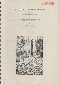
Book, Medlow Garden Survey and Landscape capability study 1983, Oct-83
... land surveys...Includes landscape story, cultural significance, particulars about vegetarian, garden, rehabilitation and plans. land surveys medlow garden bismark estate rosalie estate warrigal road surrey hills bismarck avenue warwick avenue t p payne (mr) hugh glass boroondara (mr) (maj) - cairncross (mrs) mary jane cairncross (dr) (mr) richard joseph bull (mrs) catherine grace bull (miss) norma bull (mr) ronald richard bull medlow Copy of a report giving a detailed landscape survey of Medlow Garden estate. ...Includes: Plan of Subdivision, Detailed plan, map of garden, Auctioneer's plan for 1854 sale, Botanical plan of Medlow & Landscape history notes. Full title : Medlow Garden survey and landscape capability survey. A report for the National Trust of Australia (Victoria) A report giving a detailed landscape survey of Medlow Garden estate. Includes landscape story, cultural significance, particulars about vegetarian, garden, rehabilitation and plans.Copy of a report giving a detailed landscape survey of Medlow Garden estate. Includes landscape story, cultural significance, particulars about vegetarian, garden, rehabilitation and plans. 38 pages with illustrations.land surveys, medlow garden, bismark estate, rosalie estate, warrigal road, surrey hills, bismarck avenue, warwick avenue, t p payne, (mr) hugh glass, boroondara, (mr) (maj) - cairncross, (mrs) mary jane cairncross, (dr) (mr) richard joseph bull, (mrs) catherine grace bull, (miss) norma bull, (mr) ronald richard bull, medlow -
 Surrey Hills Historical Society Collection
Book, Medlow Garden Survey and Landscape capability study 1983, Oct-83
... land surveys...Includes landscape history, cultural significance, particulars about vegetarian, garden, rehabilitation and plans. land surveys medlow garden bismark estate rosalie estate warrigal road surrey hills bismarck avenue warwick avenue T P payne (Mr) Hugh glass boroondara (maj.) ...Includes: Plan of Subdivision, Detailed plan, map of garden, Auctioneer's plan for 1854 sale, Botanical plan of Medlow & Landscape history notes. Full title : Medlow Garden survey and landscape capability survey. A report for the National Trust of Australia (Victoria) A report detailing the landscape survey of Medlow Garden estate. Includes landscape history, cultural significance, particulars about vegetarian, garden, rehabilitation and plans.A report detailing the landscape survey of Medlow Garden estate. Includes landscape history, cultural significance, particulars about vegetarian, garden, rehabilitation and plans. 38 p illland surveys, medlow garden, bismark estate, rosalie estate, warrigal road, surrey hills, bismarck avenue, warwick avenue, t p payne, (mr) hugh glass, boroondara, (maj.) (mr) - cairncross, (mrs) mary jane cairncross, (dr)(mr) richard joseph bull, (mrs) catherine grace bull, (miss) norma bull, (mr) ronald richard bull, medlow, house names, (mr) rex swanson, landform australia -
Whitehorse Historical Society Inc.
Document, Department of Crown Lands and Survey, 1983
... ...Land Surveys...Whitehorse Historical Society Inc. 2-10 Deep Creek Road Mitcham melbourne Crown Land Land Surveys Victorian Government Research guide of historical resources of the Department of Crown Lands and Survey. ...Research guide of historical resources of the Department of Crown Lands and Survey. Compiled by P. Cabena, Aug 1983Research guide of historical resources of the Department of Crown Lands and Survey. Compiled by P. Cabena, Aug 1983Research guide of historical resources of the Department of Crown Lands and Survey. Compiled by P. Cabena, Aug 1983crown land, land surveys, victorian government -
Whitehorse Historical Society Inc.
Document, Division of Survey and Mapping, 1984
... ...Land Surveys...Whitehorse Historical Society Inc. 2-10 Deep Creek Road Mitcham melbourne Crown Lands Victorian Government Land Surveys Information guide to Parish and Township Plans - Division of Survey and Mapping - Victorian Government.. ...Information guide to Parish and Township Plans - Division of Survey and Mapping - Victorian Government..Information guide to Parish and Township Plans - Division of Survey and Mapping - Victorian Government..Information guide to Parish and Township Plans - Division of Survey and Mapping - Victorian Government..crown lands, victorian government, land surveys -
Whitehorse Historical Society Inc.
Document, Division of Survey and Mapping, 1984
... ...Land Surveys...Whitehorse Historical Society Inc. 2-10 Deep Creek Road Mitcham melbourne Crown Lands Victorian Government Land Surveys A brief guide to Crown Lands And Survey records commonly used for family history research. ...A brief guide to Crown Lands And Survey records commonly used for family history research.A brief guide to Crown Lands And Survey records commonly used for family history research.A brief guide to Crown Lands And Survey records commonly used for family history research.crown lands, victorian government, land surveys -
 Whitehorse Historical Society Inc.
Document - Correspondence, Anderson's Creek, 19/12/1874
... ...Land Surveys...Bennett Hodgkinson Clement Andersons Creek Land Surveys Roads and Streets Letter of resignation, 19 December 1854, from W. ...Letter of resignation, 19 December 1854, from W. Bennett Hull to the Surveyor General regarding complaints about the supervision of Mr Hodgkinson, District Surveyor during survey of road to Anderson's Creek.hull, w. bennett, hodgkinson, clement, andersons creek, land surveys, roads and streets -
Canterbury History Group
Document - School Project: Elgar's Special Survey, Tudehope, Jennifer, 1963
... ... Land Surveys...Canterbury History Group 190A Canterbury Road Canterbury melbourne Canterbury Elgar> Henry T. Land Surveys Boroondara Campbell> J & R Dacre> R Towns> R. ...Well researched essay on the background of Elgar's Special Survey. Includes mapcanterbury, elgar> henry t., land surveys, boroondara, campbell> j & r, dacre> r, towns> r., sea> h., dyce> a., mccarthy> w.g., shenley> james, henty's paddock, norris> j.r., maling> j, canterbury road, survey road, boroondara roads board, camberwell historical society, mont albert road, brooks> r., land subdivisions -
 Bendigo Historical Society Inc.
Document - LANDS OFFICE : TANDARRA ESTATE, COUNTY OF BENDIGO, 1906 - 1920
... Land and Survey Officer...History House 11 Mackenzie Street Bendigo goldfields Land leases tandarra Bendigo Sandhurst lands Office land settlement Land and Survey Officer Document: green bound hard cover journal with red spine binding and corners. ...Document: green bound hard cover journal with red spine binding and corners. On spine ' Tandarra' written in black. Journal contains details of allotments leased in the Tandarra Estate. Maps and letters relating to blocks are enclosed. LH page: details of lessee, improvements (year range 1906 - 1920) , RH page: residence, population, results of cultivation, stock etc., remarks re lessee's gains or losses each year.Land and Survey Officerland leases, tandarra, bendigo, sandhurst, lands office, land settlement -
Whitehorse Historical Society Inc.
Document, History of the South Vermont area
... A short history of South vermont, from the land survey in 1855, including pioneers' names and occupations....A short history of South vermont, from the land survey in 1855, including pioneers' names and occupations. ...A short history of South vermont, from the land survey in 1855, including pioneers' names and occupations.A short history of South vermont, from the land survey in 1855, including pioneers' names and occupations.A short history of South vermont, from the land survey in 1855, including pioneers' names and occupations.vermont south, smith, l. l. dr., lobb, a, hoadley, mrs, confectionery, orchardists, norwich village, vermont, land subdivision -
 Ringwood and District Historical Society
Map - Survey Plans, Township of East Ringwood, Victoria - circa 1870s - 1950s
... Photocopies of two 1878 Land Survey maps with names of early selectors and names and dates detailing subsequent land purchases to circa 1950s. ...Photocopies of two 1878 Land Survey maps with names of early selectors and names and dates detailing subsequent land purchases to circa 1950s. ...Photocopies of two 1878 Land Survey maps with names of early selectors and names and dates detailing subsequent land purchases to circa 1950s. Third map (digitised copy only) "The East Estate by 1927" (from A South Australian Colonist of 1836 and His Descendants by Sir Ronald East - page 147). Includes Bedford Road and Illoura Avenue, Ringwood East. -
Federation University Art Collection
Work on paper - Digital Prints, Gilson, Deanne, 'Wadawurrung Axe Heads 1-4' by Deanne Gilson, 2011
... This work depicts an axehead found on Wadawurrung country and is a responce to workign alongside archeologists untertaking land surveys of her ancestral lands and the visual documentaiton of artefcts....The Art Collection features over 2000 works and was listed as a 'Ballarat Treasure' in 2007. art artwork deanne gilson gilson Wadawurrung stone axe aboriginal alumni This work depicts an axehead found on Wadawurrung country and is a responce to workign alongside archeologists untertaking land surveys of her ancestral lands and the visual documentaiton of artefcts. ...Dr Deanne GILSON (1967- ) Country: Wadawurrung Deanne Gilson is a Federation University alumni, and an award-winning multi-disciplinary artist. Her practice draws its inspiration from ‘Ancestral marks’ and design on cultural objects found in museum archives and family oral histories. Deanne’s practice seeks to interrogate the colonial legacy of settlement and the western hegemonic systems of class, race and representation in historical photographs that were imposed on her Ancestors. Her work also explores the matriarchal role through her feminist perspectives, looking at the history of marriage and the oppressive function it has played within her family. Deanne has completed the following educationala achievements. 2014 – 2015 Masters by Research (Visual Art), Deakin University Geelong 2013 Graduate Diploma in Education Secondary, Federation University 2011 Certificate IV in Aboriginal Contemporary Art & Craft 2010 Cultural Heritage Management Course, Lakes Entrance 1 Week 2007 – 2010 Graduated, Bachelor of Visual Arts with Honours, University of Ballarat 1984 Diploma of Art, School of Mines & Industries TAFE This item is part of the Federation University Art Collection. The Art Collection features over 2000 works and was listed as a 'Ballarat Treasure' in 2007.This work depicts an axehead found on Wadawurrung country and is a responce to workign alongside archeologists untertaking land surveys of her ancestral lands and the visual documentaiton of artefcts.art, artwork, deanne gilson, gilson, wadawurrung, stone axe, aboriginal, alumni -
 Federation University Historical Collection
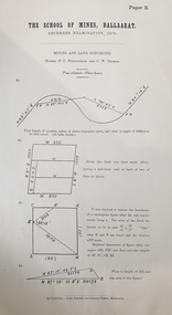
Document, The School of Mines Examinations, 1874-1882, 06/1874
... A number of printed, foolscap examinations for the Ballarat School of Mines, including: Mining and Land Surveying - Levelling (Examiners P.C. Fitzpatrick and C.W. ...Barker Library (top floor) Mount Helen goldfields ballarat school of mines examination engineers engineering p. matthews jonathan robinson A number of printed, foolscap examinations for the Ballarat School of Mines, including: Mining and Land Surveying - Levelling (Examiners P.C. Fitzpatrick and C.W. ...A number of printed, foolscap examinations for the Ballarat School of Mines, including: Mining and Land Surveying - Levelling (Examiners P.C. Fitzpatrick and C.W. Thomas, 1879 Metallurgy (Examiner J. Cosmo Newbery), 1882ballarat school of mines, examination, engineers, engineering, p. matthews, jonathan robinson -
Lakes Entrance Historical Society
Book, Morrissey D W and Morrissey E W, Lakes Entrance a Short History and Tourist Guide
... A short history of lakes Entrance from early settlement, including references to forest survey, land sales, shipping, fishing industry and development of the town and tourist industry ...A short history of lakes Entrance from early settlement, including references to forest survey, land sales, shipping, fishing industry and development of the town and tourist industry...Lakes Entrance Historical Society 4 Marine Parade Lakes Entrance gippsland A short history of lakes Entrance from early settlement, including references to forest survey, land sales, shipping, fishing industry and development of the town and tourist industry Settlers Land Settlement A short history of lakes Entrance from early settlement, including references to forest survey, land sales, shipping, fishing industry and development of the town and tourist industry Lakes Entrance a Short History and Tourist Guide Book Morrissey D W and Morrissey E W ...A short history of lakes Entrance from early settlement, including references to forest survey, land sales, shipping, fishing industry and development of the town and tourist industry A short history of lakes Entrance from early settlement, including references to forest survey, land sales, shipping, fishing industry and development of the town and tourist industrysettlers, land settlement -
 Federation University Historical Collection
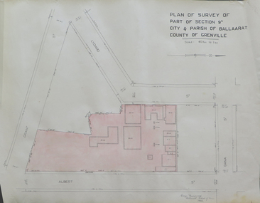
Plan, Plan of Survey of Part of Section 9A City & Parish of Ballarat County of Grenville (Albert Street frontage), 1932
... .1) Plan of SMB showing Albert, Grant, Lydiard and Dana streets, on paper with colored highlights undertaken by Ballarat School of Mines student George Murrowood in 1932 .2) Hand written page by George Murrowood, of technical description of land surveying Grade II 1932...John Trade Building was built on the Albert Street Frontage. ballarat school of mines surveying george murrowood albert street alumni m.b. john building architectural plan .1) Plan of SMB showing Albert, Grant, Lydiard and Dana streets, on paper with colored highlights undertaken by Ballarat School of Mines student George Murrowood in 1932 .2) Hand written page by George Murrowood, of technical description of land surveying Grade II 1932 Plan of Survey of Part of Section 9A City & Parish of Ballarat County of Grenville (Albert Street frontage) Plan Plan George Murrowood ...The M.B. John Trade Building was built on the Albert Street Frontage..1) Plan of SMB showing Albert, Grant, Lydiard and Dana streets, on paper with colored highlights undertaken by Ballarat School of Mines student George Murrowood in 1932 .2) Hand written page by George Murrowood, of technical description of land surveying Grade II 1932ballarat school of mines, surveying, george murrowood, albert street, alumni, m.b. john building, architectural plan -
 Bendigo Historical Society Inc.
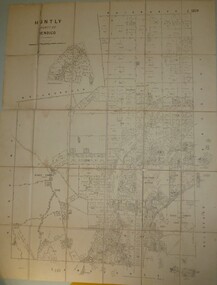
Map - JACK FLYNN COLLECTION: HUNTLY, 8/09/1921
... Photo Lithographed at the Department of Land and Survey Melbourne By W. J. Butson...Photo Lithographed at the Department of Land and Survey Melbourne By W. J. Butson Map: Parish of Huntly, County of Bendigo. ...Map: Parish of Huntly, County of Bendigo. Parish plan.By Authority, Govt., Printer. A. J. Mullett. Photo Lithographed at the Department of Land and Survey Melbourne By W. J. Butsonmap, bendigo, parish plan, huntly -
 Federation University Historical Collection
Booklet - Booklet - Prospectus, Bairnsdale District School of Mines, Prospectus, 1904, 1904
... It also includes a scale of fees, information on the Metallurgical Plant, Chemistry, Assaying and Metallurgy, Geology, Mining Geology, Mining, Petrology, Dynamics and Heat, Magnetism & Electricity, Mechanics Applied to Mining, Land Surveying, Mine Surveying, Algebra, Euclid, Trigonometry, Mechanical Drawing, Practical Plane Geometry, Practical Solid Geometry, Engineering Drawing, Art Subjects, and a list of certificates issued by the school since 1892....It also includes a scale of fees, information on the Metallurgical Plant and its chares, Chemistry, Assaying and Metallurgy, Geology, Mining Geology, Mining, Petrology, Dynamics and Heat, Magnetism & Electricity, Mechanics Applied to Mining, Land Surveying, Mine Surveying, Algebra, Euclid, Trigonometry, Mechanical Drawing, Practical Plane Geometry, Practical Solid Geometry, Engineering Drawing, Art Subjects, and a list of certificates issued by the school since 1892....It also includes a scale of fees, information on the Metallurgical Plant and its chares, Chemistry, Assaying and Metallurgy, Geology, Mining Geology, Mining, Petrology, Dynamics and Heat, Magnetism & Electricity, Mechanics Applied to Mining, Land Surveying, Mine Surveying, Algebra, Euclid, Trigonometry, Mechanical Drawing, Practical Plane Geometry, Practical Solid Geometry, Engineering Drawing, Art Subjects, and a list of certificates issued by the school since 1892. ...Higher education in east Gippsland dates back to 1890, and the opening of the Bairnsdale District School of Mines, In 1986 the Bairnsdale School of Mines and the Sale and Bairnsdale Technical schools amalgamated to form the East Gippsland Community College of TAFE. In 1995 it became the East Gippsland Institute of Technology, and in 2011 changed its name to Advance TAFE. The Bairnsdale District School of Mines Prospectus includes the members of council, a photographic image of the school, teaching staff, rules relating to students and instructors, Constitution, and a prospectus of subjects including Mining and Science Subjects, Diploma Courses, Preliminary Training, Metallurgy Course, Mining Engineering Course, Battery Manager's Certificate, Assayer's Certificate. It also includes a scale of fees, information on the Metallurgical Plant, Chemistry, Assaying and Metallurgy, Geology, Mining Geology, Mining, Petrology, Dynamics and Heat, Magnetism & Electricity, Mechanics Applied to Mining, Land Surveying, Mine Surveying, Algebra, Euclid, Trigonometry, Mechanical Drawing, Practical Plane Geometry, Practical Solid Geometry, Engineering Drawing, Art Subjects, and a list of certificates issued by the school since 1892.Grey soft covered book of 68 pages. The Bairsndale District School of Mines Prospectus includes the members of council, an photographic image of the school, teaching staff, rules relating to students and instructors, Constitution, and a prospectus of subjects including Mining and Science Subjects, Diploma Courses, Preliminary Training, Metallurgy Course, Mining Engineering Course, Battery Manager's Certificate, Assayer's Certificate. It also includes a scale of fees, information on the Metallurgical Plant and its chares, Chemistry, Assaying and Metallurgy, Geology, Mining Geology, Mining, Petrology, Dynamics and Heat, Magnetism & Electricity, Mechanics Applied to Mining, Land Surveying, Mine Surveying, Algebra, Euclid, Trigonometry, Mechanical Drawing, Practical Plane Geometry, Practical Solid Geometry, Engineering Drawing, Art Subjects, and a list of certificates issued by the school since 1892.bairnsdale district school of mines, bairnsdale, school of mines, donald clark, francis w. sewell, j.v.r. anderson, a.d. pleydell, walter seehusen, director, mining engineering, metallurgy, academy of arts, municipal surveyor, 1914 -
 Bendigo Historical Society Inc.
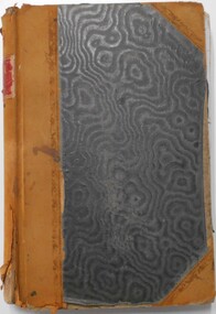
Document - LANDS OFFICE, CROWN LANDS SURVEYED AND SOLD, 1860/70
... Contains list of parishes in front cover, indexed to page numbers which describes land surveyed and sold in parishes. Double page entries. 230 pages in book. ...History House 11 Mackenzie Street Bendigo goldfields Land sales Lands office land surveyed land sold Bendigo Sandhurst Lands Office Document: buff hard cover journal, embossed on borders. ...Document: buff hard cover journal, embossed on borders. On spine 'Lands and Survey' 'Index Book' and '03'. Contains list of parishes in front cover, indexed to page numbers which describes land surveyed and sold in parishes. Double page entries. 230 pages in book. LH page ' town lands, suburban lands, country lands, total lands surveyed, date of survey. RH page: date of sale, by auction, by selection, price per acre, total amount name of purchaser.Lands Officeland sales, lands office, land surveyed, land sold, bendigo, sandhurst -
 Bendigo Historical Society Inc.
Document - LANDS OFFICE - CROWN LANDS SURVEYED AND SOLD SANDHURST, 1860 onwards
... Contains details of crown land surveyed and sold in the district of Sandhurst. ...Contains details of crown land surveyed and sold in the district of Sandhurst. ...Journal: LANDS OFFICE - CROWN LANDS SURVEYED AND SOLD SANDHURST green hard cover journal with buff spine and corners. Contains details of crown land surveyed and sold in the district of Sandhurst. Indexed in front by parish, alphabetical double pages not numbered. On LH page, parish, town, suburban, country, date of survey. On RH page, date of sale, auction, selection, price, total amount, purchaser. On spine ' index book' 'F' and '09'. Dated from 1860 onwardsLands Officeland sales, bendigo -
 Victorian Aboriginal Corporation for Languages
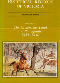
Book, Michael Cannon, Historical records of Victoria : foundation series : volume 6 : the crown, the land and the squatter 1835-1840, 1991
... A history of land grants, surveying, squatters? life and land use during this period....A history of land grants, surveying, squatters? life and land use during this period. ...Reproductions of various transactions and reports dealing with squatting, land tenure and agricultural production in Port Phillip in the years 1835-1840. A history of land grants, surveying, squatters? life and land use during this period.maps, b&w illustrations, colour illustrationsvictorian history -
 Federation University Historical Collection
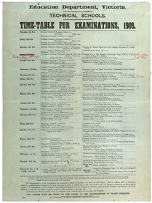
poster, J. Kemp, Education Department Victoria Technical School Timetable for Examinations, 1910, 1910
... Subjects included Chemistry, Geology, Asssaying, Hydraulics, Agriculture, Engineering , Mine Surveying, Algebra, Mineralogy, petrology, Botany, Trigonometry, Euclid, Land Surveying, Steam and gas Engines, Applied Mechanics, Drawing, painting, engineering drawing, building construction, architecture, drapery, modelled design, casting clay models, composition of form and colour, Lettering, Wood Carving, historic ornament, Wood Carving. .1) Trade Subjects .2) Other subjects, including art...Subjects included Chemistry, Geology, Asssaying, Hydraulics, Agriculture, Engineering , Mine Surveying, Algebra, Mineralogy, petrology, Botany, Trigonometry, Euclid, Land Surveying, Steam and gas Engines, Applied Mechanics, Drawing, painting, engineering drawing, building construction, architecture, drapery, modelled design, casting clay models, composition of form and colour, Lettering, Wood Carving, historic ornament, Wood Carving. .1) Trade Subjects .2) Other subjects, including art Education Department Victoria Technical School Timetable for Examinations, 1910 poster J. ...Large printed timetable for Technical School examinations in 1901. Subjects included Chemistry, Geology, Asssaying, Hydraulics, Agriculture, Engineering , Mine Surveying, Algebra, Mineralogy, petrology, Botany, Trigonometry, Euclid, Land Surveying, Steam and gas Engines, Applied Mechanics, Drawing, painting, engineering drawing, building construction, architecture, drapery, modelled design, casting clay models, composition of form and colour, Lettering, Wood Carving, historic ornament, Wood Carving. .1) Trade Subjects .2) Other subjects, including artexaminations, technical schools, trades, art, technical art school, timetable, clay modelling, ceramics