Showing 288 items matching "lot 3"
-
 Ringwood and District Historical Society
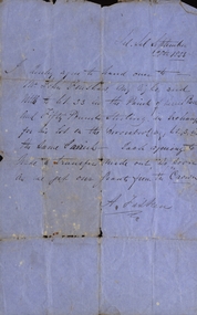
Legal record - Conditions of Sale (C.E.Carter), Ringwood - Lot 3, Plan of Subdivision No 11956, Mrs S Corrie to Holeproof Ltd, 1944
... Ringwood - Lot 3, Plan of Subdivision No 11956, Mrs S Corrie to Holeproof Ltd, 1944...Register No 11956. Ringwood - Lot 3, Plan of Subdivision No 11956, Mrs S Corrie to Holeproof Ltd, 1944 Legal record Conditions of Sale (C.E.Carter) ...Particulars and Conditions of Sale of Property , from Mrs S Corrie to Holeproof Ltd. Register No 11956. -
Ringwood and District Historical Society
Legal record - Conditions of Sale (C.E.Carter), Ringwood , Lot 3 on Plan of Subdivision No 3916441, Mr W. Ballock to Mr & Mrs Bott circa 1943
... Ringwood , Lot 3 on Plan of Subdivision No 3916441, Mr W. ...Ringwood and District Historical Society 125A Warrandyte Road Ringwood North melbourne Particulars and Conditions of Sale of Property , from Mr W.Ballock to Mr & Mrs Bott. Ringwood , Lot 3 on Plan of Subdivision No 3916441, Mr W. ...Particulars and Conditions of Sale of Property , from Mr W.Ballock to Mr & Mrs Bott. -
Ringwood and District Historical Society
Legal record - Conditions of Sale (C.E.Carter), Ringwood , Lot 3 on Plan of Subdivision 10519, Mrs S.H.Houston to Mr J.J.Constable, Circa 1940
... Ringwood , Lot 3 on Plan of Subdivision 10519, Mrs S.H.Houston to Mr J.J.Constable, Circa 1940....Ringwood and District Historical Society 125A Warrandyte Road Ringwood North melbourne Particulars and Conditions of Sale of Property , from Mrs S.H.Houston to Mr J.J.Constable. Ringwood , Lot 3 on Plan of Subdivision 10519, Mrs S.H.Houston to Mr J.J.Constable, Circa 1940. ...Particulars and Conditions of Sale of Property , from Mrs S.H.Houston to Mr J.J.Constable. -
Whitehorse Historical Society Inc.
Document, War Service Homes Commission, 1948
... for E.J. Harle at Lot 3, Springvale Road, Nunawading, approved by Council 10 Nov 1948....Specification and plans for War Service Homes Commission for E.J. Harle at Lot 3, Springvale Road, Nunawading, approved by Council 10 Nov 1948....Whitehorse Historical Society Inc. 2-10 Deep Creek Road Mitcham melbourne for E.J. Harle at Lot 3, Springvale Road, Nunawading, approved by Council 10 Nov 1948. ...Specification and plans for War Service Homes CommissionSpecification and plans for War Service Homes Commission for E.J. Harle at Lot 3, Springvale Road, Nunawading, approved by Council 10 Nov 1948.Specification and plans for War Service Homes Commission plans, war service homes commission, harle, e.j., springvale road, nunawading -
 Whitehorse Historical Society Inc.
Document, Land Sales
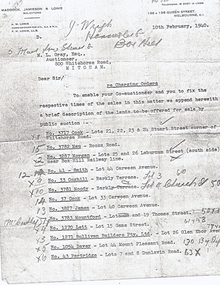
... ...lot 3...Whitehorse Historical Society Inc. 2-10 Deep Creek Road Mitcham melbourne cock stuart street blackburn whitehorse road mau rooks road mitcham morgan laburnum street lots 25 26 smith carween avenue lot 44 coghill barkly terrace lot 3 moody church street lot 4 cook lot 33 james lot 40 mountford thomas street lot 19 lett game street lot 15 sullivan builders pty ltd glen ebor avenue lot 26 davey mount pleasant road forest hill partridge dunlavin road lots 7 & 8 wright mcdowall street lots 106 - 7 gibb lot 9 Letter from A. ...Letter from A. M. Lonie of Maddock, Jameson & Lonie, solicitors to M.L. Grey Esq , Auctioneer,Letter from A. M. Lonie of Maddock, Jameson & Lonie, solicitors to M.L. Grey Esq , Auctioneer, 800 Whitehorse Rd, Mitcham regarding charging orders for land sales.Letter from A. M. Lonie of Maddock, Jameson & Lonie, solicitors to M.L. Grey Esq , Auctioneer,cock, stuart street, blackburn, whitehorse road, mau, rooks road, mitcham, morgan, laburnum street, lots 25, 26, smith, carween avenue, lot 44, coghill, barkly terrace, lot 3, moody, church street, lot 4, cook, lot 33, james, lot 40, mountford, thomas street, lot 19, lett, game street, lot 15, sullivan builders pty ltd, glen ebor avenue, lot 26, davey, mount pleasant road, forest hill, partridge, dunlavin road, lots 7 & 8, wright, mcdowall street, lots 106 - 7, gibb, lot 9 -
 Ringwood and District Historical Society
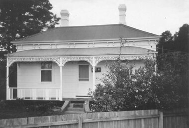
Photograph, Lot 66 (No.5) Howard Ave, Ringwood East, taken from backyard of Lot 67 (No.3) - 1/9/1974
... Lot 66 (No.5) Howard Ave, Ringwood East, taken from backyard of Lot 67 (No.3) - 1/9/1974....Black and white photograph Lot 66 (No.5) Howard Ave, Ringwood East, taken from backyard of Lot 67 (No.3) - 1/9/1974. Photograph ...Black and white photographRefer also to VC5127 for original Land Sale Brochure of 'Dublin Road Station Estate', 1923. -
 Ringwood and District Historical Society
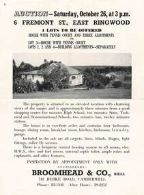
Flyer, Auction Saturday 26th October at 6 Fremont Street, Ringwood East - circa 1960
... 2-sided A4 size page with auction details. 4 lots to be offered House with tennis court and three allotments, or Lot 3 - House with tennis court Lots 1,2 and 4 - Building allotments separately....Map includes outline of 4 allotments on Fremont Road (later Fremont Street), south of Bedford Road, Ringwood. Terms - Lot 3: £1,250 deposit, £8 p.w. inc. Int. 6½% quart. rests. ...Map includes outline of 4 allotments on Fremont Road (later Fremont Street), south of Bedford Road, Ringwood. Terms - Lot 3: £1,250 deposit, £8 p.w. inc. Int. 6½% quart. rests. ...2-sided A4 size page with auction details. 4 lots to be offered House with tennis court and three allotments, or Lot 3 - House with tennis court Lots 1,2 and 4 - Building allotments separately.Map includes outline of 4 allotments on Fremont Road (later Fremont Street), south of Bedford Road, Ringwood. Terms - Lot 3: £1,250 deposit, £8 p.w. inc. Int. 6½% quart. rests. Bal. 7 yrs. Lots 1, 2 and 4: £100 deposit, £2/10/- p.w. inc. Int. 6½% quart. rests. Bal. 5 yrs. Auctioneers: Broomhead & Co., R.E.S.I. 741 Burke Road, Camberwell, Phone: 8211342 After Hours: 29-2252. -
Whitehorse Historical Society Inc.
Document, Title to 59 Mount Pleasant Road Nunawading, 1871 - 1992
... Copies of Title documents for Lot 3, Plan of Subdivision 18705 for Section 117b, Parish of Nunawading from 1871 to 1992....Copies of Title documents for Lot 3, Plan of Subdivision 18705 for Section 117b, Parish of Nunawading from 1871 to 1992. ...Copies of Title documents for Lot 3, Plan of Subdivision 18705 for Section 117b, Parish of Nunawading from 1871 to 1992.Copies of Title documents for Lot 3, Plan of Subdivision 18705 for Section 117b, Parish of Nunawading from 1871 to 1992.Copies of Title documents for Lot 3, Plan of Subdivision 18705 for Section 117b, Parish of Nunawading from 1871 to 1992.mount pleasant road, nunawading no. 59, land titles, jones, dan, jones, anne -
Whitehorse Historical Society Inc.
Article, Blackburn
... Advertisement for Lots 2&3, The Avenue, Blackburn....Whitehorse Historical Society Inc. 2-10 Deep Creek Road Mitcham melbourne the avenue blackburn morton thomas richards burrowes & son Advertisement for Lots 2&3, The Avenue, Blackburn. Advertisement for Lots 2&3, The Avenue, Blackburn. ...Advertisement for Lots 2&3, The Avenue, Blackburn.Advertisement for Lots 2&3, The Avenue, Blackburn.Advertisement for Lots 2&3, The Avenue, Blackburn.the avenue, blackburn, morton, thomas richards burrowes & son -
Whitehorse Historical Society Inc.
Document, Certificate of Title, 1925, 1933
... Certificate of Title, Lot 3 Whitehorse Road, Blackburn. Vol 5003 Fol 1000596. ...Land Titles Shire of Blackburn and Mitcham Gould Mary Jane Whitehorse Road Mitcham Rates Certificate of Title, Lot 3 Whitehorse Road, Blackburn. Certificate of Title, Lot 3 Whitehorse Road, Blackburn. ...Certificate of Title, Lot 3 Whitehorse Road, Blackburn.Certificate of Title, Lot 3 Whitehorse Road, Blackburn. Vol 5003 Fol 1000596. Mary Jane Gould. Rates enforcement of charge, 1933. Municipal correspondence about house and rates arrears.Certificate of Title, Lot 3 Whitehorse Road, Blackburn. land titles, shire of blackburn and mitcham, gould, mary jane, whitehorse road, mitcham, rates -
 Bacchus Marsh & District Historical Society
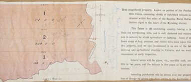
Map, Pentland Hills Estate Land Sale 1904
... Lot l, 212 acres was sold to Messrs Thomas and Robert Lidgett of Myrniong, at £11/15/ per acre, lot 2, 200 acres, to Mr David Robertson, of Bacchus Marsh, at £9 17/0 per acre, and lot 3, 38 acres, was sold to Mr James Norton, jun at £11 per acre. ...A single page paper map showing a portions of land available for sale from the Pentland Hills Estate near Bacchus Marsh.The name of the seller, Mrs Grant, can seen handwritten on this map and the buyers of the three portions for sale, Lidgett lot 1, Robertson lot 2 and Morton lot 3. Parts of the text are missing along the edges due to tearing or excessive trimming of the edges. ...Lot l, 212 acres was sold to Messrs Thomas and Robert Lidgett of Myrniong, at £11/15/ per acre, lot 2, 200 acres, to Mr David Robertson, of Bacchus Marsh, at £9 17/0 per acre, and lot 3, 38 acres, was sold to Mr James Norton, jun at £11 per acre. ...The Pentland Hills Estate property shown in this auction plan was put up for sale in 1904. It was a deceased estate sale. The property had been owned by Peter Grant who died in 1899. Peter Grant had worked and farmed in the Myrniong area for many years and had also been a Councillor on the Bacchus Marsh Shire for a number of terms. A property sales report in the Express newspaper recorded that the land for sale comprised 500 acres of the old Pentland Hills Estate. It was subdivided into three lots, all of which were sold at good prices. Lot l, 212 acres was sold to Messrs Thomas and Robert Lidgett of Myrniong, at £11/15/ per acre, lot 2, 200 acres, to Mr David Robertson, of Bacchus Marsh, at £9 17/0 per acre, and lot 3, 38 acres, was sold to Mr James Norton, jun at £11 per acre. A single page paper map showing a portions of land available for sale from the Pentland Hills Estate near Bacchus Marsh.The name of the seller, Mrs Grant, can seen handwritten on this map and the buyers of the three portions for sale, Lidgett lot 1, Robertson lot 2 and Morton lot 3. Parts of the text are missing along the edges due to tearing or excessive trimming of the edges. The map is pasted into a bound volume containing 76 maps or plans in total. High resolution digital image stored on BMDHS computer network. Handwritten: Mrs Grant, Myrniong, Executrix in the deceased Estate of Mr. Peter Grant to sell by public auction.land sales, pentland hills maps, myrniong area land sales, pentland hills estate -
 Ringwood and District Historical Society
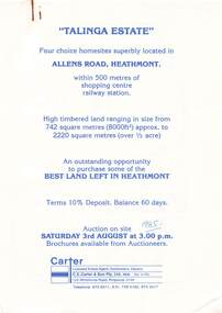
Flyer, Land Auction Advertisement, Talinga Estate, Allens Road, Heathmont, Vic. - 1985
... Handwritten sale price annotations - Lot 1 Sold $42,000, Lot 2 Sold $42,200, Lot 3 Sold $41,500, Lot 4 Sold $53,000....Ringwood and District Historical Society 125A Warrandyte Road Ringwood North melbourne Handwritten sale price annotations - Lot 1 Sold $42,000, Lot 2 Sold $42,200, Lot 3 Sold $41,500, Lot 4 Sold $53,000. Double sided A4 page with subdivision map showing location and size of allotments for auction on Saturday 3rd August (1985). ...Double sided A4 page with subdivision map showing location and size of allotments for auction on Saturday 3rd August (1985). Agent - C.E. Carter & Son Pty. Ltd., 122 Whitehorse Road, Ringwood 3134, Telephone 870 6211.Handwritten sale price annotations - Lot 1 Sold $42,000, Lot 2 Sold $42,200, Lot 3 Sold $41,500, Lot 4 Sold $53,000. -
 Ringwood and District Historical Society
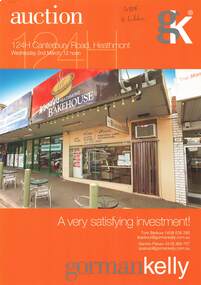
Document, Retail Property Auction Notice and Information Memorandum, 124H Canterbury Road, Heathmont - 2011
... Stapled A4 colour photocopy of advertisement for auction on Wednesday 2nd March 2011, with 19-page information memorandum including Title particulars - Lot 3 on Plan of Subdivision 332557, site details and town planning/zoning....Stapled A4 colour photocopy of advertisement for auction on Wednesday 2nd March 2011, with 19-page information memorandum including Title particulars - Lot 3 on Plan of Subdivision 332557, site details and town planning/zoning. ...Stapled A4 colour photocopy of advertisement for auction on Wednesday 2nd March 2011, with 19-page information memorandum including Title particulars - Lot 3 on Plan of Subdivision 332557, site details and town planning/zoning.Currently leased to "The Heathmont Bakehouse". Handwritten agents' sales notations on some pages. Agents - Gorman Kelly Licensed Estate Agents Auctioneers & Property Managers, 1 Oxley Road Hawthorn, Victoria 3122. Telephone 03 9810 7200 Facsimile 03 9810 7299. -
 Bendigo Military Museum
Equipment - AMMUNITION POUCHES, Unknown
... "5.56mm Ball M193". "10 RD CLIPS". "LOT LC 3-245"....Passchendaele Barracks Trust PBT254 5.56mm Ball Carry Bag Equipment "5.56mm Ball M193". "10 RD CLIPS". "LOT LC 3-245". 1. & 2. Vietnam era 5.56 mm Ball ammunition carry bag. ...1. & 2. Vietnam era 5.56 mm Ball ammunition carry bag. Seven (7) pockets with the capability of carrying rifle clips of 10 rounds. The carry bags have over the shoulder carry straps. This equipment was considered disposable after use."5.56mm Ball M193". "10 RD CLIPS". "LOT LC 3-245".passchendaele barracks trust, pbt254, 5.56mm ball carry bag, equipment -
 Kew Historical Society Inc
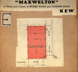
Plan - Subdivision Plan, Maxwelton, Kew, 1920-1940
... The subdivision, ‘Maxwelton’, included four lots in East Kew, at the northwest corner of Burke Road and Cotham Road. Lot 3 is identified as the location of an existing house. ...The subdivision, ‘Maxwelton’, included four lots in East Kew, at the northwest corner of Burke Road and Cotham Road. Lot 3 is identified as the location of an existing house. ...Pru Sanderson, in her groundbreaking ‘City of Kew Urban Conservation Study : Volume 2 - Development History’ (1988), summarised the periods of urban development and subdivisions of land in Kew. The periods that she identified included 1845-1880, 1880-1893, 1893-1921, 1921-1933, 1933-1943, and Post-War Development. These periods were selected as they represented periods of rapid growth or decline in urban development. An obvious starting point for Sanderson’s groupings involved population growth and the associated economic cycles. These cycles also highlighted urban expansion onto land that was predominantly rural, although in other cases it represented the decline and breakup of large estates. A number of the plans in the Kew Historical Society’s collection can also be found in other collections, such as those of the State Library of Victoria and the Boroondara Library Service. A number are however unique to the collection.The Kew Historical Society collection includes almost 100 subdivision plans pertaining to suburbs of the City of Melbourne. Most of these are of Kew, Kew East or Studley Park, although a smaller number are plans of Camberwell, Deepdene, Balwyn and Hawthorn. It is believed that the majority of the plans were gifted to the Society by persons connected with the real estate firm - J. R. Mathers and McMillan, 136 Cotham Road, Kew. The Plans in the collection are rarely in pristine form, being working plans on which the agent would write notes and record lots sold and the prices of these. The subdivision plans are historically significant examples of the growth of urban Melbourne from the beginning of the 20th Century up until the 1980s. A number of the plans are double-sided and often include a photograph on the reverse. A number of the latter are by noted photographers such as J.E. Barnes.The subdivision, ‘Maxwelton’, included four lots in East Kew, at the northwest corner of Burke Road and Cotham Road. Lot 3 is identified as the location of an existing house. The site of the subdivision equates to that parcel of land where a contemporary block of three storey apartments at 1245 Burke Road is now located.subdivision plans - kew, mazwelton subdivision, burke road -- kew (vic.), cotham road -- kew (vic.) -
 Bendigo Military Museum
Equipment - GAS MASK
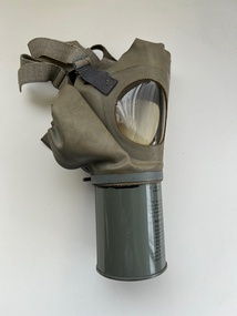
... Imprinted into vinyl: “Med Adult” Stamped in black on vinyl: “Lot 21-3-SG”...Bendigo Military Museum 37 - 39 Pall Mall Bendigo goldfields military equipment Passchendaele barracks trust Gas masks Imprinted into vinyl: “Med Adult” Stamped in black on vinyl: “Lot 21-3-SG” Vinyl gas mask with webbing straps & transparent eye pieces attached to a metal canister. ...Vinyl gas mask with webbing straps & transparent eye pieces attached to a metal canister. Instructions for use & maintenance are printed on the side of canister.Imprinted into vinyl: “Med Adult” Stamped in black on vinyl: “Lot 21-3-SG”military equipment, passchendaele barracks trust, gas, masks -
Whitehorse Historical Society Inc.
Pamphlet, Maroondah Highway, Nunawading, 1/10/1999 12:00:00 AM
... 3 lots for auction, 27 October 1999. Agent; Collier. ...Auction brochure for 360 Maroondah Highway, Nunawading [Whitehorse Road]. 3 lots for auction, 27 October 1999. Agent; Collier. ...Whitehorse Historical Society Inc. 2-10 Deep Creek Road Mitcham melbourne 3 lots for auction, 27 October 1999. Agent; Collier. ...Auction brochure for 360 Maroondah Highway, Nunawading [Whitehorse Road].Auction brochure for 360 Maroondah Highway, Nunawading [Whitehorse Road]. 3 lots for auction, 27 October 1999. Agent; Collier. Site of the former Nunawading Council Chambers. Includes aerial photo of Nunawading including Whitehorse Rd / Springvale Rd corner and Nunawading Railway Station area.Auction brochure for 360 Maroondah Highway, Nunawading [Whitehorse Road]. whitehorse road, nunawading, no 360, city of nunawading. council chambers, municipal chambers, springvale road, nunawading, nunawading railway station -
 National Vietnam Veterans Museum (NVVM)
Equipment - Equipment, Army, Weapons Trunk
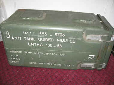
... Serial No: 73330 Lot No: 3 NA 65...Serial No: 73330 Lot No: 3 NA 65 Weapons Trunk Equipment Equipment, Army ...A green plastic container for storage of Anti tank Guided Missile Entac 130-59. Serial No: 73330 Lot No: 3 NA 65trunk, weapons, anti tank guided missile -
 Bendigo Historical Society Inc.
Document - H.A. & S.R. WILKINSON COLLECTION: CONTRACT OF SALE
... Svanosio (buyer) for land situate in Sternberg Street, Bendigo, being lot 3 on plan of sub-division No. 13862, having a frontage of 60 feet by a depth of 107 feet. ...Svanosio (buyer) for land situate in Sternberg Street, Bendigo, being lot 3 on plan of sub-division No. 13862, having a frontage of 60 feet by a depth of 107 feet. ...This business was owned by father and son, Henry Archibald Wilkinson and Samuel Ronald "Ron" Wilkinson. Henry (1882-1954) was born in Shepparton and died in Bendigo. He was married to Grace Hovendon in 1908. Samuel Ronald "Ron" (1914-1995), Henry's son, was married to Florence Jean McKerlie in 1937.Conditions of sale by private contract dated 26th November, 1937 between Mrs. R.E. Mahon (seller) and N.L. Svanosio (buyer) for land situate in Sternberg Street, Bendigo, being lot 3 on plan of sub-division No. 13862, having a frontage of 60 feet by a depth of 107 feet. Price 40 pounds. Attached a drawing of the sub-division.organization, business, h.a. & s.r wilkinson real estate -
 Bendigo Historical Society Inc.
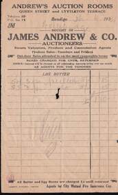
Document - W. BABIDGE COLLECTION: ANDREW'S AUCTION ROOMS DOCKET
... Buff coloured docket from Andrew's Auction Rooms two lots of 3 pr pullets 5/- for a total of £1/10/-. ...Lamson paragon Limited Buff coloured docket from Andrew's Auction Rooms two lots of 3 pr pullets 5/- for a total of £1/10/-. ...Buff coloured docket from Andrew's Auction Rooms two lots of 3 pr pullets 5/- for a total of £1/10/-. Docket dated 26-6-1931.document, w. babidge collection - andrew's auction rooms docket, james andrew & co., lamson paragon limited -
 Greensborough Historical Society
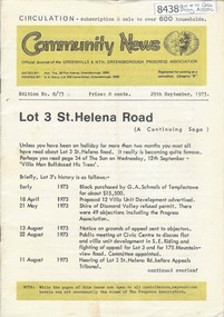
Newsletter, Greenhills and North Greensborough Progress Association, Community News: official journal of the Greenhills and Nth. Greensborough Progress Association. 29th September 1973. Edition No. 8/73, 29/09/1973
... This edition includes a report on the Progress Association's September 1973 meeting, Councillor's report, Lot 3 St. Helena Road, In Memoriam [Frank Andrew], School and Kinder news, St. ...Greensborough Historical Society 34A Glenauburn Road Lower Plenty Lower Plenty melbourne This edition includes a report on the Progress Association's September 1973 meeting, Councillor's report, Lot 3 St. Helena Road, In Memoriam [Frank Andrew], School and Kinder news, St. ...This edition includes a report on the Progress Association's September 1973 meeting, Councillor's report, Lot 3 St. Helena Road, In Memoriam [Frank Andrew], School and Kinder news, St. Helena Road... now and before, Forward planning and balanced development, Preservation of the local environment, Public reserves and how to protect them. A digital copy of this Newsletter is available from Greensborough Historical Society.Newsletter, 20 p., illus.greenhills and north greensborough progress association, greenhills -
 Moorabbin Air Museum
Equipment (Item) - Gas Mask U.S. Military Issue (Adult Medium)
... Mask inscribed with lot no.21-3-SC....Mask inscribed with lot no.21-3-SC. The mask consists of a rubberised body with two plastic lenses and the filter attached directly to the mouth area. ...Historic item used in WW2Instructions for use printed on cannister. Mask inscribed with lot no.21-3-SC. -
 Bendigo Historical Society Inc.
Document - H. A. & S. R. WILKINSON COLLECTION: CONTRACT OF SALE
... Property: land being lot 3 on plan of subdivision lodged in the office of titles, having a frontage of 50 feet by a depth of 150 feet, being part of Crown allotment 547section H and situate in Osborne Street, Bendigo, together with 5 roomed weatherboard dwelling and all sundry. ...Property: land being lot 3 on plan of subdivision lodged in the office of titles, having a frontage of 50 feet by a depth of 150 feet, being part of Crown allotment 547section H and situate in Osborne Street, Bendigo, together with 5 roomed weatherboard dwelling and all sundry. ...Contract of sale of land dated 17th August, 1955 between Mr. H. B. Morgan (vendor) and Mr. L. H. Parsons (purchaser). Property: land being lot 3 on plan of subdivision lodged in the office of titles, having a frontage of 50 feet by a depth of 150 feet, being part of Crown allotment 547section H and situate in Osborne Street, Bendigo, together with 5 roomed weatherboard dwelling and all sundry. Price: 3,300 pounds.organization, business, h.a. & s.r wilkinson real estate -
 Bendigo Historical Society Inc.
Document - H. A. & S. R. WILKINSON COLLECTION: CONTRACT OF SALE
... Speer (purchaser). Property: lots 3 and 4 on plan of subdivision made by Alwyn Ernest Pritchard Licensed Surveyor dated the 19th of October, 1950 and being part of Crown allotment 230, 231, 232, 233 and 125 section H, Parish of Sandhurst City of Bendigo. ...Speer (purchaser). Property: lots 3 and 4 on plan of subdivision made by Alwyn Ernest Pritchard Licensed Surveyor dated the 19th of October, 1950 and being part of Crown allotment 230, 231, 232, 233 and 125 section H, Parish of Sandhurst City of Bendigo. ...BHS CollectionContract of sale of land dated 29th November, 1950 between Miss H. Barrass (vendor) and Mrs. M. Speer (purchaser). Property: lots 3 and 4 on plan of subdivision made by Alwyn Ernest Pritchard Licensed Surveyor dated the 19th of October, 1950 and being part of Crown allotment 230, 231, 232, 233 and 125 section H, Parish of Sandhurst City of Bendigo. Price: 3,700 pounds. Attached 8 hand written notes.organization, business, h.a. & s.r wilkinson real estate -
 Bendigo Historical Society Inc.
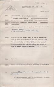
Document - H. A. & S. R. WILKINSON COLLECTION: CONTRACT OF SALE
... Property: Sterry Street, West Bendigo being lot 3 on plan of subdivision No. 52992 land described in certificate of title volume 8399 folio 464. ...Property: Sterry Street, West Bendigo being lot 3 on plan of subdivision No. 52992 land described in certificate of title volume 8399 folio 464. ...Contract of sale of real estate dated 8th November, 1963 between Mr. R. P. & Mrs. M. O. Miller (vendor) and Mr. E. C. Spence (purchaser). Solicitor for vendor: Watson, James & Rogers, Bull Street, Bendigo. Solicitor for purchaser: Watson, James & Rogers, Bull Street, Bendigo. Property: Sterry Street, West Bendigo being lot 3 on plan of subdivision No. 52992 land described in certificate of title volume 8399 folio 464. Price: 400 pounds.organization, business, h.a. & s.r wilkinson real estate -
 Bendigo Historical Society Inc.
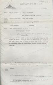
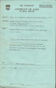
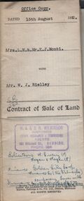
Document - H.A. & S.R. WILKINSON COLLECTION: CONDITION OF SALE
... Rielley for land being Lot 3 on plan of subdivision lodged in the office of titles in red ink No. 5062838 and being part of Crown allotment 20A section 16, City of Bendigo, Parish of Sandhurst, County of Bendigo and situate in Napoleon Crescent, White Hills, together with 6-roomed weatherboard dwelling and all sundry. ...Rielley for land being Lot 3 on plan of subdivision lodged in the office of titles in red ink No. 5062838 and being part of Crown allotment 20A section 16, City of Bendigo, Parish of Sandhurst, County of Bendigo and situate in Napoleon Crescent, White Hills, together with 6-roomed weatherboard dwelling and all sundry. ...BHS CollectionContract of sale of land issued by H.A. Wilkinson and dated 15th August, 1952 between Mrs. L.M. & Mr. K. J. Monti (sellers) and Mr. W.J. Rielley for land being Lot 3 on plan of subdivision lodged in the office of titles in red ink No. 5062838 and being part of Crown allotment 20A section 16, City of Bendigo, Parish of Sandhurst, County of Bendigo and situate in Napoleon Crescent, White Hills, together with 6-roomed weatherboard dwelling and all sundry. Price 2,850 pounds.organization, business, h.a. & s.r wilkinson real estate -
Kew Historical Society Inc
Plan - Tramway Estate, Camberwell North, 1937
... Within the plan, lots 3 to 342 are listed as lots. The plan includes annotations in ink indicating the prices realised by a number of lots. ...Within the plan, lots 3 to 342 are listed as lots. The plan includes annotations in ink indicating the prices realised by a number of lots. ...Subdivision plans and real estate flyers/brochures reveal a number of aspects of urban development and history. The Kew Historical Society's collection of these plans, as well as advertisements extracted from magazines, cover key aspects of community development and architectural history of Kew and Kew Eat as well as surrounding suburbs. While most of the plans in the collection were gifted to the Society by the former City of Kew, a number of other plans and advertisements have been donated by individuals, of which this is an example.Single page subdivision plan listing properties for sale in the Tramways Estate, Camberwell North. The large estate was bounded by Doncaster Road, Burke Road, Marwan Avenue, Maud Street, Severn Street, and extended over Glass's Creek at Mayland's Avenue. Within the plan, lots 3 to 342 are listed as lots. The plan includes annotations in ink indicating the prices realised by a number of lots. A key explains that lots with an 'H' represent a house, whereas the 37 shaded lots represent those being offered by this agent. subdivision plans -- camberwell (vic.), tramways estate -
 Federation University Historical Collection
Document, Archibald Fisken, Bill of Sale, 1855, 28/09/1855
... Lal Lal September 28th 1855 I hereby agre to hand over to Mr John Bonshaw my right and title to lot 33 in the parish of Kirit Berrit and Fifty Pounds Sterling in Exchange for his lot on the Moorabool [?], lot 3 in the same Parrish. Each agreeing to trade & transfer made out, as soon as we get our grants from the Crown. ...Archibald Fisken John Foushaw bill of sale land transfer squatter John Bonshaw Lal Lal September 28th 1855 I hereby agre to hand over to Mr John Bonshaw my right and title to lot 33 in the parish of Kirit Berrit and Fifty Pounds Sterling in Exchange for his lot on the Moorabool [?], lot 3 in the same Parrish. Each agreeing to trade & transfer made out, as soon as we get our grants from the Crown. ...Hand written bill of sale between A. Fisken and John [Bonshaw?]Lal Lal September 28th 1855 I hereby agre to hand over to Mr John Bonshaw my right and title to lot 33 in the parish of Kirit Berrit and Fifty Pounds Sterling in Exchange for his lot on the Moorabool [?], lot 3 in the same Parrish. Each agreeing to trade & transfer made out, as soon as we get our grants from the Crown. A. Fisken. archibald fisken, john foushaw, bill of sale, land transfer, squatter, john bonshaw -
 Moorabbin Air Museum
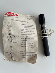
Accessory (item) - Signal Kit MBA-201G (LESS FLARES), With Information Card, Signal Kit MBA-201G(LESS FLARES), With Information Card
... 137-00-490-7362 CG/127418/J 12543 Lot MBA1-5-3...Moorabbin Air Museum Moorabbin Airport 12 First Street Moorabbin melbourne 137-00-490-7362 CG/127418/J 12543 Lot MBA1-5-3 Signal Kit MBA-201G (LESS FLARES), With Information Card, part of USAF survival vest. ...137-00-490-7362 CG/127418/J 12543 Lot MBA1-5-3 -
 Ringwood and District Historical Society
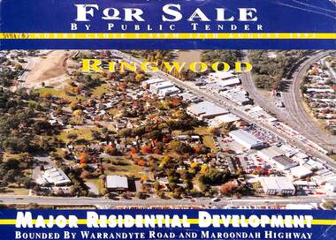
Flyer, Residential Development Sale by Public Tender, Ringwood, Victoria - 1993
... Total land 30,900 square metres. Lots 3 to 7 have plans available for 207 units. ...Total land 30,900 square metres. Lots 3 to 7 have plans available for 207 units. ...Double-sided brochure with map advertising major residential development bounded by Warrandyte Road and Maroondah Highway, Ringwood. Seven allotments facing Aird Street, Pratt Street, Bardia Street, Larissa Avenue and Suda Avenue offered as a whole or separately. Total land 30,900 square metres. Lots 3 to 7 have plans available for 207 units. Tenders close 5pm 12th August 1993. Agents - Michael Lewin, Simon Conquest, Talbot Birner Morley, 191 Balaclava Road Caulfield North (Tel) 5259222.