Showing 504 items matching "map of operations"
-
 Lara RSL Sub Branch
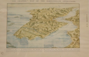
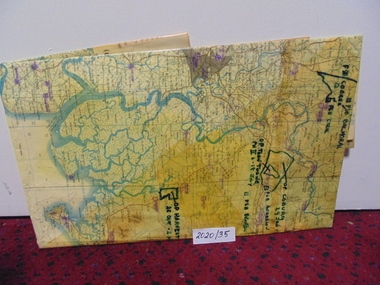
Topagraphical Map of the Dardanelles Operations, Graphic Map of The Dardanelles Operations
... Topagraphical Map of the Dardanelles Operations...Graphic Map of The Dardanelles Operations...WW1, Dardanelles operational map of area of Operations. Military, Naval of the "battering of the Gates of Constantinople"... of The Dardanelles Operations Topagraphical Map of the Dardanelles Operations ...WW1, Dardanelles operational map of area of Operations. Military, Naval of the "battering of the Gates of Constantinople"WW! ANZAC, British Military and Naval Operations in the Dardanelles. "battering of the Gates of Constantinople"Graphical representation of the Dardanelle's Operations displaying the Australia & New Zealand and the British operational areas and Landings. Military and Naval involvements in battering the gates to Constantinople.Small circular stamp on front left bottom - "State Library of N.S.W." and on he right hand border " Z M2 390 8/1915/3"ww!, military, naval, battering of the gates of constantinople, australia and new zealand (anzac) -
 Moorabbin Air Museum
Document (Item) - Ansett Map of Operations in Northern Queensland, Cairns Aerial Service
... Ansett Map of Operations in Northern Queensland...Beige manila folder Cairns Aerial Service Document Ansett Map of Operations in Northern Queensland ...Contains two copies of an undated map of Ansett routes in Northern Queensland. -
 National Vietnam Veterans Museum (NVVM)
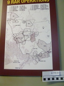
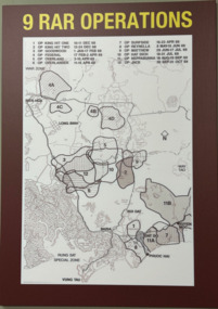
Poster - Poster, Information Board, 9 RAR Operations Listing Twelve Operations during the Vietnam War
... ...Map of operations...Map of 9 RAR operations with a burgundy background. there is a list of 12 operations and dates on the board...National Vietnam Veterans Museum (NVVM) 25 Veterans Drive Newhaven phillip-island-and-the-bass-coast 9 RAR Map of operations Poster Information Board Operation King Hit Operation Goodwood Operation Federal Operation Overland Operation Overlander Operation Surfside Operation Reynella Operation Matthew Operation Hat Dich Operation Neppabunna Operation Jack Bien Hoa Long Binh Nui Dat Baria Phuoc Hai Vung Tau Map of 9 RAR operations with a burgundy background. there is a list of 12 operations and dates on the board 9 RAR Operations Listing Twelve Operations during the Vietnam War Poster Poster, Information Board ...Map of 9 RAR operations with a burgundy background. there is a list of 12 operations and dates on the board9 rar, map of operations, poster, information board, operation king hit, operation goodwood, operation federal, operation overland, operation overlander, operation surfside, operation reynella, operation matthew, operation hat dich, operation neppabunna, operation jack, bien hoa, long binh, nui dat, baria, phuoc hai, vung tau -
 Melbourne Legacy
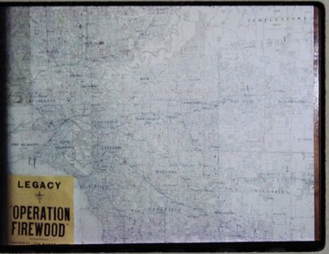
Slide, Operation Firewood, 1960s
... Three colour slides of a map of Metropolitan Melbourne with pins showing many delivery addresses. It was during Operation Firewood. ...Colour slide x 3 of a map of Melbourne during Operation Firewood in white cardboard mount....Hand written on one slide 'Map of Operation Firewood' in pencil....Hand written on one slide 'Map of Operation Firewood' in pencil. Colour slide x 3 of a map of Melbourne during Operation Firewood in white cardboard mount. ...Three colour slides of a map of Metropolitan Melbourne with pins showing many delivery addresses. It was during Operation Firewood. Legatees would organise collection of wood from the country and distribute it to widows in metropolitan Melbourne. Other slides show the cutting and loading of wood and delivery to widows in metropolitan Melbourne. Was with many other slides taken in the 1950s and 1960s. The slides have been photographed to make digital images and moved to archive quality sleeves. In many cases the original images were not well focussed and the digital image the best available.A record of Legacy helping widows by sourcing, supplying and delivering firewood. When open fires were the main source of heating, a load of firewood and help moving it, would have been very important to the widows.Colour slide x 3 of a map of Melbourne during Operation Firewood in white cardboard mount.Printed on front in blue ink 'Made in Australia'. Hand written on one slide 'Map of Operation Firewood' in pencil.operation firewood, maps -
 Ringwood RSL Sub-Branch
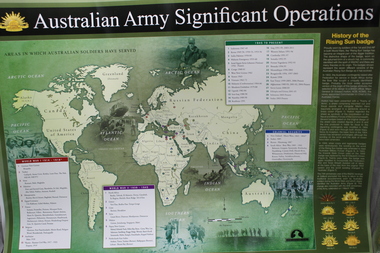
Work on paper - Australian army significant operations map, Memorabilia
... World map of operations x 2...Ringwood RSL Sub-Branch 16 Station Street Ringwood melbourne World map of operations x 2 Memorabilia Work on paper Australian army significant operations map ...World map of operations x 2 -
 National Vietnam Veterans Museum (NVVM)
Map
... A large laminated coloured map of Joint Operations Graphic (ground), Vietnam. there are specific information highlighted in pen....National Vietnam Veterans Museum (NVVM) 25 Veterans Drive Newhaven phillip-island-and-the-bass-coast 3RAR McPhail Collection Map A large laminated coloured map of Joint Operations Graphic (ground), Vietnam. there are specific information highlighted in pen. ...A large laminated coloured map of Joint Operations Graphic (ground), Vietnam. there are specific information highlighted in pen.3rar, mcphail collection, map -
 National Vietnam Veterans Museum (NVVM)
Map - 9 RAR Operations
... Map...Operation King One...Just above the map are numbers and operations, dated, that match the region marked....Map 9 RAR Operations ARCI Signs ...Maroon coloured board with 9RAR Operations. Map of Vietnam inside a white rectangle are regions mared on with outlines and numbered. Just above the map are numbers and operations, dated, that match the region marked.9RAR Operations, 1. King hit one 10-11 Dec 68 2. King hit two 12-24 Dec 68 3. Goodwood 1 Jan-17 Feb 69 4. OP Federal 17 Feb-2 April 69 5. OP Overland 2-10 April 69 6. OP overlander 11-15 April 69 7. OP Surfside 16-23 April 69 8. OP Reynella 8May-15June 69 9. OP Matthew 29 June-17July 69 10. Op hatditch 18-31 July 69 11. OP Neppabunna 18 Aug-15 Sept 69 12. OP Jack 30 Sept-31 Oct 699 rar, map, operation king one, operations king hit two, operation goodwood, operation federal, operation overland, operation overlander, operation surfside, operation reynella, operation matthew, operation hat dich, operation neppabunna, operation jack -
 Lara RSL Sub Branch
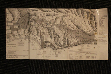
Group of Maps World War One, Group of Maps World War One - Dardanelles and Anzac Gallipoli Maps Circ 1915, Circ 1916
... Gallipoli 1915 Maps and Naval plan of Operations World War One ANZAC...Lara RSL Sub Branch McClelland Ave Lara Gallipoli 1915 Maps and Naval plan of Operations World War One ANZAC Rare examples that explain both ANZAC and Naval Operations during World War One Gallipoli & Dardanelles Passage . maps operational of anzac and naval opations during 1915 etc dardanelles naval opations 1. ...Gallipoli 1915 Maps and Naval plan of Operations World War One ANZACRare examples that explain both ANZAC and Naval Operations during World War One Gallipoli & Dardanelles Passage .!. Black and White Photocopy of Gallipoli 1915 ANZAC Battlefield - detailed positions of troops and Cemeteries. 2.The Allied Failure to Force The Dardanelles Passage 18 March 1915 - detailed line of Attack Naval Organisation, Mine layout, Plan of Attack (and copy).. 3. Map of Turkey and surrounding area written in Turkish and German Languages. C0olor version main roads and distances. (and copy).. 4. Map of ANZAC Trench Diagram. World War One.Color. (and copy). 5.Panorama of Chunuk Blair from 3 miles south of Nibrunesi Point, 3 November 1915 and Anzac from 1 mile N. E. of Ari Burnu, 21 November 1915. Black & White 6. Color Map of ANZAC positions with topographical Details, notes. 1. Artwork and copyright by Srewart Cownie, Gallipoli 1915 ANZAC Battlefield with Landings and later evacuation marked. 2. Details of Naval actions taken in the Dardanelles Passage 18 March 1918. 3. Local area Map or Turkey. Shows roads network and townships. 4. ANZAC Trench Diagram, copyright Whitcombe & Tombs Limited , Wellington N.Z. 1919 5. Panorama of two coast views of ANZAC area. Australian War Memorial, 6. Map of ANZAC positions of World War One, Gallipoli 1915. Published by H.E.C. Roberinson, George Street, Sydney N.S.W.18 April 1916maps operational of anzac and naval opations during 1915 etc, dardanelles naval opations -
 Bendigo Military Museum
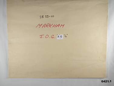
Map - SB55-10 Markham Joint Operations Graphics Air and Ground print separations, Royal Australian Survey Corps, Bendigo, Dec 1981
... The collection is a complete set of individual color prints of each colour used on the final printed maps for each map Joint Operations Graphic (JOG) JOG Ground and JOG Air versions. ...The collection is a complete set of individual color prints of each colour used on the final printed maps for each map Joint Operations Graphic (JOG) JOG Ground and JOG Air versions. ...This set of map prints was assembled as a training aid. The collection is a complete set of individual color prints of each colour used on the final printed maps for each map Joint Operations Graphic (JOG) JOG Ground and JOG Air versions. This map series was produced in two versions to help coordinate military Ground Operations and Air Operations. The ground users required that heights and measurements were in Metres, whilst air users required height information in Feet for altimeters. The Air Version also contained more Aeronautical information including safe flying height information called Maximum Elevation Figures (MEF). Later printing of JOG incorporated printing in just four colours Cyan, Magenta, Yellow and Black (CMYK). Item 6421.1 is an example of a JOG Ground and item 6421.2 is an example of its matching JOG Air version.1:250,000 SB55-10 Markham JOG A and G colour separations bound together in a manilla card covered folder bound with a timber edge. royal australian survey corps, rasvy, fortuna, army survey regiment, army svy regt, asr -
 Ballarat Tramway Museum
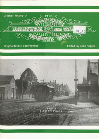
Book, Dean Filgate, "A Brief History of The Melbourne Brunswick and Coburg Tramways Trust", 1999
... Provides details on the formation of the Trust, appointments, financials, track and overhead construction, power supply, street lighting, depot and offices, opening, map, tickets, staff, operation statistics, extensions, and rolling stock. ...Provides details on the formation of the Trust, appointments, financials, track and overhead construction, power supply, street lighting, depot and offices, opening, map, tickets, staff, operation statistics, extensions, and rolling stock. ...Book - titled "A Brief History of The Melbourne Brunswick and Coburg Tramways Trust", MBCTT, written by Bob Prentice and edited by Dean Filgate. Published by Tramway Publications 1999. Provides details on the formation of the Trust, appointments, financials, track and overhead construction, power supply, street lighting, depot and offices, opening, map, tickets, staff, operation statistics, extensions, and rolling stock. Illustrated with many photographs including a photograph of the Trust Tramways Band.Yields information about the tramways built by "The Melbourne Brunswick and Coburg Tramways Trust"Book - 24 pages including heavy card covers, titled "A Brief History of The Melbourne Brunswick and Coburg Tramways Trust", centre stapled.trams, tramways, mbctt, tramways band, coburg, construction -
 Bendigo Military Museum
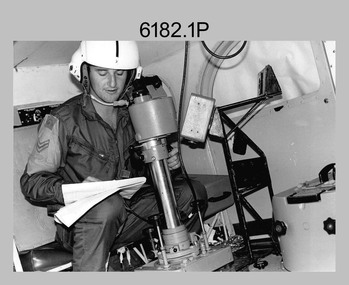
Photograph - Royal Australian Survey Corps Aerial Surveys, c1980
... operations flying mission with Aerodist, APR and RC10 camera equipment. The Australian Army’s Pilatus Porter (short take-off and landing turbo propeller) was also equipped with a Wild RC10 aerial mapping camera for identification photography. The Pilatus Porter was also used on RA Svy’s map...A Beechcraft King Air aircraft, also used by RA Svy on air survey operations. .6) - Photo, colour, c1980s. An Australian Army Pilatus Porter, used by RA Svy on air survey and map field checking operations. ...A Beechcraft King Air aircraft, also used by RA Svy on air survey operations. .6) - Photo, colour, c1980s. An Australian Army Pilatus Porter, used by RA Svy on air survey and map field checking operations. ...This is a set of nine photographs of technicians from the Royal Australian Survey Corps operating aerial surveys equipment c1980s. In photo .1P, CPL Steve Gloster was operating a RC10 air survey camera mounted in an Australian Army Pilatus Porter aircraft. The Wild RC10 super wide-angle air survey cameras were first introduced in 1971, were equipped with virtual distortion free lenses for supplementary, spot and special photography. In photo .2P, Roger Rees was operating Air Profile Recorder (APR) equipment. it was possibly taken during OP NERVOSE 84, sometime between June – August 1984 when based in Ngukurr, Northern Territory. The APR was operated at this time in unison with an RC10 camera. In 1963 the Royal Australian Survey Corps introduced the radar airborne profile recorder (Canadian Applied Research Ltd, Mark V, Airborne Profiler Recorder) was introduced for 1:100,000 mapping to replace terrain heighting by aneroid barometry. Later in 1974-1975, the Australian developed WREMAPS II airborne laser terrain profile recorder was introduced. In photo .3P, Neil Jones appears at the door of Airsearch Beechcraft Queen Air aircraft, Registration / Serial VH-MWX. This aircraft was typically used by RA Svy on air survey operations flying mission with Aerodist, APR and RC10 camera equipment. The Australian Army’s Pilatus Porter (short take-off and landing turbo propeller) was also equipped with a Wild RC10 aerial mapping camera for identification photography. The Pilatus Porter was also used on RA Svy’s map field checking operations. Photo .9P was taken at a survey station at an unknown location. In this photo an Australian Army Kiowa Light Observation Helicopter (LOH) is supporting a field survey party undertaking Magnavox AN/PRR-14 portable Doppler satellite observations. The satellite receiver’s antenna is plumbed over the survey ground mark surrounded by white plastic panels. The panels were used to identify the survey station on aerial photography. Introduced in 1974–1975, the Magnavox AN/PRR-14 portable Doppler satellite (US Navy Navigation Satellite System – TRANSIT) receivers and computing system provided independent three-dimensional point positions anywhere in the world, anytime, in any weather accurate to about 1.5metres with precise satellite ephemerides. The Bell OH-58 Kiowa LOH was a family of military helicopters used for observation, utility, and direct fire support. It was identified by RA Svy in the mid-1970s that considerable time was lost in replacing unserviceable remote equipment by road. Therefore Aerodist operations (pre-dating satellite receiver operations) were fully supported by Army’s Kiowa LOH aircraft. This is a set of nine photographs of technicians from the Royal Australian Survey Corps operating aerial surveys equipment c1980s. .1P to .3P, .5P to .9P - Colour and black and white photos on photographic paper and scanned at 300 dpi. .4P - Colour photo on 35mm slide film and scanned at 96 dpi. .1) & .2) - Photo, black & white, c1980s, CPL Steve Gloster operating an RC10 air camera. .3) - Photo, colour, 1984, Roger Rees operating Air Profile Recorder (APR) equipment. .4) - Photo, colour, c1980s, Neil Jones at the door of an Airsearch Beechcraft Queen Air aircraft, typically used by RA Svy on air survey operations. .5) - Photo, colour, c1980s. A Beechcraft King Air aircraft, also used by RA Svy on air survey operations. .6) - Photo, colour, c1980s. An Australian Army Pilatus Porter, used by RA Svy on air survey and map field checking operations. SGT Peter Mustart is possibly in the foreground. .7) to .8) - Photo, colour, c1980s. An Australian Army Pilatus Porter and unidentified personnel, used by RA Svy on air survey and map field checking operations. .9) - Photo, colour, c1980s. An Australian Army Kiowa helicopter supporting a field survey party undertaking Magnavox AN/PRR-14 portable Doppler satellite observations. There are biro marks on photos .4P to .9Proyal australian survey corps, rasvy, army survey regiment, asr, fortuna, aerial surveys -
 National Vietnam Veterans Museum (NVVM)
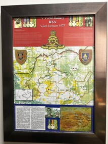
Poster - Information Board - A Field Battery RAA, South Vietnam 1971, A Field Battery RAA, South Vietnam 1971
... Silver framed display board of A Field Battery RAA, South Vietnam 1971with map, photos and notes of Operation Overlord - contact 7th June, 1971. ...National Vietnam Veterans Museum (NVVM) 25 Veterans Drive Newhaven phillip-island-and-the-bass-coast A Field Artillery Operation Overlord RAA Lance-Bombardier Peter (Blue) Martin Maher 55740 Royal Regiment Of Australian Artillery Military Medal MM Killed in Action Gnr Bayne Daniel (Gus) Kelly 2795310 12th Field Regiment 5th Platoon 104th Field Battery The Royal Australian Regiment B Company 2nd Lt Ian George Mathers 2794496 4th Field Regiment 42nd Us Artillery 1st Armoured Regiment A Squadron 3rd Cavalry Regiment Capt (Temp) Ian Michael Yerbury 43129 131 Divisional Locating Battery A Field Battery RAA, South Vietnam 1971 Silver framed display board of A Field Battery RAA, South Vietnam 1971with map, photos and notes of Operation Overlord - contact 7th June, 1971. ...Silver framed display board of A Field Battery RAA, South Vietnam 1971with map, photos and notes of Operation Overlord - contact 7th June, 1971. See media for more information.A Field Battery RAA, South Vietnam 1971a field artillery, operation overlord, raa, lance-bombardier peter (blue) martin maher, 55740, royal regiment of australian artillery, military medal, mm, killed in action, gnr bayne daniel (gus) kelly, 2795310, 12th field regiment, 5th platoon, 104th field battery, the royal australian regiment, b company, 2nd lt ian george mathers, 2794496, 4th field regiment, 42nd us artillery, 1st armoured regiment, a squadron, 3rd cavalry regiment, capt (temp) ian michael yerbury, 43129, 131 divisional locating battery -
 Melbourne Tram Museum
Book, Bob Prentice, Dean Filgate, "A Brief History of The Melbourne Brunswick and Coburg Tramways Trust", 1999
... Provides details on the formation of the Trust, appointments, financials, track and overhead construction, power supply, street lighting, depot and offices, opening, map, tickets, staff, operation statistics, extensions, rolling stock. ...Provides details on the formation of the Trust, appointments, financials, track and overhead construction, power supply, street lighting, depot and offices, opening, map, tickets, staff, operation statistics, extensions, rolling stock. ...Book - 24 pages including heavy card covers centre stapled - titled "A Brief History of The Melbourne Brunswick and Coburg Tramways Trust", MBCTT, written by Bob Prentice and edited by Dean Filgate. Published by Tramway Publications 1999. Provides details on the formation of the Trust, appointments, financials, track and overhead construction, power supply, street lighting, depot and offices, opening, map, tickets, staff, operation statistics, extensions, rolling stock. Illustrated with many photographs including a photograph of the Trust Tramways Band.trams, tramways, mbctt, tramways band, coburg, tramcars, construction -
 4th/19th Prince of Wales's Light Horse Regiment Unit History Room
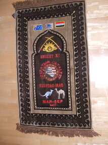
Textile - Prayer mat, 2007
... Embroidered with flags of Australia, Operation Catalyst and Afghanistan, Rising Sun badge flanked by crossed swords, SECDET XI, Map of Iraq surrounded by "OPERATION CITADEL", BAGHDAD-IRAQ, kangaroo and camel, MAR-SEP 2007...Embroidered with flags of Australia, Operation Catalyst and Afghanistan, Rising Sun badge flanked by crossed swords, SECDET XI, Map of Iraq surrounded by "OPERATION CITADEL", BAGHDAD-IRAQ, kangaroo and camel, MAR-SEP 2007 Textile Prayer mat Jabaseh, Germatex ...Souvenir of unit member from his deployment to SECDET XI of Operation Citadel, BAGDAD-IRAQ, Mar-Sep 2007Souvenir prayer mat. Embroidered with flags of Australia, Operation Catalyst and Afghanistan, Rising Sun badge flanked by crossed swords, SECDET XI, Map of Iraq surrounded by "OPERATION CITADEL", BAGHDAD-IRAQ, kangaroo and camel, MAR-SEP 2007souvenirs, afghanistan, embroidery, emblems, iraq -
 Bendigo Historical Society Inc.
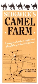
Ephemera - Camel Farm, about 1980s
... Camel Farm: Advertising Brochure complete with map of location, hours of operation, tours and prices. 2. ...Camel Farm: Advertising Brochure complete with map of location, hours of operation, tours and prices. 2. ...Now called Mattie's Sanctuary, it provides homes for all livestock animals although there is a particular emphasis on excess male camels from the camel dairies of regional Victoria.Sedgewick Camel Farm and Epsom Market Brochures 1. Camel Farm: Advertising Brochure complete with map of location, hours of operation, tours and prices. 2. Epsom Market, times and phone number, location, times of opening and invitation to become a seller. history, bendigo, merle lummis collection, sedgwick's camel farm, epson market -
 Bendigo Military Museum
Administrative record - 1 Fd Svy Sqn Project Report - Operation Carto Mercury 1986, 28 Jan 1986
... Operation Carto Mercury was a field completion Operation mounted by 1 Fd Svy Sqn 11 Aug 1985 to field complete 4 x 1:25000 compiled map sheet in the Cabarlah area to the North of Tawoomba. ...Bendigo Military Museum 37 - 39 Pall Mall Bendigo goldfields Operation Carto Mercury was a field completion Operation mounted by 1 Fd Svy Sqn 11 Aug 1985 to field complete 4 x 1:25000 compiled map sheet in the Cabarlah area to the North of Tawoomba. ...Operation Carto Mercury was a field completion Operation mounted by 1 Fd Svy Sqn 11 Aug 1985 to field complete 4 x 1:25000 compiled map sheet in the Cabarlah area to the North of Tawoomba. Included maps: 9243 - 23 Kingsthorpe, 9243 -24 Goombungee, 9243 - 21 Gomaren Creek, 9243 - 22 High FieldsA4 Typed document and diagrams, 14 pages. Report produced by 1 Fd Svy Sqn 1986royal australian survey corps, rasvy, fortuna, army survey regiment, army svy regt, asr, 1 fd svy sqn -
 Bendigo Military Museum
Map - MAPS, EAST TIMOR, US Govt et al, 1975 - 1976
... map. Its scale is 1.250,000 called a joint Operations Graphic. It manly covers West Timor. ...map. Its scale is 1.250,000 called a joint Operations Graphic. It manly covers West Timor. ...1. This is a coloured map. It's scale is 1.250,000 - called a jpoint operations graphic. It covers the North side of East Timor. Dili is in the centre. Its shows 4 Islands to the north of Timor. It shows Savu Fea, Ombai Strait, Wetar Strait. On bottom left of map it shows Batheade and the start of the New Border. Map - Series 159. Sheet 5C- 51-4. Edition 3-GSGS. 2. This is a coloured map. Its scale is 1.250,000 called a joint Operations Graphic. It manly covers West Timor. It shows Savu Sea in North and Timor Sea on south side. Series 1501. Sheet SC 51.7. Edition 3-GSGS. 3. This a coloured map. It's scale is 1.250,000. Joint operations graphic. This map shows the south side of East Timor and the Timor Sea. This map shows a highlighted New border. The major towns on South coast are KAMFNASA, BETANO. Map series 1501. Sheet SC 51-8. Edition 3 GSGS.1. Has highlighted "7 BSG" on coast. All maps show East Timor border highlighted in pink.east timor, maps, interfet -
 Bendigo Military Museum
Manual - TRAINING MANUALS VARIOUS, 1937, 1959
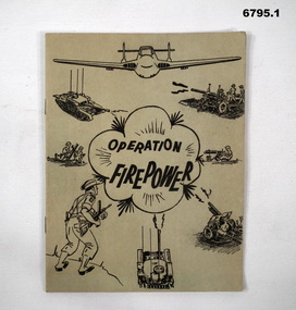
... Operation Firepower" . Dated March 1959, which planned an army exercise at Brigade Level. Outlined aim, Tactical setting, maps and plans. 2. ...Map Reading - Supplement A.T.M. (AUST) No 12". Written on top " Colonel J.W. Swatton". 3. Titled "Right or Wrong": Element of Training and Leadership illustrated 1937". Stamp on back saying "on loan" but now donated. 1. Green cover, 16 page booklet titled " Operation ...1. An instruction manual outlining the structure of a military exercise to practice Battle activity at a Brigade level. 2. An instruction manual outlining the proper way to read a map and the logic of it's structure. 3. Illustrative guide on what leaders should expect in relation to their soldiers. Items in the collection re Col J Swatton, refer Cat No 6719.2P for his service details.1. Green cover, 16 page booklet titled " Operation Firepower" . Dated March 1959, which planned an army exercise at Brigade Level. Outlined aim, Tactical setting, maps and plans. 2. Loose stapled 28 page manual on reading maps. Yellow paper with three folder holes punched in left size. Contains instructions and pictures and examples. 3. Brown covered manual, yellow faded pages, 60 pages inside with pictorial content displaying the do's and don't's of the behaviour of a good soldier.1. Maps have some notations, images of vehicles/weapons on front. 2. Titled " Map Reading - Supplement A.T.M. (AUST) No 12". Written on top " Colonel J.W. Swatton". 3. Titled "Right or Wrong": Element of Training and Leadership illustrated 1937". Stamp on back saying "on loan" but now donated.passchendaele barracks trust, training manuals -
 Bendigo Military Museum
Administrative record - Joint Committee for the exchange of Information on ADP within the RASvy Corps, Activities Jun- Dec 1985, Army Survey Regiment, December 1985
... Automated Computer Processing (ADP) was instrumental to the successful operation of the Royal Australian Survey Corps Mapping capability and production. This paper describes elements of the ADP with a comprehensive description of each. They Include, PDP 11/70 Memory, Map...Bendigo Military Museum 37 - 39 Pall Mall Bendigo goldfields Automated Computer Processing (ADP) was instrumental to the successful operation of the Royal Australian Survey Corps Mapping capability and production. This paper describes elements of the ADP with a comprehensive description of each. They Include, PDP 11/70 Memory, Map ...Automated Computer Processing (ADP) was instrumental to the successful operation of the Royal Australian Survey Corps Mapping capability and production. This paper describes elements of the ADP with a comprehensive description of each. They Include, PDP 11/70 Memory, Map Stock Control System, Digital Terrain Elevation Data, Digital Terrain Model Package, ASMAPS, ASTIS, Reflectance Hill Shading, Aerial Triangulation and Terrain Analysis.Two page paper report about Automated Data Processing, unstapledHand annotated "Folio 74" in top right hand cornerroyal australian survey corps, rasvy, fortuna, army survey regiment, army svy regt, asr -
 Bendigo Military Museum
Administrative record - Army Survey Regiment - Mallee Country Project, Army Survey Regiment, 30.01.1987
... Operation Raleigh is a scheme for International Venturers (Scouts) to develop leadership, self-reliance, initiative and team work while studying Mallee Fowl, Mammal Trapping and Cross Country Trekking. Four Annexes containing sketch maps...Operation Raleigh is a scheme for International Venturers (Scouts) to develop leadership, self-reliance, initiative and team work while studying Mallee Fowl, Mammal Trapping and Cross Country Trekking. Four Annexes containing sketch maps ...This is a reconnaissance report for the Mallee Country Project supporting Operation Raleigh 4 Mar - 26 May 1987. Operation Raleigh is a scheme for International Venturers (Scouts) to develop leadership, self-reliance, initiative and team work while studying Mallee Fowl, Mammal Trapping and Cross Country Trekking. Four Annexes containing sketch maps, personnel lists, photographs and stores lists.A4 Report, soft covers front and back. Plastic ring bindingroyal australian survey corps, rasvy, fortuna, army survey regiment, army svy regt, asr -
 Bendigo Military Museum
Photograph - Aerotriangulation Production – Army Survey Regiment, Fortuna, Bendigo, c1989
... See item 6195.19P for more photos of aerotriangulation equipment and their operation in map production....See item 6195.19P for more photos of aerotriangulation equipment and their operation in map production. Royal Australian Survey Corps RASvy Fortuna Army Survey Regiment air survey aerotrig .1P to .17P – There are no annotations This is a set of 17 photographs of Air Survey Squadron aerotriangulation equipment and personnel taken at the Army Survey Regiment at Fortuna, Bendigo, circa 1989. ...This collection of 17 photographs of Air Survey Squadron aerotriangulation equipment and personnel was taken at the Army Survey Regiment, Fortuna, Bendigo, circa 1989. The PDP 11/70 minicomputer was the operating system introduced in 1977 as the mainframe system for the control of the APC4, aerial triangulation block adjustments, SORA OP Analytical Orthophoto control, APR Analytical Terrain Profile Recorder computation, graphics, and general computing. The OMI/Nistri AP/C-3 analytical plotter shown in photo .1P to .6P and .9P was introduced in 1972–1973. The Zeiss (Jena) Stecometer analytic stereocomparator for air photography shown in photo .16P was introduced at Air Survey Squadron in 1963. Aerotriangulation production was expedited using computers for analytical photogrammetric processes. The technician accurately measured between pass, tie, and survey control points on aerial photographs. Wild PUG4 point transfer devices as shown in photo .17P, were introduced in c1968 superseding the PUG2 devices. PUG4 devices were used by technicians to stereoscopically view the photography containing the survey control points and the mapping aerial photography. The Control points were transferred from the control photography to the mapping diapositives of aerial photography by drilling their locations into the photographic emulsion. See item 6195.19P for more photos of aerotriangulation equipment and their operation in map production.This is a set of 17 photographs of Air Survey Squadron aerotriangulation equipment and personnel taken at the Army Survey Regiment at Fortuna, Bendigo, circa 1989. The photographs are on 35mm negative film and scanned at 96 dpi. They are part of the Army Survey Regiment’s Collection. .1) to .7) - Photo, black & white, c1989, OMI/Nistri APC/3-1 analytical stereoplotter. .8) - Photo, black & white, c1989, miscellaneous aerotriangulation equipment. .9) to.10) - Photo, black & white, c1989, Digital Equipment Corporation (DEC) 11 VO3-L Superminicomputer, with VT52 DECScope terminal. .11) to .15) - Photo, black & white, c1989, miscellaneous aerotriangulation equipment. .16) - Photo, colour, c1989, Zeiss (Jena) Stecometer, unidentified technician. .17) - Photo, black & white, c1989, Wild PUG4 point transfer device, unidentified technician..1P to .17P – There are no annotationsroyal australian survey corps, rasvy, fortuna, army survey regiment, air survey, aerotrig -
 Bendigo Military Museum
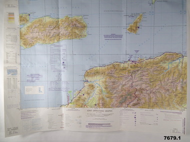
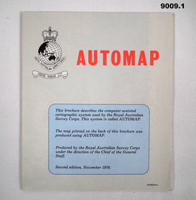
Map - Army Survey Regiment - Automap, Army Survey Regiment, Bendigo, 1 Nov 1979, .2 and .3 Aug 1980 and .4 December 1982
... .1 A folded Automap produced Map, Derby 1:100 000, Series 1611, Sheet 3663, Printed on one side and Automap flow diagram second Edition DEF/MISC/5157 on the other side. .2 and .3 Two copies of a folded Automap produced Map, Yampi 1:250 000, Series 1501 (Joint Operations Graphic), Sheet SE51-3, Edition 1, Printed on one side and Automap flow diagram third Edition DEF/MISC/5157C on the other side. .4 An Introduction to the Automap 2 System, A4 Booklet 16 x pages and a folded Automap2 flow diagram fifth Edition DEF/MISC/5157E Annex in the rear of the booklet....Royal Australian Survey Corps RASvy Fortuna Army Survey Regiment Army Svy Regt ASR .1 DEF/MISC/5157 .2 AND .3 DEF/MISC/5157C .4 DEF/MISC/5157E .1 A folded Automap produced Map, Derby 1:100 000, Series 1611, Sheet 3663, Printed on one side and Automap flow diagram second Edition DEF/MISC/5157 on the other side. .2 and .3 Two copies of a folded Automap produced Map, Yampi 1:250 000, Series 1501 (Joint Operations Graphic), Sheet SE51-3, Edition 1, Printed on one side and Automap flow diagram third Edition DEF/MISC/5157C on the other side. .4 An Introduction to the Automap 2 System, A4 Booklet 16 x pages and a folded Automap2 flow diagram fifth Edition DEF/MISC/5157E Annex in the rear of the booklet. ...These flow diagrams and in particular the Introduction to Automap 2 booklet is designed to provide a general description of the second phase of the AUTOMAP system (Automap 2) installed at the Army Survey Regiment, Bendigo. It contains information that managers and supervisors need to know and serves as a preliminary introduction for anyone interested in learning about AUTOMAP 2. In addition, a number of annexes are included to provide more detailed descriptions of significant features and components of the system. System Objectives. In order that RASVY can carry out its mapping programme effectively, an efficient production system is required that can acquire and edit digital data from a topographic data base and thence automatically produce high quality maps using that digital data. The existing system, AUTOMAP 1, provides a small part of such a system. AUTOMAP 2 expands the capabilities of AUTOMAP 1 in data capture, computing power and data handling for cartographic purposes. AUTOMAP 2 includes state-of-the-art technology, introduces interactive graphics as a production tool and shifts procedures from a current mix of analogue and digital technologies to an almost totally digital system. AUTOMAP 2 increases map production by at least 20 percent at the Army Survey Regiment. Project References. A wide range of user manuals and associated documentation is available for both the hardware and software components of the AUTOMAP system. Other related departmental references are listed at the rear of the booklet..1 A folded Automap produced Map, Derby 1:100 000, Series 1611, Sheet 3663, Printed on one side and Automap flow diagram second Edition DEF/MISC/5157 on the other side. .2 and .3 Two copies of a folded Automap produced Map, Yampi 1:250 000, Series 1501 (Joint Operations Graphic), Sheet SE51-3, Edition 1, Printed on one side and Automap flow diagram third Edition DEF/MISC/5157C on the other side. .4 An Introduction to the Automap 2 System, A4 Booklet 16 x pages and a folded Automap2 flow diagram fifth Edition DEF/MISC/5157E Annex in the rear of the booklet..1 DEF/MISC/5157 .2 AND .3 DEF/MISC/5157C .4 DEF/MISC/5157Eroyal australian survey corps, rasvy, fortuna, army survey regiment, army svy regt, asr -
 Bendigo Military Museum
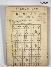
Map - TRENCH MAP, WW1, c. 1918
... Detailed trench map of locality to Guide and plan Defence and operations. Part of the collection of V E Giudice 53730. ...Bendigo Military Museum 37 - 39 Pall Mall Bendigo goldfields Detailed trench map of locality to Guide and plan Defence and operations. Part of the collection of V E Giudice 53730. ...Detailed trench map of locality to Guide and plan Defence and operations. Part of the collection of V E Giudice 53730. Refer to Cat. No. 10031P for his details. Part of the overall William (Bill) Thomason Collection.Large white hard paper map of Rumilly Trenches with Town of Rumilly, Masneriei and Crevecoeur and The Canal, St Quentin. Full contour lines marked and showing the Beaurevoir Line of Trenches. Is to scale of 1:10,000. Mainly blank on back except a table to index adjoining sheets and a glossary of locations. Translation from French to English.Signed on front "V E Giudice" and "O/C ACO and something indecipherable.v e giudice, collection of william (bill) thomason, trench map, ww1 -
 Bendigo Military Museum
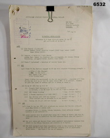
Administrative record - Royal Australian Survey Corps - Central Command Operation Order C/1/61 Northern Territory 1961, DAD Svy, HQ Central Command , Keswick Barracks, SA, 1961
... This is a Central Command Operation Order for the Royal Australian Survey Corps to conduct a Survey Operation in Northern Territory in 1961. The task is to acquire Survey Control for the production of maps coving the following 1:250 000 map areas of Alligator River, Mt Evelyn, Coburg Peninsula, (including the offshore Islands, Melville Island and Bathurst Island. ...Bendigo Military Museum 37 - 39 Pall Mall Bendigo goldfields This is a Central Command Operation Order for the Royal Australian Survey Corps to conduct a Survey Operation in Northern Territory in 1961. The task is to acquire Survey Control for the production of maps coving the following 1:250 000 map areas of Alligator River, Mt Evelyn, Coburg Peninsula, (including the offshore Islands, Melville Island and Bathurst Island. ...This is a Central Command Operation Order for the Royal Australian Survey Corps to conduct a Survey Operation in Northern Territory in 1961. The task is to acquire Survey Control for the production of maps coving the following 1:250 000 map areas of Alligator River, Mt Evelyn, Coburg Peninsula, (including the offshore Islands, Melville Island and Bathurst Island. The Operation Order details the tasks for the 6 x Officers (or equivalent) and 34 x OR's (or equivalent) and the support that was allocated including Frigate HMAS Gasgoyne, LSM landing craft, Trucks amphibian (DUKW), Helicopter and Cessna aircraft.A 11 x page foolscap size paper report and 1 x foldout map Annex held together with a paper clip. Two hole punched.Hand written File Number in top RH Corner "101-310-4". Distribution stamp in top LH Corner. Hand written No7 in Top RH Corner.royal australian survey corps, rasvy, fortuna, army survey regiment, army svy regt -
 Bendigo Military Museum
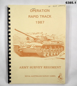
Administrative record - Army Survey Regiment - Operation Rapid Track 1987 Operation Report, Army Survey Regiment, Bendigo, 27 May 1987
... The Survey Operation Report deals with the cartographic completion of four 1:50,000 topographical line maps and one Special 1:50,000 map covering the Puckapunyal Military Training Area. ...Bendigo Military Museum 37 - 39 Pall Mall Bendigo goldfields The Survey Operation Report deals with the cartographic completion of four 1:50,000 topographical line maps and one Special 1:50,000 map covering the Puckapunyal Military Training Area. ...The Survey Operation Report deals with the cartographic completion of four 1:50,000 topographical line maps and one Special 1:50,000 map covering the Puckapunyal Military Training Area. The report covers in detail the digital stereo plotting, field completion (checking) and the cartographic completion including printing. The four 1:50.000 maps are 7823-1 PYALONG, 7824-2 COSTERFIELD, 7923-4 TALLAROOK and 7924-3 NAGAMBIE. Annex A lists personnel and dates involved and is attached as 6385.2. Annex B lists the members of the field completion parties.A4 sized buff coloured light cardboard covered report, plastic spiral binding. Front cover includes text, Survey Corps badge and light brown image of a Centurian tank. "To Tech Library", Page 2 has two small handwritten notes indicating that Phase 2 was the Field Completion Phaseroyal australian survey corps, rasvy, fortuna, army survey regiment, army svy regt, asr -
 Kiewa Valley Historical Society
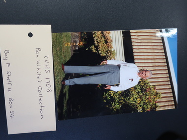
Ron White's Collection - 1920 - 2019
... Operations social club 1962 x2 6. The Association of Professional Engineers, Victorian Branch receipts 1956 7. Upper Kiewa Valley Uniting Church list of members 1969-1970 & Financial Statement for 1970 8. 4 Bogong Village coloured postcards 9. Folded Plan of 'Kiewa Area Planimetric Map...Operations social club 1962 x2 6. The Association of Professional Engineers, Victorian Branch receipts 1956 7. Upper Kiewa Valley Uniting Church list of members 1969-1970 & Financial Statement for 1970 8. 4 Bogong Village coloured postcards 9. Folded Plan of 'Kiewa Area Planimetric Map ...The State Electricity Commission of Victoria constructed the Kiewa Hydro Electric Scheme.See KVHS 1282Ron White was the Principal Hydro Engineer 1966 - 1985 on the Kiewa Hydro Electric Scheme. See KVHS 12821. Booklet "Rules of the Kiewa Hydro Co-operative Distribution Society Limited" and Ron's 'Share Certificate' dated 12th /4/1957 2. Book "Inside Information" explaining the ins and outs of a car for the motorist. 3. Black and White negatives 4. Ron's La Trobe Valley Health Services Membership card x2 5. State Savings Bank of Victoria Kiewa Operations social club 1962 x2 6. The Association of Professional Engineers, Victorian Branch receipts 1956 7. Upper Kiewa Valley Uniting Church list of members 1969-1970 & Financial Statement for 1970 8. 4 Bogong Village coloured postcards 9. Folded Plan of 'Kiewa Area Planimetric Map' 10. Large Photos sent to Ron by "Bill Greenaway / Y.T.S. Lab./ 11-5-66" 1) Football Team x2, 2) Mt Beauty Switchyard, 3) McKay Power Station, 4) Clover Power Stationron white -
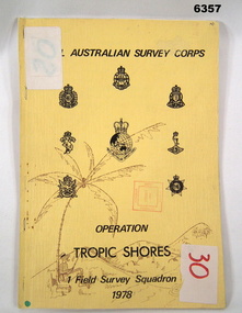 Bendigo Military Museum
Administrative record - Royal Australian Survey Corps - Operation Tropic Shores, 1 Field Survey Squadron 1978, 31 Aug 1978
... maps. Cover has Title and the Badges of the Australian Army Corps who participated in the Operation. ...maps. Cover has Title and the Badges of the Australian Army Corps who participated in the Operation. ...Operation Tropic Shores was conducted in 2 phases, Sep 1977 and May / Jun 78. The Operation was the field completion of Cape York 1;50,000 Mapping North of latitude 15 degrees S. Plotting was undertaken by 2, 4 and 5 Fd Svy Sqns with 1Fd Svy Sqn undertaking the mounting and Management of the field completion phase. Re-visiting and targeting of existing trig stations was also carried out as an opportunity task.Booklet, A4 cream cardboard cover, stapled Left Hand side, containing a report and plotted maps. Cover has Title and the Badges of the Australian Army Corps who participated in the Operation. 2 fd svy sqn, 4 fd svy sqn, 5 fd svy sqn, royal australian survey corps, 1 field survey squadron, 1fd svy sqn, rasvy, fortuna, army survey regiment, army svy regt, asr -
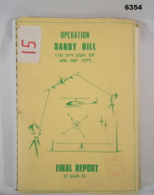 Bendigo Military Museum
Administrative record - Operation Report - Operation Sandy Hill 1Fd Svy Sqn Apr - Sep 1975, 1 Fd Svy Sqn, 1976
... Bendigo Military Museum 37 - 39 Pall Mall Bendigo goldfields Comprehensive Operation Report on Operation Sandy Hill conducted by 1Fd Svy Sqn Apr-Sep 1975 Part 1 Forward, Part 2 Planning and Mounting, Part 3 Final Report OC 1 Fd Svy Sqn, Part 4 Report Abn/EDM Gp, Part 5 Report Recon, Stn Marking and Traversing Gp, Part 6 Admin Report, Part 7 Report OC 171 Op Spt Sqn, Part 8 Computations and Results, Part 9 Observations and Recommendations. Royal Australian Survey Corps RASvy Fortuna Army Survey Regiment Army Svy Regt ASR "15" on front cover. Rubber stamp "Army Survey Regiment Map ...Comprehensive Operation Report on Operation Sandy Hill conducted by 1Fd Svy Sqn Apr-Sep 1975 Part 1 Forward, Part 2 Planning and Mounting, Part 3 Final Report OC 1 Fd Svy Sqn, Part 4 Report Abn/EDM Gp, Part 5 Report Recon, Stn Marking and Traversing Gp, Part 6 Admin Report, Part 7 Report OC 171 Op Spt Sqn, Part 8 Computations and Results, Part 9 Observations and Recommendations.A4 size report held together with a plastic spiral binding, Light Cardboard cover includes many foldout Annexes"15" on front cover. Rubber stamp "Army Survey Regiment Map Library"royal australian survey corps, rasvy, fortuna, army survey regiment, army svy regt, asr -
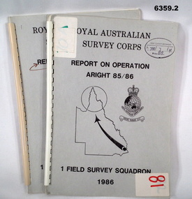 Bendigo Military Museum
Administrative record - Royal Australian Survey Corps Report on Operation Aright 85 / 86 1 Field Survey Squadron 1986, 1986
... Operation ARIGHT 85 was mounted by 1 Fd Svy Sqn 14 May to 8 Aug 1985 and 1 May to 15 May 1986. In the 1:250,000 SG54-15 Rutland Plains map area. ...A4 Cardboard cover, grey, plastic ring binder, report, diagrams, maps, plastic ring binder. Royal Australian Survey Corps Report on Operation Aright 85 / 86 1 Field Survey Squadron 1986. ...Operation ARIGHT 85 was mounted by 1 Fd Svy Sqn 14 May to 8 Aug 1985 and 1 May to 15 May 1986. In the 1:250,000 SG54-15 Rutland Plains map area. In addition 18 X 1:50 000 maps were field completed.6359.1 Copy 1. 6359.2 Copy 2. A4 Cardboard cover, grey, plastic ring binder, report, diagrams, maps, plastic ring binder.royal australian survey corps, 1 field survey squadron, 1fd svy sqn, rasvy, fortuna, army survey regiment, army svy regt, asr -
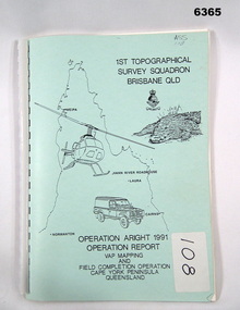 Bendigo Military Museum
Administrative record - Royal Australian Survey Corps Report on Operation Aright 91 conducted by 1 Field Survey Squadron 1991, 1 Fd Svy Sqn, 7 Oct 1991
... The Operation covered the 1:250,000 Map area of SD54-16 Hann River and SE54-7 Normanton....The Operation covered the 1:250,000 Map area of SD54-16 Hann River and SE54-7 Normanton. ...Royal Australian Survey Corps Operation Aright 91 (Field Completion) was a Field Verification and Vital Assets Protection (VAP) Mapping Operation conducted in Far North Queensland during the period 18 Jun - 29 Jul 1991 by 1 Fd Svy Sqn. The Operation covered the 1:250,000 Map area of SD54-16 Hann River and SE54-7 Normanton.Pale Blue cover with motifs of North Queensland, crocodile, RASvy Corps Badge, Army Helicopter and Land rover. Contains an A4 paper report of typed pages and diagrams secured by a plastic binder.Cover Hand annotated "ASS 108" (Air Survey Sqn, copy 108)royal australian survey corps, rasvy, fortuna, army survey regiment, army svy regt, asr